Contemporary Land Use Policy in Quito: Towards a More Equitable Approach By
Diana X. Bell
B.A. Political Science
University of Massachusetts, Boston (2005)
Submitted to the Department of Urban Studies and Planning in partial fulfillment of the requirements for the degree of
Master in City Planning
MASSACHUSETTS INSTITUTE
at the OF TECHNOLOGY
MASSACHUSETTS INSTITUTE OF TECHNOLOGY
SEP 22 2016
September 2016
LIBRARIES
ARCHIVES
2016 Diana X. Bell. All Rights ReservedThe author hereby grants to MIT the permission to reproduce and to distribute publicly paper and electronic copies of the thesis document in whole or in part in any medium now known or hereafter created.
Author
Signature redacted
Dep nt etddies and Planning
08/23/2016
Certified by
Professor Balakrishnan Rajagopal Department of Urban Studies and Planning (7) /)I ,.,) Thesis Supervisor
Accepted by
Signature redacted
Associ rofessor P. jhristopher Zegras Chair, MCP Committee Department of Urban Studies and Planning
Contemporary Land Use Policy in Quito: Towards a More Equitable Approach By
Diana X. Bell
Submitted to the Department of Urban Studies and Planning on August 23rd, 2016 in partial fulfillment of the Requirements for the Degree of Master in City Planning
ABSTRACT
In 2008, a transformational moment took hold in Ecuador, when through a highly
democratic process, a new constitution was established based in a more inclusive and equitable sense of rights and development. Among other changes, this included direct implications for land rights and land use considerations. This was, and continues to be, highly important as land rights questions have long been a central component in the platforms of historically
marginalized groups- Indigenous communities, Afro-Ecuadorians and Montubios.
This thesis examines how (or how not) land use policies since 2008 have translated into more equitable approaches. In Quito where land rights and land use challenges persist,
particularly from the vantage of historically marginalized communities and neighborhoods, the question of moving towards more equitable approaches to land use policies is an urgent one. To examine this question I first look at why equitability is important and what it implications it holds in relation to land use and land rights questions. This is done through an analysis of four frames of consideration: (1) The Spatial; (2) The Political Historical context; (3) The Theoretical; (4) Insights from those engaged in land rights struggles and policymaking.
Using these frame of analysis, this study evaluates the principle secondary laws that have been enacted post 2008 and finds that: 1) The passage of these policies is evidence of strong progress made towards more equitable approaches to land use planning in the post 2008 period. 2) While this progress is undeniable and deeply significant, critical dimensions of equitability remain unaddressed. Land rights questions of indigenous communities, questions of governance, aspects of market regulation- among other concerns- continue to persist.
To deepen equitability in land policy making, I argue that, in addition to ensuring strong implementation of recent policies, a more comprehensive notion of equitability must be embraced and translated into existing and new regulatory instruments and frameworks.
Thesis Advisor: Balakrishnan Rajagopal
ACKNOWLEDGEMENTS
I would like to express my deep appreciation to my thesis adviser, Professor Balakrishnan Rajagopal, for his unwavering support and excellent feedback throughout the thesis process. I learned extensively from his knowledge and analysis of land and displacement issues and am indebted for that guidance.
I would also like to thank Professor J. Phillip Thompson for providing critical advice and feedback as my thesis reader and for his strong support throughout my MCP experience. His guidance in this study and other courses I have taken in the Department have been invaluable
in sharpening my understanding of equity and equity centered planning.
Professor Sai Balakrishnan was also a critical support in various stages of my thesis process. Early on her guidance helped shape how I approached my study and analysis of land in Ecuador and her course 'The Spatial Politics of Land' pushed me to think in new ways about land
concerns and has been an inspiration in my interest to explore more equity centered land models.
The opportunity to talk with and learn from leaders engaged in land policy making across the city was fundamental to informing the analysis and findings of this study, to them I express great appreciation and respect for the important work they are moving forward.
Last, but definitely not least, I give infinite thanks to my family for their love and steadfast support and belief in my work.
TABLE OF CONTENTS
Abstract ... 2
Acknow ledgem ents...3
List of Figures...6
Introduction...7
Chapter I: Socio Spatial Segregation and Territorial Inequality in Quito ... 11
1.1 Refraim ing land in the urban context... 11
1.2 The Socio Spatial Segregation of Quito... 15
1.3 Socio Spatial Segregation in Quito: How did we get here?...22
Chapter II: The Political & Historical Context... 26
2.1 The Territorial Claims of Historically Marginalized communities... 26
2.1.1 The Indigenous M ovem ent... 27
2.1.2 The Afro Ecuadorean M ovem ent... 31
2.2 New Paradigm s: 'Buen Vivir' and Right to the City... 33
2.2.1 Buen Vivir... 35
2.2.2 Right to the City ... 3 7 2.3 The Expanding Regional Context: Brazil + Colom bia ... 38
Chapter III: Theorizing on Land... 41
3.1 Dom inant fram ew orks... 41
3.2 Land reform ... 44
3.3 Right to the City and the Right to Land ... 47
Chapter IV: Land Use Q uestions of Q uito... 48
4.1 Civil society perspective... 49
4.1.1 Challenges Identified... 49
4.1.2 Solutions Needed... 52
4.2 Governm ental perspective... 53
4.2.1 Challenges Identified... 54 4.2.2 Solutions Needed... 55 4.3 Research perspective... 57 4.3.1 Challenges Identified... 57 4.3.2 Solutions Needed... 60 4.4 Issues Identified... 61
Chapter V: Contem porary Land Policy... 63
5.1 National Policies... 65
5.1.1 Organic Code of Territorial Organization, Autonomy and Decentralization... 65
5.1.2 Law of Territorial Planning, Land Use and Land Use M anagem ent... 67
5.2 M unicipal Policies... 70
Chapter VI: Junctures and Disjunctures... 73
6.1 Junctures... 73
6.2 Disjunctures... 76
Chapter VII: Concluding Thoughts and Recom m endations ... 79
7.1 O pportunities and barriers... 80
7.2 Recom m endations... 82
7.3 Lim itations of Study and Areas for Further Research... 85
References...87
LIST OF FIGURES AND MAPS
Figure 1. Sur de Quito... 12
Figure 2. Norte d e Quito (Barrio Quito Tenis)... 12
Figure 3. Norte de Quito (Bellavista)... 13
Figure 4. Table of Articles in 2008 Constitution with Implications for equity centered Land P o licy ... 3 4 Figure 5. Flyer in Quitumbe (Sur de Quito) protesting taxes, calling for popular Referendum ... 50
Figure 6. Factory Adjacent to Lucha de los Pobres Neighborhood, Sur de Quito... 51
Figure 7. Social Interest Housing in the outskirts of Quitum be... 58
M ap 1. Poverty by Adm inistrative Zone... 16
M ap 2. Urban Services...17
M ap 3. M anufacturing Sites... 19
INTRODUCTION
In 2008 Ecuador underwent a transformational moment when, through a highly democratic process that included broad civil society participation, a new constitution was developed and enacted based in a radically new vision of rights and development. Concepts like Buen Vivirl, Plurinacionaliad/Plurinationality and the Right to the City included in the new constitution spoke of rights in more inclusive, equitably centered ways and (among other changes) included direct implications for land use and land rights considerations. This was, and continues to be, highly important as land rights questions have long been a central component in the political demands of historically marginalized groups- indigenous communities, afro
Ecuadorians and montubios2. It is also significant as land use considerations are fundamental to
how a state defines and shapes its development.
The significance of having these concepts recognized in the new constitution and of the salience of these (land rights and land use) questions in the politics of development makes it imperative to ask: have the changes of 2008 translated into more equitable land use policies? In Quito where land rights and land use challenges persist, particularly from the vantage of historically marginalized communities and neighborhoods, the question of moving towards more equitable approaches to land use policies is an urgent one.
To examine this question this study considers how contemporary land policy (post 2008), chiefly at the national level, accounts for questions of equitability. To do this,
considerable attention is first given to understanding and defining equitability as it relates to land use and land rights questions. This is done through an analysis of four frames of
consideration:
1 Buen Vivir or Sumak Kawsay is a quecha term that comes from an ancestral 'cosmovision' of community
development in balance with nature, for good living. As will be explored later it is also inclusive a much broader sense of set of rights.
2 Montubio are indigenous mestizo people of coastal Ecuador, they are a community that is recognized in the
1) The Spatial- taking stock of socio spatial segregation in Quito 2) The Political-Historical context
3) The Theoretical- centering land reform as a particularly instrumental frame of analysis 4) Insights from the ground- taking up the expertise and 'ground' knowledge of those engaged in struggles around land rights or involved in land use policymaking
These considerations are used to inform what elements should be included in more equitable approaches to land use policy making and planning in Quito. In as such, they also provide important points of reference for taking stock of how (or how not) recent policies address equity concerns. I ask: do contemporary policies speak to the (transformative) concepts included in the constitution? What aspects address the land rights concerns and conditions of historically marginalized communities?
In looking at the two principle secondary laws aimed at regulating land use- the Organic Code of Territorial Organization, Autonomy and Decentralization (C6digo Org6nico de
Organizaci6n Territorial, Autonomia y Descentralizaci6n or COOTAD) and the very recent Law of
Territorial Planning, Land Use and Land Use Management (Ley Org6nica de Ordenamiento
Territorial, Uso y Gesti6n de Suelo)- this study finds that:
1) The passage of these policies is evidence of strong progress made towards more equitable approaches to land use planning in the post 2008 period.
2) While this progress is undeniable and deeply significant, critical dimensions of equitability remain unaddressed. Land rights questions of indigenous communities, questions of governance, aspects of market regulation- among other concerns- continue to persist.
To deepen equitability in land policy making, I argue that a more comprehensive notion of equitability must be embraced and translated in regulatory instruments or frameworks. This includes more redistributive approaches to land value capture and land tax policies, land use
management practices that better integrate and respect territorial autonomy of indigenous communities and reforming how infrastructure and other basic services are accessed.
This study centers on the context of land rights and land use in Quito as it concerns the needs and experiences of historically marginalized communities. Analysis and findings are organized in the following manner: Chapter One takes stock of the socio spatial segregation of Quito- what type of conditions are present in different areas of the city? How did these take
hold? What does this socio spatial configuration say of the land use considerations in the city?
Chapter Two looks at the Political-Historical context. This has a couple of different dimensions: 1) the territorial claims of historically marginalized groups 2) New Frameworks- Buen Vivir and Right to the City 3) the regional Context
Chapter Three sets up analytical frames of reference for look at land- what concepts dominate approaches to 'pro poor' (for lack of a better term) land policymaking and why should they be taken critically? What constitutes land reform and a 'Right to the City' approach to land? Why are those relevant and how might they inform more transformative directions in equitable policy making?
Chapter Four aggregates feedback gathered during interviews with a diverse set of stakeholders (15) from community, indigenous, governmental and research institutions. This facilitates the identification of some major land rights and land use issues in Quito.
With the spatial, political-historic, theoretical and ground analysis in hand, Chapter Five turns to an examination of the aforementioned policies- the Organic Code of Territorial
Organization, Autonomy and Decentralization and the Law of Territorial Planning, Land Use and Land Management. This section aims at cataloging elements of these policies that speak to the land rights and land use questions uplifted in Chapters 1-4. I also briefly register key municipal ordinances passed in the period examined (post 2008) that have implications for land use considerations impacting historically marginalized communities in the city.
Chapter Six takes up a 'discussion' of how these contemporary policies speak (or not) to
the major considerations outlined in Chapters 1-4, in terms of what should be accounted for in equitable approaches. This is organized as "Junctures" and "Disjunctures".
I conclude in Chapter Seven with a reflection on barriers and opportunities in the current context of land policymaking and with recommendations on how to deepen equitability.
GENERAL CONTEXT
Quito is a Metropolitan region with a population of over 2.6 million residents- covering both urban (32) and rural-suburban (33) parishes. Quito is organized into 9 Administrative Zones- Calderon, Eloy Alfaro, Eugenio Espejo, Los Chillos, La Delicia, Manuela Saenz, Quitumbe, Tumbaco, and more recent 'Zona Turistica' La Mariscal.
Quito has a Mayoral system of governance with a 15-member council as the main legislative body. The urban and rural-suburban parishes have a governing structure of cabildos, a local decentralized autonomous authority.
From 2009-2014 the Mayor of Quito was Augusto Barrera from the ruling Alianza Pais political party (considered center left). In 2014-present, Mauricio Rodas has presided as Mayor of Quito. He is from the SUMA political party, a center right political party in opposition of Alianza Pais.
At a national level, it is important to note that Ecuador has been governed since 2007 by President Rafael Correa of Alianza Pais. Alianza Pais is a center left political party, with a
socialist orientation. They have also held majority in the National Assembly, the main legislative body for the country.
CHAPTER 1: SOCIO SPATIAL SEGREGATION AND TERRITORIAL INEQUALITY IN QUITO
1.1 'Reframing' land in the urban context
What urges the consideration of and attention to land policies aimed at addressing inequality for historically marginalized communities in Quito? The segregated character of the city's socio spatial configuration is one of the most visible expressions of inequality in the city. Disproportionately, areas such as 'el sur' (the south) and the far north to north-east extensions of 'el norte' (the north) have been the sites where low income residents have concentrated and been able to claim space3. Administrative Zones4 such as Quitumbe in the far south and
Calderon in the far north- zones further removed from the economic, service and
administrative hubs of the urban center- are the areas where the city's low income, migrant, indigenous and afro-Ecuadorean residents have secured residence through "formal"s
mechanisms such as low priced rental or homeownership units in the market or in publicly subsidized social housing options as well as through more "informal" mechanisms- such as settlement on abandoned and under-utilized lands or purchases and rental in the unregulated market. Inversely, the center north of the city, particularly the Administrative Zone of Eugenio Espejo, is an area that has consolidated into one of the wealthiest zones in the city and has benefited from extensive public investment in infrastructure, services and amenities.
This spatial differentiation in access to the city- the concentration of lower income residents in the peripheral zones and agglomeration of wealthier residents in more centralized zones- is a product of exclusionary, market driven practices in land use, policies that exacerbate such practices as well as the lack of inclusionary policies to mitigate such segregation.
3 Space is referred to here in the sense of claim to habitat, including both direct access to land as well access to
rental units.
4
Zonas adminstrativas or Administrative Zones are the management structure set by the city. The notion behind
the Administrative Zones is a more decentralized management of the city. Each Zone is headed by an 'Zone Administrator' appointed by the Mayor. There are 8 administrative zones: Calderon, Manuela Saenz (Centro), Los Chillos, La Delicia, Eugenio Espejo (Norte), Quitumbe, Eloy Alfaro (Sur), Tumbaco.
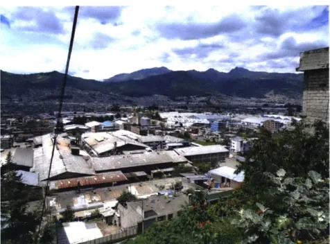
FIGURE 1. Sur de Quito
Source: Author
FIGURE 2. Norte de Quito (Barrio Quito Tenis)
- ~ ~ ~ I --i - ' W a m'AP ~'~h A 'Ak I Source: http://fotos.crminmobiliario.com.mx/cliente/151085/fotosproductos/departamento-residencial-en-venta-en-norte-de-quito-quito-10683_thumb.jpg
FIGURE 3. Norte de Quito (Bellavista)
-- 1lAp
4
1~ *1~Vu
Source: http://static.panoramio.com/photos/large/33069851.jpg
In the Global North, these spatial expressions of inequality have drawn attention as
scholars look at phenomenon such as gentrification and the suburbanization of the poor. In the
Global South, particularly as it has been positioned from the vantage of international development agencies, the dialogue on territoriality and inequality is often centered on considerations of the 'formal' and 'informal' city. Yet, this dichotomous characterization of territorial claims in the urban context is limited, particularly in cities like Quito. Territories in the city such as those of indigenous communities- whether settled in comunas6 or barrios indigenas - are outside of the formal market in that they break from the dominant matrix of (individualized) private property but are under accounted if placed in the category of
"informal". In being anchored on ancestral and identity based claims to land, these spaces are far more complex than what dominant notions of informal spaces connote and very much embedded within a formal, yet autonomous, vision of community development (and thus regulated within such a vision).
6Comunas are ancestral lands that are collectively held by indigenous community with shared identity, history, and
governance structure.
7 Indigenous neighborhoods- neighborhoods in the urban perimeter of Quito where indigenous communities from
This dominant framework is limiting too in how it directs strategies for addressing territorial inequality. In Quito, like in many other cities of the global south, a premium has been
put on programs of regularization , that is the "legalization" of informal settlements through the titling of property rights, as a primary mechanism for addressing the land concerns of poor
and historically marginalized communities. Yet, titling of property rights is not always easy to achieve nor does is it always equate to solutions for the conditions these communities face. Informal settlements can struggle to be considered eligible for regularization if they are located in areas with risky topography9 or in zones deemed for ecological protection. Moreover for
many, even with regularization, 'precarity' can continue to characterize their territorial condition- poor infrastructure access, lack of good public transit access, isolation from urban services and beyond.
These realities underscore the complexity shaping land rights, land value and land use considerations. Market centered orientations to urban development, which center land considerations on lands exchange value, have limited the ability to account for such
complexities and approach land from a more rights based perspective, particularly one that seeks to look more comprehensively at land as an enabling right.
Understanding land as an enabling right, that is as a right that helps with the fulfillment of other rights, breaks forward critical questions that can deepen our understanding of equity and territoriality: how is the land connected to a households ability to access food- can food be cultivated on the land if needed or are grocery stores, markets or other food sources easily accessible? Is the land with adequate infrastructure to ensure access to potable water, sanitation, energy? Does the land help facilitate the right to self-determination for indigenous and other historically marginalized communities?'0 That is, are the forms of land access and
8 The term regularization will be used because it most closely aligns with how the term is used in
Spanish-regularization signifies the 'legalization' of informal settlements through land titling,
9 important to critically note that this concept can be mobilized politically as well. High end developments on risky
topography are often not sanctioned
10 As stated in ILO provision 169:
management in place supporting the realization of the social, economic and cultural rights of communities with respect for their social and cultural identity, their customs and traditions and their institutions?"
To re-center considerations of land and more fully account for the conditions effecting historically marginalized communities, an analysis of the socio spatial configuration of Quito is imperative. Through this analytic we can begin to obtain a clearer picture of how territorial inequity has taken hold.
1.2 Socio Spatial Segregation in Quito
How exactly does inequality manifest in the spatial form of Quito? As in many cities, urban space and inequity intersect in complicated ways.
As stated in the onset of this chapter, one of the most evident expressions is the concentration of poor and historically marginalized communities in the peripheral zones of the city and, inversely, the concentration of wealthier residents in more centralized zones of the city. Data from the 2010 national population and housing census elaborated by the Instituto de la Ciudad (2013) demonstrates how the administrative zones of Quitumbe in the far south of Quito and Calderon in the far north of the urban core of the city, hold among the highest concentration of poor residents as measured by unsatisfied basic needs.'2 This is demonstrated in the map
below- the darker green represents higher incidence of poverty, the lighter green lower incidences of poverty. The shaded area in the center is the urban perimeter of Metropolitan District.
Article 2 of ILO Convention 169
The Unsatisfied Basic Needs methodology for measuring poverty is one used by the Ecuadorean government. It is a multidimensional poverty index
Map 1. POVERTY BY ADMINISTRATIVE ZONE
2~9%
Sourc: Intituo deLa Cidad 203
por eidns
2500-3000).
22,5%*1
LLY7'EDA
Source: Instituto de Ciudad (2013)ra
As is demonstrated in the zones indicated by a darker shade of green, 33,000-42,000 of the residents in Calderon and 18,000-25,000 in Quitumbe are considered in poverty. Other zones situated at the margins of the urban perimeter, such as the southeastern section of the administrative zone La Delicia, also experience a disproportionately higher concentration of poor residents (25,000-33,000).
This 'peripherization' of poverty in Quito becomes more acute when disaggregating the
unsatisfied basic needs measurement to look at indexes of access to basic infrastructure services and other indicators of poverty. Turubamba and Guamani- two neighborhoods in the administrative zone of Quitumbe- have among the lowest access to basic infrastructure services in comparison with other urban centers of Quito (88% and 86% respectively) as does El
Condlado in the Administrative Zone of La Delicia (at 85.1%, the lowest index of access to basic services in urban zones of Quito). In contrast, neighborhoods in the Administrative Zone of
Eugenio Espejo in center north of the Quito- such as Kennedy, Inaquito and Concepcion-predominate in list of areas with nearly 100% met needs in terms of access to basic infrastructure services (Samaniego, 2013). This pattern of inequitable dispersion of basic services is also evidenced when looking more broadly at other urban services such as access to education centers, health centers, cultural centers in beyond. The map below, elaborated by the Municipality in 2012, visualizes this- blue dots represent health centers, red dots education centers, purple dots cultural centers, yellow dots buildings of public administration, black dots banks.
Map 2. URBAN SERVICES
q. eq... 0 0. A a * .0 . 4e ~ .~ ~:'~ *... .t 4,~.. * S g. ~. 9*%h~ * a S S. tb.':d ~ S ,s .e. 5 * 7I * I * 4 * * I S 0
I
'I -4 Si #4 1 C 1AW s-x - A- .oI#b w 0d Fewft* S THV-MDMC. 2011Source: Municipio del Distrito Metropolitano de Quito (2012)
Education levels of household heads, which speaks in important ways to the social capital of communities, show a similar geographic distribution. Administrative Zones of Quitumbe and Calderon show the lowest incidence of higher education attainment by
household heads and largest concentration of household heads with only a primary level education (Instituto de la Ciudad, 2010). In contrast, the Administrative Zone Eugenio Espejo has the highest level of higher education attainment in the city and one of the highest in the county (Samaniego, 2013).
While less definitive in its indications (thus urging more caution in its interpretations) data on economic activity in the city also demonstrates uneven spatial distribution. Although only 20% of residents in the city live in the center north Administrative Zone of Eugenio Espejo, over 50% of employed residents in the Quito work in this zone- positioning it as the area with highest productive activity. In the Administrative Zones of Quitumbe and Calderon only 5% and 3% (respectively) of employed residents are concentrated, even though their populations are double and triple this amount (Instituto de la Ciudad, 2010).
A look at the manufacturing sector3- one of the two principal sources of employment in the city- similarly shows a concentration of activity in the Administrative Zone Eugenio Espejo (23% of establishments are located there) whereas zones like Quitumbe (13%) and Calderon (8%) hold a lesser share. Interestingly, visualizations of the geographic distribution of
companies in this sector evidences an agglomeration of more micro and small enterprises in the Administrative Zone of Eugenio Espejo and a more significant presence of medium and larger enterprises in the Administrative Zone Quitumbe and in the south east area of La Delicia (Instituto de la Ciudad, 2013). Map 4 below illustrates this distribution- red dots are large companies, green medium sized companies and blue small companies.
Zoning patterns in the city echo this arrangement- Administrative Zones of Quitumbe and Calderon have more areas zoned for industrial use compared to zones like Eugenio Espejo that are more zoned for residential and commercial use (See Annex 1). While a more detailed
examination is called for, critical questions should be raised on what implications this has for the quality of life of Quitumbe and Calderon residents. How is the presence of larger
manufacturing sites contaminating land, affecting air quality or creating other conditions of environmental injustice for communities residing in these zones?
I
Map 3. MANUFACTURING SITES
ESP"O ,~U e. 161 EsosLO Crv ~ M - .-E LAA .
r-Wf
toI
Ek-&CraCJ1,c -bstkt0- dB W~38-da-Source: Instituto dle Ia Ciudad (2013)
An examination of the spatial distribution of employment in service, commercial and construction sectors- where many lower income residents find occupation- would benefit this analysis and perhaps reveal a similar pattern, that key anchors of economic investment and thus opportunity are disproportionately concentrated in the center north of the city. This uneven distribution of economic activity can implicate significant mobility challenges and social costs for residents- extensive commute times and with it heavier childcare costs and
fragmentation from social networks.
While scrutinizing this socio spatial exclusion from the lens of economic measures is necessary, it is equally imperative to center how this inequity is situated along racial and ethnic lines. Mapping of racial and ethnic demographics by the Instituto de la Ciudad14 reflect how
residents who self-identify as Indigenous, Afro-Ecuadorian or Montubio are more concentrated in the extreme north and south of the city. As above indicated, these are the same areas that hold the highest concentrations of poverty, lack of infrastructure and exclusion from the city's centers of economic activity. Indicators of unemployment show a similar pattern of inequity on racial and ethnic lines- indigenous populations of Quito have the highest incidence of
unemployment at 15.7%, followed by Afro-Ecuadorians at 9.7% (Samaniego, 2013).
Yet, solely classifying socio spatial segregation in Quito as an expression of
peripherization of poverty along the urban core is inaccurate. As a metropolitan and thus more regional system of governance, Quito includes parishes that while classified still as rural are very much part of the urbanized extension of Quito and and in many ways microcosms of the socio spatial segregation documented in the urban core. Administrative Zone Tumbaco is a particularly relevant zone to draw attention to for these reasons. Tumbaco includes the suburbanized canton of Cumbaya which, with one of the areas with highest concentration of wealthy residents, is the area with lowest incidence of poverty15 in the Metropolitan District of
Quito (Samaniego, 2013). In this same Administrative District, is located the largest
1 See "Conociendo Quito: San Roque y sus areas de influencia" (Instituto de la Ciudad, 2015).
concentration of communal indigenous lands, comunas, than any other Administrative Zone in the city. Of the 20 registered comunas in Tumbaco, nearly 15 have rates of 80-100% of
poverty.'6 Map 5 below captures this dynamic- green indicates lowest incidences of poverty
(less than 20%) while red indicates the highest incidences of poverty (81%-100%). With rapid growth in the zone, significant concerns have been raised on the pressures comunas are facing,
particularly those factors threatening their fragmentation and loss of land.
I
Map 4. POVERTY IN COMUNAS
7
-it chab :n41% (,% E
E -af fr JdlCwaft
ouce Insittodela iuad(213
* As easurd by nsatified asic eeds
LEYNr A
L.LJX
'W'
Q~ui:o urbano meir
Pobreza pc,, NBE Mierior al 20% c ~ 21% Sin 1%V&! l 41% &0% n 61~ 80 .. L C, -; r; CAWP 2
jei1e
Sec~e-ar a be Coord niacoi T~ Te-rl'ia y Par tci cazid6r C ujdad ara 2012E acoac c' n Irs! ~j-- de Ia
Clidac-Source: Instituto de la Ciudad (2013)
Together, this data urges a more complicated picture of how socio spatial configuration takes hold. To more precisely understand how location situates conditions for a community, factors such as access to services, regulation of land use, ease of mobility (among other considerations) should be taken into account. A broader set of rights are connected to such considerations and speak to a vision of land use and land policy grounded in a rights to the city and buen vivir frame.
1.3 Socio Spatial Segregation in Quito: How did we get here?
What has provoked this socio spatial segregation in the city? It is important to pause and draw attention to this question as it facilitates a better understanding of dynamics that have and continue to provoke inequity in land questions in Quito.
As many studies position, to look at at spatial segregation in the Quito it is necessary to start from a historical formation of the modern city (Villarroel, 2015). While a more
comprehensive look at this question would take stock of a more expansive notion of the various periods that constitute the trajectory of urban development in Quito including Pre Colombian, Colonial and Post-Colonial periods (to more fully understand how such moments shaped conditions of land) studies writ large point to various periods of the 20th century- specifically
the beginning of the 201h century and the mid half of the century (1950s-70s) as the formative moments of the modern city. This draws parallel to key moments when modern capitalist urban development has taken hold and, for the interest of this study, driven how land use
arrangements are approached.
One of the most important observations in a historical assessment of socio spatial segregation in Quito- particularly as uplifted in the study "Origen Estructural de la Segregaci6n Especial en Quito: una hip6tesis" by Fabian Regalado Villarroel- is that alongside seeing how market dynamics have driven land use arrangements it is important to see how dynamics of racial, social and class segregation (driven by elites and institutional arrangments ) have also shaped formation of (and generally conditions in) the city as well. As Villarroel (2015) states:
"What provokes segregation in the city are not only dynamics of the market but that such dynamics, within the design of planning and development approaches, intersect with the symbolic and imagined differences that gave birth to Latin American cities" (p. 73).
The early twentieth century was a critical moment in the modern development of Quito in several major ways- Industrial development was strongly taking hold, positioning cities as important "articulators" of capital accumulation; strong surges in population growth, from migration from rural regions as well as from regional influxes, were bringing new demographic pressures; and elite notions of what constituted modernity and the urban, often underpinned by discrimantory notions of race, were driving how land use arrangements and considerations were taking hold (among other factors). For example, notions of what was considered urban and modern was contrasted with that which was considered rural and associated with
indigenous community/identity. The north inhabited by the elite of Quito was considered the modern city while areas such as Calderon, Carapungo, San Roque (which were inhabited by migrant, indigenous and urban poor) were (and some continue to be) positioned as the peripheral or semi-rural areas of the city.
The strong need for housing in this period led to a sort of 'early' phase of commodification of the housing market in the modern development of the city- more established property owners, businesses owners and the church began renting, positioning properties' as an important source of accumulation of capital. Many migrants took up residence in the centro, and this area became also became an important area of commercial activity fueled by these communities. Poorer residents who could not find housing in these more
central areas were forced to turn to housing options in the more peripheral areas of the Sur while wealthier residents migrated north, as the demographic changes in the Centro were
making the area 'undesirable' for them (Villarroel 2015).
Early city development plans cemented this socio spatial segregation. The first city plan formally regulating land use in the 1940s called for the city to segregate residential zones by
class (3 classes- working, middle and residential) and for urban development to be directed North (Carrion & Espinosa, 2012). It also called for railway workers housing to be situated in the zone adjacent to the railway, a pattern that persisted as demand for social housing near the industrial development in the Sur continued to be called for (Carrion, 1987).
The 1950s-70s marks a second period that is considered particularly formative in the modern urban development of the city. A surge in migration from campo a ciudad (rural areas to the city) fueled massive population growth in Quito- this was caused by an overall economic shift taking hold in the country (and region) as well as the failure of agrarian reform to address the needs of the rural poor (Villarroel 2015).
Simultaneously, the boom of the petroleum sector in the 1970s led to a 'boom' in infrastructure development and in the real estate market. Several research studies17 point to
this period as particularly formative to the land market as it is today- land became firmly tied to its symbolic values and instruments applied in the development of the city (such as changes in zoning, the delimitation of the urban perimeter, etc) were increasingly leveraged to add value to the price of land. Municipal policies facilitated this process- as an ease on land use
restrictions (along with other business friendly urban policies)- were critical to the growth of the construction industry in this period (Carrion & Espinosa, 2012).
The speculation that took hold exacerbated socio spatial inequities as land become increasingly inaccessible to the urban poor, forcing communities to look to the peripheries to resolve their housing needs. In the mid 1970s it is estimated that over 25% of residents in the city had to turn to secondary, informal markets to address their housing needs (Carrion, 1987), making it no surprise that this period too is when extensive growth in precarious settlements took hold. Such territorial challenges were exacerbated for poor communities as, for decades, municipal action and investment continued to concentrate in the 'modern' and 'new' Quito,
17 See Carrion (1987) and Villarroel (2015) whom evidence this through detailed looks at the evolution of rental
while in the Sur and peripheral neighborhoods communities were often forced to resolve their own needs for infrastructure and urban services.
In many ways, this period cemented the speculative practices that drove territorial development for decades and that persist to this day. Processes of urban renewal and expansion in more recent decades have reflected this as poor and historically marginalized communities continue to face displacement from more central zones of the cities. In their study on the urban form in Quito, researchers Fernando Carrion and Jaime Erazo Espinosa describe this dynamic: "In driving residents out of central areas to the outskirts of the city implies, at
least the following situations: first, in the areas of urban renewal, to intensify land use with other more profitable uses for capital and landowners; second, in the areas of expansion, to develop a land market with speculative characteristics...that benefits landlords, brokers, developers, etc., to the detriment of the population residents there" (p. 519)
A look at these formative periods in the development of Quito demonstrates that alongside speculative pressures in the land market, socio spatial segregation in the city has been shaped by (1) lack of regulation and market oriented policy regimes, (2) a systematic lack of investment and (3) underpinning discriminatory attitudes towards the urban poor (and the
indigenous, afro ecuadorean and montubio communities many of them represent) and their 'place' in the city.
CHAPTER 2: THE POLITICAL & HISTORICAL CONTEXT
While the examination of socio spatial segregation in the opening chapter seeks to make visible the way inequality is territorialized in the city, in order to adequately center the import of the territorial question a "step back" to the broader political context is necessary. How have land questions centered in the agenda/platforms of historically marginalized communities (in Quito)? What contemporary political frames inform the current dialogue on land and
development? What policy and normative shifts urge expanded and new considerations of land use and land rights? These questions are critical to understanding the forces shaping the considerations of land questions in Quito in the contemporary context.
As a brief examination of these questions demonstrate, the political context is a multi scaler one both geographically- informed by national, local and regional dynamics- and temporally- informed by contemporary as well as historical dynamics.
Together these factors constitute the parameters in which land questions are held and in important ways are representing apertures for re aligning how territorial considerations are accounted for. Why do we need to appreciate that? It is important to retain a politicization of the concept of land and land use planning. New changes in the political context, in an important
part responding to claims of historically marginalized communities, present grounding for more equitable approaches to land policymaking.
This analysis of the political context is anchored in a look at: 1) The territorial claims of Historically Marginalized communities 2) the new paradigms of Buen Vivir and Right to the City 3) Other Dimensions of the Regional context.
2.1 The Territorial Claims of Historically Marginalized communities
Land rights claims have long been a vital component of the community and political platforms of historically marginalized populations in Ecuador-particularly indigenous, afro-ecuadorean and montubio communities. This is evidenced in the founding analysis and vision as
well as evolution of some of the principal federations of the indigenous and afro Ecuadorian communities and the central place territorial reclamation holds in their positioning for self-determination, economic development and fulfillment of other social and cultural rights.
2.1.1 The Indigenous Movement
Since its inception in the mid 1980s, the Confederation of Indigenous Nationalities of Ecuador (CONAIE- La Confederacion de Nacionalidades Indigenas del Ecuador)- the principal convening body of Ecuador's indigenous communities- has placed the question of territorial
rights as a priority demand in its platform. In its 1988 proclamation of the rights of indigenous people in the country, 'Derechos Humanos y Solidaridad de los Pueblos Indigenas"18, one of the first 15 principles speaks to communities' inalienable right to land and to the responsibility to struggle for that right. The call for recognition of indigenous land rights and the equitable redistribution of land (that was called out as unjustly concentrated) became a primary and at many times the central demand the indigenous movement brought forward to the national government through massive mobilizations and direct actions in the 1990s. The historic 199019
levantamiento led by CONAIE, in fact, centered on the question of land rights.
The political mobilization of CONAIE and Ecuador's indigenous communities in this period was also transformative in advancing national dialogue on the notion of a plurinational state20, a concept enshrined in the 2008 constitution and consistently referenced in state
(national) development plans, policy and programmatic frameworks. This is significant to bring attention to as conceptualizations of plurinationality, as positioned from CONAIE and civil
18 A copy of the original document can be found at: http://www.yachana.org/earchivo/conaie/ddhh1988.pdf 19 The June 1990 levantamiento was historic in several ways: symbolic in that the year marked the 500t'
anniversary of Columbus's "discovery" of the Americas and, symbolic in that it was one of the first (and largest) indigenous uprisings in the region in that period
2 In its 1994 Political Platform, CONAIE identifies plurinacionalismo (plurinationalism) as one of its core ideological
principles (CONAIE, 1994). For the federation, plurinationalism is understood as equity, unity, respect, reciprocity and solidarity with all the nations that conform Ecuador. It recognizes the right of nationalities to their territory, to internal political administrative autonomy- that is to their process for economic, social, cultural, scientific and technological development (CONAIE, 1994).
actors, have consistently had the notion of territorial rights embedded in it. As Alberto Acosta, former president of the Constitutional Assembly and prominent academic and public analyst put it: Plurinationality is not only a passive recognition of the the diversity of communities and nationalities, it is fundamentally a public declaration to incorporate different perspectives in relation to society and nature. Plurinationality, then, must not seize to be taken alongside definitions that have to do with territory and the management of natural resources (Acosta, 2009).
Like the inclusion of Plurinacionalidad, an important set of changes in the constitutional reform of 2008- the recognition of the autonomy and territorial rights of indigenous and
ancestral communities, the recognition of the Right to the City and, the recognition of a new paradigm 'Buen Vivir' for development-all challenge entrenched notions of the state conceives development and territorial manaement. With this, critical implications for how land use and land rights should be (re) considered have emanated. The indigenous movement, led by CONAIE, was a decisive force in shaping these constitutional reforms and more broadly, in generating the political aperture for this moment of progressive political and normative transformation in the nation.
At a local level the struggle for territorial claims is actively present, two ways of which are critical to highlight here: 1) in the defense and development of the comunas in Quito and, 2) in the presence, organization and incidence of barrios indigenas (indigenous neighborhoods).
Briefly mentioned in Chapter 1, comunas, the ancestral lands of indigenous communities, represent a critical political, social and territorial structure for indigenous communities in Quito and, in many ways, have been central to these communities struggle to effectively claim a 'right to the city'. Comunas come out a history of struggle in the early 20th
century by indigenous urban communities to resist free market modernization pressures like
2 In addition to the efforts CONAIE led in the 1990s to advance the rights of indigenous communities, the movement was also a decisive force in broadly challenging corruption, neoliberal policies of the period.
the enclosures and privatizations of land and in its stead (re)claim land for its place in the collective production of identity, culture and traditions (Fundaci6n Museos de la Ciudad, 2014). Their trajectory has come with evolving recognition by the state- first through a presidential decree in 191122, when President Eloy Alforo recognized (indigenous) organizations settled in a defined territory, then in the Ley de Comunas/Law of Communes in 19373, later in the 1960s and 70s during the moments of agrarian reform and, most recently, in the 2008 constitution2 (Rayner, Morales & Simbaio Rengifo, 2015). Article 56 of the Ecuadorean constitution explicitly recognizes comunas as an important actor in the state and Article 57 guarantee's the collective rights of the comunas including their right to manage (and conserve) their land and the right to develop and exercise other forms of social and territorial organization. This is significant because it further enshrines the notion that comunas have a unique relationship with and approach to land and its management. As comuneros25 themselves have expressed, they consider these territories the base of their cultural identity, the base of their collective and community identity and the place where they practice and realize their own political, cultural, economic and spiritual systems. 26 Their notion of land use management goes beyond the traditional, market orientated approach to a deeper sense of stewardship that holds the value of land beyond its productive/financial output.
Municipal data estimates that at the time of the 1937 law there was close to 230
comunas in Quito. It is significant that close to 60 still exist in the municipality with an
One of the earliest comunas recognized in this 1911 decree was the comuna Santa Clara de Milan (near the center of Quito)
The 1937 Ley de Organizacion y Regimen de las Comunas/Law on Organization and Governance of Comunas established the first national, normative framework of protection and recognition for the comunas. For a territory to be a considered a comuna it required that: the number of inhabitants be no less than 50; that the governance structure be the "cabildo" (the assembly governance structure of comunas) and that collective goods (lands,
industry, etc) be registered. This law sought to support the "legalization/titling" of comunas and was important because it set a definitional frame for comunas that recognized collective rights and governance for comuneros (Fundaci6n Museos de la Ciudad, 2014).
There was also advancement made in recognition of comunas when in 1998 the Ecuadorean state signed onto Convention 169 of the International Labour Organization (ILO) which recognizes territorial rights of indigenous and ancestral communities, emphatically the right to self-determination/autonomy.
25 Residents of comunas
26 Propuesta de Comunas y Comunidades llalo-Lumbisi/ Proposal of the Communes and Communitis of l|alo-Lumbisi. Retrieved from: https://drive.google.com/file/d/B6wJrsxlLA__WERSRSlreUVHLTg/view
estimated 50,000 residents inhabiting them (Fundaci6n Museos de la Ciudad, 2014). Three registered comunas- Santa Clara de San Millan, Miraflores and Chilibulo Marco Pamba La Raya-are in the urban core of Quito. Others Raya-are spread through rural parishes in the outer zones of the metropolitan region of Quito. With rapidly expanding urbanization and suburbanization in these areas, the land of these communities is increasingly under pressure of speculative forces.
While an important segment of the indigenous population in Quito is tied to the comuna space and in that sense with ancestral roots in Quiteno territory, the decades long (and
continued) migration campo-ciudad is the background of many indigenous residents (or previous generations in their families). As was indicated in the Chapter 1, most of these communities are residing in the more peripheral areas of the city.
The assertion of collective identity has been important for many Indigenous residents that come into the city, as many come from the same regions and communities and the
consolidation of these social networks are an important part of livelihood strategies as an urban community (Yepez Morocho, 2014). In his study with the Runa Kawsay' indigenous community in the barrio (neighborhood) Campo Alegre in the 'Sur-oriente' (south east) sector of Quito, author Pascual Ramiro Yepez Morocho documents how when first arriving to the city, members of the community would live together in a house in the historic center of Quito, reproducing the dynamics of their community of origin. He describes the neighborhood as an important (more or less) defined territory where migrants locate themselves (Yepez Morocho, 2014). In this sense claim to neighborhood or barrio space becomes an important territorial claim in the urban realm.
As the community evolves in transforming from a tight network of support into a consolidated organizational space in the city, relationship with land and housing questions do as well. Runa Kawsay members went from purchasing a home together in the Centro Historico
2 Members of the Runa Kawsay community come from the same comuna of Gulalog Quillu Pungo in Chimborazo,
a province south of Quito. This community has been migrating to Quito since the 1960s (Yepez Morocho, 2014, p.
to working together for the acquisition of land to build their own housing/neighborhood (Yepez Morocho, 2014). In interviews with members of the Runa Kawsay community who were part of these initial efforts to find land for purchase, residents describe confronting discrimination with landowners, who would often not negotiate with them. Researcher and author Pascual Ramiro Yepez Morocho relates:
In respect of the search for land, the community members mentioned they inquired about different places in the periphery south of Quito and also in Machachi, where they found a wide expanse of land (approximately 20 hectares). They thought to buy this land, 50% for construction of housing and 50% for a community farm, but because of their status as Indians the landowners failed to make an agreement with them to
purchase the property because these owners, as mestizos, think Indians do not have the ability to buy this property and they mistrust of indigenous peoples and think they want to just invade the land (Yepez Morocho, 2014, p. 199).
This example brings to life the real barriers discrimination presents in indigenous communities engagement with the land market in the city. And, such discrimination is echoed in the
experience indigenous residents face when engaging the rental market (Yepez Morocho, 2014). The decision to collectively buy land as an indigenous organization was a way to go around
malpractices in the land market (Yepez Morocho, 2014). It also puts light on the more robust relationship to land the community seeks- as a space not only to build housing but for
sustenance, productive use and to build community more broadly.
2.1.2 The Afro Ecuadorean Movement
While to a differing and perhaps lesser degree in the Quiteho context, writ large, in important ways the Afro Ecuadorean community has also positioned territorial claims as a priority component of efforts for recognition and advancement of rights as a community. As was with indigenous communities of Ecuador, consolidated organizational spaces of the Afro-Ecuadorean community emerged strongly in the 1980-90s28 . Efforts to combat discriminatory
28 An important history of organizing in the Afro Ecuadorean community preceeded this period. The 1980s marks a
particularly important period as a turning point for when racial and cultural identity became more centralized in movement demands. While beyond the scope of this paper, for more on that history see CEDEAL (2011) and Delgado Calderon (2013)
and unjust conditions in the more rural regions of Ecuador such as Chota and Esmeraldas-where systems of concertaje29, land consolidation and lack of titles left communities essentially disenfranchised from land rights- were an important initial front of organizing as
AfroEcuadoreans weighed in fights for land reform, titling/regularization and beyond (Centro Ecuatoriano de Desarrollo y Estudios Alternativos [CEDEAL], 2011). With increased 'campo a
ciudad' migration the population of AfroEcuadoreans in Quito expanded and along with it
organizational formations of Afroquiteno civil society. "Upon arriving in Quito, they found themselves in an exclusionary, racist urban context that invisibilized the existence of the afro descendent population" (Delgado Calderon, 2013, p. 40). Much organizing was rooted in efforts to combat discrimination and advance rights with organizations like the Federaci6n de
Organizaciones y Grupos Negros de Pichincha (FOGNEP) and the Movimiento de Mujeres Negras de Quito (MOMUNE) bringing representation for Afroquiteios on such issues and helped advance attention to these concerns at the level of Municipal level (Delgado Calderon, 2013). This can be seen in District Development Plan of the Afroecuadorean Community- a comprehensive vision by civil society of the public policies needed to improve the quality of lives and the territorial, social, and economic well-being of Afroquitenos (Delgado Calderon, 2013, p. 80) -and in the later City Ordinance 021630 of 2008, where Municipal authorities made efforts to institutionalize this recognition of policies needed to address the needs of
Afroquitenos, including the need for policies to expand access to housing.
Localized efforts such as these also gave impulse to expanded political action and incidence at the national level. In both the 1998 and 2008 constitutional reform processes Afro Ecuadorean organizations like Confederaci6n Nacional Afroecuatoriana were active in
struggling for recognition of the AfroEcuadorean community as ancestral communities. This was critical as such recognition came in hand with a recognition of communities collective rights, what Calderon also identifies as essential to connecting to territorial rights: "you cannot ignore that the recognition of collective rights gave impulse to organizational and identity
29 Concertaje was an arrangement where workers lived on the land of the haciendas they worked on 30 Ordinance for the Inclusion of Afroecuadorean Community in the Metropolitan District of Quito:
http://www7.quito.gob.ec/mdmqordenanzas/Ordenanzas/ORDENANZAS%20A%C3%910S%20ANTERIORES/ORD
processes regarding rights related to the territory, territoriality and identity" (Delgado Calderon, 2013 p. 65). Article 58 of the Constitution states:
To strengthen their identity, culture, traditions and rights,
the collective rights established in the Constitution, the law and covenants, agreements, statements and other international human rights instruments are recognized of the afroecuadorean community.
Despite such normative advancements, conditions of inequity and within it territorial inequities remain for Afroquiteios. Directives outlined in Ordinance 0216 stayed as proposals rather than enacted policy (Delgado Calderon, 2013) and significant work lays ahead for expanding
recognition of ancestral territorial rights 31. Most Afroquitelos are marginalized to the peripheral neighborhoods of the city, experiencing the socio-spatial segregation described in Chapter 1.
2.2 New Paradigms: 'Buen Vivir' and Right to the City
As grounded in the introduction to this study, the 2008 constitutional reform was a deeply significant moment in the contemporary political context. A multitude of pointed changes in the new normative framework and statement of rights for the nation brought important implications for how land rights, land use and land management should be
considered. Key amendments included ones that spoke to the questions of the territorial rights of indigenous communities, the social function of land, planning. In the Table 1. below, these are highlighted.
31 One key model of Afroecuadorean ancestral land is the comarca. The comarca is a model of political, ethnic
territorial organization formed by local palenques and other organizations of Afroecuadorians, to achieve community development to which they are entitled, based on access to land tenure, to administrative organization, to ancestral management of territories and to sustainable use of natural resources in these territories. (CEDEAL, 2011)
FIGURE 4. Table of Articles in 2008 Constitution with Implications for equity centered Land Policy
ARTICLE LANGUAGE
Article 31 People are entitled to fully enjoy cities and their public spaces, under the principles of sustainability, social justice, respect for different urban cultures, and, balance between
RIGHT TO THE urban and rural areas. This right to the city is founded on the democratic management
CITY of the social and environmental aspects of property and the city through civic engagement.
Article 57 Indigenous communes, communities, peoples and nations are recognized and guaranteed, in conformity with the Constitution and human rights agreements,
RECOGNITION OF conventions, declarations and other international instruments, the following collective
INDIGENOUS rights: (Section 4) To keep ownership, without subject to a statute of limitations, of
RIGHTS + their community lands, which shall be unalienable, immune from seizure and
TERRITORIAL indivisible. These lands shall be exempt from paying fees or taxes; (Section 5) To keep
AUTONOMY ownership of ancestral lands and territories and to obtain free awarding of these lands (i.e. issuance of land titles); (Section 6) To participate in the use, usufruct,
administration and conservation of natural renewable resources located on their lands; (Section 7) To free prior informed consultation, within a reasonable period of time, on the plans and programs for prospecting, producing and marketing
nonrenewable resources located on their lands and which could have an
environmental or cultural impact on them; to participate in the profits earned from these projects and to receive compensation for social, cultural and environmental damages caused to them; (Section 9) To keep and develop their own forms of peaceful coexistence and social organization and creating and exercising authority in their legally recognized territories and ancestrally owned community lands; (Section 11) To not be displaced from their ancestral lands.
Article 3 The state's primary duties are:
(Section 5) Planning national development, eliminating poverty, and promoting
BUEN VIVIR + sustainable development and the equitable redistribution of resources and wealth to
EQUITABLE enable access to "Buen Vivir".
DEVELOPMENT (Section 6) Promoting equitable and mutually supportive development throughout the territory by building up the process of autonomies and decentralization.
Article 282 The State shall make laws for the use and access to land that must fulfill social and environmental functions. A national land fund, established by law, shall regulate
SOCIAL equitable access of small scale farmers, male and female alike, to land.
FUNCTION OF
LAND + LAND Large estate farming and land concentration is forbidden, as is the monopolization or
REFORM privatization of water and sources thereof. Source: Ecuadorean Constitution, Article 3, 31, 57, 282
These amendments are important to draw on for deliberating and defending a community driven approach to land. They also present a critical advancement in pushing forward new political frameworks for informing local and regional policy. Plurinacionalidad, which was
articulated briefly above, is one of these. Two other concepts that have been strongly drawn on and that are given special attention here for their relevance to land concerns are the concepts
of Buen Vivir and of Right to the City. Both are explicitly included in the constitution, are drawn
on in local and regional policy initiatives and, more broadly, are part of governmental and non-governmental frameworks both locally and regionally.
2.2.1 Buen Vivir
For many, Sumak Kawsai (as it is known in Kichwa) or Buen Vivir/Good Living is, beyond a solemn constitutional declaration, an opportunity to collectively build a new paradigm of development (Acosta & Martinez, 2009). Long considered part of the cosmovision of Andean indigenous communities Buen Vivir implies a series of social, economic and environmental rights and a vision of a economic regime based in solidarity and a harmonious relationship with nature (Quintero, 2009). These rights are outlined in Articles 340 to 415 of the constitution3 along with the state obligations to fulfill these rights. This is comprehensive in how it envisions what is needed to guarantee Buen Vivir, with strong directives in recognizing the need to promote land use planning that is balanced and equitable3 3 and that makes possible social and
territorial equity.3 4 This is echoed in the agenda of the National Secretary of Planning and
Development (SENPLADES), the national development plan for Buen Vivir.
Objective 2.4 of the 12 national objectives in the Plan speaks directly to strategizes to
democratize land policies through access, titling, addressing land concentration, trafficking of land and beyond (Secretaria Nacional de Planificaci6n y Desarrollo [SENPLADES], 2013). Objectives 2.4c to 2.4h delineates:
2.4c Create mechanisms to encourage and facilitate access to ownership and regulation of ownership of assets such as land, water for irrigation and goods, especially for
women and youth, and, with an emphasis on rural areas as part of a guarantee of autonomy and economic independence.
Ecuadorean Constitution, Title VI Regime of 'Buen Vivir'/Good Living
3 Ecuadorean Constitution, Article 276, Section 6