HAL Id: hal-02185558
https://hal.archives-ouvertes.fr/hal-02185558
Submitted on 16 Jul 2019
HAL is a multi-disciplinary open access
archive for the deposit and dissemination of
sci-entific research documents, whether they are
pub-lished or not. The documents may come from
teaching and research institutions in France or
abroad, or from public or private research centers.
L’archive ouverte pluridisciplinaire HAL, est
destinée au dépôt et à la diffusion de documents
scientifiques de niveau recherche, publiés ou non,
émanant des établissements d’enseignement et de
recherche français ou étrangers, des laboratoires
publics ou privés.
Deep plant-derived carbon storage in Amazonian
podzols
C. Montes, Yves Lucas, O. Pereira, Romain Achard, M. Grimaldi, A. Melfi
To cite this version:
C. Montes, Yves Lucas, O. Pereira, Romain Achard, M. Grimaldi, et al.. Deep plant-derived carbon
storage in Amazonian podzols. Biogeosciences, European Geosciences Union, 2011, 8 (1), pp.113-120.
�10.5194/bg-8-113-2011�. �hal-02185558�
www.biogeosciences.net/8/113/2011/ doi:10.5194/bg-8-113-2011
© Author(s) 2011. CC Attribution 3.0 License.
Biogeosciences
Deep plant-derived carbon storage in Amazonian podzols
C. R. Montes1, Y. Lucas2, O. J. R. Pereira1, R. Achard2,*, M. Grimaldi2, and A. J. Melfi31NUPEGEL, CENA, Universidade de S˜ao Paulo, Piracicaba, Brazil 2PROTEE, Universit´e du Sud Toulon-Var, La Garde, Toulon, France 3NUPEGEL, ESALQ, Universidade de S˜ao Paulo, Piracicaba, Brazil *now at: INERIS, Aix-en-Provence, France
Received: 22 September 2010 – Published in Biogeosciences Discuss.: 19 October 2010 Revised: 6 January 2011 – Accepted: 7 January 2011 – Published: 18 January 2011
Abstract. Equatorial podzols are soils characterized by thick sandy horizons overlying more clayey horizons. Organic matter produced in the topsoil is transferred in depth through the sandy horizons and accumulate at the transition, at a depth varying from 1 to more than 3 m, forming deep hori-zons rich in organic matter (Bh horihori-zons). Although they cover great surfaces in the equatorial zone, these soils are still poorly known. Studying podzols from Amazonia, we found out that the deep Bh horizons in poorly drained podzol areas have a thickness higher than 1 m and store unexpected amounts of carbon. The average for the studied area was 66.7 ± 5.8 kgC m−2for the deep Bh and 86.8 ± 7.1 kgC m−2 for the whole profile. Extrapolating to the podzol areas of the whole Amazonian basin has been possible thanks to digital maps, giving an order of magnitude around 13.6 ± 1.1 PgC, at least 12.3 PgC higher than previous estimates. This as-sessment should be refined by additional investigations, not only in Amazonia but in all equatorial areas where podzols have been identified. Because of the lack of knowledge on the quality and behaviour of the podzol organic matter, the question of the feedback between the climate and the equa-torial podzol carbon cycle is open.
1 Introduction
In spite of the great areas the tropical podzols cover world-wide – more than 140 000 km2in Amazonia (Bernoux et al., 2002; Batjes and Dijkshoorn, 1999) – and the fact that they have been recognized as early as 1941 (Richards, 1941), these systems are still incompletely known. Most of the
Correspondence to: C. R. Montes ([email protected])
knowledge about their genesis and dynamics comes from studies conducted in French Guyana (Boulet et al., 1982; Lu-cas et al., 1987; Veillon, 1991), Brasil (LuLu-cas et al., 1984, 1988, 1996; Chauvel et al., 1987; Dubroeucq and Volkoff, 1988, 1998; Bravard and Righi, 1989, 1990; Volkoff et al., 1990; Righi et al., 1990; Dubroeucq et al., 1991; Horbe et al., 2004; Nascimento et al., 2004; Montes et al., 2007; Patel-Sorrentino et al., 2007; Bardy et al., 2007, 2008; Fritsch et al., 2009) and Peru (Veillon and Soria-Solano, 1988). Simi-lar systems were also briefly described in Africa (Brammer, 1973; Schwartz, 1988) and in Borneo (Brabant, 1987).
These systems have been reported on both crystalline or sedimentary rocks. They can develop when soil solutions turn hyper-acidic, due to very low alkali or alkaline-earth cations in the soil solution, turning negative the alkaline re-serve (Grimaldi and Pedro, 1996) or when the soil material is sandy enough to allow the leaching of Al- and Fe-organic matter complexes, resulting in the dissolution of clay miner-als, Al-hydroxides and Fe-oxides or Fe-oxyhydroxides (Lu-cas, 2001). When initiated, the development of the sandy eluviated horizons (white sand horizons) is favoured by a positive feed-back and the podzols laterally develop at the expense of the ferralsols (Lucas et al., 1984; Lucas and Chau-vel, 1992). Where the time of evolution of such systems was sufficient, large areas of the landscape are covered by pod-zols (Dubroeucq et Volkoff, 1998). Aquifers in the white sands frequently reach the topsoil and are rich in dissolved organic matter (DOM). Measured values of dissolved organic carbon (DOC) in the literature range from 25 to 38 mg L−1 (Patel-Sorrentino et al., 2007), when the mean value at the mouth of the Rio Negro, which drains extensive podzol areas in Amazonia, is estimated around 8.5 mg L−1 (Tardy et al., 2009).
114 C. R. Montes et al.: Deep plant-derived carbon storage in Amazonian podzols The DOM moves freely through sandy materials, but
ad-sorbs on surfaces of fine minerals as clays, oxides or (oxi)-hydroxides (Davis, 1982; Kaiser and Zech, 2000). As a con-sequence, when the DOM-rich groundwater flowing in the white sands comes in a more clayey material, as the horizons immediately underlying the white sands, it leaves much of its DOM which adsorbs at the transition, forming a horizon rich in organic matter (Bh) (Lucas et al., 1996). The aquifers in the more clayey materials have a low DOC content, typically lower than 2 mg L−1(Patel-Sorrentino et al., 2007).
As a result, podzols can play an important role in global carbon dynamics. Considering the Amazonian basin, they provide approximately a tenth of the 0.13 Pg of carbon annu-ally exported to the Atlantic ocean (Tardy et al., 2009). The podzols can also store large amounts of carbon in their upper horizons and in the deep Bh horizons. In flat podzols areas, the frequently waterlogged upper horizons can present turf-like material over a thickness greater than 30 cm, the soils are then classified as histosols. The carbon stored in the podzols 0–0.3 m upper horizons was estimated around 5.5 kgC m−2 by Batjes et Dijskhoorn (1999) and 6–7 kgC m−2by Bernoux et al. (2002). The former authors distinguished the his-tosols from the podzols, evaluating the carbon stored in the 0–1 m upper horizon as 9 kgC m−2 for the podzols and 72.4 kgC m−2 for the histosols. These values, however, do not take in account possible deep Bh and are based on a small collection of studied profiles, less than 30 podzol profiles for the whole Amazonia.
Four detailed studies have considered the deep Bh hori-zons of Amazonian podzols (Lucas et al., 1984; Veillon and Soria-Solano, 1988; Veillon, 1991; Nascimento et al., 2004). As their objectives were to study the genesis and dynamics of ferralsol-podzol systems, they were conducted in relatively well-drained areas of transition between ferralsols and pod-zols. They showed that the deep podzol Bh’s had a thick-ness increasing when going from the transition towards the podzolic, marshy areas. Their maximum C content calcu-lated from the data given in the studies were 8, 15, 13 and 25 kg m−2, respectively, which suggests that marshy areas can store large quantities of carbon in depth. Existing studies in such areas, however, are scarce and limited to the upper horizons, due to the difficulties for observing deep horizons because of the collapse of the sandy material when digging or trading.
The purpose of this paper is to quantify the C content of both surficial and deep horizons of a typical podzol system located in the high Rio Negro basin and to extrapolate the ob-tained data to the whole Amazonian basin by using existing digitalized soil maps, in order to evaluate the importance of the podzol carbon reservoir at global scale.
2 Study site and methods
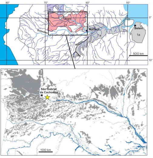
The studied area is located near the S˜ao Gabriel da Cachoeira city, Amazonia State, Brazil, at 0◦603500S, 66◦5401000W (Fig. 1); it was described in a previous publication (Montes et al., 2007). The giant podzols area has developed from a plateau centre at the expense of reddish yellow, low activity clay ferralsols; processes and dynamics of such systems are described elsewhere (Lucas et al., 1996; Cornu et al., 1998; Lucas, 2001). The soil system is typical of those observed in the Rio Negro basin (Dubroeucq and Volkoff, 1998). The climate is typically equatorial, with an annual rainfall around 3000 mm and without a marked dry season. The geological substratum is composed of crystalline rocks having composi-tion varying between monzogranitic, sienogranitic and quart-zomonzonitic (Dall’Agnol and Macambira, 1992).
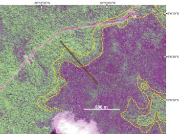
In the bad-drained, hydromorphic podzol area the water-table is usually shallow, reaching the topsoil after heavy rains. The vegetation is a specific evergreen forest called campinarana and characterized by a high density of 20–30 m height trees (Anderson, 1981). The transition between hy-dromorphic podzols and well-drained ferralsols is character-ized by better-drained podzols, forming a 100 to 200 m large halo which surrounds the poorly drained area. The vegeta-tion over both ferralsols and well drained podzols is a typical lowland Amazonian evergreen forest where dominant trees height is between 30 and 55 m. The difference of vegetation between well- and bad-drained areas is easily recognizable on remote sensing imagery (Fig. 2).
The soils were studied using a structural analysis approach (Boulet et al., 1982; Fritsch and Fitzpatrick, 1994; Delarue et al., 2009). Observations and sampling were done by hand auger drilling following a 50 m square grid and along vari-ous footpaths. A total of 164 profiles were studied, giving more than 500 samples. Due to the collapse of the sandy material when digging or trading, we have developed a light method for casing auger holes and drilling through collaps-ing E horizons and cemented Bh horizons. Auger holes were realized with an Edelman combi-type Ø 7 cm hand auger in the vadose zone. Non-cohesive water saturated sandy mate-rial was extracted using a Ø 6.3 cm Eijkelkamp valve bailer. The auger hole was cased with a Ø 7 cm PVC pipe bevelled at its end, progressively pushed down to the cemented Bh where it was pressed down by force, providing sufficient sealing to prevent fast water infiltration during drilling. The cemented part of the Bh was broken using a chisel welded to the lower end of a drill string. Soil organic C content was determined with a Shimadzu TOC-5000 apparatus. The soil densities were calculated from relationships previously established (du Gardin et al., 2002) and checked by direct measurements by the ring method. The average carbon content calculated for each identified group of horizons is a spatially weighted av-erage calculated by linear interpolation between the observa-tion points. For a given group of horizons, the given error was calculated from the propagation of the 5% error on the
Madeira Negro 2a 1a 1a 2b 5OO km 50° 60° 70° 0° 10° 80° Manaus Belem Solimões 1OO km São Gabriel da Cachoeira
Fig. 1. Situation of the studied site (yellow star) and extension of the podzol systems in Amazonia. Coloured areas in the upper map (adapted
from Martinelli et al., 1996) relate to podzol-ferralsol soil systems: 1a: clay ferralsols at the upper part of the relief units, plateau or hills, with podzols developping centripetally from the lower part of the slopes; 2a: podzols developing centrifugally from the center part of the relief units at the expense of the ferralsols; 2b: systems similar to unit 2a, where very developed podzol areas occupy the most of a flat peneplain and ferralsol remnants are restricted to flattened hills. Grey areas in the lower map relate to hydromorphic podzol areas (adapted from IBGE, 2009).
C measurement. For extrapolation calculation, the podzol ar-eas perimeters was calculated with a threshold-based pixel counting algorithm and the width of the better-drained halo has been set at 150 m. Mineralogy was determined on se-lected samples by X ray diffraction on powder samples, dif-fuse reflectance spectroscopy and thermogravimetric analy-sis.
Soil water was sampled for DOC (dissolved organic car-bon) analysis. Zero tension lysimeters were installed inside drilling holes at different depths, 2 points in the white sand at 20 and 150 cm in depth, respectively, (W-20 and W-150), one point in the Bh horizon at 230 cm in depth (W-240) and two points in the carbon-poor kaolin horizon beneath the Bh at 500 cm in depth (W-510). A spring gushing out from the center part of the podzolic area was also sampled (Spring sample). After installing the lysimeters, each drilling hole was tamped by filling with the previously extracted soil ma-terial at the corresponding depth. Each lysimeter was made
of a 50 mL polypropylene bottle bored with 5 mm diameter holes all around. A 2 mm diameter capillary PTFE tube was inserted through the bottle cap in order to permit extracting water from the topsoil with a manual vacuum pump. To pre-vent clogging of the capillary tube by soil particles, a cylin-drical filter made of a SeFar Nitex 64 µm polyamide open mesh was put inside the bottle. Saturated groundwater sam-ples were extracted and analyzed during three sampling peri-ods: 27 to 30 July 2007, 29 January 2008 to 4 February 2008 and 19 to 25 May 2008. The first period was the drier and the third one the wetter. Sampling was done applying a con-tinuous suction of 25 mmHg during a 3 to 15 mn period, de-pending on the outflow rate. The first 10 to 50 mL of each sampling, depending on the outflow rate, was discarded in order to avoid dead volume and to rinse the sampling equip-ment. Sampling was done until 250 mL was reached or air was entering the system. Each sample was filtered using a 0.7µm fiber glass filter, poisoned with sodium azide, stored
116 C. R. Montes et al.: Deep plant-derived carbon storage in Amazonian podzols 66°53'00"W 0°6'10"S 66°53'30"W 0°6'30"S 0°6'50"S 500 m
Fig. 2. View of the studied area based on Ikonos imagery. The
darker green area corresponds to closed, low forest over hydromor-phic podzols. The yellow line delineates the podzolic area, the yel-low dotted line the bad-drained podzol area. The red line situates the sequence given in Fig. 3.
in 10 mL vacuum glass flasks (Vacutainer) then kept at low temperature (around 4◦C) for laboratory DOC analysis per-formed with a Shimadzu TOC-5000 apparatus.
3 Results
3.1 Soil features and carbon content
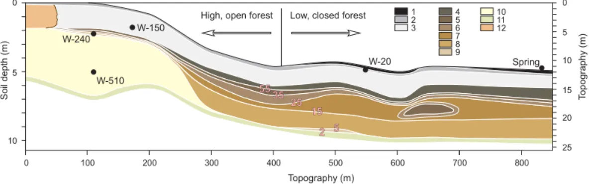
Soils in the whole area are typical of old, highly weathered soil mantle. In all horizons located over the kaolinitic sapro-lite, residual primary minerals are quartz, heavy minerals and quite small amounts of muscovite; secondary minerals are kaolinite, gibbsite, goethite and hematite. A typical soil se-quence from the edge to the centre of a podzol system is given in Fig. 3, the corresponding soil organic carbon con-tent and horizons thickness, texture and type are given in Supplementary Fig. S1 and Table S1. Bh horizons were sys-tematically observed at the transition between the white sand E horizons and the kaolinitic underlying horizons; both Bh thickness and carbon content are increasing when going from better-drained to poorly drained areas. At the transition be-tween ferralsol and podzol, the Bh horizon has a thickness around 30 to 40 cm and overlies kaolinitic horizons (more than 83% kaolinite). When going towards the poorly drained area, the Bh progressively turns thicker, up to more than 3 m. We divided the poorly drained podzol profiles in four groups of horizons: upper organic-rich, middle sandy, deep Bh and underlying saprolite.
The upper organic-rich horizons (O horizons) are dark (black 7.5YR2/1 to brownish black 7.5YR2/2 according to Munsell Color (2000). Their mineral fraction mainly con-sists of fine quartz, with small amounts of kaolinite (< 0.8%)
and Ti-oxydes. They have a thickness ranging from 10 to 40 cm, which highly depends on the local soil surface to-pography; the thickness is higher in slightly depressed areas where topsoil is waterlogged most of the time. Their C con-tents range from 16.8 to 178.0 kgC m−3, giving a total carbon content ranging from 2.5 to 41.0 kgC m−2with an average of 17.0 ± 4.0 kgC m−2.
The middle sandy horizons (white sand E horizons) are grey to light grey (10YR6/1 to 7/2). Their mineral fraction mainly consists of quartz sand (> 96%). They have a thick-ness ranging from 115 to 200 cm and present thin (< 4 mm thick) wavy black micro-horizons (thickness < 4 mm). Their C contents range from 1.9 to 3.3 kgC m−3, giving a total car-bon content ranging from 2.1 to 3.1 kgC m−2with an average of 3.1 ± 0.9 kgC m−2.
The deep Bh horizons have a thickness ranging from 220 to 340 cm and a texture varying from sandy to clayey. Their upper part, at the transition between sandy and more clayey material, is hardened over a thickness of some 20 to 40 cm. Their colour varies from black (7.5YR2/1) to brown (7.5YR5/4), the upper part is usually darker and the colour turns lighter in depth. Their mineral fraction is composed of quartz sand and kaolinite in variable proportions depend-ing on the texture, with smaller amounts of gibbsite and Fe (oxy)hydroxides. The material, however, is frequently het-erogeneous, with darker volumes of decimetrical size. Their C content ranges from 3.6 to 104.1 kgC m−3, giving a total carbon content ranging from 50.1 to 80.9 kgC m−2 with an average of 66.7 ± 5. kgC m−2. The C content values are the highest in the top 60 cm of the deep Bh horizons and decrease in depth.
The underlying kaolinitic, saprolitic material is pale yel-low to light olive gray (2.5Y8/3 to 5Y6/2). The mineral fraction is mainly kaolinitic, with fine quartz sand and mus-covite and some completely kaolinized feldspar phenocrysts. The C content values of the saprolitic material are lower than 1.8 kgC m−3.
Without considering the carbon stored in the saprolitic material, the whole podzol profiles store an average of 86.8 ± 7.1 kgC m−2 for the poorly drained area and 27.9 ± 2.5 kgC m−2for the better drained halo.
3.2 Soil water characteristics
Statistics of DOC concentration in the soil and spring wa-ters are given in Table 1. The wawa-ters from the spring and the white sand horizons (Spring, W-20 and W-150) had high DOC concentrations throughout all sampling periods, rang-ing from 24 to 55 mg L−1 with an overall average equal to 37 mg L−1. In the Bh horizon (W-240), the DOC concentra-tion varied from 12 to 19 mg L−1, 15 mg L−1on average. In the deep clayey horizons (point W-510), the DOC concen-trations were lower but not negligible, varying from 1.5 to 3.5 mg L−1, 2.3 mg L−1on average.
High, open forest W-150 Topography (m) Soil depth (m) 0 4 0 100 200 300 400 500 600 700 800
Low, closed forest
5 55 35 25 15 5 2 10 5 6 7 8 9 1 2 3 10 11 0 10 20 5 15 25 T opography (m) 12 W-240 W-510 W-20 Spring
Fig. 3. A typical soil sequence from well-drained to bad-drained podzol area. 1: upper horizons, C > 50 kg m−3; 2: upper horizons, 5 < C <50 kg m−3; 3: white sand horizons, 2.1 < C < 3.4 kg m−3; 4 to 9: Bh horizons, 3.6 < C < 104.1 kg m−3(pink numbers give C isolines in kg m−3); 10: kaolinitic horizons, C < 1.7 kg m−3; 11: kaolinitic saprolite, C < 2.1 kg m−3; 12: ferralsolic horizons, C < 1.8 kg m−3.
Table 1. DOC concentrations (in mg L−1) in the sampled waters during the three sampling periods and statistics over all periods. n: number of samples; av: average; sd: standard deviation; max: maximum; min: minimum.
July 2007 January–February 2008 May 2008 All periods
n av sd n av sd n av sd av max min Spring 3 38.7 0.3 4 42.1 3.4 4 31.8 1.9 37.4 45.4 29.0 W-20 2 45.9 13.2 4 35.9 6.0 4 26.7 1.7 34.2 55.2 24.2 W-150 1 36.5 4 37 2.6 4 42.8 7.4 39.5 52.4 34.5 W-240 4 14.2 1.6 4 16.5 1.9 4 13.2 0.7 14.6 18.9 12.4 W-510 3 1.6 0.1 3 3.0 0.4 2.3 3.5 1.5 4 Discussion 4.1 Bh genesis
The Bh features and the DOC values of the percolating wa-ters confirmed the podzolic processes acting in the studied soil cover. Bh horizons underlying podzolic E horizons are also characteristics of boreal and temperate podzols. What is new here is the thickness and the overall C content of the Bh, which indicates that unusually large quantities of DOC were transferred from the topsoil to the depth. This can be related to four main factors: (i) higher DOC concentration in the groundwater transferred from topsoil to depth, (ii) higher volumes of water transferred in depth, (iii) quality of the or-ganic matter, with a higher resistance to mineralization, and (iv) long time of evolution.
The DOC concentration in the groundwater circulating in E horizons is of the same order of magnitude than in boreal or temperate podzols (Mossin et al., 2002; Lindroos et al., 2008).
The DOC annually produced at the topsoil and transferred in the E horizons groundwater (DOCy)is given by Eq. (1),
where P is the rainfall (mm y−1), ET the evapotranspiration (mm y−1)and DOCE the DOC concentration in the white
sand E horizons (mg L−1):
DOCy=(P −ET)(DOCE)10−3 (1)
The present-day values of the parameters of the second mem-ber of this equation can be estimated from the literature and the present study: 3000 mm y−1 for P (Silva et al.,
1977), 1500 mm y−1 for ET (Leopoldo et al., 1987) and
37 mg L−1for DOCE(this study). Using these values, DOCy
is 55.5 g m−2y−1, which is more than 10 time higher than the DOC transferred at 40 cm in depth in boreal podzols (Lin-droos et al., 2008). This higher value is mainly linked to higher annual rainfall.
The DOC annually transferred and retained in the Bh (OMy, in gC m−2y−1) is given by Eq. (2), where DOCS
is the DOC concentration in the saprolite (mg L−1)and rdp
the ratio of non-evapotranspired water entering the saprolite, which corresponds to the baseflow:
OMy=(P −ET)(DOCE−DOCS)rdp10−3 (2)
From this study, DOCScan be estimated as 2.3 mg L−1. The
value of rdpis more difficult to evaluate. Tardy et al. (2009)
calculated 0.216 and 0.193 for the Rio Negro and the Rio Juta´ı basins, respectively. Since there are no podzol sys-tems in the watershed of the latter, that the slope index of
118 C. R. Montes et al.: Deep plant-derived carbon storage in Amazonian podzols the Rio Juta´ı basin is close to the one of Rio Negro and
that the hydromorphic podzols occupy 21% of the Rio Ne-gro watershed, we calculated 0.303 for rdp in the podzol
area, which corresponds to 455 mm of groundwater perco-lating annually through the Bh. Using these values, OMyis
16.8 gC m−2y−1. With the hypothesis that the organic mat-ter retained in the Bh horizons does not suffer any posmat-terior mineralization, it would last 4044 y to accumulate the aver-age 68 kgC m−2nowadays observed in the deep Bh. Such a value is evidently lower than the actual value, because part of the adsorbed organic matter is likely to be lost due to min-eralization. A Bh genesis model thus must consider one or more mineralization rates. Those are still unknown and need further investigations, but to give an order of magnitude the calculation was performed using a single type organic mat-ter, a first order mineralization reaction and a rate constant equal to 2.5 10−4y−1, calculated by considering 2800 y as
the half-life of Bh organic matter. This half-life was chosen in order to obtain an average age for the Bh organic-matter around 2000 y, in coherence with the few existing Amazo-nian Bh datations (Bravard and Righi, 1990). Which such hypothesis, it would last 30 ky to accumulate 68 kgC m−2in a Bh under the present day conditions.
4.2 Extrapolation to the Amazonian basin
The deep carbon, as well as most of the carbon stored in the organic-rich upper horizons, was not considered in stud-ies dealing with the quantification of Amazonian soil carbon (Batjes and Dijkshoorn, 1999; Bernoux et al., 2002; Cerri et al., 2007). Nevertheless, wherever a detailed study of Ama-zonian podzols has been achieved, the presence of deep Bh has been attested, so we may assume deep carbon storage in every podzol area. The quantification we made from a sin-gle area must obviously be refined throughout Amazonia and moreover throughout other equatorial podzol areas, particu-larly in the Kalimantan (Brabant, 1987), in Congo (Schwartz, 1988) and in Zambia (Brammer, 1973). Extrapolation of our data across Amazonia can, however, give an order of magni-tude of the carbon stored in Amazonian podzols.
Existing IBGE digitalized soil maps of Amazonia (IBGE, 2009) were made mainly from radar surveys (RADAMBRASIL, 1978) quite sensitive to the physical characteristics of roughness, slope and moisture on the soil surface, so that the large flat, poorly-drained podzols areas have been identified with certainty. The poorly drained pod-zol area we calculated from IBGE maps is 1 554 105 km2 (lower map of Fig. 1). Extrapolating the data of our detailed study, we calculated the carbon stored in the Amazonian pod-zols to be 13.6 ± 1.1 PgC, more than 12.3 PgC higher than previous estimates (1 PgC for the topsoil 0–30 cm after Bat-jes and Dijkshoorn, 1999 or 1.3 PgC for the topsoil 0–1 m af-ter Bernoux et al., 2002). This calculated value is certainly an underestimate, given that soil systems that include podzols, but where podzols are fragmented into small areas that do not
appear in digitalized soil maps, cover areas around 8105 km2 as calculated from RADAM maps (unit 1a on Fig. 1) .
In comparison, the total amount of carbon stored in the aerial biomass of the Amazonian forest was estimated as 93 ± 23 PgC (Malhi et al., 2006).
4.3 Lability of the podzol organic matter
Is the carbon stored in the deep Bh likely to quickly return to the atmosphere if the climate changes? Most podzol ar-eas are situated in the high Rio Negro basin. For this area, 18 different global warming climate models give projections on both precipitation and soil moisture (Meehl et al., 2007). All of those predict an increase of the average air temper-ature, seven a diminution of the annual precipitation, ten a diminution of the average soil moisture and eight an in-crease of contrast between the wet and dry seasons. Consec-utive changes of temperature and dynamics of the water-table could destabilize the organic matter of the upper horizons as well as of the deep, resulting in a complete or partial min-eralization. In temperate podzols, organic horizons with rel-atively short turnover times could be particularly vulnerable to changes in climate or other disturbances (Schulze and al., 2009). Deep Bh from the Manaus area gave two apparent
14C ages, 490 ± 90 and 2840 ± 90 y BP (Bravard and Righi,
1990), which is young when considering the potential age of the podzols. Some tropical podzols from Congo that were formed in the past and which are nowadays under a drier cli-mate keep up thick deep Bh apparently rich in organic mat-ter (Schwartz, 1988), but there is no comparison available between still hydromorphic and currently well-drained pod-zols.
As it is difficult to conclude about the sensibility of the deep Bh organic matter to climate change, some complemen-tary studies similar to those realized for northern peatland or-ganic matter (Dorrepaal et al., 2009) are needed to evaluate the feedback between the podzols carbon cycle and climate.
5 Conclusions
The studied hydromorphic podzols from the high Rio Negro exhibited thick Bh horizons at depth. The carbon stored in the podzols was on average 66.7 ± 5.8 kgC m−2for the deep Bh and 86.8 ± 7.1 kgC m−2for the whole profile. The
gene-sis of the deep Bh is likely due to high volumes of DOC-rich groundwater percolating in depth as well as a sufficient time of evolution and a sufficient stability of the adsorbed OM. As the OM saturates the minerals exchange sites, the dissolved organic matter is able to percolate more in depth, resulting in an increase of the Bh thickness. The dynamics of Bh forma-tion, however, need to be better assessed.
Extrapolation of the obtained results to the whole Amazo-nia gave 13.6 ± 1.1 PgC for the carbon stored in hydromor-phic podzols, which is at least 12.3 PgC higher than previous
estimates. This value is likely an underestimate, because soil systems where podzols are fragmented into small areas were not taken in account in the quantification. This quantification has thus to be refined by additional investigations, not only in Amazonia but in all equatorial areas where podzols have been identified.
Considering the volume of carbon stored in the podzol Bh, the stability of the Bh organic matter in a context of climate change needs to be assessed. Because of the lack of knowl-edge on the quality and behaviour of the podzol organic mat-ter, the question of the feedback between the climate and the equatorial podzol carbon cycle is open.
Supplementary material related to this article is available online at:
http://www.biogeosciences.net/8/113/2011/ bg-8-113-2011-supplement.pdf.
Acknowledgements. This work was funded by grants from
Brazil-ian FAPESP and CNPq, French-BrazilBrazil-ian CAPES-COFECUB exchange program and French ARCUS (joint program from R´egion PACA and French Ministry of Foreign Affairs).
Edited by: S. Bouillon
References
Anderson, A. B.: White-sand vegetation of Brazilian Amazonia, Biotropica, 13, 199–210, 1981.
Bardy, M., Bonhomme, C., Fritsch, E., Maquet, J., Hajjar, R., Al-lard, T., Derenne, S., and Calas, G.: Al speciation in tropical pod-zols of the upper Amazon Basin: A solid-state 27Al MAS and MQMAS NMR study, Geochim. Cosmochim. Ac., 71, 3211– 3222, 2007.
Bardy, M., Fritsch, E., Derenne, S., Allard, T., do Nascimento, N. R., and Bueno, G. T.: Micromorphology and spectroscopic char-acteristics of organic matter in waterlogged podzols of the upper Amazon basin, Geoderma, 145, 222–230, 2008.
Batjes, N. H. and Dijkshoorn, J. A.: Carbon and nitrogen stocks in the soils of the Amazon Region, Geoderma, 89, 273–286, 1999. Bernoux, M., Carvalho, M. C. S., Volkoff, B., and Cerri, C. C.:
Brazil’s soil carbon stocks, Soil Sci. Soc. Am. J., 66, 888–896, 2002.
Boulet, R., Chauvel, A., Humbel, F. X., and Lucas, Y.: Analyse structurale et cartographie en p´edologie. I- Prise en compte de l’organisation bidimensionnelle de la couverture p´edologique: les ´etudes de topos´equences et leurs principaux apports `a la con-naissance des sols, Cah. ORSTOM, s´er. P´edol, XIX, 309–321, 1982.
Brabant, P.: La r´epartition des podzols `a Kalimantan (Ile de Born´eo), in: Podzols et Podzolisation, INRA, Paris, 13–24, 1987. Brammer, H: Podzols in Zambia, Geoderma, 10, 249–260, 1973. Bravard, S. and Righi, D.: Geochemical differences in an
oxisol-spodosol toposequence of Amazonia (Brazil), Geoderma, 44, 29–42, 1989.
Bravard, S. and Righi, D.: Podzols in Amazonia, Catena, 17, 461– 475, 1990.
Cerri, C. E. P., Easter, M., Paustian, K., Killian, K., Coleman, K., Bernoux, M., Falloon, P., Powlson, D. S., Batjes, N. H., Milne,E., and Cerri,C. C.: Predicted soil organic carbon stocks and changes in the Brazilian Amazon between 2000 and 2030, Agric. Ecosyst. Environ., 122, 58–72, 2007.
Chauvel , A., Lucas, Y., and Boulet, R.: On the genesis of the soil mantle of the region of Manaus, Central Amazonia, Brazil, Ex-perientia, 43, 234–241, 1987.
Cornu, S., Lucas, Y., Ambrosi, J. P., and Desjardins, T.: Transfer of dissolved Al, Fe and Si in two amazonian forest environment in Brazil. Eur. J. Soil Sci., 49, 377–384, 1998.
Dall’Agnol, R. and Macambira, M. J. B.: Titanita biotita granitos do baixo Rio Uaup´es, Provncia Rio Negro, Amazonas. Parte 1: Geologia, petrografia e geocronologia. Rev. Bras. Geocienc., 22, 3–14, 1992.
Davis, J. A.: Adsorption of natural dissolved organic matter at the oxide/water interface, Geochim. Cosmochim. Acta, 46, 2381– 2393, 1982.
Delarue, F., Cornu, S., Daroussin, J., Salvador-Blanes, S., Bouren-nane, H., Albric, P., Vennink, A., Bruand, A., and King, D.: 3-D representation of soil distribution: An approach for understand-ing pedogenesis, Comptes Rendus Geosciences, 341, 486–494, 2009
Dorrepaal, E., Toet, S., van Logtestijn, R. S. P., Swart, E., van de Weg, M. J., Callaghan, T. V., and Aerts, R.: Carbon respiration from subsurface peat accelerated by climate warming in the sub-arctic, Nature, 460, 616–619, 2009.
Dubroeucq, D. and Volkoff, B.: Evolution des couvertures p´edologiques sableuses `a podzols g´eants d’Amazonie (Bassin du Haut Rio Negro), Cah. ORSTOM, s´er. P´edol., 24, 191–214, 1988.
Dubroeucq, D., Volkoff, B., and P´edro, G.: La couverture p´edologique du Bouclier du Nord de l’Amazonie (bassin du Haut Rio Negro), S´equence ´evolutive des sols et son rˆole dans l’aplanissement g´en´eralis´e des zones tropicales perhumides, C . R. Acad. Sci., Paris, Ser. IIA, 312, 663–671, 1991.
Dubroeucq, D. and Volkoff, B.: From oxisols to spodosols and histosols: evolution of the soil mantles in the Rio Negro Basin (Amazonia), Catena, 32, 245–280, 1998.
Fritsch, E. and Fitzpatrick, R. W.: Interpretation of soil features produced by ancient and modern processes in degraded land-scapes, I, A new method for constructing conceptual soil-water-landscape models, Austr. J. Soil Res., 32, 889–907, 1994. Fritsch, E., Allard, T., Benedetti, M. F., Bardy, M., do Nascimento,
N. R., Li, Y., and Calas, G.: Organic complexation and translo-cation of ferric iron in podzols of the Negro River watershed. Separation of secondary Fe species from Al species, Geochim. Cosmochim. Acta, 73, 1813–1825, 2009.
du Gardin, B., Grimaldi, M., and Lucas, Y.: Effets de la d´eshydratation sur les sols du syst`eme ferralsol-podzols d’Amazonie centrale. Reconstitution de la courbe de d´esorption d’eau `a partir de la porosim´etrie au mercure, Bull. Soc. G´eol. France, 173, 19–34, 2002.
Grimaldi, C. and Pedro, G.: Importance de l’hydrolyse acide dans les syst`emes p´edologiques des r´egions tropicales humides. Rˆole de la forˆet et cons´equences sur la gen`ese des sables blancs tropi-caux, C. R. Acad. Sci. Ser. lla, 323, 483–492, 1996.
Horbe, A. M. C., Horbe, M. A., and Suguio, K.: Tropical Spodosols in northeastern Amazonas State, Brazil, Geoderma, 119, 55–68,
120 C. R. Montes et al.: Deep plant-derived carbon storage in Amazonian podzols 2004.
IBGE: Levantamento pedol´ogico, folhas NA-19, NA-20, SA-19 e SA-20, CREN-IBGE, S˜ao Paulo, 2009.
Kaiser, K. and Zech, W.: Dissolved organic matter sorption by min-eral constituents of subsoil clay fractions, J. Plant Nutr. Soil Sci., 163, 531–535, 2000.
Leopoldo, P. R., Franken, W., Salati, E., and Ribeiro, M. N.: Toward a water balance in the Central Amazonian region, Experientia, 43, 222–233, 1987.
Lindroos, A. J., Derome, J., Mustaj¨arvi, K., N¨ojd, P., Beuker, E., and Helmisaari, H. S.: Fluxes of dissolved organic carbon in stand throughfall and percolation water in 12 boreal coniferous stands on mineral soils in Finland, Boreal Environment Research 13, Suppl. B, 22–34, 2008.
Lucas, Y.: The role of the plants in controlling rates and products of weathering: importance of the biological pumping, Ann. Rev. Earth Planet. Sci., 29, 135–163, 2001.
Lucas, Y., Chauvel, A., Boulet, R., Ranzani, G., and Scatolini, F.: Transic¸˜ao latossolos-podzois sobre a formac¸˜ao Barreiras na regi˜ao de Manaus, Amazˆonia, Rev. Bras. Cienc. Solo 8, 325– 335, 1984.
Lucas, Y., Boulet, R., and Chauvel, A.: Intervention simultan´ee des ph´enom`enes d’enfoncement vertical et de transformation lat´erale dans la mise en place de syst`emes de sols de la zone tropi-cale humide. Cas des syst`emes sols ferrallitiques – podzols de l’Amazonie Br´esilienne, C. R. Acad. Sci. Paris, Ser. lla, 306, 1395–1400, 1988.
Lucas, Y. and Chauvel, A.: Soil formation in tropically weathered terrains, in: Regolith exploration geochemistry in tropical and subtropical terrains, edited by: C. R. M. Butt and H. Zeegers, El-sevier, Amsterdam – London – New-York – Tokyo, 57–77, 1992. Lucas, Y., Nahon, D., Cornu, S., and Eyrolle, F.: Gen`ese et fonc-tionnement des sols en milieu ´equatorial, C . R. Acad. Sci. Paris Ser. IIa, 322, 1–16, 1996.
Malhi, Y., Roberts, J. T., Betts, R. A., Killeen, T. J., Li, W., and No-bre, C. A.: The regional variation of aboveground live biomass in old-growth Amazonian forests, Glob. Change Biol., 12, 1107– 1138, 2006.
Martinelli, L. A., Lucas, Y., Cerri, C. C., and Victoria, R. L.: Os solos da Amazonia: distribuic¸˜ao e alterac¸˜oes pelo uso da terra, in: Conferˆencia Internacional Uma Estrategia Latino-Americana para a Amazonia, Editora USP, S˜ao Paulo, 209–226, 1996. Meehl, G. A., Stocker, T. F., Collins, W. D., Friedlingstein, P., Gaye,
A. T., Gregory, J. M., Kitoh, A., Knutti, R., Murphy, J. M., Noda, A., Raper, S. C. B., Watterson, I. G., Weaver, A. J., and Zhao, Z. C.: in: Climate Change 2007: The Physical Science Basis, edited by: Solomon, S., Qin, D., Manning, M., Chen, Z., Marquis, M., Averyt, K. B., Tignor, M., and Miller, H. L., Cambridge Univer-sity Press, 2007.
Montes, C. R., Lucas, Y., Melfi, A. J., and Ishida, D. A.: Syst`emes sols ferrallitiques–podzols et gen`ese des kaolins, C. R. Geosci., 339, 50–56, 2007.
Mossin, L., Mortensen, M., and Nørnberg, P.: Imogolite related to podzolization processes in Danish podzols, Geoderma, 109, 103–116, 2002.
Munsell Color: Munsell soil color charts, revised edition, Munsell Color/GretagMacBeth, New York, 2000.
Nascimento, N. R., Bueno, G. T., Fritsch, E., Herbillon, A. J., Al-lard, T., Melfi, A., Astolfo, R., Boucher, H., and Li, Y.: Pod-zolization as a deferralitization process: a study of an Acrisol-Podzol sequence derived from Palaeozoic sandstones in the northern upper Amazon Basin, Eur. J. Soil Sci., 55, 523–538, 2004.
Patel-Sorrentino, N., Lucas, Y., Eyrolles, F., and Melfi, A. J.: Fe, Al and Si species and organic matter leached off a ferrallitic and podzolic soil system from Central Amazonia, Geoderma, 137, 444–454, 2007.
RADAMBRASIL: Levantamento de Recursos Naturais, 18, Min-ist´erio de Minas e Energia, Rio de Janeiro, 623 pp., 1978. Richards, P. W.: Lowland tropical podzols and their vegetation,
Na-ture, 148, 129–131, 1941.
Righi, D., Bravard, S., Chauvel, A., Ranger, J., and Robert, M.: In situ study of soil processes in an oxisol-spodosol sequence of Amazonia (Brazil), Soil Sci., 150, 438–445, 1990.
Schulze, K., Borken, W., Muhr, J., and Matzner, E.: Stock, turnover time and accumulation of organic matter in bulk and density frac-tions of a Podzol soil, Eur. J. Soil Sci., 60, 567–577, 2009. Schwartz, D.: Some podzols on Bateke sands and their origins,
Peo-ple’s Republic of Congo, Geoderma, 43, 229–247, 1988. Silva, F. C. F., Jesus, R. M., and Ribeiro, A. G.: Vegetac¸˜ao, in:
Projeto RADAM BRASIL, Folha SA. 19 Ic¸´a, Levantamento de Recursos Naturais 14, Minist´erio de Minas e Energia, Rio de Janeiro, 297–396, 1977.
Tardy, Y., Roquin, C., Bustillo, V., Moreira, M., Martinelli, L. A., and Victoria, R.: Carbon and Water Cycles Amazon River Basin Applied Biogeochemistry, Atlantica, Biarritz, 2009.
Veillon, L.: Sols ferrallitiques et podzols en Guyane Septentri-onale. Relations entre syst`emes de transformations p´edologiques et ´evolution historique d’un milieu tropical humide et forestier, Travaux et Documents Microfilm´es, 76, ORSTOM, Paris, 266 pp., 1991.
Veillon, L. and Soria-Solano, B.: Transition sol ferrallitique - pod-zol: cas d’une terrasse s´edimentaire de l’Ucayali (Perou), Cah. ORSTOM, s´er. P´edol., 24, 97–113, 1988.
Volkoff, B., Mortatti, J., and Cerri, C. C.: Rˆole des nappes dans les diff´erenciations p´edologiques des zones `a podzols de l’Amazonie, C . R. Acad. Sci. Ser. IIa, 310, 1361–1368, 1990.