HAL Id: tel-02600299
https://hal.inrae.fr/tel-02600299
Submitted on 16 May 2020
HAL is a multi-disciplinary open access
archive for the deposit and dissemination of sci-entific research documents, whether they are pub-lished or not. The documents may come from teaching and research institutions in France or abroad, or from public or private research centers.
L’archive ouverte pluridisciplinaire HAL, est destinée au dépôt et à la diffusion de documents scientifiques de niveau recherche, publiés ou non, émanant des établissements d’enseignement et de recherche français ou étrangers, des laboratoires publics ou privés.
The potential impact of Forest Fire on the occurrence of
Mass Movements in Damour watershed under climatic
variations and land use change
R. Ziade
To cite this version:
R. Ziade. The potential impact of Forest Fire on the occurrence of Mass Movements in Damour watershed under climatic variations and land use change. Environmental Sciences. 2014. English. �tel-02600299�
2 ACKNOWLEGMENTS
First of all, I am grateful for my family who has put up with me for last
four years especially my husband Georges.
I wish to express my thanks to Dr. Nicolas Baghdadi for welcoming me
in the Maison de la Teledetection in Montpellier and providing me with
all the necessary facilities during my stay there as a student in
co-advisory.
I place on record my gratitude to Dr. Chadi Abdallah for signing me up
for this PhD and for his assistance and guidance throughout this thesis.
I would also like to thank the members of my steering committees (Dr.
Dr. Jean-Stéphane Bailly, Dr. Frederic Berger, Dr. Olivier Cerdan, Dr.
Yves Lebissonet, Dr. Roger Moussa) for their constructive remarks and
suggestions.
And to Mr. Pierre-Yves Vion, thank you for the help in all the
administrative paperwork and processes, your assistance was very
indispensable.
3 DEDICATION
I dedicate this thesis to my daughter Yasmine and my husband Georges.
May this thesis be a new start for us.
4 Résumé de thèse en Français
Les Mouvements en Masse (MM) présentent un risque naturel majeur menaçant les milieux naturels et humains au Liban. Survenant sous diverses formes et requérant un large éventail de techniques de télédétection, de modélisation et de zonage pour leur analyse et suivi, l’occurrence des MM est surtout influencée par des facteurs de pré-conditionnement et induisant tels que les incendies de forêt (IF) qui ont dû contribuer à la destruction de plus de 22% des forêts du Liban en moins de 50 ans. Cette thèse étudie l'impact des IF sur l’occurrence des MM dans un contexte de changement climatique et de conversion accrue des modes d'occupation des sols. Après la normalisation des facteurs de pré-conditionnement, la gravité des brûlures des IF est représentée par le Rapport de Brulure Normalisé (RBN) à l'aide du système d'information géographique (SIG). Le facteur de pondération (FP) de chaque couche est évalué en utilisant la méthode InfoVal modifiée. Une Carte de Susceptibilité aux MM (CSMM) est générée et validée par un groupe indépendant de MM. Précédé seulement par le type de sol, la gravité des brûlures des IF a obtenu le deuxième plus haut FP. Une enquête plus approfondie sur les facteurs de génération des IF a aussi été réalisée. Les facteurs climatiques provoquant la prolongation de la sécheresse ont été analysés à travers de l’Index de Reconnaissance de de Sécheresse (IRS), et l'utilisation des sols a été évaluée via l’Indice de Végétation Normalisée par Différence (IVND). Les associations entre RBN et IRS et RBN et IVND indiquent que le RNB est le résultat de l'interaction entre le climat et l'utilisation des sols.
Titre de la Thèse en Anglais
The potential impact of Forest Fire on the occurrence of Mass Movements in Damour watershed under climatic variations and land-use change
Résumé de thèse en Anglais
Mass movement (MM) is a major natural hazard that threatens natural and human environments in Lebanon. It comes under various forms needing a wide range of MM detection, modeling and zoning techniques. MM occurrence is influenced by preconditioning factors and inducing factors such as forest fires. Since the latter has emerged as another hazard destroying over 22% of Lebanon's forests in less than 50 years, this thesis investigates impact of forest fire on MM occurrence under climatic variations and land-use change. Following the standardization of the preconditioning factors in addition to the forest fire burn severity out of the Normalized Burn Ratio (NBR) into layers using geographic information systems (GIS), the Weight factor (Wf) of each was evaluated using the modified InfoVal method. A MM susceptibility map (MMSM) was
5 generated and validated by an independent set of MM. Preceded only by soil type; forest fire burn severity obtained the second-highest Wf. Further investigation into forest fire generating factors was performed. Climatic factors causing prolonged droughts were observed using a meteorological Reconnaissance Drought Index (RDI) and land-use was assessed using Normalized Difference Vegetation index (NDVI) .The associations between NBR and RDI and NBR and NDVI indicate that NBR is a result of the interaction between climate and land-use.
6 Abstract
Mass movements such as landslides, earth flows, block falls and erosion are among the most invasive hazards in the Mediterranean basin, causing surface instability favorable to land degradation threatening the natural and human environments. In Lebanon, the occurrence of MM has increased by almost 60% between 1956- 2008. Similarly, forest fire has emerged as another hazard and has destroyed over 25% of Lebanon's forests in less than 40 years. Although both hazards affect vast areas of the Lebanese territories, the impact of forest fire on MM occurrence has not been studied yet and corresponding MM susceptibility maps are still lacking. This research deals with the use of remote sensing and GIS in assessing the impact of Forest fire burn severity on MM occurrence in Damour watershed.
In this context, the first part reviews existing knowledge on the topic of MM and defines research gaps. It displays MM classifications, preconditioning and inducing factors and their corresponding impact on MM. Furthermore, the efficiency of land stability detection and zonation remote sensing methods were compared pointing out possible ways of research
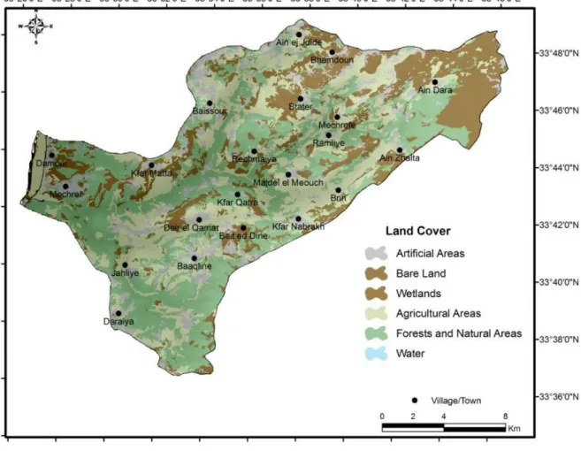
The second part studies in depth the study area of Damour watershed. Geomorphology, geology, soil and land use characteristics were explained as well as natural hazards that are already occurring in the study area. The study area, extending from the Mediterranean coast to around 2000m of elevation covering almost 3.7% of the total area of Lebanon.
The third part investigates the potential effect of forest fire on the occurrence of mass movement in the Damour watershed. Mass movement and forest fire inventory maps were produced through remote sensing (RS) using aerial and satellite images. Forest fire was introduced as the inducing factor whose effect was extracted from Landsat images through the normalized burn ratio (NBR) index. A field study was conducted to substantiate the mass movement inventory and Normalized Burn Ratio maps. Following the standaRDIstzation of the effect factors into layers using geographic information systems (GIS), the weight factor of each layer for inducing mass movement was evaluated using the modified InfoVal method, and an mass movement susceptibility map (MMSM) was generated. Preceded only by changes in land use, the NBR obtained the highest weight, making forest fire burn severity the second-highest impacting factor on mass movement occurrence in the study areas.
The fourth part is dedicated to conclude whether forest fire burn severity; one of the main MM occurrence inducing factors, is driven by climatic variations or land use changes. Climatic factors causing prolonged droughts are observed using the Standardized Reconnaissance Drought Index
7 (RDIst). On the other hand, understanding the role of land use in shaping wildfire regimes was
achieved using Normalized Difference Vegetation Index (NDVI). The spatiotemporal changes in forest fire burn severity tracing the yearly burned severity patterns was compared with corresponding climatic and land use patterns respectively in order to establish a individual correlations. It was synthesized that the association indicates that climatic variables and anthropogenic factors simultaneously affect forest fire burn severity rather than it being the product of a sole factor.
The fifth part displays a general conclusion of the research findings in addition to stating the study setbacks which can be furetheron addressed to enhance results accuracy. Furthermore, recommendations for MM and forest fire adaptive measurements have been suggested in oreder to improve study area resilience to these destructive natural hazards .
Keywords: Mass Movement (MM), Forest fire, LANDSAT satellite images, Normalized Burn Ratio (NBR), Information Value Method (InfoVal), Mass Movement Susceptibility Map (MMSM), Standardized Reconnaissance drought Index (RDIst), Normalized Difference Vegetation Index (NDVI).
8 Résumé
Les mouvements en masse (MM) tels que les glissements de terrain, coulées de boue, chutes de blocs et érosion du sol sont parmi les dangers les plus répandus dans le bassin méditerranéen, entraînant une instabilité de surface favorable à la dégradation des sols et menaçant les environnements naturels et humains. Au Liban, la fréquence des MM a augmenté de près de 60% entre 1956 et 2008 engendrant entre autre des incendies de forêts (IF) - danger supplémentaire qui a dû détruire plus de 25% des forêts du Liban en moins de 40 ans. Bien que les deux risques affectent de vastes zones du territoire Libanais, l'impact des IF sur l’occurrence des MM n'a pas encore été analysé préalablement et les cartes de sensibilité aux MM demeurent toujours en défaut. Cette recherche utilise la télédétection et les techniques de système d'information géographique (SIG) dans l'évaluation de l'impact de la gravité des brûlures des IF sur la fréquence des MM dans le bassin versant du Damour.
Dans ce contexte, la première partie passe en revue sur les connaissances actuelles autour du sujet de MM et identifie les lacunes de la recherche. Elle définit les classifications des MM, leurs facteurs de pré-conditionnant et induisant, et leur impact sur les MM. En outre, l'efficacité de détection de la stabilité des sols et le zonage des méthodes de télédétection sont comparées, indiquant les voies possibles de recherche.
La deuxième partie évalue en profondeur les caractéristiques de la géomorphologie, la géologie, et l’utilisation des sols de la zone d'étude. Les catastrophes naturelles qui se produisent dans la zone d'étude qui s'étend de la côte méditerranéenne à environ 2000 m d'altitude couvrant près de 3,7% de la superficie totale du Liban sont aussi expliquées.
La troisième partie examine l'effet potentiel des incendies de forêt sur la fréquence des MM. Une carte d'inventaire des MM et des incendies de forêt sont produites par télédétection (RS) en utilisant des images satellitaires et aériennes. Les IF sont présentés comme facteur induisant dont l'effet a été extrait à partir d’images Landsat par le Rapport de Brûlure Normalisée (RBN). Une étude de terrain est menée à l'appui de cartes d'inventaires de MM et RBN. Après la normalisation des facteurs pré-conditionnant et induisant en couches à l'aide du SIG, le facteur de pondération (FP) de chaque couche pour induire un MM a été évalué en utilisant la méthode InfoVal modifié, et une Carte de Sensibilité de MM (CSMM) est générée. Précédé seulement par des changements du type de sol; la RBN a obtenu le deuxième plus haut FP qui impacte l'apparition de MM dans la zone d'étude.
La quatrième partie est consacrée à déterminer si la gravité des brûlures des incendies de forêt, l'un des principaux facteurs induisant l’occurrence MM, est entraînée par les variations
9 climatiques ou le changement des modes d’utilisation des sols. Les facteurs climatiques qui provoquent la prolongation de la sécheresse sont observés en utilisant l’Indice de Reconnaissance météorologique de Sécheresse (IRS). D'autre part, la compréhension du rôle de l'utilisation des sols dans l'élaboration des régimes des IF est réalisée via l’Indice Normalisée de Végétation par Différence (INVD). Les changements spatio-temporels dans la gravité des brûlures des IF retraçant les motifs de gravité de brulure annuelle ont été comparés respectivement avec les modèles du climat et d'utilisation des sols afin d'établir des corrélations individuelles. La gravité des brûlures des IF est jusqu'à présent impactée par l'interaction entre le climat et l'utilisation des terres, plutôt qu’elle soit la conséquence d'un seul facteur.
La cinquième partie présente une conclusion générale des résultats de la recherche en indiquant les perspectives et les revers de l'étude qui peuvent encore être traités pour améliorer la précision des résultats. Des recommandations pour les mesures d'adaptation aux MM et IF sont proposées afin d'améliorer la résilience de la zone d'étude à ces risques naturels destructeurs.
Mots-Clés: Mouvements en Masse (MM), Incendie de Forêt (IF), Images satellite Landsat, Rapport de Brûlure Normalisée (RBN), InfoVal, Carte de Sensibilité de mouvement de masse (CSMM), l’Indice de Reconnaissance de Sécheresse (IRS), l’Indice Normalisée de Végétation par Différence (INVD).
10
Table of Contents
List of Tables ... 13 List of Figures ... 14 List of Annexes ... 16 GENERALINTRODUCTION ... 17CHAPTER1A review of Mass Movement Classification, Detection and Susceptibility Analysis ... 20
1.1 Introduction to Mass Movement ... 20
1.2 Mass Movement Classification ... 21
1.2.1 Falls ... 24
1.2.2 Slides ... 24
1.2.3 Flows ... 25
1.3 Factors Influencing the Occurrence of Mass Movement ... 26
1.3.1 Preconditioning Factors ... 26 1.3.1.1 Topography ... 26 1.3.1.2 Lithology ... 27 1.3.1.3 Soil ... 27 1.3.1.4 Land use ... 28 1.3.2 Inducing Factors ... 28 1.3.2.1 Neotectonics ... 28 1.3.2.2 Intensity Rainfall ... 29 1.3.2.3 Forest fires ... 30
1.3.2.4 Manmade excavation, road construction, unplanned urbanism ... 31
1.3.2.5 Climatic Variations ... 31
Temperature ... 32
Precipitation ... 32
1.4 Land Instability Detection and Zonation Methods and Techniques ... 33
11
1.4.2 Remote Sensing in MM interpretation and analysis ... 35
1.4.2.1 Aerial photography ... 35
1.4.2.2 Optical Satellite Imagery ... 36
Automatic and Semi Automatic Methods ... 37
1.4.2.3 RADAR Satellite Imagery ... 38
1.4.2.4 LiDAR ... 39
1.5 Guidelines for Mass Movement Zoning and Mapping ... 41
1.6 Mass Movement Susceptibility Assessment Methods and Mapping ... 43
CHAPTER2Detailed Description of the Study Area ... 48
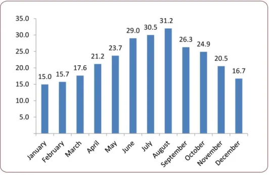
2.1 Geographic Location ... 48 2.2 Geomorphology ... 50 2.3 Geology ... 50 2.4 Soils ... 53 2.5 Land use ... 54 2.6 Climate ... 55
CHAPTER3Analysis of the potential effect of Forest fire on Mass Movement in the study area ... 59
3.1 Introduction ... 59
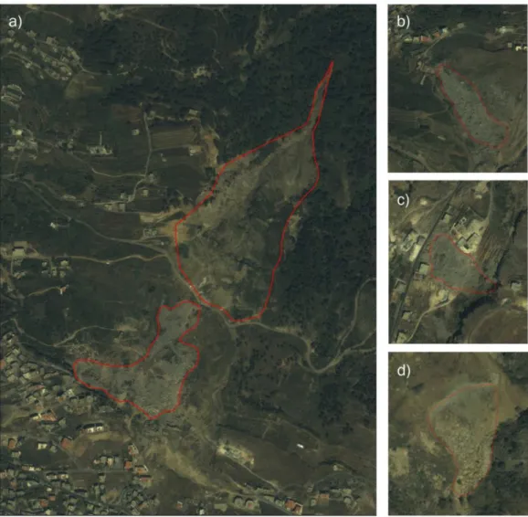
3.2 Mass Movement Inventory Map Production ... 60
3.2.1 Visual Interpretation of Mass Movement and Forest Fire Mapping ... 60
3.3 Burn Severity Estimation Using Remotely Sensed Data ... 65
3.3.1 Gap-Filling LANDSAT 7 SLC-off Single Scenes ... 67
3.3.2 Radiometric Calibration of LANDSAT images ... 68
3.3.3 Change detection of Normalized Burn Ratio Maps ... 71
3.3.4 Cumulative NBR map ... 72
3.4 Mass Movement Field Investigation ... 72
3.5 Forest Fire Burn Severity Field Investigation ... 74
3.5.1 The Mini-Disk Infiltrometer (MDI) ... 74
12
3.7 Statistical Correlation Using Information Value Method (InfoVal) ... 79
3.8 Mass Movement Susceptibility Assessment and Validation of Result ... 81
3.8.1 Establishing relationship between impacting factors and Mass Movement ... 81
3.8.1.1 Rock Type ... 81
3.8.1.2 Soil ... 81
3.8.1.3 Land use ... 82
3.8.1.4 Slope Aspect ... 82
3.8.1.5 Slope Degree ... 82
3.8.1.6 Mean Annual Precipitation (MAP) ... 83
3.8.1.7 Normalized Burn Ratio ... 83
3.9 Soil Water Repellency Status by Means of Infiltration Rate ... 84
3.10 Mass Movement Susceptibility Map and Model Validation ... 85
3.11 Major constraints in Evaluation Mass Movement Susceptibility Maps ... 91
CHAPTER 4Comparative correlation of Forest Fire burn severity with climatic fluctuations and land use change ... 93
4.1 Introduction ... 93
4.2 Climatic variability Detection Utilizing Evpotranspiration and Drought Indices ... 96
4.2.1 Potential Evapotranspiration ... 96
4.2.2 Drought Indices ... 97
4.3 Evaluating Land Use Change Using Normalized Difference Vegetation Index ... 99
4.3.1 Drought as a major Forest Fire driver ... 100
4.3.2 Monitoring land use variation using NDVI ... 103
4.3.3 Analysis results of forest fire burn severity variation through Normalized burn ratio ... 106
4.4 Correlation between Forest fire burn severity and impacting factors ... 108
Conclusion ... 112
References ... 116
13 List of Tables
Chapter 1: A review of Mass Movement Classification, Detection and Susceptibility Analysis
Table 1.1 Classification of most common mass movements in the Mediterranean
Table 1.2 Type and quantity of MM occurring in selected regions of the Mediterranean area
over the last two decades
Table 1.3 Overview of techniques for the collection of MM information H= Highly
Relevance; M=Medium Relevance; L= Low Relevance)
Chapter 3: Analysis of the potential effect of Forest fire on Mass Movement in the study area
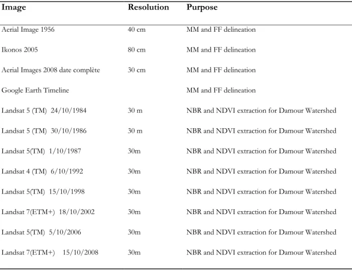
Table 3.1 Number and percentage of Mass Movement delineated between 1956 and 2012 Table 3.2 Aerial and satellite images that were used in the process of mass movement (MM)
and forest fire (FF) detection and delineation for GIS database compilation.
Table 3.3 Mini-Disk infiltrometer (MDI) test values interpretation as suggested by the field
guide for mapping post-fire soil burn severity which was developed by Parsons et al 2010 for the United States Department of Agriculture (USDA)-Forest Service reference
Table 3.4 Environmental attributes used for the preparation of mass movement susceptibility
zonation
Table 3.5 Weight of each parameter defining its contribution to mass movement occurrence
in our study areas as well as the percentage of impact of each parameter on the Mass Movement Susceptibility Map (MMSM) Damour (D)
Table 3.6 Highlighting the impact of Normalized burn ratio (NBR) on the mass movement
susceptibity map through demonstrating the shift in area distribution of the susceptibility classes when NBR was induced and deduced from the (MMSM) equation
Chapter 4: Comparative correlation of Forest Fire burn severity with climatic fluctuations and land use change
Table 4.1 Standardized Reconnaissance Drought Index (RDIst) values which are similar to
SPI Values
14 List of Figures
Chapter 1: A review of Mass Movement Classification, Detection and Susceptibility Analysis
Figure 1.1 Movement and material type as classified by Cruden & Varnes (1996)
Chapter 2: Detailed Description of Study Area
Figure 2.1 Study Area and its geomorphologic unit Figure 2.2 Simplified Geologic Map of the study area Figure 2.3 Soil Map of the study area
Figure 2.4 Land use map of the study area based on CORINE classification of Level 1
description
Figure 2.5 Rainfall map of the study area
Figure 2.6 Average Monthly Temperature of Damour Watershed for the years 1984-2012 Figure 2.7 Average Monthly Precipitation of Damour Watershed for the years 1984-2012
Chapter 3: Analysis of the potential effect of Forest fire on Mass Movement in the study area
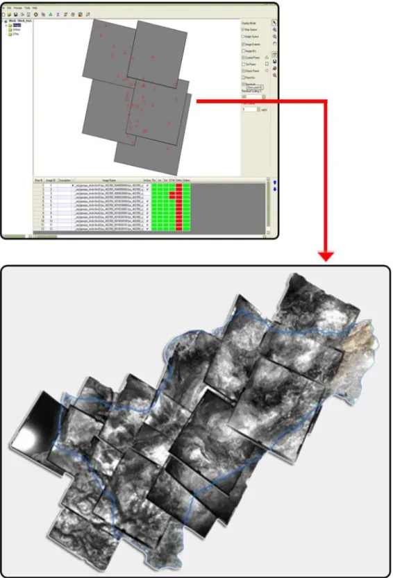
Figure 3.1 Orthorectification of Aerial Photos using ERDAS LPS Figure 3.2 Mass Movement delineation using IKONOS satellite images
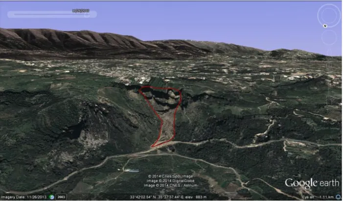
Figure 3.3 Google Earth 3D terrain for enhanced visual interpretation of Mass Movement Figure 3.4 Damour Watershed pre gap filling (a) and post gap filling (b) LANDSAT image Figure 3.5 Comparison of pixel mean distribution and standard deviation of pre and post gap
filling
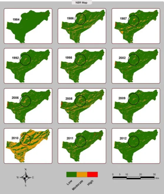
Figure 3.6 Normalized burn ratio (NBR) variation maps in Damour watershed showing the
progression of burn severity from 1986-2012
Figure 3.7 Mass Movement inventory field investigation
Figure 3.8 Mass Movement delineation using Google Earth (on the right) vs. field
investigation (on the left)
Figure 3.9 Forest fire field investigation using the Mini Disk Infiltrometer (MDI)
Figure 3.10 Relationship of mass movement (MM) frequency with Rock Type, Slope Degree,
Mean Annual Rainfall, Normalized Burn ratio, Land Cover, Soil Type and Slope Aspect in Damour
Figure 3.11 Mini disk infiltrometer (MDI) measurement points distribution over the
cumulative Normalized burn ratio (NBR) map. Water repellency (WR) interpretation used accoRDIstng to Parsons et al 2010 for the United States Department of Agriculture (USDA)
15
Figure 3.13 Impact of Normalized Burn Ratio (NBR) as an inducing factor on Mass
Movement Susceptibility Map (MMSM) observed through Shifts in Mass Movement (MM) potential occurrence from High and Moderate to Low and No susceptibility in Damour (D) watershed
Figure 3.14 InfoVAL susceptibility model maps validated through an independent mass
movement validation set extracted from MM inventory and NBR weight factor removed from MMSM equation
Chapter 4: Comparative correlation of Forest Fire burn severity with climatic fluctuations and land use change
Figure 4.1 US National Oceanic and Atmospheric Administration (NOAA) study on
Mediterranean changing precipitation trends
Figure 4.2 Fluctuation precipitation trend between 1986 and 2012 in Damour
Figure 4.3 Increasing Potential Evapotranspiration (PET) of Damour watershed from year
1985 to 2012
Figure 4.4 Decreasing Standardized Reconnaissance Drought Index (RDIst) trendline (in red)
implying a tendency towards increased drought severity
Figure 4.5 Normalized Difference Vegetation Index (NDVI) variation maps in Damour
watershed showing the progression of burn severity from 1984-2012
Figure 4.6 Normalized Difference Vegetation Index maximum (NDVImax) and minimum
(NDVImin) values showing an increasing trendline in NDVImax values insinuating a decreased vegetation cover and increased NDVImin
Figure 4.7 Overlay Analysis between Remotely Sensed NDVI and NCSR Land Use Map
2010
Figure 4.8 Normalized Burn Ratio maximum (NBRmax) and minimum (NBRmin) values
showing an increasing trendline in NBRmax values insinuating an increased burn severity
Figure 4.9 Comparing Normalized Burn Ratio (NBR) to Normalized Difference Vegetation
Index (NDVI)
Figure 4.10 Comparing Normalized Burn Ratio (NBR) to Standardized Reconnaissance
16 List of Annexes
Annex 1 Preconditioning and inducing parameters affecting MM Occurrence (3:Restricted to
this technique, 2=Mainly from this technique, 1:Spplementary).
Annex 2 Optical satellite images used in MM detection and delineation. Annex 3 Radar satellite images used in MM detection and delineation. Annex 4 Mass Movement susceptibility assessment methods.
17
GENERAL
INTRODUCTION
Mass movements (MM) such as mass movements, earth flows, block falls and erosion are among the most invasive hazards causing surface instability favorable to land degradation (Poesen and Hooke, 1997; Atkinson and Massari, 1998; Duman et al., 2005; Bou Kheir et al., 2008; Goswami et al., 2011). They are severe natural hazards because of the extent of their damages and difficulty to control.
According to the database of the Research Center on the Epidemiology of Disasters, MM and related processes killed approximately 61000 people in the world over the period 1900–2009 (EM-DAT, 2010). This trend is expected to continue in the next decades due to increased urbanization and development, continued deforestation and increased regional precipitation in MM-prone areas due to changing climatic patterns (Yilmaz, 2010).
The occurrence of mass movement is influenced by many preconditioning factors conveyed through terrain parameters, including geology, slope gradient, soil, mean annual rainfall, and land use (Zinck et al., 2001; Abdallah et al., 2005; Kamp et al. 2008 ; Hadji et al., 2013). Mass movement is generally triggered by events or factors, such as abundant rainfall, earthquakes, and land use changes (Rodriguez et al., 1999; Huang et al., 2012; Mugagga et al., 2012). Fire is unquestionably a key factor in shaping the current forest landscape of the Mediterranean Basin (Trabaud, 1987; Pausas et al., 2008). It is considered a significant, if not the primary, foundation of geomorphologic and hydrological modification in fire-prone areas over both short and long time scales.
The consequence of fire on Mediterranean ecosystems varies and depends on the intensity, recurrence and location of the event (Tsitsoni, 1997; Broncano and Retana, 2004; Paula and Ojeda, 2006). In the last decades, fire system in the Mediterranean has altered, becoming larger and more intense (Lloret et al., 2009; Moreira et al., 2011). Lebanon being a small country of almost 10452 km2, forest fires are generally small in their area if compared to other countries.
Burned areas can stretch over accumulative area of 40km2/year whereas in other Mediterranean
countries such as Spain, Italy and Greece, total burned forest and wooded area can reach 2080km2, 1180km2 and 390km2 respectively (Alexandrian et al., 1999). Nevertheless, Forest areas
have decreased from 35% of the country’s land area in 1960 to 13% in 2010. A total of 70,600 forest fire events took place between 1994 and 2004. The impact of climatic variations on forest fire is obtaining an increased attention. It is widely recognized that weather plays a key role in shaping extreme fire potential (Fried et al., 2004; Westerling and Bryant, 2008; Wastl et al., 2012).
18 Even though forest fire severity and fire-surface extent are arguabely climatically driven (Pausas 2004; Keeley et al., 2008), many lines of evidence show that fire regime changes are not directly linked to climatic change where on a longer time outlook, fire hazard has generally increased due to increases in population size, grazing practices, and increases in human ignition (Moreira et al., 2010; Salis et al., 2014).
All these issues are addressed in this research from various aspects with the aim of demonstrating the potential impact of forest fire burn severity on mass movement occurrence in Lebanon. Damour watershed represents a good case study since:
1. Its area extends from zero to almost 2000 m in elevation; having a combination of steep slopes, erodible solids in addition to rapid land use change and human interference.
2. It offers an abaundant and complex set of MM.
3. It is categorized as a catastrophic forest fire are by the Ministry of Environment where fire events extend over areas of more than 400 ha.
4. The impact of forest fire on MM occurrence has not been studied yet in Lebanon 5. The production of a MM susceptibility map with the introduction of forest fire as an
inducing factor are nonexistent in order to develop appropriate management plans. 6. Forest fire inducing factors have only been assumed whereas this research provides
an initiative towards semi-quantitative assessment to whether fires are climate or anthropogenic driven.
In this context, there exists a need for mapping MM and forest fire burn severity and track their evolution. Furthermore, assessing the impact of forest fire on MM occurrence through a MM susceptibility map will definitely be a step forward in sustainable management of natural and human resources. For this reason, the work was conducted with the extensive use of GIS and remote sensing in addition to field investigation for the validation of MM and forest fire maps.
This thesis is organized in five chapters as detailed below:
The First Chapter gives an overview of existing studies on Mass movement. It
explains the adopted classifications of diverse types of MM such as slides, falls and flows. It points out various MM detection methods through either geotechnical devices or remote sensing. Moreover, hazard analysis techniques were explained discussed and compared in addition to determining preconditioning and influencing factors especially forest fire.
19
The second studies in depth the study area of Damour watershed. Geomorphology,
geology, soil and land use characteristics were explained as well as natural hazards that are already occurring in the study area. The study area, extending from the Mediterranean coast to around 2000m of elevation covering almost 3.7% of the total area of Lebanon.
The third chapter tests the influence of diverse terrain parameters either preconditioning (Soil, rock type, land use, slope degree and slope aspect) or influencing factors (Forest Fire). The considered parameters were extracted either
from GIS or remote sensing. Forest Fire was thoroughly investigated through
extensive field work and a bivariate GIS based statistical methodology for mass
movement susceptibility zonation InfoVal was used to assess the individual weight factor of every parameter on mass movement occurrence. Mass movement susceptibility map (MMSM) was produced and a validation set was overlain. An accuracy of 70% was established. In order to further highlight the impact of forest fire on mass
movement occurrence, NBR was removed from the MMSM equation. It resulted in
a shift in the distribution of mass movements making the MMSM’s usability for hazard and risk mapping compromised.
The fourth chapter explores the possibility that forest fire in our study area is influenced by climatic variations represented through RDISTst as a drought index or land use changes represented by NDVI as a vegetation detection remote sensing index. A forest fire burn severity (NBR) map was established. It was individually
compared to NDVI maps of the same years as well as RDISTst values of the same years as well. It shows that forest fire burn severity is a consequence of interaction between the two variables and not a result of a sole factor.
The fifth chapter presents a summarizing conclusion of the results obtained
throughout the thesis and setbacks of the work in addition to recommendations concerning forest fire and mass movement adaptive management.
20
CHAPTER
1
A review of Mass
Movement Classification, Detection and
Susceptibility Analysis
This chapter reviews the development and advancement of MM studies emphasizing on general discriminating and modeling techniques. It provides a holistic understanding of the nature of different types of MMs, parameters affecting their occurrence and put forward the wide range of MM detection, modeling and zoning techniques. The chapter concludes that despite of the operational and theoretical limitations due to the extent of data uncertainty as a result of wide range of qualitative and statistically based modeling applications and techniques; MM hazard evaluation still constitutes a suitable, cost-effective process that would eventually serve as prediction and warning systems for communities at risk.
1.1 Introduction to Mass Movement
MM can occur as sudden, short-lived events, as a slow moving slide mass, or as unnoticeably slow moving soil creep. They pose serious direct and/or indirect hazards on short or long term.MM occur in areas where other natural disasters take place such as earthquakes where the impact of the volume of mass wasting exceeds that of the earthquake magnitude. For example, the 2008 Wenchuan earthquake in China resulted in 88000 casualties where one third were killed due to MM, debris flows and rock avalanches triggered by this earthquake (Gorum et al., 2011).
The secondary effects of MM can also be very destructive. In fact, once MM occur in narrow valley floors, they create temporary dams that quickly impound water, resulting later in catastrophic flooding. The most important indirect long-term effect of MM in mountainous terrain is represented through landscape evolution. MM inflicts economic losses and causes numerous fatalities and injuries. For instance, the mean annual cost of MM in Turkey was calculated to be around 80 million USD in 2007 (Yalcin, 2008). For Italy, Austria, Switzerland and France, the damage cost is estimated between 1 and 5 billion USD for each of these countries (Kjekstad and Highland, 2009) On the other hand, an estimated 2.6 billion USD is registered by China as direct and indirect economic loss from MM (Bai et al., 2011). In Lebanon, MM results in deaths and causes damage to construction and the environment estimated at 10-15 million USD annually (Abdallah, 2012). This chapter reviews the development and advancement
21 of MM studies emphasizing on general discriminating & modeling techniques. It provides a holistic understanding of the nature of different types of MMs, parameters affecting their occurrence and put forward the wide range of MM detection, modeling and zoning techniques. The chapter concludes that despite of the operational and theoretical limitations due to the extent of data uncertainty as a result of wide range of qualitative and statistically based modeling applications and techniques; MM hazard evaluation still constitutes a suitable, cost-effective process that would eventually serve as prediction and warning systems for communities at risk.
1.2 Mass Movement Classification
MM represents the lateral and downslope movement of earth materials such as rock, soil, and/or artificial fill (Varnes, 1984). The terms “mass movement”, “slope movement”, and “slope failure” when used in a generic sense, are generally equivalent in meaning. Several classifications of mass movements exist universally (Coates, 1977; Varnes, 1984; Kehew, 1995; Cruden and Varnes, 1996). These classifications are valuable in indicating the range of mechanisms and forms of motion. But it must be appreciated that mass movements in reality involve a combination of processes. Four principal types of movement are identified and described – creep, slide, fall and flow, that are widely recognized in the Mediterranean environments (Nemeok et al., 1972). Each of these can be subdivided into more specific forms of movements. The classification is based on several criteria: 1) type of failure, 2) type of material being displaced, 3) moisture content, 4) type of strain and nature of movement and 5) rate of movement (Table 1.1). The below table shows a schematic MM classification adopting the classification of Varnes (1984), Cruden and Varnes (1996) and Hungr et al. (2001).
22 Table1.1 Classification of most common mass movements in the Mediterranean
Type of movement Materials in motion
Moisture content
Nature of movement Rate of movement
Slide
Translational
Rock slide Unfractured rock mass
Low
Shallow slide approximately parallel to ground surface of coherent rock mass along
single fracture
Very slow to extremely
rapid
Rock block
slide Fractured rock
Shallow slide approximately parallel to ground surface of
fractured rock
Moderate
Debris/earth
slide Rock debris or soil
Low to moderate
Shallow slide of deformed masses of soil
Very slow to rapid Debris/earth
block slide
Shallow slide of largely undeformed masses of soil
Slow
Rotational Rock slump Rock Low Rotational movement along concave failure plane
Extremely slow to moderate Debris/earth slump Rock debris or soil Moderate Slow Fal l
Rock fall Detached rock
joint blocks Low
Fall of individual blocks from vertical faces
Extremely rapid Debris/earth fall Detached cohesive units of soil
Toppling of cohesive units of soil from near-vertical faces
such as river banks
Very rapid Fl ow Rock flow Rock (especially readily deformable types such as shales and
clays)
Low Slow plastic deformation of rock, or soil
Very slow to extremely slow
Debris flow
Mixture of fine and coarse debris
(20-80% of particles coarser
than sand-size)
High Flow usually focused into pre-existing drainage lines
Very rapid
Earth flow
Slow > 80% sand-size Low Confined elongated flow Slow
Rapid Soil containing sensitive clays
Very high
Rapid collapse and lateral spreading of soil following
disturbance, often by an initial slide
23 Due to the complexity of the Mediterranean terrains, the different levels of awareness of the impact of MM on the territory and somehow limited resources available for inventory and maintenance, detailed MM records occurring in the Mediterranean region still required (Guzzetti, 2000; vanWesten, 2006; Triglia et al., 2010; Guzzetti et al., 2012). Nevertheless, in some specific locations, the information is available on historical and recent MM with consequences collected from available bibliography and archives. As an example, a large database has been constructed in Italy showing 31,000 MM events at 21,400 sites (equivalent to a density of 1 MM per 15 km2)
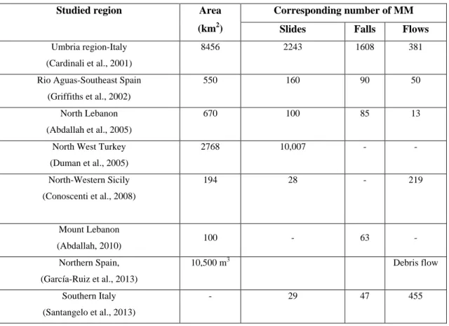
(Guzzetti, 2000). This information was obtained from about 100,000 newspaper articles and 2,000 scientific and technical reports. In addition, the exact distribution of each type of MM (slide, fall and flow) is often restricted to particular studied zones in a given country (Table 1.2). The MM density varies between 0.29 and 0.54 per km2 according to the studied region. It is
highest in the case of slides reaching 0.29 per km2 in Southeast Spain.
Table 1.2 Type and quantity of MM occurring in selected regions of the Mediterranean area over the last two decades
Studied region Area
(km2)
Corresponding number of MM
Slides Falls Flows
Umbria region-Italy (Cardinali et al., 2001)
8456 2243 1608 381
Rio Aguas-Southeast Spain (Griffiths et al., 2002)
550 160 90 50
North Lebanon (Abdallah et al., 2005)
670 100 85 13
North West Turkey (Duman et al., 2005) 2768 10,007 - - North-Western Sicily (Conoscenti et al., 2008) 194 28 - 219 Mount Lebanon (Abdallah, 2010) 100 - 63 - Northern Spain, (García-Ruiz et al., 2013) 10,500 m3 Debris flow Southern Italy (Santangelo et al., 2013) - 29 47 455
24
1.2.1 Falls
Falls occur when masses of rock or other material detach from a steep slope or cliff and descend by free fall, rolling or bouncing. In the Mediterranean environments, falls are less frequent than slides and are restricted mostly to cliff-rock outcrops with vertical to very steeply dipping and dense joints (Figure 1.1a to 1.1c). Velocities are very high and they generally occur quite suddenly. Large rock falls originating from a considerable height above the ground spread their debris over an extensive area unless the dispersal of material is confined by topography (Carere et al., 2001; Fard, 2001). The highest rock fall hazard exists when joints and bedding planes are inclined at a steep angle, as in the highly folded stratigraphy common in major mountain chains like the Alps. Since a rock rarely loses equilibrium without a inducing mechanism, earthquakes and freeze-thaw are the major factors interfering with rock stability (Watts, 2001). Debris falls are similar except they include a mixture of soil, vegetation and rocks.
1.2.2 Slides
Slides are mainly defined as slope movements of coherent masses along one or more well-defined shear surfaces (Nemeok et al., 1972).The great majority of slides in the Mediterranean environments are small and shallow with lengths of a few tens of meters and depths of 2-3 m. Slides in bedrock are less common, but may attain enormous dimensions and involve the movement of millions of cubic meters of material. Some slides took place during ancient times and are still continuing their activity until today. An example is the Fadalto MM located in Italy, which goes back to the late glacial time, and includes a large scarp with debris accumulation that occupies a belt of about 280 m (Eisbacher and Clague, 1984; Pelligrini and Surian, 1996).
Slides can be subdivided into transitional slides, which have predominantly planar shear surfaces, and rotational slides in which the shear plane is concave-up (Table 1.1, Figure 1.1d to 1.1i).
Translational failure is common in cliff forming units, particularly where there is interbedded competent and incompetent rock. It is increased by the presence of marls, and invariably marly or argillaceous limestone. Rotational failure commonly occurs in relatively unconsolidated poorly cemented sandstones, weathered basalts and the surficial cover. The rotational movement can result in the upper part of the slumped mass being back-tilted towards the failure surface. Moreover, the movement may start as translational along a joint parallel to the cliff face and either continues deeper, thus becoming prone to rotational mode, or may induce rock/debris fall. This type of slope failure creates a great deal of property damage. A good example is the MM disaster which affected the city of Ancona, central Italy, in 1982 (Alexander, 1991).
25
1.2.3 Flows
Debris flows (viscous flows) tend to be less deep-seated and rather less common slope failures than MM (Figure 1.1j to 1.1l). The high water content means that the material moves faster and farther from the original source. Mud Flows on the other hand, are highly fluid, high velocity mixture of sediment and water that has a consistency ranging between soup-like and wet concrete. They could travel at a speed rate that reach 1 km/hr making them extremely dangerous. These usually result from heavy rains in areas where there is an abundance of unconsolidated sediment (Watts, 2001). A good example is the huge earth flow in Aquoura area (Lebanon), where the constructed artificial lakes act as an inducing parameter in activating this flow
(Figure1.1j).
Moreover, biotic destructionby MMs is also common; widespread stripping of forestcover by mass movements (Schuster and Highland, 2007). In order to be able to create safety measures and lay hazard management foundations, we need to understand the processes that initiate land sliding and then prepare for consequent susceptibility mapping (Yalcin, 2008).
26 1.3 Factors Influencing the Occurrence of Mass Movement
MM do not occur randomly (Turcotte et al., 2002). Slope failures are the outcome of the interaction of physical procedures and mechanical laws controlling the stability or failure of a slope. The study of MM involves an understanding of these factors that affect their occurrence. These factors can be categorized into; (a) preconditioning (topography, geology, hydrogeology, soil, and land use) and (b) inducing factors (neotectonics, rainfall, flooding, forest fire, manmade excavation and climatic variation) (Cendrero and Dramis, 1996; Dahal et al., 2008).
1.3.1 Preconditioning Factors
Preconditioning factors are the inherent land surface characteristics and morphology and consequently determine the innate liability of a slope to failure or mass wasting. The intrinsic variables determine the pre-dispositioning of a site to MM and include bedrock geology, hydrology, soil, topography (slope aspect, slope gradient) and land use pattern. (Cendredo and Dremis, 1996 ; Sanchez et al., 1999; Dahal et al., 2009).
1.3.1.1 Topography
Topography and relief are synonymous terms used to denote the configuration of the land surface (Carte and Ciolkosz,1991). Being the element that portrays the elevation and shape of the land, topography is a decisive surface characteristic in slope failure modeling (Crozier, 1986; Datta et al., 2010). Slope characteristics used to describe relief include the aspect, gradient, length, and curvature of the slope. Gentle slopes are expected to have a low frequency of MMs because of lower shear stresses exerted on surficial materials associated with low gradients. At local scales, slope gradient affects the concentration of moisture and the level of pore pressure, and is often useful to resolve detailed patterns of instability, while at larger scales; it controls the hydraulic continuity (Abdallah, 2007). Slope orientation can influence mass wasting initiation, the distribution and density of MM by controlling the concentration of soil moisture (Wieczorek et al., 1997). Moisture retention and vegetation is reflected by slope aspect, which in turn may affect soil strength and vulnerability to slope failure (Florinsky, 2012). Moreover, if rainfall has a manifested directional constituent by influence of a existing wind, the amount of rainfall falling on a slope may vary depending on its aspect (Dai et al., 2002). Slope curvature affects flow divergence and convergence (Lewis et al., 1994) hence affects the amount of sediment loss. For instance, concave greatly reduced the total sediment loss in comparison with a uniform or convex slope.
27
1.3.1.2 Lithology
Lithology is one of the most important parameters in MM studies because different lithological units have different liability degrees (Yesilnacar and Topal, 2005, Yalcin and Bulut, 2007; Garcia-Rodriguez et al., 2008; Nefeslioglu et al., 2008). The physical properties of slope-forming materials such as fractures, fissures and rock strength that are involved in the mass wasting are related to the geology (Dai and Lee, 2002). The rock type, structure and texture influence MM processes. MMs are quite important where clayey rocks (clay-stones, marls, shales, muds, flysch) or morainic materials outcrop. The presence of these rock types in the Mediterranean region favors various types of mass movements, including landsliding. The clayey, shaly, or marly horizons are potential shear planes as they retain water. Once saturated, they behave like a liquid resulting in occurrence of rapidly moving mudflows. The soluble carbonate rocks also pose problems; they may include expanding clays which interact with and weaken the carbonate cement, hence weakening the rock itself (Chebbani et al., 1999, Abdallah, 2007).On the other hand, highly fractured rocks may possess both significant permeability and fracture porosity. Due to the fact that joints comprise of the weakest zones of rock masses, the anisotropy created by the joints is of significance. More specifically, in jointed rock slopes, the joints produce the natural mechanisms of planar, wedge and toppling failure (Pal et al., 2011).
1.3.1.3 Soil
The structural stability of soils is a physical characteristic that influences their behavior during processes of degradation. Soil degradation mainly involves destruction of soil structure (Baumgartl and Horn, 1991). Soil properties which influence rainfall acceptance include particle size distribution, structural stability, organic matter content, soil chemistry and clay mineralogy and water transmission characteristics (Lal, 2001).Generally, soils with faster infiltration rates, higher levels of organic matter and improved soil structure have a greater resistance to erosion.
Moreover, when soil management gives way to the accumulation of plant residues, they tend to increase the aggregate stability of the soil unlike other tillage and cropping practices which lower soil organic matter levels, cause poor soil structure, and result to an increase in soil erodibility (Rachmanet al., 2003). Crust formation in the unstable soils of arid regions usually results from the combined effect of raindrop impact energy and the dispersion of clay particles. These factors reduce the hydraulic conductivity of the soil surface and hence infiltration rate into the soil (Carmi and Berliner, 2008). A subsequent augmentation in the amount of runoff water can contribute to greater rill erosion troubles. The soils found in the Mediterranean climate are highly variable, but do have in common properties that make them susceptible to water erosion. These
28 characteristics lead to surface sealing during rainfall. However, in some cases, this coating might shape to decrease the amount of soil loss from sheet or rain splash erosion in the absence of any protective vegetation.
1.3.1.4 Land use
Among the factors inducing the potential intensity of mass wasting, land use is considered one of a high important factors (Ruff and Czurda, 2008; Chen and Huang, 2013). Deforestation, overgrazing and intensive agriculture as a result of anthropogenic pressure are often one of the main preconditioning factors of MM (Karsli et al., 2009). Land use change cause large alterations in the hydrological and morphological function of slopes, affecting infiltration characteristics, and runoff production, and even the shear strength of the soil. Vegetation (especially woody type) limits the movement of the debris present along slopes in two folds, i.e. hydrological (capacity of infiltration into the soils, soil moisture, groundwater level, etc.), and mechanical (root length). Where the vegetation cover is sparse, the slow movement inside the debris will not be ceased. Hence, dry environments under natural conditions are biologically marginal, and they can be expected to be highly susceptible to mass movement (Thornes, 1995; Garcia-Ruiz et al., 2010). A common method for decreasing water runoff and soil erosion is via stable and suitable vegetative cover (Dunjo et al., 2003; Chaplot and Bissonnais, 2003).
1.3.2 Inducing Factors
MMs can be prompted by a multiplicity of external Inducing or dynamic factors, such as intense rainfall, earthquake shaking, forest fires, flooding in addition to the expanded development in unstable hillslope areas under the pressures of escalating population and urbanization (Dai and Lee, 2002).
1.3.2.1 Neotectonics
MMs occur frequently in areas where minor and major morphotectonic events (uplift, subsidence, faulting, jointing and earthquakes) occur (recent or past), the latter being important throughout the Mediterranean basin (Pelligrini and Surian, 1996; Del Gaudio and Wasowski, 2004; Bottari and Sepe, 2013). Earthquakes have a decisive and clear power on slope stability; natural and man-made slopes which become equally unstable during an earthquake (Keefer, 1994). The instability of slopes due to an earthquake causes more destruction than the actual earthquake itself (Sato et al., 2007; Kamp et al., 2008; Owen et al., 2008). Ground shaking and
29 acceleration due to seismic waves energizes the weakened forces on the soil and rock masses even though ground displacements due to seismic waves may be sufficiently large to rupture bonds between soil particles. An earthquake does not only add adverse forces to a slope but may also enduringly diminish the shear strength in a slope (Hack et al., 2007). Earth section (mostly composed of soil and alluvium) became vulnerable to future failure through loss of cohesion and numerous cracks that were induced by the strong ground motion. According to Dunning et al. (2007) “the seismic shaking leaves an imprint (fractures, tension cracks and brittle deformation of rocks) on the slope stability of the area that may have long lasting effects on the future rates and spatial distribution of MMs”. The widespread fracturing implicates that, in the future, slope failures can be effortlessly initiated by severe rainfall or low intensity earthquakes (Saba et al., 2010). Examples showing the strong relations between seismic events and mass movements were described in the historic literature. The major earthquake that hit Lebanon in 551 A.D. depicts the huge slides occurring at Chekka, and in fact was responsible for constructing its current coastal configuration (Khawlie, 1992). In 1927, a destructive earthquake affected the west bank of Jordan River inducing major MMs stopping the river flow for 21 days (Ambraseys and Barazangi, 1989). The 2002 Avaj, Iran earthquake of magnitude 6.5 triggered many MMs over an area of about 3600 km2 (Mahdavifar et al., 2006).
1.3.2.2 Intensity Rainfall
The Mediterranean environment is characterized by seasonally contrasted climate, with low annual rainfall and irregular but frequent rain events with extreme intensities, scarce vegetation cover and poor soil characteristics (López-Vicente et al., 2008). The vulnerability of the Mediterranean region to MM hazard is mostly influenced by the frequent coincidence of dry summer periods with violent rainstorms (Petan et al., 2010). Precipitation acquires an erosive characteristic represented by an aggressive mechanism that targets soil deterioration and reduction of shear strength between its particles. (Martınez-Casasnovas et al., 2002) It is generally recognized that rainfall-induced MM are caused by increased pore pressures and seepage forces during periods of intense rainfall (Anderson and Sitar, 1995) which decreases the effective stress in the soil and thus reduces the soil shear strength, eventually resulting in slope failure (Brenner et al. 1985). The impact of raindrops on the soil surface can break down soil aggregates and disperse the aggregate material. Lighter aggregate materials such as very fine sand, silt, clay and organic matter can be easily removed by the raindrop splash and runoff water; greater raindrop energy or runoff amounts might be required to move the larger sand and gravel particles. The shallow failures of slopes in these soils are usually caused by infiltration due to prolonged rainfall (Kim et al., 2004). Furthermore, raindrop energy causes a splash coating that alters the infiltration process
30 and increases runoff, inhibiting a proportion of rain from percolating into the soil. But not every rainfall incident leads to runoff and erosion. The notion of a threshold value and duration below which erosion does not occur, a threshold of minimum intensity, is acquired through the combination of an erosivity index, a threshold of duration of high intensity and a duration of the rainfall which produces soil saturation and the degeneration of the soil constitution. Soil movement by rainfall (due to raindrop splash) is usually at peak and most perceptible during short-duration, high-intensity thunderstorms (Assouline and Ben-Hur, 2006). Rainfall intensity records are difficult to ascertain and even if we had a recorder, it would have short term data that could be insufficient to establish a trend or a threshold for a large study area, but it has been found by Roose (1979) that starting from long series of daily rainfall observation, it is possible to find satisfactory monthly and yearly averages of rainfall erosivity index.
1.3.2.3 Forest fires
Forest fires are a usual element in the Mediterranean basin. Forest fires have become more frequent and more severe in the last years. From 1996 to 2005, the annual average number of fires in Southern Europe exceeded 61,000, which is 34% more than recorded during 1986–1995 (Vilen and Fernandes, 2011). Furthermore and according to the European Commission, 0.5 million hectares are burned every year in Portugal, Spain, Greece, Italy and France (EC, 2010). As a result of more frequent and more severe fires, Mediterranean ecosystems can experience loss of biodiversity, MM and desertification. This increase in wildfire occurrence is associated with anthropogenic climate change. Partial or complete combustion of vegetation and litter by fire has important implications for post-fire hydrological response (Shakesby, 2011).
Depending on its severity, wildfire temporarily reduces or stops transpiration, interception and surface storage capacity for rain (Loaiciga et al., 2001). Perhaps the most discussed effect of forest fire is enhanced water repellency, termed the hydrophobic characteristic of soil particles (DeBano, 2000; Arcenegui et al., 2008; Rodríguez-Alleres et al., 2012; Beatty and Smith 2013). Water repellency diminishes the attraction of soils to water, causing the soil to oppose wetting for periods ranging from a few seconds to hours, days, weeks, or months (Doerr et al., 2000). Enhanced water repellency has considerable geomorphologic and hydrological consequences, including reduced soil infiltration ability, increased overland flow, and enhanced soil erosion. In general, water repellency in fire-affected Mediterranean type climatic regions, such as our study area, has been reported in pine forests (Arcenegui et al., 2008). On the other hand, the most commonly reported weathering effect of fire is spalling (Zimmerman et al., 1994), in which flakes of a substance are broken off a larger solid body, leading to surface failure. Vertical fracturing affecting an entire rock boulder has been reported, as have irregular linear and curvilinear
31 fractures (Ballais and Bosc, 1994). Fire-blackened boulder surfaces are strong evidence that rock failure occurs at a delayed stage of the fire, likely throughout cooling or days or months after a fire. In mountainous locations that are likely to be affected by freeze-thaw weathering, it is expected that weathering due to fire could be 10-100 times more effective than frost action (Shakesby and Doerr 2006, Stine, 2013).
1.3.2.4 Manmade excavation, road construction, unplanned urbanism
Unplanned housing development built on steep slopes frequently lacks any form of adequate slope drainage and hence makes steeper slopes particularly vulnerable to MMs (Anderson et al., 2007). On the other hand, urban expansion reclassified many quarries into residential areas hence increasing the risk of any potential rock failure (Kuzu and Ergin, 2005). Moreover, road construction removes the forest vegetation, disturbs forest floor, and damages soil structure, which dramatically increases the cut and fill slopes soil loss (Parsakhoo et al., 2009). Moreover, during a blasting excavation, the induced vibration propagates in a rock mass and result in damage to the surrounding rock inducing weakness and vulnerability to failure (Haibo et al., 2011). Road cuts can also intercept subsurface water by severing natural pipeflow, or by creating artificial areas of water resurgence by disrupting flow nets (Eisenbies et al., 2007).
1.3.2.5 Climatic Variations
The Mediterranean climate is characterized by episodic winter rainfall, and dry summers, with a distinctive regime of soil or rock moisture. Intense rains exhibit an erratic temporal and spatial distribution, and can be much localized, particularly in the driest parts of the Mediterranean (Alonso-Sarria and Lopez-Bermudez, 1994; Wainwright, 1996). In mountainous areas, where temperatures are usually below zero in winter, Freeze-thaw and thermal stress lead to an induced weathering and susceptibility to fracturing of rocks. The frequent fluctuation in temperature in the winter season which causes freezing and melting processes of water particles in short periods of time greatly enhances the destabilization of soil as well as rock formations. AccoRDIstng to Zaruba and Mencl (1984) “water freezing in rock fissures increases in volume and thus tends to widen them; rocks penetrated by fissures thus show decreased cohesion”. Rock fall is particularly triggered by the thermal expansion of ice in cracks or the freezing of an exposed face followed by rapid warming creating hydrostatic pressures behind the frozen rock face) (Jakob and Lambert, 2009).
32 Temperature
According to the IPCC 4th assessment report presented in 2007, the Mediterranean region will be witnessing an increase of an average of 1.5 °C to 2 °C by 2050 and it is very likely (>90%) that cold days, cold nights and frosts have become less frequent over most land areas, while hot days and hot nights have become more frequent. Foremost, it is likely (>66%) that heat waves have become more frequent over most land areas (IPCC, 2007). Hotter, drier summers in the semi-arid regions (Plantonet al., 2005) and increase in the duration and severity of low-flow periods and a decrease in groundwater recharge (Booij, 2005) will drastically affect several previously listed factors primarily forest fire occurrences. The Mediterranean Basin fire regime has shifted during the twentieth century, and this shift was associated with the relative importance of the two drivers (human-driven fuel changes and climatic changes). Specifically, current area burnt is mainly driven by climatic conditions related to drought (Pausas and Fernández-Muñoz, 2012). An analysis of trends in forest fire occurrences in the Mediterranean shows the average annual number of forest fires throughout the Mediterranean basin is twice as many as during the 1970s. In the countries where data have been available since 1950s, a large increase in the number of forest fires can be observed from the beginning of the 1970s: Spain (from 1 900 to 8 000), Italy (from 3 400 to 10 500), Greece (from 700 to 1 100), Morocco (from 150 to 200), Turkey (from 600 to 1 400) (FAO, 1998). Furthermore, the notion that rock surface temperature changes may cause rock falls is not altogether new. It has been identified by geomorphologists as being responsible for slope instabilities (Gunzburgera et al., 2005).
Precipitation
Since the capacity of air to hold moisture is a function of temperature (Fowler and Hennessy, 1995), higher surface temperatures will definitely signify greater water-holding capacity of the atmosphere as well as increased evaporation. Both effects together should increase atmospheric moisture. Hence, climate change is expected to lead to a greater frequency and magnitude of heavy precipitation. Some observations and modeled simulations agree with this hypothesis (Groisman et al., 2005; Kharin and Zwiers, 2005). Given this possibility, together with the fact that precipitation is the most common inducing agent for mass movements, exceeding earthquakes and slope undercutting (Crozier, 1986), it is not surprising that increased mass movement activity is commonly listed as an expected impact climate change. Impacts from more intense precipitation events include increased flooding, mass movements, avalanches, and mudslides. With an irregular distribution of the rainfall throughout the year and an increasing trend of extreme events (Ramos and Martínez- Casasnovas, 2006; Alvioli et al., 2014), in which most water runs off due to the high rainfall intensity. The increase of high-intensity annual
33 precipitation extremes, separated by long dry periods, may cause higher runoff rates when intensity is higher than the steady-state infiltration rates. (Nearing, 2001; Pruski and Nearing, 2002; Nearing et al., 2004; Martínez-Casasnovas and Ramos, 2009) This will affect the hydrological environments governing slope instability through, for example, changes in antecedent pore pressures and alteration of trigger event magnitudes. Climate change is expected to affect soil erosion based on a variety of factors, including precipitation amounts and intensities, temperature impacts on soil moisture and plant growth (Zhang et al., 2010). Relationships between rainfall patterns and slope instability are reported in the literature for a range of slope failure mechanisms (e.g. shallow and deep-seated first-time slides and reactivated movements) and climates (Dixon and Brook, 2007). This could increase the frequency of occurrence of high pore pressures, and thus the activity of rainfall-triggered mass movements (Buma and Dehn, 1998). Quantitative predictions of changes in precipitation regimes as related to climate changes are highly uncertain, given the limited capability to simulate the fundamental processes which control the precipitation formation, particularly high for small-scale atmospheric processes (Diodato et al., 2011). Moreover, different types of mass movement will respond either to meteorological changes in the long term (monthly or yearly rainfall) or short term (daily or weekly rainfall) (Asch, 1996). Knowledge is required on how predicted climate change could modify the frequency and magnitude of slope instability events so that impact on the built environment can be assessed and remediation strategies developed. Annex 1 presents a combination of preconditioning and inducing parameters affecting MM Occurrence including techniques used to extract these data layers.
1.4 Land Instability Detection and Zonation Methods and Techniques
Detecting the spatial distribution and amount of deformation is critical for understanding the physical causes and eventually warning of possible occurrence. Several innovative instruments and techniques are now available to monitor the activity of slopes (Bozzano et al., 2011). These instrumentations and techniques can be mainly classified as geotechnical and remote sensing techniques (Table 1.3) . MM inventory maps are prepared for multiple reasons including: (1) detecting the extent of MM in a certain watershed (Duman et al., 2005; Trigila et al., 2010), (2) being an essential step in MM hazards and hazard mapping ( a lteanu et al. 2010), and more importantly (3) to analyze the development of the landscapes that are regularly attained by MM events. MM maps can be prepared using different techniques (Guzzetti et al., 2006) . Selection of a specific technique depends on several criteria: the use of the inventory, the coverage of the region studied, the base maps scale, the characteristics of the available imagery, the experience of the investigators, and the resources available to complete the work (Guzzetti et al., 2000; Van
34 Westen et al., 2008). Hence, MM inventory data are gathered at dissimilar scales, using a diversity of methods. MM inventory includes the location, classification, volume of MM in an area. Inventories need data that is continuous and extends over the entire MM distribution. MM inventory maps are prepared for different objectives such as: localization and classification of MM in an area, determining the frequency-area statistics of slope failures, representing the abundance of MM, and most importantly, supplying relevant information to construct MM hazards or hazards (Galli et al., 2008). Simply, MM inventories can be divided into two main types: archived and geomorphological. Achieved can be retrieved from literature and other archive sources and geomorphological can be classified as event-based, seasonal or multi-temporal (Galli et al., 2008; Guzetti et al., 2012).
1.4.1 Geotechnical Methods
Geomorphologic MM mapping is hindered by the complexity of detecting MM in the field, particularly old ones. The complexity has various causes, including: (1) the size of the MM, often too outsized to be entirely located, (2) the standpoint of the filed examiner is sometimes insufficient to see all parts of MM with the same accuracy, and (3) the fact that old MM are habitually partly or entirely covered by trees, or have been partially distorted by other MM processes and anthropogenic activities such as agricultural and forest practices (Santangelo et al. 2013). The most used geotechnical methods are Total Station Theodolite (TST), Electronic Distance Measurement (EDM), Slope Inclinometer, Wire Extensometer, and Global Positioning Systems. On the case of geotechnical and geodetic methods, all of the proposed techniques are applicable for obtaining general and specific information on the type and (visual) characteristics of MM: (1) to exploit for improved visual interpretation of the aerial photographs or satellite images and (2) to check (validate) inventory maps prepared using other techniques, chiefly the interpretation of aerial photographs (Guzzetti et al., 2000; Cardinali et al., 2001). On the other hand, it is always recommended to accompany results obtained by remote sensing with geotechnical techniques in order to calibrate obtained results and evaluate the performance of new (remote sensing) technology.