Publisher’s version / Version de l'éditeur:
PERD/CHC Report, 1997-11
READ THESE TERMS AND CONDITIONS CAREFULLY BEFORE USING THIS WEBSITE.
https://nrc-publications.canada.ca/eng/copyright
Vous avez des questions? Nous pouvons vous aider. Pour communiquer directement avec un auteur, consultez la
première page de la revue dans laquelle son article a été publié afin de trouver ses coordonnées. Si vous n’arrivez pas à les repérer, communiquez avec nous à [email protected].
Questions? Contact the NRC Publications Archive team at
[email protected]. If you wish to email the authors directly, please see the first page of the publication for their contact information.
Archives des publications du CNRC
For the publisher’s version, please access the DOI link below./ Pour consulter la version de l’éditeur, utilisez le lien DOI ci-dessous.
https://doi.org/10.4224/12328760
Access and use of this website and the material on it are subject to the Terms and Conditions set forth at Ice problems related to Grand Banks petroleum fields
Fuglem, M.; B. Wright and Associates Ltd.; K. R. Croasdale and Associates Ltd.
https://publications-cnrc.canada.ca/fra/droits
L’accès à ce site Web et l’utilisation de son contenu sont assujettis aux conditions présentées dans le site LISEZ CES CONDITIONS ATTENTIVEMENT AVANT D’UTILISER CE SITE WEB.
NRC Publications Record / Notice d'Archives des publications de CNRC: https://nrc-publications.canada.ca/eng/view/object/?id=a3514af1-92b3-475b-9ba7-64bbf767d2d6 https://publications-cnrc.canada.ca/fra/voir/objet/?id=a3514af1-92b3-475b-9ba7-64bbf767d2d6
submitted to
Dr. G.W. Timco
National Research Council
of Canada
on behalf of PERD Sub-Task 5.3 Oil & Gas
PERD/CHC Report 20-6
by
B. Wright & Associates Ltd.
K. R. Croasdale & Associates Ltd.
M. Fuglem - Memorial University
1.0 Introduction 1
2.0 Background 2
2.1 1992 Frontier Planning Study 3
2.2 1994 Frontier Competitiveness Study 4
2.3 Recent Industry Perspectives 9
3.0 Objectives 12
4.0 Approach 12
5.0 Grand Banks Setting 16
5.1 Environment 16 5.2 Exploration 17 5.3 Development 18 6.0 Development Scenarios 21 6.1 Development Opportunities 22 6.1.1 Significant Discoveries 22
6.1.2 Generic Oil Fields 28
6.2 Ice Climate 29 6.2.1 Icebergs 29 6.2.2 Pack Ice 31 6.3 Development Approaches 34 6.3.1 General 34 6.3.2 Development Options 35
6.3.3 Representative Development Systems 40
7.0 Ice Related Problems 43
7.1 Fixed Structure Developments 44
7.1.1 Iceberg Impact Loads 45
7.1.2 Other Ice/Structure Interaction Considerations 49
7.1.3 Tanker Loading in Ice 50
7.2.3 Iceberg Influences on Subsea Facilities 58
7.2.4 Tanker Operations in Ice 59
7.3 Subsea Development Systems 60
7.4 Miscellaneous 60
8.0 Development Costs & Economics 62
8.1 System Components & Assumptions 62
8.2 Capital & Operating Costs 66
8.3 Comparative Economics 72
8.4 Implications 85
9.0 Ice Research Requirements 89
9.1 R&D Needs & Priorities 89
9.2 Recommended R&D Initiatives 94
9.3 Communication & Collaboration 97
10.0 References 98
Appendix 1: Suggested Work Scopes for Recommended
Short Term R&D Initiatives
- An Assessment of Current Iceberg Management Capabilities - Improved Iceberg & Small Ice Mass Information for Probabilistic
Ice Load Calculations
- Moored Vessel Stationkeeping in Moving Pack Ice
1.0
Introduction
Over the past several decades, the petroleum industry has carried out extensive exploration programs on the Grand Banks, which lies off the east coast of Newfoundland. To date, these efforts have resulted in a number of significant discoveries, including the Hibernia and Terra Nova oil fields. At the present time, proven oil and gas reserves in the Grand Banks region are estimated at 1.5 billion barrels of oil and 1 trillion cubic feet of gas, with probable reserve estimates being considerably higher. In recent years, there has been a reduced industry focus on the Grand Banks, which is consistent with the general decline in activity levels across the Canadian frontiers. However, development initiatives that began in the 1980’s have continued, with the Hibernia project now being implemented and development of the Terra Nova field being aggressively pursued. As these Grand Banks development projects proceed and become operational, it is likely that smaller oil reserves such as the Whiterose and Hebron discoveries will be developed and tied into the region’s production infrastructure. With development, it is also clear that further exploration will be stimulated on the Grand Banks, as evidenced by the renewal of exploratory drilling in 1997.
From an environmental perspective, the Grand Banks is generally recognized as one of the most hostile operating environments in the world, since it is influenced by a range of adverse factors. The primary environmental constraints include high waves, icebergs and sea ice, all of which have influenced the exploration approaches used to date and the design philosophies for the development systems being planned. Strong winds, structural icing, and poor visibility are also of concern, but are more important in terms of affecting operations than influencing design. In all cases, floating ice in the form of both icebergs and pack ice, has been viewed as the key environmental constraint for various Grand Banks development scenarios.
NRC, on behalf of PERD, has contracted B. Wright & Associates Ltd. to undertake an R&D planning study regarding ice-related problems on the Grand Banks, primarily as they influence the development of the smaller oil fields that have been discovered in the area. This report provides the results of the study, and has the objective of identifying and priorizing ice-related problems for oil fields like Whiterose, Hebron and Terra Nova, along with associated R&D needs. In keeping with PERD’s new R&D planning philosophy, a scenario based approach has been used to focus on key design and operational issues. The relative importance of the different Grand Banks ice problems that are highlighted in this study have been assessed in terms of their impact on the cost and economics of potential developments, and on current perceptions about the safety and environmental acceptability of these projects.
2.0
Background
The Federal Energy Research and Development Program, which is coordinated by the Panel on Energy R&D (PERD), has been in place since the time of the first OPEC oil embargo in 1973. The program was established as part of the federal government’s response to this oil supply crisis, with a view to conducting energy related R&D that in the longer term, would enhance the security of energy supplies for Canada, particularly oil. PERD funding reached maximum levels of about $170 million per year in the mid 1980's, but with recent federal budget cuts, has been reduced to annual levels of about $60 million. Currently, PERD’s funding remains subject to downward pressures that are associated with government’s fiscal restraint policies. In addition, new federal initiatives to reduce greenhouse gas emissions could lead to pressures for PERD to redistribute funds away from hydrocarbon fuels. The objective of the PERD program is to provide the science and technology that is required to support a diversified, economically and environmentally sustainable energy economy in Canada. In terms of scope, the R&D that has been conducted under the auspices of PERD has addressed a variety of energy issues, ranging from the development of fossil fuels and renewable energy resources, to questions of energy efficiency and the impact of greenhouse gases on climate change. Since the program’s inception, the majority of PERD’s funding has been allocated to support internal R&D within various government departments and agencies.
Historically, PERD has directed a considerable amount of effort towards frontier oil and gas issues, with the objective of supporting research that will enhance Canada’s ability to produce reserves from its harsh frontiers in a safe, economically competitive and environmentally acceptable manner. The frontier R&D initiatives that PERD has pursued encompass a wide range of environmental, geotechnical, marine engineering and transportation topics related to the development of oil and gas reserves in Canada’s Beaufort Sea and MacKenzie Delta, Arctic Islands, and East Coast regions. Most of this R&D has been heavily oriented towards supporting government regulatory needs. This appears to have been an appropriate strategy for PERD’s frontier program when industry activity levels were high, government needed the knowledge to implement regulations, and the expectation for economic frontier developments based on the technology being put in place by industry was high. However, smaller than expected frontier discoveries, high development costs and long development lead times, combined with falling oil prices and the poor economic conditions that have been experienced over the past decade, have led to a significant decline in industry’s interest in the Canadian frontiers. From a PERD perspective, these factors have led to a de-emphasis in the frontier component of its program, with budget allocations for frontier R&D falling from roughly $20 million per year in the mid 1980's, to a present annual level of about $8 million.
These factors have also led PERD to reconsider the focus of its frontier program, away from research studies that support the regulation of assumed frontier developments, towards R&D thrusts that can make a difference in terms of lowering frontier development costs, mitigating technical risks, and creating the possibility of more economically attractive projects.
2.1
1992 Frontier Planning Study
Industry began to pursue this basic theme of focussing frontier R&D towards initiatives that could reduce the costs and risks of potential frontier development projects, through their representation on various PERD Committees in the late 1980s (CPA, 1990). However, the theme was more fully developed in late 1992, in a PERD sponsored Research Planning Study for Canada’s Frontier Oil and Gas, conducted by K. R. Croasdale & Associates. This study focussed on a number of potential frontier development scenarios and was specifically aimed at defining the technology R&D opportunities that could improve the cost competitiveness of Canadian frontier projects. The study showed that some of these development scenarios could be cost competitive, particularly if focussed research could achieve technology uplift and lower costs. The underlying rationale for the study was to show that by improving the economics of potential frontier developments, or by triggering developments that appear uneconomic, Canada would benefit from the creation of additional wealth and the long term security of oil supply. The primary motivation for this initiative was to demonstrate the high importance of maintaining some of PERD’s focus on priority frontier R&D issues, especially those that can lead to economically competitive frontier projects and wealth creation. Some of the key messages that were presented in this frontier planning study and still remain valid, are summarized as follows.
• in Canada, it is likely that oil and gas will continue to be a major energy source for decades to come, but conventional production from western Canada is in decline. • since alternative oil sources such as those from the frontiers and oil sands are high
in cost relative to imported oil, it is likely that unless development costs can be reduced, imports will eventually replace domestic production, with a very negative impact on Canada’s balance of trade.
• at current oil prices, the value of already discovered frontier oil is in the order of tens of billions of dollars and, should these reserves be developed, they would eliminate high oil import costs, enhance Canada’s energy security, and increase national wealth.
• existing knowledge and experience, in combination with focussed R&D, are the keys that can lead to economic, safe and environmentally acceptable frontier developments.
The Croasdale study examined a number of East Coast and Beaufort development scenarios from the perspective of how improved technology and knowledge could lower costs and in turn, create the possibility of frontier projects with viable economics. The relative economics of several Grand Banks oil development scenarios were considered, with some of the key results illustrated in Figure 2.1. As shown, one of the messages from the 1992 study was that these types of Grand Banks development projects can be economic with oil prices in the $15 to $20 range, particularly if focussed R&D can achieve technology uplift. This study also highlighted a number of topic areas where focussed R&D thrusts are warranted, on scenario by scenario basis, including ice problems related to Grand Banks petroleum fields. Although the potential for economic developments in Canada’s frontiers was clearly demonstrated, questions about the attractiveness of these projects and their relative competitiveness in comparison with other world-wide investment opportunities, were not addressed.
2.2
1994 Frontier Competitiveness Study
In 1994, Natural Resources Canada carried out a study that considered the attractiveness of Canada’s potential frontier development projects, in comparison to the opportunities offered by its international competitors. This evaluation, which was undertaken by the Economic and Financial Analysis Branch of Natural Resources Canada, was published in a 1994 report entitled How Competitive is Canada in Attracting Petroleum Investment? - An International Comparison. One of the key goals of this study was to assess whether Canada’s fiscal system was too onerous compared to international alternatives and if so, how could it be changed to better compete with the fiscal regimes in other countries, to attract investment back to Canada. The work was prompted by the concern that overseas investment spending by Canadian petroleum companies had increased dramatically in the late 1980's and early 1990's, during a period of uncertain oil prices, economic recession and reduced oil company budgets. Over this period, there had also been a marked increase in the number of regions open for exploration and development, and new prospects in the former Soviet Union, Asia, Africa and South America far outweighed the investment capital that was available to oil companies.
The study focussed on oil rather than gas, and considered the competitiveness of potential oil field developments in a variety of countries against development opportunities in the Canadian frontiers. In an effort to assess the attractiveness of oil prospects which Canadian companies could expect to find in competing countries, typical oil pool sizes were assumed.
The fiscal systems that were in place in these countries were used for the analysis, ranging from the generic royalty and tax regimes in countries like Canada, the UK, Australia and Argentina, to a variety of Production Sharing Contracts in South East Asia, the Middle East and African countries. The Canadian frontier development scenarios and costs that were used in this work were based on Croasdale’s 1992 frontier planning study.
Figure 1: The price required to obtain a 10% rate of return (after taxes
&royalties) for several Grand Banks oil development scenarios, with and without “technology uplift”, as presented in PERD’s 1992 Frontier Planning Study.
Some representative information and economic comparisons from this 1994 study are shown in Figures 2.2 to 2.6, with related comments given as follows.
• Figure 2.2 summarizes the range of typical oil pool sizes that should be expected in a variety of competing countries, in comparison to the oil field sizes reasonably expected in the Grand Banks and Beaufort Sea areas. The main point to recognize is that the oil fields discovered in these Canadian frontier regions are typically much larger than those in other competing areas and from this perspective, should be more attractive.
• Figure 2.3 shows typical cost per barrel breakdowns for a variety of international development opportunities. It may be seen that the per barrel costs for potential Canadian frontier projects is typically high, with the capital cost component of the large and small East Coast development scenarios (ie: fixed and floating production systems, respectively) being disproportionately large.
• Figures 2.4 through 2.6 highlight some of the development economics resulting from this study, and include the following assessment measures:
- rate of return (ROR), which provides a measure of the after tax return on
investment in a project
- net present value (NPV) to total investment, which provides a measure of the efficiency of the invested capital
- pay out to cost recovery, which provides a measure of the time period that
risked funds are exposed to price, interest rate and political volatility The results that are shown in Figures 2.4 to 2.6 suggest that potential oil field developments on the Grand Banks and in the Beaufort Sea may not be particularly attractive, compared to some of the other international opportunities that are available. Key conclusions that were drawn from this 1994 study are highlighted as follow.
• the impact of Canada’s fiscal regime on the profitability of its potential frontier oil developments is minimal, and the fiscal system compares well with its competitors. (This conclusion was not necessarily accepted by industry as being appropriate, with the generic royalty regime recently introduced by Newfoundland recognized as a new and very positive factor, particularly in terms of removing uncertainties about the future fiscal climate for Grand Banks developments.)
Figure 2.2: the range of typical oil pool sizes that should be expected in a variety of competing countries, in comparison to the oil field sizes reasonably expected in the Grand Banks (and Beaufort Sea) areas.
Figure 2.3: Typical cost per barrel breakdowns for a variety of international development opportunities, compared with potential Canadian frontier projects.
Figure 2.4:
Figure 2.5:
• the high cost nature of Canadian frontier development projects and their long “on stream” lead times are the key factors which limit their profitability. The results of cost sensitivity analyses undertaken for the development of typical Canadian frontier pools suggest that a 25% reduction in capital costs would be needed to increase the RORs on these projects to the 15 to 20% real level, which is more competitive with foreign prospects.
• long frontier development time frames that are caused by factors such as regulatory requirements, the environmental assessment process and jurisdictional disputes have led many Canadian companies to pursue projects in other countries, where the time to first production and project pay out is reached more quickly. Any changes which Canada can make in its review and approval procedures would most likely improve its reputation in this regard.
• perceptions of technical risk, combined with the lack of any operational maturity in frontier development projects, make it difficult to attract companies that are looking for low cost, low risk, quick pay back situations. However, when the Hibernia project comes on stream, it is likely that oil companies will take closer look at the economics of other Grand Banks discoveries. These Grand Banks development prospects may be quite attractive when assessed from the perspective of already discovered pools, versus the economics of foreign prospects that incorporate exploration and political risk.
The comparative economics that were given in this 1994 government assessment strongly reinforced one of the key messages that was presented in the 1992 PERD frontier planning study, namely, the need to reduce the high costs of potential frontier development projects. However, the Natural Resources Canada study provided a number of other messages about the relative competitiveness of these frontier projects that are also important to recognize, including the effects of long lead times, perceptions of risk and fiscal regimes.
2.3
Recent Industry Perspectives
Despite concerns that have been expressed about the high cost, long lead time and relative competitiveness of potential frontier development projects in Canada, a new optimism has emerged about future oil developments on the Grand Banks, prompted by the initiation of the Hibernia project. Over the past several years, a number of oil companies have begun to follow courses of action and state public positions which clearly demonstrate their renewed interest in Grand Banks development opportunities. PetroCanada’s Terra Nova project
initiative and Amoco’s current exploration program on the Grand Banks are two key examples.
Some comments that have been recently made by key industry representatives are summarized as follows, to provide additional perspective in this regard.
April 1997 Presentation to NOIA by G. Bruce - Vice President of PetroCanada
• the Grand Banks is well on its way to becoming a major oil producing province, with PetroCanada’s involvement in Hibernia, Terra Nova and other potential development projects considered to be a key component of the company’s growth strategy and its future production portfolio.
• the Grand Banks region is very attractive to the oil industry for the following reasons: - it has proven to be an area where oil is found in large quantities, and at
excellent finding rates
- technology advancements that have been made over the past ten years,
particularly with floating and subsea production systems, have resulted in very competitive development and operating costs
- the new royalty regime that Newfoundland has established is profit sensitive and in PetroCanada’s view, fair to all stakeholders
• the per barrel “find and development” cost for Grand Banks oil is actually less than for western Canada, and competes well with other international opportunities. June 1997 Presentation to NOIA by R. Erickson - President of Amoco Canada
• Amoco is very optimistic about oil development prospects on the East Coast, and sees the initiation of the Hibernia project as a signal that the Grand Banks is poised to become a major oil producing area.
• Amoco’s funding for their current exploration work on the Grand Banks reflects the development potential that is seen for the area and its high ranking relative to the company’s other worldwide opportunities, including the production, refining and chemicals sectors.
• for Amoco to invest its capital efficiently in the competitive global marketplace, only high ranking prospects receive funding, with areas of high technical and/or
non-technical risk that do not present attractive business opportunities being discarded. • factors that have contributed to a renewal of Amoco’s interest in the Grand Banks
region include:
- the generic royalty regime that the Newfoundland government has recently
established, and its effect on removing uncertainties about the future fiscal climate for developments in the area
- efforts that government is now making to define a labour relations and local content framework for future developments in the area
• the other key issues that Amoco noted in this presentation include:
- the importance of ensuring that Grand Banks oil discoveries can be quickly
brought on stream, without undue delays that are caused by either technology limitations, the regulatory process, or policy issues
- the pivotal role that innovative technology can play in reducing development project costs, enhancing economics, and making Grand Banks developments both viable and attractive
To provide some counterbalance to the bullish positions offered by PetroCanada and Amoco, it should be noted that Ian Doig, a well known oil analyst from Alberta, recently published the following views in a Calgary Herald article.
• the general perception in industry, government and the public sector is that the Grand Banks is a very hostile, high cost region for oil development with significant technical risks, despite the initiation of the Hibernia project.
• long development lead times (in the ten to fifteen years range) should be expected for future development projects in the area, because of jurisdictional wrangling, excessive regulation and the over zealous nature of the environmental assessment process.
• as long as these perceptions and constraints persist, most oil companies will avoid investments in potential Grand Banks development projects, and will direct their investment capital towards lower risk, quicker pay out opportunities, most of which are international.
3.0
Objectives
The goal of this study is to identify ice-related research initiatives that will be of benefit to oil field developments on the Grand Banks, in terms of reducing costs and improving economics, mitigating technical risks and increasing safety, and addressing any adverse perceptions of risk that may exist. This planning study is particularly important, given PERD’s current budget restraints, the ongoing competition for diminishing PERD funds, and the need to select and priorize PERD research directions that can “make a difference” for potential development projects in Canada’s frontiers.
The primary objectives of this study are:
• to identify the range of ice-related problems that are associated with potential Grand Banks oil field developments, with particular emphasis on the smaller oil reserves that have been discovered in the area to date.
• to assess the significance of these ice-related problems in technical and economic terms, in the context of representative Grand Banks development scenarios.
• to highlight the key ice problems related to Grand Banks petroleum fields and their relative priorities, for input to PERD’s future R&D planning process.
4.0
Approach
The basic methodology that has been followed in this study work is highlighted in Figure 4.1. As shown, the approach that has been taken is subdivided into the following key tasks.
• a definition of representative “development opportunity scenarios” spanning the
range of oil field sizes, water depths, and ice influences that should be reasonably expected on the Grand Banks, given current exploration results and geological expectations.
• a brief review of the various development approaches that could be used to pursue these “opportunity scenarios”, and a selection of representative development system alternatives for each scenario.
• a discussion of the range of ice-related issues that should be recognized within the context of these different Grand Banks development scenarios, and their technical implications on a scenario by scenario basis.
• an evaluation of the significance of these ice-related problems for each development scenario in economic terms, and an assessment of the impact that technical advances in key “ice uncertainty” areas could have on costs, safety and perceptions of risk. • an identification of the key ice-related research priorities and initiatives that would
be of benefit in supporting the economic and safe development of oil fields in the Grand Banks area.
Although B. Wright & Associates Ltd. has been the primary contractor for this study, the work has been conducted on a joint basis, with K. R. Croasdale & Associates Ltd. and M. Fuglem of Memorial University, who ran most of the development project economics. C-CORE has also been involved, providing advisory input on an as-required basis.
In this study, a considerable amount of effort has been directed towards discussing Grand Banks ice problems and development issues with various industry, government and expertise group representatives. These interactions have been an important component of the work, since they have ensured that views on ice problem areas, different development approaches and costs, and technical risks were obtained from a wide range of stakeholders. These discussions have also led to a better appreciation for the current range of perceptions about potential Grand Banks field developments, the use of available technology, its limitations, the associated risks, and development project costs. A list of the organizations and individuals who have been contacted in conjunction with this study work is given in Table 4.1.
5.0
Grand Banks Setting
5.1
Environment
The Grand Banks is located several hundred kilometres off the east coast of Newfoundland, covering an area of about 500,000 km that is centred at 46° N latitude and 51° W longitude. General water depths across much of the Banks are 150m or less, although the bathymetric contours tend to fall off rapidly on its flanks. Icebergs are well known as the most formidable environmental influence in the area, because of their size, mass and energy. The waters off Labrador and Newfoundland are often referred to as "iceberg alley" since high numbers of icebergs move through the area each year. Typically, more than 800 icebergs cross the 48th parallel annually, but there is considerable variability around this mean number from year to year. These icebergs are highly variable in terms of their size, mass, keel depth and shape and recognizing processes such as deterioration and calving, can be present in sizes ranging from a few metres to hundreds of metres, and masses varying from hundreds to millions of tonnes.
Large icebergs are of most importance in terms of the global forces that they may exert on structures, and the potential for damage to subsea facilities from deep iceberg keels. Bottom founded structures must be designed to withstand iceberg impact forces, while most floating structures must avoid them. Smaller glacial ice masses are also of concern to both fixed and floating systems, due to the high local impact loads that they can impose. Similarly, the presence of icebergs and small ice masses is an important consideration for vessels navigating or stationkeeping in the area, since high speed interactions may result in structural damage. Iceberg detection, monitoring and management techniques can be used to reduce the risk of iceberg and small ice mass interactions (eg: towing and water cannons) but often, these techniques lack reliability, particularly for the smaller ice masses and unstable berg forms. Additionally, when icebergs and small ice masses occur in combination with adverse wind, wave and visibility conditions, ice detection, monitoring and management can be difficult.
Sea ice is also an important consideration for any development systems that will be used on the Grand Banks, since these systems will unquestionably be exposed to sea ice over typical project lifetimes. Although sea ice is not an annual occurrence on the Grand Banks, it can be advected into the area from more northerly waters, where locally formed ice and pack ice moving southwards from the Labrador Sea can be found each winter. Typically, pack ice intrusions are experienced on the Grand Banks every several years, lasting anywhere from a week to a month or more. In the Flemish Pass and Flemish Cap areas, and on the northern
part of the Grand Banks, pack ice occurrences can be more frequent. The sea ice comprising the mobile East Coast pack is normally thin, in the order of 0.5 to 1m, and is usually present in moderate concentrations, with floes that are tens of metres to hundreds of metres in extent. However, more extreme sea ice conditions can also occur which include thicker ice, larger floes, pressure ridges, rafted ice and small multi-year ice floe fragments. Small glacial ice masses and icebergs can also be contained within this East Coast pack ice.
A fixed platform would have to be capable of sustaining the forces associated with these sea ice conditions, both globally and locally, while most conventional floaters would normally avoid sea ice incursions by moving off location. In the case of purpose built floating vessels, capable mooring systems, combined with the occasional use of active ice management to reduce sea ice forces, would permit stationkeeping but would need a high level of reliability. Clearly, ice strengthened floating systems would also require effective and reliable protection against glacial ice masses that were embedded in the pack ice cover, to remain on location with confidence. The occurrence of sea ice will also have a strong influence on various marine operations, including tanker loading from fixed and floating production platforms, regional ship transits and resupply. However, the significance and consequences of sea ice encounters will depend upon the design and performance characteristics of the particular vessel and loading systems employed.
Here, it is also important to note that the wind and wave climate on the Grand Banks is not unlike the North Sea, with extreme maximum wave heights in the order of 30m. The area is often rough and experiences frequent occurrences of moderate to high seas and longer period swell, particularly during the fall and winter periods, when storms move through the region. Poor visibility caused by fog, low cloud cover, rain and blowing snow is also a common occurrence in the general area. In terms of technology, the offshore industry has shown that fixed or floating systems can be designed for safe and effective operations in this type of wave and weather environment. Monolithic gravity based structures and jackets are examples of existing bottom founded platforms, while semi-submersibles, ship-shape and tension leg systems represent some of the floating technology that is now in use. It is well known that relatively low cost production systems are available that would be operationally effective in the Grand Bank’s wave and weather climate. However, the presence of sea ice and icebergs, and the inability to reliably eliminate these ice threats limits the direct applicability of this conventional technology.
5.2
Exploration
More than 100 exploration and delineation wells have been completed on the Grand Banks over the past twenty-five years, with 17 significant discoveries being made to date, primarily in the Jeanne d’Arc Basin. These wells have been drilled with conventional floating drilling equipment, designed for open water use. Since these drilling systems are not ice tolerant, most Grand Banks wells have been scheduled to avoid seasonal periods with the highest potential for iceberg encounters and sea ice incursions. Semi-submersibles have been the most common type of drilling system employed because of their superior performance characteristics in high seas, although drillships have also been used. Both types of systems have proven to be quite capable of effective drilling operations in the open water conditions experienced but as noted above, are not ice resistant. Although preferred operating windows have generally been selected for exploratory and delineation drilling work on the Grand Banks, it is well known that the presence of some icebergs has been unavoidable, even during these lower ice risk periods. As a result, the iceberg consideration has had a major influence on Grand Banks operations and has required the development of specialized equipment and novel operating procedures, designed to ensure safe and efficient drilling operations. In this regard, the Canadian oil industry has developed iceberg detection, management, alert and "vessel move-off" systems that are unique, and is in a well demonstrated position to drill cost effective exploration wells, with no major technical impediments. From an exploration perspective, improvements in the efficiency and reliability of iceberg and sea ice detection, forecasting and management systems would provide some benefits, but are by no means critical.
From a development perspective, the iceberg and sea ice constraints that are experienced on the Grand Banks are of much more consequence, since they have very significant design and operational implications for different production system alternatives. Although the equipment, procedures and experience base that have been developed through East Coast exploration operations provide a strong basis for planned development activities, better methods of coping with iceberg and sea ice problems will undoubtedly lead to improved development economics, and increased investor confidence.
5.3
Development
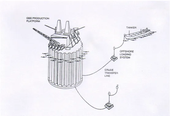
To date, two fundamentally different approaches have been considered for the development of Grand Banks oil reserves, as illustrated by the Hibernia and Terra Nova production systems. Schematics of these "generic" development approaches are shown in Figures 5.1 and 5.2. Both development schemes involve subsea flowlines, tanker loading facilities and
shuttle tankers that will periodically move produced oil to market. However, the Hibernia approach is centred around the use of a fixed gravity based structure (GBS) which has integral oil storage and is designed to passively withstand all of the forces imposed by the environment, including those from extreme wave, iceberg and sea ice encounters. The benefit of this approach is that a fixed structure (with integral storage) will experience little, if any, production downtime due to adverse environmental conditions. However, the penalty is normally reflected by increased production facility costs, extended construction schedules, and longer time frames to "first oil".
The proposed Terra Nova development scheme involves a floating ship-shape production vessel with integrated storage and offloading systems (FPSO), that is designed to continue operations in most environmental conditions, but suspend production and if necessary, move off location, should extreme events occur. When iceberg or sea ice avoidance is required, the vessel’s mooring lines and risers are lowered, and the FPSO simply moves off under its own power. This approach is based upon an "active design philosophy", and reflects a high level of confidence in the experience that has been developed with floaters during exploratory drilling activities, including the ice detection and management area. Generally, the advantage of an FPSO vessel is lower capital cost and quicker on-stream times, but the penalty is the potential for more downtime due to ice and waves, and the associated loss in production. Both of these fixed and floating development approaches will involve the periodic transfer of stored oil from the production facility to ice strengthened double hull tankers via an offshore loading system, for subsequent transport to market. The tanker mooring and oil
loading arrangement that will be periodically used at the GBS is located well below the waterline (when not in use), where it will be protected from most ice influences. At the FPSO, stored oil will be transferred to shuttle tankers that are periodically tandem moored to its stern, through a conventional mooring/loading arrangement. Clearly, tanker loading operations at both types of production facilities will be susceptible to iceberg and sea ice incursions. The shuttle tankers that are used within these developments will also be exposed to icebergs and sea ice during their transits to and from market and will be designed to contend with sea ice occurrences, but will have to avoid icebergs and small glacial ice masses (with the possible exception of very small features). Supply vessels working in the area will also be susceptible to the influences of sea ice and small ice mass occurrences.
Because the Grand Banks waters are relatively deep, the risk of seafloor scour is generally low. However, most of the subsea facilities that are associated with developments will have to be designed to accommodate the risk of iceberg scour, through placement within glory holes or trenches excavated on the seafloor. Here, it is important to note that iceberg scouring is a key constraint on pipeline transportation systems and therefore, on potential gas developments. If the sea floor was not subject to iceberg scouring, it is more likely that oil and gas pipelines would be used.
Decisions about the best type of development system for a given field are normally based upon an assessment of capital cost requirements, comparative economics and relative risks, which balance downtime, lost production and increased operating expenses for floaters against the increased capital cost and implementation schedules for fixed platforms.
6.0
Development Scenarios
In order to identify the range of ice-related problems that different Grand Banks development systems will have to contend with and in turn, assess their relative importance, representative development scenarios must first be defined. One approach is to select scenarios from existing Grand Banks discoveries and the specific development schemes now being considered, such as the Hibernia and Terra Nova projects. The other approach is to establish representative scenarios in a more generic manner, with the objective of spanning a wider range of field development possibilities. This latter approach has been adopted for this work, since it is considered to be more appropriate to PERD’s R&D planning needs. In basic terms, the definition of representative Grand Banks development scenarios involves the following two areas of consideration:
• the assumptions that are made about oil field sizes, the water depths in which they are located, and the severity of the ice conditions that these assumed field areas will be exposed to.
• the assumptions that are made about the particular development schemes that will be used to produce oil from these fields.
In this section of the report, the Grand Banks discoveries that have been made to date are briefly reviewed, to provide some background for the generic development opportunities that have been assumed. Based on these discoveries, a number of representative oil development opportunities are then defined. These generic cases are intended to span a realistic range of oil field size and water depth combinations that should be expected for future Grand Banks oil developments, in a parametric manner.
Since the ice conditions experienced in any given field location may influence the type of development approach that is selected for the field, key variations in the iceberg and sea ice climate seen across the Grand Banks are also highlighted. The development approaches that could be used to exploit these generic Grand Banks oil fields are then outlined, followed by a definition of representative Grand Banks development scenarios.
These composite scenarios combine oil field size, water depth and a particular development approach into a number of representative development cases that are used as a basis for the ice problems assessment work given in subsequent sections of this report.
6.1
Development Opportunities
6.1.1 Significant Discoveries
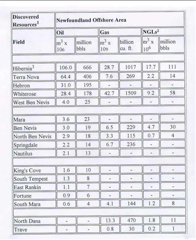
As outlined earlier, seventeen significant hydrocarbon discoveries have been made on the Grand Banks to date, in water depths ranging from 80m to 160m. These discoveries, together with estimates of their oil, gas and natural gas liquid reserves, are summarized in Table 6.1 Their geographical locations are shown in Figure 6.1. It may be seen that eight of these fields contain oil only, two are exclusively gas, and the remaining seven contain both oil and gas. Most of the proven oil reserves on the Grand Banks are located in the Hibernia, Terra Nova, Hebron and Whiterose fields, with the other existing oil discoveries being quite small. Here, it is also important to note that all of these fields lie in fairly close proximity to one another.
From a development perspective, it is clear that the amount of oil contained in any given field is a key factor. Obviously, the larger the oil reserve base the better. However, it is important to recognize that a variety of other reservoir factors also effect the attractiveness of potential field developments, and can strongly influence their cost. These factors include the fluid and production characteristics of the oil reservoirs comprising the field, the complexity of these formations in terms of structural style and trapping mechanisms, and the thickness, lateral extent and depth of the oil bearing zones. As an example, light high quality oil reserves that are concentrated over a small area, are located in a thick pay zone, and can be produced at high flow rates represent the most attractive situation. Typically, this type of oil field could be developed from one production platform, with a relatively small number of development wells. Alternatively, fields comprised of a variety of thin oil bearing zones that are spread over large lateral areas and are not capable of high flow rates are more difficult. A development scheme for this type of field would usually require many more producing and injector wells, and either multiple subsea well tie-backs to a production platform, or more than one platform. Clearly, these reservoir factors all play a very important role in the attractiveness of potential development projects, and on their costs and economics. Each one of the oil fields discovered on the Grand Banks to date is different, and has its own unique reservoir characteristics. In general terms, these oil fields are not particularly simple. Typically, each field is comprised of several oil formations which are fairly large in areal extent, not particularly thick, and often complex in terms of faulting. Although individual well productivities for many of the larger Grand Banks fields are reasonably high, some of the smaller discoveries may have poorer flows. A few comments about the oil fields discovered to date (Chipman, 1997) are given as follows, to provide some feel for their characteristics.
Table 6.1: Significant discoveries that have been made on the Grand Banks to date, together with estimates of their oil, gas and natural gas liquid reserves (from CNOPB, 1997)
Hibernia
Hibernia is the largest oil field that has been discovered on the Grand Banks, with estimated recoverable oil reserves of 666 million barrels, and an upside potential of nearly 1 billion barrels. This discovery is well recognized as major oil field by world class standards and as the lead development project, is also acknowledged as the key to stimulating further exploration and development on the Grand Banks. The following points should be noted. • the extent, geometry and characteristics of the Hibernia oil field are quite well known
from extensive delineation drilling, testing and seismic work.
• the field is comprised of four major hydrocarbon reservoirs, including the Hibernia formation, the Ben Nevis/Avalon reservoir, and the smaller Jeanne d’Arc and Catalina formations, all of which can be “reached” by wells drilled from the GBS
Figure 6.1: Geographical locations of Grand Banks discoveries (CNOPB, 1997)
with no need for separate subsea wells.
• the Hibernia field is located in about 80m of water and is roughly 10 x 10 km in areal extent, with its oil reserves lying between 2300m and 4200m below the sea floor, mostly in the Hibernia and Ben Nevis/Avalon formations.
• production rates as high as 30,000 BOPD and 12,000 BOPD are expected from
individual development wells in the Hibernia and Ben Nevis/Avalon reservoirs respectively, with potential production from the field’s smaller formations requiring further evaluation as development wells are drilled.
Terra Nova
Terra Nova is the second largest oil field that has been found on the Grand Banks to date, with estimated recoverable reserves of 405 million barrels and good upside potential for a larger reserve base. It is located about 40 km to the southeast of the Hibernia field and is also recognized as a substantial oil discovery by world class standards. Here, the following points should be noted.
• the nine wells that have been drilled in the Terra Nova field indicate significant oil reserves, although further delineation drilling is required in the field’s far east section to confirm the reserve potential in this area.
• this field is comprised of the Terra Nova reservoir. which is the largest oil formation, and the smaller Beothuk formation, which is quite heavily faulted.
• the field is located in 93m of water and is about 8 x 10 km in lateral extent, with its oil reserves lying between 3200 and 3500m beneath the sea floor.
• production rates as high as 20,000 BOPD are expected from individual development
wells in the Terra Nova reservoir.
Hebron & Whiterose
The Hebron and Whiterose oil discoveries, with current reserve estimates in the order of 150 to 200 million barrels, are the two more moderately sized oil fields that have been found on the Grand Banks. However, both fields require further delineation drilling to better define their reserve potential.
The Hebron field, with estimated recoverable oil reserves of 195 million barrels, is located in close proximity to Terra Nova, lying about 15 km to its northwest. It is believed to be the third largest oil field found in the Jeanne d’Arc Basin to date, but will require considerably more delineation. With regard to Hebron, the following points should be noted.
• the Hebron field is comprised of oil in the Jeanne d’Arc, Fortune Bay, Hibernia and Ben Nevis reservoirs, with the first three formations containing better quality oil. • the West Ben Nevis and Ben Nevis discoveries, where oil has also been tested, are
located in close proximity to Hebron’s eastern flank, but appear to contain heavier, more viscous, poorer quality oil.
• geologically, the Hebron field is quite faulted, but involves relatively large simple fault blocks.
• the field is located in about 94m of water and is roughly 8 x 4 km in lateral extent, with its oil reserves lying between 1800 and 4400m below the sea floor.
• individual well productivities in the Hebron field are not well known without further delineation drilling, but will probably be in the 10,000 to 15,000 BOPD range. The slightly smaller Whiterose field is located on the northeastern part of the Grand Banks, about 50 km away from the Hibernia and Terra Nova fields. Recoverable oil reserves from Whiterose are estimated at about 180 million barrels. Although five wells have been drilled in the field area to date, it is a large geological structure which has only been lightly delineated to date. The following points should be noted
• the Whiterose field is comprised of the South Mara, Ben Nevis/Avalon, Hibernia
and/or Rankin oil reservoirs, with most of the oil being concentrated over a relatively small thick pay zone area in the Ben Nevis formation, which enhances its development potential.
• the field is located in roughly 110m of water and is about 7 x 5 km in lateral extent, with its oil formations located between 3000 and 3900m below the sea floor. • since the permeability of the major Ben Nevis reservoir at Whiterose is relatively low,
the field’s development wells are not expected to be highly productive, with expected flow rates of 10,000 to 15,000 BOPD.
Minor Fields
In addition to the four major oil fields highlighted above, ten smaller oil discoveries have also been made on the Grand Banks. These minor fields, which include discoveries like Ben Nevis, Mara and King’s Cove, are felt to collectively contain recoverable oil resources of about 130 million barrels. Typical reserve estimates for the smaller oil fields are in the 10 to 30 million barrel range, with well productivities expected to be quite low. Some of these reservoirs include fairly sizable quantities of gas and condensates while others, like the Trave and deeper water North Dana fields, are felt to contain gas and condensates exclusively. Since most of these smaller fields are the result of one discovery well only, their current oil reserve estimates are uncertain and could change considerably, should further delineation drilling be carried out.
There is no shortage of Grand Banks development opportunities, in addition to the Hibernia and Terra Nova oil fields. At a minimum, the Hebron and Whiterose fields each have a large enough resource base to qualify them as stand-alone development project candidates. The smaller fields do not appear to contain the oil resources to justify stand-alone development. However, they may be quite attractive as individual satellite fields tied back to an existing production facility, or in combination, when considered as candidates for simultaneous or sequential development. It is not unlikely that future exploration will also result in a number of new oil field discoveries, some of which may be quite sizable.
6.1.2 Generic Oil Fields
The range of reserves that have been found in the Grand Banks oil fields discovered to date, together with the water depths in which these fields are located, provide a basis for defining representative Grand Banks development opportunities. The generic oil field cases that have been selected for use in this study include:
• five different fields, with recoverable oil reserves of 50, 150, 250, 350 and 500 million barrels.
• four different water depths for each of these fields, 80, 100, 120 and 160m.
When parametrically combined, these representative oil field selections translate into twenty separate development opportunity cases. These twenty cases are intended to span a realistic range of oil reserve and water depth combinations that should be expected for future Grand Banks developments, in a parametric manner. Specific assumptions about the reservoir
characteristics of these generic oil fields have not been made. However, typical oil field dimensions, well productivities and development drilling requirements have been established on the basis of current Grand Banks and other world wide experience, as outlined later in this report.
The prevailing industry view is that fields with recoverable oil reserves in the 200 to 300 million barrel range will be required to justify future Grand Banks developments. In addition, it is generally felt that floating production systems represent the only real alternative for these potential developments. Conventional industry wisdom also suggests that oil fields of at least 500 million barrels will be required to justify any more fixed structure developments, and that future discoveries of this size are unlikely. Industry also recognizes the potential for smaller Grand Banks oil resources to be economically tied back to existing facilities, but is seen as a longer term opportunity area. Here, it is interesting to note that in other areas of the world, oil fields of less than 100 million barrels are now being developed with floating systems. Fixed structures are also being used to develop more moderately sized fields, with reserves in the 200 million barrel range. In addition, the technology to produce satellite fields through subsea tie-backs has developed rapidly, and is routinely being used to develop small field reserves (10 to 50 million barrels) that are present around either fixed or floating production facilities.
The generic oil field cases defined for this study encompass a sufficiently wide range of Grand Banks development opportunities to allow all of these potential development alternatives to be considered. One challenge is to improve technology for Grand Banks developments to the point where relatively small oil field reserves can be economically produced, as is now being done in some of the more conventional open water areas of the world.
6.2
Ice Climate
It is clear that future developments on the Grand Banks will be exposed to different iceberg populations and sea ice occurrence frequencies, depending upon where they are located in the area. Because these ice conditions may influence the type of development approach that is ultimately selected for any given field, key variations in the iceberg and sea ice climate across the Grand Banks region are highlighted here. Obviously, oil fields that are situated in close proximity to one another and in similar water depths will not see much variation, at least in a statistical sense. However, more widely separated field areas may. For example, prospects that lie in deeper water areas towards the north and east sides of the Banks will experience more frequent and larger icebergs than in its shallower central and southern portions. This factor will effect the iceberg impact design loads used for fixed production
structures, and will influence the downtime related to iceberg avoidance for floating production systems. Similarly, potential developments in the more northerly areas near Whiterose will be subjected to higher pack ice occurrence frequencies than those near Terra Nova and as a result, may incur substantially more sea ice related downtime. It is important to recognize these ice factors before considering various Grand Banks development alternatives.
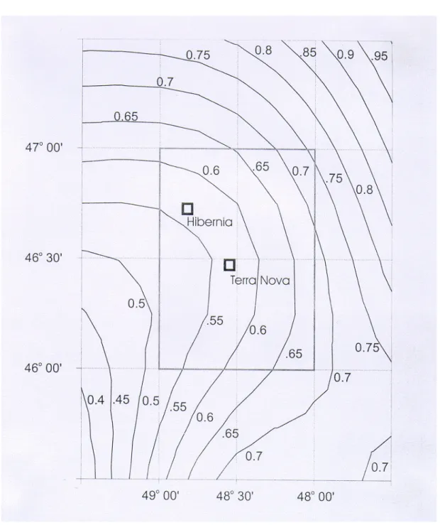
6.2.1 Icebergs
Figure 6.2 shows iceberg densities across the Grand Banks, as derived from International Ice Patrol data (Fuglem, 1997). Although the iceberg occurrence statistics that are given in this figure are not intended as precise estimates, they do illustrate some of the major trends. The following points should be noted
• the distribution of iceberg densities on the Grand Banks does vary, with expected berg occurrence frequencies in the northern and eastern reaches of the area being about 50% higher than in its central and southern areas.
• some of the icebergs that are seen in these more exposed and deeper water portions of the Grand Banks will be large, because grounding will not filter them out. • in short, iceberg populations that will influence the development of prospects in the
general vicinity of Whiterose, the West Bonne Bay location where Amoco is now drilling, and along the east flank of the Grand Banks, may have a somewhat more pronounced effect on development schemes than those found near the Hibernia and Terra Nova oil fields.
Figure 6.2: Average iceberg densities expected at any point in time across the Grand Banks, as derived from International Ice Patrol data from 1960 to 1974 (Fuglem, 1997)
6.2.2 Pack Ice
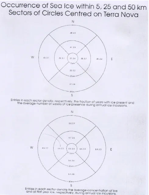
Figure 6.3 highlights some pack ice occurrence statistics for the Grand Banks, as presented in PetroCanada’s recent Terra Nova Development Project Submission. These statistics are based upon Atmospheric Environment Service observations from 1963 to present, and show expected occurrence frequencies, durations and concentrations for pack ice intrusions, relative to the Terra Nova location. The distance scales given encompass most of the Grand Banks discoveries made to date. Here, the following points should be noted.
• pack ice occurrences in the immediate vicinity of Terra Nova are only expected in about one of four years, with mean occurrence durations of about two and a half weeks, and mean concentrations between 5 and 6/10ths.
• further to the north, towards the Hibernia and Whiterose fields, and to the east, pack ice intrusions are more frequent, with occurrence frequencies of about one of two years and mean durations of three to four and a half weeks.
• in some of the poorer ice years that have been experienced on the Grand Banks, pack ice has sometimes persisted for several months at potential development locations, often in concentrations as high as 7 to 9/10ths.
• the pack ice found on the Grand Banks is not particularly severe, typically containing first year ice type concentrations of about 3/10ths and many thin ice areas, but its movement rates can be very high.
• pack ice occurrences will have a more pronounced effect on oil field developments on the north and east portions of the Grand Banks like Whiterose, than the more southerly locations like Terra Nova.
The effect of variations in expected iceberg and pack ice conditions across the Grand Banks is not explicitly addressed for the development scenarios considered in this report. However, their impact on the design and operation of various development system alternatives for different water depths is recognized, and treated as a cost and downtime sensitivity. The potential for long term climate related variations in Grand Banks iceberg and pack ice conditions over several decades (comparable to development project lifetimes) should also be noted here, in view of the global climate change and “presumed global warming” issue. Recent temperature data for the East Coast appears to indicate a cooling trend (Marko, 1995). It is conceivable that Grand Banks development systems which rely on minimal ice being
present may have to contend with more ice than the long term averages would suggest.
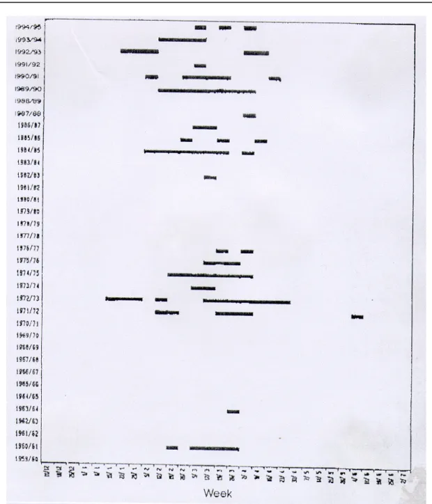
Figure 6.3a: Some pack ice occurencies statistics for the Grand Banks, as presented in PetroCanada’s recent Terra Nova Development Project Submission (1997).
Figure 6.3b: Weekly instructions of all pack ice within 50 km of the Terra Nova location, from PetroCanada’s recent Terra Nova development Project Submission (1997).
6.3
Development Approaches
6.3.1 General
Any offshore development project is comprised of a number of basic components. The major technical elements of a typical offshore development include:
• the production platform that is selected, either fixed or floating.
• the topsides facilities that are installed on the platform, including the production and accommodation modules and, in the case of fixed structures, the drilling module. • the development wells that are drilled, including both producing and injector wells.
- for fixed production structures, these wells are normally drilled from a
drilling facility onboard the platform, after it has been installed in the field area
- since floating production systems do not normally have drilling facilities, these wells are usually drilled from separate floating drilling vessels, often before the production system has been moored in the field area
• the subsea systems that may be required, including wellheads, manifolds and
flowlines.
• the export approach that is adopted, either by pipeline or tankers, including:
- any integral storage that is designed into the production platform or any of the separate field storage systems that may be put in place
- the tanker loading system and tankers that are selected, should the marine
export approach be used.
The cost of any offshore development project is strongly affected by the water depth in which it is located, the environmental conditions that it is exposed to, and the development approach selected. Platform costs are most sensitive to the operating environment, while subsea and export system costs are driven by both the operating conditions and the complexity and size of the development. Topsides and development drilling costs, which can be very high, are largely independent of the environment and are driven by process and reservoir requirements.
6.3.2 Development Options
Companies that are developing offshore oil fields have three main options. They can either build a fixed platform, deploy a floating production vessel, or install a subsea system for satellite fields that is tied back into an existing production facility. In conventional open water areas, the normal means of developing moderate to larger sized oil fields in shallow to intermediate water depths (out to about 100m) is to use a fixed platform, which is constructed of either steel or concrete. Fixed platforms are attached to the seafloor by piles or, in the case of gravity based structures, through their own weight. In open water, requirements for the structural strength and base shear resistance of fixed platforms are usually governed by the maximum wave loads expected. However, on the Grand Banks, fixed platforms will also have to withstand any iceberg collisions that may occur over their lifetime. The threat of icebergs virtually eliminates the possibility of using the type of light weight, low cost, multi-legged jacket or jack-up platforms that are commonly employed in conventional areas. This leaves fairly massive GBS structures as the only real fixed platform option for the Grand Banks.
One challenge for these GBS designs is to develop platform shapes that can effectively resist large iceberg impact loads, without attracting excessively high wave forces. On the Grand Banks, typical iceberg collision return periods for fixed structures are in the 10 to 15 year range and, in its northern and eastern areas, may involve maximum iceberg sizes up to 12 million tonnes. Over the central portion of the region, around the Hibernia and Terra Nova locations, water depths in the 80m to 90m range limit the maximum size of the design iceberg. As an example, the Hibernia platform was designed to withstand an iceberg impact energy which corresponds to a 6 million tonne berg moving at 0.6 m/sec. However, the massive size of this cylindrical GBS, along with its outer wall tooth design, represents a disadvantageous form for wave loads. As a result, both the design wave and iceberg loads for the Hibernia structure are very high, and are estimated to be very close to the same 1600 MN value. This design load level has resulted in a very capable GBS platform, but also a very costly one.
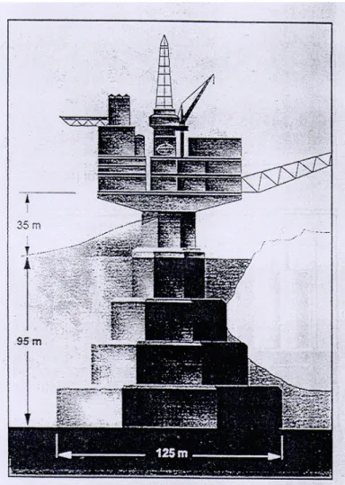
Improved structure concepts that provide good functionality for the platform’s topsides, storage, and its floating stability, while reducing both iceberg and wave loads, are desirable. These objectives have been pursued by Amoco in a recent Steel Stepped Gravity Platform design for the Grand Banks (Fitzpatrick & Kennedy, 1997). Their SSGP concept, shown in Figure 6.4, is optimized to reduce the effect of iceberg and wave loads on the platform and its foundation. By necking down the structure’s size through the waterline, design wave loads are reduced to about 1000 MN, while probabilistically derived iceberg impact design loads
are estimated at roughly 900 MN (or lower). This fixed structure concept is considerably less costly than the Hibernia GBS platform, and appears to be a very attractive alternative for Grand Banks developments, in water depths out to about 100m.
Figure 6.4: Amoco’s recent Stepped Steel Gravity Platform design for a Grand Banks location in 95m of water (Fitzpatrick &Kennedy, 1997).
As water depths increase, floating development systems usually become a more cost effective option than using fixed production structures. Floating development systems consist of one or more surface vessels and a system of subsea wellheads, flowlines and manifolds, connected to the surface facility by risers. The use of floating vessels has become a well established means of developing offshore oil fields in a wide range of water depths. For
example, the first oil produced in the British sector of the North Sea was brought on stream by a spread moored semi-submersible in 1975, at the Argyll field in 79m of water. Floating production vessels are based on semi-submersible or conventional ship-shape designs and unlike fixed structures, they are not particularly cost sensitive to water depth. Semi-submersibles have the advantage of reduced motions in high seas and their responses are not effected by changes in the wind and wave direction. However, because semis do not have onboard storage, produced oil must be continuously transferred to a separate storage vessel or to a pipeline. Ship-shape vessels have the advantage of being able to incorporate significant onboard oil storage and generally have greater surface areas and deck load capacities for their topsides. However, ship-shapes are more responsive to waves than semis, and usually need to weathervane into high seas to minimize their motions and maintain production. This requires a turret mooring system with a multi-pass fluid swivel arrangement to allow vessel rotation. Either type of vessel positions itself over subsea facilities and maintains location on a mooring system, often supplemented by dynamic positioning. These floating systems provide an attractive method of exploiting moderate to smaller sized oil fields in a range of water depths, but are more susceptible to hostile wind and wave conditions than fixed platforms.
Tension leg platforms are another option that should be mentioned for floating production. These platforms are tethered to the seafloor by a taut vertical mooring arrangement, and are often preferred for very deep water applications, in the order of several hundred metres or more. However, TLPs are not designed to be capable of easily moving off location and as a result, are not considered as a viable alternative for Grand Banks developments. This leaves semi-submersible and ship-shape vessels as the only real floating production candidates.
On the Grand Banks, these floating production vessels will be exposed to occasional iceberg and pack ice occurrences, as well as severe weather and wave events. These ice influences will also result in some downtime and from a structural design perspective, will require some level of ice strengthening on production vessels. Since the mode of operation for most floating systems will be to avoid icebergs and possibly, some heavy pack ice situations, a quick shut down, disconnect and vessel move-off capability will be important, to mitigate ice-related risks and minimize downtime. This quick disconnect requirement is a key technical challenge, particularly for turret moored vessels with a large number of production risers. However, the turret system that is now being designed for the Terra Nova FPSO is intended to enable orderly disconnect operations to be implemented over periods of four to five hours.
Here, the ice detection, ice alert and ice management procedures that have been developed during exploratory drilling operations on the East Coast should be noted, since they provide