Building Community Resilience to Climate Change with Facilitated, Collaborative Dialogue: Evaluating the VCAPS Process
By Zoë McAlear
B.A. in Growth and Structure of Cities Haverford College
Haverford, PA (2016)
Submitted to the Department of Urban Studies and Planning in partial fulfillment of the requirements for the degree of
Master in City Planning at the
MASSACHUSETTS INSTITUTE OF TECHNOLOGY May 2020
© 2020 Zoë McAlear. All Rights Reserved
The author hereby grants to MIT the permission to reproduce and to distribute publicly paper and electronic copies of the thesis document in whole or in part in any medium now known or hereafter created.
Author________________________________________________________________________ Department of Urban Studies and Planning
May 13, 2020
Certified by ___________________________________________________________________
Professor Lawrence Susskind Department of Urban Studies and Planning Thesis Supervisor
Accepted by___________________________________________________________________ Ceasar McDowell Professor of the Practice Chair, MCP Committee Department of Urban Studies and Planning
Building Community Resilience to Climate Change with Facilitated, Collaborative Dialogue: Evaluating the VCAPS Process
By Zoë McAlear
Submitted to the Department of Urban Studies and Planning on May 13th, 2020 in Partial Fulfillment of the Requirements for the Degree of Master in City Planning
Abstract
As communities around the world experience greater impacts from climate change, collaborative adaptation planning efforts are crucial to preparing for the future. This research examines one of these efforts, a pilot of the Vulnerability, Consequences, and Adaptation Planning Scenarios (VCAPS) technique by Western Water Assessment (WWA) at the University of Colorado Boulder across six communities in Colorado and Utah. The VCAPS process facilitates conversations amongst local decision-makers using collaboratively-built causal diagrams to understand how a hazard leads to specific outcomes and consequences, which correspond to potential points of intervention or actions. Using a survey and two series of interviews with participants, as well as documentation from the workshops, this research assists in the evaluation of WWA’s six pilots. The questions guiding this research ask to what extent the VCAPS process better prepared the pilot communities to face their identified climate hazard(s), in terms of increased motivation, ability to overcome challenges or barriers to adaptation, and actions generated or influenced by the workshop. I find that these six pilot workshops demonstrate the potential of the VCAPS process to inform participants’ understanding of their region’s climate change risks and generate climate adaptation-related actions in their communities. At the same time, feedback and reflections from participants suggest various ways in which the process might be adapted for future iterations in order to respond to current challenges or limitations. I propose recommendations to address these, often relying on examples of other collaborative climate adaptation processes.
Thesis Supervisor: Lawrence Susskind
Acknowledgments
This thesis only exists thanks to everyone who made my summer work in Utah possible. Thank you to the Priscilla King Gray Public Service Center at MIT for providing funding, guidance, and support. And to Danya Rumore, at the Wallace Stegner Center’s Environmental Dispute Resolution Program at The University of Utah. Danya, I really appreciated the opportunity to learn from you and your work, and am grateful to have had your support and advice throughout the thesis-writing process.
Additionally, thank you to everyone at Western Water Assessment at the University of Colorado Boulder for giving me the opportunity to participate in your work with the VCAPS process. I am so grateful for all of the support and feedback provided by Benét Duncan, Seth Arens, Lisa Dilling, and Katie Clifford. Thank you especially to Benét, for being so generous with your time and answering every one of my questions along the way. I hope that this research proves to be a useful resource for all of you.
I am grateful to all of the VCAPS participants who completed the survey and interviewed, for giving your time to help benefit future VCAPS communities.
Thank you to Lawrence Susskind, my advisor, for your guidance through every step of this project, and in all of the steps leading up to it. Over these two years, I have learned a lot from you and your pushes to keep me questioning. And to everyone else who has supported me at DUSP – it has been a pleasure to learn alongside all of you.
Lastly, thank you to Matías, who became my unexpected colleague during these months of isolation due to COVID-19 for your support and accountability from the other side of our kitchen table.
Abstract ... 3
Acknowledgments ... 5
Introduction ... 9
Objective of Research ... 10
Background and Context ... 12
Vulnerability, Consequences, and Adaptation Planning Scenarios... 12
Western Water Assessment’s Pilot VCAPS Workshops ... 15
VCAPS-Related Research ... 17
Methodological Approach ... 21
Western Water Assessment’s Survey... 21
Interviews ... 21
Key Findings and Analysis ... 23
Context and Outcomes of the Community Workshops ... 23
General Survey Findings ... 42
Analysis of Community Workshops ... 43
Recommendations and Conclusions ... 50
Overall Findings & Recommendations ... 50
Additional Reflections ... 68
Conclusions ... 69
References... 73
Appendix A: List of Interview Citations ... 76
Appendix B: Western Water Assessment’s Follow-Up Survey ... 77
Appendix C: Western Water Assessment’s Interview Guide... 80
Appendix D: Interview Guide ... 82
Introduction
Water supply providers and government officials in the Spanish Valley/Moab region in Utah have begun to notice increased variability in their weather from year to year, and increased exposure to extremes in temperature and precipitation. The region experienced a historic drought in 2018, with extremely low snowfall that resulted in reduced runoff and water availability. The following year, 2019, was an extremely wet year, with a large winter snowpack and an extended cool and wet period in the spring. This increasingly extreme variability has left decision-makers unsure of how to best manage water supply in the region, and what actions they can take to minimize their
vulnerability and prepare for the future. In this context of uncertainty, a local decision-maker heard about a research program, Western Water Assessment (WWA) at the University of Colorado Boulder, that was running pilots of a process designed to increase a community’s resilience to weather and climate impacts, and invited them to the Spanish Valley/Moab region. The decision-maker hoped that this process, which focuses on knowledge-sharing and collaborative dialogue, would help to facilitate conversation and joint action around the issues caused by drought in the region.
WWA accepted the invitation and held a community workshop with stakeholders in the Spanish Valley/Moab region as the sixth such pilot in the Mountain West of the process known as “Vulnerability, Consequences, and Adaptation Planning Scenarios” (VCAPS). Following extensive pre-workshop preparation and interviews with all of the participants, a WWA climate scientist and a facilitation team traveled to Moab in July 2019 to run the workshop. Over two days, the group was first presented with regionally-focused climate science observations and projections, and then worked together to map out the potential outcomes and consequences of the local climate hazards, before jointly identifying possible responses or actions. As a closing for the workshop, participants shared the action that they planned to move forward individually or within their organization, and the action they most hoped the group would work on collectively. Following the workshop, the participants returned to their daily jobs and responsibilities, potentially continuing to think about the issues discussed through the process, but also shifting focus back to other pressing concerns. The question then is: what happened next? Did the VCAPS workshop have a lasting effect on the Spanish Valley/Moab region’s resilience to climate impacts?
Objective of Research
This past summer, I worked as a graduate fellow for the Wallace Stegner Center’s
Environmental Dispute Resolution (EDR) Program at the University of Utah. The EDR Program assisted in the facilitation of Western Water Assessment’s VCAPS workshop in the Spanish Valley/Moab region discussed in the introduction, and I was able to contribute to and observe the effort. Now working with WWA as my thesis client, I aim to assist them with evaluation of this pilot workshop, and five others from 2018, to understand the workshops’ impact on each community and how the VCAPS process could be improved for the future. WWA is currently deciding whether to continue using VCAPS as a tool in communities and, if so, what changes might be made to make it more useful and meaningful for its participants.
The VCAPS process is a tool for collaborative planning around climate change adaptation. It connects education and knowledge-sharing with outcome-focused discussion. The questions remain, though, of whether these collaborative conversations result in tangible actions that make the
residents and infrastructure safer and more resilient, and how else we should measure the tool’s effectiveness and utility. Additionally, if the workshops are not resulting in actions as an outcome, how can the process be adapted to better support participants in taking the actions they identify?
The mission of Western Water Assessment is to “conduct innovative research in partnership with decision-makers in the Rocky Mountain West, helping them make the best use of science to manage for climate impacts” (Western Water Assessment). The second part of this mission aligns with the general goals of the VCAPS workshop, which are, as I understand them, to: 1) share region-specific, usable science with workshop participants; 2) increase collaboration between the different entities that are present; and 3) catalyze adaptation-related planning and projects by collaboratively identifying short- and long-term actions and strategies.
At the center of this process is WWA’s self-definition as a boundary organization, meaning that, for them, it is the co-development of usable science, through iterations of communication and collaboration with decision-makers, that will affect change (Dilling, Clifford, Mcnie, Lukas, & Rick, 2008; Kirchhoff, Lemos, & Dessai, 2013; Mcnie, 2007). Researchers from WWA write that, as a boundary organization, they “act as a two-way conduit between decision-maker communities and the research community. They mediate the transfer and creation of knowledge and buffer each side of the boundary from potential negative consequences such as the politicization of science” (Dilling, Clifford, Mcnie, Lukas, & Rick, 2008: 9). WWA was interested in incorporating the VCAPS process into their work with communities because it fits into their self-identified role as a boundary
organization; these workshops are an opportunity to share scientific climate information with stakeholders, as well as a tool to then allow the group to collectively filter that information through their own knowledge and experience, to make it meaningful and usable for their work as a
community. For this research, I accept this understanding of WWA’s role in the VCAPS process and use it as a central idea in my analysis of the outcomes and effectiveness of this method.
I am using this research, in part, to explore the connection between the communication of usable scientific information to stakeholders, and how effectively this contributes to the realization of the desired outcomes of the VCAPS process. Different theories attempt to define this
connection, but I will share two here that contain components that will emerge in later sections of this research. First, Robert Kates (2007) writes, “Accelerations in collective action requires four conditions: changes in public values and attitudes, vivid focusing events, an existing structure of institutions and organizations capable of encouraging and fostering action, and practicable available solutions to the problems requiring change” (p. xiv). Second, Susanne Moser and Lisa Dilling (2007) present a theory of communication that says, “For communication to be effective, i.e., to facilitate a desired social change, it must accomplish two things: sufficiently elevate and maintain the
motivation to change a practice or policy and at the same time contribute to lowering the barriers to do so” (p. 679).
My research through this thesis builds on the theories above, including usable science, effective communication, and how social change or collective action are catalyzed, to evaluate the success of Western Water Assessment’s six pilot VCAPS workshops in the Mountain West. I am using the following questions as a guide:
1. Does the VCAPS process, as demonstrated through these six pilots, result in tangible actions that make the local residents and infrastructure safer and more resilient?
a. If not, or not to a great extent, how could the process be modified so that its
outcomes are most useful to more participants in moving identified actions forward? 2. Did the VCAPS workshop elevate a motivation to change in each pilot community, and how
has this motivation been maintained over time in relation to realized actions?
3. To what extent did the VCAPS process provide adequate and useful information, or other types of support, that assisted each pilot community in overcoming participant-identified barriers to change?
4. What community characteristics, including before, during, and after the workshop, connect to successfully maintaining motivation over time and implementing tangible actions?
Background and Context
Vulnerability, Consequences, and Adaptation Planning Scenarios
VCAPS was developed as a joint project of the Social and Environmental Research Institute and the Carolinas Integrated Sciences and Assessments Program. The technique was first tested and refined in 2011 in two South Carolina coastal communities, before being applied in other coastal communities in Alabama, Maine, Massachusetts, North Carolina, and South Carolina (VCAPS). Additionally, training workshops have allowed the developers of the technique to teach it to other professionals who have applied it in other regions. Western Water Assessment began to pilot the technique in the Mountain West in 2018, focusing primarily on the management of drought and extreme precipitation events.
The VCAPS process’s design allows stakeholders to explore potential outcomes of climate change in their region while building relationships with each other and collaboratively identifying actions and strategies that could help increase their resilience. The process consists of three main phases: initial interviews with a local “community champion(s)” to identify one to two local
hazard(s) that are related to climate change (i.e., drought or extreme precipitation); identification of key project participants who are engaged in the community’s response to the hazard(s), and
completion of pre-workshop interviews with them; and an eight-hour workshop that is spread across two half days. The workshop itself primarily consists of two components: a one-hour presentation from a climate scientist on up-to-date local observations, climate change projections, and potential outcomes related to the chosen local hazard(s); and a diagramming exercise and discussion that results in one or more mapped causal structure(s) of a hazardous event, including points of intervention and potential participant-identified actions to address the mapped outcomes and consequences.
In more detail, the VCAPS diagramming exercise is conducted in real-time using the open-source program known as Visual Understanding Environment, a concept and content mapping application, on a screen in front of participants.1 The discussion begins with a management concern (i.e., drought) and climate stressor(s) (i.e., increased temperature), which have been identified as key participant concerns through the pre-workshop interviews. From that point, participants brainstorm
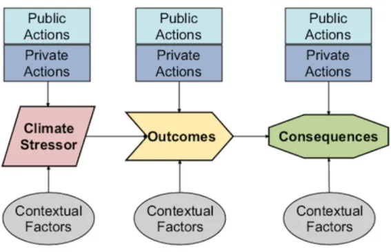
the physical and social outcomes and consequences that stem from each climate stressor. In addition, participants attempt to identify contextual factors, or the factors that are unique to the region’s context that influence its ability to cope with a particular outcome or consequence. Once they have identified some of these initial building blocks, the group begins to brainstorm potential actions that public and/or private actors in the region could take to address the different outcomes and consequences. The actions should be connected with an arrow to specific intervention points within the causal structure, to show which outcomes or consequences could be mitigated by a particular action. The diagrams use different shapes and colors for the five components, as well as arrows to show how they connect (Figure 1).
Figure 1: The Building Blocks of a VCAPS Diagram (Source: https://www.vcapsforplanning.org/process.html)
The diagrams serve primarily as a brainstorming tool. Participants contribute individual components and a WWA team member uses the diagramming software to note down contributions using the building blocks described above, connecting them with arrows as they go. The facilitator of the process (whose role will be further discussed in the following section) can then pause the brainstorming to allow participants to reflect on what they have created so far, propose changes, dispute a contribution, ask questions, etc. As the resulting diagrams are meant to be a brainstorm, there is not a particular decision rule to decide what is or is not included; if there is disagreement, participants can discuss amongst themselves to clarify their viewpoints, but contributions will remain in the diagram if a participant maintains that they should be part of the structure. The WWA climate
scientist or facilitator could choose to step in to make corrections or ask questions if they viewed a component as inaccurate but, in general, the pilot workshop teams allowed the participants to form their own conclusions on what should or should not be included (Duncan, 2020).
In their analysis of the first eight VCAPS workshops conducted on the East and Gulf Coasts, Webler (of the Social and Environmental Research Institute) et al. (2014), explain that this diagramming process has its roots in hazard management and vulnerability assessments. First, hazard management focuses on a causal stream of events, “begin[ning] with drivers and initiating hazard events, and then flow[ing] through a sequence of intermediary outcomes that end in
consequences to humans and what they value” (p. 170). Second, they see “the VCAPS process [as] a form of ‘bottom-up’ vulnerability assessment that facilitates participants’ integration of sensitivity, resilience, and adaptive capacity concepts into the causal chain of hazards” (p. 171). These two components are combined in VCAPS diagrams, which contain nodes “typically beginning with a stressor (hazard) and leading to harmful consequences that are of concern in a community,” while linking contextual factors to bring in local understandings of vulnerability and indicating potential management interventions that “represent a scenario or a plausible future that the community wants to plan for” (p. 172).2
The two-part setup of this workshop aligns with the previously-discussed role of WWA as a boundary organization. In the first part of the workshop, the presentation, the WWA researcher is the communicator of scientific research, having collected information from various sources and now summarizing it for participants to inform their understanding of how climate change is currently, and will in the future, affect their local region. During this section, though, participants are encouraged to share their personal understandings and ask questions. In the second part, after an explanation of the diagramming tool, participants then take the lead on incorporating the presented scientific information into their own understanding of their local environment to collaboratively brainstorm the components of the causal structures. The first part of the workshop is primarily one-way communication from researcher to community members, but the second part of the workshop is driven by the participants themselves with the guidance of a facilitator. This setup raises important
2 Throughout this research, the causal diagrams produced in the VCAPS workshops are sometimes referred to as
“scenarios,” but this explanation of the process’s roots in hazard management and vulnerability assessments should help to distinguish the diagram and workshop’s function from scenario planning, which generally moves beyond representing a scenario or a plausible future (as stated here) to “develop[ing] a series of initiatives, projects, and policies that may help support a preferred scenario, a component of a scenario, multiple scenarios, or all scenarios” (American Planning Association).
questions both about the facilitation of the workshop, as well as about the identification of
participants. These two components will be further discussed in the context of WWA’s pilots in the following section.
Western Water Assessment’s Pilot VCAPS Workshops
Western Water Assessment conducted five community workshops in 2018 as part of their official pilot of the VCAPS process in the Mountain West, as well as an additional workshop in July 2019 at the request of a community member from Moab, Utah. WWA conducted these workshops as part of their federally-funded work through the National Oceanic and Atmospheric
Administration’s (NOAA) Regional Integrated Sciences and Assessments (RISA) Program. Every five years, WWA must apply to qualify for funding and, if funded, they receive one-fifth of that funding each year until they must apply again. During those five years, WWA has discretion over how that funding is spent, but they must maintain consistency with their original proposal. When WWA applied for funding five years ago, they included a pilot of the VCAPS method in Colorado as part of their application, which is what allowed them to fully fund the five original community workshops. As will be explained in further detail below, a facilitator external to Western Water Assessment worked on the two Utah workshops, and was thus not covered by WWA’s funding through the RISA Program; instead, this work was done pro bono for the
Springdale/Rockville/Hurricane workshop and was paid for between various agencies for the Spanish Valley/Moab region workshop.
One or more “community champion(s)” assisted Western Water Assessment in planning each workshop, by helping to identify a list of potential participants and decide on the content and/or focus of the workshop. The community champions were identified in different ways. First, WWA submitted a blurb to the Colorado Municipal League’s newsletter advertising their VCAPS pilot program and searching for communities that would be interested in participating.3
Representatives from the municipalities of Cortez and Durango responded and both ended up as the community champion for their respective workshop as they were directly involved in climate planning in their community and had the capacity to convene local participants (Duncan, 2020). Second, WWA used personal connections to find other interested communities and brought on
3 The Colorado Municipal League is a consortium of Colorado municipalities with a mission of “Advocacy, information,
Carbondale and Routt County in Colorado and Springdale/Rockville/Hurricane in Utah as the other three pilot communities. For these three workshops, the personal connection either became the community champion or helped connect the WWA team to another local stakeholder who had more political and social capital to convene participants (Duncan, 2020). Lastly, as previously stated, after these initial 2018 pilots, a community stakeholder in Moab, Utah reached out to WWA to ask if they could participate, and a sixth workshop was held there in 2019. This stakeholder became the
community champion for the Spanish Valley/Moab region workshop, as they had strong professional connections in the area with a range of stakeholders. In addition to the primary
community champion described for each workshop above, some communities included a second or third community champion at their discretion.
Regardless of how the community champion was identified, they spearheaded the process of identifying workshop participants. In an interview with Benét Duncan of WWA, she explained that WWA would assist them if they had questions on how best to identify participants, but otherwise let the community champion lead the process (Duncan, 2020). Additionally, community champions were given guidance, based on advice from the developers of the VCAPS process, that the ideal group size was ten to fifteen individuals. As each community champion was responsible for the process of identifying participants in their community, each group of participants was likely chosen using a different methodology. In general, the VCAPS workshops piloted by WWA engaged community decision-makers who are directly involved in the operation of the systems most directly affected by the identified local hazard(s), or in the response to the hazard(s), and, thus, most able to advance climate adaptation planning in their community. Stakeholders varied at each workshop but included members of local planning commissions and city councils; city staff; county commissioners, board members, and staff; state- or national-level Forest Service and Bureau of Land Management staff; water provider board members and staff; as well as representatives of other stakeholder groups, such as environmental advocates and/or agricultural producers. In the end, the community champion(s), as well as the willingness and/or availability of their invitees to participate, determined the makeup of the final group for each workshop.
In addition to the community participants, it is important to further introduce the Western Water Assessment team members who contributed to each workshop, and how each of their roles impacted the process. First, each workshop had a WWA researcher who gave the climate science presentation and answered technical or scientific questions throughout the discussion. Second, a team member worked as the diagrammer, translating participants’ brainstorm contributions into the
diagram software and organizing components as the discussion continued. Third, another individual was a notetaker with the role of collecting a transcript of the meeting to inform the workshop’s report and to assist the diagrammer in keeping up with the conversation. Lastly, each workshop had a facilitator whose primary responsibilities were keeping the group on task and following the agenda, ensuring that all participants were able to contribute, and guiding the participant-driven discussion through the different components of the causal structure for each hazard. Various WWA employees facilitated the first four workshops in Colorado, primarily for budgetary reasons, as they were all covered by the program’s general funding from NOAA. Each of these four workshops had a
different facilitator, as the WWA team thought that it was a good opportunity to give team members experience facilitating and build their team’s capacity for the future (Duncan, 2020).
The first WWA facilitator for Durango had previous formal facilitation training through NOAA and experience facilitating small and large meetings. After the first workshop, she shared materials from her past facilitation training with colleagues that would facilitate in the future. In addition, the team ran simulations of the workshop for facilitators (and diagrammers) to practice the role (Duncan, 2020). Following these initial four workshops, the final two workshops in Utah were both facilitated by Danya Rumore of the Environmental Dispute Resolution Program at the University of Utah, who has extensive professional experience in facilitation and mediation. Additionally, Danya received guidance from the previous facilitators through a conversation about the goals of the workshop and potential difficult moments in the agenda (Duncan, 2020).
In addition to the distinctions discussed above, including who were the community
champion(s), participants, and facilitators, the six workshops varied greatly from each other, in terms of what and how many units of government participated in the workshop, how many and what hazard scenarios they discussed, and the general community and environmental context of each. In addition, each of the workshops varied in terms of what follow-up has occurred since the workshop, what types of actions have or have not been completed, and how participants reflect on their
experience. For a more in-depth exploration of each community’s context, and an analysis of how the six workshops, and their outcomes, compare and contrast, see “Key Findings and Analysis.”
VCAPS-Related Research
This review and evaluation of Western Water Assessment’s VCAPS pilots in Colorado and Utah fits within two existing bodies of academic research: previous academic research on the VCAPS process and research on other formats of community-based climate adaptation-focused
participatory processes. This section will summarize these two bodies of research, and compare and contrast WWA’s pilots with examples of these other processes. This summary aims to show that this evaluation of WWA’s pilots is important in order to provide an in-depth analysis of this new
branching of the VCAPS process into Mountain West communities, as well as demonstrate its potential as a form of community-based adaptation planning. In addition, comparison with other participatory methods helps to identify strategies and techniques that could be adapted into the VCAPS process in order to strengthen its impact on communities.
Previous academic research on the VCAPS process has primarily been conducted by the team of researchers (associated with the Social and Environmental Research Institute and/or the Carolinas Integrated Sciences and Assessments Program) who initially designed and piloted the technique. This growing body of work on the VCAPS process has three primary goals. The first goal is to introduce the VCAPS process and explain its purpose as a tool. The researchers place it within the larger framework of facilitation tools, writing, “Participatory modeling…is viewed as a way of bringing stakeholders together to organize information about complex systems into tools that are more useful for local decision-making than those designed by scientists and decision makers alone” (Tuler, Dow, Webler, & Whitehead, 2015: 25). The second goal of their work is to examine
particular pilots to determine the effectiveness and usefulness of the project, including in Dauphin Island, AL (Janasie, 2014), Sullivan’s Island, SC (Kettle et al., 2014), and South Thomaston, ME (Webler, Stancioff, Goble, & Whitehead, 2017), as well as through a comparison of multiple sites (Webler, Tuler, Dow, Whitehead, & Kettle, 2014). Specific goals and outcomes analyzed through this research include how well VCAPS: facilitates deliberative group learning, builds collaboration across governmental units, identifies locally relevant adaptation strategies, and prioritizes
management actions (Kettle et al., 2014; Webler, Tuler, Dow, Whitehead, & Kettle, 2014).
As an example of previous workshop-specific research, Nathan Kettle et al. (2014), focus on the VCAPS process conducted in Sullivan’s Island, South Carolina and use participant interviews to demonstrate its outcomes. Their overall argument is that VCAPS, as a “mediated modeling process, informed by local engagement and deliberation, support[s] risk-based management approaches for climate adaptation” (p. 29). Their research looks in-depth at the various outcomes of the
diagramming process, sharing the impacts of concern, management actions, and contextual factors that participants contributed to the discussion. Through these outcomes, and participant feedback, they seek to demonstrate that VCAPS “facilitated knowledge exchange and adaptation planning through the documentation and synthesis of existing issues, prioritization of management actions,
connection of environmental- and climate-related changes to consequences, and identification of adaptation tasks, communication strategies, and information needs among town staff” (p. 27).
As another example, Webler et al. (2014), maintain a similar argument to Kettle et al.’s, research, saying “Our findings illustrate how an analytic-deliberative process that integrates local and scientific knowledge offers great potential for adaptation planning” (p. 167). This research analyzes the use of VCAPS in eight coastal communities in South Carolina, North Carolina, Massachusetts, and Alabama, utilizing post-workshop short questionnaires and interviews to assess the outcomes of the process. They find that it enabled three positive outcomes: “helped communities to consider how climate-related stressors lead to undesirable consequences and to identify locally relevant adaptation strategies,” “helped to build collaboration across governmental departments,” and “produced outputs that could be used to justify to the public why specific management actions were important to take” (p. 179-80).
In addition to looking at self-reflective research on the VCAPS process, it is also important to note that the VCAPS process fits within a spectrum of many other community-based climate adaptation processes, with varying levels of overlap in techniques, goals, and outcomes. Aspects of VCAPS can be recognized in many of these other tools. First, some processes, such as the Climate Literacy Partnership of the Southeast and the Rural Climate Dialogues Program, focus on dialogue in order to acknowledge different points of view and build community around climate change as an issue (McNeal, Hammerman, Christiansen, & Carroll, 2014; Myers, Ritter, & Rockway, 2017). These examples differ in terms of the outcome that each professes as its goal. In contrast to the VCAPS process, the Climate Literacy Partnership of the Southeast was focused on dialogue as a mechanism of community education, as they recognized broader engagement as the first step in taking climate action since “we will not make real progress without broad input” (McNeal, Hammerman,
Christiansen, & Carroll, 2014: 632). On the other hand, the Rural Climate Dialogues Program concentrated on mobilizing action but, in contrast to VCAPS, focused on public engagement and active involvement of citizens in decision-making leading to “the production of citizen-driven recommendations or findings” (Myers, Ritter, & Rockway, 2017: 10).
Others go beyond dialogue to focus on deliberation as the key technique. An example of this is in Michigan coastal communities where a “Deliberation with Analysis” facilitated dialogue
technique was used to co-create climate change plans that ultimately led to local and regional initiatives (Crawford, Beyea, Doll, & Menon, 2018). Similar to VCAPS, this particular process was focused on incorporating “local residents’ knowledge and values with local climate data,” but
focused on the creation of local and regional climate adaptation plans in conjunction with planning departments (p. 284). While the researchers record various actions that participants note as
outcomes of the meetings, they lament that there may not have been meaningful change in terms of “learning from and respecting differences, integrating diverse views, and enhancing communication” (p. 298). As an additional technique, other methods incorporate visual thinking, including in Port Orford, Oregon, where researchers and participants used concept maps and influence diagrams to analyze the decision context, evaluate potential solutions, and make decisions (Cone, Rowe, Borberg, & Goodwin, 2013).
Lastly, other models focus more strongly on collectively imagining future scenarios, such as through scenario building or science-based role-play simulations (Murphy et al., 2016; Susskind, Rumore, Hulet, & Field, 2015). Scenario-building shares an overlap with the VCAPS method in terms of the causal structures that are at the core of each but, as noted earlier, diverges first in terms of how participants build alternative scenarios for comparison and, second, in how they then engage in future-visioning to “develop a series of initiatives, projects, and policies that may help support a preferred scenario, a component of a scenario, multiple scenarios, or all scenarios” (American Planning Association).
Further reflections on these processes, in relation to the VCAPS process and the lessons they can provide, are included in “Recommendations and Conclusions,” but a full evaluation of these other forms of community engagement in comparison to VCAPS is beyond the scope of this research.
Methodological Approach
Western Water Assessment began an evaluation of their VCAPS pilot in the summer of 2019 to determine if the process was useful for the six communities and effective in accomplishing its main goals, to decide whether or not WWA will continue using VCAPS with communities in the future. This research builds off aspects of their ongoing evaluative work, as well as explores new avenues of questioning. In addition to documents and data connected to each workshop, including pre-workshop interview summaries and workshop final reports, I rely on a WWA-conducted survey and two sets of interviews (one set conducted by WWA staff and one set I conducted myself), as described below.
Western Water Assessment’s Survey
When I began conversations with Western Water Assessment in August 2019 regarding this research project, researchers there were already in the process of developing and distributing a follow-up survey for the first five pilot workshops conducted in 2018. WWA distributed the survey in December 2019 and collected responses until mid-January 2020 (See Appendix B for the survey protocol and questions). Of the 51 participants from the five original pilots, WWA received 35 responses for a 69% response rate. The purpose of the survey, as defined by WWA, was to help researchers evaluate the effectiveness and impacts of the VCAPS process on the pilot communities. I was able to review the survey design and questions in August 2019, and I requested the addition of questions related to my particular research interests. These additional questions focused on asking participants to identify changes in their personal and community motivation to take action on the discussed hazard, whether the VCAPS process helped participants identify ways to overcome barriers to taking action, and how the workshop could be designed to do that more effectively.
Interviews
In addition to the survey, WWA researchers had initiated interviews of the community champions from the original five pilots from 2018 to supplement the short answers from the survey. A WWA researcher, Katie Clifford, conducted interviews with two participants from Routt County, two from Carbondale, and one each from Durango, Cortez, and Springdale/Rockville/Hurricane. As described in the introduction to the interview, the purpose of these interviews was to understand
what the community champions found valuable or not so valuable about the process, as well as whether or not it led to any decisions, actions, or lessons learned (See Appendix C for the interview questions). In developing my interview protocol and questions to supplement these seven
participant interviews, there was too much of an overlap in content to justify re-interviewing the same community champions, so I only reached out to additional participants for my interviews.
In total, I interviewed 16 participants with four from Durango, three from Carbondale, three from Cortez, two from Routt County, zero from Springdale/Rockville/Hurricane, and four from the Spanish Valley/Moab region. I attempted to interview a variety of stakeholders within each community (i.e., a mix of city employees, elected officials, interest group stakeholder representatives, etc.) in order to hear a range of views. Similar to WWA’s set of interviews, I described the purpose to participants as “understanding what about the process you found useful or not, and how it has or hasn’t led to actions or other outcomes for you, your organization, and your community.” I was primarily interested in asking open-ended questions to encourage the interviewees to reflect on any impacts of the VCAPS process and provide feedback on how the process could be improved to have a greater impact on other communities in the future (See Appendix D for the interview questions).
Thus, in total, my analysis draws on 23 interviews: five from Durango, five from Carbondale, four from Cortez, four from Routt County, one from Springdale/Rockville/Hurricane, and four from the Spanish Valley/Moab region. Given that I was unable to conduct interviews with
participants from the Springdale/Rockville/Hurricane workshop, my analysis in the sections below primarily focuses on the other five workshops, for which I have a relatively even number of
interviewees. However, to give some details on the Springdale/Rockville/Hurricane workshop, without generating specific conclusions from these limited data, I reference other resources including the workshop report, survey responses, and WWA’s interview with the community champion.
Key Findings and Analysis
Context and Outcomes of the Community Workshops
Before sharing general analysis from the survey, as well as central takeaways across the six workshops, this section includes important context details of each community, its workshop, and their outcomes. The two tables below provide an overview of some of the key characteristics that distinguish each of the communities and their workshop, before expanding on each one individually.
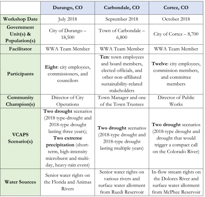
Table 1: Pilot Workshop Overview (Part A)
Durango, CO Carbondale, CO Cortez, CO
Workshop Date July 2018 September 2018 October 2018
Government Unit(s) & Population(s) City of Durango – 18,500 Town of Carbondale – 6,800 City of Cortez – 8,700
Facilitator WWA Team Member WWA Team Member WWA Team Member
Participants
Eight: city employees,
commissioners, and councilors
Ten: town employees
and board members, elected officials, and other non-affiliated sustainability-related
stakeholders
Twelve: city employees,
commission members, and committee members Community Champion(s) Director of City Operations
Town Manager and one of the Town Trustees
Director of Public Works
VCAPS Scenario(s)
Two drought scenarios
(2018 type-drought and 2018-type drought lasting three years);
Two extreme precipitation
(short-term, high-intensity microburst and multi-day, heavy-rain event)
Two drought scenarios
(2018-type drought and 2018-type drought lasting multiple years)
Two drought scenarios
(2018-type drought and drought that would trigger a compact call on the Colorado River)
Water Sources
Senior water rights on the Florida and Animas
Rivers
Senior water rights on various rivers and surface water allotment
from Ruedi Reservoir
In-flow stream rights on the Dolores River and surface water allotment from McPhee Reservoir
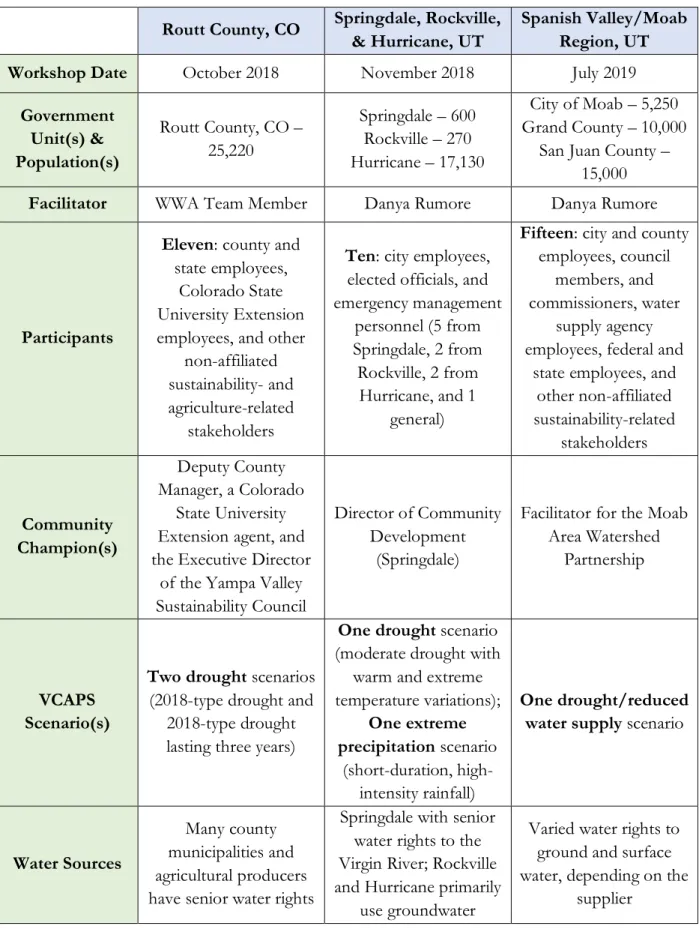
Table 2: Pilot Workshop Overview (Part B)
Routt County, CO Springdale, Rockville,
& Hurricane, UT
Spanish Valley/Moab Region, UT
Workshop Date October 2018 November 2018 July 2019
Government Unit(s) & Population(s) Routt County, CO – 25,220 Springdale – 600 Rockville – 270 Hurricane – 17,130 City of Moab – 5,250 Grand County – 10,000
San Juan County – 15,000
Facilitator WWA Team Member Danya Rumore Danya Rumore
Participants
Eleven: county and
state employees, Colorado State University Extension employees, and other
non-affiliated sustainability- and agriculture-related
stakeholders
Ten: city employees,
elected officials, and emergency management personnel (5 from Springdale, 2 from Rockville, 2 from Hurricane, and 1 general)
Fifteen: city and county
employees, council members, and commissioners, water
supply agency employees, federal and
state employees, and other non-affiliated sustainability-related stakeholders Community Champion(s) Deputy County Manager, a Colorado State University Extension agent, and the Executive Director
of the Yampa Valley Sustainability Council
Director of Community Development
(Springdale)
Facilitator for the Moab Area Watershed
Partnership
VCAPS Scenario(s)
Two drought scenarios
(2018-type drought and 2018-type drought lasting three years)
One drought scenario
(moderate drought with warm and extreme temperature variations); One extreme precipitation scenario (short-duration, high-intensity rainfall) One drought/reduced water supply scenario
Water Sources
Many county municipalities and agricultural producers have senior water rights
Springdale with senior water rights to the Virgin River; Rockville and Hurricane primarily
use groundwater
Varied water rights to ground and surface water, depending on the
Durango, Colorado:
Figure 2: Durango, Colorado (Source: The Durango Herald)
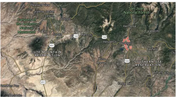
Figure 3: Durango in the SW corner of Colorado (Source: Google Maps)
Western Water Assessment’s first pilot VCAPS workshop took place in the City of Durango, Colorado in the midst of one of the region’s most severe drought events in recent history (Page et al., 2018: 4). The region has historically experienced drought on a cyclical basis, but also experiences seasonal monsoons and extreme precipitation events that pose very different challenges from drought conditions. With this in mind, this workshop’s facilitators took on the ambitious task of using the VCAPS diagramming process to explore two drought scenarios (a 2018-type drought and a 2018-type drought lasting three years) and two extreme precipitation scenarios (a short-term,
high-intensity downburst and a longer monsoon event). These discussions took place amongst eight workshop participants, all of whom were city employees, commissioners, and council members, as convened by the Director of City Operations. One interviewee emphasized the diversity of
participant interests present in the workshop, saying that it was beneficial to have individuals from many different departments, including utilities, planning, and parks and recreation (Interview 11).4 Multiple participants from this workshop affirmed that the VCAPS process had furthered their understanding of the discussed hazards, with one interviewee saying, “Everybody in the region has a broad understanding of drought, and concern of economic and other impacts of drought…but the workshop really made a more formative idea of what the outcomes could look like” (Interview 10). A survey respondent echoed this sentiment: “I had been aware of the issues and of staff work toward addressing them, but the workshop brought home to me the extreme risk we face from prolonged drought.”
The 2018-type drought conversation in this workshop focused on reduced water supply, which participants identified would then lead to three primary branches of outcomes: prioritization of water uses, reduced ecological health of the river (with cultural/economic impacts and water quality impacts), and curtailment of their primary water source (leading to increased costs to utilize their secondary water source) (Page et al., 2018: 10-13). The discussion primarily “focused on ‘upstream’ actions related to conservation that serve to mitigate all four of [those] issue areas” (p. 13). The longer-lasting drought scenario then built on this framework to focus on how to deal with “acute water supply limitations,” continuing to think about upstream conservation actions, as well as mandating restrictions (p. 14).
In terms of the second identified hazard, the less-severe extreme precipitation conversation focused on how to mitigate runoff and flooding issues in the city, including through improvements to stormwater systems and mandating flood-resilient development, with an eye towards potential water quality impacts of pollutant and sediment runoff (p. 15). The more extreme precipitation diagram built on this to primarily focus on the emergency management aspect of a larger
precipitation event (including consideration of both preparatory actions and emergency response actions) (p. 18).
At the end of the workshop, participants expressed that it had been useful to “discuss the long view” and “have structured, facilitated conversations,” and shared general next steps that they
hoped to take individually or collectively (p. 20). This group’s actions were primarily process-focused, including developing a timeline for actions and analyzing cost tradeoffs, communicating climate information back to key decision-makers, and organizing a follow-up conversation within six months (p. 20-1). However, since the workshop, the group has not officially met to go through the report and develop a timeline or priorities for moving forward.
Outside of these potential process-related actions, participants identified other specific actions that they or others have moved forward since the workshop. The City was in the process of drafting a drought management plan prior to the workshop, but one interviewee stated that it will now be more reflective of what they learned and created during the VCAPS process, including specifying identified actions that the group generated (WWA Interview 1). Many of the workshop participants were included on a committee that is helping to put this plan together (Interview 10). Additionally, the City was also in the process of funding and designing a new water treatment plant to make use of additional storage capacity, and are looking to pursue a diversification of water supply projects. An interviewee specified that the workshop influenced forward momentum on this project, particularly due to reflections during the long-term drought discussion (Interview 11).
Given the desire at the end of the workshop to continue the process of prioritizing actions and working collaboratively (as described above), it is interesting to see that participants have not followed through on this nor developed a more detailed plan to carry out identified actions from the workshop. Interviewees reflected on the challenges and barriers to moving forward on these actions and mentioned one interesting one beyond the usual concerns of funding and staff capacity. They expressed that it has been difficult since the VCAPS workshop to find a sense of urgency to address drought. One interviewee summed it up by saying that concern was high in 2018 because of low snowpack and drought, but that this has “dissipated since then as weather conditions have improved and drought hasn’t been such an urgent issue” (Interview 8). Another interviewee added in the complexity that the City of Durango is “blessed with really senior water rights,” so proponents of water conservation have to figure out how to respond to people who ask “Why would we let wet water pass us by?” (Interview 10). Similar concerns were raised by participants in each of the other four 2018 workshops, as all were communities that experienced extreme drought in 2018 followed by a year with a much wetter winter and spring. This context is important to keep in mind when analyzing the follow-through of all of the workshops, as outcomes would have potentially been different given subsequent drought years and a greater sense of urgency.
Carbondale, Colorado:
Figure 4: Carbondale, Colorado (Source: Pierre Hollard on Wikipedia.org)
Figure 5: Carbondale in the Mountains of Colorado to the West of Denver (Source: Google Maps)
The second pilot took place in September 2018 in Carbondale, Colorado, a mountain town of 6,820 residents, while they were still in the midst of one of the area’s most severe droughts to date (Ehret, Lukas, Arens, Clifford, & Dilling, 2018: 6). For this workshop, the Town Manager and one of the Town’s Trustees assisted WWA in convening eight other participants, including elected officials, town staff, and board members, as well as two non-affiliated sustainability-related stakeholders. The Town of Carbondale had a climate action plan and climate action goals in place before the VCAPS workshop but was hoping that the process would provide them with specific
climate data to focus future planning (WWA Interview 2). Even in a community such as Carbondale with planning efforts in place, one interviewee explained the benefit of the VCAPS process, saying, “I’m not 100% certain we would have had any conversation around these vulnerabilities until it was full crisis…So, I think the greatest benefit was that it set the stage for proactive discussion around such critical components of what the threats are to the community” (WWA Interview 3). With this forward-looking perspective at the front of everyone’s minds, the workshop focused on two drought scenarios, a 2018-type drought and a 2018-type drought lasting multiple years.
The first set of diagrams covered a wide range of issue areas, including reduced water supply and runoff, stress on ecosystems, wildfires, more concentrated solids in wastewater, tourism,
reduced irrigation for town facilities and agriculture, and a potential call on Nettle Creek (Ehret, Lukas, Arens, Clifford, & Dilling, 2018: 13).5 The second set of diagrams expanded on three themes from the first set: stress on ecosystems, increased wildfire risk, and tourism impacts (p. 21). Actions resulting from these discussions ranged from landscape-level changes to address ecosystem and wildfire risks (including vegetation management and restoration, and changes in municipal irrigation) and water supply-related changes (including increasing water treatment system capacity and water storage options) to more process-related actions (including sharing workshop outcomes with the public and connecting with NGOs to increase public education) (p. 26-32).
As a demonstration of the success of the VCAPS workshop for Carbondale participants, all of the survey respondents had a lot to say about what they learned about drought at the workshop, including “the socio-economic aspects discussed were not on my radar,” “the local impact, what we can do better, what we need to plan and budget for, where are our weak points, what are our strong ones, what other stakeholders need to be involved,” and “how broad the impacts could be.”
Additionally, others commented on how these learnings increased their concern about drought, with one writing that “the Town is resilient in many ways to drought, even extreme drought. However, there are some tipping points” and another writing that “a two- to three-year drought could be devastating to our community and the health of our park systems.” These indications of participant learning and increased motivation were then followed by a strong response by participants to move forward on actions after the workshop.
5 In 2018, a first-ever “call” was placed on Nettle Creek because senior water rights holders found insufficient water to
“satisfy their legal diversion rights, so they called on more junior users to reduce their diversions.” This affected the Town of Carbondale who had to borrow water from more senior water users in nearby agricultural lands to maintain water for 42 homes that could have lost access to their domestic water (Ehret, Lukas, Arens, Clifford, & Dilling, 2018: 20).
All of the Carbondale-based respondents to WWA’s survey say that the VCAPS workshop contributed to new drought-related actions in the Town and participants demonstrate concrete outcomes. As one interviewee summed it up, the VCAPS process “highlight[ed] how [drought concerns] could be integrated into city planning and how to integrate into the budget, already existing plans, within water management plans, etc.” (Interview 13). This sentiment has played out for the Town of Carbondale in terms of their follow-up actions. First, participants met as a group after the VCAPS workshop and turned action items from the report into a matrix for themselves to better understand what they hoped to accomplish. They held a public meeting, which included a presentation from a WWA climate scientist and an explanation from participants on their outcomes from the workshop and next steps for the Town. Additionally, as one interviewee explained, the Town was about to begin annual municipal budgeting and so participants took advantage of the moment to prioritize actions from VCAPS in the budgetary process in order to take action on some immediate projects, and set priorities for the future (WWA Interview 3). Participants have also taken the time to better integrate findings and ideas from the workshop into already existing plans, such as the Town’s water management plan (Interview 13). This workshop’s follow-through stands out from the others for its clear process, including internal reflection, external communication, and quickly acting to incorporate findings into the municipal budget and existing plans in order to
institutionalize their learnings and plan for the actions that they prioritized.
Cortez, Colorado:
Figure 7: Cortez in the SW Corner of Colorado Outside Mesa Verde National Park (Source: Google Maps)
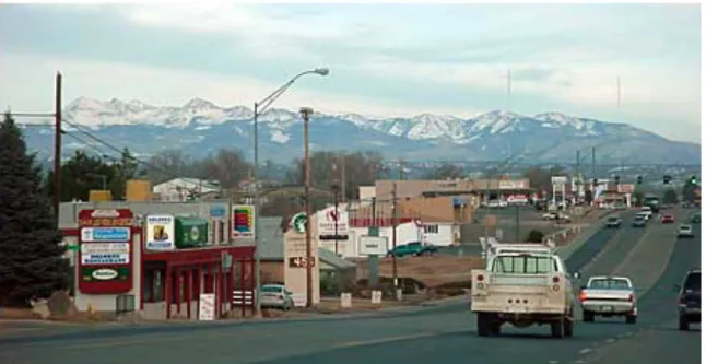
The third pilot workshop took place in October 2018 in Cortez, Colorado, the county seat of Montezuma County, with a population of 8,709 and senior water rights on the Dolores River. Montezuma County is economically dependent on agriculture, and the City of Cortez is also very dependent on tourism, particularly in relation to nearby Mesa Verde National Park (Clifford et al., 2018: 3). The Director of Public Works assisted Western Water Assessment as the community champion and helped to convene eleven other participants, including city employees, commission, and committee members, with many representing specific interests such as water treatment plants, golf courses, and parks and recreation. One interviewee mentioned that this was the most useful aspect of the process: “getting together a group of people from diverse knowledge and work roles, and being able to put together a more cohesive message to the public,” especially since Cortez’ focus has been and continues to be on water conservation-related education (Interview 16).
As in the previous two pilots, the region experiences regular droughts and experienced a severe drought in 2018 which, for example, resulted in turning off irrigation water on August 29th
compared to the norm of mid-October (p. 3). The City of Cortez has focused on water conservation efforts in the past, resulting in a decreasing per capita water demand over the past 30 years from 325 gallons per person per day in 1990 to 200 gallons per person per day in recent years (Clifford et al., 2018: 4). As WWA’s report notes, though, “This number, even if significantly lower than 30 years ago, is nevertheless still much higher than most cities across the U.S. and the rest of the world” (p. 4). Despite this long-time focus on water conservation efforts, one interviewee remarked that although “there was some awareness,” there was “not an informed concern until we started doing this planning process…VCAPS made it more tangible for everyone…” (Interview 15). Similarly, another interviewee remarked that although “drought and drought mitigation was at the forefront of our minds,” the VCAPS workshop was “a way to jumpstart things” (Interview 16). With goals of furthering these efforts and continuing to work on water conservation and water supply, this workshop focused on two drought scenarios: a 2018-type severe drought and a drought that could trigger a compact call on the Colorado River.6
The first diagramming conversation focused on reduced water supply, water treatment concerns, water conservation focused on residential use and irrigation on city properties, increasing wildfire risk, and impacts to the agricultural community (Clifford et al., 2018: 13). The second drought-related diagram focused on the outcomes and consequences of a compact call on the Colorado River. As one interviewee described, the VCAPS process drew the group into talking about specific tradeoffs for the first time, such as the example of “Should parks still be green with grass and people not be allowed to water at their houses? Is the common good more important?” (Interview 17). Actions identified in this workshop focused on many of the conservation and public education goals that participants were already committed to (but identifying new potential actions), while also exploring more direct actions (including expanded storage options, water restriction mechanisms, and landscape changes for municipal properties) (p. 28-35).
The Cortez workshop participants are notable amongst this group of pilot workshops for how closely they have kept up with the actions that they set as priorities during the workshop, and for how much they have been able to accomplish since. Workshop participants (excluding WWA
6 In 1922, the seven U.S. states in the Colorado River basin signed the Colorado River Compact, which allocated water
rights on the river based on separating the states into an Upper Division and a Lower Division, with the Upper Division required to pass along a specific flow of water to the Lower Division. A compact call would reduce water to users in the Upper Basin States if they are “unable to deliver the water they are required to send through Lake Powell [to the Lower Basin States] under the rules” of the Colorado River Compact (American Rivers, 2019). In this case, the state of Colorado is in the Upper Division and a compact call could reduce water availability from the Colorado River for users in Cortez.
team members, who do not maintain regular involvement post-workshop) have continued to meet regularly over the past eighteen months. Their first meetings included going through the report as a group and pulling together their own executive summary to make it more readable and useful for themselves. They also invited a WWA climate scientist to give the workshop presentation at a City Council meeting to share the process with a wider group of elected officials (Interview 16). From there, the group launched a broader public outreach and engagement effort called “Water is Our Future” to further their work on water conservation. They have given presentations to different groups, tabled at local events, organized educational seminars and demonstrations, partnered with local businesses and plant nurseries on different campaigns, and provided rebates for the purchase of low water consumption fixtures. The group is also using ongoing monitoring to ensure that their actions are having an impact on local water demand (Interview 16). So far, the group has invested $15,000; this represents a tripling of their intended investment after the group approached the City Council post-VCAPS to ask for greater support (WWA Interview 4). In addition, the group is working on parallel efforts to improve planning efforts through the City’s water source protection plan and an upcoming drought mitigation plan that will significantly build off the outcomes of the VCAPS process (Interview 16).
Routt County, Colorado:
Figure 9: Routt County in NW Colorado (Source: Google Maps)
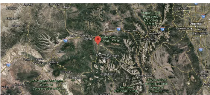
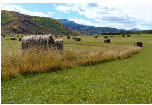
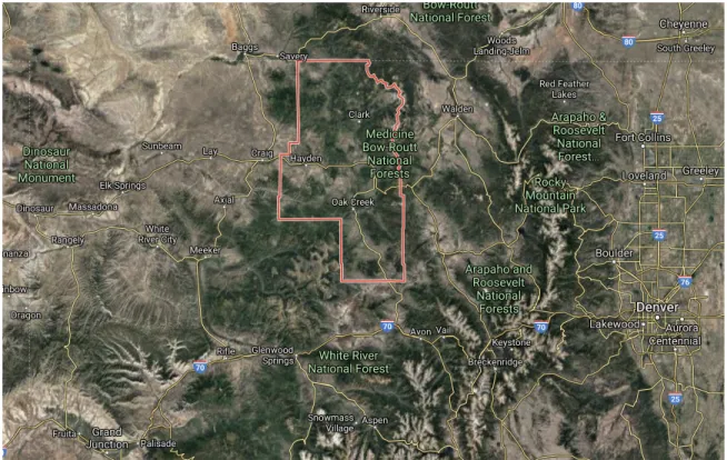
Later in October 2018, the fourth workshop took place in Routt County, Colorado, which is located west of the Colorado Rockies in the north of the state. The county has a population of 25,220, “representing an almost 87% increase over the past 30 years,” and relies primarily on agriculture (including cattle ranching and hay farming) and river-based recreation as its economic base (Rick, Duncan, Clifford, & Dilling, 2018: 4). For this workshop, the WWA team worked with the Deputy County Manager, a Colorado State University Extension agent, and the Executive Director of the Yampa Valley Sustainability Council to identify experts on agriculture as participants for the workshop. The additional eight participants (for eleven total) included one county
commissioner and one county employee, two state employees (Forest Service and Department of Natural Resources), another Colorado State University Extension agent, and three local agricultural producers/advocates. Respondents to WWA’s survey and interviewees expressed the view that this diversity of expertise was a really useful part of the process.
As in the other Colorado communities, Routt County experiences drought on a cyclical basis and experienced one of its most severe drought events in 2018. With interest in beginning to work on a drought plan at the County level, this workshop focused on two drought scenarios: a 2018-type drought and a 2018-type drought lasting multiple years. The first set of diagrams focused on four issue areas related to reduced water supply: reservoir drawdown, reduced ecological health of the
river, increased severe wildfire events, and a strong focus on reduced agricultural production (Rick, Duncan, Clifford, & Dilling, 2018: 12-3). The second set of diagrams for a multi-year drought largely focused on more extreme outcomes related to the issue areas above, as well as an additional
potential issue of water conflicts (p. 20). At the end of the workshop, participants reconfirmed their commitment to two of the workshop’s initial goals, recognizing that they would like to continue to work towards meeting them: 1) “Identify actionable strategies to support the agricultural community and mitigate risks associated with drought, in light of scientific uncertainty”; and 2) “To inform county drought response planning to include strategies that promote a vibrant agricultural community in Routt County” (p. 30).
From the survey, respondents wrote that what was useful about the process was, “The concept of shared learning and planning – getting people together with different expertise and experiences to address a common issue” and “Reasoning through possible scenarios with people who have firsthand knowledge of what might happen.” One interviewee went more into detail describing the usefulness of having different people in the room to say that it was helpful for “making headway with elected officials” and giving different water management districts the opportunity to share their various approaches (Interview 18). However, this same interviewee also raised a critical issue about the workshop, saying that the collaborative learning and relationship-building in the room did not carry beyond the workshop. This was due to some participants feeling as though they did not get a lot out of the workshop and, thus, being less willing to engage on related issues in similar forums since then. The interviewee mentioned that conveners expended a lot of social capital to get specific people in the room, but then the workshop ended up being a “net-negative on social capital” (Interview 18).
The lack of action that concerned the above survey respondent is mirrored in the outcomes described by the eight survey respondents and in conversations with the interviewees. In responding to the survey, only two participants said that new actions had been taken, with four “not sure,” and two responding “no.” Those participants who do believe there have been follow-up actions since the workshop described the following. One interviewee mentioned a continuing desire for a climate action plan at the County level but, in the meantime, they are working on redoing the County Master Plan with a broader focus on land management decisions and integrating in reflections from the workshop discussion (WWA Interview 5). A subsection of participants who were committed to moving actions forward met a couple of times following the workshop and worked to bring on an intern through the Colorado State University Extension. This intern helped these participants work
through the report, including going through action tables to “remove ‘pie-in-the-sky’ brainstorm ideas and try to narrow [them] down to more reasonable ones” and attempting to attach individuals or agencies to specific action items (WWA Interview 5). Lastly, the intern helped participants establish the Routt County Wildfire Mitigation Council, which is spearheaded by the Colorado State Forest Service. One action from this was to organize a wildfire mitigation conference in May 2019. It is key to note in this example that actions have mostly been catalyzed by specific actors, including Colorado State University Extension and the Colorado State Forest Service, but that they do not necessarily demonstrate ongoing collaboration between all participants.
Springdale, Rockville, and Hurricane, Utah:
Figure 11: From West to East: Hurricane, Rockville, and Springdale, in Southwest Utah (Source: Google Maps)
The fifth, and final official, pilot workshop took place in November 2018 and focused on three communities in Washington County, Utah along the Virgin River: Springdale, Rockville, and Hurricane. All three are gateway communities to Zion National Park, with populations of 592, 272, and 17,135, respectively (Arens, Clifford, & Rumore, 2018: 4). Working with the Director of Community Development for Springdale as the community champion, the workshop included nine other participants from the three communities, including city employees and an elected official, as well as emergency management personnel. The workshop included five participants from
Springdale, two from Rockville, two from Hurricane, and one who works between all three communities. A unique characteristic of this workshop is that many participants work together regularly through the Zion Regional Collaborative, a regional planning group, which has, among other things, introduced its members to impacts of climate change on extreme precipitation and drought (Arens, Clifford, & Rumore, 2018: 6).