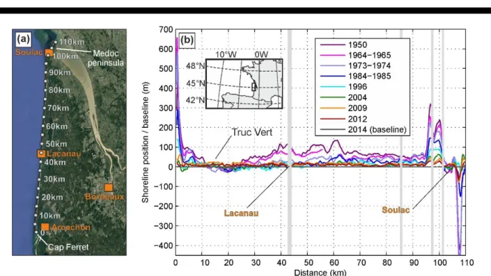
Alongshore-Variable Beach and Dune Changes on the Timescales from Days (Storms) to Decades Along the Rip-dominated Beaches of the Gironde Coast, SW France
Texte intégral
Figure
Documents relatifs
Although human activity is considered to be a major driving force affecting the distribution and dynamics of Mediterranean ecosystems, the full consequences of projected
It is in order to address this issue, which is of interest to all administrators involved in beach management and those concerned about the well-being of users, that the
a statistical analysis of the results, provide the extreme levels along the Iberian Atlantic coast 38.. for different return
This paper focuses on the entire European Atlantic coast and has three main objectives: i A proposal for the first overall chronology of storm events at the European coast
This high WEPA was linked to a recent increase in inter-annual variability, which was also observed in the winter-wave variability along western Europe (Castelle
The present study builds on recent research on atmospheric and ocean wave climate in the North East Atlantic over the last 70 years using numerical weather
Third international conference on Advances in Extreme Value Analysis and Application to Natural Hazard (EVAN), Sep 2017, Southampton, United
I n developping countries, and especially in West-african sea countries such as Senegal and Mauritania, two main trajectories could be highlighted: in one
