HAL Id: insu-01354338
https://hal-insu.archives-ouvertes.fr/insu-01354338
Submitted on 18 Aug 2016
HAL is a multi-disciplinary open access
archive for the deposit and dissemination of
sci-entific research documents, whether they are
pub-lished or not. The documents may come from
teaching and research institutions in France or
abroad, or from public or private research centers.
L’archive ouverte pluridisciplinaire HAL, est
destinée au dépôt et à la diffusion de documents
scientifiques de niveau recherche, publiés ou non,
émanant des établissements d’enseignement et de
recherche français ou étrangers, des laboratoires
publics ou privés.
Contrasting geophysical and geochemical signatures of a
volcano at the axis of the Wharton Fossil Ridge (N-E
Indian Ocean)
Hélène Hébert, Benoit Villemant, Christine Deplus, Michel Diament
To cite this version:
Hélène Hébert, Benoit Villemant, Christine Deplus, Michel Diament.
Contrasting geophysical
and geochemical signatures of a volcano at the axis of the Wharton Fossil Ridge (N-E Indian
Ocean). Geophysical Research Letters, American Geophysical Union, 1999, 26 (8), pp.1053-1056.
�10.1029/1999GL900160�. �insu-01354338�
GEOPHYSICAL RESEARCH LETTERS, VOL. 26, NO. 8, PAGES 1053-1056, APRIL 15, 1999
Contrasting geophysical and geochemical signatures of
a volcano at the axis of the Wharton fossil ridge
(N-E Indian Ocean)
H61ne H6bert, Benoit Villemant, Christine Deplus
1, Michel Diament
Institut de Physique du (]lobe, Paris, France
Abstract. The Styx volcano is a prominent seamount (20- 30 km diameter, 2500 m high) located at the axis of the Wharton fossil spreading center (N-E Indian Ocean), where seafloor spreading stopped 40 Ma ago. Gravity modeling shows that it was emplaced on a weak lithosphere, in agree- ment with an on axis origin when seafloor spreading was active. The rocks dredged at the summit of the volcano are extreme typical alkaline basalts, indicating a deep enriched
mantle source. We show here that most of this seamount
was emplaced during the final stage of the seafloor spread- ing in the Wharton Basin. We then discuss how alkaline magmatism can be emplaced at the summit of the Styx.
1. Introduction
and geodynamic setting
This paper discusses the origin of a seamount located at the axis of the fossil spreading center in the Wharton Basin (N-E Indian Ocean), through its geophysical and geochemi- cal characteristics. The seamount was discovered during the
Samudra
cruise
(R/V L'Atalante, december
1995) [Deplus et
al., 1996] and was named Styx.
Seafloor spreading stopped in the Wharton Basin (figure 1) during the kinematic reorganization which affected the
Indian Ocean at the Eocene [Patriat and $dgoufin, 1988],
followed by the initiation of seafloor spreading at the South-
east Indian Ridge. Few data [Liu et al., 1983] were available
before the Samudra cruise to precisely define the axis of the Wharton fossil spreading center. The new data collected
during this cruise [Deplus et al., 1998; Hdbert, 1998] con-
sist of multibeam bathymetry and back-scatter data, grav- ity, magnetics, 6-channel seismic, 3.5 kHz profiling, and two dredges.
Three EW segments of the Wharton fossil ridge have been identified from' the magnetic anomalies and the morphol- ogy of the basement deduced from bathymetric and seismic data. The magnetic anomalies show that the half spread-
ing rate rapidly evolved
from fast (about 6 cm/y at 50 Ma)
to slow (about 2 cm/y at 40 Ma) values, before cessation
of spreading
which is estimated at 38 Ma [Hdbert, 1998].
The bathymetric data reveal the presence of two prominent seamounts (Styx and Hellas, figure 2). Hellas is proposed
to be an inside corner high of the fossil
ridge [Hibert, 1998],
with dredged basalts having a typical MORB signature.
1Also at Centre National de la Recherche Scientifique
Copyright 1999 by the American Geophysical Union. Paper number 1999GL900160.
0094-8276/99/1999GL900160505.00
The Styx volcano (at least 2500 m high and a mean di- ameter of about 20 km) interrupts the axial valley of the
about 100 km long westernmost
axial segment (figure 2).
This valley is elsewhere 20 to 30 km wide and about 1000 to 2000 m deep. Thus the volcano height should have reached more than 3000 m above the floor of the former axial valley elsewhere covered with thick sediments (500 to 1000 m).
2. Mode of emplacement of the
seamount deduced from gravity data
2:1. Method and data
A successful method to distinguish between the possible origins of seamounts is to study the flexure of the lithosphere due to the loading of the volcano, [e.g. Watts et al., 1980;
Menard and McNutt, 1982; Watts and Ribe, 1984]. The
flexure of the lithosphere can be characterized by its equiv- alent elastic thickness (Te), which is in oceanic domain, at first order, proportional to the square root of the age of the
lithosphere
at the time of loading [Watts et al., 1980]. Since
the elastic model is only an equivalent model and since ther-
mal rejuvenation
can occur [Menard and McNutt, 1982], this
method can not be used to determine a precise age. But it can be used to determine whether the major part of the load was eraplaced on-ridge (lithosphere 0-5 Ma old) or off-ridge (lithosphere older then 10-15 Ma) [Watts and Ribe, 1984;
Goslin and Diament, 1987].
Assuming that the lithospheric flexure is parallel to the crust-mantle boundary, we determine the elastic thickness by modeling the gravity data with various Moho geometries (constrained by various Te). The free air anomaly contains
the gravity effects of the water/sediment, sediment/crust
and crust/mantle interfaces. As the lateral thermal varia- tions due to mantle upwellings beneath the axis have dis- appeared at a fossil spreading center 40 Ma old, the corre- sponding gravity effect need not be taken into account. But we must account for the preexisting axial depression. The preexisting valley is modeled with a fiat 6500 m deep bot- tom and bounded by a rectangular shape inferred from the
seismic
and magnetic data (dashed line in figure 2). The
preexisting Moho is defined as parallel to the valley, by as- suming a 6 km thick crust. All computations are made in
the spectral domain [Parker, 1972] in 3 dimensions.
We dis-
cuss results for two profiles, one along and one across the axis (location on figure 2).
2.2. Results
For both profiles (figure 3) and for any crustal density
between
2600 and 2900 kg.m
-•, the free air anomaly
is best
fit (RMS • 2 mGal) with a low equivalent elastic thickness
1054
HI'BERT ET AL.' ORIGIN OF THE STYX SEAMOUNT (N-E INDIAN OCEAN)
80øE 10 ø o .10 ø .20 ø90øE 100øE 110øE
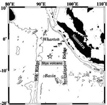
Figure 1. Sketch of the geodynamic setting of the Whar-
ton Basin,
which is bounded
by the 90E Ridge to the west
and the Sumatra trench to the east. The location of the
three westernmost segments of the fossil spreading ridge is deduced from the interpretation of magnetic anomalies iden- tified with the data of the Samudra cruise. The Styx volcano is located on the westernmost segment and is shown with the grey star.
(To < 4 km). For a crustal
density
of 2700
kg.m
-3 , the best
model is obtained for To - I km. This result suggests that the volcano was formed on-axis. Indeed to reconcile a very low rigidity with a lithosphere older than 10-20 Ma, a ther-
mal rejuvenation hypothesis seems unsuitable for the Whar- ton Basin. On the other hand, the presence of the fossil nor- mal faults bounding the axial valley might have decreased the rigidity of the lithosphere. We modeled the deflection of a faulted lithosphere in response to the topographic load of the Styx volcano, with various equivalent elastic thicknesses by using the 3D analytical method developped by Wessel
[1996]. All attempts to reproduce
a significant
flexure with
a rigidity higher than with Te - 5 km failed. It is thus un- likely that the volcano formed on a plate older than 10 Ma. In addition, basalts dredged at the summit are sometimes well vesiculated, indicating an eruption under a low water
column (that is < 1000 m). The subsidence
laws [Stein and
Stein, 1992] predict that the sea-bottom deepens
by about
2500 m after 40 Ma, corresponding to the present depth of
the summit of the volcano. Based on all these results we
suggest that the volcano was emplaced about 40 Ma ago during the final activity of the Wharton ridge.
3. Geochemical results
The dredge performed close to the summit of the Styx volcano collected large quantities of carbonate rocks and few volcanic rock fragments which consist of altered basaltic lavas. No radiometric data are available because of sample alteration, but this alteration and the presence of a thick sedimentary cover suggest that the volcano was not recently active. All volcanic products have been analysed by XRF for major elements and INAA for trace elements.
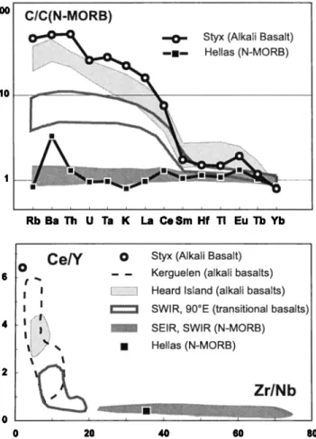
Surprisingly all volcanic fragments are typical alkali ba-
salts (SiO2 2 45%) with high Ti and alkali contents
(TiO2 _
2.4% and Na20 + K20 2 5.4%). Their composition pattern
normalized
to N-MORB (figure 4a) displays
a characteristic
enrichment in incompatible elements (50 times MORB con- centrations for Rb, Ba and Th) with no negative Ta and Ti
92 ø 00'
92 ø 20'
92 ø 40'
93 ø 00'
93 ø 20'
-5 ø 00'
-5 ø 20'
-5 ø 40'
Figure 2. Bathymetric
map compiled
from multibeam
data gathered
during the Samudra
cruise
(isobaths
150 m). The
location of the axis (squares)
and of chron 18 (C18 - 40.1 Ma, circles) are deduced
from magnetic
anomalies
along NS
tracks. Limits of the preexisting
axial valley (dashed
line) are inferred from seismic
data and magnetic anomalies. The
two profiles
modeled in figure 3 are represented
with solid black lines. The black stars indicate the approximate
locations
H•BERT ET AL.' ORIGIN OF THE STYX SEAMOUNT
(N-E INDIAN OCEAN)
1055 40 30 20 10 o -10 -20 -30 -40 West East -5 -10 -15 '. . . -20 .. :.: . .... -:: 20 40 60 80 70 60 50 '• 40 E 3O 2O 10 0 / _• •.•' N• ' 0 2 4 6 8 10( E -10 -15 -2O 140 160 180 200 220 kmFigure 3.
Crustal models for two profiles across the
Styx volcano (a and b, location on figure 2): upper mantle
(black), crust (grey) and sediments
(light grey). For both
profiles, the free air anomaly (dashed lines) is well fitted
by the model with Te = i km (solid line) and pc - 2700
kg.m
-3 . RMS values
(mGal) obtained
when varying
Te and
the crustal density pc are plotted in the insets.
anomaly. In addition, the Styx basalts display the most en-
riched character ever encountered for Indian Ocean basalts
(figure 4b). Thus the volcanic rocks dredged at the Styx seamount are produced from a pure enriched mantle source. On the contrary the volcanic samples dredged at the Hellas volcano are typical N-MORB (figure 4).
4. Discussion
The geophysical results indicate that most of the Styx volcano was emplaced on-ridge. How such an edifice can be built on the axial valley? Volcanoes as huge as the Styx seamount are not observed in the axial valleys of slow spreading ridges despite the important bathymetric cover- age available. But a few high reliefs have been observed at the ultra slow Southwest Indian Ridge, interrupting the axial valley [Patriat et al., 1997] and displaying gravity sig-
natures [Roramevaux-Jestin
et al., 1997] similar to that of
the Styx volcano. They have been interpreted as resulting
CIC(N-MORB)
••
...
•0- Styx
(Alkali
Basalt)
--1--
Hellas
(N-MORB)
:•.?,•
...
.•_,•:•_.:::...:..,.•...-:.
:•11• ..
,•: • ß i "::•:::•: ... '.i.' .... •i:i:i'5i'::""-" :"-:!%.
lOO
Rb Ba Th U Ta K La CeSm Hf Ti Eu Tb Yb
Ce/Y
o
Styx
(Alkali
Basalt)
O
- - Kerguelen (alkali basalts)
I I
Heard
Island
(alkali
basalts)
I I ....:.•.•• SWIR, 90øE (transitional basalts) .---'---'::!i:•,
I :::::::::::::::::::::::
I[}!i•:-.-•?:ii!!
•-";;.----;;-•-•:•
SEIR,
SWIR
(N-MORB)
ß
[;:•::i:•ii!!iiii;i;•-:--•
¾ ,.
ß
Hellas
(N-MORB)
Zr/Nb
....
•
i I
0 20 40 60 80
Figure 4. Trace element composition patterns .of basalts dredged in the Wharton fossil spreading center, compared to basalts from the Indian Ocean. a: Composition of basalts normalized to N-MORB. b: Ce/Y vs Zr/Nb diagram. Cir- cles: basalts from the Styx volcano exhibiting an extreme alkaline signature. Squares: basalts from the Hellas volcano showing a typical N-MORB signature (C/CN-•4OR• •1). Data sources from LeRoex et al. [1983], Class et al. [1996], Frey and Weis [1996] and references therein.
from the focusing of magmatic activity at very low spread- ing rate [Cannat et al., 1997]. Similarly, the Styx volcano could have been emplaced during the terminal activity of the Wharton Ridge, when the magmatic production decreased before stopping.
The geochemical analysis does not display any MORB component in the basalts dredged on the Styx. This implies the presence of a pure enriched mantle source (i.e. a plume) beneath the ridge. Data collected during the Samudra cruise show no evidence of any plume activity around the Styx vol- cano, thus this plume should have been of limited extent in time and space. Was this plume active during the terminal activity of the Wharton ridge, or long after? Since no dat- ing is available for the basalts dredged, we discuss the two possiblities.
In the first case, as observed for the SEIR, the 90E Ridge, the interaction between a plume and an active ridge pro- duces intermediate magma compositions (figure 4), and by no way such an extreme alkaline signature. How can we explain the lack of evidence for mixing of the sources? We may suppose that in the particular case of the Wharton
1056
HI'BERT ET AL' ORIGIN OF THE STYX SEAMOUNT
(N-E INDIAN OCEAN)
dying ridge, the upper mantle contribution was drastically reduced. It may have allowed the migration of pure alkaline basalts from the plume, without any mixing with the upper convective mantle. Basalts have been dredged close to the summit of the Styx volcano, and this does not exclude that the bottom of the Styx may contain basalts with a more
transitional character.
We can also propose a two-step emplacement for the Styx volcano. The major part of the edifice was formed during the terminal activity of the Wharton ridge. Then, additional volcanism involving a pure enriched mantle source occurred on the preexisting volcano. Such multiphased emplacements have already been proposed for qceanic features of the In-
dian Ocean and for South Pacific seamount
chains
[Diament
and Baudry, 1987; Goslin and Diament, 1987; McNutt et al.,
1997].
To conclude, we note that a large zone of the Wharton basin is covered by numerous seamounts (the emerged part of two of them are the Cocos and Christmas islands), but that the origin of this intraplate volcanism is not well un- derstood. A detailed rock sampling with radiometric mea- surements of the Styx volcano and of these other seamounts would be necessary to determine their origin and mode of emplacement, and thus would contribute to the understand- ing of intraplate volcanism and plume/ridge interactions.
Acknowledgments. We are grateful to the Captain and crew of the N/O L'Atalante during the Samudra cruise. We thank
J. S•goufin, E. Humler for useful discussion, and P. Wessel for pro-
viding its 3D modeling program. We also thank Keith Louden and
an anonymous reviewer for constructive reviews. Wayne Craw- ford kindly improved the English of the manuscript. Most of
figures were generated using GMT (Generating Mapping Tool) [Wessel and Smith, 1991], and seismic data were processed using Seismic Unix [Cohen and Stockwell, 1996]. Contribution IPGP n ø 1595.
References
Cannat M., C. Rommevaux-Jestin, D. Sauter, V. Mendel and C. Deplus, Focussed volcanism and the segmentation of the very
slow spreading Southwest Indian Ridge (SWIR) (abstract),
EOS Trans. AGU, 78, Fall Meet. Suppl., F682, 1997. Class, C., S.L. Goldstein and S.J.G. Galer, Discussion of "Tem-
poral evolution of the Kerguelen plume: geochemical evidence from 38 to 82 Ma lavas forming the Ninetyeast Ridge" by F.A. Frey and D. Weis, Contrib. Mineral. Petrol., 1œJ, 98-103, 1996.
Cohen, J.K., and J.J.W. Stockwell, CWP/SU: Seismic Unix re-
lease 28: a free package for seismic research and processing, Center for Wave Phenomena, Colorado School of Mines, 1996. Deplus, C., M. Diament, J. Dubois, H. H•bert, P. Patriat J.-J. Sibilla, G. Bertrand, S. Dominguez, J. Malod, and B. Pontoise, The Wharton Fossil Ridge: preliminary results of a 3D geo-
physical survey (abstract), EOS Trans. AGU, 77, Fall Meet.
Suppl., F960, 1996.
Deplus, C., M. Diament, H. H•bert, G. Bertrand, S. Dominguez, J. Dubois, J. Malod, P. Patriat, B. Pontoise, and J.-J. Sibilla,
Direct evidence of active deformation in the eastern Indian
Ocean plate, Geology, 26, 131-134, 1998.
Diament, M., and N. Baudry, Structural trends in the South-
ern Cook and Austral archipelagoes (South Central Pacific)
based on an analysis of SEASAT data: geodynamic implica- tions, Earth Planet. $ci. Left., 85, 427-438, 1987.
Frey, F.A., and D. Weis, Reply to the Class et al. discussion of "Temporal evolution of the Kerguelen plume: geochemical ev- idence from 38 to 82 Ma lavas forming the Ninetyeast Ridge", Contrib. Mineral. Petrol., 1œJ, 104-110, 1996.
Goslin, J., and M. Diament, Mechanical and thermal isostatic
response of the Del Cano Rise and Crozet Bank (southern In- dian Ocean) from altimetry data, Earth Planet. $ci. Left., 8J,
285-294, 1987.
H•bert, H., Etudes g•ophysiques d'une dorsale naissante (dorsale d'Aden • l'Ouest de 46øE) et d'une dorsale fossile (dorsale de Wharton) : implications sur les processus de l'accr•tion
oc•anique, et la d•formation intraplaque dans l'Oc•an Indien, ThSse de Doctorat, 372 p., Universit• Paris 7, October 1998. LeRoex A.P., H.J.B. Dick, A.J. Erlank, A.M. Reid, F.A. Frey,
and S.R. Hart, Geochemistry, mineralogy and petrogenesis of lavas erupted along the South Wes Indian Ridge between the Bouvet triple junction and 11øE, J. Petr., œJ, 267-318, 1983. Liu, C., J.R. Curray, and J.M. McDonald, New constraints on the
tectonic evolution of the eastern Indian Ocean, Earth Planet. $ci. Left., 65, 331-342, 1983.
McNutt, M.K., D.W. Caress, J. Reynolds, K.A. Jordahl, and R.A. Duncan, Failure of plume theory to explain midplate volcanism in the southern Austral islands, Nature, 389, 479-482, 1997.
Menard, H.W., and M. McNutt, Evidence for and consequences of
thermal rejuvenation, J. Geophys. Res., 87, 8570-8580, 1982. Parker, R.L., The rapid calculation of potential anomalies, Geo-
phys. J. R. Astron. $oc., 31, 447-455, 1972.
Patriat, P., and J. S•goufin, Reconstruction of the Central and Western Indian Ocean, Tectonophysics, 155, 211-234, 1988. Patriat, P., D. Sauter, M. Munschy, and L.M. Parson, A survey
of the Southwest Indian Ridge axis between Atlantis II FZ and the Indian Ocean Triple Junction: regional setting and large scale segmentation, Mar. Geophys. Res., 19, 457-480, 1997.
Rommevaux-Jestin, C., C. Deplus, and P. Patriat, Mantle
Bouguer Anomaly along a super-slow spreading ridge: com- parison with the central Mid-Atlantic Ridge and implications on the accretionary process, Mar. Geoph. Res., 19, 481-503,
1997.
Stein, C.A., and S. Stein, A model for the global variation in oceanic depth and heat flow with lithospheric age, Nature, 359, 123-129, 1992.
Watts, A.B., J.H. Bodine, and N.M. Ribe, Observations of flexure and the geological evolution of the Pacific Ocean basin, Nature, 283, 532-537, 1980.
Watts, A.B. and N.M. Ribe, On geoid heights and flexure of the lithosphere at seamounts, J. Geophys. Res., 89, 11152-11170,
1984.
Wessel, P., and W.H. Smith, Free software helps map and display data, EO$ Trans. AG U, 72, 445-446, 1991.
Wessel, P., Analytical solutions for 3-D flexural deformation of semi-infinite elastic plates, Geoph. J. Int., 1œ6, 907-918, 1996. H. H•bert, C. Deplus, M. Diament, Laboratoire de Gravim•trie
et G•odynamique, UMR 7577, IPGP, 4, place Jussieu,
75252 Paris Cedex 05, France. (e-mail: [email protected]; [email protected]. fr; [email protected] ussieu. fr)
B. Villemant, Laboratoire de G•ochimie Compar•e et
Syst•matique, UMR 7579, Universit• Paris VI et IPGP,
4, place Jussieu, 75252 Paris Cedex 05, France. (e-mail: villem ant @ipgp.j ussieu. fr)
(Received December 1, 1998; revised February 10, 1999; accepted February 23, 1999.)