January 2010, 1
Scaling the landscapes: a methodology to support integrated
sub-national spatial planning in Cambodia
Paper presented at the XXIV FIG 2010 conference: Facing the Challenges-Building the Capacity, Sydney, 11-16 April 2010, by:
NGUON Rattanak, Director,
Department of Land Management Urban Planning, Construction and Cadastre
Battambang Province
DIEPART Jean-Christophe, Senior Advisor for Spatial Planning German Development Service Battambang Province, Cambodia
Introduction
Over the last 30 years, the context of development in Cambodian has undergone dramatic changes. A succession of deep transformations, characterized by a complete restructuring of institutional and socio-economic environment, has resulted in a singular situation. Cambodian society remains largely agrarian, with land being the corner stone of the production system for a large majority of the population. To address a growing food demand of an increasing rural and urban population1, the agrarian systems are being transformed by the intensification of the livestock and cropping systems as well as by the territorial expansion onto the forest areas. The urbanization and industrialization of the economy are additionally becoming key drivers for the development of the country. All these intertwined processes are leading to dramatic land use changes within a more and more competitive environment of access to land.
Cambodia has also embarked in a comprehensive “Decentralization and De-concentration” reform process aiming at a redistribution of power and functions from central to sub-national levels. Land and natural resources management planning is amongst the new prerogatives of elected councils at province, municipal, district and commune levels. Yet, the mechanisms and responsibilities for devolved spatial planning are yet to be translated into sound procedures and practices. The paper is aimed as a contribution to fill in this vacuum.
Building on the debate about notions of scale and governance, the paper presents the institutional foundations of the spatial planning system that is being designed in Battambang province2, Cambodia3. It addresses some conceptual issues of scales to be considered in spatial planning. The overall planning approach and procedures are further discussed with specific reference on multi-stakeholders participation and spatial analysis using a combination of GIS-RS and perception-based mapping techniques. The paper reviews how the principle of countervailing influence is applied to produce a provincial spatial planning policy framework, district spatial master plans and legally-binding commune land use plans.
1
Average annual demographic increase between 1998-2008: 1.54%/year for the whole country (2.21%/year in urban areas and 1.38% for rural areas), (NIS, 2009)
2
Battambang province: 11.929 km2 and 1.025.174 inhabitants, NIS 2009.
3
The initiative, the first of its kind in Cambodia, is supported by different German cooperation agencies with central intervention from the German Development Service (DED). The Konrad Adenauer Foundation (KAS), Capacity Building International (In-Went) and the German Technical Cooperation (GTZ) are also supporting the process. In Battambang province, the particular role of the DED is to provide integrated land use planning support at various levels (province-district and commune), see Symann, R., 2008.
January 2010, 2
1. Spatial planning emerges in the Cambodian governance landscape
In Cambodia, spatial planning is becoming increasingly recognized as a prerequisite for sustainable development but is still very much under construction. Its emergence takes place in a somewhat challenging and quickly evolving institutional environment.
1.1 Decentralization and De-concentration reform process
The Decentralization and De-concentration4 (D&D) strategic framework, which is now embedded in a recently approved organic law5, sets out the vision and basic principles for deep governance reform in Cambodia. The D&D reform aims to replace the management structure and systems of public institutions and to develop new management systems that rest on principles such as democratic representation, participation of people (in consultation and/or in decision making), public sector accountability and effectiveness. By promoting these principles, the vision is to achieve broad-based and sustainable development and to strengthen vibrant local economic foundations so every citizen has an equal opportunity to participate in local development, effective natural resources management and delivery of quality public services.
The first commune council election in 2002 has established a new local government structure across the country and has raised new opportunities for people to participate in and play a more active role in decision-making processes at local level. This represents the beginning of a fundamental change in governance. New accountability links are established between local authorities and local population. In a society traditionally structured from the top down, it also requires a shift in how people think about governance.
The management system that is being progressively replaced at the sub-national level6 consists of the State departments or agencies, which are vertical lines from the national level. These government line agencies execute policies and plans of the line ministries at the national level. They are supposed to be coordinated, promoted and guided by the sub-national government but, in reality, they perform their duties directly and are responsible to their line ministries (Ayers, 2005).
Addressing this weak horizontal integration, the D&D reform envisions the creation of a unified administrations management system (at provincial or district level) and empowers these administrations to prepare, adopt, approve and implement 5-years strategic development plans and yearly investment plan to actualize the strategic development plan (Horng and Craig, 2008). For the first time in 2009, provincial and district councils were indirectly elected by all commune councilors7 to endorse the new responsibility and authority system. A unified budget is to be transferred from line ministries to the unified administrations to endorse responsibilities and implementation of development projects. Amongst other things, the strategic development plans shall contain a development framework which describes the basic principles for the use and management of land and natural resources in that area. Spatial planning emerges as a new prerogative of sub-national government
4
Decentralization is a politic process whereby an additional level of democratically elected government is formed (commune councils) to give ordinary people greater opportunities to determine their future (Ayers 2005). De-concentration is an administrative process that aims to improve the performance of national functions by bringing those functions and the appointed national civil services closer to the people that they are designated to be served. Both of these definitions are extracted from Pellini, 2004.
5
Law on Administration and Management of the Capital, Province, Municipality, District and Khan, passed on April 1st 2008
6
In Cambodia, territorial administrations are structured downward in province, district, commune and village.
7
January 2010, 3
1.2 Cambodian land law and land policy framework
Another institutional pillar lies with the Ministry of Land Management, Urban Planning and Construction. Released in 2001, the Cambodian land law has marked a pivotal point in creating a legal platform for improved land management. Nevertheless, a land law is no substitute for a comprehensive land policy to fix the direction and rules needed for implementation. The Cambodia land policy is still in a drafting process8 but an Interim Paper on Strategy of Land Policy Framework already gives some guidelines for land management and land use planning9. This document highlights quite clearly the need for effective land management planning in Cambodia. It argues that the lack of integrated land use plans and natural resources management result in many problems including the encroachment onto protected areas, the construction of inappropriate sites, illegal logging, confusion about jurisdiction, land grabbing and cancellation of rights to subsistence use of natural resources. It adds that this problem impacts the sustainable exploitation of forests and fisheries and the economical use of water. This affects the livelihoods of the poor, as well as tourism and the growth of cities10.
The interim paper proposes, in accordance with the overall governance policy of promoting decentralization and de-concentration, to redistribute land management and administration tasks to province and district (and commune whenever appropriate). It foresees that these various sub-national government institutions developed an interlocking set of land use plans that defines at different levels (i.e. national, provincial, district and communal) the rules and principles for sound land management. When spatial planning started few years ago in Cambodia, the situation facing the planners was somewhat challenging. Spatial planning had been initiated on a pilot basis with village participatory land use planning and commune land use planning approaches11. Commune land use planning is now embedded in the legal framework of Cambodia12 and is a legal reference for spatial planners.
In essence, these approaches are participatory and aim to produce local-level land use plans which are endorsed by elected commune councils. The plans are integrated into the local development planning process initiated within the framework of the Decentralization reform since 2002. Local land use dynamic were apprehended under community-based natural resources management (CBNRM). Emphasis has been placed on the support of local communities, on strengthening local governance, promoting local decision-making, and facilitating the implementation of locally designed natural resource management plans. But despite a clearer commitment to justice for rural people, this mainstream approach toward spatial planning primarily focused on local management has not been able to support rural development in a fully satisfactory way which has failed to integrate local issues in a wider context of regional development in which natural resources is apprehended in a balanced way with the agricultural development, the demographic change, the industrialization and the increasing role of markets and State.
Indeed, spatial planning at meso level (province or district) is at its infancy and no real spatial plan had ever been released or designed at those levels. Thus far, planning environment at district or provincial level was characterized by a lack of participation and consultation with population. The horizontal integration of government agencies was rather weak as the budget mainly flows in direct vertical lines form the ministry to these agencies. Development efforts were fragmented by sector and surprisingly, there were little attention by donor community for improved coordination. But the institutional re-engineering of the D&D reform brings new promises. The vision to devolve both responsibilities and authorities to sub-national councils is likely to generate stronger integration between agencies and an
8
Müller, F.V. (2008). “Land policy development in Cambodia: status, process and challenges” GTZ land management and allocations projects (internal discussion).
9
Interim Paper on Strategy of Land Policy Framework, Council of Land Policy, 2002
10
ibid
11
Village Participatory land use plan has been substituted for commune land use planning to better fit into the
decentralization development and investment planning processes initiated after the first commune council election in 2002.
12
January 2010, 4 opportunity to go “beyond the sector”. Comprehensive and cross-sector spatial planning may benefit from this change in the governance structure.
Nevertheless, the distribution of functions and powers from central to sub-national level in land management is somehow going very fast and the national level has not yet managed to establish a clear national spatial planning legal and policy framework. Except for the sub-decree on commune land use planning, there is no clear legal and policy foundation for the development of the interlocking and coherent set of land use plans (i.e. a sub-decree that specifies the roles and responsibilities of each agency involved and the type of planning documents that need to be produced). The development of a national spatial planning policy is especially important as Cambodia has signed a number of bi- or multilateral agreements with other countries members of the association of south-east Asian countries (ASEAN) and is a member of world trade organization (WTO) since 2004.
1.3 Spatial planning infrastructure
The absence of a national spatial planning policy is also reflected in an unclear spatial planning infrastructure. The lack of geo-spatial data or the difficult access to it limits considerably the development of spatial planning. The overlay of geo-data in a computer is a core element of the geographic information system and is routinely carried out by planners. But the access to such manipulation is not obvious. In addition to obvious financial constraints that spatial planners face to acquire updated data (esp. recent land use/land cover data), there are also significant institutional barriers to be overcome before the data can be accessed. These barriers deal mainly with a resistance for sharing information, as release of data is usually perceived as a loss of power.
On the other hand, there are pressing needs for capacity development and the constitution of a pool of national resources persons for spatial planning. The capacity development doesn’t concern only the transfer of knowledge to carry out technical mapping operations but also on concepts and facilitations skills that people need to acquire to work effectively at the intersection of a number of technical fields.
2. Building the methodology
2.1 The scales at stake: some conceptual issues
Land management and spatial planning in particular deal with land systems in which the interactions between the ecosystem (the environmental processes) and the human rules (the social processes) for the use of that system can be very complex. This complexity means that it is hard to design foolproof and sensible rules to govern these systems (Wilson et al., 1999). The scale at which those environmental and social processes are being addressed is then a critical point of analytical reference. Scale, defined as a mental construct that helps to make sense of reality, tends to assimilate the concept to a numeric ratio and reduce the debate on the unit of analysis and the resolution. By doing so, one misses the point of understanding what determines the scale. Instead, we rather apprehend scale as a product that result from the interaction between social and environmental processes at different levels. Given the different scales through which social and environmental processes occur, the understanding of society-environment relations can be improved by analyzing varying scalar configuration of those interactions (Engel-Di Mauro, 2009). Reconciling the diverse approaches to scale is at the center of the spatial planning work. The interactions between social and environment processes are to be understood at different levels and then addressed by decision-makers in a governance framework, at a given scale that adequately matches these processes.
The interactions between social and ecological processes are multiple and can be addressed from a local context to a global perspective. Working on sub-national spatial planning, micro and meso levels of analysis are pivotal in understanding people-environment relations, especially given that the most tangible occur largely over small areas (Engel Di Mauro, 2009). A context-situated approach offers greater sensitivity with respect to identifying agro-ecological and socio-political specificities of an
January 2010, 5 area and to grasping how the land use drivers are actually working out. The development of political ecology (see for instance Springate-Baginski & Blaikie, 2007), has greatly contributed in the last decade to improve our understanding on in interplay between societies, power and land resources.
But this focus of small-area dynamics can result in difficulties to integrate patterns of development into larger societal and environmental processes. Emphasis on small area can then become a hindrance when it is the sole empirical foundation of a spatial plan. References to world-systems appear then as promising and complementary perspectives to micro-meso approaches. The analytical framework of world systems is a set of mechanisms which redistributes resources from a periphery, being rural base areas typically raw materials-exporting, to the core being the industrialized poles located inside but mainly outside the country; the market being the means by which the core exploits the periphery. In South East Asia, a reference to world-systems can improve our understanding about the development of markets (agro-industrial markets in particular) and the State-driven territorialization through which most modern states divide their territories into complex and overlapping political and economic zones, rearrange people and resources within these units, and create regulations delineating how and by whom these areas can be used (Li, 2002 and De Koninck, 2006).
In these regards, the integration of Cambodia in the ASEAN development macro-corridors, the cross-border economic cooperation agreement signed with Thailand in 2001 and the arrival of Cambodia in World Trade Organization in 2004 have become critical reference to comprehend the dynamic of land use and the intervention of global actors [mainly non Cambodian] on the Cambodian territory.
2.2 The overall approach: from people perceptions to ad hoc plans
In essence, the spatial planning approach we promote is centered on the people and their communities because we consider family farming as the main driver for development. The people perceptions and knowledge, as first-hand input in the planning process, serves as a basis to actualize land use information and comprehend the dynamics of land use and land tenure change. Starting from people perception allow for identifying the socio-economic diversity in the land-labor allocation strategies and the different modalities by which rural household can play a key role in land and natural resources management (Diepart, 2010). We consider this as a condition to avoid the contradiction between environment heterogeneity and the homogeneity of a planning scheme.
The aggregation of people’s perceptions from different areas is then coupled with information provided by local decision-makers and secondary data with the aim of understanding the different scalar configuration of interaction between environmental and social processes. This enables matching the scale of land issues with the scale where the corresponding planning rules should be best addressed.
2.3 The principle of countervailing influence at play
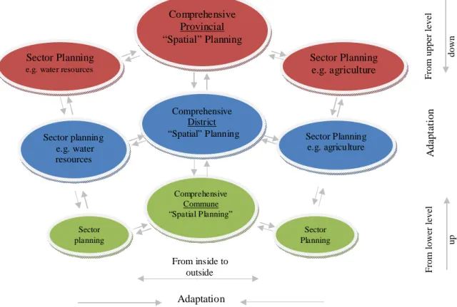
Comprehensive spatial planning, which is by nature a cross-sector and cross-level exercise, requires a permanent dialogue between various agencies located at various levels in the governance structure. We articulate this dialogue along two axis of integration (figure 1).
A horizontal integration implies, for one given level, the adaptation of sector plans into the comprehensive and cross-sector spatial plan. At the provincial level for instance, the spatial planning process requires the integration of the different sector plans from the respective agencies working at the provincial level. This integration is necessary in order to match the contents of each sector plans with the content of the comprehensive spatial plan. The comprehensive spatial plan, once approved by the different sector agencies, serves in turn as a binding reference for each sector agency to design or update its own plan. In Cambodia, this two-sided integration is coordinated by an elected council at provincial, district and commune levels.
The vertical integration involves a similar bi-directional dialogue. A comprehensive spatial plan at one given level is designed with close consultation of with coordinating lower-tiers councils. The approval
January 2010, 6 of a comprehensive spatial plan by these lower councils is essential to ensure consistency across levels and to maximize success of realization. Once a comprehensive spatial plan is approved, it serves in turn as a binding reference to lower-tiers council in the design or the update of their spatial plans.
Figure 1. The principle of countervailing influences applied in the planning process, adapted from Magel, 2008
These principles of countervailing influences are addressed horizontally and vertically all along the planning process. In a context like in contemporary Cambodia where there is no real spatial plans existing, our approach was to start from the provincial level and going downward to commune level. A provincial spatial plan is being designed by a multi-sector working group consisting of representatives of the main line agencies. The working group works under the steering and coordination of the provincial council but in close consultation with line government agencies working at the provincial level (horizontal integration) as well as with district and communes councils (vertical integration). The provincial spatial plan, once having a full support of lowers-tiers district and commune councils, serves as a reference for the design of district spatial. In the same logic, once the district spatial plan receives the support of line agencies involved at district level and from all commune councils within its jurisdiction, it serves as a reference for the design of the commune spatial plan. It should be clearly emphasized that proceeding this way from top to down (from provincial to commune spatial plans) is in no way contradictory with a participatory planning approach.
2.4 Planning procedure: consultation and participation as corner stones
A great deal of attention is brought to analyzing the specificity of local contexts, the diversity of rural production systems and the planning instruments already in place. Participation and consultation in the planning process are critical and decisive in order to ensure that a broad level of acceptance and ownership is achieved. Participation and consultation are addressed at three levels.
Particular attention was given to rural community voices. In depth surveys were conducted at village and household level in order to capture the functioning of rural communities in different agro-ecological contexts. The contribution or responses of households is evaluated in terms of local knowledge and socio-economic rationality. The lessons learned from their consultation are an
From upper leve
l
down
From lower leve
l up Comprehensive Provincial “Spatial” Planning Sector Planning e.g. agriculture Sector Planning
e.g. water resources
Comprehensive District
“Spatial” Planning Sector Planning e.g. agriculture Sector planning e.g. water resources Comprehensive Commune “Spatial Planning” Sector Planning Sector planning A d a p ta tio n From inside to outside Adaptation
January 2010, 7 incremental part in the design of the spatial planning systems. The government line agencies are also consulted at provincial and district level. Though D&D reform aims to establish unified administration, it will not wipe out the top-down hierarchical links within ministries. As a matter of fact, strategic response activities assigned to each department to tackle land issues need to be in line with the overall strategy of their line ministry. Vertical integration and coherence is compulsory so that technical departments can be involved institutionally and financially in following up the recommendations of the spatial planning system. Local authorities at district and commune level have a mandate to coordinate the development efforts made on their territory. They have to negotiate and find the balance between conflicting and/or competing interests. They also have a role in linking the planning process with private actors whose actions are usually decisive. They definitively need to be consulted. Of particular importance is the need to adjust the provincial spatial planning framework with the commune development plans updated every year. This mutual learning process is also an opportunity to consult civil society organizations that are too often not embedded in the existing planning process.
In all levels, the spatial planning process follows quite a similar sequence of activities and procedures sketched in figure 2. The sequence is not rigid and allows for some adaptation according to specific context that the planners have come across.
A relevant compilation of spatial information, figures and facts about land management serves as a basis for planning. This information forms the main base knowledge for the analysis and is derived mainly during the consultation forum organized at province; district and commune levels with participation of variety of actors. These forums allows for an update of land management information and for more dynamic analysis on the cause and consequence of recent land use change. They also offer an opportunity to address and solve existing or latent land conflicts. Future demographic and socio-economic growth scenarios are conceived to make decision-making more robust and to identify strategies for pre-empting undesirable future developments.
The stakeholders involved in the planning process are then invited to define a vision for the future development of their region. The vision is a bold development statement that depicts a future ideal state of affairs. It represents something towards which the communities are striving for. Future development strategies further specify how to reach the desire vision. They consist of specific objectives and the necessary means to reach them. Because they chart out ways in which limited resources can best be allocated to development, the strategies focus purposively on attainable targets within a range of accessible resources.
Once defined, the strategic objectives are translated by the stakeholders into a future spatial structure and a land use zoning. The future spatial structure defines the relationship between urban centers and the overall future balance between open spaces (forest and agricultural land) and built-up areas. Land use zoning is a detailed mapping of different land areas where specific regulations must be enforced. These regulations are legally binding to all citizens.
After the public display and approval of the plan by relevant authorities, the realization of the plan must be monitored and controlled. The spatial plan is evaluated by assessing the degree to which the development and investment plans are consistent with its provisions.
Figure 2. Sketch of the planning process (steps and procedure)
6. Monitoring & evaluation 5. Define future spatial
structure and land use 4. Design future development strategies 3. Visioning the future 1. Situation analysis
2. Define future demographic and
January 2010, 8 2.5 Bridging people perceptions about “their land” and the need of spatial data “at scale”
A key constraint of the planning process is mapping and the constitution of a comprehensive, consistent, reliable and trustable database. The challenge is twofold. It is crucial to generate geo-spatial information with clear referencing and scale to enable geo-spatial analysis and mark territories but, at the same time, the geo-database must reflect how people see their land and the issues they judge important. An original method combining of geographic information system (GIS) – remote sensing and perception-based mapping techniques has been elaborated to meet both ends.
The participatory spatial planning process started in 2007 by the provincial spatial plan. A number of spatial planning forum were organized in each district with participation of a panel of selected stakeholders representing the government line agencies, territorial authorities and civil society. Nevertheless, the only quality set of digital geo-information with high resolution available for the whole country is a 2002 set of layers that had been produced by the Japanese international cooperation agency (JICA) in a cooperation effort with the Cambodian ministry of public works and transport. As the planning process started in 2006 and given the magnitude of land use changes, the land use map produced with the 2002 land use data set were clearly outdated! This constraint became an opportunity to actualize land use information with the stakeholders during the spatial planning forums.
A question guideline and an A0-size 2002 land use map (at scale) had been designed prior to the forum in order to structure the discussion. During the discussion, all land use data are updated and mapped by hand using a tracing paper overlaid on the A0-size map (figure 3). Then, a discussion arises on the influential driving forces that have contributed to shaping the land to the situation existing today. The different driving forces are discussed and weighted to foresee the likelihood, magnitude and location of their occurrence in the future. Back at the office, the maps produced by the participants are reproduced, scanned, geo-referenced and utilized to produce a computerized geo-data base (figure 3).
January 2010, 9 At the end of the forum in each district, the participants were asked to divide the district territory into homogeneous unit, that are zone where social and environmental processes are translated into homogeneous system of land use and knowledge (Saqalli et al, 2009). Only the participants defined the criteria for spatial differentiation. The nature of the criteria is noted as well as the discussion and reaction between participants. The final boundaries of these zones are then discussed and agreed upon in a plenary discussion that closes the forum. By combining the land use unit mapping for all 14 districts aggregation of this exercise in all 14 districts of the province, an overall provincial land use zoning is produced (figure 4). In order to fit real land marks specified by the participants during the discussion (water bodies, road, hills…), the boundaries of each and every zone are then adjusted by using a 2008 Landsat image (7 ETM+). It should be emphasized that the satellite image supports the participatory process rather than guiding it. For each land use units a number of factual questions are asked to capture the central land management issues and develop synthetic diagram illustrating the interlinked chain of challenges and influencing factors has been created (see annex). This helps identifying the most suitable development strategy and set of regulations attached to them.
Figure 4. Result of the land use zoning in homogeneous land sue units
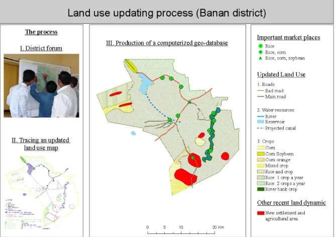
The mapping methods deployed during the district spatial planning process were quite similar, though more detailed (figure 5). Spatial Planning forums are organized in each commune with a panel of stakeholders. They offer an opportunity to update land use information following a similar sequence of activities. The forum starts by asking the participants, clustered by village, to draw detailed sketch map of their village as they see it, indicating main transport networks, water ways and land use unitsc. This information is then reproduced on a tracing paper overlaying an A0-size land use map from 2002 used as the referenced. The different driving forces are discussed and weighted to foresee the likelihood, magnitude and location of their occurrence in the future. Back at the office, the maps produced by the participants are reproducede, scanned, geo-referenced and further developed into a computerized geo-data base. The criteria to define land use categories are here also defined by the participants and adjusted to land marks by using an updated SPOT 5 imagery (10 m. resolution)f before producing an updated land use mapg.
January 2010, 10 The combination of perception-based mapping techniques with remote sensing and geographic information system is not panacea but, in the context of Cambodia, it offers a good option for participatory mapping. It presents the advantage to produce output (geographic information), which have a high semantic and topological value as well as good resolution via the use of remote senses imageries.
Figure 5. Combination of perception and remote-sensing-based mapping processes
3. The outline of a future integrated spatial planning system
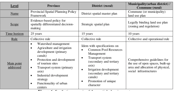
To match the sub-national administrative hierarchy in Cambodia, three levels of spatial plans are eventually elaborated at provincial, district and commune levels. These three levels of rules are envisioned to cumulatively affect the actions taken and the outcomes in managing land and its resources (figure 6).
Provincial spatial planning policy framework
The provincial level spatial plan, namely the provincial spatial planning policy framework, reflects collective choice rules. It provides provincial authorities with an evidence-based policy for spatially differentiated decision-making as well as a reference document for detailed planning and investments. It provides a birds-eye perspective on land-related challenges (i.e. constraints and potentials) that exist in the province and on how these challenges should be addressed in order to improve the land sector within a time perspective of 20-25 years.
It is a strategic policy document in essence. It deals more with aspects of scale related to the integration of the province within macro socio-economic systems (world-systems) such as the ASEAN development macro-corridors. Typically, it addresses the dynamics of deforestation and cross-border environmental change occurring in the region via agricultural intensification and agricultural land expansion into the forested uplands. Planning measures for watershed stabilization are taken at this level. The functioning of the primary-level transport system (roads, water, rail and air) is also addressed at this level as the province is part of larger ensemble, sometimes sharing more resources with the neighboring country than with its own capital. The overall structure of the road network is determinant to affirm the position of the province in a larger regional ensemble. In line with the transport system, two additional planning measures are foreseen: i) the classification of and the
c d
January 2010, 11 hierarchical relationships between the urban centers and ii) the strategies for energetic supply and industrialization.
As such, the provincial spatial planning framework is no substitute for more detailed spatial and land use planning at district and commune level. These need to be addressed at a larger scale and require complementary planning procedures and documents.
District spatial master plan
The district level spatial plan, called the district spatial master plan, also reflects collective choices. It includes a set of principles and directions that the authorities have agreed to follow for improved land management. The district master plan is not a replica of the provincial spatial planning framework though. It provides a more detailed view than the provisions included in the provincial framework (transport system and irrigation), deals with aspects of scale related to the dynamic of settlement extension and the provision and access to social infrastructures. It specifically addresses the promotion of the unique character of the region.
Commune land use plan
Whereas provincial and district level spatial plans reflects collective or policy rule for decision making, the commune land use plan reflects a set of operational rules that affect the way land is actually utilized (Ostrom, 1990).
It is a legally-binding spatial plan that comprehensively translates in a land use zoning the provisions of the provincial and district spatial plan. It is a document approved by provincial authorities and endorsed by the commune and the line administration agencies for enforcement. At the municipal level (higher-level urban center), because the challenges the area size of the planning area is rather small and densely populated, the spatial planning consist of an integration between the district master planning process with a legally-binding land use zoning approach (Battambang Municpality Master plan, 2009).
Level Province District (rural) Municipality(urban district) /
Commune (rural)
Name Provincial Spatial Planning Policy
Framework District spatial master plan
Commune (or municipality) land use plan
Scope
Evidence-based policy for spatially differentiated decision-making
Strategic spatial plan Legally binding land use plan (zoning and regulation)
Time horizon 25 years 15 years 10 years
Rule Collective rule Collective rule Collective and operational rule
Main point addressed
• Watershed management • Agriculture and irrigation
development (primary canals)
• Protection and development of tourism sites
• Transport system (primary axis)
• Industrial development strategy
• Functionality of urban centers
Idem with specifications on • Common Pool Resources
Management • Transport system
(secondary and tertiary axis)
• Irrigation development (secondary and tertiary canals)
• Promotion of unique character
Comprehensive guidelines for the use of open spaces, built-up area and allocation of physical, social infrastructures
January 2010, 12
4. Conclusion: towards spatially enabled sub-national governments
The implementation of the spatial planning documents remains an open question, asked in a positive tone. Even though the process has until now run quite smoothly, it would be presumptuous to conclude, at this stage, anything about the outputs. All the work is still very much under construction. Some concluding remarks can be made on the conditions that need to be met to put the plan into effective practice.
A cornerstone of the planning process has been participation. The successes of the implementation of the spatial plans will intrinsically depend on how the people consulted during the planning process will benefit from it.
As a result of proper planning and a more transparent basis for decision-making, rural resources are supposed to be more efficiently used and the rural livelihoods are supposed to improve. Consultation with rural communities, which the spatial framework is aiming at, will be crucial to assess and measure success.
The way that technical line agencies will integrate the decentralization and de-concentration reform remains largely unknown. This will influence the extent to which they will be willing to join forces in a unified administration, in addition to their line ministries. In the end, the use of spatial plans as reference documents will very much depend on it.
Bibliography
Ayres, D. (2005). Decentralization and Deconcentration Strategic Framework. Internal RDP discussion paper, Phnom Penh, 34 p.
Council for Land Policy (2005). Declaration of the Royal Government of Cambodia on the Land Policy. MLMUPC, Phnom Penh, 5 p.
Council for Land Policy, RGC (2002). Interim Paper on Strategy of Land Policy Framework, MLMUPC, Phnom Penh, 40 p.
De Koninck (2006). On the Geopolitics of Land Colonization: Order and Disorder on the Frontiers of Vietnam and Indonesia, in Dufumier, M., Ed., The Agriculture in Southeast Asia: An Update, Special Issue No 9-10, Moussons, Social Sciences Research on Southeast Asia, CNRS-University of Aix-en-Provence, Paris-Aix, Edisud, pp. 33 – 60.
Diepart J.-C. (2010). Cambodian peasant's rationality and participation in rural development: a perspective from Kampong Thom Province, Biotechnology, Agronomy, Society and Environment, (accepted and forth coming), 25 p.
Dupuis, D. (2008). Evolution récente des régimes fonciers et stratégies de production paysannes. Le Cas de la Province de Battambang, Cambodge. MSc Thesis (in French). Gembloux Agricultural University, Belgium. 168 p. + annexes
Engel-Di Mauro , S. (2009). Seeing the local in the global: Political ecologies, world-systems, and the question of scale, Geoforum, Issue 40, pp. 116–125.
Horng, V. and Craig, D. (2008). Accountability and Planning in Decentralised Cambodia. CDRI Working paper Series No. 39, Phnom Penh, 133 p.
January 2010, 13 Li, T. (2002). Engaging Simplifications: Community-Based Resource Management, Market Processes and State Agendas in Upland Southeast Asia, World Development, Vol. 30, No. 2, London, pp.265– 283.
Magel, H. (2008). Proposals on Spatial Planning Policy in Cambodia. Technishe Universitat of Munchen, Phnom Penh, power-point presentation, 56 p.
Master Plan Team Battambang District, (2008). Technical Report on The Draft Land-Use Plan for Battambang District, Battambang District Administration, Battambang, 188 p.
Müller, F.V. (2008). Land policy development in Cambodia: Status, process and challenges. GTZ land management and allocations projects, internal discussion paper.
National Institute of Statistics (2009). General Population Census of Cambodia 2008. National Report on Final census report. Ministry of Planning, Phnom Penh, 291 p.
Ostrom E. (1990). Governing the Commons, the Evolution of Institutions for Collective Action, Cambridge, Cambridge University Press, 280 p.
Pellini, A. (2004). Decentralization policy in Cambodia: the main actors. DED Cambodia – PRDR Kampong Thom, Kampong Thom, 16 p.
Saqalli, M., Caron, P., Defourny, P and Issaka, A. (2009). PBRM (perception-based regional mapping): A spatial method to support regional development initiative. Applied Geography, Issue 29, pp. 358-370
Springate-Baginski, O. and P. Blaikie (eds.) (2007). Forest, people & power. The political ecology of reform in South Asia. The Earthscan Forestry Library, London, 394 p.
Symann, R. (2008). Capacity Building in der lokalen Verwaltung am Beispiel Battambang, Kambodscha, DED Newsletter, Bonn
Wilson, J., Low, B., Costanza, R. and E. Ostrom (1999). Scale misperceptions and the spatial dynamics of a social–ecological system. Ecological Economics, Issue 31, pp. 243–257
Annex: Deforestation in Battambang (land use unit 1)
The most striking feature of recent land use change in Battambang is the dramatic decrease of forest cover. In a little over 15 years, forest cover has decreased from 65.8% to 44.4% of the total provincial territory. The clearance has been particularly dramatic in the north-western uplands of the province where virtually all the forest resources have disappeared.
An interaction of a number of elements is responsible for the phenomenon (figure here under). Following the peace agreement in the late 1990s, new district administration centers were created in the north-western part of the province (Kamreang, Phnom Preuk and Sampuev Lun districts). Attracted by relatively cheap land prices (if compared with other provinces) and good soil conditions, a considerable number of families started to migrate from all across the country to permanently settle in the area and start new farming activities in the uplands (non-rice agriculture such as cassava, red corn or soybean…). While the annual demographic increase between 1998 and 2007 was 2.8% on average for Battambang province, the values reached 19.01%, 17.87% and 5.89% for Kamreang, Phnom Preuk and Sampeuv Lun district respectively (calculation based on Commune Data Base, DoP, 2008). The singular values of demographic increase observed in those districts are clearly the result of permanent migration. This sharp demographic increase has triggered the demand for both settlement and agricultural lands.
January 2010, 14 In conjunction with this, the Royal Government of Cambodia and its Ministry of Agriculture, Forestry and Fisheries (MAFF) have started to promote the production of annual and perennial cash crops (mainly red corn, cassava, green gram, sugar cane and rubber) for export. This policy has enabled national and international investors to establish agro-industries involved in the purchase, storage and processing of these crops. As illustrated by the figure here under, the development of intensive upland agriculture still largely relies on human labor; the quick growth in the agricultural sector has in turn reinforced migration to those areas. The whole dynamic of settlement expansion and the development of chamcar agriculture have contributed to the decline of forest cover.
Although agricultural development dynamics have enabled a considerable number of households to increase their income (farming incomes are the highest in these uplands), the decrease of forest cover has had prejudicial consequences for local communities. Deforestation threatens the conservation of biodiversity (fauna and flora) which affect the diversity of forest products that rural families can access. Deforestation has also a direct economic impact on those families who depend on forest resources as a safety net for their livelihood. According to data from the Cambodian Socio-Economic Survey 2004 computed for the whole province of Battambang , the livelihood of the poorest rural households depend more on common pool resources (principally forest resources) than others. On the other hand, deforestation is putting the sustainability of agricultural development at risk because of the impacts it has on the overall watershed. Deforestation decreases the ground water content which inevitably impacts the nutrient and water intake of crops. It also increases the frequency of flood and drought events as well as erosion risks. Additionally, the loss of forest decreases the opportunity of economic development through eco-tourism (especially along the rivers’ banks), one key asset for the socio-economic development in Battambang.
Schematization of land use change dynamics in Battambang (1993–2008) in Land use unit 1: agro-industrial area.
The figure provides an explanatory framework of deforestation which is identified in the center of the figure (Ä Forest Cover). It differentiates between the causes and consequences of deforestation, respectively on the left and right side of that central box.
Development of cash crop agriculture Ä Forest Cover
-Creation of new administration centers ÃDemographic Growth Natural increase of the population à Permanent MigrationRGC Policy to promote cash crop production for local processing and export New settlements
land
Good soil condition
Wate rshed impacts à Frequency of flood and drought Disturbance of micro-climate à Soil erosion
Ä Ground water table Ä Bio-diversity
Ä Opportunity for eco-tourism Ä Livelihood value for Households
Agro- industrial investment