Burkina Faso
A dissertation presented to the
Faculty of Science of the University of Neuchâtel
by
Anja Maria Bretzler
to attain the degree of
Doctor of Sciences
Advisory Committee
Prof. Dr. Mario Schirmer (Thesis director)
Prof. Dr. Philip Brunner (Co-examiner)
Dr. Stephan J. Hug (Co-examiner)
Prof. Dr. Jörg Matschullat (External examiner)
Defended:
20
thof February 2018
Imprimatur pour thèse de doctorat www.unine.ch/sciences 2000 Neuchâtel – Suisse Tél : + 41 (0)32 718 21 00 E-mail : secretariat.sciences@unine.ch
IMPRIMATUR POUR THESE DE DOCTORAT
La Faculté des sciences de l'Université de Neuchâtel
autorise l'impression de la présente thèse soutenue par
Madame Anja Maria BRETZLER
Titre:
“Geogenic arsenic in groundwater of
Burkina Faso”
sur le rapport des membres du jury composé comme suit:
• Prof. Mario Schirmer, directeur de thèse, Université de Neuchâtel, Suisse • Prof. Philip Brunner, Université de Neuchâtel, Suisse
• Prof. Jörg Matschullat, TU Bergakademie Freiberg, Allemagne • Dr. Stephan Hug, Eawag, Dübendorf, Suisse
In memory of
Annette Johnson
1958 – 2015
Summary
In the semi-arid West African Sahel belt, rural populations often rely on groundwater from fractured aquifer systems for their drinking water needs. Recent evidence has shown that some tube wells in northern Burkina Faso are affected by arsenic (As) concentrations above the World Health Organisation’s (WHO) 10 µg/L guideline value. Arsenic is hypothesised to stem from geogenic (naturally occurring) sources, specifically sulphide minerals occurring in ore zones. Arsenic is a potent carcinogen and long-term exposure even to low concentrations can lead to greatly increased risks of developing cancers of the internal organs (lung, bladder, kidney), as well as a range of other serious adverse health effects.
Compared to the widely reported and intensely studied cases of geogenic As in Asia and Latin America, Burkina Faso and the greater West African region are noticeably data-scarce. However, before risks to human health can be assessed and mitigation measures initiated on a large scale, a comprehensive assessment of the origins, dynamics and magnitude of groundwater As contamination is necessary. This dissertation aims to contribute to these issues by investigating i) which regions in Burkina Faso are most at risk of As-contaminated groundwater, ii) whether temporal aspects such as groundwater residence time and seasonality influence As concentrations and iii) the suitability of low-cost, low-tech zero-valent iron-based technologies for As removal.
A comprehensive dataset encompassing both new and existing measurements of tube well As concentrations from different regions of Burkina Faso (n = 1498) revealed that 15% were above 10 µg/L. By using these measurements for calibration, as well as data extracted from readily available geological and mineral deposit maps as independent predictor variables, As prediction models were computed using multivariate logistic regression. The best predictors for high As were schists and volcanic rocks belonging to the Birimian formation, which has undergone considerable mineralisation resulting in high-class metal ore deposits. Combining the resulting hazard maps with population density data led to the estimation that ~560,000 people in Burkina Faso, roughly 3% of the population, are potentially exposed to As > 10 µg/L in their drinking water.
The high spatial variability in tube well As concentrations observed in the above-mentioned dataset highlighted the need for a more detailed investigation regarding As sources and release mechanisms, as well as the influence of the hydrological system on As concentrations. Hydrochemical and multi-tracer (noble gases, 3H, 2H, 18O) sampling was performed in a small
study area (~80 km2) in South-Western Burkina Faso. This first dataset of dissolved noble
gases in West African fractured crystalline bedrock aquifers gave the unexpected insight that groundwater bodies with residence times > 103 a can already be found at depths less than <50
m, as suggested by 3He/4He ratios of ~10-8. This finding questions the sustainability of future
increasing groundwater extraction in light of a rapidly growing population. Elevated As concentrations > 10 µg/L, found in oxic groundwater of circum-neutral pH, were not correlated to any other analysed parameter, nor related to groundwater residence times. This corroborates the hypothesis that the proximity to sulphide minerals (Fe(As,S)2, FeAsS) in
mineralised zones is likely the principal factor influencing As concentrations in groundwater. i
Nevertheless, the exact mechanisms controlling excess aqueous As concentrations under these pH/Eh conditions remain elusive and require further investigation.
Where switching to an uncontaminated water source is not feasible, water treatment to remove As is necessary. Sand filters with small iron nails as a Fe-oxide source for As sorption and co-precipitation were tested in remote rural households in northern Burkina Faso with groundwater As concentrations of 400 – 1350 µg/L. Laboratory column experiments revealed that entrapped air in the nail layer can severely lower As removal efficiency due to decreased water/nail contact time and preferential flow paths. Modification of the field filters to avoid these issues and ensure constant nail saturation resulted in As removal efficiencies of 75 – 90 %, but effluent As still remained mostly > 50 µg/L, therefore not adhering to drinking water guidelines. These filters may be suitable to remove As when input concentrations are lower (10 – 100 µg/L), or as an emergency measure to lower total As exposure. A household filter containing granular ferric hydroxide (GEH®) consistently removed As to below 10 µg/L.
Such commercial adsorbents however are expensive and not locally available, leading to challenges of affordability and long-term financial sustainability in these low-income settings. This dissertation has exposed the widespread occurrence of geogenic As in groundwater of Burkina Faso and advanced understanding of As-affected fractured aquifer systems. These results are relevant to the greater West African region, where similar geological and hydrogeological conditions occur. A first estimation of more than half a million people exposed to As > 10 µg/L in Burkina Faso alone should spur the initiation of further scientific research, as well as mitigation activities involving stakeholders from the health, water supply and rural development sectors. Considering the social and economic burden induced by As-related mortality, reducing As exposure is an investment in future generation’s health and productivity.
Résumé
Dans les régions sahéliennes semi-arides d’Afrique de l’Ouest, l’eau souterraine des aquifères fracturés permet de satisfaire les besoins en eau potable des populations rurales. Au nord du Burkina Faso, des études récentes ont montré que l’eau de certains forages contient de l’arsenic (As) à des concentrations supérieures à la norme de 10 µg/L définie par l’Organisation Mondiale de la Santé (OMS) et également adoptée par le Burkina Faso. Cet arsenic serait d’origine géogénique (c’est-à-dire naturelle) et trouverait en particulier sa source dans des sulfures présents dans les gisements de minerais. L’arsenic a un fort potentiel cancérigène: une exposition à long-terme, même à de faibles concentrations, augmente le risque de cancers des organes internes (poumons, vessie, reins), ainsi que d’autres effets néfastes pour la santé.
Au Burkina Faso et plus généralement en Afrique de l’Ouest, les données sur la présence d’arsenic géogénique sont extrêmement rares, contrairement à d’autres régions telles que l’Asie ou l’Amérique du Sud, où de nombreuses études ont été effectuées sur ce sujet. Cependant, avant d’évaluer les risques pour la santé humaine et de développer des solutions à grande échelle, il est nécessaire de déterminer les sources, la dynamique et l’ampleur de la contamination des eaux souterraines à l’arsenic. Cette thèse a pour but de répondre à ces questions en étudiant: 1. quelles sont les régions du Burkina Faso où le risque de contamination des eaux souterraines à l’arsenic est élevé; 2. comment la concentration en arsenic est influencée par des paramètres temporels tels que le temps de résidence des eaux souterraines et la saisonnalité; 3. la faisabilité des technologies de traitement basées sur l’élimination de l’arsenic par oxydation du fer à valence zéro, simples et peu coûteuses.
Une base de données compilant 1’498 mesures d’échantillons d’eau, anciennes et nouvelles, provenant de forages de diverses régions du Burkina Faso montre que dans 15% des forages, la concentration en arsenic est supérieure à 10 µg/L. Ces données ont été utilisées comme points de calibration, et les cartes géologiques et minières existantes comme variables indépendantes d’une régression logistique multivariée. Cette modélisation a permis la création de cartes de prédiction de la présence d’arsenic dans les eaux souterraines. Les meilleurs prédicteurs d’une haute concentration d’arsenic dans l’eau souterraine sont les schistes et les roches volcaniques de la formation birimienne, qui ont subi une minéralisation importante, se développant ainsi en gisements de minerais de haute qualité. Les cartes de risques ainsi obtenues, couplées aux données sur la densité de population, nous permettent d’estimer qu’environ 560'000 personnes au Burkina Faso (soit 3% de la population) sont exposées au risque de consommer de l’eau pouvant contenir une concentration d’arsenic supérieure à 10 µg/L.
Les mesures réalisées ont montré une grande variabilité spatiale de la concentration en arsenic dans les eaux de forages. C’est la raison pour laquelle des recherches supplémentaires concernant les origines, les mécanismes de libération de l’arsenic et l’influence des systèmes hydrologiques ont été nécessaires. Une campagne d’échantillonnage hydrochimique et de traçage avec des gaz nobles (3H, 2H, 18O) a été réalisée dans une zone d’étude (~80 km2) au
sud-ouest du pays. Ce tout premier jeu de données de gaz nobles dissous dans les aquifères en iii
milieu fracturé dans le socle cristallin de l’Afrique occidentale a permis de montrer qu’à des profondeurs inférieures à 50 m, il existe des eaux souterraines ayant un temps de résidence supérieur à 1000 ans, correspondant à des rapports isotopiques d’hélium (3He/4He) d’environ
10-8. Cette découverte inattendue met en question la durabilité des ressources en eau
souterraine dans un contexte d’augmentation rapide de la population. Les concentrations élevées en arsenic (> 10 µg/L) détectées dans les eaux souterraines où des conditions oxiques et de pH neutre prédominent ne sont liées à aucun autre paramètre hydrochimique mesuré ni au temps de résidence. Cela renforce l’hypothèse que la proximité de sulfures (Fe(As,S)2,
FeAsS) dans les zones minéralisées est probablement le principal facteur influençant les concentrations en arsenic dans les eaux souterraines. Cependant, les mécanismes exacts engendrant la concentration excessive aqueuse d’arsenic sous ces conditions de E-pH ne sont pas encore bien connus et demandent davantage de recherche.
Lorsqu’il est impossible de s’approvisionner à une source d’eau non contaminée à l’arsenic, le traitement de l’eau est nécessaire. Un essai pilote sur le terrain avec des filtres à sables contenant des clous en fer comme source d’oxyde de fer pour l’adsorption et la co-précipitation de l’arsenic a été mené dans une zone rurale au nord du Burkina Faso où les concentrations en arsenic dans l’eau souterraine oscillaient entre 400 et 1350 µg/L. Parallèlement, des essais en colonnes au laboratoire ont révélé que l’air piégé dans la couche de clous peut drastiquement réduire le rendement d’élimination de l’arsenic dans les filtres, à cause de la diminution du temps de contact entre l’eau et les clous et des écoulements préférentiels. Grâce à une modification des filtres sur le terrain, une saturation en eau de la zone des clous a pu être obtenue et les rendements d’élimination de l’arsenic ont ainsi atteint 75 à 90%. Cependant, dans la majorité des cas, l’eau traitée gardait une concentration en arsenic supérieure à 50 µg/L, ce qui n’est pas conforme aux normes de potabilité de l’eau. Ces filtres peuvent donc s’avérer efficaces pour traiter l’arsenic lorsque les concentrations en entrée sont relativement basses (10 – 100 µg/L). Ils pourraient également être employés comme une solution d’urgence pour diminuer l’exposition totale à l’arsenic. Le remplacement des clous en fer par de l’hydroxyde ferrique granulaire (GEH) a permis d’obtenir une concentration en arsenic dans l’eau traitée systématiquement inférieure à 10 µg/L. La construction d’un filtre avec ce type de média adsorbant industriel est néanmoins limitée par son coût élevé et son manque de disponibilité sur le marché local, menaçant ainsi la durabilité et de viabilité financière à long terme de cette solution dans les pays à bas revenus.
La présente thèse a visé à caractériser la présence géogénique de l’arsenic dans les eaux souterraines du Burkina Faso et à mieux comprendre le fonctionnement des aquifères fracturés soumis à cette contamination. Les résultats obtenus sont utiles pour d’autres régions d’Afrique occidentale ayant des conditions géologiques et hydrogéologiques similaires à celles du Burkina Faso. Un demi-million de personnes sont à risque de consommer de l’eau contaminée à l’arsenic à une concentration supérieure à 10 µg/L : cette première estimation devrait inciter le lancement de nouveaux travaux de recherches scientifiques mais également encourager les acteurs de la santé, de l’approvisionnement en eau potable et du développement rural à s’impliquer pour la mise en œuvre de solutions de traitement. Vu les conséquences sociales et économiques liées à l’empoisonnement chronique par l’arsenic, réduire l’exposition à ce poison représente un investissement important dans la santé et la productivité des générations futures.
Keywords
Groundwater, drinking water quality, arsenic, hydrochemistry, geogenic contamination, sulphide minerals, hazard maps, statistical modelling, logistic regression, health threat, fractured aquifers, noble gases, isotope tracers, residence time, adsorption, filtration, water treatment, zero-valent iron, semi-arid, Burkina Faso, West Africa
Mots clés
Eau souterraine, qualité de l’eau potable, arsenic, hydrochimie, contamination géogénique, sulfures, cartes de risque, modélisation statistique, régression logistique, risque sanitaire, aquifères fracturés, gaz nobles, traceurs isotopiques, temps de résidence, adsorption, filtration, traitement de l’eau, fer zéro, semi-aride, Burkina Faso, Afrique de l’Ouest
Acknowledgements
My sincere thanks go to my PhD advisors, Mario Schirmer and Stephan Hug, not only for giving me all the freedom and independence I could hope for during these four years, but also for lending advice and support when it was needed. A special thank-you to Stephan, who took over my supervision when Annette Johnson sadly passed away half-way through this project. Though not on my PhD committee, I am very grateful to Chris Zurbrügg who managed the financial, strategic and diplomatic parts of the collaborative project with 2iE.
I gratefully acknowledge the Swiss Agency for Development and Cooperation for funding this project via the “Programme 3E” and the Information Management System on Geogenic Contaminants, GAP.
During the four years of this PhD, I was fortunate to spend nearly a year in Burkina Faso, spread over seven separate trips. These stays have left a lasting impression on me, and the Burkinabè people close to my heart. Thank you for your polite, welcoming and helpful nature! On more matter-of-fact terms, a project such as this is a collaborative effort and I am greatly indebted to a number of people in Burkina without whom this work would not have been possible. First of all, Julien Nikiema, we have spent many hot and dusty hours together in the field (usually followed by a Brakina or two… Prost!). Thank you for your good humour and
steadfast character, I deeply appreciated your advice and guidance in all matters: cultural, lingual and technical. Thanks also to Franck Lalanne for hosting me at 2iE, for fruitful discussions and especially for traversing the administrative jungle of 2iE for me when necessary.
In the last year of this PhD, I was lucky to partner with the Luxembourg NGO “Le soleil dans la main”, and am grateful for the enthusiasm and support of the whole ASDM team, especially David Demange, Didier Kienou and Adèle Ouedraogo.
The months in Burkina Faso would not have been so easy if I hadn’t always had a pleasant “home” environment in Ouagadougou, facilitated by various flatmates in three different houses, especially Clémence, Thea, Emeline and above all Chantal and Maïmouna. Merci beaucoup!
Staying on the topic of flatmates, but this time in Switzerland: Isolde, it is a pleasure to share an apartment with you and to come home to a welcoming, warm and relaxed atmosphere each evening.
Three Master students have contributed considerably to this dissertation, investing many hours of work: I am very grateful to Marcelle Ahissan, Lucien Stolze and Lisa Hoffmann for their enthusiasm, interest and independence. Thanks also to Guillaume Clair, Eawag colleague at 2iE, for project support in 2017-2018 and for the translation of the thesis summary.
I have benefitted from a very pleasant, hassle-free and stimulating work environment at Eawag during the course of this PhD, which I have come to take almost for granted but which is nevertheless special. Thank you to all colleagues in the department W+T, but some need special mentioning: I am genuinely grateful to Numa Pfenninger, colleague and friend, vii
loyal 9 o’clock coffee mate, generous with cake and random lab equipment and never phased in light of last-minute, rushed requests for various bits and pieces shortly before I left for trips to Burkina. Thanks also to Thomas Rüttimann for lab support and ICP-MS analysis in the last PhD year. Thank you to my office mates, Joel Podgorski and Caroline de Meyer, for a pleasant and friendly work atmosphere! In addition, I greatly appreciate the lunch and coffee groups for all those jokes of varying political correctness, as well as serious discussions about
“Gott und die Welt”.
To my friends, both at Eawag and elsewhere: you know who you are, naming you all would go beyond the scope of this text. Spending time with you, whether it be in the mountains or in the city are what I look forward to and what makes life outside of work worthwhile! Thank you.
Lastly, my deepest gratitude goes to my family, above all my parents: generous in all matters, especially praise and encouragement, I have had a very diverse, privileged upbringing and it seems like all doors have always stood open for me. They have accepted my independence and not shown their concern in light of my travels to “unusual” destinations. Thank you.
Zürich, April 2018
Table of Contents
Summary ...i Résumé ... iii Acknowledgements ... vii1
Introduction ... 1
1.1 Context... 11.2 Arsenic as a naturally occurring groundwater contaminant ... 2
1.3 Groundwater arsenic in mineralised zones ... 3
1.4 Human health impacts of arsenic exposure ... 3
1.5 Mitigation strategies for arsenic-affected areas ... 4
1.6 Study site ... 5
1.7 Objectives ... 8
2
Groundwater arsenic contamination in Burkina Faso, West Africa:
Predicting and verifying regions at risk ... 11
Abstract ... 11
2.1 Introduction ... 12
2.2 Hydrological and geological setting and its relevance to elevated As concentrations .. 14
2.3 Methods ... 17
2.4 Results and Discussion ... 24
Acknowledgements ... 35
3
Hydrogeochemical and multi-tracer investigations of arsenic-affected
aquifers in semi-arid West Africa ... 37
Abstract ... 37
3.1 Introduction ... 38
3.2 Study Area ... 40
3.3 Methods ... 42
3.4 Results and Discussion ... 44
3.5 Summary and Conclusions ... 61
4
Arsenic removal with zero-valent iron filters in Burkina Faso – field
and laboratory insights ... 65
Abstract ... 65
4.1 Introduction ... 66
4.2 Materials and Methods ... 69
4.3 Results ... 77
4.4 Discussion ... 87
4.5 Significance and Implications ... 89
Acknowledgements ... 91
5
Conclusions and Perspectives ... 93
5.1 Arsenic hazard prediction modelling ... 93
5.2 Arsenic dynamics and relation to groundwater residence times ... 95
5.3 Arsenic mitigation options ... 97
5.4 Recommendations ... 98
1 Introduction
_________________________________________________________________________
1.1 Context
In September 2015, the UN General Assembly adopted the Sustainable Development Agenda 2030, which includes the Sustainable Development Goal (SDG) 6, committing Member States to "Ensure availability and sustainable management of water and sanitation for all" by 2030 (United Nations, 2017a). For the first time, safe drinking water quality (with respect to pathogens AND chemical water quality) was included in this framework, presenting a global framework for the provision of drinking water that is also free of contaminants such as arsenic (As). The African population is growing rapidly, particularly in countries of the Sahel, whose current population is projected to more than double within the next 30 years (United Nations, 2017b). This will ultimately lead to the increased exploitation of water resources in this semi-arid region, particularly groundwater. In order to minimise overexploitation or the extraction of water with inadequate quality, a sound scientific knowledge base of local and regional hydrological processes is mandatory to aid decision-making. In particular, the capacity of local scientists and research and higher education institutions needs to be strengthened. This thesis was part of a larger research effort attempting to contribute to this complex issue through scientific collaborations between the Institut International de l’Ingénierie de l’Eau et de l’Environnement (2iE) in Ouagadougou, Burkina Faso and several Swiss research
institutions (EPFL, HEIG-VD and Eawag). With funding from the Swiss Agency for
Development and Cooperation (SDC), the “Programme 3E” (Eau, Énergie, Environnement) dealt
with questions of sustainable energy production, the spread of water-borne disease and, relevant to this dissertation, the occurrence and mitigation of As-contaminated groundwater in Burkina Faso.
1.2 Arsenic as a naturally occurring groundwater contaminant
1.2 Arsenic as a naturally occurring groundwater contaminant
Groundwater containing As above permissible levels is a world-wide occurrence and many millions of people rely on such water for their daily drinking water needs, with potentially serious and chronic consequences on their health. Even though high groundwater As concentrations can also be a result of anthropogenic activities such as mining or industrial activities, these tend to be more localised, whereas the large-scale groundwater contamination affecting whole geographic regions is generally a result of naturally occurring (geogenic) processes. Arsenic is present in commonly occurring minerals of the Earth’s crust (see e.g. Matschullat (2000) and Smedley and Kinniburgh (2002)). However, it is not simply the content of As in an aquifer mineral that governs As concentrations in natural waters, but rather ambient environmental conditions such as the pH and redox potential of groundwater that control As speciation, solubility and sorption. Three main As mobilisation mechanisms occurring in natural groundwater systems have been identified (Ravenscroft et al., 2009):1) Reductive dissolution: in strongly reducing environments, often generated by the microbial reduction of organic matter, Fe(III)-hydroxides with adsorbed As are reduced and dissolve, releasing As(III) to solution
2) Alkaline desorption: at pH-values > 8, As(V) bound to metal oxides is desorbed 3) Sulphide oxidation: when exposed to oxygen, sulphide minerals such as Fe(S,As)2 or
FeAsS are oxidised and can release As to solution
Geothermal sources can also result in significant As concentrations in groundwater, but are generally more localised. Arsenic mobilised via reductive dissolution is dominantly responsible for the widespread and widely documented cases of geogenic As contamination of groundwater in the young alluvial floodplain aquifers of South and South-East Asia, with 45 million people estimated to be exposed to As-contaminated water (> 10 µg/L) in Bangladesh alone (Flanagan et al., 2012). Examples of alkaline desorption dominated systems are the Chaco-Pampean plains of Argentina and the Lagunera region of northern Mexico (Smedley & Kinniburgh, 2002). Aquifers where As results from sulphide oxidation are of special relevance to this dissertation and will be discussed in more detail in the following section.
1.3 Groundwater arsenic in mineralised zones
Sulphide minerals, especially arsenian (“As-rich”) pyrite (Fe(S,As)2) and arsenopyrite (FeAsS),
can be important sources of As to groundwater. Sulphide minerals are present in mineralised zones worldwide, and are especially common in hydrothermal vein- or disseminated-style deposits, where they can occur in mineral assemblages with quartz and precious metals such as Ag or Au (Evans, 2014). The oxidation of arsenopyrite when in contact with oxygen-containing groundwater may be described by the following reaction:
𝐹𝐹𝐹𝐹𝐹𝐹𝐹𝐹𝐹𝐹 +72 𝑂𝑂2 + 4𝐻𝐻2𝑂𝑂 → 𝐹𝐹𝐹𝐹(𝑂𝑂𝐻𝐻)3+ 𝐻𝐻3𝐹𝐹𝐹𝐹𝑂𝑂4+ 𝐹𝐹𝑂𝑂42−+ 2𝐻𝐻+
In an open system, the reaction will continue until the reaction products, Fe(III)-(hydr)oxides, coat the sulphide surfaces and prevent further sulphide oxidation (Smedley, 1996). In such oxidising conditions, As occurs as As(V) and has a high affinity to sorb to the produced Fe(III)-(hyrd)oxides (Dixit & Hering, 2003). In a closed system, such as a deep aquifer, sulphide oxidation may continue until all oxygen is consumed, resulting in reducing conditions in the aquifer and dissolved Fe(II) and As(III) species. The speciation and solubility of As released from sulphide oxidation is subsequently closely linked to Eh and pH conditions in the aquifer, which can vary greatly from region to region, depending on local geology, geochemical evolution of groundwater and flow patterns. It is therefore impossible to propose a generic, globally applicable conceptual model for groundwater As occurrences in sulphide oxidation-dominated areas. This is exemplified by numerous studies investigating As in the fractured bedrock aquifers of the north-eastern USA and eastern Canada (e.g. Ayotte et al. (2003); Bondu et al. (2017); Lipfert et al. (2006); Ryan et al. (2013); Yang et al. (2015)), who all agree on sulphide minerals as the As source, but have proposed differing scenarios to explain the elevated As concentrations in relation to the groundwater pH, Eh and As speciation measured in boreholes in their respective study areas.
1.4 Human health impacts of arsenic exposure
Arsenic is a non-essential element for humans and highly carcinogenic. Even low concentrations, for example in the µg/L-range as occur in natural waters, can lead to adverse health effects after prolonged exposure.
1.5 Mitigation strategies for arsenic-affected areas
Few easily identifiable symptoms of arsenicosis exist. The only frequently occurring visible clinical manifestations are skin lesions, which can arise within months or after years of exposure (Naujokas et al., 2013). Hyperpigmentation (melanosis) often occurs on the trunk of the body, whereas keratosis predominantly affects the palms and soles (Sengupta et al., 2008). Links have been established between As exposure and a wide range of other medical conditions, including chronic pulmonary diseases, anaemia, hypertension and peripheral vascular disease (Guha Mazumder, 2008; Naujokas et al., 2013; Sengupta et al., 2008; Smith et al., 2005). In addition, As exposure can lead to an increased mortality from acute myocardial infarction (heart attacks) and has been made responsible for a range of negative health impacts on children, including impaired cognitive development, increased infant mortality and reduced birth weight (Smith & Steinmaus, 2009).
The most severe health concern however is the increased risk of developing cancers of the skin or internal organs, especially the bladder, kidney and lung (Smith et al., 1992). Cancer rates continue to increase even decades after As exposure has stopped, showing a distinct latency pattern (Steinmaus et al., 2013; Yuan et al., 2010). Recent findings have shown that in utero or early childhood As exposure is sufficient to generate increased cancer mortality in later
adult life (Smith et al., 2012; Steinmaus et al., 2014).
Large-scale epidemiological studies in Bangladesh have demonstrated a clear dose-response relationship between As exposure via drinking water and all-cause mortality (Argos 2010, Sohel 2009). The exposure group drinking water between 10-50 µg/L were slightly more likely to die from chronic disease than the control group, with mortality rising considerably at exposure concentrations > 150 µg/L. Flanagan et al. (2012) estimated that up to 1 in 18 deaths in Bangladesh are arsenic-related, leading to a huge social and economic burden in lost life years and productivity. The provision of clean drinking water to populations exposed to As concentrations, especially > 150 µg/L, therefore needs to be a priority.
1.5 Mitigation strategies for arsenic-affected areas
Arsenic mitigation can present a considerable challenge in low-income, rural settings due to a combined effect of limited financial ability, lack of infrastructure, a weak enabling environment and low awareness levels among the population (Johnson et al., 2014). Water treatment often first comes to mind when considering As mitigation, but exploiting an 4
alternative, As-free water source may be simpler and less cost-intensive. Well-switching was preferred by the population over technological solutions such as water treatment filters in As-affected regions of Bangladesh (Ahmed et al., 2006; Inauen et al., 2013). Complementing these investigations, Johnston et al. (2010) came to the conclusion that As treatment filters on household or community levels were too pricey for the poor and too complicated to maintain. Nevertheless, in certain settings or as an interim measure, As removal may certainly be appropriate and unavoidable. Arsenic treatment plants on municipal scales, employing coagulation-filtration techniques, adsorption on filter beds or reverse osmosis, can successfully provide treated water for thousands of consumers, as examples from Europe, North and South America and Asia have shown (Hering et al., 2017). Numerous techniques that are suitable for small, decentralised community systems or on household scales have been developed and tested in the last decades (see Amrose et al. (2015); Deschamps and Matschullat (2011); Eawag (2015); Malik et al. (2009); Mohan and Pittman (2007) for comprehensive reviews). No single technique is suited to all conditions though, with a number of site-specific considerations having to be taken into account: groundwater chemistry, consumer preferences and habits, availability of raw materials, ease of handling and maintenance (Hug et al., 2008; Osterwalder et al., 2014). A technology that is successful in densely populated, humid Bangladesh with groundwater from shallow, young sedimentary aquifers, may not be so in remote villages of the semi-arid Sahel, supplied with water from fractured crystalline bedrock aquifers.
1.6 Study site
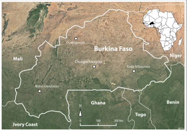
Burkina Faso is a land-locked country in the West African Sahel belt and shares borders with Mali, Niger, Benin, Togo, Ghana and Ivory Coast (Fig. 1.1). The climate is hot and semi-arid, with rainfall restricted to a monsoon season in June – September. A rough NE-SW rainfall gradient exists, with average total annual precipitation of ~450 mm in the far north-east to ~1100 in the south-west (Source: Direction de la Météorologie du Burkina). Three quarters of the land surface of Burkina Faso belongs to the Volta watershed and is drained by the Mouhoun (Black Volta), Nakambé (White Volta) and Nazinon (Red Volta). The original savannah and steppe vegetation has largely been decimated by livestock grazing, agriculture and firewood collection (Stéphenne & Lambin, 2001). 70% of Burkina Faso’s population of 19 million (United Nations, 2017b) still live in rural areas and chiefly rely on rain-fed 5
1.6 Study site
subsistence agriculture of millet, sorghum, maize, cotton, beans and peanuts. In the last decades, numerous small dams have been constructed to catch surface runoff during the monsoon. Along their shores, more irrigation-intensive crops such as rice, fruits and market garden vegetables are cultivated.
Fig. 1.1 Geographical location of Burkina Faso
The geology of Burkina Faso is dominated by Paleoproterozoic crystalline basement rocks belonging to the West African craton and covering roughly three quarters of the country. Volcanic and meta-sedimentary rocks of the Birimian Formation (2240 – 2170 Ma) were intruded by massive granitic batholiths during the Eburnean orogeny (2210 – 1800 Ma) (Castaing et al., 2003a). The Birimian formation has undergone considerable mineralisation, leading to the formation of mineral deposits, particularly gold (Au) in hydrothermal quartz-sulphide veins or disseminated in the host rock.
1.6.1 Hydrogeology
Millions of years of intense in-situ bedrock weathering have formed a dense fissure and fracture network that now constitutes the aquifers of the region (Lachassagne et al., 2011; 6
Soro et al., 2017). Shallow groundwater (down to ~20 m below ground level) can be found in the highly weathered, clayey saprolite, but is vulnerable to drops in water level during the long dry season and to anthropogenic pollution from human settlements and agricultural activities (Huneau et al., 2011; Nikiema et al., 2010). The deeper, fractured bedrock aquifer represents a more secure groundwater resource. In general, groundwater levels are lower in the arid north of the country (~25-35 m b.g.l.) as opposed to the more humid south (~5 – 15 m b.g.l.) (Filippi et al., 1990). Estimations of annual groundwater recharge are scarce for Burkina Faso. Filippi et al. (1990) made recharge estimations using water balance-based hydrological models for nine sites throughout the country, estimating 47 mm/a for the most arid site (annual rainfall ~500 mm) and 260 mm/a for the most humid site (~1100 mm annual rainfall), but the authors also argue that these values may be overestimated. Apambire et al. (1997) and Dapaah-Siakwan and Agyekum (2008) cite sources that propose annual recharge between 2.5 – 4 % of annual precipitation, which seems more reasonable and also corresponds to figures given by Martin and Van De Giesen (2005). Little is known about the exact recharge mechanisms. Stable isotope investigations (2H, 18O) show that water generally does not
undergo significant evaporation (e.g. due to prolonged surface exposure) before recharge, and that the strong rain events at the height of the rainy season contribute most significantly to groundwater recharge (Huneau et al., 2011; Jasechko & Taylor, 2015). The fractured aquifers respond very differently to precipitation due to highly heterogeneous physical aquifer properties, with delays of between one to four months seen until groundwater levels react to the monsoon (Compaore et al., 1997; Filippi et al., 1990; Tirogo et al., 2016).
1.6.2 Rural drinking water supply
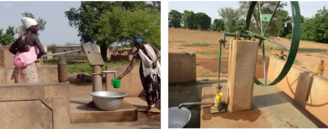
Due to a lack of perennial surface water resources, rural drinking water production relies heavily on groundwater from these aquifers. Tube wells with depths between 30 – 90 m and equipped with hand pumps tap groundwater from fractured bedrock (Courtois et al., 2010), while dug wells with depths < 25 m reach shallower aquifers in the weathered saprolite (Fig. 1.2). The yields of these wells are not very high, typically between 1 – 5 m3/h (Courtois et al.,
2010).
Groundwater quality has, until recently, not been thoroughly investigated in Burkina Faso. Only in 2004 did a study in the northern province of Yatenga reveal that numerous tube wells were affected by As concentrations above the WHO guideline value of 10 µg/L, with maximum measured concentrations of up to 1630 µg/L (COWI, 2004; Smedley et al., 2007).
1.7 Objectives
Fig. 1.2 Examples of hand pump types commonly installed in tube wells in Burkina Faso. The picture on the left shows an “India” hand pump, on the right a “Volanta” hand pump.
A high prevalence of skin lesions was also observed in villagers drinking water from high-As sources (Barro-Traoré et al., 2008; Somé et al., 2012). Smedley et al. (2007) attributed the elevated As to stem from sulphide minerals in auriferous zones, as occur in the Birimian volcano-sedimentary rocks. Generally good water quality with respect to drinking water standards (except NO3-) was found in shallow dug wells by Nikiema et al. (2010) and (2013).
Overall, many open questions still exist concerning the origin and dynamics of As concentrations in aquifers of Burkina Faso.
1.7 Objectives
This dissertation attempts to advance scientific understanding on the overarching topic of arsenic-affected groundwater in Burkina Faso on multiple spatial and temporal scales and using a diverse set of methods. The following broad research questions were addressed:
1) What is the magnitude of geogenic As contamination in Burkina Faso, which regions are especially at risk and how many people are potentially affected?
2) Do temporal aspects such as groundwater residence time and seasonal fluctuations have an influence on the occurrence, distribution and concentrations of As in fractured crystalline bedrock aquifers?
3) Which low-cost, low-tech technologies are suitable for As drinking water treatment in Burkina Faso? Can zero-valent iron-based household filters effectively remove As below 10 µg/L?
These objectives are addressed in three separate studies that compose the main research chapters of this thesis and are herewith briefly outlined:
Groundwater arsenic contamination in Burkina Faso, West Africa: Predicting and verifying regions at risk (Chapter 2):
In many countries, field testing of groundwater As concentrations lags behind due to a lack of resources such as funding, equipment and know-how. Hazard prediction maps identifying regions which are most at risk and should be prioritised in drinking water surveys can be useful tools for authorities and scientists alike (e.g. Ayotte et al. (2006); Rodríguez-Lado et al. (2013); Winkel et al. (2008)). Multivariate logistic regression was used to find the statistically most significant predictors for groundwater As from a range of independent geological and mineralogical variables. The model was calibrated and validated with As measurements from various regions in Burkina Faso. By combining population density data with the resulting hazard maps, estimations of the number of people potentially exposed to As-contaminated groundwater in Burkina Faso could be made.
Hydrogeochemical and multi-tracer investigations of arsenic-affected aquifers in semi-arid West Africa (Chapter 3):
Apart from the hypothesis that As stems from sulphide minerals in auriferous zones (Sako et al., 2016; Smedley et al., 2007), little is known about the processes governing As occurrence in the West African fractured bedrock aquifers. Especially the influence of groundwater residence time and seasonal monsoon precipitation on As concentrations has not been investigated. In order to capture small-scale variability, field measurements and sampling was carried out in a small study area (~80 km2) in south-western Burkina Faso. In addition to
major ions, trace elements and stable isotopes (18O, 2H), dissolved noble gases were sampled
for the first time in these shallow to moderately deep fractured aquifers. 3He/4He ratios gave
new insights on groundwater residence time, leading to an improved conceptual model of groundwater As occurrence.
Arsenic removal with zero-valent iron filters in Burkina Faso – field and laboratory insights (Chapter 4)
Arsenic mitigation activities are still largely unexplored in Burkina Faso, but increasing interest from authorities, NGOs and donors has shown the necessity of viable solutions. Currently, tube wells identified as contaminated are closed by the authorities, often without replacement. 9
1.7 Objectives
Building up on the efficient As removal of the Fe(0)-based SONO household filter in Bangladesh (Hussam & Munir, 2007; Neumann et al., 2013), it was hypothesised that similar systems can be effective in Burkina Faso, considering that groundwater contains As(V) and has an optimal pH-range (6.5 – 7.5) for As adsorption to Fe(0). A key to the success of the SONO filter is its composite iron matrix, composed of fine iron shavings. A similar material, free from oily residues, could not be located in Burkina Faso. Pilot filters were therefore constructed with small, locally available iron nails as an Fe-oxide source and tested for nine months in households with highly contaminated tube wells (~400 - ~1300 µg As/L). In parallel, a laboratory study with filter columns enabled testing different filter set-ups and finding the optimal conditions for As removal with respect to flow rate, contact time and pH. Despite their distinct topics and stand-alone character, the chapters are nevertheless connected and build up on each other. The broad, country-scale assessment presented in Chapter 2 gives a first overview of the magnitude of As contamination and serves as a foundation for the two follow-on studies. The large spatial heterogeneity in As occurrences warranted a more detailed, catchment-scale approach (Chapter 3) allowing an evaluation of dynamic processes not covered by the static, low-resolution geological data of Chapter 2. Finally, the third study addresses As mitigation on the scale of single households and tube wells and with a temporal resolution of days, detail that is necessary to capture fluctuations in a filter’s performance.
The principal findings of this thesis and their relevance are discussed in Chapter 5, including suggestions for future fields of research.
2 Groundwater arsenic contamination in Burkina
Faso, West Africa: Predicting and verifying
regions at risk
_________________________________________________________________________ Anja Bretzler, Franck Lalanne, Julien Nikiema, Joel Podgorski, Numa Pfenninger,
Michael Berg, Mario Schirmer
Science of the Total Environment 2017, Vol. 584-585, pg. 958-970
Abstract
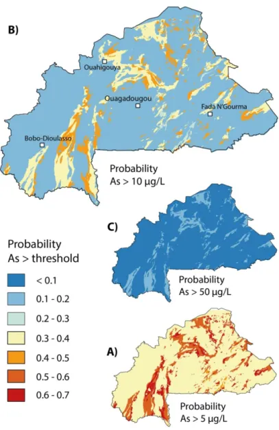
Arsenic contamination in groundwater from crystalline basement rocks in West Africa has only been documented in isolated areas and presents a serious health threat in a region already facing multiple challenges related to water quality and scarcity. We present a comprehensive dataset of As concentrations from drinking water wells in rural Burkina Faso (n=1498), of which 14.6% are above 10 µg/L. Included in this dataset are 269 new samples from regions where no published water quality data existed. We used multivariate logistic regression with As measurements as calibration data and maps of geology and mineral deposits as independent predictor variables to create As prediction models at concentration thresholds of 5, 10 and 50 µg/L. These hazard maps delineate areas vulnerable to groundwater As contamination in Burkina Faso. Bedrock composed of schists and volcanic rocks of the Birimian formation, potentially harbouring As-containing sulphide minerals, has the highest probability of yielding groundwater As concentrations >10 µg/L. Combined with population density estimates, the As prediction models indicate that ~560,000 people are potentially exposed to As-contaminated groundwater in Burkina Faso. The same As-bearing geological formations that are positive predictors for elevated As concentrations in Burkina Faso also exist in neighbouring countries such as Mali, Ghana and Ivory Coast. This study’s results are thus of transboundary relevance and can act as a trigger for targeted water quality surveys and mitigation efforts.
2.1 Introduction
2.1 Introduction
Despite the increased construction and development of centralised water distribution systems and piped water supplies in sub-Saharan Africa during the last decades, small-scale groundwater abstraction via hand-dug wells or village hand pumps is often the sole source of drinking water for rural populations (MacDonald et al., 2009; Martin & Van De Giesen, 2005). Especially in the arid and semi-arid regions of the Sahel belt, where surface water resources can dry out completely in the long dry season, rural areas rely on groundwater for their drinking water supply (Edmunds, 2008). In general, groundwater is regarded as having good drinking water quality and to be predominantly free of pathogens, but chemical constituents may present a hazard that is often discovered late or not at all due to insufficient testing and surveying of water quality (MacDonald & Calow, 2009; UNICEF, 2008).
This is the case for As, which can occur naturally in groundwater in concentrations that can lead to serious and chronic health effects after prolonged consumption (Naujokas et al., 2013). As exposure has not only been linked to the development of a variety of cancers, but also to developmental, neurological, respiratory and cardiovascular effects (Argos et al., 2010; Naujokas et al., 2013; Yuan et al., 2010; Yuan et al., 2007). The World Health Organisation (WHO) has imposed a drinking water guideline concentration for As of 10 µg/L, which has also been adopted by Burkina Faso (MAHRH/MS, 2005; WHO, 2011). Large-scale geogenic contamination of groundwater with As in South and Southeast Asia (e.g. Bangladesh, India, Cambodia, Vietnam) has received a lot of attention in the last two decades (e.g. Bhattacharya et al. (1997); Flanagan et al. (2012); Smith et al. (2000), Berg et al. (2007)). The phenomenon is still relatively unknown and little studied in West Africa though (Ahoulé et al., 2015), where fractured aquifers composed of weathered crystalline bedrock predominate. This is a totally different system to the young sedimentary aquifers of As-affected regions in Asia, where As is released by reductive dissolution (Ahmed et al., 2004). Studies in Ghana and Burkina Faso have shown that the oxidation of As-containing sulphide minerals found in rocks of the Birimian formation is the primary process responsible for high As levels found in some groundwater (Asante et al., 2007; Barro-Traoré et al., 2008; Buamah et al., 2008; Sako et al., 2016; Smedley, 1996; Smedley et al., 2007; Somé et al., 2012). However, an understanding of the extent of the problem and a detailed investigation of the sources and geological conditions leading to As contamination is currently lacking.
Since testing wells for As contamination is expensive and time consuming, maps identifying areas that are especially vulnerable to this kind of pollution are largely missing. However, they would be a useful tool for decision makers by helping to focus efforts where they are most needed. Such groundwater vulnerability assessment and mapping is a growing field, with more and more studies focussing on finding methods to assess the vulnerability of aquifers to contaminants such as nitrate or pesticides (Nolan & Hitt, 2006; Nolan et al., 2002; Ouedraogo et al., 2016; Sorichetta et al., 2013).
Specifically concerning As, statistical modelling to predict the spatial occurrence of As and highlight areas where safe drinking water predominates has been performed successfully at different scales, from global to regional, and in a range of different geological terrains (Ahn & Cho, 2013; Amini et al., 2008; Ayotte et al., 2016; Ayotte et al., 2006; Dummer et al., 2015; Rodríguez-Lado et al., 2013; Shamsudduha et al., 2015; Winkel et al., 2008; Winkel et al., 2011; Yang et al., 2012). Fundamental to the development of such models is knowledge of the geochemical processes leading to the occurrence of high As in groundwater, as well as finding the predictor variables (proxies) to explain these. Since geogenic As is by definition of geological origin, such proxies are usually geological variables, but various environmental parameters, such as temperature or precipitation, that influence geochemical processes in groundwater may also be relevant (Amini et al., 2008).
The concentration of As in groundwater is not only related to the abundance of As found in minerals in the aquifer matrix, it is also a function of solubility, which is governed predominantly by pH and redox conditions (Dixit & Hering, 2003; Hug & Leupin, 2003). In China, for example, Rodríguez-Lado et al. (2013) found elevated groundwater As concentrations in sedimentary basins and river valleys to be strongly associated with Holocene sediments, soil salinity, fine subsoil texture and an elevated Topographic Wetness Index, which functioned as proxies for chemically reducing environments with high As solubility. In the case of As release due to sulphide mineral oxidation in crystalline basement rocks, different proxies must be taken into account, as has been shown by Ayotte et al. (2006), Yang et al. (2012), Ahn and Cho (2013) and Dummer et al. (2015) who modelled a positive correlation between As occurrence and certain mineral-bearing geological formations.
The goal of this study is to investigate the distribution and magnitude of geogenic groundwater As concentrations in Burkina Faso in order to better identify affected areas and populations. We carried out a country-wide As survey and created As prediction models based on three different concentration thresholds (5, 10 and 50 µg/L) taking into account the
2.2 Hydrological and geological setting and its relevance to elevated As concentrations
geochemical processes and conditions responsible for elevated As in groundwater in West Africa. The models were calibrated using a spatially limited As measurement dataset and then validated with measurements from other regions in Burkina Faso to ensure country-wide validity. As is often the case in developing countries, datasets of physical parameters such as geology, hydrogeology, mineral resources and climate were not available to the same extent or resolution as in industrialised nations. For this study, only surface parameters were available. The depth of individual boreholes and lithological logs were not available. Therefore, another goal of this study was to investigate whether a reliable hazard model for As can be produced in light of data scarcity. Due to the large number of countries in the West African region and the difficulty in collecting the necessary data for each individual country, we chose a single “model” country for which to create As prediction models. Burkina Faso was selected because some existing studies already show elevated groundwater As but are limited in their spatial extent (Barro-Traoré et al., 2008; COWI, 2004; Nzihou et al., 2013; Ouédraogo & Amyot, 2013; Sako et al., 2016; Smedley et al., 2007; Somé et al., 2012). The same geological formations that harbour As-containing sulphide minerals in Burkina Faso are also found in neighbouring countries such as Mali, Niger, Ivory Coast, Ghana and Benin (Schlüter, 2008). Therefore, this study is relevant to the greater West African region and should spur increased discussion and mitigation efforts concerning As contamination and its health effects.
2.2 Hydrological and geological setting and its relevance to
elevated As concentrations
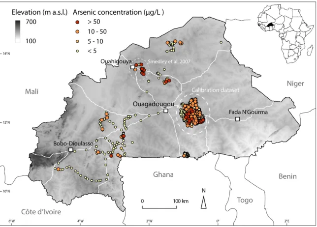
Burkina Faso has a hot and dry semi-arid climate, with rainfall restricted to one rainy season per year from June to September. Rainfall is higher in the south-west than in the more arid north and east. Groundwater recharge occurs during the rainy season with smaller total amounts in the north than in the south-west, but can be spatially highly heterogeneous (Filippi et al., 1990; Martin & Van De Giesen, 2005). Geomorphologically, Burkina Faso is relatively flat, with most of the country lying between 250 and 400 m a.s.l. (Fig. 2.1). 65% of the land area of Burkina Faso is covered by the Volta basin and is drained by the Mouhoun, Nazinon and Nakambé rivers (Black, Red and White Volta) (Martin & Van De Giesen, 2005).
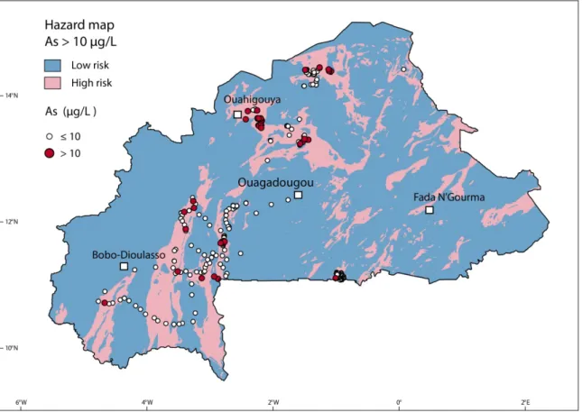
Fig. 2.1 Overview of the study area, giving the location of groundwater As measurements used in this study (n=1498). The calibration dataset from the Province of Ganzourgou (source: Unicef/BUMIGEB) is represented by the large cluster of points east of Ouagadougou (n=1184). The remaining points comprise the validation dataset (n=314), which includes data from Smedley et al. (2007) (n=45) and the new measurements presented in this study (n=269).
Between the in-tact crystalline bedrock at depth and the ground surface, a typical tropical hard-rock weathering profile exists and controls the local hydrogeological properties, explained in more detail in Courtois et al. (2010) and Nikiema et al. (2013). The top few metres of the ground surface are usually composed of a laterite crust, underlain by a few tens of metres of weathered clayey saprolite, which represents the upper part of the aquifer. This then merges into the so-called fissured layer (densely fissured and fractured weathered bedrock), which can extend to a depth of 80-100 metres below ground level and acts as the main aquifer for groundwater storage (Courtois et al., 2010). In rural areas, boreholes for drinking water abstraction with hand pumps are drilled into the fissured layer and have depths ranging from 35-90 metres. Hand-dug wells tapping shallower aquifers in the weathered saprolite layer may also be used for drinking water purposes.
2.2 Hydrological and geological setting and its relevance to elevated As concentrations
A large part of Burkina Faso is covered by Paleoproterozoic crystalline basement rocks. These comprise belts of (meta-)volcanic, metasedimentary and plutonic rocks of the Birimian Formation, as well as large intrusive bodies of Eburnean granitoids (granite, tonalite, granodiorite) (Fig. 2.2). The Birimian volcano-sedimentary belts (also known as Birimian greenstone belts) were formed as part of an island-arc system between 2240 and 2170 Ma. They are composed of varied volcanic and plutonic rocks, including basalt, andesite, rhyolite and gabbro, that occur next to schists, quartzite and chert (Castaing et al., 2003a). The Birimian formation has undergone considerable mineralisation that was synchronous with regional metamorphism and deformation. This led to the formation of high-grade ore deposits, primarily gold and to a lesser extent other metallic ores. Gold deposits principally occur within or adjacent to quartz veins that formed later than the host rock (Béziat et al., 2008). Native gold can occur directly within deformed quartz veins, or as gold particles disseminated in the alteration halos of unfolded quartz veins. Both mineralisation types are directly associated with the occurrence of sulphide minerals such as pyrite (FeS2) and
arsenopyrite (FeAsS) (Béziat et al., 2008; Bourges et al., 1998; Castaing et al., 2003a). Pyrite can incorporate minor and trace elements into its mineral structure and As concentrations in pyrite can occur up to 10 wt% (Abraitis et al., 2004). The oxidation of such sulphide minerals when in contact with oxygen-containing groundwater and subsequent release of As to solution can lead to considerably elevated groundwater As concentrations (Verplanck et al., 2008; Walker et al., 2006; Yang et al., 2015). In general, depending on the redox conditions in the subsurface, As should stay in solution in its reduced form As(III) if reducing conditions are prevalent, but should be tightly adsorbed to iron hydroxides if conditions are oxidising (Dixit & Hering, 2003). Nevertheless, Smedley et al. (2007) measured clearly elevated As concentrations in oxidising groundwater in Burkina Faso and hypothesised that these high concentrations occur in the direct vicinity of mineralised zones where the As loading in groundwater can be very high locally.
Fig. 2.2 Simplified geological map of Burkina Faso, showing the main rock types, major faults and the location of mineral deposits (metal ores). Modified from Castaing et al. (2003b)
2.3 Methods
2.3.1 Data collection and processing
2.3.1.1 Arsenic concentration measurements
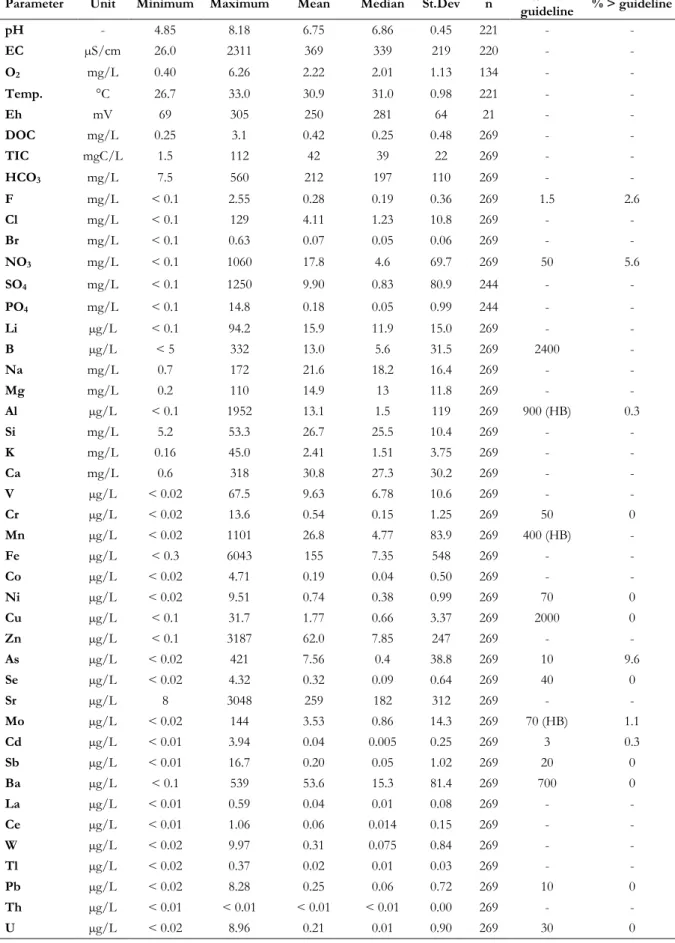
A dataset (n=1498) of georeferenced groundwater As concentration measurements from boreholes in rural areas was used in this study to calibrate and validate the As prediction model (Fig. 2.1). The dataset includes both new and existing data (Table 2.1). Included in the 1498 measurements are 269 new groundwater samples taken specifically for this study from 2014 to 2016 in different regions of Burkina Faso (Table 2.1, Fig. 2.1). Samples originate from village boreholes equipped with hand pumps (types India, Volanta or Vergnet). We followed standard sampling and laboratory analysis procedures as described in similar studies (Berg et 17
2.3 Methods
al., 2008; Buschmann et al., 2007). On-site parameters (temperature, pH, electrical conductivity, O2 concentration and redox potential) were measured in a flow-through cell
connected to the pump spout. Water sampling was performed after on-site parameters had stabilised, generally after 5-10 minutes. All sampled boreholes are pumped nearly continuously during the day by local residents for drinking water production, hence water was never stagnant in the pipes during sampling. Samples for major cations and minor and trace element analysis (including As) were collected in acid-washed polypropylene bottles, filtered through 0.45 µm filters and acidified with concentrated HNO3 suprapure to a pH < 2. An unfiltered,
non-acidified aliquot was collected for analysis of anions, DOC and TIC. Samples were stored below 4°C whenever possible. Analysis was performed in the laboratories of Eawag, Switzerland, using ICP-MS (Agilent 7500 cx) for cations and trace elements, ion chromatography for anions (ICS-2001 Dionex) and a carbon analyser (TOC Shimadzu) for TIC and DOC.
Table 2.1 Arsenic concentration measurements (n=1498) used for model calibration and validation
Province No. of samples % > 10 µg/L As Source
Calibration data Ganzourgou 1184 15.5 % Unicef/BUMIGEB
Validation data Yatenga 45 42 % * Smedley et al., 2007
Nahouri 52 2 % This study
Soum 38 13 % This study
Balé 31 16 % This study
Various (South-West) 101 9 % This study
Bam 22 14 % This study
Boulkiemdé 15 0 % This study
Various 10 20% This study
* Non-random sampling specifically targeting As-affected boreholes
Also included in the total dataset of 1498 samples are 1184 As measurements obtained through a study commissioned by Unicef Burkina Faso and carried out by the “Bureau des Mines et de la Géologie du Burkina” (BUMIGEB) in 2010 to measure As concentrations in drinking water boreholes in the province of Ganzourgou, 50 km east of Ouagadougou (Table 2.1). Samples were measured in the laboratories of BUMIGEB using Atomic Absorption Spectroscopy (AAS). Depths of individual boreholes are not known, however a separate 18
database of 434 boreholes from the province of Ganzourgou contains depths ranging from 35 to 90 metres, with a mean of 51 metres. In addition to the Ganzourgou data, 45 As measurements from the Ouahigouya region (Yatenga province) in northern Burkina Faso were provided by Smedley et al. (2007).
2.3.1.2 Model variables
Independent predictor variables
Georeferenced map data with a country-wide coverage were considered as predictor variables for the As prediction model. As groundwater As in Burkina Faso is thought to originate from sulphide minerals in mineralised zones, focus was set on assembling predictor variables that could indicate such mineralisation, such as lithological variables and distances to mineral deposits, faults and granitic intrusions (Table 2.2). The Geological and Mineral Deposit Map of Burkina Faso at a scale of 1:1,000,000 (Castaing et al., 2003b) was used to extract major lithologies, faults and the location of mineral deposits of metal ores (e.g. gold, zinc, chromium, manganese) (Fig. 2.2). In addition to the location of mineralised zones, groundwater flow and residence time may also play a role in As concentrations. Due to the heterogeneity of fractured bedrock aquifers, mapping such parameters on a regional or country-wide scale is problematic (Dewandel et al., 2012). As possible proxies for hydrological processes related to groundwater flow and residence time we chose the “drainage direction” and “flow accumulation” datasets of the Hydrosheds database (Lehner et al., 2008). These data are derived from the digital elevation model (DEM) of the Shuttle Radar Topography Mission (SRTM).
The predictor data layers were converted to raster format (if originally in vector format such as polygon, line or point) with a resolution of 30 arc seconds (1 km on the equator) using standard tools available in the open source QGIS and GRASS software packages (GRASS Development Team, 2015; QGIS Development Team, 2015). The distances to faults, mineral deposits, and granitic rocks were calculated within a buffer zone of a maximum of 10 km away from the feature.
2.3 Methods
Table 2.2 Predictor variables used in the As prediction model
Predictor variables Type Format Source Volcano-sedimentary schist
(Birimian) Categorical Polygon BUMIGEB/BRGM (Castaing et al., 2003b)
Volcanite: basalt, andesite,
rhyolite (Birimian) Categorical Polygon Orthogneiss (Birimian) Categorical Polygon
Granite Categorical Polygon
Tonalite Categorical Polygon
Distance to faults Continuous Raster
Distance to mineral deposits
(metal ores) Continuous Raster Distance to granitoid rocks Continuous Raster
Drainage direction Continuous (30 arc seconds) Raster HydroSHEDS/WWF (Lehner et al., 2008)
Flow accumulation Continuous (30 arc seconds) Raster
Dependent variable (Arsenic concentration measurements)
In order to be compatible with the predictor variables, the calibration dataset of As concentration measurements was converted from point to raster format and concentrations aggregated to one value per 1 km2 pixel by using the maximum As concentration if more than
one measurement fell into the pixel. We chose the more conservative maximum value instead of averaging concentrations in order to ensure that high-As boreholes remain in our analyses and are not “diluted” by surrounding low concentrations. As such, the original calibration dataset of 1184 individual As measurements was reduced to 877 measurements, with 39% above 5 µg/L, 19% above 10 µg/L and 2% above 50 µg/L. The aggregated concentration values were binary-coded according to the chosen threshold (above threshold = 1, below threshold = 0) and used as the dependent variable in the logistic regression model. We chose the threshold values of 5, 10 and 50 µg/L to represent the full concentration range of the dataset. Furthermore, 10 µg/L is the WHO and national drinking water guideline value and therefore of greatest relevance for drinking water. Discussions also exist in Burkina Faso of raising the guideline value to 50 µg/L, a value that is used in some other As-affected countries, such as Bangladesh. The calibration dataset from Ganzourgou Province has a 20
limited spatial extent (4000 km2) but very dense borehole coverage within this area. All
predictor variables are present in this zone and any potential spatial bias is therefore limited. On the other hand, the validation dataset (composed of the 269 new samples described in this study, plus 45 samples from Smedley at al. (2007)), is spatially well distributed and includes locations from the north, south and west of Burkina Faso (Fig. 2.1).
2.3.2 Geospatial hazard modelling
Logistic regression was used to model the probability of As occurring over three concentration threshold values. This method is extensively used in a variety of fields to determine the relationship between a binary dependent outcome variable and a number of independent predictor variables (Hosmer et al., 2013). Specifically, logistic regression models the log(odds), which is defined as the probability 𝑃𝑃 that an event occurs relative to the probability that it fails to occur (1 – P), (e.g. As being above/below the threshold
concentration), as the linear combination of a set of independent predictor variables x1 … xk
with model coefficients β1 … βk (Hosmer et al., 2013):
log(𝑜𝑜𝑜𝑜𝑜𝑜𝐹𝐹) = log �1 − 𝑃𝑃� = 𝛽𝛽0 + 𝛽𝛽1𝑥𝑥1 + … + 𝛽𝛽𝑘𝑘𝑥𝑥𝑘𝑘𝑃𝑃
Removing the logarithm then gives the probability:
𝑃𝑃 = 𝐹𝐹(𝛽𝛽0+ 𝛽𝛽1𝑥𝑥1+ …+𝛽𝛽𝑘𝑘𝑥𝑥𝑘𝑘) 1 + 𝐹𝐹(𝛽𝛽0+ 𝛽𝛽1𝑥𝑥1+ …+𝛽𝛽𝑘𝑘𝑥𝑥𝑘𝑘)
The exponential of the model coefficients exp(β) being greater than 1 indicates an increasing effect of the predictor variable on the dependent variable, while a value less than 1 denotes a decreasing effect.
Logistic regression modelling was carried out within the R statistical environment (R Core Team, 2015). We have followed similar procedures as described in detail in Rodríguez-Lado et al. (2013). Univariate logistic regressions for the three chosen thresholds of 5, 10 and 50 µg/L were performed separately on each predictor variable using the whole calibration dataset as the dependant variable. The drainage direction and flow accumulation datasets were discarded from further analyses as they did not prove to be significant predictors for elevated As at the 21
2.3 Methods
95%-confidence level in the univariate models (p-values > 0.05) (Table 2.3). The orthogneiss, tonalite and “distance to faults” predictors were also not significant (Table 2.3), but were nevertheless kept for further analyses. Orthogneiss belongs to the partly mineralised Birimian formation and could potentially be linked to As contamination, tonalite is a widespread rock type in Burkina Faso with a large spatial coverage (Fig. 2.2) and fault zones as areas of increased fracturing and/or deformation are also hypothesised to be potential proxies for mineralised zones.
Table 2.3 Results of univariate logistic regression models for three concentration thresholds. Significant values at the 95%-confidence level (p < 0.05) are highlighted in bold font
Predictor variables p-values
5 µg/L 10 µg/L 50 µg/L
Volcano-sedimentary schist (Birimian) <0.001 <0.001 <0.001
Volcanite: basalt, andesite, rhyolite (Birimian) 0.01 <0.001 0.99
Orthogneiss (Birimian) 0.22 0.15 0.99
Granite 0.002 <0.001 0.01
Tonalite 0.40 0.06 0.44
Distance to faults 0.67 0.42 0.19
Distance to mineral deposits (metal ores) <0.001 0.87 0.02
Distance to granitoid rocks <0.001 <0.001 <0.001
Drainage direction 0.14 0.63 0.31
Flow accumulation 0.59 0.81 0.93
The remaining eight predictor variables were used for multivariate logistic regression. Instead of single-algorithm models, which are vulnerable to the number and location of the calibration data, we chose to create an ensemble model from numerous base models (ensemble members) for more robust results (Rodríguez-Lado et al., 2013). The calibration dataset was randomly split into training (75%) and testing (25%) portions for multivariate logistic regression with stepwise selection (both directions), whereby predictor variables are automatically retained or removed according to the Akaike Information Criterion (AIC) (Akaike, 1974). This procedure was repeated 100 times, creating 100 models each calculated with a different subset of training data. These models were then used to calculate probabilities for the testing data subsets, whereby the Hosmer-Lemeshow goodness-of-fit test at the 95%-confidence level was applied to assess the accuracy of the model, i.e. whether the model is 22
consistent with the testing data that were not used to calibrate it (Hosmer et al., 2013). Models with a significant Hosmer-Lemeshow test (p < 0.05) indicate that there is no relationship between predicted and observed data. Models with a high p-values (p > 0.05) in this test were therefore retained. Of the remaining ensemble members, a weighted mean of the model coefficients (β1…k) was calculated to generate a final ensemble model for each of the three
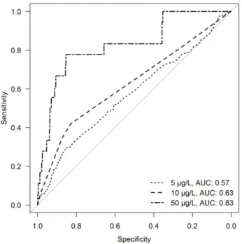
threshold concentrations. Weighting was applied according to the frequency that a predictor variable was retained by stepwise selection in the ensemble members. In this way, predictor variables that occurred frequently in many ensemble members received a higher weighting and greater relative importance in the final ensemble model than variables that were retained in relatively few ensemble members. Variables that were present in less than 5 out of a maximum of 100 ensemble members were not considered for the final model. See Fig. 2.3 for a summary of the above-mentioned procedure. A Receiver Operating Characteristics (ROC) curve was computed on the final ensemble model using the whole calibration dataset to assess how well the model discriminates between low and high risk observations (Fawcett, 2006). For this, the rate of true positives (sensitivity) was plotted against the rate of true negatives (specificity) and the area under the curve (AUC) computed. An AUC value of 0.5 denotes a model that is no better than a random model, and a value of 1 would be a perfect prediction.
Fig. 2.3 Overview of the logistic regression modelling procedure