ADJUSTING STORM-INFLUENCED WIND OBSERVATIONS FOR BAROTROPIC HURRICANE TRACK PREDICTION
by
Wade Douglas Jensen
B.S., Colorado State University (1973)
Submitted in partial fulfillment of the requirements for the
degree of Master of Science
at the
Massachusetts Institute of Technology February, 1978 Signature of Author ... Department of Meteorology,
/
January 17, Certified by Thesis Supervisor Accepted by ... .. ... ...Chairman, Department Committee 1978
FOR BAROTROPIC HURRICANE TRACK PREDICTION by
Wade Douglas Jensen
Submitted to the Department of Meteorology on January 17, 1978, in partial fulfillment of the
requirements for the degree of Master of Science.
ABSTRACT
SANBAR, a filtered barotropic prediction model designed by Sanders and Burpee (1968), relies on an analysis of the wind field averaged through the depth of the troposphere for making hurricane track predictions. The previous and present methods of interpreting storm-influenced rawinsonde
observa-tions are discussed; and a new procedure, which modifies the influenced data, is introduced for use when storms are within 300 nm of land. It is expected that this procedure will
improve the SANBAR forecasts, since the large-scale flow in the storm-influenced region would no longer be constrained to be uniform. Fifty cases from nine tropical storms (1958-1975) were studied. Observations within 85 nm of the storm center were found to be overly sensitive and had to be neglected.
This procedure appears capable of specifying the initial storm-track velocity about as well as present subjective practise. It should prove especially useful when erratic
tracks occur close to landfall.
Thesis Supervisor: Frederick Sanders
Professor of Meteorology
ACKNOWLEDGEMENTS
The author is grateful to Patrick Y. Lui, whose case-study of hurricane Delia, September 1973, ultimately led to this work. Thanks go to Neil D. Gordon for programming assis-tance and for helpful discussions and suggestions during the research. I am especially grateful to Professor Frederick Sanders for proposing the topic; for his advice and guidance throughout the study; and most of all, for increasing my interest in meteorology. Much thanks also to Isabelle Kole for drafting figures, and to Janice Jensen for typing the manuscript.
Page Title Page . . . . . . . . Abstract . . . . . . . . . Acknowledgements . . . . . Table of Contents . List of Figures . . . . . . List of Tables . . . . . . Introduction . . . . . . .
Data Preparation and Objecti Test Cases . . . . . . . .
Discussion and Conclusions Bibliography . . . . . . . 1 2 3 4 5 7 8 11 47 61 64 . . . . . . . . Analysis . . . . . . . . . . . . . . . . . . . . a . . . . . . . . . . . . . .
LIST OF FIGURES
Figure Page
1 a). Effect of varying x . . ... 13 1
b). Effect of varying x2 . . . ... 14
c). Effect of varying x3 ... 15 2. Two different storm wind profiles are shown, with the
observing station positions for hurricane Camille,
August 18, 1969, 1200 GMT also given. . ... 21 3. Correlation as a function of separation distance, for
departures of vertically-averaged wind fran synoptic
zonal average value ... 23
4. Sketch illustrating speed and direction errors . . . . 27
5 a). Initial mean layer winds for hurricane Cindy, July 9,
1959, 0000 GM. ... 32
b). Initial mean layer winds for hurricane Cindy, July 9, 1959, 0000 GMT. This analysis excludes the Charleston
rawinsonde, located about 40 nm fran the storm center. 33 6. Initial mean layer winds for hurricane Camille, August
18, 1969, 1200 GMT . ... 34
7. Initial mean layer winds for hurricane Eloise,
Septem-ber 23, 1975, 1200 GMT ... ... 35 8 a). Oppositely located stations A and B used to estimate
the storm track velocity . . ... 40 b). Same observed winds as in 8 a) , but V9 is now larger
than before ... ... 40 9 a). Stations A and B located equidistant from the storm
center ... . . ... 42 b). Comparison of the vector difference between torm
and Ve with the storm wind direction at stations A
andB ... 42
10. Initial mean layer winds for hurricane Gracie,
11. Initial mean layer winds for hurricane Gracie,
Septem-ber 29, 1959, 0000 GMT . ... . 48
12. Initial mean layer winds for hurricane Camille, August 18, 1969, 0000 GMT . . ... ... . 49
13. Initial nean layer winds for hurricane Helene, Septem-ber 27, 1958, 1200 GMT . ... 50
14. Initial mean layer winds for hurricane Helene, Septem-ber 28, 1958, 0000 GMT . ... . 51
15. Initial nean layer winds for hurricane Donna, Septem-ber 10, 1960, 0000 GMT ... . . . 53
16 a). Velocity specifications for hurricane Delia, September 4-6, 1973 . ... . .... . 55
b). Canpilation of velocity specifications for hurricane Delia . . . . ... .. ... .. 55
17. Initial mean layer winds for hurricane Delia, September 1973: a) 4th 1200 GMT . . ... .... ... .. . 56
b) 5th 0000 GMT . . . . 57
c) 5th 1200 GMT . . . . . . . . . . . . . . . . 58
d) 6th 0000 GMT . . . . 59
LIST OF TABLES
Table Page
1. Frequency of values of parameters chosen to minimize V'. 18 2 a). Interrelationship between X1 and X3 ... 19
b). The effect of the position of the nearest rawinsonde
station on the choice of parameters X1 and X3 ... 19 3. Relationship between errors and the distance to the
nearest observing station . ... . . . . 28 4. How 85 nm was chosen as the minimum separation distance
required before a station will be included in the
analysis ... 29 5 a). Interrelationship between X1 and X3 (10 reruns) ... 30
b). The effect of the position of the nearest rawinsonde station on the choice of parameters X1 and X3 (10
re-runs) ... 30
6. Algebraic mean 12-hour forecast and velocity
specifi-cation errors ... ... 36 7. Homogeneous sample of forecast position errors over
the period 1973-1976 .. . . . . . ... . . .. . ... . 37 8. Frequency of errors ... 37 9. Relationship between errors and the number of observing
stations within 300 nm of the storm . . . . 38 10. Velocity specification errors canpared to the largest
angle not containing any rawinsonde observations within 300 nm of the storm center . ... . . .. ... 46
A filtered barotropic prediction model designed by Sanders and Burpee (1968), known as SANBAR, has been used
operationally at the National Hurricane Center (NHC) since late 1968. The model operates on winds averaged with respect to mass through the troposphere and is used to predict tropical cyclone tracks by following minimum stream function and maximum vorticity centers. The assertion is that the storm is "steered" by the larger-scale current in which it is embedded, as sug-gested by Riehl and Haggard and Sanborn, 1956, and by Jordon, 1952, among others.
Originally, objective analysis was performed on data after subtracting from wind observations near the storm center an idealized, circularly-symmetric vortex specified by the location of its center, and by its maximum wind, eye diameter, and radius of influence. The storm-purged residual winds could then be regarded as a measure of the classical steering effect. All of the parameters except the radius of influence were
reasonably well known initially in real time. The radius of influence, however, was subjectively determined, with results that often seemed unsatisfactory. Even after 300-nm was
adopted as the nominal value to be used, the operationally calculated residual winds were too often unrealistic.
Pike (1972) reported that SANBAR's performance at the 12 and 24 hour forecast times was much worse than that of the statistical forecast methods for the 1971 Atlantic hurricane
season, though SANBAR outperformed the others in long-range 48 and 72 hour forecasts. For a 24 case sample from the 1971 storms, SANBAR forecasts had an average left bias of 28* and a slow bias of 21%, according to Pike. Williams (1972) and
Gaertner (1973) found the slow speed bias but not the direction-al bias in their forecasts made at MIT.
So Pike devised an approach, known as modified-SANBAR, that relied heavily on persistence of past motion. He discarded all observations within the influence region of the storm and substituted a best available estimate of the observed storm motion instead. Then, after the automated analysis, a vortex wind is added to complete the field to be used in subsequent
forecasts. Using the same 24 case sample, Pike's Mod-SANBAR forecasts showed significant improvement, with the directional bias of SANBAR eliminated, and the speed bias reduced.
Gaertner confirmed the improvement and for the 1972 hurricane season, the Mod-SANBAR model was put into use at NHC.
Though implementing past storm movements has improved the general performance of the model, Sanders, Pike and Gaertner (1975) felt that a present limitation on forecast accuracy was an "inability to make consistently good use of information contained in soundings made within the region influenced by the storm." Cases where the storm path is smooth are handled well, but the sudden twists and turns of erratic tracks are not predicted. The 12-hour forecast
6-hour displacement. Rather than present the forecasters at NHC with a 12-hour prediction so similar to those of the
statistical models, which also rely heavily on persistence of past motion for their short range prediction, it is hoped that SANBAR could predict sudden changes in movement more effectively. Forecasters could then subjectively evaluate the validity of
the SANBAR prognosis, if and when it differed significantly from the statistical models, before issuing their advisories.
Wind observations in the storm influenced area must be potentially valuable for the prediction of any sudden changes
in the movement of a tropical storm. However difficult it has been in the past, some effective method for separating the
storm wind contribution from the observed winds is needed. This study is concerned with optimum ways of making such a
11. DATA PREPARATION AND OBJECTIVE ANALYSIS
The SANBAR model relies on an analysis of wind observa-tions, averaged through the depth of the troposphere, and makes no direct reference to the pressure-height data, where errors in lower latitudes are often as large as natural
variability. Rawinsonde data was obtained from Northern
Hemisphere Data Tabulations available at MIT. Layer-mean winds at each reporting station were estimated from the winds at the ten mandatory pressure levels in the layer from 1000 mb to 100 mb by the trapezoidal rule
- 1 8 (pi-1 - Pi+ ) (P - P1) (P8 - P9)
V - V+ V + V
0i=2 2 -0 2 "9
where po = 1000 mb, ... , p9 = 100 mb, and Vi = the horizontal
wind vector for the level specified.
Missing winds at interior levels were interpolated from surrounding levels; winds missing at the top or bottom were given the value of the closest available level. Observations at 1000 mb were found to be the most commonly missing, usually for inland reporting stations. When a sounding reported fewer than two of the lower four levels (1000, 850, 700 and 500 mb) or fewer than two of the upper six levels (400, 300, 250, 200, 150 and 100 mb), it was rejected. Even when wind observations at every 50 mb were available, only the ten mandatory levels were used, following the studies of King (1966) and Ahn (1967), which indicated that the mandatory levels represented an
acceptable vertical sample from which to work.
The idealized, circularly-symmetric tangential wind speed, Ve , to be subtracted from observations within the storm area
is of the form
X 3
Ve = X1 {sin [ O ']}
for 04rS 300 nm and Ve = 0 for r>300 nm ; where
KV () X , r is the radial distance
1 max 2 In(ryjoo)
from the center, V is the maximum observed wind speed
max
near the surface, K is the proportionality factor between this wind and the maximum wind averaged through the depth of the troposphere, and re is the radial distance of Vmax from the center. Speeds are in knots, distances in nm, and 300 nm is considered to be the maximum storm influence distance. In the original version of SANBAR, K = 0.72 and X3 = 1.5
The parameters X1 , X2 and X3 are varied, and a method was devised whereby the rawinsonde observations
them-selves determined which were the "best" values to use. We
allow X1 to vary from 0 to 100; X2 from 0.15 to 0.43 (re ranges from 3 to 60); and X3 from 0.2 to 4.0. Varia-tion of X1 (or Vmax ) affects the magnitude of the curves in Figure 1 a). Different values of X2 lead to a translation of the peak in 1 b), while changing X3 results in significantly altered shapes, as shown in 1 c).
The best set of parameters is taken to be that combination of values which yields the smoothest set of residual
(large-A A
Fig. 1 a) -- Effect of varying x 1 0. 231.6 ;Ve = x 1sin['W( r) r = 15 e 0% 100 200 50 40 (kts) 30 Ve 0 L 0 r (nm) 300
60 50 40 1.6 ; V = 43. 20 sin[e(-- )x2 100 200 r (nm)
Fig. 1 b) -- Effect of varying x2
V = 60 max ,+ + 0o 10 V Ve (kts) 30 20 10 0 300
A ,
0. 23 x3
60- Fig. 1 c) -- Effect of varying x3 ; Ve = 43.20 sin[,'( ') ]
r = 15 ; V = 60 e max 50 40 V (kts) 30- 20- I0-Hrn
O
I
, r (nm) A ,, 3 100 200 300scale) winds defined by V wr =V 0 -
Y
V being thelayer--0 8 0
mean observed wind. To determine smoothness, an interpolated value of the residual wind is calculated for each station and compared to the actual value of Vr at that station. This interpolated wind, Vp , is derived from planar fits of the u- and v-components of the residual wind. The planes are determined by the nearest three observing stations which form a triangle enclosing the station in question. Given the
latitude, longitude and u- (or v-) component of the residual wind at the vertices, we can compute the interpolated u- (or v-) component of V
Now the deviation, V' , of the actual residual wind from the interpolated residual wind can also be calculated at each station. Notice that observations whose enclosing
triangle lies outside the influence region of the storm (300 nm) will always contribute the same value of V . The best set of parameters for a synoptic case is taken to be that which minimizes the root-mean-square value of V1 over all observing stations except the outermost, which cannot be enclosed by any such triangle. Therefore, the smoothest profile is implicitly the one which minimizes the root-mean-square deviation of those observations which have at least one storm influenced vertice.
In effect, the variability of vortex structure is recog-nized, and we accomodate the profile to wind observations in the vicinity of the storm. There should be fewer unrealistic residual winds calculated using this method than were calculated
17.
using the original version of SANBAR. Moreover, the method stops far short of specifying the residual winds, as is done in Mod-SANBAR.
Fifty data sets, for nine tropical storms, were chosen for study. They were picked on the basis of at least two
simultaneous rawinsonde observations being located within the influence region of the storm. On the average, four such
influenced observations were present. Understandably, these storms lay within 300 nm of either the United States coast or parts of the Caribbean islands. As such, they represented especially important forecast problems for NHC. The resulting selection frequencies of the parameters X1 , X2 and X3 are shown in Table 1. Rather surprisingly, in half the instances the implied value of V is no more than 35 kts*, and the
max
shape of the radial profile is very flat, as evidenced by such small values of X3 . The current operational SANBAR value of X3 = 1.5 is exceeded only 20% of the time in the present sample! Apparently the tropical storm is often embedded in a weak cyclonic circulation of large scale, and the strongest winds are rarely sampled by the rawinsonde system, leading to these unexpected results. In Table 2 a) it can be seen that the parameters X1 and X3 are usually both small or they are both large. Table 2 b) shows that the closer the nearest
observing station is to the high energy portion of the storm, the more likely it is that larger values of X1 and X3 will
Table 1
Frequency of values of parameters chosen to minimize V'
Ve = X 1 sin[d 30') 21 3 In 0.5 x = 0. 72V max ' • x 2 - In (r /300) e xlI (kt) N r (nm) e N x 3 N 5 0 3 7 0.2 13 10 8 6 1 0.4 5 15 6 9 5 0.6 3 20 7 12 4 0.8 6 25 4 15 7 1.0 2 30 1 18 1 1.2 6 35 4 21 2 1.4 5 40 2 24 2 1.6 2 45 3 27 2 1.8 2 50 0 30 2 2.0 1 55 0 33 2 2.2 0 60 0 36 1 2.4 0 65 1 39 2 2.6 1 70 2 42 1 2.8 0 75 3 45 1 3.0 2 80 0 48 2 3.2 1 85 2 51 1 3.4 0 90 5 54 1 3.6 0 95 2 57 1 3.8 0 100 0 60 5 4.0 1 Total 50 50 50
19. Table 2 a)
Interrelationship between xI and x3
x3 -xl 5 - 20 25 - 45 65 - 95 0.2-0.6 0.8-1.8 2.0-4.0 Total 4 9 10 23 Total 0 1 5 6 21 14 15 50 Table 2 b)
The effect of the position of the nearest rawinsonde station on the choice of parameters x1 and x3 Closest station (nm) 0- 50 51 - 100 0.2-0.6 0.8-1.8 2.0-4.0 Total 101 - 150 151 - 200 201 - 250 251 - 300 Total 3 7 4 2 21 6 4 3 3 23 x1 5- 20 25- 45 60- 95 Total 0- 50 51 - 100 101 - 150 151 - 200 201 - 250 251 - 300 Total 3 0 2 14 1 3 2 11 7 5 15 50 2 0 0 0 6 11 7 5 50
be chosen. The number of influenced observations did not appear to have any particular relationship to the parameters that were chosen, however.
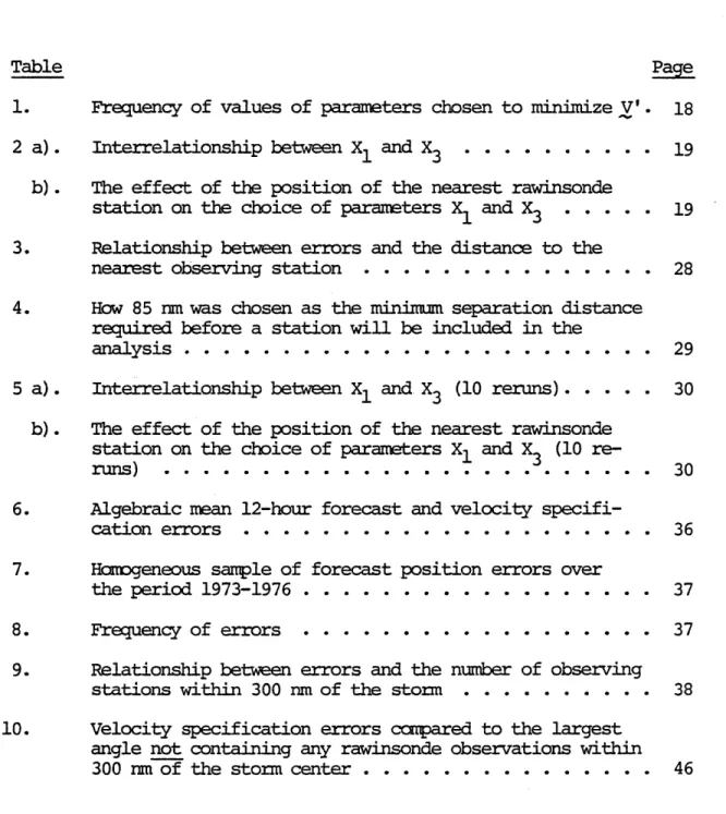
These dependent features of the parameters X1 and X3 are well illustrated by referring to Figure 2, where two quite different storm wind profiles are pictured. Also shown on the profiles are the relative positions of the observing stations for this particular case. The taller curve, with large values of X1 and X3 , was chosen when the nearby observation at station 72235 was included in the analysis. On the other hand, the flatter curve was picked when that observation was not used. Such flat curves, with the nearest observing station over 150 nm from the storm center, were quite common for our 50 case
sample. It seems that the predominance of the smaller values of X1 and X3 in Table 1 is therefore at least partly
explained by the locations of the nearest rawinsonde stations. It is also evident that for synoptic cases where storm influenced rawinsonde observations are concentrated at one
distance from the storm (as often happens), radically different profiles could have practically identical storm winds at the observation locations. This would be the case when the observ-ing stations happened to cluster near the points of intersection of the profiles. In Figure 2, the maximum discrepancy is only about 5 knots (neglecting station 72235). The locations of the observing stations would certainly seem to be an important
factor in determining which values of the parameters are "best". So we should not attach too much importance to the parameter
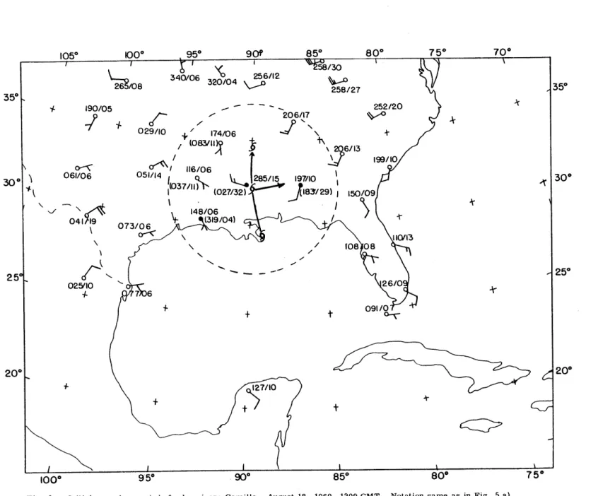
Fig. 2 -- Two different storm wind profiles are shown, with the observing station positions for hur-ricane Camille, August 18, 1969, 1200 GMT also given. 75 60 X = 75 , re = 60, X3 = 2.6 45- In co Ve (kts) 30- i X = 25, re 6, X3 0.4 10 SI I I r (nm) 0 too 200 30 300 0 IOO 200
selection frequencies without also taking the observing station locations into account.
Now, the values of the residual wind, V , should also provide a good specification of the storm track velocity at the time of the observations. We hope that this specification will be as accurate as the operational estimate made in real time by NHC for the official advisories. So a value of V at the location of the storm center was determined, for the optimum set of storm parameters, by stepwise screening regres-sion for both the zonal and meridional wind components, given the values of Vr at each observing station.
Any grid-point best estimate of V at the storm grid-point depends on correlations between the hurricane's position and each of the stations, and also upon correlations between stations, since they do not contribute independently to the estimated grid-point value. So correlation coefficients as a function of separation distance were needed. Two samples of
soundings used to compute such correlations are shown in Figure 3.
For use in this analysis, an average of those profiles was determined and approximated by the exponential function
r(d) = ae- b d 2 where a = 0.93 , b = 6.0 , and a separation
distance of 100 nm means d = 0.1 . Since this curve only
approaches the value of zero asymptotically, it was modified such that r(d) = 0 for d 0.7 (or 700 nm)*. The present * Note that a similar effect could be produced by including a factor such as a~.~ rcos(t , which has a value near unity for
23.
Figure 3
Separation distance (nautical miles)
Correlation as a function of separation distance, for departures of vertically-averaged wind from synoptic zonal average value. Curve designated A was derived from a data sample of 1799 soundings on selected hurricane days from 1960 to 1967. Curve designated B was derived from a sample of 1713 soundings from 6-13 September 1971. For the exponential function (dotted curve), d=0. 1 corresponds to a separation distance of 100 nm . (All but the exponential function from Sanders et. aL, 1975.)
analysis makes use of all rawinsonde observations within 700 nm, the distance corresponding to zero correlation.
To compute the regression equations, distances from
station to station and from station to hurricane were determined for each case. These distances were then converted to the
appropriate correlation coefficients and the symmetric matrix M is constructed (only the upper triangular part is shown),
fdl
rl, 2 d2 rl,3 2,3 d3 rl,k r2,k r 3,k rl r 2 r 3 rk d where r.1 and r. 1,j Initially Theis the correlation between the storm and station i , is the intercorrelation between stations i and
j
dl
= d2 = ... = dk = d = 1.0 .matrix is solved by stepwise regression as follows: 1. Choose the station which gives the best specification, as
measured by the largest fraction of reduced variance 2
ri . Thus, the first specifier chosen is always the
1 closest station.
2. Eliminate that "specifier" by orthogonalizing the remaining matrix.
25. M M.. M* M - ik J11 for j i jk jk M. 11 M* -ik ik M.. 11
3. Re-examine the new matrix to see which station not already eliminated has the largest fraction of reduced variance and eliminate it in the same manner. Note that these will not necessarily be the best pair of specifiers, because the first is already fixed. This second specifier is the one which, in combination with the first chosen, gives the best specification. Note also that the second specifier need not be the second closest to the hurricane.
4. Re-examine the new matrix for the next specifier. When none of the remaining stations will improve the specifi-cation by 1% or more, the elimination process is finished and the regression equation is given in terms of the
eliminated variables. The coefficients of the specifiers are the r.'s of the transformed matrix and the fractional1 unexplained variance is d
With these specifiers and coefficients, a storm-track
velocity can then be computed. For the fifty data sets studied, an average of 4.3 stations were used for this computation, 3.0 with positive coefficients. (Negative coefficients are the
individual synoptic case, a comparison was made between this specified initial track velocity emerging from the regression analysis and an estimate of the actual initial velocity. The estimate was obtained from best track information; namely a
tangent to the track with a speed computed by averaging the
distances traveled in the preceding and succeeding 12-hour peri-ods. The best tracks were taken from annual Monthly Weather
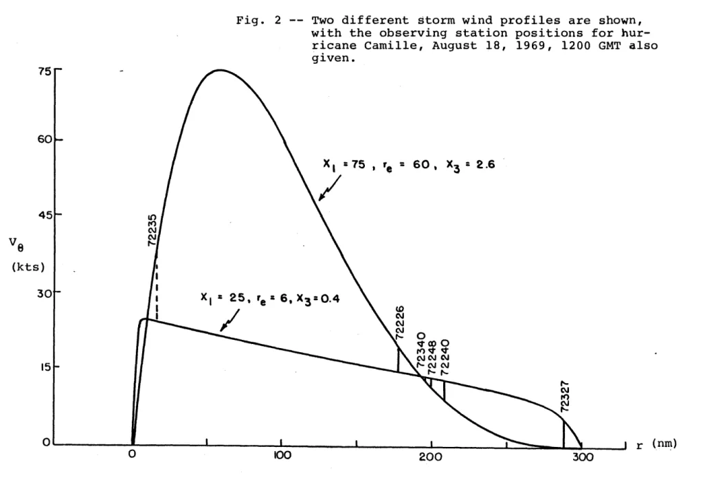
Review articles on the previous hurricane season. Next, a calculation of the errors that would have ensued from using the regression-specified track velocity as a 12-hour extrapolation forecast was made. Then two aspects of the error vectors
were examined, using the definitions of Sanders and Gordon (1976), and illustrated in Figure 4.
Early in the work, an unexpected development turned up. Whenever the storm center was rather close to a sounding
loca-tion, the regression specification was likely to be quite poor. In such instances, slight changes in the storm location led to quite large changes in the direction of V , and -Vr was therefore quite sensitive to the placement of the hurricane center. Compounding this, these stations also dominated the regression specification due to their closeness. In Table 3, evidence of this relationship between the errors and the
distance to the nearest observing station is presented. After some trial and error, 85 nm was decided on as the cutoff
Direction error Predicted / /Speed error / / Observed displacement / - t---~
Fig. 4 -- Sketch illustrating speed and direction errors
Table 3
Relationship between errors and the distance to the nearest observing station.
Nearest Specification 12-hour prediction
station (nm) # of cases error (kts) error (nm)
0- 85 10 7.9 115 86-120 9 4.3 43 121-140 9 4.3 63 141-170 12 3.4 58 171-210 10 4.0 48 211-300 10 5.2 64 Total* 50 4.2 55
* Excluding the cases from 0-85 nm, which were rerun and are are also included in the table
Table 4 illustrates how 85 nm was arrived at as the
cutoff. After discarding the nearest rawinsonde observations, and proceeding through the entire process again, the errors were compared. Only the case with an observation at 69 nm
exhibited a larger position error, using 85 nm as the cutoff. On the other hand, only one of the six additional cases would have been improved had 100 nm been used as the cutoff.
So the ten cases with observations within 85 nm of the storm center were recalculated, without using these observa-tions, and yielding much improved results. Tables 5 a) and 5 b) are the recalculated versions of Tables 1 and 2, respec-tively. Figure 5 a) shows one of the rerun cases, in which the error was 9 knots. Moderate changes in the storm position
Table 4
How 85 nm was chosen as the minimum separation distance required before a station will be inliided in the nanol cia
Distance to closest rawinsonde (nm) 16 39 59 60 61 67 69 71 78 81 87 89 Storm Camille (8-18-69-12Z) Cindy (7-9-59-00Z) Donna (9-11-60-12Z) Delia (9-6-73-12Z) Cindy (7-9-59-12Z) Delia (9-5-73-12Z) Donna (9-12-60-12Z) Ginny (10-25-63-12Z) Grac ie (9-23-59-12Z) Eloise (9-23-75-12Z) Grac ie (9-24-59-12Z) Grac ie (9-23-59-00Z) y . 7. 9 3. 1 115
* excluding the cases at 87 and 89 nm
Total*
Spe c ific at ion
error (kts) Original Rerun 13.4 1.1 8.8 0.4 7.1 2.8 8.8 3.9 6.4 7.1 2.1 2.7 3.2 4.6 14.5 5.0 5.3 0.0 9.5 3.5 3.5 4.2 2.8 8.8 12-hour prediction error (nm) Original Rerun 165 10 140 35 85 55 150 70 135 100 85 45 70 85 145 65 75 25 95 40 15 30 25 95
Table 5 a)
Interrelationship between xl and x3 (10 reruns)
x3 -x1 5 - 20 25 - 45 65 - 95 0.2-0.6 19 7 0 0.8-1.8 2 8 11 2.0-4.0 Total 21 15 14 50 Table 5 b)
The effect of the nearest rawinsonde position on the choice of the parameters x1 and x3 (10 Closest station (nm) 0 - 50 51 - 100 101 - 150 reruns) x 0.2-0.36 0. .8 2. 0 Total 0.2-0.6 0.8-1.8 2.0-4.0 Total 151 -200 201 -250 251 - 300 Total 0 - 50 51 - 100 101 - 150 151 -200 201 -250 251 -300 Total 12 4 2 26 5-20 0 3 3 11 3 1 5 3 3 21 25-45 0 1 6 5 1 2 21 15 Total 0 0 0 3 xI 60-95 0 2 6 1 3 2 14 Total 0 6 15 17 7 5 50
31.
of less than 20 nm to the north-northeast can result in a nearly perfect specification! But since the ultimate concern of this study is real time operational forecasting, the rather sensitive Charleston observation was eliminated. In Figure
5 b) the specification error is now less than 1 knot.
Figures 6 and 7 show situations where there are observa-tions at 16 nm and 81 nm from the storm center, respectively. Once again, the improvement shown when these observations were
eliminated was substantial. For Figure 6 the specification error was 13 knots, while the rerun error was only 1 knot.
Similarly, the specification error for Figure 7 was 5 knots and the rerun specification turned out to be nearly perfect.
So it seems that we are still unable to make constructive use of observations very close to the storm center. Of course, such rawinsonde observations can only be made at substantial hazard to the individuals involved, and are seldom available. But suppose that aircraft dropsondes were made available for use in operational hurricane forecasting. On the basis of our results, placement of the dropsondes from 100 to 180 nm of the storm center would be much more informative for track predic-tion than releasing them within 50 nm of the center.
The error results, averaged for nine tropical storms, are summarized in Table 6. The mean magnitude of the vector
difference was 4.2 knots, a considerable error since the mean estimated velocity was about 10 knots. The average position
error was 55 nm, the same as the 12-hour errors shown in Table 7*, * From Director's memo on R and D activities at NHC; July 15,
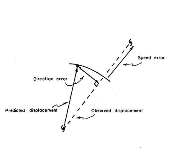
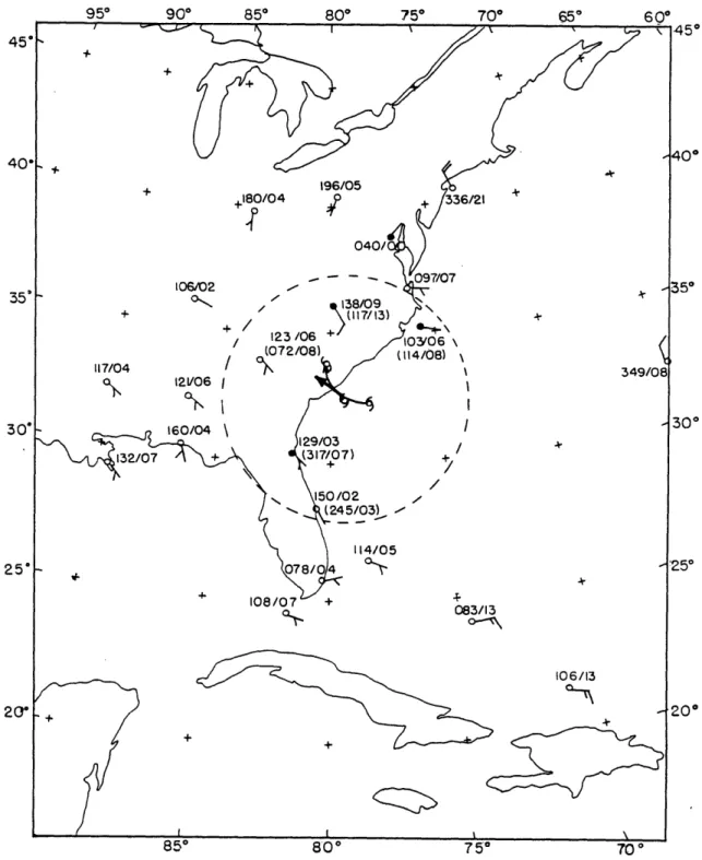
Fig. 5 a) -- Initial mean layer winds for hurricane Cindy, July 9, 1959, 0000 GMT. Hurricane sym-bols show the position of the storm at successive twelve hour intervals. The heavy arrow represents a twelve hour displacement at the specified velocity. Plotted winds represent Vr, also given by numerical notation. For stations within the influence region of the hurricane (dashed circle), values in parenthesis denote the observed wind, Vo .
All winds are indicated in degrees and knots by ddd/ff. Stations with filled circles were used in the regression estimate of the specified velocity.
33.
Fig. 5 b) -- Initial mean layer winds for hurricane Cindy, July 9, 1959, 0000 GMT. This analysis
excludes the Charleston rawinsonde, located about 40nm from the storm center. Nota-tion same as in Fig. 5 a).
300
250
200
1000 v t . U- - ou
Fig. 7 -- Initial mean layer winds for hurricane Eloise , September 23, 1975, 1200 GMT. Notation same as in Fig. 5 a). 350 35" 300 250 200
Algebraic mean 12-hour forecast and velocity specification errors
Year Storm Cases
1958 Helene 6 1959 Cindy 4 1959 Gracie 13 1960 Donna 10 1963 Ginny 4 1969 Camille 5 1973 Delia 5 1974 Carmen 1 1975 Eloise 2 Totals 50
12-hour forecast errors (nautical miles)* Position Speed Direction
65.2 1.4 -29.1 57.5 -5.3 -36.4 43.0 -15.0 7.1 74.3 -12.2 -17.4 62.5 5.4 23.9 36.5 -27.8 -3.6 57.7 -12.6 30.6 54.8 -46. 6 -15.0 32.2 -29.7 -9.1 55.3 -12.3 -4. 1
* Negative values mean too slow a forecast speed, of the observed track.
Track velocity specification
errors (knots)*
Error Speed Direction
5.3 0.8 -1.6 3.6 1.3 -1.9 4.0 -1.8 0.8 5.0 0.0 -1.4 4.9 0.5 0.2 2.7 -2.1 0.2 3.0 -1.2 -0.4 5.4 -4.2 -1.7 4.4 1.6 -4.3 4.2 -0.6 -0.6
37. Table 7
Homogeneous sample of forecast position errors (nm) over the period 1973-1976. Model NHC 67 NHC 72 CLIPER NHC 73 SANBAR Number of cases
Mean 12-hour error 55 53 55 53 56 206 Table 8 Frequency of errors Error range: Track velocity (kts) 0-1. 7 1.8-3. 3 3.4-5.0 5.1-6.7 6.8-8. 3 8.4-10 Frequency 7 9 14 11 4 Error range:
Position error (nm) Frequency
0 - 20 21 - 40 41 - 60 61 - 80 81 -100 101 -120 120 50 Total Total
but perhaps better than current capability in seasons with more erratic tracks than 1973 to 1976.
In Table 8, the frequency distribution shows that mean operational accuracy was probably exceeded about half the
time. The regression procedure, however, occasionally yielded rather large errors. It should be kept in mind that small errors might be the result of things other than good track velocity specification. For instance, slower moving storms could exhibit smaller errors than faster storms merely because of the distances involved, even though the speed and direction might be poorly specified for the former, and rather well
specified for the latter.
Next, some plausible sources of error were examined. In Table 9, the number of observations within the influence region of the storm is shown to affect the specification accuracy.
Table 9
Relationship between errors and the number of observing stations within 300 nm of the storm
Specification 12-hour prediction # of observations # of cases error (kts) error (nm)
2 10 4.6 49 3 14 4.5 71 4 10 4.3 55 5 9 3.3 51 6 6 4.5 40 7 1 2.1 31 Total 50 4.2 55
39.
This is corroborated by the 12-hour forecast position errors in the same table, allowing that the seemingly better results when only two observations were available is probably a
peculiarity of this sample. It should also be kept in mind that the sample cases are not statistically independent, since successive 12-hour situations were studied for 8 of the 9
storms.
It also seemed that an important error source might be the non-uniformity of the observing stations around the storm center. Consider the situation in Figures 8 a) and 8 b), where only the oppositely located stations A and B will be used to
compute the specified storm-track velocity. Given the observed winds at A and B, there is only one possible estimated initial velocity! It makes no difference which storm profile is chosen;
or whether too much, too little, or just enough storm wind is actually subtracted out. No matter how the observed winds are modified, the hurricane winds will always have cancelling
effects, and the estimated hurricane velocity will be implicitly based on the steering flow. The correctness of the estimated velocity would then depend on the correctness of the premise that the storm-wind profile is circularly symmetric, how well the screening regression is able to estimate the large scale flow at the storm center, and how well the storm in fact follows the "steering" principle.
In reality, of course, stations are not uniformly located about a moving storm center. Such storm-influenced stations will generally be located only in that quadrant of the storm
Fig. 8 a)
Oppositely located stations A and B used to estimate the storm track velocity. V0 observed wind V = storm wind V = residual wind V - V -r ~0 06 storm 1 VA +-1 VB V V 2 r 2 "re vo V, r Vr 'I S/ Ve Fig. 8b)
Same observed winds as in a) , but V is now larger than before.
Vr Ve V A-0V v Vr .1 / A B / Vr AI
41. which intersects land. For the 50 case sample, the average angle covered by rawinsondes within 300 nm of the storm center was 1370. In the more realistic situation of Figure 9 a) the stations are no longer oppositely located (though they are still equidistant from the storm center, as a matter of con-venience for this argument). As mentioned before, tropical
storms often seem to be embedded in a larger scale cyclonic circulation. The regression-computed velocity specification will now depend on how much of that circulation is eliminated
from the observations.
First suppose that the large scale steering winds are known to be uniform. In Figure 9 a) these winds are denoted by Ve If not enough circulation is subtracted out, the residual winds, V , certainly differ from the steering
~r
winds. But how does this affect Vstorm ~r , the regression-computed velocity specification? Upon examination of the vector difference between Vstorm and V ~r ,e , we notice an inter-esting characteristic. The direction of the vector discrepancy Vstorm - Ve lies within the "range"* of the
storm wind directions at the influenced stations, as shown by
Figure 9 b). By analogous reasoning, -(Vr - V ) , or
V - V , must lie within that range of storm wind directions
~e -r
when too much storm circulation is subtracted out.
Now the above argument will not be strictly true when observations are not equidistant from the storm. Then there
* Range refers to the smallest sector of the circle of storm influence which contains all of the influenced observations.
Fig. 9a)
Stations A and B located equidistant from the storm center. Ve is the actual large scale flow, assumed to be uniform.
I,
I' ' I' ' I,'4,
A V4j BVr
ru 1 I I STORM IV V t e~e I / Sto I I I I i V / Fig. 9b)Comparison of the vector difference between stV ormand with the storm wind direction at stations A and B.
STORM VVB
v A
43.
are the additional possibilities that the method could be sub-tracting too little from the nearer stations and too much from the others (i.e., subtracting a very flat profile); or too much
from the nearer stations and not enough from the others (i.e., subtracting a peaked, but rapidly diminishing profile). But these circumstances also seem less likely than the simpler ones of subtracting too much or too little.
So the 25 cases with the largest specification errors were re-examined. In 16 instances, the vector discrepancy, Vstorm - V , was within the range mentioned, implying that not
~r ~e
enough hurricane wind had been subtracted away. In fact, for these 16 cases there is some profile which would have given a perfect velocity specification!
But finding those profiles would not improve the objec-tive method of interpreting and modifying storm-influenced winds. Instead, we would like to explain this preference for weaker profiles. Certain reasons immediately come to mind. First, those observations slightly more than 300 nm from the storm become crucially important in the analysis. Since they cannot be modified, any nearby soundings which can be changed will be strongly influenced to take similar values. In
Figure 10, this is well illustrated by two clusters of similar residual winds. To the north and west of the storm center, the uninfluenced observations at Cape Hatteras (100/13) and Tampa (056/09) give rise to winds of 064/11 at Jacksonville and
081/10 at Charleston. A similar cluster is seen to the south of the storm center. For this synoptic case, 300 nm does not
45.
appear to have been a very good choice for the maximum influence distance. Cyclonic circulation is still quite noticeable at both Cape Hatteras and San Salvador (240/11).
Another explanation concerned the extent of rawinsonde stations about the storm. Specification errors were compared to the largest angle not containing any storm influenced
observations. We expected the larger errors to occur when there were broad areas with no rawinsondes. Surprisingly, in Table 10 there is not much evidence that a broader angle of coverage resulted in a better specification.
A similar comparison between the errors and the largest angle not containing any stations used in the screening regres-sion specification was made. This was done because these
stations would not necessarily be storm influenced, and they should therefore be a good measure of coverage around the storm, not just within 300 nm. Once again though, there was little evidence that broader coverage meant better specifica-tion.
Velocity specification errors compared to the largest angle not containing any rawinsonde observations within 300 nm of the storm center.
Error (kts) less than 135"
0- 1.7 135 - 179 2 180- 224 2 225- 2690 3 o 270 or more 0 1.8 - 3. 3 3.4 - 5.0 5. 1 - 6.7 6.8 - 8.3 8.4 - 10 > 10 Total Total 3 5 5 1 1 0 17 2 5 2 0 1 0 13 1 2 2 2 0 2 9 9 14 11 4 3 2 50
47.
TEST CASES
The individual synoptic cases included in this section are intended to highlight the results of the objective pro-cedure just outlined. Since the previous section dealt with many of the difficulties encountered, some of the better test
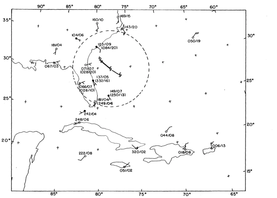
cases will be presented and discussed here. In Figure 11 there are six storm influenced stations. All six winds are modified rather effectively, and a good specification results
from the analysis. Now if Tampa (066/07) or Jacksonville (071/07) had been chosen as predicting stations, the specifi-cation would not have been so good. But for the 50 case sample, such a fortuitous choice of predictors is balanced by choices that were not so fortunate.
In Figure 12, the layer-mean winds within 300 nm of the storm center are all modified to south-southeasterly. Both the speed and direction of the storm center are well specified, despite a dearth of observations south of the storm. Generally, the farther north a tropical storm progressed, the better the specifications became, in the Gulf and in the Atlantic.
Figures 13 and 14 again show the effectiveness of the modifi-cation scheme. A strong southwesterly flow is exhibited by the uninfluenced stations along the middle Atlantic coast. This strong flow is transferred to the influenced stations,
and specifications in this region were nearly always quite good. Although the magnitudes of the errors for these cases were some-times larger than average, the percentage errors were always very small.
A J*
35*
300
250
200
Fig. 13 -- Initial mean layer winds for hurricane Helene, September 27, 1958, 1200 GMT. Notation same as in Fig. 5 a).
51.
Fig. 14 -- Initial mean layer winds for hurricane Helene, September 28, 1958, 0000 GMT. Notation same as in Fig. 5 a).
The synoptic cases with the worst velocity specifications were often located in the Caribbean Island area. The winds at the lower latitude stations were usually weaker than those at mid-latitudes. Even more important, the winds were not nearly as uniform. Thus, the residual winds and the resultant velocity specification did not seem as accurate here. In Figure 15, a very poor velocity specification comes out of the analysis. The influenced stations still exhibit cyclonic
circulation, as do the nearest uninfluenced rawinsonde obser-vations at Jacksonville (088/07), Grand Cayman Island (250/07) and Guantanamo, Cuba (173/08). This particular case seems to be a combination of several error sources. First of all, the
low latitude location makes prediction more difficult. Second, not enough storm circulation has been removed. Also, 300 nm was not a particularly good choice for the maximum storm influ-ence distance. And finally, since Miami (055/14) was about 100 nm away from the storm center, the positioning of the storm
center was still quite crucial. In fact, with the Miami obser-vation ignored, the specification direction would be improved
substantially.
Now, for the cases presented thus far, the large-scale flow has been rather uniform, and the storm track has been
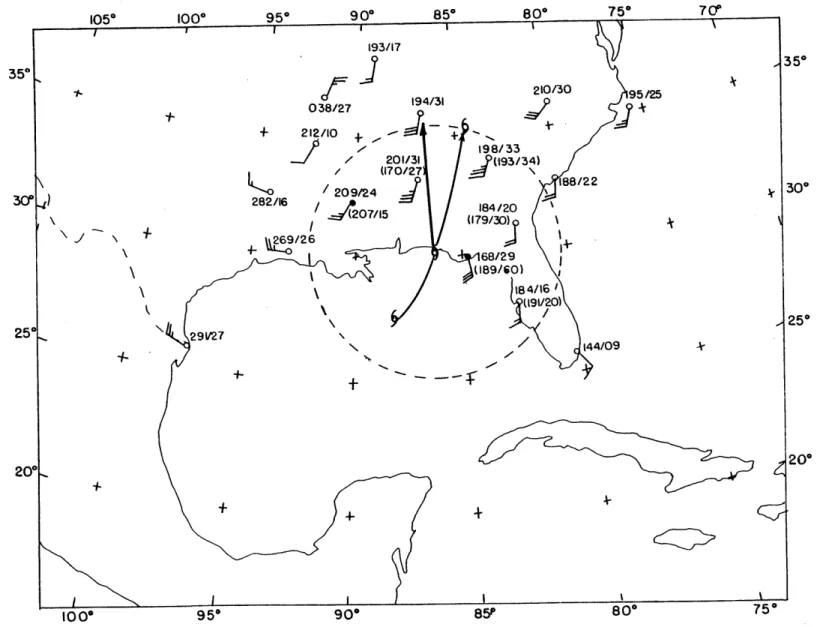
steady. This objective procedure also showed excellent speci-fications for tropical storm Delia, 1973. This especially interesting storm performed a loop along the Texas Gulf Coast and then moved inland. Operational SANBAR forecasts (based on
53.
Fig. 15 -- Initial mean layer winds for hurricane Donna, September 10, 1960, 0000 GMT. Notation same as in Fig. 5 a).
storm-track vector) were not able to predict the future storm movement successfully. But this new procedure (which uses the numerous observations within the influence distance) showed excellent specification of the track velocity. In Figure 16 a) the composite storm track and the individual specifications are shown, while in 16 b) the specifications are grouped together to show the counterclockwise change in the specification as the storm looped.
The individual cases which follow (Figures 17 a)-e)) are highlighted by the interaction of Delia with a larger cyclone, denoted by the heavy block letter. The position of the larger cyclone was determined by the lines shown, which separate north residual wind from south, and east from west. As Delia and the larger cyclone circle about each other, the looping motion of Delia seems accountable as a barotropic process.
55. Figure 16 a)
Velocity specifications for hurricane Delia, September 4-6, 1973
4- -I-I\ 6+ "" 12Z \ 5' 00Z 5 12 4 122 00oo Figure 16 b)
Compilation of velocity specifications for hurricane Delia
6 002
4 12" 6 A 12
Figure 17 a) 00 o 'lrr """ (D I-4" Z 0 0 o 00 0C~ 0' 0: 0I zo 0& 300 200
1.150 1100 1050 1000 950 900Q 85 800 750 I I I I I \ + -+ + 350 , 350 052/19 139/10 94/20 + + 158/23 + 300 - 5/18 / U52/25) 164/25 30 % 354/36 162/09 S174/20 \ (160/28) 167/19 342 29 9/13 + 296/19f + u 20" v 0 - 200 + + 290/0 8 + 105 100 950 9-00 ° 850 Figure 17 d)
61.
DISCUSSION AND CONCLUSIONS
The ultimate concern of this study was to improve
operational predictions of tropical storm tracks. The focal point was the barotropic filtered model SANBAR, currently in use at NHC. This model performs competitively with the other objective models, despite its neglect of any rawinsonde obser-vations made within 300 nm of the storm center. We felt that a possible way of improving performance was to somehow make effective use of these storm-influenced wind observations.
The first thing needed was a method for separating the vector storm contribution from the layer-mean observed winds. We subtracted 8,000 different storm wind profiles from the observed wind pattern, and the residual pattern which seemed "smoothest" was then used in the remaining analysis. In this manner, we could minimize the occurrence of unreasonable
looking residual large-scale winds. Moreover, the observa-tions themselves were used to determine which residual pattern was "smoothest".
Next, the values of the residual wind were used to provide a specification of the storm track velocity at the time of the observations. The specification was determined by stepwise screening regression, given the residual winds at each observing station. Then a comparison was made between this specified track velocity and an estimate of the actual initial velocity. For our fifty case sample, the mean
mean magnitude of the vector difference was 4.2 knots.
Finally, the regression-specified track velocity was used as a 12-hour extrapolation forecast, and the average position error was 55 nm.
Various factors were then considered to see how they affected the accuracy of the specification. The number of observations within the influence region of the storm seemed to be of minimal importance, while the distance to the nearest observing station was extremely important. In the end,
observations within 85 nm of the storm center had to be
neglected, because they were overly sensitive to the position-ing of the storm center, which can only be roughly estimated for real-time forecasts. On the basis of our results, obser-vations seem most informative when located about 100 nm from the storm center. Better specifications should also result when there is uniform station coverage around the storm center, due to a cancellation of errors.
We recommend that this new procedure be incorporated in the SANBAR analysis for use whenever sufficient rawinsonde data
is available in the vicinity of the storm. All our cases involved at least two such rawinsonde observations. This procedure, in which the variability of storm structure is recognized and the observations determine some parameters of the storm circulation itself, appears capable of specifying the initial storm-track velocity about as well as present
subjective practise. Its primary potential advantage is that the large-scale flow in the storm-influenced region is not
63.
constrained to be uniform. It should prove to be especially. useful when erratic tracks occur close to landfall.
BIBLIOGRAPHY
Ahn, C.S., 1967: Numerical prediction of hurricane movement. MS Thesis, Massachusetts Institute of Technology.
Dunn, G.E., 1961: The hurricane season of 1960. Monthly Weather Review, 89, 99-108.
Dunn, G.E. and Staff, 1959: The hurricane season of 1959. Monthly Weather Review, 87, 441-450.
Dunn, G.E. and Staff, 1964: The hurricane season of 1963. Monthly Weather Review, 92, 128-138.
Gaertner, J.P., 1973: Investigation of forecast errors of
the SANBAR hurricane track model. MS Thesis, Massachusetts Institute of Technology.
Herbert, P.J., 1976: Atlantic hurricane season of 1975. Monthly Weather Review, 104, 453-465.
Herbert, P.J. and N.L. Frank, 1974: Atlantic hurricane season of 1973. Monthly Weather Review, 102, 280-289.
Hope, J.R., 1975: Atlantic hurricane season of 1974. Monthly Weather Review, 103, 285-293.
Jordan, E.S., 1952: An observational study of the upper-wind circulation around tropical storms. Journal of Meteorology, 9, 340-346.
King, G.W., 1966: On the numerical prediction of hurricane trajectories. MS Thesis, Massachusetts Institute of Technology.
Miami Weather Bureau Office, 1958: The hurricane season of 1958. Monthly Weather Review, 86, 477-485.
Panofsky, H.A. and G.W. Brier, 1958: Some Applications of Statistics to Meteorology. The Pennsylvania State University, University Park, Pennsylvania, 224 pp.
Pike, A.C., 1972: Improved barotropic hurricane track predic-tion by adjustment of the initial wind field. NOAA
Technical Memorandum NWS SR-66.
Riehl, H., W.H. Haggard, and R.W. Sanborn, 1956: On the prediction of 24-hour hurricane motion. Journal of Meteorology, 13, 415-420.
Sanders, F., 1970: Dynamic forecasting of tropical storm
tracks. Transactions of the New York Academy of Sciences, 32, 495-508.
65.
Sanders, F. and R.W. Burpee, 1968: Experiments in barotropic hurricane forecasting. Journal of Applied Meteorology,
7, 313-323.
Sanders, F., A.C. Pike, and J.P. Gaertner, 1975: A barotropic model for operational prediction of tracks of tropical
storms. Journal of Applied Meteorology, 14, 265-280. Sanders, F. and N.J. Gordon, 1976: A study of forecast errors
in an operational model for predicting paths of tropical storms. Scientific Report No. 2, Contract F19628-75-C-0059 AFGL-TR-77-0079.
Simpson, R.H., A.L. Sugg, and Staff, 1970: The Atlantic hurricane season of 1969. Monthly Weather Review, 98, 293-306.
Williams, F.R., 1972: Applications of the SANBAR hurricane track forecast model. MS Thesis, Massachusetts Institute of Technology.