HAL Id: hal-02413511
https://hal.uca.fr/hal-02413511
Submitted on 18 Nov 2020
HAL is a multi-disciplinary open access
archive for the deposit and dissemination of
sci-entific research documents, whether they are
pub-lished or not. The documents may come from
teaching and research institutions in France or
abroad, or from public or private research centers.
L’archive ouverte pluridisciplinaire HAL, est
destinée au dépôt et à la diffusion de documents
scientifiques de niveau recherche, publiés ou non,
émanant des établissements d’enseignement et de
recherche français ou étrangers, des laboratoires
publics ou privés.
Anak Krakatau flank-collapse eruption
Mathieu Gouhier, Raphael Paris
To cite this version:
Mathieu Gouhier, Raphael Paris. SO2 and tephra emissions during the December 22, 2018 Anak
Krakatau flank-collapse eruption. Volcanica, Presses Universitaires de Strasbourg, 2019, 2 (2),
pp.91-103. �10.30909/vol.02.02.91103�. �hal-02413511�
O
V L O
V
NI O
V
RESEARCH ARTICLE
V L O
O
V
NI O
V
RESEARCH ARTICLE
V L O
O
V
NI O
V
RESEARCH ARTICLE
SO
2
and tephra emissions during the December 22, 2018
Anak Krakatau flank-collapse eruption
Mathieu Gouhier
*, Raphaël Paris
Université Clermont Auvergne, CNRS, IRD, OPGC, Laboratoire Magmas et Volcans, F-63000 Clermont-Ferrand, France.
Abstract
On December 22, 2018 the south-western flank of Anak Krakatau collapsed into the sea, removing 93.8 × 10⁶m3 of subaerial lavas, and generated a tsunami. Synchronously with the collapse, a large volcanic plume of SO2and ash (14–15 km in height) has formed, marking the onset of a paroxysmal eruption lasting from December 22, 2018 to January 06, 2019. From remote sensing analysis, we show that the eruption can be divided into three main phases. Phase I and II show both tephra and gas emissions while phase III is mostly degassing. The total amount of SO2injected in the atmosphere is 173±52 kt, while the minimum bulk magma volume emplaced, estimated from a topographic reconstruction, is ∼45 × 106m3. This value compares well with a petrologic-based estimate of 56.4 × 10⁶m3, making the existence of external sulphur sources and sinks quite unlikely. The ice-rich ash plume formation shows that a strong sea-water/magma interaction was responsible for the phreatomagmatic activity throughout the eruption. However, we distinguish a first Vulcanian blast-derived eruption (lasting 40 min) just after the collapse having a Mass Eruption Rate (MER) of 9 × 10⁵kg s−1, followed by a sustained lower-intensity eruption resulting in ash emissions over hours (MER = 5 × 10⁵ kg s−1). From December 23, daytime photos show typical Surtseyan activity.
Résumé
Le 22 décembre 2018, le flanc sud-ouest de l’Anak Krakatau s’est effondré dans la mer, arrachant 93.8 × 10⁶m3
de roches volcaniques à l’édifice préexistant et provoquant ainsi un tsunami. Parallèlement à l’effondrement, un important panache volcanique de SO2et de cendres (14 à 15 km de haut) s’est formé, marquant le début d’une éruption paroxysmale qui s’est déroulée du 22 décembre 2018 au 06 janvier 2019. À partir de l’analyse des données de télédétection spatiale, on montre que l’éruption peut être divisée en trois phases principales. Les phases I et II présentent à la fois des émissions de téphra et de gaz, tandis que la phase III est essentiellement associée à du dégazage. La quantité totale de SO2injectée dans l’atmosphère est de 173±52 kt, tandis que le volume minimal de magma mis en place, estimé par reconstruction topographique, est de ∼45 × 106m3. Cette valeur est comparable à l’estimation basée sur la méthode pétrologique (56,4 × 10⁶m3), ce qui écarte l’hypothèse de sources (ou de puits) additionnelles de soufre dans le budget global de SO2émis en surface. La formation d’un panache de cendres riche en glace démontre une forte interaction entre l’eau de mer et le magma. Ce mécanisme est responsable de l’activité phréatomagmatique tout au long de l’éruption. Dans le détail, nous identifions une première phase Vulcanienne initiée par une explosion latérale de courte durée (∼40 min) juste après l’effondrement, avec un flux de masse éruptif (MER) de 9 × 10⁵kg s−1. Juste après, l’éruption montre une colonne plus soutenue mais de faible intensité entraînant des émissions de cendres sur plusieurs heures (MER = 5 × 10⁵ kg s−1). À partir du 23 décembre, de nombreuses photos attestent d’une activité typiquement Surtseyenne.
Keywords: SO2 degassing; Volcanic ash; Flank Collapse; Anak Krakatau;
1
Introduction
Anak Krakatau is a volcanic island located in the Sunda Strait (Indonesia), which emerged in 1927 on the rim of the submarine caldera that was formed during the 1883 eruption of Krakatau. On December 22, 2018 at 13:50 UTC the south-western flank of Anak Krakatau volcano (Indonesia) collapsed to the sea and generated a tsunami in the Sunda Strait [ESDM 2018]. Tsunami waves devastated the coasts of Java and Sumatra, killing 431 people and damaging thousands of houses and boats, as reported by BNPB (Badan
Na-*Corresponding author:[email protected]
sional Penanggulangan Bencana: https://bnpb.go.id). Although this scenario of collapse-generated tsunami had been predicted and simulated by Giachetti et al. [2012], the disaster could not be prevented and be-came one of the deadliest volcanic eruptions of the last decades. After 16 months of quiescence, Anak Krakatau’s activity resumed in June 2018 in the form of both explosive and effusive eruptions. The collapse followed a period of 6 months of volcanic activity and rapid growth of the volcanic cone, as evidenced by satellite images captured in 2018 (MODIS, Sentinel constellation, PlanetScope, etc.), reports on seismic activity by PVMBG (Pusat Vulkanologi dan Mitigasi
Bencana Geologi: https://magma.vsi.esdm.go.id) and photographs available on the web (e.g.
http://www.oysteinlundandersen.com). Immedi-ately after the collapse, Anak Krakatau experienced a long-lived eruption, from December 22, 2018 to January 06, 2019, of intense pheatomagmatic activity showing a series of strong volcanic explosions. The amount of SO2 and tephra released as well as the
dynamics of the eruption contrast with the moderate activity of the last 6 months.
In this study, we focus on the mass budget of ma-terial emplaced during the post-collapse eruption. In particular, we provide a time-averaged estimation of bulk magma volume emitted from topographic recon-struction techniques using remote sensing data. Then, from the processing of daily UV satellite-based data, we provide a detailed analysis of SO2emissions. Estimates of mass fluxes of outgassed SO2are particularly
impor-tant as they provide information on the eruptive activ-ity at the surface [e.g.Carn and Prata 2010], the shallow plumbing system [e.g. Gauthier et al. 2016], and the magma ascent dynamics [e.g.Allard 1997]. The combi-nation of SO2released at the surface with sulphur
con-centration in Melt Inclusions (MI) can yield key infor-mation on possible external sulphur sources and sinks at shallow levels [e.g.Edmonds et al. 2003;Sigmarsson et al. 2013]. Finally, estimation of ash plume concentra-tion and altitude are obtained from IR satellite-based data [Prata 1989a;Wen and Rose 1994]. These param-eters are critical as they allow indirect assessment of the Mass Eruption Rates (MER) of tephra emitted at the source vent from empirical formulations [Sparks et al. 1997;Mastin et al. 2009] or statistical modelling [Gouhier et al. 2019]. Also, the evaluation of airborne ash mass fluxes (Qa) is essential in understanding the
dynamics of particle transport and dispersion, and bet-ter constraining sedimentation mechanisms [e.g.Carey and Sigurdsson 1982;Durant and Rose 2009; Carazzo and Jellinek 2013;Manzella et al. 2015].
2
Data and Methods
2.1 Pre- and post-collapse topography of the island Pre-collapse topography of Anak Island was de-rived from the DEMNAS (national digital elevation model of Indonesia, spatial resolution of 0.27 arc-second using the vertical datum EGM2008, provided by the Indonesian Geospatial Agency, and available at http://tides.big.go.id/DEMNAS/index.html). This DEM was built from InSAR, TerraSAR-X and ALOS-PALSAR data collected from 2000 to 2013. The orig-inal DEMNAS raster file was converted into a shape-file (contour lines) that was modified in order to in-clude the latest growth of the edifice, as seen on photographs taken in August and November 2018 (http://www.oysteinlundandersen.com), and satellite
images (e.g. Sentinel-2 image captured on 30 Septem-ber 2018, and PlanetScope image captured on 17 De-cember 2018: seeFigure A1). Pre-collapse bathymetry is fromDeplus et al. [1995].
The contour of the collapse scar was inferred from a Sentinel-1A image captured ∼8:30 hours after the collapse (22/12/2018 at 22:33:44 UTC) and pho-tographs taken by Susi Air flight crew the day af-ter (23/12/2018). There is no data available on post-collapse bathymetry and the submarine extent of the collapse scar.
Intense phreatomagmatic activity rising from the sea surface inside the scar produced a significant vol-ume of pyroclastic deposits, thus reshaping the land in a few days. Post-collapse evolution of the is-land’s perimeter could be traced from different satellite images captured between 22 December 2018 and 31 March 2019 (Sentinel-1-A/B, Sentinel-2, TerraSAR-X, PlanetScope). The topography of the island on January 10, 2019 was reconstructed using drone photogram-metry (drone footage by James Reynolds, Earth Uncut TV:https:/www.earthuncut.tv). Images were processed using Agisoft Photoscan Pro (https:/www.agisoft.com). Using a Structure-from-Motion workflow, the software (1) detected matching points and aligned all images, (2) constructed a dense point cloud from depth informa-tion of each aligned image, (3) calculated a triangulated mesh, (4) and built a digital elevation model after 11 ground control points (GCP) were implemented (from a Sentinel 2 image captured on 13 January 2019). The resulting DEM has a resolution of 2 m per pixel, but its completeness is unequal from one flank to another due to the spatial distribution of the drone images. In order to locally complete the model, additional points were extrapolated from different aerial and ground photographs available on the web (e.g. BNPB survey of 13 January 2019). Although the method might be further optimised in the future by better parameteris-ing the drone survey and implementparameteris-ing GNSS GCPs, it provides a rough estimate of the new topography of the island less than 20 days after the collapse.
2.2 Satellite-based SO2retrieval
Volcanic sulphur dioxide emissions (SO2) have long
been characterized from satellite-based UV sensors [e.g. Schneider et al. 1999; Carn et al. 2003; Yang et al. 2007]. A variety of sensors (IR/UV) and plat-forms (GEO/LEO) now exists and allows a detailed de-scription and quantification of SO2mass loading
dur-ing eruptive events. Firstly, in this study we used the combination of Aura/OMI data (∼90 %) and Suomi-NPP/OMPS data (∼10 %) in order to capture the long-term (195 days, between 10/06/2018 and 22/12/2018) SO2 emission pattern before the Anak flank collapse. The combination of both sensors allowed us to avoid data gaps in the time series. Data were acquired from NASA’s EarthData (https://search.earthdata.nasa.gov/)
Volcanica 2(2): 91 – 103. doi: 10.30909/vol.02.02.91103
Figure 1: SO2mass fluxes retrieval. [A] Run example of HYSPLIT forward trajectory on 22/12/2018 at 14:00UTC
showing the best trajectory (blue line) drifting in the south-westward direction at an altitude of 14 km AGL with an average velocity of 15m/s. [B] Tropomi/Sentinel-5 image on 23/12/2018 showing the SO2plume slant column
densities (g/m2) at UTLS level (Upper Troposphere Lower Stratosphere). Also, the boxes used for the assessment of e-folding time correction are represented.
using the “Total Column 1-orbit L2 Swath 13x24 km V003 (OMSO2)” product for OMI/Aura Sulphur Diox-ide, and the “Total Column 1-Orbit L2 Swath 50x50 km” product for OMPS/NPP Sulphur Dioxide. Then, in order to better assess the eruption dynamics and provide a refined evaluation of SO2 emissions, we
processed data from the TROPOMI sensor onboard the Sentinel-5 platform. We used the Offline timeli-ness L2_SO2 data products from ESA-Copernicus Pre-Operation Data-Hub (https://scihub.copernicus.eu/). For estimating SO2 emissions before the flank col-lapse, we used the middle troposphere elevation model (TRM, 5–10 km) as most emissions were in-jected to low/moderate altitudes. By contrast, for the 22/12/2018 eruption we used the 15-km elevation model (UTLS) from TROPOMI Slant Column Densities (SCD).
The calculation of the mass loadings or/and mass fluxes have already been widely described in the litera-ture (see, e.g.Theys et al. [2013], for a review). A vari-ety of methods associated with satellite-based data ex-ists, such as the Traverse, Box, Delta-M or Inverse meth-ods. They all have their specificity and domain of ap-plication. For our study we used the box method [Lopez et al. 2013] which allows mass fluxes to be determined from the estimation of SO2total columns divided by the duration of emission. In our case the travel time of the plume, which is directly related to the wind velocity, has been estimated from HYSPLIT trajectory model (
Fig-ure 1A). However, for large plumes extending over sev-eral hundreds of kilometres the SO2loss term, mainly
due to the plume dilution and SO2oxidation into
sul-phuric acid, is not negligible. In the case of a signifi-cant interaction between the eruption column and the sea water, as it is most likely here, it is possible that a significant amount of SO2is rapidly lost to scrubbing.
Finally, note that the cloud cover may have sometimes obscured and prevented SO2detection and quantifica-tion. This is true in particular during the pre-collapse, as weak emissions are typically of low altitude. We thus provide here a minimum estimate during this period. During the post-collapse paroxysm, a plume column al-titude of ∼14 km makes the SO2estimation much more
reliable, as few or no water cloud obscuration should occur. Overall, the budget of SO2from a satellite
im-age is thus a balance between SO2emissions and losses.
This problem can be modelled from the solution of the mass conservation law:
∂c
∂t = −kc (1)
where the loss term is simply assessed by the applica-tion of an age dependent correcapplica-tion et/τ, where τ (i.e.
1/k) is known as the SO2e-folding time. This parame-ter is difficult to assess and can be highly variable from one eruption to another [Rodrıguez et al. 2008;Krotkov et al. 2010;McCormick et al. 2014;Beirle et al. 2014]. Indeed it actually depends on weather and atmospheric
conditions into which the eruption injects the gas. It will also greatly depend on plume altitude as higher at-mospheric layers are much more dryer than lower ones, hence having longer lifetimes. Thus, we have calculated the SO2e-folding time for this eruption (Figure 1B)
us-ing a sequence of small boxes of variable sizes but en-closing the full width of the plume (i.e. crosswind). Under the simplifying, but mandatory, assumption that the flux is constant within the current plume formation, we calculate an e-folding time of τ ∼30.4 hours. 2.3 Airborne ash retrieval from TIR
Satellite-based Thermal infrared (TIR) sensors are very useful for characterizing volcanic ash. In the TIR re-gion (i.e. 7–14 µm), we can distinguish silicate particles (e.g. volcanic ash) from other aerosols (e.g. ice crys-tals or H2SO4) using a two-channel difference model
based upon the absorption feature between the 11- and 12 µm) wavelengths [Prata 1989b;Wen and Rose 1994;
Watson et al. 2004]. It was shown that the differences
between the at-sensor “Planck” brightness temperature (referred to as BTD) observed in these two channels are negative (−∆T ) for ash and positive (+∆T ) for ice (Figure 2A). Building on earlier work [Prata 1989b],
Wen and Rose [1994] developed a forward retrieval model that quantifies the effective radius (re) and
opti-cal depth (τc) from the extinction efficiency factor (Qext)
calculated using Mie theory. This allows theoretical look-up-tables (LUT) to be generated for sets of vari-ations of both re and τc as a function of the
bright-ness temperature. Thus, from inverse procedures, one can retrieve a value of re and τc for any given
bright-ness temperature pair (seePrata and Grant [2001]and
Watson et al. [2004]for details), hence leading to the estimation of the vertically-integrated ash concentra-tion (g m−2
) of a volcanic cloud. However, satellite re-trievals are affected by several factors such as the sur-face characteristics (i.e. temperature and emissivity), plume geometry (i.e. altitude and thickness), ash op-tical properties and water vapour. These factors pro-duce an uncertainty of ∼40 % and ∼30 % respectively associated with the total mass retrieval and the effec-tive radius [Corradini et al. 2008]. Another source of uncertainty is related to the presence of large parti-cles (typically for ref f > 6 µm), possibly existing in
fine ash clouds, which cannot be retrieved using the Mie theory because Qext does not vary strongly for
ref f > λ/2[Guéhenneux et al. 2015; Stevenson et al.
2015]. Overall, effects related to both misdetection
is-sues (i.e. BTD) and the presence of coarse ash parti-cles in the cloud may lead to a mass underestimation of about 50 % [Stevenson et al. 2015]. Also, we can pro-vide the ash cloud top altitude (Figure 2B) using a com-bination of the cloud surface brightness temperature at 11.2 µm (H8 TIR waveband #02) and temperature profiles from atmospheric soundings. This technique refers to the Cloud Top Temperature (CTT) method and
is only possible in the troposphere, where the temper-ature profile is monotonic [e.g.Prata and Grant 2001]. Here we used TIR data from Himawari-8 (H8) geosta-tionary satellite operated by the Japan Meteorological Agency (JMA) which provides images every 10 minutes at a spatial resolution of ∼ 2 × 2 km at nadir. Data were collected through the Centre for Environmental Remote Sensing (CEReS) using gridded data products from full-disc observation mode ( http://www.cr.chiba-u.jp/english/database.html). The very high time res-olution of TIR images used allows us to catch the dy-namics of the ash plume at the initial stage, during and after the collapse (i.e. on 22/12/2018 at 13:50 UTC). In Figure 2B, we show as an example one image of the plume brightness temperature at 11.2 µm (H8 TIR waveband #02) that allows us to determine the plume top altitude between 14 and 15 km (a.s.l.) by comparing with local and synchronous atmospheric temperature profiles. For this study, temperature profiles were ob-tained using atmospheric sounding data of the station 96789 WIII-Jakarta (accessible from the Department of Atmospheric Science of the University of Wyoming:
http://weather.uwyo.edu/upperair/sounding.html).
3
Results
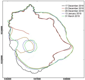
3.1 Volume of post-collapse pyroclastic deposits The flank collapse removed 93.8 × 10⁶ m3 (Figure 3) of subaerial lavas from the western flank of the vol-cano. This volume corresponds to a minimum value, as the submarine extent of the collapse remains unknown. However, the collapse scar was rapidly filled by post-collapse pyroclastic deposits (Figures 3 and A1). On early January imagery, the collapse headwalls are al-ready buried by new pyroclastic deposits, and details of the pre-collapse topography such as 10 m-high coastal cliffs are no longer visible (e.g. south-eastern coast of the island). Vegetation on Panjang Island, located 2.5 km east of Anak Island, was severely damaged by ash fallout and surges, as evidenced by drone footage and Sentinel-2 images captured on January 8 and March 31, 2019 (Figure A2).
Reconstruction of post-collapse topography at two different time steps (22/12/2018: just after the col-lapse; and 10/01/2019: 19 days after the collapse) con-firms that an important volume of juvenile tephra was deposited by ash fallouts and pyroclastic density cur-rents after the collapse (Figure 3). On Anak Island, post-collapse pyroclastic deposits represent a volume of 29.4 × 10⁶m3. There is no information available on
the volume of submarine pyroclastic deposits. Analy-sis of shoreline evolution from 17 December 2018 to 31 March 2019 (Figure 4) shows a clear increase of the sur-face area of the island, with a shoreline progradation of up to 270 m on the eastern coast of the island. This progradation corresponds to a volume of 8.3 × 10⁶m3
Volcanica 2(2): 91 – 103. doi: 10.30909/vol.02.02.91103
Figure 2: Ash plume characterization. [A] Brightness Temperature Difference (BTD) of band L02 (11.2 µm) and L03 (12.4 µm) from Himawari-8 satellite, showing the ash plume at 14:30 UTC on 22/12/2018. [B] Brightness Temperature (in Kelvin) at 11.2 µm used for the plume height determination (see text for details).
of submarine pyroclastic deposits, which is probably a minimum value compared to the total volume of pyro-clastic deposits that were emplaced on the sea bottom. We thus estimate that the total volume of post-collapse pyroclastic deposits, both subaerial and submarine, is larger than ∼45 × 106 m3 (>27 × 106 m3 DRE magma volume). Most of these deposits were produced in less than one week, as evidenced by satellite images cap-tured from 23 to 29 December (Figure 4). The shoreline of the island just after the collapse (23/12/2018) is sim-ilar to the pre-collapse shoreline (17/12/2018), with the exception of the area of the collapse scar. Between 29 December 2018 and 31 March 2019, the shorelines of the island did not change significantly.
3.2 SO2mass loading and magma volume
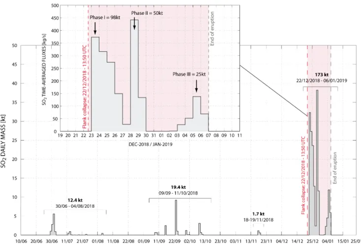
In Figure 5, we processed a time series of volcanic SO2emitted by the Anak Krakatau in the period
rang-ing from June 10, 2018 to January 15, 2019. These values represent the SO2 daily mass loading (in
kilo-tons). They have been estimated from the calculation of time-averaged mass fluxes (in kg s−1,Figure 5) based on a time/distance window corresponding to the plume footprint for each image of the sequence, and referred to as the box method [Lopez et al. 2013]. It includes the e-folding time correction (τ) estimated at ∼30.4 hours, and accounting for the SO2 loss term (Figure 1). SO2
emitted before the collapse (10/06/2018–22/12/2018) has been calculated using a combination of OMI/Aura and OMPS/Suomi satellite-based data in order to avoid data gaps. SO2 emitted during the 22/12/2018 col-lapse and subsequent explosions has been calculated from TROPOMI/Sentinel-5 satellite-based data, hence allowing a refined determination of the SO2mass
load-ing (see method section for details). Indeed, since early
June, three main periods have been identified before the collapse. The first one spanning 30/06–04/08/2018 is associated with weak emissions of SO2 yielding a
total of 12.4 kt. A second one has been identified from 09/09 to 11/10/2018 with significantly higher SO2 emission, and totalling 19.4 kt. Then, except a
short pulse on 18–19/11/2018, no significant SO2
emis-sions have been detected until the major flank collapse on 22/12/2018. The pre-collapse emissions were typ-ically of moderate altitude (low-middle troposphere) and associated with weak to mild explosive activity (i.e. mainly Strombolian). Finally, post-collapse volcanic ac-tivity emitted 173±52 kt of SO2in 11 days (see inset in
Figure 5). Errors on SO2 retrieval are difficult to
as-sess accurately, but they can be relatively large. Indeed,
Lee et al. [2009]have estimated in a study dedicated to validation and error analysis that the total uncertainty in the retrieval of SO2 columns from similar
instru-ments is in the range of 20–40 %. The flank collapse occurred on 22/12/2018 around 13:50 UTC. This has been confirmed by thermal infrared data recorded by Himawari-8 geostationary satellite (Figure 6), allowing the full-disc image acquisition every 10 minutes. By contrast, the TROPOMI/Sentinel-5 platform provides one image/day with an acquisition time above this re-gion lying between 06:00 and 07:00 UTC. Thus, the first peak reaching 32.3 kt of SO2is detected ∼16 hours
after the collapse (23/12/2018), hence corresponding to a time-averaged mass flux of 373.4 kg s−1(Figure 5). The plume had already drifted south-westward ∼1670 km away from the source vent. Processing of HYS-PLIT trajectories (Figure 1) has allowed the determi-nation of the SO2 plume altitude at ∼14 km a.s.l.,
which is in agreement with the ash plume altitude (14–15 km) determined from Himawari-8 TIR wave-bands using the Cloud Temperature Method (CTT)
and atmospheric soundings (Figure 2). Such altitudes confirm a very explosive eruption, probably caused by the rapid and massive decompression of the shal-low magma system due to the initial flank collapse.
Figure 3: [Left] Evolution of the topography of Anak Krakatau volcano following the 22 December flank col-lapse. [A] 17 December 2018: lava flows emplaced since June 2018 (yellow arrows) are located on the south-western flank (southwest of the yellow dotted line). [B] 22 December 2018: the western flank of the active cone is truncated by a > 93.8 × 10⁶ m3 col-lapse (black arrows). [C] 10 January 2019: rapid island growth, with > 45 × 106m3of new tephra deposited on land and offshore (mostly between 22 and 29 Decem-ber 2018, seeFigure 5) by ash fallout and pyroclastic density currents (red arrows). UTM coordinates (zone 48S).
From the SO2 mass flux time series (Figure 5), we
can discretize 3 different phases: the first one, in-cluding the initial flank collapse, starts on 22/12/2018 and spans 5 days of intense activity (Phase I: 22-27/12/2018), with emissions totalling 98 kt of SO2. During the first phase, SO2 mass fluxes gradually de-crease from 373.4 to 27.5 kg s−1
and resumed in a strong pulse of SO2 recorded on 28/12 with fluxes peaking at 442 kg s−1. This new pulse signals the onset of
the second phase, lasting only 2 days (phase II: 28-29/12/2018), and totalling 50 kt of SO2. Finally,
af-ter 4 days of pseudo-quiescence, the third phase be-gins on 3 January 2019 showing lower mass fluxes (phase III: 03-06/01/2019) and with emissions totalling 25 kt of SO2. Since then, no new emissions occured,
at least within the next 2 months. Phases 2 and 3 were clearly observed on live seismograms provided
Figure 4: Shoreline evolution of Anak Island between December 2018 and March 2019 (23 December 2018 Sentinel-1A; 29 December 2018, 13 January 2019, and 31 March 2019 Sentinel-2; 17 December 2018 Plan-etscope data).
Volcanica 2(2): 91 – 103. doi: 10.30909/vol.02.02.91103
Figure 5: Daily mass of SO2calculated from a combination of OMI/Aura and Suomi-NPP/OMPS satellite before
the collapse (10/06/2018–22/12/2018) and using Tropomi/Sentinel-5 satellite data after the collapse. Also, we provide SO2time-averaged mass fluxes (in kg s
−1
) for the post-collapse eruption (top panel) clearly showing the 3 different phases of post-collapse degassing.
by PVMBG (https://magma.vsi.esdm.go.id). The three different phases following the collapse total together about 173 ±52 kt of SO2injected in the atmosphere.
From SO2degassed and measured at the surface, we
can retrieve the amount of related magma involved (erupted or not) using petrologic methods [Devine et al. 1984]. For this purpose, we used the sulphur con-centration of basaltic andesites reported for the 1883 Krakatau eruption [Mandeville et al. 1996;Fiege et al. 2014; Bani et al. 2015] as a reference. The average sulphur concentration in melt inclusions was found to be ∼900 ppm (SMI) while the average dissolved
sul-phur concentration in matrix glass does not exceed 10 % (SMG): Calculating the concentration difference
(SMI−SMG), yields an outgassed sulphur concentration
of ∼810 ppm. Then, from the outgassed sulphur con-centration and the airborne SO2mass loading we can
calculate the volume of parental magma, following: V olm=
MSO2×100
αρm(SMI−SMG)
(2) where MSO2 is the total mass of sulphur dioxide
mea-sured by satellite (in kg), α is the molar mass ratio
SO2/S and ρmis the magma density taken as 2700 km3
[Bani et al. 2015]. We have thus estimated a DRE parental magma volume of 39.5× 10⁶ m3. Using a bulk porosity of ∼40 %, accounting for both erupted tephra and lava flows [Bani et al. 2015], we obtain a bulk magma volume of 65.9 × 10⁶m3(i.e. ∼0.066 km3). By comparison, the minimum bulk volume of post-collapse pyroclastic deposits emplaced after the col-lapse in the proximal field (on and around Anak Island) is around ∼ 45 × 106 m3 (Figure 3). From Sentinel-2 data (Figure 4) we observe that the very large major-ity of this volume was already emplaced on 29 Decem-ber 2018 (i.e. 7 days only after the collapse). There-fore, this bulk tephra volume can be compared with the sulphur-derived magma volume over phase I and II, solely. As a result, both volumes are quite consis-tent with values of 45 × 106 m3 and 56.4 × 10⁶ m3 for
the topographic and petrologic methods, respectively. The 20 % difference can reasonably be explained by the significant amount of tephra fallouts and PDCs lost in the sea and not visible from the topographic anal-ysis. Also, uncertainties on input parameters used in the petrologic method combined with SO2retrieval
er-rors may account for this difference. The agreement between both estimations indicates that the amount of magma extruded as tephra during phase I and II is in accordance with the amount of SO2emitted and
mea-sured in the atmosphere. This makes the existence of external sulphur sources and sinks (e.g. sulphide glob-ules, hydrothermal system storage) quite unlikely, at least during the first two phases (i.e. 22–29/12). In-deed, during the third phase the emission of tephra is limited, as suggested by satellite data of Anak Krakatau island contours, which do not extend after the 29/12 (Figure 4). Although some limited ash plumes remain sporadically visible, e.g. on 05/01, they cannot explain the 25 kt of SO2injected (i.e. equivalent to 9.5 × 10⁶ m3of bulk magma for 810 ppm of outgassed sulphur) during phase III. Therefore, the SO2 emissions during
Phase III are likely mostly associated with degassing of magma in the shallow system now exposed by the flank collapse.
As most of the erupted material was in the form of tephra, it is interesting to calculate a MER averaged over the entire eruption duration. For this purpose, we take the DRE magma volume estimated from the topographic reconstruction before and after the erup-tion (Figure 3), which gives a minimum estimate of removed material, and the duration of phase I + II (i.e. 7 days) representing the period of active tephra emissions. This yields a MER time-averaged value of 1.2 × 10⁵ kg s−1. This is comparable to the September 26, 1997 Soufrière Hills Vulcanian eruption (∼ 1.5×10⁵ kg s−1) or to the June 17, 1996 small/moderate Ruapehu eruption (∼ 1.2×10⁵kg s−1) [Gouhier et al. 2019]. Note, however, that in our case the averaged value does not account for variability of the MER possibly occurring during the 7-day averaging period.
3.3 Airborne ash mass and MER
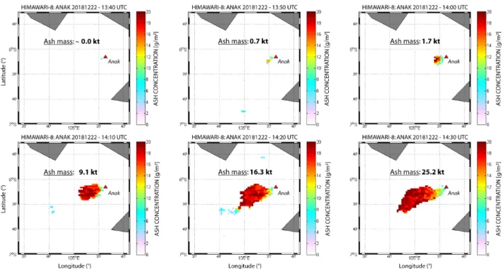
The amount of airborne ash emitted can also be es-timated from satellite-based Thermal Infra-Red (TIR) imagery provided weather conditions are favourable. For this purpose, we used data from the geostationary platform Himawari-8 providing full-disc coverage at a 10-minutes time interval (see method section for de-tails). From the improved split window technique us-ing the 3-bands methods [Guéhenneux et al. 2015], we first detected ash-bearing pixels. Then, from inversion of TIR data using radiative transfer modelling we give the ash cloud concentration (in g m−2), as displayed in
Figure 6, and the airborne ash flux Qa(in kg s
−1
). From Figure 6 we observe that ash emissions can clearly be identified as early as 13:50 UTC, forming a transient high-altitude cloud of ash, coincident with the flank collapse. This first phase of effective ash emission only lasts about 40 minutes (13:50 to 14:30 UTC) and is directly related to the collapse itself. The initial plume seems to have a strong horizontal component reaching 120 km in only one hour. This has been assessed by
tracking the evolution of the front edge of the plume over a sequence of Himawari-8 images. This strong horizontal component can possibly be explained by the rapid lateral decompression generated by the flank col-lapse oriented westward, acting as a blast-generating event. However this mechanism is not likely to be re-sponsible for plume transport on scales of over 100 km in horizontal direction. By contrast, the front edge of the plume will likely propagate downwind at a speed higher than the wind speed as the eruption cloud ex-pands [Sparks et al. 1986], which may also explain the high displacement velocity of the plume captured by satellite.
Note that the volcanic plume has a strong water-rich component (BTD 0), which is corroborated by day-time observations on 23/12 from detailed optical im-ages (e.g. Terra-MODIS), and possibly preventing an accurate estimate of the ash mass loading. Thus, for this collapse-related plume we estimated a minimum airborne ash flux of Qa∼1 × 10⁴ kg s
−1
using the mass difference method. Surprisingly, the ash plume emis-sion stopped between 14:40 and 15:30 UTC, and then resumed forming a sustained high-altitude, water-rich cloud of ash for at least 10 hours. After this point, the content of water/ice in the cloud is so large that ash-containing pixels cannot be detected. This effect is enhanced by the decrease of ash emissions with time. Thus, during the first 10 hours of the post-collapse plume, a much more vertically oriented eruption col-umn developed, still drifting in southwest direction, but at a lower velocity. Indeed, it covered only 65 km in one hour. The airborne ash flux of Qa ∼ 5 × 10³
kg s−1 estimated using the mass difference method is only half that obtained during the initial blast. How-ever, airborne ash represents only a fraction of the total amount of tephra emitted at the source vent [e.g.Rose et al. 2000; Webster et al. 2012; Gouhier et al. 2019]. Thus, in order to retrieve the total MER, one can use an empirical formulation including the plume top height [e.g.Sparks et al. 1997;Mastin et al. 2009]. But another method using both the plume height and airborne ash fluxes gives much better results [Gouhier et al. 2019], following in our case:
MER = 25.95Q0.72a H1.4 (3)
where Qa is the airborne fine ash flux in kg s
−1
and H is the top plume height (a.g.l.) in km. Using this equation, we obtain a MER of 9 × 10⁵ kg s−1 and 5 × 10⁵ kg s−1 for the collapse-related plume and the post-collapse plume, respectively (Figure 7). The eruption dynamics of both phases are quite differ-ent: the first collapse-related plume resembles a Vul-canian eruption style. The reasons for that are (i) the short duration with impulsive emissions, (ii) and the high MER compared to a moderate plume alti-tude [Walker 1981; Clarke et al. 2002]. The sec-ond phase lasts much longer showing sustained ash emissions over hours (at least) with a strong
inter-Volcanica 2(2): 91 – 103. doi: 10.30909/vol.02.02.91103
Figure 6: Airborne ash mass concentration (in g m−2
) retrieved from inversion of thermal infrared images using Himawari-8 data. These images show (i) the onset of the eruption at 13:50 UTC, i.e. synchronous with the collapse, (ii) the ash plume direction at a 10-minutes time resolution and (iii) the increase of the total ash mass loading.
Figure 7: Main parameters for the December 2018–January 2019 eruption of Anak Krakatau summarizing the budget of material emplaced after the collapse from different techniques and spanning different time scales. “kt” stands for kilotons, “Mm3” for millions of cubic meters, “MER” is Mass Eruption Rate, “Qa” is the airborne fine
action with sea water. Daytime photos taken on 23 December, for instance, show typical Surtseyan activ-ity (e.g. http://www.oysteinlundandersen.com). Fi-nally, the time-averaged MER (7-days) calculated from the total volume of proximal tephra and estimated at 1.2 × 10⁵kg s−1compares rather well with the above es-timations of MER (Figure 7). Logically, the initial MER is the much higher (∼ 10 times), although it is of short duration (40 min). Then the post-collapse MER, within the first 10 hours only, is still higher (∼ 5 times). This leads us to believe that the MER during the last 6.5 days decreased drastically and that even periods of complete quiescence in ash emissions were perhaps possible.
4
Conclusions
The December 22, 2018 collapse-related eruption of Anak Krakatau occurred after a period of 6 months of enhanced volcanic activity and marks the climac-tic phase of a new eruptive cycle. Although Anak Krakatau is one of Indonesia‘s most active volcanoes very little information on gas emissions was available [Bani et al. 2015]. The results given in this study can be analysed in a broader perspective. Indeed, the volume of the subaerial volcanic cone of Anak Krakatau, built since 1927, has been estimated by Bani et al. [2015]
during a field campaign in 2014 to be ∼ 320 × 106 m3 (equivalent annual growth rate of 3.8 × 10⁶ m3yr−1). This means that the minimum estimates of the bulk volume of tephra emplaced during the 22–29/12/2018 period (45 × 106m3 during Phase I + II) represents the equivalent of ∼ 12 years of cone growth. Also, the total amount of SO2emitted for the whole eruption duration
(173±52 kt) is significantly larger than the ∼70 kt yr−1 of SO2 recorded at Anak Krakatau in 2014 by UV
air-borne spectrometer [Bani et al. 2015]. This means that the volcanic eruption produced the equivalent of 2.5 years of passive SO2emissions in only 11 days.
Finally, this study also shows the importance of long-term and continuous monitoring (deformation, degassing, etc.) of small volcanic islands. Collapse-related eruptions are difficult to predict, and rapid re-sponse to eruptive crises is essential for hazard mitiga-tion. In this respect, the use of thermal infrared data onboard geostationary platforms is valuable, as it al-lows night and day acquisition at a time interval of 10 minutes. This is particularly important for air traffic as airborne ash may cause serious damage to aircraft potentially having dramatic consequences [Casadevall 1994].
Acknowledgements
The authors appreciated the relevant contribution of two anonymous reviewers. This is Laboratory of Ex-cellence ClerVolc contribution no. 360. We also thank James Reynolds (Earth Uncut) for providing drone
footage of Anak volcano.
Author contributions
MG processed and analyzed the Tropomi/Sentinel-5, Aura/OMI, Suomi-NPP/OMPS for SO2. MG processed HYSPLIT trajectory for the plume height and velocity determination. MG made the inversion of Infrared Himawari-8 satellite data from forward radiative trans-fer modelling. RP processed and analysed digital ele-vation models and satellite data (Sentinel-2 and Plan-etScope). Both authors contributed to the preparation of the manuscript.
Data availability
Sentinel images are available on the Copernicus Open Access Hub (scihub.copernicus.eu). PlanetScope im-ages (www.planet.com) were obtained by joining the Education and Research Program of the Planet Team (2017). Himawari-8 data, operated by the Japan Mete-orological Agency (JMA), are available from the Centre for Environmental Remote Sensing (CEReS) using grid-ded data products.
Copyright notice
© The Author(s) 2019. This article is distributed un-der the terms of theCreative Commons Attribution 4.0 International License, which permits unrestricted use, distribution, and reproduction in any medium, pro-vided you give appropriate credit to the original au-thor(s) and the source, provide a link to the Creative Commons license, and indicate if changes were made.
References
Allard, P. (1997). “Endogenous magma degassing and storage at Mount Etna”. Geophysical Research Letters 24.17, pp. 2219–2222. doi:10.1029/97gl02101. Bani, P., A. Normier, C. Bacri, P. Allard, H. Gunawan,
M. Hendrasto, Surono, and V. Tsanev (2015). “First measurement of the volcanic gas output from Anak Krakatau, Indonesia”. Journal of Volcanology and Geothermal Research 302, pp. 237–241. doi:10.1016/ j.jvolgeores.2015.07.008.
Beirle, S., C. Hörmann, M. P. de Vries, S. Dörner, C. Kern, and T. Wagner (2014). “Estimating the volcanic emission rate and atmospheric lifetime of SO<sub>2</sub> from space: a case study for Kılauea volcano, Hawai‘i”.Atmospheric Chemistry and Physics 14.16, pp. 8309–8322. doi: 10.5194/acp-14-8309-2014.
Carazzo, G. and A. M. Jellinek (2013). “Particle sedi-mentation and diffusive convection in volcanic
ash-Volcanica 2(2): 91 – 103. doi: 10.30909/vol.02.02.91103
clouds”. Journal of Geophysical Research: Solid Earth 118.4, pp. 1420–1437. doi:10.1002/jgrb.50155. Carey, S. N. and H. Sigurdsson (1982). “Influence of
particle aggregation on deposition of distal tephra from the May 18, 1980, eruption of Mount St. Helens volcano”. Journal of Geophysical Research: Solid Earth 87.B8, pp. 7061–7072. doi:10 . 1029 / jb087ib08p07061.
Carn, S. A., A. J. Krueger, G. J. S. Bluth, S. J. Schae-fer, N. A. Krotkov, I. M. Watson, and S. Datta (2003).
“Volcanic eruption detection by the Total Ozone Mapping Spectrometer (TOMS) instruments: a 22-year record of sulphur dioxide and ash emissions”. Geological Society, London, Special Publications 213.1, pp. 177–202. doi:10.1144/gsl.sp.2003.213.01. 11.
Carn, S. A. and F. J. Prata (2010). “Satellite-based con-straints on explosive SO2release from Soufrière Hills Volcano, Montserrat”. Geophysical Research Letters 37.19. doi:10.1029/2010gl044971.
Casadevall, T. J. (1994).Volcanic ash and aviation safety: proceedings of the First international symposium on
Vol-canic ash and aviation safety. Tech. rep. doi:10.3133/
b2047.
Clarke, A. B., B. Voight, A. Neri, and G. Macedonio (2002). “Transient dynamics of vulcanian explosions and column collapse”.Nature 415.6874, pp. 897–901. doi:10.1038/415897a.
Corradini, S., C. Spinetti, E. Carboni, C. Tirelli, M. F. Buongiorno, S. Pugnaghi, and G. Gangale (2008).
“Mt. Etna tropospheric ash retrieval and sensitivity analysis using Moderate Resolution Imaging Spectro-radiometer measurements”.Journal of Applied Remote Sensing 2.1, p. 023550. doi:10.1117/1.3046674. Deplus, C., S. Bonvalot, D. Dahrin, M. Diament, H.
Har-jono, and J. Dubois (1995). “Inner structure of the Krakatau volcanic complex (Indonesia) from grav-ity and bathymetry data”. Journal of Volcanology and Geothermal Research 64.1-2, pp. 23–52. doi:10.1016/ 0377-0273(94)00038-i.
Devine, J. D., H. Sigurdsson, A. N. Davis, and S. Self (1984). “Estimates of sulfur and chlorine yield to the atmosphere from volcanic eruptions and poten-tial climatic effects”. Journal of Geophysical Research: Solid Earth 89.B7, pp. 6309–6325. doi:10 . 1029 / jb089ib07p06309.
Durant, A. J. and W. I. Rose (2009). “Sedimentological constraints on hydrometeor-enhanced particle depo-sition: 1992 Eruptions of Crater Peak, Alaska”. Jour-nal of Volcanology and Geothermal Research 186.1-2, pp. 40–59. doi:10.1016/j.jvolgeores.2009.02. 004.
Edmonds, M., C. Oppenheimer, D. Pyle, R. Herd, and G. Thompson (2003).“SO2 emissions from Soufrière Hills Volcano and their relationship to conduit per-meability, hydrothermal interaction and degassing regime”. Journal of Volcanology and Geothermal Re-search 124.1-2, pp. 23–43. doi: 10 . 1016 / s0377 -0273(03)00041-6.
Fiege, A., F. Holtz, N. Shimizu, C. W. Mandeville, H. Behrens, and J. L. Knipping (2014). “Sulfur iso-tope fractionation between fluid and andesitic melt: An experimental study”.Geochimica et Cosmochimica Acta 142, pp. 501–521. doi:10.1016/j.gca.2014. 07.015.
Gauthier, P.-J., O. Sigmarsson, M. Gouhier, B. Haddadi, and S. Moune (2016). “Elevated gas flux and trace metal degassing from the 2014-2015 fissure eruption at the Bárðarbunga volcanic system, Iceland”.Journal of Geophysical Research: Solid Earth 121.3, pp. 1610– 1630. doi:10.1002/2015jb012111.
Giachetti, T., R. Paris, K. Kelfoun, and B. Ontowirjo (2012). “Tsunami hazard related to a flank collapse of Anak Krakatau Volcano, Sunda Strait, Indonesia”. Geological Society, London, Special Publications 361.1, pp. 79–90. doi:10.1144/sp361.7.
Gouhier, M., J. Eychenne, N. Azzaoui, A. Guillin, M. Deslandes, M. Poret, A. Costa, and P. Husson (2019).
“Low efficiency of large volcanic eruptions in trans-porting very fine ash into the atmosphere”. Scientific Reports 9.1. doi:10.1038/s41598-019-38595-7. Guéhenneux, Y., M. Gouhier, and P. Labazuy (2015).
“Improved space borne detection of volcanic ash for real-time monitoring using 3-Band method”.Journal of Volcanology and Geothermal Research 293, pp. 25– 45. doi:10.1016/j.jvolgeores.2015.01.005. Kementerian Energi dan Sumber Daya Mineral
[Min-istry of Energy and Mineral Resources] (2018). Surat Kaban Laporan Gunung Anak Krakatau – Report on the activity of Anak Krakatau volcano, 31 December 2018. Tech. rep.
Krotkov, N. A., M. R. Schoeberl, G. A. Morris, S. Carn, and K. Yang (2010). “Dispersion and lifetime of the SO2cloud from the August 2008 Kasatochi eruption”. Journal of Geophysical Research 115. doi:10 . 1029 / 2010jd013984.
Lee, C., R. V. Martin, A. van Donkelaar, G. O’Byrne, N. Krotkov, A. Richter, L. G. Huey, and J. S. Hol-loway (2009).“Retrieval of vertical columns of sulfur dioxide from SCIAMACHY and OMI: Air mass factor algorithm development, validation, and error analy-sis”. Journal of Geophysical Research 114.D22. doi:
10.1029/2009jd012123.
Lopez, T., S. Carn, C. Werner, D. Fee, P. Kelly, M. Doukas, M. Pfeffer, P. Webley, C. Cahill, and D. Schneider (2013). “Evaluation of Redoubt Volcano’s sulfur dioxide emissions by the Ozone Monitoring Instrument”. Journal of Volcanology and Geother-mal Research 259, pp. 290–307. doi: 10 . 1016 / j . jvolgeores.2012.03.002.
Mandeville, C. W., S. Carey, and H. Sigurdsson (1996). “Magma mixing, fractional crystallization and volatile degassing during the 1883 eruption of Krakatau volcano, Indonesia”. Journal of Volcanology and Geothermal Research 74.3-4, pp. 243–274. doi:
Manzella, I., C. Bonadonna, J. C. Phillips, and H. Mon-nard (2015).“The role of gravitational instabilities in deposition of volcanic ash”. Geology 43.3, pp. 211– 214. doi:10.1130/g36252.1.
Mastin, L. et al. (2009). “A multidisciplinary effort
to assign realistic source parameters to models of volcanic ash-cloud transport and dispersion during eruptions”. Journal of Volcanology and Geothermal Research 186.1-2, pp. 10–21. doi: 10 . 1016 / j . jvolgeores.2009.01.008.
McCormick, B. T., M. Herzog, J. Yang, M. Edmonds, T. A. Mather, S. A. Carn, S. Hidalgo, and B. Lang-mann (2014). “A comparison of satellite- and ground-based measurements of SO2emissions from Tungurahua volcano, Ecuador”. Journal of Geophysi-cal Research: Atmospheres 119.7, pp. 4264–4285. doi:
10.1002/2013jd019771.
Prata, A. J. (1989a). “Infrared radiative transfer cal-culations for volcanic ash clouds”. Geophysical Re-search Letters 16.11, pp. 1293–1296. doi:10 . 1029 / gl016i011p01293.
Prata, A. J. and I. F. Grant (2001). “Retrieval of mi-crophysical and morphological properties of volcanic ash plumes from satellite data: Application to Mt Ru-apehu, New Zealand”. Quarterly Journal of the Royal Meteorological Society 127.576, pp. 2153–2179. doi:
10.1002/qj.49712757615.
Prata, A. (1989b).“Observations of volcanic ash clouds in the 10-12 µm window using AVHRR/2 data”. In-ternational journal of Remote sensing 10.4-5, pp. 751– 761. doi:10.1080/01431168908903916.
Rodrıguez, L. A., I. M. Watson, M. Edmonds, G. Ryan, V. Hards, C. M. Oppenheimer, and G. J. Bluth (2008).
“SO2 loss rates in the plume emitted by Soufrière Hills volcano, Montserrat”.Journal of Volcanology and Geothermal Research 173.1-2, pp. 135–147. doi:10 . 1016/j.jvolgeores.2008.01.003.
Rose, W. I., G. J. S. Bluth, and G. G. J. Ernst (2000). “In-tegrating retrievals of volcanic cloud characteristics from satellite remote sensors: a summary”. Philo-sophical Transactions of the Royal Society of London. Se-ries A: Mathematical, Physical and Engineering Sciences 358.1770. Ed. by P. Francis, J. Neuberg, and R. S. J. Sparks, pp. 1585–1606. doi:10 . 1098 / rsta . 2000 . 0605.
Schneider, D. J., W. I. Rose, L. R. Coke, G. J. S. Bluth, I. E. Sprod, and A. J. Krueger (1999). “Early evolution of a stratospheric volcanic eruption cloud as observed with TOMS and AVHRR”. Journal of Geophysical Re-search: Atmospheres 104.D4, pp. 4037–4050. doi:10. 1029/1998jd200073.
Sigmarsson, O., B. Haddadi, S. Carn, S. Moune, J. Gud-nason, K. Yang, and L. Clarisse (2013). “The sul-fur budget of the 2011 Grımsvötn eruption, Iceland”. Geophysical Research Letters 40.23, pp. 6095–6100. doi:10.1002/2013gl057760.
Sparks, R. J., J. G. Moore, and C. J. Rice (1986). “The initial giant umbrella cloud of the May 18th, 1980, explosive eruption of Mount St. Helens”. Journal of Volcanology and Geothermal Research 28.3-4, pp. 257– 274. doi:10.1016/0377-0273(86)90026-0.
Sparks, R. S. J., M. Bursik, S. Carey, J. Gilbert, L. Glaze, H. Sigurdsson, and A. Woods (1997).Volcanic plumes. Wiley.
Stevenson, J., S. Millington, F. Beckett, G. Swindles, and T. Thordarson (2015). “Big grains go far: under-standing the discrepancy between tephrochronology and satellite infrared measurements of volcanic ash”. Atmospheric Measurement Techniques 8.5, pp. 2069– 2091. doi:10.5194/amt-8-2069-2015.
Theys, N. et al. (2013). “Volcanic SO2 fluxes derived from satellite data: a survey using OMI, GOME-2, IASI and MODIS”.Atmospheric Chemistry and Physics 13.12, pp. 5945–5968. doi:10.5194/acp- 13- 5945-2013.
Walker, G. P. (1981). “Generation and dispersal of fine ash and dust by volcanic eruptions”. Journal of Volcanology and Geothermal Research 11.1, pp. 81–92. doi:10.1016/0377-0273(81)90077-9.
Watson, I., V. Realmuto, W. Rose, A. Prata, G. Bluth, Y. Gu, C. Bader, and T. Yu (2004).“Thermal infrared re-mote sensing of volcanic emissions using the moder-ate resolution imaging spectroradiometer”.Journal of Volcanology and Geothermal Research 135.1-2, pp. 75– 89. doi:10.1016/j.jvolgeores.2003.12.017. Webster, H. N. et al. (2012).“Operational prediction of
ash concentrations in the distal volcanic cloud from the 2010 Eyjafjallajökull eruption”. Journal of Geo-physical Research: Atmospheres 117.D20. doi: 10 .
1029/2011jd016790.
Wen, S. and W. I. Rose (1994). “Retrieval of sizes and total masses of particles in volcanic clouds us-ing AVHRR bands 4 and 5”. Journal of Geophysical Research 99.D3, p. 5421. doi:10.1029/93jd03340. Yang, K., N. A. Krotkov, A. J. Krueger, S. A. Carn, P. K.
Bhartia, and P. F. Levelt (2007). “Retrieval of large volcanic SO2 columns from the Aura Ozone Monitor-ing Instrument: Comparison and limitations”. Jour-nal of Geophysical Research: Atmospheres 112.D24. doi:
Volcanica 2(2): 91 – 103. doi: 10.30909/vol.02.02.91103
A
Appendix 1
Supplementary figures (Figure A1 and Figure A2).
Figure A1: Evolution of the island of Anak Krakatau from December 2017 to January 2019, as seen from satellite imagery (Sentinel-2 and PlanetScope).
Figure A2: NDVI (Normalized Difference Vegetation Index) calculated from bands 4 (red) and 8 (NIR) of a Sentinel-2B image captured on 31 March 2019, showing loss of vitality of vegetation on Panjang Island due to successive ash plume fallouts and pyroclastic surges after the 22 December 2018 flank collapse (as shown on photographs captured on 23 December 2018).
![Figure 1: SO 2 mass fluxes retrieval. [A] Run example of HYSPLIT forward trajectory on 22/12/2018 at 14:00UTC showing the best trajectory (blue line) drifting in the south-westward direction at an altitude of 14 km AGL with an average velocity of 15m/s](https://thumb-eu.123doks.com/thumbv2/123doknet/13623269.425782/4.892.82.814.103.490/retrieval-hysplit-trajectory-trajectory-drifting-westward-direction-altitude.webp)
![Figure 2: Ash plume characterization. [A] Brightness Temperature Difference (BTD) of band L02 (11.2 µm) and L03 (12.4 µm) from Himawari-8 satellite, showing the ash plume at 14:30 UTC on 22/12/2018](https://thumb-eu.123doks.com/thumbv2/123doknet/13623269.425782/6.892.77.822.107.402/figure-characterization-brightness-temperature-difference-himawari-satellite-showing.webp)