HAL Id: halshs-01534948
https://halshs.archives-ouvertes.fr/halshs-01534948
Submitted on 8 Jun 2017HAL is a multi-disciplinary open access archive for the deposit and dissemination of sci-entific research documents, whether they are pub-lished or not. The documents may come from teaching and research institutions in France or abroad, or from public or private research centers.
L’archive ouverte pluridisciplinaire HAL, est destinée au dépôt et à la diffusion de documents scientifiques de niveau recherche, publiés ou non, émanant des établissements d’enseignement et de recherche français ou étrangers, des laboratoires publics ou privés.
Kurgan in 2015
Ladislav Stančo, Shapulat Shaydullaev, Julio Bendezu-Sarmiento, Johanna
Lhuillier, Jan Kysela, Alisher Shaydullaev, Odiljon Khamidov, Jakub Havlík,
Johana Tlustá
To cite this version:
Ladislav Stančo, Shapulat Shaydullaev, Julio Bendezu-Sarmiento, Johanna Lhuillier, Jan Kysela, et al.. Preliminary Report on the Excavations at Burgut Kurgan in 2015. Studia Hercynia, the Institute of Classical Archaeology, Charles University in Prague, 2016, XX (2), pp.86-111. �halshs-01534948�
Preliminary Report on the Excavations at Burgut Kurgan
in 2015
Ladislav Stančo – Shapulat Shaydullaev – Julio Bendezu -Sarmiento –
Johanna Lhuillier – Jan Kysela – Alisher Shaydullaev – Odiljon Khamidov –
Jakub Havlík – Johana Tlustá
ABSTRACT
This text summarizes the preliminary results of the first season of archaeological excavations at the site of Burgut Kurgan in Pashkhurt Valley, south Uzbekistan, which were conducted by the Czech -Uzbekistani--French team in 2015. The site represents a unique walled settlement of the transitional period between the
Late Bronze and Early Iron Age of southern Central Asia. KEYWORDS
Burgut Kurgan; excavations; Bactria; Yaz I culture; Early Iron Age; Late Bronze Age.
INTRODUCTION
In the season 2015 the field works of the Czech -Uzbekistani -French international archaeo-logical expedition1 continued in the Pashkhurt Valley of the Surkhan Darya province, south Uzbekistan. In the previous season, our team discovered among other new sites also a walled Early Iron Age settlement, which was given the name Burgut Kurgan2 (Stančo et al. 2014). According to our previous research, particularly surface surveys, the site offered a unique
possibility to study various aspects of the material culture of the Yaz I period. The main ad-vantage compared to any other Yaz I site studied so far was the fact that this settlement was apparently – according to material found on the surface – inhabited neither in the following Yaz II or III phase of the Early Iron Age, nor in any later historical period. Thus, in season 2015,
the international team focused on the archaeological research of the site and its hinterland consisting of the excavation of selected parts of the site itself, and also of both extensive and intensive surface surveys of both its closer and more distant surroundings. The preliminary results of the survey in the Zarabag Oasis and its close surroundings have been published recently (Augustinová et al. 2015), while the extensive survey around the hamlet of Kayrit is dealt with separately by L. Stančo in this volume (Stančo 2016, 73–85).
The field -work lasted from September 24 to October 16 2015. All the co -authors of this report took part in the excavations with the assistance of 14 local workers from the village of Zarabag. The work in Trench BK01 was supervised by Jan Kysela, that in BK02 by Johanna Lhuillier, while 1 The joint expedition consisted of archaeologists and students of archaeology from Charles University in Prague (Czech Republic), the Termez State University and the National University of Uzbekistan (both Uzbekistan), and the Délégation archéologique française en Afghanistan in Kabul (France).
2 After further investigations, we found out that local herdsmen used to call the site Kurgan Kutan in the last decades, meaning “stone corral”.
the excavation in the Trench BK03 was successively headed by Julio Bendezu -Sarmiento and Shapulat Shaydullaev, and documented by J. Lhuillier. Two minor trenches BK04 and BK05 were supervised by Jakub Havlík.
TOPOGRAPHY OF THE SITE
The site of Burgut Kurgan (66.789° N, 37.757° E, 848 m.a.s.l.) is situated on a promontory of an elongated flat ridge that – along with other ridges – forms an elevated rim of a large flat basin opened to the east towards upper Maydan Say which in its turn cuts its way through the rocky ridges and empties into the Sherabad Darya. The basin is located between the villages of Maydan, Karabag, and Zarabag in the eastern part of the Pashkhurt Valley in the piedmonts of the Kugitang Mountains on the border between Uzbekistan and Turkmenistan (Pl. 3/1). The promontory oriented from SW to NE is 60 m wide and 160 m long (the upper part) and the walled site occupies its north -easternmost edge. The non -fortified south -western part of the promontory (ca. 0.5 ha) is flat and lacks stones and rocky outcrops typical for the local landscape. The altitude difference between the site and the bottom of the flat valley to the north is ca. 40–50 m; from this point the entire basin can be overlooked easily. The fortified area measures 60×45 m with a longer SSW -NNE axis, covering a surface area of 0.23 ha (Fig. 1). The ramparts form almost a regular oval having no right angles. There is no obvious entrance, let alone a gate in the ramparts. The central part of the settlement forms a depression, indi-cating the absence of architectural remains (Pl. 3/2). The entire southern part of the site is, on the other hand, considerably elevated compared to the central and northern parts with the highest point in the SW where a mound measuring ca. 20×10 m is situated, we call that a “micro -citadel”. Next to it, on the SE margin of the site, there is a smaller rectangular terrace, ca. 12×9 m. Both are separated by a ditch, probably the remains of a water canal. This canal can be traced several hundred meters towards the Zarabag village from where it probably once brought water. In this way, the central part of the fortified area at Burgut Kurgan may have been filled with water and the absence of architectural remains there could be caused by water erosion. The eastern rampart section seems to be in the worst state of preservation. In some places, it has probably been completely washed away. If so, Burgut Kurgan could have served as a waterhole for livestock in an unspecified period in the past. Traces of water canals are also visible at the western forefield of the ramparts, where it emptied into the small ravine down the ridge. Many similar canals are traceable throughout the landscape around the site, their dating, however, remains unclear.
At the south -western forefield of the ramparts, there is one more remarkable feature: a stone mound, most probably burial (kurgan) measuring 11 m in diameter (Kayrit Kurgan 8) and 1.4 m high.
THE OBJECTIVES
The topographic situation, the visible remains of the ramparts and the surface pottery material of Yaz I culture only collected in 2015 led us to the postulation of a general idea of the nature of the site that was worth verifying by excavations in selected parts of it. The topography of the fortified area corresponds to a simple depression with no visible structures. However, the discovery of potsherds and several querns on the surface of the site as well as of fragmentary querns reused among the stones of the rampart indicated both: possible domestic occupation,
and a repair of the rampart – suggesting its relatively long use –, two hypotheses to be con-firmed by the excavation of the inner part of the settlement. Based on the oval shape of the settlement, its small size, its topography, and its location, several hypotheses could be made regarding its function: a corral for the herds, a fortified settlement, or a simple domestic set-tlement adapted to the local environment.
Thus, our particular objectives were as follows:
1. We aimed to clarify the construction techniques of the rampart, determining its structure, and confirming its dating to the Yaz I period, since the use of stones was – according to the current state of knowledge – extremely unusual during this period.
2. We planned to gain relevant data for the understanding of the nature of the settlement, especially to determine the nature of the relationship between the rampart and the presumed inner settlement structures, and to confirm or exclude their contemporaneity.
3. We intended to estimate the thickness of the archaeological levels and to refine the chro-nology of the site and its cultural attribution. Though many Early Iron Age sites are known (Lhuillier 2013), the apparent cultural homogeneity of Burgut Kurgan, with no earlier or
later occupation, appeared as a unique opportunity to study the successive occupation stages of a representative site.
Further research questions concerned pottery peculiarities, those are dealt with separately by J. Lhuillier below in this volume (Lhuillier 2016, 112–119). Although the Yaz I culture to which Burgut Kurgan pottery clearly belongs is basically perceived as the first stage of the Early Iron Age, there is not much iron found at the Yaz I sites. Thus, we were interested in the presence and character of metal in general and metal tools in particular at the site.
THE EXCAVATION PROGRESS
In order to answer these questions, we decided to open three main trenches, each at a different part of the rampart (as sections of it) and related inner space of the settlement: BK01 on the southern edge of the site on the small terrace, BK02 on the north -eastern margin of the site, and BK03 across the western rampart portion and adjacent inner structures, at the foot of the micro -citadel. All three places offered an opportunity to investigate the settlement struc-tures immediately behind the rampart, especially BK01 and 03 situated in the place for their potentially best preservation (as hinted by the presence of the relatively flat terrace of BK01 and slight slope of BK03). In Trench BK01, moreover, we intended to study the archaeological nature of the slope towards the interior of the settlement (structured or simply eroded?). All excavated contexts were documented by J. Kysela using photogrammetry. The topographic plan and other geodetic measurements were carried out by J. Havlík and J. Tlustá. Both ge-odetic and photogrammetric data were processed by J. Souček, and the ground plans were subsequently drawn by J. Havlík and H. Šofková. The following subheads describe the work in individual trenches one by one.
TRENCH BK01
LOCATION
The Trench BK01 was opened (4×7 m) in the SE part of the site (Fig. 1 and 2), in a place where the bank enclosing the collapsed rampart broadens into a flat terrace of ca. 12×9 m. In the west, the terrace is separated from the micro -citadel by the ridge of a canal which skirts the foot of the citadel and breaks into the interior of the settlement. In the east, the terrace grows nar-rower and stonier. In the south, the terrace is delimited by the outline of the rampart whence a low and soft slope descends towards the exterior of the settlement while in the north the somewhat higher and steeper slope falls to its inside.
In addition to the general objectives, our aim here was to understand the nature of the canal, its stratigraphic position and its role and function within the Early Iron Age settlement. For this reason, the trench was enlarged to the west (4×5 m). Moreover, the nature of the northern slope of the terrace towards the settlement’s interior was investigated by a narrow northern prolongation (2×7 m) of the original trench.
Fig. 2: Ground plan of the Trench BK01, final phase of the excavations (by J. Kysela, J. Souček and J. Havlík). [BK01-023] [BK01-031] [BK01-019] [BK01-016] [BK01-017] [BK01-029] [BK01-030] [BK01-030] [BK01-024] [BK01-004] [BK01-003] [BK01-003] [BK01-008] [BK01-005] [BK01-005] [BK01-035] [BK01-002] [BK01-034] [BK01-023] [BK01-017] LEGEND .... stones .... mudbrick wall .... body of stone wall
.... potential edges of mudbrick wall .... artificial edges
.... disruption of stone wall .... potential section of disruption
N
Burgut Kurgan Season 2015
Trench 01 - final phase of excavations groundplan
THE RESULTS AND THEIR INTERPRETATION Horizon 1 – post -Burgut Kurgan
In the entire trench, the two topmost layers were the surface BK2015_01_001 and below it a basically sterile horizon of aeolic deposits BK2015_01_006. In the western extension, the cut of the canal BK2015_01_035 clearly disturbs the rampart BK2015_01_005 as well as the layer BK2015_01_011 leaning on it (cf. the following paragraph). The construction of the canal is therefore clearly posterior to the use and also the collapse of the rampart wall. Not only was the canal carved into the upper layers of the Iron Age settlement, but also its southern bank seems to have been partly constructed as hinted by at least one inner buttress within this bank (BK2015_01_034) perpendicular to its longitudinal axis and constructed of stones of the collapsed rampart wall.
The fill of the canal (BK 2015_01_014) corresponding to the phase of its disuse, has not produced any finds indicating the date of its functioning or abandonment.
Horizon 2 – Stone rampart wall
In plan (Fig. 3), the rampart runs in the direction E–W. Despite a slight curvature, its greater part is almost straight and it is only in its last third that it turns more decisively in the direction of the micro -citadel.
Unlike the situation in Trenches BK02 and BK03 where the rampart features a homog-enous structure, in trench BK01 it consists of two very different portions. The wall portion BK2015_01_005 in the western part of the trench (some 5.5–6 m were unearthed) corresponds in its construction roughly to the wall documented in the trenches BK02 and BK03: width ca. 1.2–1.3 m, built prevalently of longish boulders ca. 30–40 cm long with occasionally some over 50 cm long. The stones are laid with their longer axis corresponding to the direction of the wall itself. The wall is constructed as a compact mass with its inside closely packed with stones.
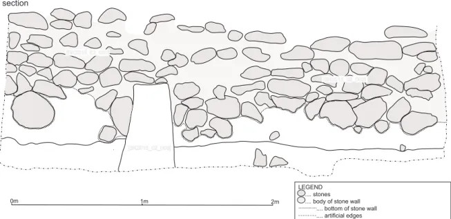
Fig. 3: Section A of the BK01 showing inner face of the rampart (by J. Kysela, J. Souček and J. Havlík).
In the eastern part of the trench the wall continues in the same direction but with a completely different construction: this wall portion (BK2015_01_003) is wider (ca. 150 cm) made out of two stone faces the space between them being filled in with very fine and hard beaten clay and only a relatively few stones. The faces of the wall are built of stones ca. 20–30 cm long (slightly flatter and wider than in BK2015_01_005) laid perpendicularly to the wall axis. Only the foundations of the wall are made out of big boulders ca. 30×50×? cm.
The two portions meet in a place where the wall is damaged by a cut BK2015_01_009 inter-secting the wall and the layers immediately behind it in the entire eastern part of the trench, damaging thus all information concerning the stratigraphic relations between the wall and
[BK2015_01_005] [BK2015_01_008] [BK2015_01_005] [BK2015_01_005] [BK2015_01_009] [BK2015_01_035] Burgut Kurgan Season 2015
Trench 01 - final phase of excavations section
LEGEND .... stones .... body of stone wall .... bottom of stone wall .... artificial edges 0m 1m 2 m
Burgut Kurgan Season 2015
Trench 01 – final phase of excavations section [BK2015_01_005] [BK2015_01_008] [BK2015_01_005] [BK2015_01_005] [BK2015_01_009] [BK2015_01_035] Burgut Kurgan Season 2015
Trench 01 - final phase of excavations section
LEGEND .... stones
.... body of stone wall .... bottom of stone wall .... artificial edges 0m 1m 2 m
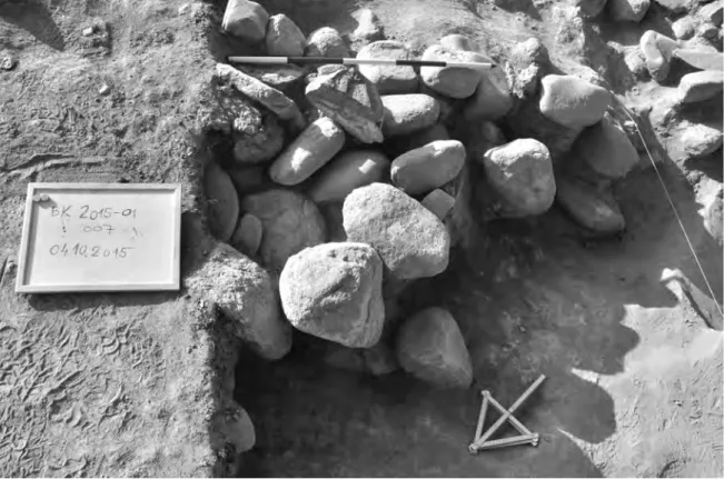
the settlement horizons. In the easternmost part of the pit, an accumulation of thickly packed stones (BK2015_01_007) is best interpreted as a buttress meant to reinforce the inner face of the wall. The stones are not regularly structured, sometimes with substantial gaps between them, giving the construction quite a makeshift impression (Fig. 4).
Fig. 4: The stone buttress BK2015_01_007 of the wall BK2015_01_003 (photo by J. Kysela).
No foundation trench was identified during the excavation. Nevertheless, when the inner faces of the wall became unearthed in the course of the following excavation, it became clear that: 1) there are no settlement horizons functioning with the wall at the level of its foundation (while there are some higher above) and 2) close to the foundations of BK2015_01_005 there are two stones set vertically and adhering to the wall face only because they are stuck to it by means of clay. These stones were very probably meant to bolster the wall’s foundation in the – no longer recognizable – trench. The wall was therefore very probably built into a foundation trench. Its depth varied according to the thickness, resistance and stability of the horizons encountered during its carving (Fig. 5).
The reasons for this particular construction sequence seem to be internal rather than ex-ternal: In the northern part of the trench, the layers of preceding horizons (including those on the top of which the walls were built) are consistently inclined towards the east. We may assume that they subside towards a spacious underground cavity. By the time the wall was being constructed, this subsidence process was still in progress and continued at least for some time afterwards. Either it damaged the wall BK2015_01_005 which was in consequence substituted by a lighter construction BK2015_01_003/004 or the constructors presumed this problem and tried to counteract it by the choice of this lighter construction. In any case, this precaution did not work and the ground movement literally tore the two portions of the wall
apart (i.e. the cut BK2015_01_009, was created by the effects of gravity, not by human action). The inhabitants obviously tried to remedy this problem by filling in the pit with boulders, thus also creating at the same time a buttress (BK2015_01_007) reinforcing the weakened wall. Their construction abilities or will at this point were, however, far removed from those with which the wall was constructed.
There are only a few settlement horizons associated with the wall in function. In the eastern part of the trench, they are disturbed by the soil subsidence (pit BK2015_01_009). In the west-ern part of the trench, only the thick hard trodden level (probably floor) immediately behind the rampart wall (BK2015_01_011) may be taken into account.
Horizon 3 – the mudbrick architecture and associated settlement horizons
The horizon preceding the construction of the rampart wall is characterised by lighter mudbrick constructions. These walls are parallel with or perpendicular to the rampart wall as is also the case elsewhere on the site. It is therefore obvious that these two phases reiter-ate the same architectural scheme at two different moments. From the evidence observed in trench BK01 it cannot be said if the architecture was entirely mudbrick or if there was a stone rampart wall also in this horizon, to be subsequently completely covered by its later reconstruction – the wall documented in the horizon 2.
The mudbrick architecture was detected both on the terrace behind the rampart wall and in the trench extension down the slope. In this latter part of the trench, the mudbrick walls (constructed in the direction of level curves at regular distances between each other)
ap-Fig. 5: Vertically set stones sticking to the inner face of the wall BK2015_01_005 – probably remains of the bolstering of the original foundation trench (photo by J. Kysela).
parently constituted a kind of terracing walls structuring the slope. The slope was, however, very strongly affected by erosion: it was entirely covered with the thick uniform deposits consisting of decomposed mudbrick, loess, occasional charcoal and considerable amounts of pottery (relatively low degree of fragmentation) with no signs of stratification and only the outlines of constructions. As a result, the definition of the exact nature and stratification of the terraced northern slope remains one of the tasks for the excavation seasons to come.
On the flat terrace behind the rampart, the mudbrick walls feature all the same orientation (NE -SW/NW -SE) and construction details (a single course of mudbricks 33×22 and 33×15 cm). The wall BK2015_01_016 runs parallel to the rampart with a partition wall BK2015_01_027 perpendicular to it, while the wall BK2015_01_029 making up a right angle follows the same orientation. Though following the same scheme, the two walls are slightly offset and touch only narrowly with their corners. There is no obvious point of contact between these walls and the rampart since they were damaged by the foundation trench of the rampart wall and the cut BK2015_01_008. An outline of a mudbrick in the southern profile beneath the rampart wall, nevertheless, hints that the wall originally continued in this direction. The mudbrick walls were only poorly discernible in plan and practically invisible from the side view. For this reason, it is very difficult to estimate their preserved height and the foundation level. The preserved height does not seem, however, to be more than one or two courses of mudbrick. The standing parts of the walls might well have been pulled down and removed during the construction of the stone rampart.
South of the wall BK2015_01_027 runs a course of pebbles BK2015_01_024 parallel with it. The hard trodden level into which it seems to be set can be reasonably interpreted as a floor.
No obvious floors have been identified in the rest of the trench. Although the deposits associated with the mudbrick walls featured quite frequent horizons of accumulations of big pottery fragments lying flat, which may have been on the surface at one point, there is no stratigraphic confirmation of this hypothesis (Fig. 6).
Fig. 6: The earthen wall BK2015_01_027, course of pebbles (foundation?) BK2015_01_024 and a pre-served portion of floor BK2015_01_025 (photo by J. Kysela).
In the eastern part of the trench (within the angle of BK2015_01_029) the lowest attained levels are pronouncedly sloping towards the centre of the terrace. A similar centripetal ten-dency of layers was also observed in the eastern profile of the northern extension and – as mentioned above – in the rampart wall (BK2015_01_005).
On the inner edge of the terrace where the northern extension begins, in a roughly square area delimited by the mudbrick walls BK2015_01_016 and BK2015_01_023 was encountered a de-posit constituted mainly of disordered mudbrick fragments (BK2015_01_021). This layer does not seem to have constituted a floor (the surface was extremely irregular) but rather a levelling deposit. The interface between this layer and BK2015_01_028 below it followed, indeed, the above described centripetal direction, characteristic of the other layers of this stratigraphic horizon. The scope of the mudbrick accumulation BK2015_01_021 was therefore probably to fill in the depression and to level the ground for the construction of the mudbrick walls. Horizon 4 – an earthen mound?
The layer BK2015_01_028 was excavated in the constricted area of 2×2 m. The deposit con-tinued in the depth of ca 80 cm where it sat directly on the virgin soil. The layer was extremely poor in finds. Occasional sherds, animal bones, charcoal and fragments of mudbricks prove, nevertheless, that the layer is at least anthropised (i.e. naturally deposited while different hu-man activities were taking place in the vicinity) if not directly anthropogenic e.g. a backfill of a building, an earthen rampart or another kind of earthwork. If the latter suggestion was true we might hypothesize a proto -rampart (an earthen one or stone wall back with earthwork) since the very foundation of the settlement.
CONCLUSIONS
The excavations in the trench BK01 enabled us to distinguish preliminarily four stratigraphic horizons of the terrace in the south -eastern margin of Burgut Kurgan.
The earliest of these horizons consisted of a man -made accumulation of earth, possibly a rampart mound or a backfill of an empty space. Roughly in the centre of the south -eastern terrace we may hypothesise a spacious cavity (an underground space or a collapsed building), whose (insufficient) backfill kept subsiding during the lifetime of the following horizons, causing serious stability issues to the later constructions. A pack of clayish loess, interlaid with horizons of flat lying sherds testifies to continuous human activities in the site between the levelling of the cavity and the construction of the mudbrick walls of the following horizon. The following horizon is characterised by light mudbrick walls. Very probably, only their foundations are preserved while the rest was pulled down during the construction of the following horizon. For this reason, a single floor portion is preserved.
The latest settlement horizon is marked with the stone rampart wall (Fig. 3). Only a few settlement horizons are associated with it. An interesting point to note is the contrast between the workmanship and effort invested into the construction (and/or the first reconstruction) of the wall and the sloppiness of the buttress intended to stop its decay.
Sometime after the eventual abandonment of the settlement and the collapse of the wall, the canal was cut through the rampart. The basin created inside the Iron Age settlement by its circumvallation might have been used as a water reservoir in this period.
TRENCH BK02
LOCATION
Trench BK02 is located in the northern part of the site (Fig. 1 and 7), in a place where both the rampart and the archaeological levels were apparently well -preserved according to the topography.
Fig. 7: Ground plan of the Trench BK02, final phase of the excavations (by J. Kysela, J. Souček and J. Havlík).
THE TRENCH AND THE METHODS
The trench covers an area of 6×4 m, with an orientation north -north -west/south -south -east, conditioned by the location of the rampart: it encloses both sides of the presumed wall and part of the internal settlement.
The uppermost levels were excavated by successive artificial layers, in order to reach the archaeological levels. The first archaeological layers were reached at 15–20 cm under the mod-ern surface. Altogether, the preserved archaeological levels were ca. 1.3–1.6 m thick.
THE RESULTS AND THEIR INTERPRETATION
As a result, four stratigraphic horizons were discovered, here presented from the latest to the oldest, corresponding to two occupation horizons interrupted by two short abandonment horizons. [BK02-002] [BK02-024] [BK02-021] [BK02-011] [BK02-006] [BK02-018] [BK02-019] LEGEND .... stones .... mudbrick wall .... body of stone wall
.... potential edges of mudbrick wall .... artificial edges
N
Burgut Kurgan Season 2015
Trench 02 - final phase of excavations groundplan
0m 1m 2m
Burgut Kurgan Season 2015
Trench 02 – final phase of excavations groundplan
Horizon 1 (abandonment horizon 2)
Immediately under the surface layer BK2015_02_001, a line of boulders appeared, corre-sponding to the inner face of the rampart, with a NNE -SSW orientation (BK2015_02_002). While the inner face was well -preserved (Fig. 8), the outer face of the wall was extremely damaged. Collapsed stones were numerous at the surface and at more than 1 m depth, and, once the face could be identified, it appeared that it was not continuous anymore, with many stones lacking. Considering the position of this part of the wall on the northern border of the site at a place facing the wind, this is not surprising.
Underneath, the first layers we identified correspond to wind -driven deposits (BK2015_02_003), a ca. 30 cm thick grey -brown, pulverulent layer, with some potsherds lying without any order. These deposits are thinner in the south -eastern part of the trench. They covered some abandonment layers subsequent to the last occupation of the area.
First, BK2015_02_004 is very similar in its texture but contains more potsherds – usually lying with a slight dip –, one quern, and some fragments of mudbricks.
Below it, BK2015_02_005 contains numerous potsherds and some stones 10–15 cm in diam-eter, corresponding to small stones from the collapsed rampart wall BK2015_02_002.
A layer 1–2 cm thick with numerous inclusions of insects’ nests and some places of hard clay corresponds to the first exposure of the area after its abandonment at the end of horizon 2.
Fig. 8: Section A of the BK02 showing inner face of the rampart (BK2015_02_002; by J. Kysela, J. Souček and J. Havlík).
Horizon 2 (occupation horizon 2)
We identified the earliest evidence of occupation of the area beneath this thin layer. It is obviously linked to the use of the stone rampart BK2015_02_002. While its five uppermost rows of stones can be attributed to the later stage, the lowest rows on the other hand belong to the earliest occupation (see below), and the wall shows clear evidence of repair. In particular, some potsherds belonging to the earliest occupation (BK2015_02_008, see below) were cov-ered by stones used to repair the wall (Fig. 9). The wall is built with medium -sized boulders
[BK2015_02_006] [BK2015_02_002] [BK2015_02_002] 0m 1m 2m Burgut Kurgan Season 2015
Trench 02 - final phase of excavations section
LEGEND .... stones .... body of stone wall .... bottom of stone wall .... artificial edges
Burgut Kurgan Season 2015
Trench 02 – final phase of excavations section
ca. 30–40 cm long, closely packed in their longer axis. Spaces between the stones, as well as both faces of the wall, were probably coated with clay.
We were able to identify some constructions inside the enclosure of the wall. The ar-chitecture consists of a mudbrick wall (BK2015_02_006), perpendicular to the stone wall BK_2015_02_002, to which it is linked by a clay coating, evidencing their contemporary use (Fig. 10). Wall BK2015_02_006 is made of one single row of mudbricks, which are 36–38×22– 25×9–10 cm. It is preserved on two courses only and ca. 2 m length, going further under the south -south -eastern limit of the trench.
This wall delimits two different areas (Fig. 9) that can be interpreted as rooms, which were probably covered since no water infiltrations were evidenced, and whose limits could not be determined due to the small extent of the trench.
Fig. 9: Inner face of the stone rampart BK2015_02_002 and the mud -brick wall BK2015_02_006 sepa-rating the two rooms. In the southern one, part of a floor BK2015_02_007 was uncovered (photo by J. Kysela).
South of the wall BK2015_02_006, a contemporary floor was identified. This floor BK2015_02_007 consisted of a grey -brown, 2 cm thick clay coating mixed with vegetal temper. It was covered with a brown, thin layer containing numerous potsherds, lying flat and belonging mainly to large storage jars and to wheel -fashioned bowls, some of them archaeologically complete after restoration. Below this level, numerous potsherds sometimes belonging to the same vessels were found in BK2015_02_008, a dark brown layer ca. 15 cm thick with a very dense accumulation of ceramics.
North of the wall BK2015_02_006, the floor BK2015_02_009 was covered with much fewer potsherds, suggesting a different use for this room.
Fig. 10: Collapsed stones (BK2015_02_010) inside the room formed by rampart and the two mudbrick walls (BK2015_02_006 and BK2015_02_011) (photo by J. Kysela).
Horizon 3 (abandonment horizon 1)
A dense concentration, ca. 35–40 cm high, of medium -sized stones lying without any order was identified on both sides of the wall BK2015_02_006, and below the levels BK2015_02_008 and BK2015_02_009 (Fig. 10). BK2015_02_010 corresponds to the cleaning of these stones in a vain attempt to find a pattern of organisation. Only a few potsherds are associated with the stones. This stone heap probably results from the collapse of stone wall BK2015_02_002 after a previous occupation horizon. Some of these stones are overlaid by the wall BK2015_02_006, clearly confirm that the collapse happened between the two main occupations of the area. Horizon 4 (occupation horizon 1)
The collapsed stones covered the remains of the first occupation of the area. It corresponds to the construction and first use of the stone wall BK2015_02_002. At this level, it is clear that the wall was not straight, but curved in order to follow the natural topography of the hill. It is 1.50–1.67 m wide, preserved at a total height of 1.1–1.3 m, corresponding to six courses of stones (Fig. 11). The three lowest courses are of one stone (ca. 20–25 cm) larger than the upper ones, a technique used to stabilize the wall. It likely corresponds to the filling of a foundation trench that could not be identified due to the later rebuilding of the wall.
Fig. 11: Stone rampart in BK02 (BK2015_02_002; photo by J. Kysela).
Some internal mudbrick architecture was identified. It consists of a mudbrick wall BK2015_02_011, which is built in the same way as the later wall BK2015_02_006. It is one row of mudbrick wide only, using mudbricks 34–35×19–20×9–10 cm. It is preserved on two courses only and its top level is lower than the base of wall BK2015_02_006, maybe indicating a vol-untary levelling of the area prior to the second occupation. This wall is roughly parallel to the rampart wall BK2015_02_002, which indicates a total shift of the internal planning of the settlement between the two settlement horizons, though both are connected to the rampart wall and separated by a short hiatus only.
The area located between the walls BK2015_02_011, BK2015_02_002, and BK2015_02_006 (though this wall is later), east of the collapsed stones, was filled with layer BK2015_02_012 (Fig. 10). The stones were lying on a level of floor BK2015_02_015, covered with numerous potsherds. In the area located north of wall BK2015_02_006, BK2015_02_014 was found un-der the collapsed stones. It corresponds to a floor, hardened by circulation but not built on, like BK2015_02_015. The area located west of the wall BK2015_02_011 was filled with layer BK2015_02_013 and below it by BK2015_02_016 (Fig. 10). There too, numerous large potsherds belonged to vessels crushed when the area was abandoned. BK2015_02_016 contains one quern and one pestle. The layer below, BK2015_02_019, also contains one quern and sherds from cooking pots. These discoveries evidence a domestic purpose of this room.
Evidence of the earliest occupation stage – though without any hiatus in the meanwhile – were found under these circulation/occupation floors BK2015_02_014 and BK2015_02_015, indicating a long occupation of the area. BK2015_02_017 is thus located beneath BK2015_02_014,
and BK2015_02_018 under BK2015_02_015. Both layers, and mainly BK2015_02_018, contained numerous potsherds.
Some pits, two of which were identified, were dug at these levels. Pit BK2015_02_021 is oval -shaped (50×80 cm, ca. 65 cm deep). It was filled (BK2015_02_020) with a soft, dark brown soil, with some potsherds fitting with potsherds from BK2015_02_013. Pit BK2015_02_0243 is also oval -shaped (58×45 cm, 28 cm deep), with a very similar filling (BK2015_02_023). Im-mediately beneath the remains of this first settlement, virgin soil was reached at 1.45–1.8 m from the surface level.
CONCLUSION
The excavation of Trench BK02 enabled us to highlight a long occupation of the settlement, characterized in that area by two main occupation horizons. The rampart wall is present from the very beginning of the occupation of the area, immediately on the top of the virgin soil. Af-ter its partial collapse at the end of this first settlement, the wall is rebuilt and the area roughly levelled off in order to be reoccupied. The nature of the settlement did not strongly evolve until its final abandonment, despite some changes in the architectural internal planning. No evidence of occupation has been identified outside the perimeter enclosed by the stone wall. The small extent of the trench did not allow the solving of the question of the nature of the settlement, though the plentiful evidence of a domestic occupation of the area enable one to reject the hypothesis of a corral. The function of the stone wall also remains subject to questions, since its use as a rampart is far from being certain, especially since no evidence of a military function of the settlement were found. However, it definitely played a protective role by enclosing the settlement. Based on what can be observed in present -day neighbour-ing villages, the upper part of this rampart wall was likely built with pakhsa3 or mudbricks. A similar technique was used during the Late Bronze Age and Early Iron Age settlements of the Vakhsh Valley in south -western Tajikistan (P’yankova 2001; Vinogradova 1996, Fig. 2), though these stone foundations are usually smaller in size than in the case of Burgut Kurgan.
TRENCH BK03
THE TRENCH AND WORK PROGRESS
Trench BK03 is oriented roughly ENE -WSW (Fig. 1 and 12). It was originally opened as a 2×1 m test pit. The first archaeological structures soon appeared therein. The trench was therefore extended northwards (reaching 2×6 m), and another 1×7 m trench was added to connect this extended trench with the rampart visible in the topography. This trench was then enlarged by 2 m southwards. Finally, the space between its border and the first sounding was also opened to form a large rectangular area, the surface of the excavation reaching 54 square meters (6×9 m) by the end of the work. The strategy chosen in Trench BK03 therefore differs strongly from the method adopted in trenches 1 and 2, excavation on a large area prevailing over a deep excavation.
Fig. 12: Ground plan of the Trench BK03, final phase of the excavations (by J. Kysela, J. Souček and J. Havlík).
THE RESULTS AND THEIR INTERPRETATION
Most of the remains discovered are related to one single occupation horizon, although some elements suggest an earlier occupation. Since the virgin soil has been reached only close to the centre of the settlement, in places where archaeological deposits were very thin, we cannot exclude the hypothesis of another, ancient occupation horizon in the areas closer to the rampart wall.
The archaeological levels we excavated are 0.75 m thick only at their highest point. Indeed, the upper part of the corresponding levels are highly eroded in this part of the site.
[BK03-006] [BK03-011] [BK03-017] [BK03-016] [BK03-004] [BK03-006]� [BK03-015] [BK03-012] [BK03-022] [BK03-009] Burgut Kurgan Season 2015
Trench 03 - final phase of excavations groundplan
LEGEND .... stones .... pottery .... mudbrick wall .... body of stone wall
.... potential edges of mudbrick wall .... artificial edges N 1m 0m 2m Burgut Kurgan Season 2015
Trench 03 – final phase of excavations groundplan
Horizon 1
Surface layer BK2015_03_001, which already contained some potsherds, covered in some places a pulverulent, whitish layer BK2015_03_003, on average ca. 15–20 cm thick but getting thinner, or even absent closer to the site centre. This layer corresponds to wind -driven deposits subsequent to the abandonment of the site.
Underneath we found either directly the first built structures, or layers corresponding to the filling of the area after its abandonment. This is the case of the brown layer BK2015_03_010, which is found only in places close to the rampart wall, where the stratigraphy is thicker.
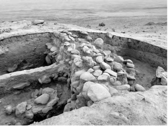
The highest and best -preserved structure is the surrounding stone wall BK2015_03_004 (Figs. 12 and 13). It was better preserved than we expected. It is ca. 1.30 m wide, made of five parallel rows of boulders. We cleaned four courses of stones and reached the footing bottom of the wall just beneath. In the northern part of the trench, the wall seems to be higher; but in the southern one, the three uppermost courses are erected on layers related to a previous occupa-tion, though we cannot exclude the hypothesis that a first rampart wall was already present in this earliest settlement, since we reached only the top of these layers. This discrepancy in the conservation of the wall provide another argument suggesting the collapse of some parts of the wall and its rebuilding later on. Furthermore, a layer made of hard clay, very similar in its nature to bricks, was found between a mudbrick wall (BK2015_03_011) and this rampart wall, maybe in order to support it. This point has to be investigated further by the future excavations.
Inside the rampart, the first structures and architectural remains were found immediately beneath BK2015_03_001 or BK2015_03_003, depending on the slope inclination, at only 25 to 70 cm from the modern surface. We identified remains of mudbrick architecture, stone structures, domestic facilities, and related occupation layers.
Fig. 13: Trench BK03, general view from the north with rampart (BK2015_03_004) on the right (photo by J. Kysela).
Fig. 14: Trench BK03, general view from the north -west with rampart (BK2015_03_004) on the right and pottery -plastered room (a kata?) in the centre (photo by J. Kysela).
Four mudbrick walls have been identified (Figs. 12–14). The first wall BK2015_03_006 is ori-ented roughly east -west. It is made of one row of bricks and it is visible in the trench at a ca. 5 m length, but continues further westwards. The second wall BK2015_03_011 is parallel to BK2015_03_006 at 2.58 m to the south -east. It is also made of one row of mudbricks. Further south -east, the third wall BK2015_03_017 is parallel to walls BK2015_03_006 and BK2015_03_011. The fourth wall BK2015_03_016 is perpendicular to the walls BK2015_03_006, BK2015_03_011 and BK2015_03_017. It was well preserved at a ca. 3.5 m length but we may not exclude the possibility that it joined the wall BK2015_03_006. The mudbricks used in these walls are of two different sizes, some 23–25×18×10 cm, and the others 41×24×10 cm, separated by a ca. 4 cm thick jointing. The described mudbrick walls delimited rooms which were probably roofed since no traces of an exposure to water or wind have been identified.
Three stone structures are closely linked to this mudbrick architecture, all of them with an east -west orientation similar to the orientation of the walls, and all made of one course of stones only. The first stone structure BK2015_03_002 is located in the eastern corner of the trench. It is made of two rows of large boulders (60×30 cm) on the southern side, and two rows of medium--sized boulders, of 1.4 m width and 2 m length. The second stone structure BK2015_03_007 is located in the south -western corner of the trench, not far from the rampart wall BK2015_03_004. It is flanking the mudbrick wall BK2015_03_006 at a ca. 1 m length. It is made of some medium--sized boulders in one row. The third stone structure BK2015_03_015 (Figs. 12–14) is located east of the mudbrick wall BK2015_03_016, perpendicular to it, and parallel to stone structures BK2015_03_002 and BK2015_03_007. It is made of one row of four large boulders, of 90 cm length and 30 cm width. The function of these structures is not clear, but their tight link with the mud-brick architecture enable us to suggest a domestic use, maybe as benches located inside the rooms.
On both sides of the wall BK2015_03_006, the layers BK2015_03_008 include a succession of a soft brown, 15 cm thick layer, and an ashy, dark brown -black layer that contains some medium -sized stones. They correspond to occupation layers. They are visible under the ram-part BK2015_02_004, and some of the stones clearly go under it.
These occupation layers are linked to a floor BK2015_03_013 made of a 2 cm thick, yellow/ light brown layer, covered by a clay coating with inclusions of a vegetal temper. A small sound-ing east of the wall BK2015_03_006 showed that it covers another level of a pulverulent, brown layer with inclusions of small pieces of charcoal, indicating a previous occupation. It is located at the base of the uppermost course of the mudbrick walls. Three hypotheses may explain it: either these walls have been eroded, or they have been levelled off before a new occupation of the area, the traces of which have disappeared, or they are linked to an earlier occupation. The only domestic structures that could be identified on this floor are two small fireplaces. The first fireplace BK2015_03_009 was found in the western corner of the trench, east of the wall BK2015_03_006, at about 10 cm from it. It is oval -shaped, ca. 45×33 cm and 4–5 cm deep, and it was simply dug in the soil. It was partly reddened by fire and was filled with an ashy layer and small to medium -sized pieces of charcoal. The second fireplace BK2015_03_012 is located at the same level, against the wall BK2015_03_006 further east (Figs. 12 and 13). It is built using a different technique: a round clay wall, 8 cm thick, borders it, and two large stones are also put in the wall to reinforce it. With the dimensions of 60×70 cm, and 12 cm deep, it is thus very similar to the modern tandyrs.
South -westwards, the space between the mudbrick wall BK2015_03_006, the stone struc-ture BK2015_03_015, and partly the mudbrick wall SU03_016 is filled with layer BK2015_03_020, which contained potsherds, a clay whetstone, and some fragments of mudbricks. Beneath it, the level BK2015_03_021 is an ashy layer with patches of reddened clay, containing numerous blackened sherds from cooking pots, and some fragments of stones heated until they broke. This layer may be related to the two fireplaces described above, suggesting a domestic function for this part of the settlement. This space was probably bordered on the north -east by a wall parallel to the wall BK2015_03_016, but this part of the site was strongly eroded.
Further south -west, the space delimited by the wall BK2015_03_016, the stone structure BK2015_03_015, and the border of the trench was filled with BK2015_03_019.
Finally, the room delimited by the three walls BK2015_03_011, BK2015_03_017, BK2015_03_016, and by the rampart wall was filled with BK2015_03_018. Underneath, we found the layer BK2015_03_022 at the base of which we discovered a floor level covered with a very dense accumulation of potsherds, lying flat and tightly put one against the other in order to pave the entire surface of the room, covering also the base of the walls (Figs. 12–14; Pl. 3/3). These sherds were representative of all the usual pottery production of the Early Iron Age.
Horizon 2
In the south -western part of the trench, the stone wall lies on top of the remains of an earlier occupation, characterized by soft, dark layers typical of a settled area. However, these levels were not excavated during this season.
We made a small sounding in the north -eastern corner of the trench to evaluate the thickness of the occupation levels in that area. We identified under the stone structure BK2015_02_002 a level of water -driven deposits ca. 10–15 cm thick (BK2015_03_005). Beneath it, a soft dark brown layer may be related to an occupation, but it was very thin and we were not able to qualify the nature of this occupation given such a small extent.
Underneath, the virgin soil was very close, at 1.2 m only from the highest point of the trench surface.
CONCLUSION
Trench BK03 delivers a much -contrasted picture. It appears that the stratigraphy is well pre-served only close to the ramparts and that archaeological levels are very thin in the centre of the settlement. It seems that there are two successive occupation horizons like in trench BK02, but the remains of the first one are still to be excavated.
At the same time, the remains we were able to identify are very representative of the dif-ferent structures. Some of them are found for the first time at an Early Iron Age settlement, especially the small benches made of stones, while the stone walls are known only in some mountainous areas of south -western Tajikistan, in the Vakhsh Valley. The fireplace with a clay border is similar to some fireplaces discovered recently at Dzharkutan in the Early Iron Age settlement (Bendezu -Sarmiento – Mustafakullov 2013, Fig. 17A). Dzharkutan is only about 30 km from Burgut Kurgan, and this construction technique may be considered a local one. Pieces of charcoal from these fireplaces have been sampled for radiocarbon dating, and we may expect soon some specification regarding the chronology of the settlement. Similarly, the archaeological deposits from the ashy structures (layers or fireplaces) have been sieved in order to get samples for archaeobotanical studies, which will undoubtedly give precious information regarding the subsistence economy.
The most intriguing discovery is represented by the floor paved with potsherds. No similar discoveries have been made so far in an Early Iron Age settlement; however, some analogies may be found with structures from the Bronze Age settlement of Gonur -depe in Margiana (Turkmenistan). V. I. Sarianidi identified in Gonur South a group of three buildings he con-sidered as part of a water temple. There, in the hall occupying the central part of the eastern building, he excavated structures he interprets as double -hearths raised on low platforms; the burner’s floor of one such double -hearth is covered with fragments of pottery (Sarianidi 2006, 179, Fig. 49). According to Sarianidi, this complex was used to prepare food sacrifices. Although we may consider this interpretation with caution, it raises the hypothesis of a religious or cultic function of this structure. According to Sh. Shaydullaev, another possible explanation is linked to the mortuary practices: the most common practice during the Early Iron Age was excarnation (Bendezu -Sarmiento – Lhuillier 2015), and this room may have been used as a kata, a tem-porary shelter for the corpse when it is impossible to move it to the dakhma (Vendidad VIII, 2). Indeed, a corpse may be left in a room before its transport to the dakhma, if it is in a place larger than the body with the arms and the legs stretched. The text from the Vendidad refers to a place located in private houses (Cantera 2002), where the floor “is the cleanest and the driest, and the
least passed through by flocks and herds, by the fire of Ahura Mazda, by the consecrated bundles of Baresma, and by the faithful” and is covered “with dust of bricks, of stones, or of dry earth”. Although
we may notice some differences with the text – and especially the location of this room near a living space with a domestic use – we observe at Burgut Kurgan the same will to protect the floor. This important point has to be investigated by further excavation in the area.
MINOR TRENCHES
TRENCH BK04
In the central part of the site (Fig. 1), a small Trench BK04 was opened in order to clarify the function of a pile of stones placed in this place and its relation to the settlement. Hypotheti-cally it could be the remains of a small kurgan built after the abandonment of the site.
Addi-tionally, we aimed to find out, whether there are any architectural remains or archaeological deposits in this central depression or not. Two halves of the square trench measuring 3×3 m were gradually opened and excavated as a section of the stone feature down to the subsoil (ca. 40 cm under the present day surface). As a result, we were able to prove that the stones did not cover any pit and their original function remains unclear. Besides we did not find either stone or mudbrick structures, nor obvious cultural layers here. This fact seems to attest our assumption that the central part of the site was either not built on during the existence of the Yaz I settlement, or the hypothetical deposits were eroded by water brought by a secondarily built canal that was excavated in BK01 and described above.
TRENCH BK05
The second minor trench was placed outside the ramparts to the south -west of the micro--citadel across the shallow ditch visible in the field only during the dusk or dawn thanks to the
oblique light. The dimensions of this section were 1×4 m. Our aim here was to investigate the ditch itself and to try to confirm or disprove the hypothesis that the linear feature once served as a water -bringing canal. The excavations here, however, did not bring a definite answer to this question, since the traces of the ditch were too indistinct. As proven by the stratigraphy of the Trench BK01 (see sub -head Horizon 1 – post -Burgut Kurgan above), the canal – whatever its function was – was definitely later than the rampart and even than its collapse.
FINDS
The small finds from Burgut Kurgan basically consist of two categories regarding their mate-rial: pottery and stone tools. While the important pottery assemblage is discussed elsewhere in this volume in detail (Lhuillier 2016), the numerous stone objects – saddle querns, pestles, mortar, blades – are listed with basic characteristics in the table below.
The finds in the following table come mainly from the excavated contexts of Burgut Kurgan itself. A few of them, however, are from some of the newly detected settlements in the neigh-bourhood. BK in the table stands for Burgut Kurgan and KY for Kayrit (area) with a number indicating a specific site as described in the report by Stančo (see in this volume). Zero stands for finds from the surface in the TRENCH field indicating an absence of excavation context.
The table illustrates clearly that the inhabitants of Burgut Kurgan used stone tools exten-sively unlike metal ones that were – according to our current data – virtually unknown to them. Numerous saddle querns point to a prevailing subsistence strategy of the local population – agriculture. Among other finds we may notice a small number of animal bones. These are going to be analysed closely in the near future. The same goes for a small number of charcoal samples intended for radiocarbon dating.
METAL OBJECTS
One of the issues we had intended to solve during the project was the question of what metal prevailed in the contexts of the site, and eventually what type of metal objects were used by the presumably Early Iron Age people of the Yaz I culture. In order not to miss a single metal object in the excavations at Burgut Kurgan, metal detectors were employed to survey the site. Surprisingly, no metal that could be connected with the original occupation of the site was detected during the detailed metal -detector survey of the digs. All other metal objects, which
were detected in the surface layer at and around the site, belong to the Post -Mongol period or even to recent material. The most interesting items are represented by two well -preserved Medieval iron arrow heads that illustrates well the exploitation of the broader area of Burgut Kurgan in the second important period after the Early Iron Age: the High Middle Ages (see also Augustinová et al. 2015; Stančo 2016).
Tab. 1: Small finds from Burgut Kurgan.
Site Trench Excav. unit No. Type of object Material Dimensions (mm)
BK 00 000 1 Saddle quern Stone ca. 220×70×140
BK 00 000 2 Saddle quern Stone 110×65×70
BK 00 000 3 Saddle quern Stone 165×60×70
BK 00 000 4 Stone blade? Stone 96×56×12
BK 00 000 5 Saddle quern Stone 225×130×55
BK 00 000 6 Saddle quern Stone 235×120×55
BK 00 000 7 Saddle quern Stone 190×180×40
BK 00 000 8 Arrow-head Iron 67×28×2; Tang: 61, r=4Overall 128; Blade:
BK 00 000 9 Arrow-head Iron Overall 74; Head+Neck 34; Head 28, r=9; Neck r=6–7;
Tang r=2–5
BK 00 000 10 Saddle quern Stone 200×135×75
BK 00 000 11 Pestle Stone 121×66×34
BK 01 006 1 Saddle quern, half Stone ca. 200×200×60
BK 01 006 2 Saddle quern Stone ca. 230×150/160×50
BK 01 017 1 Pestle, flat Stone 99×68×34
BK 02 004 1 Saddle quern Stone 200×155×45
BK 02 015 1 Pestle Stone 128×77×65 BK 02 015 2 Pestle Stone 111×97×31 BK 02 016 1 Pestle Stone 86×56×26 BK 02 016 2 Pestle Stone 92×71×70 BK 02 019 1 Pestle Stone 105×35×28 BK 02 019 2 Pestle Stone 77×76×52 BK 03 003 1 Pestle Stone 100×60×45
BK 03 008 1 Chipped blade Stone 34×18×4
BK 03 008 2 Nut shell
BK 03 010 1 Pestle Stone 138×50×44
BK 03 010 2 Pestle Stone 77×49×49
BK 03 014 1 Mortar Stone 104×54×25
BK 03 020 1 “Whet stone”/ “Touch stone” Pottery 36×16×8
KY-V 00 000 1 Polishing tool (?)Pestle/ Stone 80×45×40
KY-V 00 000 2 Polishing tool Stone 145×50×65
CONCLUDING REMARKS
The works and results of the first season of the archaeological excavations at Burgut Kurgan attested clearly to the expected potential of the site and its ability to answer fundamental questions concerning the transitional period between the Late Bronze and Early Iron Ages in southern Central Asia. In the field season 2015 we succeeded in fulfilling several important goals of our project in the Pashkhurt Valley. Among the results we would like to highlight the following points:
1. It has been attested that Burgut Kurgan was a walled settlement of the Yaz I period, as assumed in 2014 already. The thickness of the stone ramparts reaches 1.2–1.6 m. The height in the best preserved portion (BK02) is 1.6 m. The rampart was repaired or rebuilt at least once and may even have a mud (pakhsa) predecessor.
2. Its inner ground -plan shows simple mudbrick architecture with two substantial building phases at least. The mudbricks used in the structures measure 33×22 and 33×15 cm.
3. No evidence of occupation has been detected outside the perimeter enclosed by the ramparts, neither by trenches that make sections of the rampart (BK01, BK02 and BK03), nor by the Trench BK05 placed further in the forefield.
4. The pottery of Burgut Kurgan is much more complex than we thought at first; we observed several phenomena that deserve our attention and further research in the future (see in this volume: Lhuillier 2016, 112–119), including the presence of wheel -made pottery related to the Late Bronze Age (Sapalli culture), and incised decorations having parallels in steppe cultures. A number of saddle querns (ten of them have been found at Burgut Kurgan so far) attests the importance of agriculture for the subsistence of Burgut’s Early Iron Age inhabitants. The scar-city of metal tools on the other hand raises further questions concerning the classification of the Yaz I culture (at least its local variant) to the Late Bronze or Early Iron Age – the majority of tools are made of stone (see Lhuillier 2013, 47 and 51–54).
5. One of the rooms unearthed in Trench BK03 may evoke the so -called kata described in Avesta (a place for the deposition of dead bodies in periods not favourable for their exposition in the most proper way in the Zoroastrian point of view – in dakhmas, i.e. especially in snowy or rainy season etc.). Such an interpretation demands further discussion particularly in the context of evidence brought recently by the late prof. Sarianidi (Sarianidi 2015).
6. A water canal connecting Burgut Kurgan with the Zarabag village seems to disturb the rampart encircling the site and thus is to be understood as a later construction or at least connected with the late (last?) phase of Burgut’s Early Iron Age functioning.
7. Burgut Kurgan does not represent an isolated settlement. It is rather just one (even if important) site belonging to a group or chain of both fortified and non -fortified settlements and religious structures and possibly also petroglyphs (cf. Augustinová – Stančo 2016) forming together a complex Yaz I oasis (Stančo 2016).
Although the trenches BK01, BK02 and BK03 met our expectations by the fact that the ar-chaeological situations were well preserved in sufficient extension and yielded substantial archaeological material, some key questions remain unresolved. As for the perspective of the future research at Burgut Kurgan, we shall focus on several issues. Since the excavation results obtained in the individual trenches slightly differ from each other, especially regarding the relation between the rampart and the inner mudbrick structures, we aim to prolong the ex-cavations of selected objects. Continuation of the work and broadening of the trenches (BK01 and BK02) could clarify these stratigraphic subtleties that are important for the early history of the site. This large scale focus on the earliest horizons should also include the removal of
a portion of the stone rampart and search for its eventual (stone- or mud- built) predecessor. Moreover, the situation to the west of BK01 and the connection between the terrace and the mound of the micro -citadel is a question of supreme interest, among other reasons because we expect better preservation of the inner mudbrick structures at this place, as well as longer use and complete stratigraphy of the site inhabitation there. Therefore, we aim to open a new large trench between the BK01 and BK03. This would also allow us to study structures related to the remarkable pottery -paved room in BK03 and hopefully confirm its funeral -related function. Further attention will be paid to the water canals and their dating.
ACKNOWLEDGMENTS
This report was prepared with the support of the Programme for the Development of Fields of Study at Charles University, No. P12 ‘History from the interdisciplinary perspective’, sub programme ‘Society, culture and communication in Czech history’.
BIBLIOGRAPHY
Vendidad = Vendidad (Vidēvdād) or Laws against the Demons. Avesta – The Sacred Books of Zoroastrianism, Book 3. Translated by James Darmesteter (From Sacred Books of the East, American Edition, 1898). Edited by Joseph H. Peterson.
Augustinová et al. 2015 = Augustinová, A. – Stančo, L. – Shaydullaev, Sh. – Mrva, M. 2015: Archaeological Survey in Micro -Oasis Zarabag (South Uzbekistan), Preliminary Report on the Season 2015. Studia Her‑
cynia XIX/1, 262–281.
Augustinová, A. – Stančo, L. 2016: The Petroglyphs of Pashkhurt Valley in the Surkhan Darya Province (South Uzbekistan) – Preliminary Report. Studia Hercynia XX/2, 112–137.
Bendezu -Sarmiento, J. – Lhuillier, J. 2015: Sine sepulchro Cultural Complex of Transoxiana (between 1500 and the Middle of the 1st Millennium BC). Funerary Practices of the Iron Age in Southern Central Asia:
Re-cent Work, Old Data, and New Hypotheses. Archäologische Mitteilungen aus Iran und Turan 45 (2013), 283–317. Bendezu -Sarmiento, J. – Mustafakullov, S. 2013: Le site proto -urbain de Dzharkutan durant les âges du bronze et du fer. Recherches de la Mission archéologique franco -ouzbèke – Protohistoire. In: J. Bendezu--Sarmiento (ed.): L’ archéologie française en Asie centrale. Nouvelles recherches et enjeux socioculturels. Cahiers
d’ Asie Centrale 21–22. Paris, 207–236.
Cantera, A. 2002: Über die Zwischenlagerung der Leichen im Zoroastrianismus. Archäologische Mitteilungen
aus Iran und Turan 34, 415–431.
Lhuillier, J. 2013: Les cultures à céramique modelée peinte en Asie centrale méridionale. Dynamiques socio‑
‑culturelles à l’ âge du Fer ancien (1500–1000 av. n.è.). Mémoires de la Mission Archéologique Française en
Asie Centrale XIII. Paris.
Lhuillier, J. 2016: Pottery from Burgut Kurgan and Kayrit Oasis, Preliminary Report for Season 2015. Studia
Hercynia XX/2, 112–121.
P’yankova, L.T. 2001: Poseleniya i zhilishcha predgornykh rayonov yugo -zapadnogo Tadzhikistana v epokhu Bronzy. In: A.V. Sedov (ed.): Drevnie tsivilizatsii Evrazii, Istoriya i kul’tura. Materialy mezhdunarodnoy nauchnoy konferencii posviyashchennoy 75-letiyu deystvitel’nogo chlena Akademii nauk Tadzhikistana, akademika RAEN, doktora istoricheskikh nauk, professora, B.A. Litvinskogo. Moskva, 14–16 okt’yabrya 1998 g. Moskva, 349–358.
Sarianidi, V.I. 2006: Gonurdepe, Turkmenistan. City of Kings and Gods. Askhabat.
Sarianidi, V.I. 2015: About Religious Concepts of the People of Ancient Margiana. Bulletin of Miho Museum 15, 46–62.
Stančo, L. 2016: Archaeological Survey in the Surroundings of Kayrit (South Uzbekistan), Preliminary Report for Season 2015. Studia Hercynia XX/2, 73–85.
Vinogradova, N.M. 1996: Kangurttut. The Ancient Agricultural Burial Ground in Southern Tadzhikistan.
IASCCA Information Bulletin 20, 171–194.
Ladislav Stančo Jan Kysela Jakub Havlík Johana Tlustá
Institute of Classical Archaeology
Faculty of Arts, Charles University in Prague Celetná 20, CZ-11000 Prague 1
ladislav.stanco@ff.cuni.cz; jan.kysela@ff.cuni.cz; havlikjak@seznam.cz; johana.tlusta@gmail.com
Julio Bendezu -Sarmiento
Délégation Archéologique Française en Afghanistan (DAFA)
Ambassade de France en Afghanistan, Kabul julio.bendezu@mae.cnrs.fr
Alisher Shaydullaev
National University of Uzbekistan
Faculty of History, Department of Archaeology Alabalar shaharchasi, Universitet-4
Tashkent, Uzbekistan alisher@myself.com
Shapulat Shaydullaev Odiljon Khamidov
Termez State University
Faculty of History, Department of History of Uzbekistan and Archaeology
190100, 42, Fayzulla Khojaev Termez, Uzbekistan
shapulat@mail.ru; odiljon-21@mail.ru
Johanna Lhuillier
CNRS UMR 5133 Laboratoire Archéorient MSH Maison de l‘Orient et de la Méditerranée 7 rue Raulin
F-69365 Lyon cedex 07 johanna.lhuillier@ens.fr
Pl. 2/1: Distribution of archaeological sites at Kayrit, eastern Pashkhurt Valley, Uzbekistan (map by author).
Pl. 3/1: Location of Burgut Kurgan in the eastern part of the Pashkhurt Valley, Sherabad District, south Uzbekistan (map by L. Stančo).
Pl. 3/2: Burgut Kurgan, general view from the SW (photo by J. Kysela).