Publisher’s version / Version de l'éditeur:
Engineering Journal, 43, 1, pp. 52-57, 1960-02-01
READ THESE TERMS AND CONDITIONS CAREFULLY BEFORE USING THIS WEBSITE. https://nrc-publications.canada.ca/eng/copyright
Vous avez des questions? Nous pouvons vous aider. Pour communiquer directement avec un auteur, consultez la première page de la revue dans laquelle son article a été publié afin de trouver ses coordonnées. Si vous n’arrivez pas à les repérer, communiquez avec nous à [email protected].
Questions? Contact the NRC Publications Archive team at
[email protected]. If you wish to email the authors directly, please see the first page of the publication for their contact information.
NRC Publications Archive
Archives des publications du CNRC
This publication could be one of several versions: author’s original, accepted manuscript or the publisher’s version. / La version de cette publication peut être l’une des suivantes : la version prépublication de l’auteur, la version acceptée du manuscrit ou la version de l’éditeur.
Access and use of this website and the material on it are subject to the Terms and Conditions set forth at
The new Aklavik: search for the site
Merrill, C. L.; Pihlainen, J. A.; Legget, R. F.
https://publications-cnrc.canada.ca/fra/droits
L’accès à ce site Web et l’utilisation de son contenu sont assujettis aux conditions présentées dans le site
LISEZ CES CONDITIONS ATTENTIVEMENT AVANT D’UTILISER CE SITE WEB.
NRC Publications Record / Notice d'Archives des publications de CNRC:
https://nrc-publications.canada.ca/eng/view/object/?id=4c857b6c-bbe3-42fa-ba2e-3ab4a87884f5
https://publications-cnrc.canada.ca/fra/voir/objet/?id=4c857b6c-bbe3-42fa-ba2e-3ab4a87884f5
Ser
:
THL
t
N2lt2
n o . 8 9
e . 2
B&DG
--,'
NATIONAL RESEARCH COUNCIL
CAI\ADA
DIVISION OF BUILDING RESEARCH
THE NEW AKLAVIK:
SEARCH FOR THE SITE
by
C. L. Merrill, J. A. Pihlainen and R. F. Legget
A i \ I A L Y i T D
REPRINTED FROM
ENGTNEERTNG IOURNAL, VOL. 43, NO. l, JANUARY 1960,
P. 52-57
TECHNICAL PAPER NO. 89
OF THE
DIVISION OF BUILDING RESEARCH
OTTAWA
FEBRUARY 1960
f
-uu'-tolf,5'^'t'-flncn
tdAR
22 1960
-lnltltrd. REsEARcH GouilcrENRC 5573
PRICE IO CENTS
-4' tL, Cz-5
(rtE
This publication is being distributed by the Division of Building Research of the National Research Council as a contribution towards bettor building in Canada. It should not be reproduced in whole or in part, without permisiion of the original publisher. The Division would be glad to be of assistance in obtaining such permission.
Publications of the Division of Building Research may be obtained by mailing the appropriate remittance, (a Bank, Express, or Post Office Money Order or a cheque made payable at par in Ottawa, to the Receiver General of Canada, credit National Research Council) to the National Research Coun-cil, Ottawa. Stamps are not acceptable.
A coupon system has been introduced to make payments for publications relatively simple. Coupons are available in denominations of 5, 25, and 50 cents, and may be obtained by making a remittance as indicated above. These coupons may be used for purchase of all National Research Council publica-tions including specificapublica-tions of the Canadian Government Specificapublica-tions Board.
THE NEW AKLAVIK
Search fo, the Site
C. L. Merrill,
Dtstrlct Administrator
Fort Smith. N.W.T.
I. A. Pihlainen, Jr.E.I.C., Northern BuildingSection
Dioi$on of Building Research,
National Research
Council.
R. F. Legget, M.E.I.C., Director,
Dir:,ision
of Building Research,
National Research Council, Ottaua, Ont.
rhis papet was pte*nted to the ottawa
::T;;,"1n#""jo"f::;:T"*I!;r';,I":T:;;i:;,"'rTf' tt' 1e56; to the Montreat Btanch on A KLAVIK, the main settlement of
-fl" Northwestern Canada. is located in the delta 'of the Mackenzie River about 68'N. (FiS. 1). This places it in approximately the same relation to the Arctic Circle as Fairbanks in Alaska (65'N), Reykjavik in Ioeland (64'N), Narvik in Norway (68'N) and Mur. mansk in the USSR (69'N). Compared to these other cities, Aklavik is a rela-tively small place with a permanent population of about 400, which in-creases to possibly 1500 during the short summer season when Indians and Eskimo come to visit the settlement. Despite this it is the most important Canadian outpost north of the Arctic Circle, and it will almost certainly steadily increase in importance with the development of the Canadian North.
The decision of the Government of Canada in 1953 to move the entire settlement to a new site is a matter of importance to all Canadians. This was the ffrst step in a development in connection with a town which is almost without precedent, apart from such special operations as the move of some mining communities (notably Sherridon to Lynn Lake) and the cur-rent work in relocating some of the municipalities on the Canadian side of the St. Lawrence River. The deci-sion to make the move was taken only after the most exhaustive studies, The selection of a new site was corre-spondingly made only after a most thorough investigation. It is the pur-pose of this paper to explain briefly the reasons for the move of Aklavik, the requirements for the new site, and the means employed, in carrying out the field survey work which event-ually resulted in the selection of a new loci'rtion for this northern out-post.
The start of Aklavik can be dated as recently as 1912 when a small fur trading post was established. In 1919 the famous Anglican Mission was started. The R.C.M.P. established a detachment at Aklavik in 1922 and the ffrst building of the signal station of the Royal Canadian Corps of Sig-nals was built in 1925. The Roman Catholic Mission was started in 1926 and in this same year the adjacent post of the Hudson's Bay Company (on the Pokiak Channel) was relocated. By 193I population of the settlement and the surrounding area had reached about 400. Today the population of the town and the surrounding delta country exceeds 2000, of whom about 307o arc white. 20% Indian and 50% Eskimo; many of the Indian and Es-kimo children live in the schools oper-ated by the two churches.
In addition to being the locatjon of the agencies already noted, the torvn is an important administrative centre for the Department of Northern Af-fairs and National Resources whieh is responsible for the administration of the Northwest Territories. More recent c:stablishments have included a Dc-partment of Transport racliosondo station and a naval siggral static'rr. The town is supplied with electric power by a local power company and is served by two river transportation companies. A scheduled mail and freight air service from F,'dmonton is operated by Pacific Western Airlines. The Mackenzie Delta
Aklavik owes its strategic location to the fact that it is on one of the main navigation channels in the delta of the Mackenzie River (Fig. 2). This is one of the greatest rivers of the world, eighth in order of magnitude based on discharge, eleventh in the
size of its drainage area and so about 50% larger than the St. Lawrence. The Mackenzie System is navigable by shallow draft boats for 1600 miles from rail head on the Clearwater River at Waterways, Alberta, to the Arctic Ocean, with only one break-the l2-mile stretch of rapids on break-the Slave River between Fort Fitzgerald and Fort Smith at the northern bound-ary of Atrberta. River transport is therefore operated in two stages on the upper and lower sections of the river system.
Because of the great load of sedi-ment which the river earries, its delta is spectacular (Fig. 3). It is one of the most remarkable physiographic features of Canada, but because of its location it is not as well known as some other major river deltas of the world, even though it is the twelfth largest. From Point Separation, where the delta properly starts, it is approxi-mately 150 miles to the Arctic Ocean. Unlike other deltas it is conffned-on the west by the Richardson Mountains and on the east by the Caribou Hills and other high land that is a result of slatcial action. Its maximum width is ibout 50 miles. Of this immense area about one half is rvater in the form of meandering channels and backwaters, small ponds, and many cut-off (oxbou) lakes.
The level area of the delta is no-where more than from 10 to 15 ft. above normal river level, and much of the area is flooded during high water in the spring. Such land as thele is appears generally to consist of silt covered by the inevitable mus-keg growth so typical of the North. This makes an ideal area for the breeding of muskrat and the delta is rve]l known as a muskrat hunting area. In ilte 5,275 square miles of the
delta rhere are over 900 people de-pendent on trapping. Income from muskrat furs has been declining dur-ing recent years and this is creatdur-ing a local problem. This is only one of the many problems regarding the future of Aklavik, however, which have had to be faced by those re-sponsible for its administration. Reasons for the Move of Aklavik
The entire delta area is perennially frozen so that the ground consists of material that can be described by the populal name permafrosf. This con-dition indicates that the temperature of the glound for an appreciable dis-tance beneath the surface (possibly 1000 ft.) is below freezing tempera-ture, apalt from the upper few inches which may tharv during the heat of summer'. The soil on r,vhich Aklavik rests is an organic silt with a very high natural moisture content. Subsurface investigations for the formation of a new school, which were carried out in 1953, showed that about 607" by volume of the frozen ffne-grained soil consisted of ice. If, therefore, the old town site were fulther developed with a further clearing of the muskeg cover and the installation of heated buildings, ground subsidence would occur with serious results.
The old town site is located on a bend in onc of the navigation chan-nels. The entire area adjacent to this site is flat and drainage has always been a particularly difficult problem. One feature of the area is stagnant pools of rvater formed by the melting of pelmafrost. Subsurface drainage is impossible and the ditches that are dug for surface drainage tend to com-plicate the dlainage problem by caus-ing still more thawcaus-ing of the perma-frost.
Because of the subsurface condi-tions, the laying of sewers or water-mains beneath the surface would similally create serious problems. To locate them above ground level and then to connect them to existing build-ings would be costly and unsatisfactory for the existing torvn conditions.
The area usecl for the torr,n is hemmed in bv the bend of the river and by swamps and ponds. There is, therefore, no practical r.vay for the torvn to expand, and expansion is vital if Aklavik is to fulfil its role as the centre of administration for north-west Canada. Not only is the present site restricted but it is even getting smaller because for some time the river bank has been eroding badly near the Roman Catholic Mission. Works to stop this natural action have
been estimated to cost several million dollars and their success wou]d be questionable.
Finally, if Aklavik is to serve prop-erly the expanding needs of the North, it is essential that it should have avail-able to it an airpolt that could be used throughout the year. Now each year', during the break-up period in the spring and the freezc-up peliod in the fall, the town is cut ofi from all flying services. Attempts have been made to construct an airstrip adjacent to the present torvn but the subsur-face conditions are sucl-r that this has proved impracticable. A small strip for very light planes does exist, but only rvith the expenditule of vast sums of money could a majol airstrip be developed.
These were the main factors that had to be considered with regard to the future of Aklavik as an expanding community of the Nolth. Confirmation by detailed soil testing of rvhat had boen suspected about subsulface soil conditions ffnally showed the need for over'-all consideration of the entire problem. It was this study that finally led to the decision that the only pos-sible solution was to ffnd a new site for the town.
Requirements for the New Site
Before any work could be done in attempting to locate a nerv site a clear pictule had to be developed of the requirements that any such site rvould have to meet. These could then pro-vide the guide posts for those who were to conduct the actual survey.
The essential factors for any new town site were determined as follows:
(a) the site must be suitable from economic and social points of view;
(b) the site should be suitable for the installation of permanent sewer and water systems, building founda-tions, and roads;
(c) the site should be on, or very close to, a good navigation channel within the delta;
(d) the site must have reasonably close to it a suitable area for the con-struction of a permanent first-class air field;
(e) there should be, within eco-nomical distance, a suitable public water supply.
The following were regarded as highly desirable features but were not quite so important as those al-ready listed:
(f) the site should provide for eco-nomical and convenient disposal of sewerage;
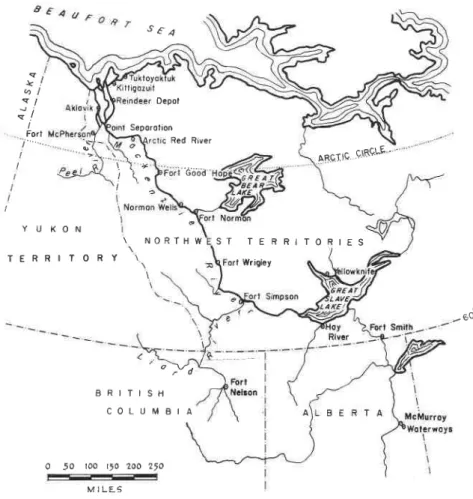
(g) it would be convenient if there were a good supply of gravel and sand t a l Fort i " S r ^ Depot SeDorolion Red River i - G o b ? I AB9T!A ciRqLF ' . S T T E R R I T O R I E S Y U K O N \ N O R T H W T E R R I T O R Y t Wrigley - E o
0 50 f00 t'o 2oo 25o M I L L 6
Fig. l. The Mackenzie Waterway.
\ i 7
I
B R I T I S H C O L U M B I A
learby for building purposes; (h) from the navigation point of view it would be desirable if the whalf facilities could be used as a trans-shipment point for freight from river vessels to sea-going vessels which could sail out into the Arctic Ocean.
Finally, the following three factors had to be kept in view as desirable but in no way essential:
(i) availability of a good wood supply;
(j) availability of coal for heating purposes, and
(k) if possible, availability of water power which could be used for the generation of power for public supply. Organization of the Survey Team
In January, 1954, when the re-quirements for the new site were speciffed, the agencies to be repre-sented on the survey team were selected. These agencies were the De-partment of National Health and Wel-fare, the National Research Council (Division of Building Research), the Department of Northern Affairs and National Resources, the Department of Mines and Technical Surveys, the Department of Public Works, and the Department of Transport. To the De-partment of Northern Affairs was as-signed the task of placing a team on the ground by March 15, 1954. The survey r,vas to extend through late win-ter, spring, and summer and the team was to report its findings by August
t , 1 9 5 4 .
The personnel included men trained in the social and physical aspects of the geographic, geologic, and engi-neering sciences. (See Appendix A for members of the team.) Each agency had responsibilities in the Ak-Iavik area. The Department of North-ern Affairs, with the primary adminis-trative responsibility, provided the project manager, C. L. Merrill.
In the few weeks during which the team was recruited, rvinter clothing, rations, camping and surveying equip-ment were obtained and, when neces-sary, shipped to Aklavik. During the winter the only means of getting in supplies rvas by air. At the same time, relevant information was obtained from reports of earlier expeditions and from representatives of the Royal Can-adian Mounted Police and other or-ganizations in Ottawa. Studies of air photographs, already initiated at the National Research Council, were con-tinued in Ottawa until the time of de-parfure of the team, and thereafter in the field.
In addition to the representatives
N trgozuil R o l l i n g o n d h u m m o c l ) t h i l l s w i l h m o n ! l o l e s b M o c k e n z i e D e l l o B o u n d o r y
Fie, 2. The Mackenzie River Delta.
o t 0 2 0 3 0 4 0 5 0 F-:f-E-r-i
already mentioned who were recruited from personnel located at Ottawa and Edmonton, the team was assisted by local departmental representatives "ex officio". The Department of National Defence and the R.C.M.P. unit at Aklavik provided advisory members to the team. Their expert local knowl-edge proved to be of great value.
The benefft of other Iocal experience was obtained through a Local Ad-visory Committee. This Committee in-cluded representatives from each racial group and from the traders and missions. The first meeting was held before the team established a camp; other meetings were called at inter-vals as required. In this way, not only was local experience made available to the suwey team, but the residents of Aklavik were kept directly advised of the survey's progress.
The Use of Air Photographs
One of the most important early tasks of the survey party was the ex-amination of air photographs cover-ing the entire delta of the Mackenzie River. The techniques of air photo
terpretation and identification are in-creasing in use, especially for the North. The advantages of using air photographs for a preliminary view of the field terrain conditions were ap-preciated by the survey team. Thus by examining in Ottawa the terrain to be ccvered by the survey, a prelimin-ary appraisal was made of the prob-lems that rvould be encountered.
An air photograph records every surface feature to which it is exposed. At ftrst sight this can be confusing since the photograph records these de-tails in many shades of black and white. If, however, the air photo-graphs are viewed stereoscopically (three - dimensionally) the various Iand forrns, and to some extent the variations in the vegetal cover, are soon apparent. After the air photo-graphs are thus examined, similarities in terrain soon become clear. These terrain similarities or patterns, as they are most commonly described, are recognized by means of land form, vegetal cover, and photographic tones in a manner similar to the way in which one identifies various
acquain-M o c k e n z l e De lfo Boundory
tances by their stature and facial fea-tures. The land form patterns are then roughly delineated and sampling is carried out in each pattern. If the in-terest of the observer is the engineer'-ing use of soils, the identiffcation of soils in various patterns is attempted. Thus instead of taking soil samples at regulal intervals, samples are taken in strategically Iocated positions in the land form and similar soil condi-tions ale assumed for similar patterns. In this way preliminary sampling is greatly reduced.
Using these techniques, members of the sulvey team, working in the Building Research Centre in Ottawa, carefully examined aerial photographs of the entire area of the Mackenzie Delta. Twelve sites were selected as worthy of detailed study in the field. Their locations were accurately de-termined and salient features were noted for investigation in the field. The actual saving in time and money which this use of aerial photographs effected cannot be estimated with any accuracy but it is safe to say thai, without this preliminary office work, the survey could have been only par-tially completed in one working
sea-The Survey: Aerial Reconnaissance The survey party assembled at Ak-lavik during March 1954. This early field arrival date was ffxed so that ob-servations at potential townsite areas could be made under late winter con-ditions, during spring break-up, and during the summer season. Spring break-up records for the Mackenzie River delta are virtually non-existent and since this period is critical for any town, a helicopter was chartered for the survey period until well after
break-up (Fig. ). The helicopter rvas first used to make a winter reconnais-sance of the potential site aleas selected in Ottawa by the use of air photographs. The original selection of twelve sites was quickly pared down to six since some of the potential sites were obviously unsuitable when ex-amined in the field. During these in-itial helicopter reconnaissance flights, notes were also made on the depth of snow cover and ice thicknesses of the river channels at the sites.
The helicopter had to be maintained remote from repair facilities, with a stafi of only one pilot-mechanic, in air temperatures as low as -30"F (in April 1954). During its service of 73 days, flights were logged on 69 days. (The machine was out of service for one day due to mechanical difficulty
and for three days because of unsuit-able weather.) A total of 201 sorties was flor.vn for a total of 164 fying hours. Although the three-seat Hiller machine could carry the pilot and two passengers, it was found that the pilot and one passenger, usually with some survey or other gear, proved to be more efiective in the work. The aircraft had a flying speed of 70 miles per hour and carried sufficient fuel for 3 hours fying with one passenger. All parts of the area under investiga-tion were accessible in less than one hour from one of the base camDs es-tablished.
Field Investigation at Four Sites The survey was conducted from a series of base camps flom which in-vestigations were carried out at each prospective townsite as the seasor-t progressed. Base camps were located in turn at four of the possible town-sites. The more time-consuming opera-tions, such as topographic and hydro-, graphic studieshydro-, and soils investiga-tions, were conducted when the base camp was at, or near, the site of the work. Use of the helicopter, and in summer a fast boat, made it possible to carry out some work at each poten-tial townsite throughout the field sea-son, regardless of the location of the base camp. In the course of field in-vestigations the team was housed in tents. The cook, a driller's assistant, and several labourers were hired lo-cally. The base camp was moved by tractor train, dog team, and by a small barge and scows, all obtained locally, as seasonal conditions dictated.
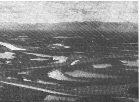
The ffrst base camp was set up at Fig. 3. A typical view of the Mackenzie River delta looking west at the Richardson
Mountains.
a potential'site approximately 12 miles southwest of Aklavik. This site was Iocated on the alluvial fans of the Richardson Mountains. The camp was located at the junction of the delta and the fans near the Husky Channel and so was called the Husky Site. The camp was set up during the beginning of April and consisted of two 16 x 16 ft. tents and some other smaller tents. All of the camp equipment was brought to this site by tractor from Aklavik.
Unfortunately the region experi-enced one of its coldest Aprils on record and this restricted much of the soil sampling. For the ffrst two weeks in camp, the temperature rarely rose above 0'F and went down at nisht to as low as -30'F. An attempi was made to drill during this interval but the problems of supplying drilling wash water soon forced its abandon-ment until air temperatures rose above 1 0 ' F .
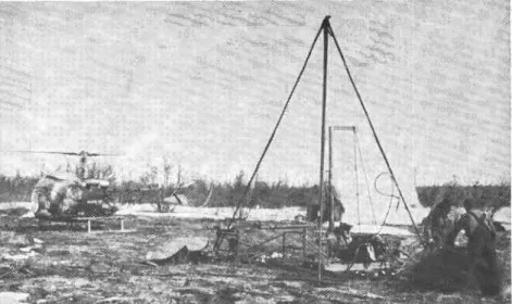
The drilling equipment used was a modified version of a permafrost drill developed by the U.S. Corps of Engi-neels (Fig. 5). It is essentially similar to a diamond drill using wash water to carry away bit cuttings, but uses a hard metal insert bit (carballog) in-stead of a diamond bit. A notable feature of the rig is that it is made of lightweight materials and can be broken down into small light com-ponents for easy transportation by bush aircraft. The special feature of drilling and sampling in permafrost is not the equipment used but the amount of wash water and the skill with which it is used. If too much wash water is fed to the face of the bit to carry away frozen soil chips, there is a danger of melting and wash-ing away the core, even though a double-tube type of core barrel is used. On the other hand. if too Iittle wash rvater is used. the frozen soil cuttings soon form a slush r.vith the wash water which can quickly freeze in the core barrel. No rules can be formulated for the amount of u'ash water to use and the correct amount is best determined in the fteld.
After the samples were obtained from the drilling, representative split cores were photographed in colour before soil samples were taken. These photographs were invaluable later when the soil test results were available and references were re-quired to the types of frozen soil en-countered. The samples were shipped to Norman Wells for routine engineer-ing soil identification tests includengineer-ing determinations of moisture content, grain size, Atterberg limits, and
' ' " 1
natural densities.
Break-up observations r.vere started during May. These consisted of estab-lishing observers at the potential town-sites to record channel water levels and to assess the damage, if any, caused by the moving ice. During the break-up interval of the delta, daily reconnaissance flights were made with the helicopter and the rate of progress of the moving ice and general water levels was observed.
After break-up, the survey party proceeded to the east side of the delta and carried out terrain studies at two potential sites known as East Threa and East Four. Two more of the east channel sites were eliminated as poten-tial townsites because of their low-lying topography and possible diffi-culties in reaching them by river transport. After the east channel sites had been invesUgated, the party com-pleted its investigations at another site on the west channel. This site was purposely left until the end of the survey since snow cover remained at this location until June and made terrain investigations difficult.
After the four ffnally selected sites had been investigated, the survey completed its ffeld reports. A pre-liminary appraisal indicated the site kno-wn as East Three to be the most favourable. Even though a ffnal de-cision on the new tormsite could not be made until the fall of the year, the need for design data from the chosen site was anticipated. Accord-ingly the month of August and part of September were spent in making a detailed terrain analysis of East Three and collecting soil samples for a better understanding of the soils at this site.
Description of New Site: East Three The central part of the eastern
lii
...
t ,
Fig. 5. Drill rig operation before airlift to next drilling location. Tent in background provides shelter for soil sampling and photographing frozen cones.
delta flank is predominantly a huge glacial moraine. In the southern part, bedrock is exposed through the glacial deposits; in the northerrr part, in the latitude of the Reindeer Station, the moraine is built up around the Cari-bou Hills. East Three is located be-tween the areas of bedrock to the south and the Caribou Hills to the north where the East Channel fows along or close to high ground of glacial origin.
The relief of the area is one of fats at varying elevations, gentle undula-tions separated by shallor.v swales, rounded knolls, hummocky hills and ridges of varying heights and lengths. To the north are two terraces at elevations of 60 and 150 ft., and to the south a series of elongated smoothly rounded hills (drumlins) aligned in an east-and-west direction, with a swing to the north as the chan-nel is approached. Some of the low-lying areas between the hills are oc-cupied by small lakes.
East Three is drained to the west and rrorthwest by streams which eman-ate from deep gullies in the high in-terior upland. The drainage is con-trolled by the relief, especially in the southern part of the area where the streams flow in parallel courses be-tween the ridges. As a rule the ridges, knolls, and undulations are well drained although some of the rela-tively lower areas are not.
Spruce and birch are the dominant tree types, with secondary stands of willow and alder. The ground is gen-erally hummocky with a varying cover of moss and shrubs. Birch predomin-ates on the south-facing slopes and on well-drained areas. Spruce predomin-ates on the north-facing slopes; stunted spmce, willow, and alder are found on more poorly drained areas.
Few trees grow on the low fat areas except along stream courses where there are dense thickets of willow and alder.
At East Three, frozen ground was encountered in September at depths varying from 6 in. to 4 ft. 3 in. below the ground surface. Surface cover of living organic material is g to g in. in depth. Soils range from fluvioglacial gravels to glacial till (stoney, silty clays with varying amounts of organic material, with the ffne-grained material deposits being of greater extent). The largest deposits of coarse-grained ma-terials (sandy gravels) are found on the northem portion of the site on the lower terrace immediatetrv. north of Boot Lake. Granular deposits are also found along the east and north banks of Twin Lake and to a lesser extent on knolls south of Boot Lake. Finer grained soils (stoney silt clays) are found in the ridges and in the Iower areas over the rest of the site area.
It must be emphasized that the new town will still be founded on permafrost. It would be impossible to ffnd any site in the delta area that was not underlain by perennially frozen material. In the development of the new townsite, therefore, every necessary precaution against disturb-ing the general permafrost condition will have to be taken. The topographi-cal relief of the nerv site, however. rvill facilitate all surface drainage ar-rangements. The glacial origin of the underlying soils rvill yield more satis-factory foundation conditions than at the old site, and should provide rea-sonable supplies of road building ma-terial and gravel. At the same time, the glacial character of the local soils almost inevitably means that some massive ground-ice (in the form of ice-boulders in the glacial till) is pres-ent beneath the site so that iome eventual ground subsidence is to be expected.
The site is a beautiful one, especi-ally in summer, and spreads over roll-ing hills that are enlivened with small lakes. From the site there is a striking view of the lowJying delta to the rvest. With the careful town planning that is intended for the new settle-ment, the Aklavik of the future should be as attractive physically as the old Aklavik was disappointing.
Conclusion
Despite all difficulties the survey team completed their main assignment by the scheduled date, their ffndings pointing to East Three as the most
de-sirable site for the new Aklavik. The third author had the privilege of visit-ing all four sites, in the company of his fellow authors and of other mem-bers of the team, in late July 1954. Two weeks later, the sites were visited by the then Minister of Northern Affairs and National Resources and by Mr. R. G. Robertson, his Deputy Minister. This is believed to be one of the first occasions when the Fed-eral Minister responsible for Northern Canada has been able to study in the field, and far to the north of the Arctic Circle, the facts upon which a major policy decision was to be based. The results of the survey were re-ported to the Advisory Committee on Northern Development, of which Mr. Robertson is the Chairman. The Com-mittee endorsed the selection of East Three as the locati,on for the new
Aklavik and on November' 18, 1954 the Federal Cabinet, upon the recom-mendation of the Minister of Northern Affairs and National Resources, of-ffcially decided that the town of Ak-lavik should be moved to this new site. Responsibility for the vast amount of work which the implementing of this decision involved is being shared by the Department of Northerrr Affairs and National Resources and the De-partment of Public Works. Preliminary planning has been done; work is ac-tively proceeding at the site. Within a few years the new town will be a reality gracing its ffne new."'location. The authors are indebted to all the members of the survey team not only for their good work in the ffeld but for demonstrating so well rvhat can be achieved by real team-work in the interests of the awakeninq North.
Appendix A
the Suruey Team Mernbers K . C . B e r r y . . R. J. E. Brown. G. H. Johnston. J. A. Pihlainen J. K. Fraser E. J. Garrett
J . w . c r a G e . . . . . . . : : . .
. : .
C. L. Merrill (Leader)Local Aklavik Advisorl' Cornmi I tee
Canon R. K. Gibson (Chairman) .
F a t h e r A . B i n a m e , O . M . I . ( S e c r e t a r y ) . . . . . Karl Gardlund Charles Smith Rev. J. Sitichinli. Inspector W. G. Fraser S. M. Peffer. . H . F i g g u r e s . . . . Representing
Department of Public Works National Research Council (D.B.R.) National Research Council (D.B.R.) National Research Council (D.B.R.) Department of Mines and Technical
Surveys (Geographical Branch) Departmeni of Trahsport
Department of National Health and Welfare
Department of Northern Affairs and National Resources
Advisory Mernbers "ex-officio"
Lieut. P. Johnson. Royal Canadian Navy-Aklavik
W. O. D. AIIison. Cairadian Armv (Sieirals)-Aklavik
Inspector W. G. Fraser. Roval Canadian Mdunted
Police-Aklavik
F. Carmichael
Anglican Mission Roman Catholic Mission Trappers
Eskimo
Loucheux Indians
Royal Canadian Mounted Police Local Traders
Local Traders
Territorial Government
Department of Northern Affairs and National Resources (Local Ad-ministration)
L. B. Post
Appendix B
Suruey Costs
Staff salaries.
Personnel transport: Ottawa to Aklavik (Return) Edmonton to Aklavik (Return) Rations (Purchased locally: 1440 man days at $3 a day). .
flelicopter service Labour (local)
ServicesServices (local) Rental of equion
Rentat of equipment (loeal). . . .
Camp fuel, 615 gallons heating oil at $0.26 . .gallons heating oil at $0.26 1277 gallons at $0.34.. Fuel for boahs, 1277 gallons at, $0.34.. Oil for boats, 55 qallons at $2.50 . .. Oil for boats,Oil for boats, 55 gallons at $2.50 Freight for initial camp, 3,000 lb
! rerght tor rnltral camp, J rreilht for drill rig;, il60d
$13,000 3,500 4,32O 20,000 2,857 468 l,2oo r60 434 r37 3,630 2,000 +N.R.C. propeily w no rcntal chu4w $51,706
.,F E
A list of all publications of the Division of Buildine Research is avail-able and may be obtained from the Publications Section, biuisiotr of Building Research, National Research Council, Ottawa. Canada.