Publisher’s version / Version de l'éditeur:
Technical Translation (National Research Council of Canada), 1965
READ THESE TERMS AND CONDITIONS CAREFULLY BEFORE USING THIS WEBSITE.
https://nrc-publications.canada.ca/eng/copyright
Vous avez des questions? Nous pouvons vous aider. Pour communiquer directement avec un auteur, consultez la
première page de la revue dans laquelle son article a été publié afin de trouver ses coordonnées. Si vous n’arrivez pas à les repérer, communiquez avec nous à [email protected].
Questions? Contact the NRC Publications Archive team at
[email protected]. If you wish to email the authors directly, please see the first page of the publication for their contact information.
NRC Publications Archive
Archives des publications du CNRC
For the publisher’s version, please access the DOI link below./ Pour consulter la version de l’éditeur, utilisez le lien DOI ci-dessous.
https://doi.org/10.4224/20331559
Access and use of this website and the material on it are subject to the Terms and Conditions set forth at
Instructions on Engineering Surveys for Municipal and Settlement
Construction (SN 211-62)
Kos'kov, B. I.; Nalivkin, A. N.
https://publications-cnrc.canada.ca/fra/droits
L’accès à ce site Web et l’utilisation de son contenu sont assujettis aux conditions présentées dans le site LISEZ CES CONDITIONS ATTENTIVEMENT AVANT D’UTILISER CE SITE WEB.
NRC Publications Record / Notice d'Archives des publications de CNRC: https://nrc-publications.canada.ca/eng/view/object/?id=d94b0668-3516-4060-8c5f-d4c4baf0c3a2 https://publications-cnrc.canada.ca/fra/voir/objet/?id=d94b0668-3516-4060-8c5f-d4c4baf0c3a2
The Division of BUilding Research is naturally interested in all the preliminary work that must be done in connection with the extension of municipal areas and the development of new settlements. Correspondingly the Division has keen interest in the recording of local ground conditions in urban areas, a study that is already given the title "urban geology".
In the course of worldwide inquiries as to practice in this field in other countries, the Division was privileged to be
adVised, through the good offices of the Canadian Embassy in Moscow, of the existence of a notable Soviet publication of which this is a translation. It is an official publication of the State Committee of the Council of Ministers of the USSR for Construction. It was published in Moscow in 1962 having been prepared by the Moscow City Geotrust of the Chief Architectural Planning Directorate in cooper-ation with Gosstroi.
The documents will be found to be a most comprehensive "check list" of the many physical factors that must be considered in connection with good city planning and city development. The Division is privileged to have this translation published in its series of technical translations since it seems clear that the
document can be of wide use in connection with city planning work in Canada.
The Division is indebted to Mr. H.R. Hayes for the translation. Ottawa
August 1965
Robert F. Legget Director
NATIONAL RESEARCH COUNCIL OF CANADA
Technical Translation 1206
Title: Instructions on engineering surveys for municipal and settlement construction (SN 211-62)
(Instruktsiya po inzhenernym izyskaniyam dlya gorodskogo i poselkogo stroitel'stva - CH 211-62)
Official publication of the State Committee of the Council of Ministers U.S.S.R. for Construction
Editors: B.I. Kos'kov and A.N. Nalivkin
PUblisher: Gosizdat. Lit. po Stroitel'stvu, Arkhltekture i Stroitel'nym Materialam. Moskva, 1962
(State PUblishing House of Literature on Construction, Architecture and Building Materials. Moscow, 1962)
1. The Russian word "gorod" (town or city) and its adjectival form "gorodskii" have been translated as "municipality" and Bュオョゥ」ゥー。ャBセ
respectively. Broadly defined as a populated place of commercial and industrial significance, usually a trading, administrative and cultural centre, a "gorod" was more specifically defined in 1958, according to R. E. F. Smith's Russian-EngliSh Dictionary of Social Science Terms (1962), as follows: in the R.S.F.S.R., a locality with not less than 12,000 population, of which not less than 85% are manual or office workers, or members of their families; in the Ukraine the minimum number is 10,000, and in other republics it appears to be 5,000.
2. Types of settlements distinguished in Soviet sources are: (i) dachnyi poselok - estate of summer cottages,
(ii) kurortnyi poselok - health resort,
(iii) rabochii poselok - workers' settlement or housing estate, (iv) poselok gorodskogo tipa - urban-type community (in which
majority of population is employed other than in agricul ture ) •
Surveys for Surveys for Surveys for Surveys for TABLE OF CONTENTS Page 1. SURVEYS FOR PLANNING LAYOUT AND LOCATION PLAN FOR TOP PRIORITY
CONSTRUCTION
Economic Surveys (No. 1.01 - 1.21) 6
Technical Surveys (No.2. 01 - 2.235) ...•..••...•... 12
Composition of technical surveys ...•..•...•.... 12
Topographic and geodetic work ...•...••. 13
Engineering geology work.... ..•.•... .••... 14
Engineering geology survey. .•.. .•. .•.. 17
Geophys ica 1 work ...•... 22
Engineering geology excavations ...•...•... 22
Experimental field work 24 Stationary observations ...•.. 24
Laboratory investigations ....•..••..•... 28
Engineering Geology Work in Special Conditions (Additional Requirements) Investigations in permafrost regions ....•...•..••... 29
Investigations in karst regions 30 Investigations in mining regions .•••... 31
Investigations in earthquake regions ...•... 32
Investigations in landslide regions ....••. .•..•... ...• 33
Investigations in regions of ground settlement •...•....•... 33
Investigations in regions where certain soils occur (saline, alkaline, etc.) •...•...•... 34
Investigations on the shores of seas, lakes and the banks of reservoirs 34 Investigations in swampy areas ...••. 36
Investigations in regions where rock and partially formed rock occur 37 Investigations in upland and alpine regions ..•.•...•.... 37
Office Processing of Survey Material... 38
Corrosion Investigations ...•.•...•...•...•..••..•.. 40
Hydro logical 'Hork .•...•..•...•...•...•• 42
Climatological l'lork •..••....•...•...••...•.•••..•..•.•... 44
S011 Surveys . . . • . . . . 45
Geobotanlcal Work 46 Heal th Surveys 47 Surveys for Engineering Systems and Utilities, Transport and the Engineering Preparation of the Area .•.•...•...•••.••.•....••••.. 54
Engineering systems, utilities and transport ....•...•..•. 54
Engineering preparation of the area ..••...•...••••••..••... 55
Vertical planning ...•...•••..•.•...•.. 56
Organization of Economic Development of Area ...•...•.•... 56
Tree and Shrub Plantation Schemes ••.••...••...•...•.• 57
Construction Materials ...•.••.•..•.•.•...•. 57
II. SURVEYS FOR DETAILED PLANNING
Economic Surveys (No. 3.01 - 3.09) 60
Technical Surveys (No. 4.01 - 4.09) 61
III. SURVEYS FOR BUILDING LAYOUT A. Surveys for Planning Programme
Economic Surveys (No. 5.01 - 5.02) 64
Technical Surveys (No. 6.01 - 6.32) •..•. ...•.•... ...•... 64
Topographic and geodetic work ...•..•...•... 64
Engineering geology work... ..•.. 65
Investigations for vertical planning of sub-districts, blocks, streets and squares .. ...• 65
Surveys for tree and shrub plantation ...•.. 65
Surveys for construction organization plan ...•..•... 67
Hydrological, Climate, Soil, Geobotanical and Health Surveys .•.. 69
B. Surveys for Working Drawings Technical Surveys (No.7. 01 - 7.09) .••...•..•...•... 69
Topographic and geodetic work ...•...•.•..•... 69
Engineering geology work ..•. .••. ..•••...•.• .•.•..• ...•. 70
Surveys for vertical planning •••.•.. ...••...•...•.•... 70
Surveys for construction of water supply, sewer, power supply and communications systems and structures •••.••..• 70
C. Engineering Geology Surveys for Construction Plans of Individual Buildings and Special Structures Engineering geology work for individual buildings and structures 71 Engineering geology work for special structures ••...•.•....
75
D. Survey Work Related to Investigation of Existing Buildings (No. 9.01 - 9.24) Investigations of SUbsurface Elements of BUildings •...•.••.. 91
Investigations of Superstructures of Buildings .. .•••...•.. 93 Construction Site Registration Document 96
State Committee of the Council of Ministers U.S.S.R. for Construction Building Standards mSTRUCTIONS ON ENGINEERlliG
SURVEYS FOR MUNICIPAL AND SETTLEMENT CONSTRUCTION
SN 211-62
The Instructions on Engineering Surveys for Municipal and Settlement Construction were developed by the Moscow City Trust of the Geological, Geodetic and セュー Service of the Executive Committee of the Moscow City Soviet of Workers' Deputies (Mosgor-geotrest) of the Chief Architectural and Planning Directorate of the City of Moscow with the participation of the State Institute for City Planning (Giprogor) of the State Committee on Construc-tion and Architecture of the Council of Ministers of the R.S.F.S.R. (Gosstroi RSFSR).
1. SURVEYS FOR PLANNING LAYOUT AND LOCATION PLAN FOR TOP PRIORrrY CONSTRUCTION
Economic Surveys (No. 1.01 - 1.21)
1.01. The principal aim of economic surveys in developing the planning layout and the location plan for top priority construction is the study of materials and the collection of data and information required for:
determining the prospects for the growth of the urban development branches of the municipality's (settlement's) economy and population increase;
determining the size of land areas for individual functional zones of the municipality (settlement) and of reserve areas for them, also the most effec-tive distribution of these zones and reserve land areas;
determining the approximate volume and the most effective allocation of primary construction;
determining the most economical types of dwelling for a given municipality (settlement).
1.02. For a solution of the economic problems relating to the planning layout referred to in para. 1.01 it is necessary to assemble the data on the history of the municipality's development; the population; the growth level of industry and plants under construction; rail, water, air and road transport; the high school and special secondary educational establishments; the institu-tions and enterprises providing services; urban housing and land allocainstitu-tions; housing construction and the construction base; and, in addition, data on the surrounding region.
Approved by the State Committee of the Council of
1.03. In conducting economic surveys for the location plan for top priority construction, the economic survey data for the planning layout are used with the required adjustments and additions.
1.04. Economic surveys for the planning of new municipalities (settle-ments) consist mainly of determining the prospects of developing industry and plant construction and the feasibility of utilizing the land for the future municipality (Bettlement) and its top priority constructicn areas.
The form of the economic surveys may be determined more precisely, depending on the specific conditions of the projected municipality
(settlement).
1.05. The statistical data required for the municipality (settlement) planning layout and the location plan for top priority construction are taken from January 1 of the year in which the survey work is conducted.
1.06. In order to study the special features of the present state of the municipality (settlement) it is necessary to know the history of its origin and development. For this purpose, information should be sought relating to the period in which the municipality (settlement) was founded and the factors which gave rise to its origin; its popUlation; the economic, cultural and administrative importance of the municipality (settlement); the construction of large-scale industrial plants, power installations, transport systems; the boundaries; the size of the land area; the building, planning and provision of public services and welfare for the main periods and stages of the development of the municipality (settlement); and, in addition, the ョセウエ important archi-tectural and historical monuments and the principal changes in the structure of the municipal plan.
1.07. The size and composition of the population are the most important factors which determine the prospects of a municipality's development. There-fore, in order to determine the planning layout it is necessary to assemble the data on the population strength of the whole municipality and its distri-bution by urban districts; the natural population increase and the influx of residents from outside during past years; the composition of the population by age group3 (day nursery, pre-school, school, available for work, pensioned); the numbers of workers in industry, construction, transport, and in institu-tions and organizainstitu-tions of significance for urhan development; and, in addi-tion, the numbers of students in all the high school and special secondary educational establishments.
1.08.
In
order to obtain the industrial growth level characteristics, the existing industrial areas and those under development ウィッセャ、 be studied in conjunction with the municipality's largest plants. The following data on the plants should be collected: the sizes and locations of industrial sites;
-8-natural conditions and open spaces; main types of products and number of workers; level of labour productivity; production and technological connec-tions (collaboration) with other enterprises; water supply, sewage and power supply conditions; the freight turnover and transport facilities; the areas reserved for housing. In addition, the plans of recently constructed plants and the reconstruction plans for existing plants should be studied, as should the decisions and conclusions of the above-mentioned organizations relating to the operational conditions of the plants.
1.09. For industrial growth level characteristics the following should also be studied:
local raw material resources, i.e. the industrial reserves of individual types of minerals in the municipality and surrounding region, and, in
particular, the reserves of construction materials, the output in recent years and the extent of their utilization by the municipality's industrial plants and operational conditions;
fuel and power resources of the municipality and its surrounding region: petroleum, gas, coal, and peat deposits, their location, industrial reserves, their output in recent years and the extent of their utilization by the
municipality's industrial plants; power station, high voltage grids, their capacity and the extent of their utilization by the municipality's industrial plants;
rail, water and road communications which are of importance in the industrial development of the municipality and its surrounding region.
1.10. Data on small enterprises should include the numerical strength of the work force and the main types of output.
1.11. Data on the volume of completed work for the year under review (freight and passenger turnover, etc.) and the numerical strength of the work force should be ascertained for all types of rail, water, air and road trans-port installations, plants and organizations.
1.12. For high school and special secondary educational establishments it is necessary to have the data on the numbers of stUdents, teaching staff, and maintenance personnel, the cubic content of occupied buildings and the dimensions of the lots and the prospects of reconstructing and building new high school and special secondary educational establishments.
1.13. Information on the numerical strength of the work force, the dimensions of the plots of land and the cubic content of occupied buildings should be assembled for every institution and organization outside the munici-pality which is of importance in urban development: administrative and public institutions, court and procuratorship bodies; central institutions and
museums; publishing houses; newspaper editorial offices, and other cultural and educational organizations; likewise, district hospitals, sanatoria, rest homes and agricultural enterprises whose workers live permanently on municipal land.
In
addition to this, information must be gathered on the proposed organi-zation of new institutions of ウゥァョゥヲゥセ。ョ」・ outside the municipality, thenumber of workers and the cubic content of projected buildings or buildings under construction for them.
1.14. The following data should be collected on institutions and enter-prises requiring maintenance services (schools, kindergartens, day nurseries, movie theatres, baths, etc.): the number of institutions and enterprises; the number of people they hold; the total cubic content of the bUildings in which they are housed; the number of places per one thousand inhabitants.
It is necessary to obtain the following data on each of the largest
service institutions for which a sizeable plot of land is required (hospitals, rinks, stadiums, etc.): the dimensions of the plots of land; the number of people the buildings will hold; the volume and area of the bUildings; separate
consideration being given to those which, by reason of their technical condi-tion, are liable for replacement.
In
addition, the prospects of constructing new buildings for these institutions should be determined.1.15. The status of the urban housing reserve areas should be studied to determine the amount of new housing construction and to resolve municipal planning questions. For this it is necessary to ascertain the following
information about the housing reserve areas:
the availability of these areas and their allocation for houses according to the number of storeys and wall material; the replacement value and the
actual value of the housing reserve areas, separate consideration being given to houses which are privately owned;
the amount of living space in barracks and buildings in a state of disrepair with indications of the blocks in which these bUildings are prin-cipally located;
the amount of living space in buildings that have sustained considerable deterioration, with indications of the areas of the town in which these
buildings are principally located, the year of construction, the average per-centage of deterioration, and the average actual value of one square metre of living space;
the amount of living space in zones where there are health hazards from industrial plants and other installations, with indications of the number of houses the number of storeys they possess and the materials of which their walls are constructed;
-10-the extent to which -10-the population is provided with living space (per inhabitant).
For municipalities divided into urban districts the housing reserve indicators should be worked out not only for the municipality as a whole, but also for each separate district.
The housing reserve data are worked out from material in the files of the urban inventory office and the local agencies of the Central Administra-tion for Statistics (TsSU) as well as from examinaAdministra-tions of the dwellings themselves.
1.16. A study of the data on the land reserves of the municipality (set-tlement) is necessary for defining in planning layouts the future course of land development. In studying the municipality's land reserves, the area and location of the developed functional zones (residential, industrial, ware-house, etc.) and the individual functional elements located outside the boundaries of the corresponding zones should be determined.
At the same time, it is necessary to ascertain the size of vacant tracts of land suitable for subsequent urban construction situated both in the
built-up areas (waste land) and outside them (agricultural and waste land, etc. ).
1.17. One of the main tasks in formUlating the economic basis for plan-ning layouts is the determination of the dimensions and location of top-priority housing, social amenities and public construction. In order to accomplish this it is necessary to collect the data for the past 2 -
3
years on the characteristic dimensions and the location of eXisting government, cooperative and individual housing construction; the disposition of these buildings according to numbers of storeys and wall material; the cost of state housing construction, separate consideration being given to the cost of the work on the pUblic services within the block.In the case of indiVidual construction, additional details are required on the number of claims for allocation received and the plots of land actually allocated, their average size and the average amount of liVing space per
house.
Besides this, the following should be ascertained:
the amount of new housing construction planned for the next
5 -
10 years; the size of the combined living space and the number of storeys in houses situated on new sites and in blocks under reconstruction, together withdetails of the number of storeys and the amount of living space in the demolished houses;
the reasons for deviating from the amount of housing construction
stipulated in the plan, the disposition of the buildings according to number of storeys, location and cost;
a list of the social amenities and public servicing organizations, con-struction for which is scheduled in the next
5 -
10 years and construction which has been completed in the past 2 - 3 years, together with the basic completion figures and the cubic content of the bUildings;the planned capital investment for the next 5 - 10 years in housing, social amenities and public construction and details of implementations in past years;
the cost of one square metre of new living space, the expeditures on newly developed sites being listed separately.
1.18. In order to be able to resolve questions relating to the future development of the construction base it is necessary to study the output
capacity of existing construction organizations and plants of the construction materials industry.
For this purpose, information should be obtained about the municipality's construction organizations relating to the volume of construction and
assembly work being carried out, details of housing, Bocial amenities and public construction being treated separately; the numerical strength of the work force and the amount of technical equipment.
The output capacities of construction materials industry plants should be determined, distinction being made between prefabricated reinforced con-crete plants and house construction combines.
1.19. In order to determine the mutual economic, transport, domestic and other links between the municipality and its Burroundings, in conformity with the specificiations of the planning layout, the following should be
ascertained:
existing populated places (their population, main branches of activity, number of people working in the municipality, transport links with the
municipality, amount of housing reserve, predominant types of building, etc.); large industrial plants (output and number of workers);
commercial minerals of the area (reserves of individual deposits and their utilization by industry);
large power installations (capacity and routes of high-voltage transmis-sion lines and gas pipelines);
large rail, water, road and air transport installations (their handling capacity and routes);
resort and country places (recreational sites for the townspeople,
sanatoria, rest homes and pioneer camps which serve the municipality, together with the number of people each bUilding will accommodate, cubic content of the building and sizes of plots of land);
-12-forest lands and parks (tree varieties, density, rate of growth, possibilities of utilizing them for the needs of the municipality);
collective and state farms (specialized fields of these establishments, structure and sizes of the areas under crops);
reservations, their importance and condition;
land areas suitable for future expansion of the municipality's functional zones and for construction of various objects and installations which it would be advisable to locate outside the town limits.
The dinlensions of land areas occupied by the enUTIlerated objects in the regions adjacent to the municipality and the distances between these objects and the municipality should be ascertained.
In studying the regions surrounding large municipalities, it is necessary to determine the areas which are suitable for the construction of satellite municipalities.
1.20. An explanatory report and graph data are compiled as a result of these economic surveys for セィ・ planning layout and the location plan for top priority construction.
1.21. The economic survey data and the conclusions and proposals are given in the explanatory report.
The chart material consists of: a key plan of the town to a scale of 1 : 5,000 or 1 : 10,000; a diagram of the present areas of settlement showing plants and establishments, the nUTIlbers of workers, residential areas and population figures (compiled only for large municipalities and shown on a blueprint of the key plan of the municipality), a cartogram of the housing reserve density showing the delapidated and low-value blocks, and a 1 : 25,000 to 1 : 50,000 scale map of the region surrounding the municipality.
Technical Surveys (No. 2.01 - 2.233) Composition of technical surveys
2.01. The technical surveys are made up of: topographic-geodetic investigations; engineering geology investigations; corrosion investigation;
hydrological investigations; climatological investigation; soil investigations;
geobotanical investigations; sanitation and hygiene surveys;
surveys of engineering services and utilities, transport and the engineering preparation of the area;
surveys for the formulation of tree and shrub planting schemes; work on surveys of construction materials;
surveys for the formulation of a construction organization plan.
The technical survey structure may be defined more precisely depending on the available survey data.
!opographic and geodetic work
2.02. Before compiling topographic charts for use in the design and planning work, the available geodetic material (originals or copies) should be collected, studied and evaluated for adaptability to, and conformity with, the current state of the topography and building, and the municipality's engineering equipment. The evaluation of the degree of adaptibility of the available geodetic and aerial survey data is prepared in the form of official documents.
2.03. A cartogram of the surveys covering the municipality and surround-ing area is compiled from the results of the study of the assembled topograph-ic, geodetic and aerial photo survey data. The scale of the photo survey and the year in which it was produced should be indicated. Charts of the existing reference systems (triangulation, polygonometry and levelling) are attached to the cartogram.
2.04. The topographic and geodetic work involves: planimetric and con-tour mapping of urban land (triangulation, po lygonome try, levelling and theodolite traverses);
surveying (air photo, plane table and tacheometric surveys) and compila-tion and reproduccompila-tion of charts and maps to scales of 1 : 5,000 tol : 25,000. 2.05. AI: 5,000 scale topographic chart is used in the compilation of a master plan when determining the planning layout for a municipality or settlement. For the compilation of a master plan in the planning of large municipalities it is permissible to use a 1 : 10,000 scale topographic chart, and for small settlements, a 1 : 2,000 topographic chart.
2.06. The topographic char-t used as a basis must reflect the layout of the district, all types of bUildings with descriptions of wall material and number of storeys (excluding uninhabited wooden buildings) and the relief of the area in contour lines at the time the master plan of the municipality was drawn up.
2.07. Also shown on the topographic chart are all the elements of exist-ing plans, bUildexist-ing and engineerexist-ing facilities, the principal inherent factors which restrict building (transport installations, swamps, mines, etc.); trees and shrubs (parks, squares, boulevards and gardens); historical and architec-tural monuments and buildings; urban areas, streets and thoroughfares and their surfaces (a distinction is made in the case of improved types of surfaces) .
-14-2.08. The map of the surroW1ding area of the mW1icipality is drawn to a scale of 1 : 25,000. For this it is permissible to use a smaller scale map enlarged to the required scale.
2.09. On the map of the surrounding area of the mW1icipality is ウィッセュZ municipality centre and building areas;
main higjlways;
municipality limits and principal land development areas;
all populated places, country Villages, sanatoria, rest homes, pioneer camps, main roads, parks, forest parks, reservations, nurseries, reservoirs, physical cultural centres, etc.;
plants of the extractive, manufacturing and power industries, tracts of land and principal installations belonging to rail, water and air transport services, railway stations, quays and high voltage transmission lines;
water supply installations and water protection areas, sewage outlets, land occupied by sewage purification plants, animal burial grounds, motor haulage roads, high voltage lines, and other utilities which exist outside urban bUilding area.
2.10. Maps to a scale of 1 : 5,000 to 1 : 10,000 are used for the presen-tation of graphic data which characterize the natural conditions of the area and the municipality engineering facilities. Smaller scale maps may be used.
2.11. Photographic maps and charts and individual photographs are used to illustrate the completed planning layouts and the top priority construction layouts (plans).
Engineering geology work
2.12. The engineering geology work undertaken for the municipality (settlement) planning layout must provide the necessary solutions to the questions of the engineering value of the land and the distribution of all kinds of building regardless of the constructional characteristics of the individual buildings and structures.
2.13. The amount of work depends on the nature of the construction, the areas of investigation, the degree of complexity of the geological structure and the hydrogeological conditions, the intensity of the physical and geologi-cal effects, the extent to which the area has been surveyed, etc.
2.14. The data obtained as a result of investigations should include in the fullest and broadest terms:
general information on the topography, hydrology, climate, soils and vegetation;
description of the @eological structure (stratigraphy, mode of occurrence of rocks, tectonics, etc.);
characteristics of the hydrogeological conditions of the area (depth of occurrence of groundwater and its direction of movement, chemical affinity, regime, etc.);
description of the morphology, physical and geological phenomena and specific conditions which influence general reliability of area (karst, landslides, subs fdence , liability to ea r-thquake s , permafrost, etc.);
description of properties, structure and condition of soils with an evaluation in terms of operational ウエ。ョ、。イ、セ based on field tests and laboratory research;
conclusion as to general condition of area under development and its zoning for engineering geology purposes from the point of view of utilization for construction;
necessary maps and other graphic and tabular data.
2.15. To provide a basis for the planning layout of the suburban areas of large municipalities, an engineering geology survey of the locality is carried out and the evaluations shown on 1 : 25,000 to 1 : 50,000 scale maps, using the data of previously conducted investigations.
2.16. The engineering geology survey work is divided into three phases: preparatory, field and laboratory.
2.17. In the preparatory phase, work is carried out on the preparation and layout of the survey, the collection and analysis of survey data for past years and the compilation of a survey programme.
2.18. The survey assignment should include: a contour map of the pro-jected municipality (settlement) to a scale of 1 : 5,000 to 1 : 25,000, each top priority construction sector being given separately and, for large
municipalities, additional maps to a scale of 1 : 25,000 to 1 : 50,000 showing the suburban boundaries; the approximate specifications of the types of'
buildings and structures scheduled for construction; a feasible layout plan for the variously designated sectors on 1 : 10,000 to 1 : 50,000 scale maps and the dates of submission of the data.
2.19. The purpose of collecting and analyzing past survey and other
necessary material is to obtain information about the characteristic nature of the climate of the area, the hydrographic system, topography, geological
structure, tectonics, geomorphology, physical and geological phenomena, hydro-geological conditions, physical and engineering properties of the Boils, and to determine the availability of construction materials.
Special attention should be given to the collection of information about the deformation of existing structures and the related causes at sites where construction work has been carried out.
-16-2.20. Using the collected and analyzed data, maps are made of the
geological, hydrogeological and engineering geology studies showing the nature and purpose of the work carried out earlier, the scale of the work and the extent of the investigations, the organization which carried out the survey, the inspection, the executive officers, the time the work was carried out and the place where the papers are kept, the locations of test boreholes,
exposures, etc.
The formulation of individual kinds of map coverage and their scales depends on the collected material available. The plotting of factual data from maps of a smaller scale than that of the map coverage being formulated is permissible in exceptional cases together with an appropriate footnote.
2.21. When there is sufficient survey data from previous years, the investigations for the municipality (settlement) planning layout may be
ャセエ・、 to a reconnaissance inspection of the sector by a geologist, and,
where necessary, the drilling of additional proving holes to clarify the existing engineering geology data.
2.22. The programme of research work must include: a statement on the specific purpose of the work and a list of the data used, a brief natural and historical description of the area, a programme of the work to be carried out with reasons for the volume of work and the time it will take for completion and a list of the report data used.
A map showing the locations of the planned engineering geology test bore-holes and a work completion chart should be attached to the programme.
2.23. The organizations carrying out the engineering geology investiga-tions are responsible for the standard of work, and for the technical and economic expediency of the operations.
2.24. Before making a start on the field work, the area is reconnoitred to determine the degree of complexity of the individual sectors to decide on the direction of the main borehole cross-sections, to establish areas for experimental work and stationary observations, etc. A preliminary survey of the suburban area will yield the basic data on the geological structure, geomorphology and hydrogeology required for the planning layout of the suburban area. These data are plotted on a 1 : 25,000 to 1 : 50,000 scale map.
2.25. As a rule, the following types of work are conducted during the field phase: engineering geology surveying, geophysical work, engineering geology excavations (boreholes, test pits, etc.), experimental field work, stationary observations, laboratory work, and engineering geology work under special conditions.
Engineering geology survey
2.26. The chief purpose of the engineering geology survey is to ascertain the overall geological structure, geomorphology, hydrology, tectonics, and focuses of physical geological processes. The survey is made to a scale of 1 : 5,000 to 1 : 25,000, depending on the degree of complexity of the geologi-cal structure, the size of the area and the work assignments.
2.27. The engineering geology survey includes the following: study and description of natural and artificial rock outcrops,
geoDlorphological elements and physical geological phenomena plus necessary samples;
description of terrain on route between observation points; study and description of indications of presence of water;
determination of points of location of: engineering geology excavations, and places where experimental, geophysical and other work is to be carried out;
collection of rock and water samples for laboratory examination; investigation of eXisting engineering structures;
investigation and preliminary evaluation of deposits of local construc-tion materials;
photographing of control objects;
keeping of diary and draWing of field maps; current office processing of data.
2.28. The engineering geology survey is accompanied by aerogeological, geophysical, rock cutting, drilling, experimental and laboratory work in connection with which the correlation between the engineering geology survey and the other types of work varies, depending on the degree of rock outcrop-ping in the area, its size and the complexity of the engineering geology conditions.
2.29. To determine the volume of investigation work it is necessary to proceed from the degree of complexity of: (1) the geological structure,
(2) geomorphology, (3) hydrogeology, (4) the physical geological phenomena, (5) degree of rock outcropping in the area and, (6) availability of survey data of previous years.
To evaluate the degree of complexity of the engineering geology condi-tions for survey work in terms of the first four factors, the following point system is used: Category Category Category I I I . I I I . • total points
4
. . total points from
5
to8
. . total points from 9 to 12
2.30. The degree of complexity of the geological structure is evaluated according to the conditions given in Table I.
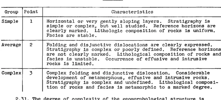
-18-Table I
Group Point Characteristics
Simple 1 Horizontal or very gently sloping layers. Stratigraphy is simple or complex, but well studied. Reference horizons are clearly marked. Lithologic composition of rocks is uniform. Facies are stable.
Average 2 Folding and disjunctive dislocations are clearly expressed. Stratigraphy is 」ッョセャ・ク or poorly defined. Reference horizons are not clearly marked. Lithological composition of rocks and facies is unstable. Occurrence of effusive and intrusive rocks is limited.
Complex 3 Complex folding and disjunctive dislocation. Considerable development of metamorphous, effusive and intrusive rocks. Stratigraphy is complex and undefined. Lithological composi-tion of rocks and facies is metamorphic to a marked degree. 2.31. The degree of complexity of the geomorphological structure is evaluated according to the conditions given in Table II.
Table II
Group Point Characteristics
Simple I Ablation or ash forms of relief. Erosion-accumulative forms of relief well marked and easily mapped.
Average 2 Erosion-accumulative forms of relief with numerous or poorly defined terraces. Development of glacial forms of relief in watershed areas.
ComPlexl 3 Glacial, mountainous or submontane forms of relief predominate 2.32. The degree of complexity of the hydrological conditions is
evaluated according to the data given in Table III. Table III
Group Point Simple I
Average 2
Characteristics
Stratified water-bearing horizons of constant extent and
thickness predominate. Groundwater is confined lithologically to bedrock layers of one type, to alluvial deposits, blanket clay loams, etc. Groundwater is of a uniform chemical compo-sition.
Stratified water-bearing horizons predominate which are not consistent either in extent or thickness. Groundwater is con-fined to uniform massive-crystalline rocks, to facially meta-morphic layers of bedrock, to a complex of glacial deposits, to debris cones, etc. Groundwater is not of a uniform chemical
Table III - continued Group Point
Complex 3
Characteristics
Different types of groundwater with complex interrelationship. Karst water. Groundwater in permafrost region.
2.33. The degree of cOlnplexity of the physical geological phenomena is evaluated according to the data given in Table IV.
Table IV
Group Point Characteristics
Simple 1 Absence of clearly defined physical geological phenomena
affecting engineering geology evaluation of area and water-bearing properties of soils.
Average 2 Clearly defined physical geological phenomena (karst, land-slides, subsidences, bog formation, etc.) are evident in limited areas. Continuous formation of perennially frozen ground.
Complex 3 Physical geological phenomena occur extensively. Regions occur in which islands of perennially frozen ground are forming.
2.34. The region is divided into categories of complexity according to the degree of rock outcropping on the basis of the following conditions:
Category I - areas with good outcropping. Outcrops occur frequently both within confines of river valleys and on watersheds.
Category II - areas with fair outcropping. Outcrops are confined to individual forms of relief (valley slopes or watersheds).
Category III - areas with poor outcropping. Outcrops occur very rarely. 2.35. The average number of observation points per square kilometre of the area being mapped based on the calculation given in Table V is used to estimate the degree of detail of the engineering geology survey.
Table V
Category of Scale of survey
complexity
1 : 50,000 1 : 25,000 1
.
.
10,000 1.
.
5,000I 0.55 2.23 13.8 47
II 0.69 2.79 17.3 59
-20-2.36. The follo\11ng come under the hending of observation points in the engineering geology survey;
description of natural or artificial rock outcrops in their original mode of occurrence on the basis of which it is possible to relate rock or rock series to a particular stratigraphic or genetic classification;
description of topographic elements which will permit jUdgement of their origin and interrelationship;
description of ョセョゥヲ・ウエ。エゥッョウ of physical geological processes (land-slides, karst, subsidence, ravine formation, swamp, permafrost, undermining, etc. )j
description of natural discharges or artificial tapping of groundwater (wells, boreholes, springs, etc.) which will permit judgement of depth of occurrence of various water-bearing horizons, their connection with geomorph-ological elements, etc.j
description of 、・ヲッイセエゥッョ of engineering structures and of state of development of area.
Explanatory notes. (1) The combined description of two, three or more different observation elements is taken into consideration for two, three or more items if these observations are used in the compilation of maps. (2) The number of descriptions of engineering structures and the state of development of the area should comprise, in the built-up sectors, approximately
5 -
10%
of the total number of observation items.2.37.
The allocation of observation items according to the area beingsurveyed should be uniform in sectors of Category I complexity and have good rock outcropping. In the remaining cases the observation items are concentrat-ed in the more complex sectors of the topographic map and spacconcentrat-ed out in the simple ones.
2.38.
The amount of rock-cutting and drilling involved in the survey isgoverned by the scale of the survey, the engineering geology category of complexity and the degree of outcropping in the area.
The approximate percentage of the number of required engineering geology investigations (boreholes, test pits, etc.) involved in the survey to the total number of observation points is given in Table VI.
Table VI
Poor outcropping Good outcropping
Category of
complexity 1
.
.
1.
.
1.
.
1.
.
1.
.
1.
.
1.
.
1.
.
50,000 25,000 10,000 5,000 50,000 25,000 10,000 5,000I 4.5
6
40 50 1.5 2 15 20Table VI - continued
Poor outcropping Good outcropping
Category of
complexity 1
.
.
1 : 1 : 1.
.
1 : 1.
.
1 : 1.
.
50,000 25,000 10,000 5,000 50,000 25,000 10,000 5,000
II 10 15 45 55 5 10 20 30
III 20 30 50 60 10 15 25 40
2.39. In those instances where the groundwater is near the surface and will occur within effective range of the planned structures, it is necessary that the number of observation points for the groundwater should comprise the approximate percentage (shown in Table VII) of the total number of observation points being documented during the engineering geology survey.
Table VII Scale of survey Category of complexity 1
.
.
50,000 1.
.
25,000 1 : 10,000 1 : 5,000 I 5 20 40 50 II 10 25 45 55 III 20 30 50 602.40. As a result of the engineering geology survey of the area under investigation, the following sectors are distinguished:
sectors completely suitable for construction;
sectors conditionally suitable, i.e. those in which construction is permissible after certain engineering precautions have been put into effect, or if certain limitations with regard to form and mode of utilizing area are observed;
sectors unsuitable for construction because of certain natural conditione which threaten stability and normal operation of structures or utilization of the area. Development of such sectors calls for complex and costly land engineering work.
2.41. The ヲッャャッキセョァ field maps are compiled during the engineering geology ウオイカセケZ factual data map, geomorphological map combined with map of Quaternary セ・ーッウゥエウL ァ・ッャッセゥ」。ャ map of bedrock, and hydrogeological map.
Explanatory note. The bedrock and hydrogeological maps are compiled in those instances where the bedrock and groundwater lie within effective range of the planned building structures.
-22-2.42. Aerogeological work supplements and facilitates the ground
engineering geology survey, and permits the achievement of greater accuracy in map compilation.
Aerial reconnaissance observations make it possible to obtain within a short time a sufficiently complete picture of the surface relief, the nature of the outcropping and the constructional elements of the geological structure; areas manifesting intensive development of physical and geological phenomena are displayed; this method also makes it possible to mark out the ground routes correctly and to investigate a large number of objects in flights at various altitudes (at different scales and exposures).
Extensive use should be made of aerogeological work together with exist-ing aerial reconnaissance data.
Geophysical work
2.43. In conducting engineering geology investigations, maximum use should be made of geophysical survey methods (electric, magnetic, seismic and gravimetric surveys; investigations involving the use of radioactive isotopes, etc.) which substantially reduce the amount of drilling, experimental and laboratory work.
The following investigations are carried out by the @eophysical method; study of geological structure, location and tracing of tectonic fault zones, fissured and karst rock areas, buried valleys, etc.;
determination of depth of occurrence of groundwater and its mineraliza-tion, direction and speed of subsurface flow and position of impervious stratum;
pinpointing and determination of vertical and horizontal divisions between various kinds of soils;
investigation of permafrost, delineation of taliks in permafrost and lenses of frozen ground in thawed strata;
study of ground water regime and landslide masses;
determination and pinpointing of certain hydrophysical properties of soils;
prospecting and surveying for local building materials. Engineering geology excavations
2.44. Engineering geology excavations (boreholes, shafts, bell-pits, etc.) are carried out for the purpose of:
determining nature of bedding and lithological structure of rock; determining depth of groundwater occurrence;
collecting soil and water samples for laboratory investigations; pumping out, loading and other experimental work;
organizing stationary regime observations.
2.45. The distribution and type of engineering geology excavations, their number, section and depth depends on the complexity of the engineering geology structure, the exposure, the area of investigation and the extent to which it has been studied, the proposed utilization of the area and the execution of special work (experimental, regime, geophysical, etc.).
The number of exploratory excavations must conform to the scale of the engineering geology survey.
2.46. The drilling of boreholes should be effected by means of the most progressive and highly efficient methods with the wide use of new equipment. Vibration, core, cable, auger, percussion-rotary drilling, etc. is used in engineering geology investigations. The application of one or another of these methods in the advancement of boreholes depends on the object in mind, the depth and diameter, the geological and hydrogeological conditions,
penetrability, etc.
For advancing boreholes to a depth of 10 - 20 m in sandy-clay soils, one of the most effective methods is vibration drilling with an initial diameter of 100 - 130 mm.
2.47. A report of the work is compiled directly at the site. The posi-tion of the individual layers is fixed with a degree of accuracy of
±5
cm, the level of groundwater,t2
cm. Samples for the report are taken as a rule at 0.5 m intervals, and in the event of frequent soil changes, from each layer not less than 0.1 - 0.2 m thick. Samples from loose soil layers are taken regardless of their thickness. In a uniform section having layers more than 2 m thick it is permissible to take samples at 1 m intervals. セヲオ・ョ the samples have been checked over by a geologist and the sections have been correlated, the samples may be destroyed, with the exception of samples taken from the test holes at depths exceeding 20 m (one for each layer, and one every 2 m for layers more than 2 m in thickness) which must be kept until the building is operational.2.48. Excavations (shafts, trenches, bell-pits, strippings, etc.) are made in order to obtain a more accurate geological cross-section and monolith samples, to expose foundations, to carry out experimental work and other special tasks. The parameters of the excavations are determined by the pur-pose in mind and the complexity of the geological conditions. As a rule, the cutting should be done by mechanical means, using pit excavators, trench diggers and other equipment. \fuether or not the test excavations are braced depends on the nature of the soils and the hydrogeological conditions.
Experimental field work
2.49. In complex engineering ァ・ッャッセケ conditions and for a mUlti-storey construction area, experimental field work is carried out in the form of ex-perimental loading and pumping, filling, field determinations of the mechanical properties of the soils, penetration research, etc.
The types and location of experimental work are determined by the re-search programme and depend on the complexity of the engineering geology con-ditions and the nature of the structures being built.
2.50. Experimental loading is conducted both in boreholes and pits for the purpose of ascertaining the soil compressibility characteristics.
The results of these experiments are embodied in graphs shoWing the relationship of the settlement of the plate to the loading and the variations in the settlement of the plate in time. The size of the loading on the plate is determined in relation to the given assignment.
2.51. Experimental pumping is carried out in order to ascertain the conducting properties of the soils and the water content of the water-bearing horizons, which are needed for resolving problems of dewatering, drainage, water supply, etc.
2.52. Experimental filling is carried out to obtain an approximation of the filtration coefficient of the soils above the groundwater level both in test pits and boreholes. The results of the experiments are embodied in graphs shoWing the rate of filtration flow, the rate of absorption, etc.
2.53. The direction and rate of movement of groundwater is determined with the aid of dyes, geophysical methods, radioactive isotopes, etc.
2.54. Penetration investigations are conducted to obtain the comparative soil density characteristics by dynamic or static sounding methods. Soundings may be taken to a total depth of 15 - 20 cm or more. The penetration method is particularly effective in the mapping of sectors where "incohesive soils" are developing.
Parallel borehole drilling and laboratory work on soils are carried out to correlate penetration data with the lithology of the rocks in typical areas. Stationary observations
2.55. In complex engineering geology observations the development of a number of processes and phenomena may affect the overall stability of the area. In such cases, to find the annual and long-term variations of these effects, stationary observations are made of: groundwater, landslide proces-ses, reworking of reservoir banks, development of ravines, subsidences, karst phenomena, undermining and settlement of existing buildings.
2.56. Stationary observations are made both at the time the basic inves-tigations for the municipality (settlement) are carried out and during
sUbsequent periods. After completion of the basic investigations, the continuation of the observations is handed over either to the construction organization or a locally formed special group.
2.57. Groundwater observations are conducted to:
discover maximum and minimum groundwater levels and forecast SUbsequent levels;
establish hydraulic connection between groundwater and open bodies of water;
ascertain relationship between groundwater and precipitation and other meteorological factors;
pinpoint general direction of groundwater flow;
determine variations in chemical composition and temperature of water; ascertain influence of artificial factors on groundwater regime.
The hydrogeological observations should extend over a period of at least one year. However, a complete picture of the hydrogeological characteristics can be obtained only from the observation data collected over a ョオュ「・セ of years.
2.58. In the process of conducting groundwater observations, information about the action of the meteorological セャ・ュ・ョエウ and the level of open bodies of water must be obtained. If necessary, meteorological and hydrometric observations shoUld be organized.
2.59. Observations in landslide areas are conducted to: determine rate and nature of landslide movement;
ascertain effectiveness and condition of existing landslide-prevention structure and measures for protection of area;
forecast possible landslide actiVity.
2.60. To organize and carry out observations of active and temporarily stabilized landslides, surface and depth bench marks are inserted, hydro-geological regime boreholes are put in, the spring flow is measured, repeated laboratory tests of the soils are conducted, etc.
Observations of existing landslide-prevention measures depend on the nature of the measures and consist of measurements of flow in drainage
structure, actual examination of the installation to ascertain the locations of and reasons for deformations, also supervision to ensure the proper
execution of general construction work in the area of the landslide slope, the proper utilization of drainage and the observance of other rules セッイ
maintaining the slopes in a stable condition.
2.61. The length of time over which observations are carried out depend on the effect of the factors which give rise to landslide activity (after river flooding, period of rain, watering of surrounding farm lands, earth-qUakes, etc.).
-26-The stationary observation data should be systematically processed BO
that interested organizations may be warned in sufficient time about the possibility of landslide movement or faults in the landslide prevention structures.
2.62. Observations of bank erosion and silting are conducted when the municipality (settlement) land is locnted on the bank of a reservoir. These observations make it possible to establish in sufficient time "the immediate threat zone" from which bUildings and structures must be moved to a safe distance. These observations also determine the validity of the forecasts concerning the extent of bank erosion and silting made during the engineering geology investigations and entail corrections to the estimates.
2.63. Stationary observations of bank erosion and silting consist of: periodical measurements of shape of bank; repeated photographs and air photos of the bank; observation of shape and nature of collapse of bank; longitudinal displacement of detrital deposits; composition and shape of inshore shoal; speed, duration, direction, etc. of wind and wave pattern.
Explanatory note. Some of these observations are conducted by hydro-meteorological stations.
2.64. Observations are made of the developments of ravines in areas where easily eroded soils are forming and there is considerable precipitation and where the development of ravines might SUbstantially affect the planning lay-out and building programme for the area. Such observations disclose the existence of ravines that are increasing in size and those that have stopped developing; they determine the rate of their development and make it possible to take timely measures for their reinforcement; they determine the effective-ness of the existing ravine reinforcement measures and provide a means of forecasting emergencies and establishing building repair periods; they govern the implementation of measures for the prevention of the enlargement of
ravines (forest-planting, ploughing of slopes, etc.).
2.65. Observations of the development of ravines are carried out in characteristic and, from the economic point of view, the most important sec-tors by means of a plane survey of the ravines in plan and profile at definite time intervals.
2.66. Observations of the existing protective structures (ditches, spillways, weirs, tree-planting, etc.) are carried out periodically several times a year, mainly after river-flooding and heavy downpours. Any resulting deformations and the effectiveness of the structures are noted; the necessary repair measures are worked out, etc.
2.67. Observations of subsidence phenomena in regions where macroporous soils are developing provide data for determining the soil subsidence
characteristics and assessing the types of subsidence in relation to the geological and geomorphological conditions;
permit the timely disclosure of subsidences which are a threat to safety and the proper functioning of the structures both at the time of construction and when they are in use;
permit the accumulation and consolidation of experience in construction on macroporous soils.
2.68. Observations of subsidence phenomena are conducted in several sectors, differing in geological and geomorphological conditions, by means of periodical levelling of the control datum markers and laboratory analyses of the soils.
2.69. Observations of karst phenomena are conducted in a karst area to establish the degree of stability of specific sectors of the area and to pro-vide data on the action of karst processes which may cause structural
deformation.
2.70. The choice of sectors for observations is made follOWing the
engineering geological zoning of the area according to the degree of intensity of karst phenomena. In this, special attention is given to the hydrography of the karst and the historical geology analysis of the conditions of its
formation.
2.71. In every typical engineering geology karst area a series of observations of ground, surface and atmospheric water and physical and geological phenomena is undertaken which makes it possible to establish: absorptiVity of surface stream flow, connection between karst water and open bodies of water, regime of existing springs, hydrological and hydrochemical regimes of drying and non-drying lakes and other bodies of water, degree of
ゥョエ・ョウセエケ of water erosion of various types of slopes, nature and variations
of rock fissuring, extent and nature of settlement of individual sectors of the area, etc.
Observations in karst areas are closely linked with the hydrometeorologi-cal and hydrologihydrometeorologi-cal observations which are an integral part of them.
2.72. Observations of undermining phenomena are carried out in those sectors where intensive removal of suspended matter by groundwater resulting in surface deformation has been established during the engineering geology survey. In those cases, measurements of spring flow, determination of the amount of suspended matter removed and periodic measurements of surface deformation form part of the observations.
2.73. Observations ,of the settlement of buildings are conducted with the aim of determining the actual extent and rate of settlement during a ー。イエゥセオᆳ
-28-previously and adoption of necessary safety measures. An object is selected for observation having regard for the structure of the building, the engineer-ing geology features of the area and the national economic importance of the building.
2.74. Comprehensive information concerning geological structure, hydro-geological conditions, physical and engineering properties of foundation soils and structural peculiarities of the building should be obtained for all
objects marked for observation. Laboratory investigations
2.75. The purposes of laboratory investigations are:
to obtain quantitative indicators of physical and engineering properties of soils for use as basic data in planning;
to determine series of indicators permitting correct soil classification; to determine chemical composition of groundwater to ascertain general hydrochemical character of water-bearing horizons and evaluate its aggressive properties and feasibility of utiliZing it for technical and 、イセゥョァ water supplies.
2.76. For rock and partially formed rock it is necessary to determine: the unit weight, water absorption and crushing strength. In certain special instances, the resistance to frost and shear, the softening coefficient and the chemical and mineral composition, etc., are determined.
Explanatory note. In cases where the soil stability is assured and is several times greater than that required for the bUildings, laboratory soil tests are not conducted.
2.77. For sandy (incohesive) soils it is necessary to determine: grain size composition, porosity and, in certain cases, coefficient of filtration,
」ッューイ・セウゥカ・ properties, frictional force, natural moisture content,
compacti-bility, angle of repose, extent of capillary rise, content of water-soluble salts, mineralogical and chemical composition, etc.
2.78. For clay (cohesive) soils it is necessary to determine: plasticity index, natural moisture content and, in certain cases, grain size composition, angle of displacement, extent of capillary rise, maximum molecular moisture capacity, expansion, contraction, adhesiveness, structural stability, soluble salt content, mineralogical and chemical composition, content of organic impurities, etc.
2.79. In order to establish the general characteristics and aggressive properties of water, the following are determined from a chemical analysis: contents of calcium, magnesium oxide, potassium and sodium, hydrocarbonates, chlorides, sulphates, concentrations of hydrogen ions, dry reSidue, calcined reSidue, general and temporary hardness, free and aggressive carbon diOXide, and physical properties of the water.
In tests for drinking water supply, the presence of nitrates and nitrites, hydrogen sUlphides, iron, oxidizability and bacteriological contamination is also determined.
2.80. The number of soil analyses conducted depends on the complexity of the geological structure and the dimensions of the land area under investiga-tion.
For carrying out mass determinations of the physical and engineering properties of the soils, approximately 5 - 10% of all the samples obtained during the engineering geology investigations are selected for analysis.
Additional determinations are made so that for each genetic soil type and its lithological variant not less than three to five samples (Within the
limits of the active zone) are described comprehensively.
2.81. For the chemical analysis of water, not less than three samples are taken from each water-bearing horizon. In detailed investigations or in con-ducting regime observations, repeated samples are taken at different times of the year.
2.82. Of the total number of specimens and samples taken, approximately
5%
are sent to other laboratories for control analyses.Engineering Geology Work in Special Conditions (Additional ReqUirements)
Investigations in permafrost regions
2.83. Geological, hydrogeological and permafrost soil investigations must be carried out to the extent needed for:
determining whether area in question is suitable as site for erection of projected buildings and structures from point of view of permafrost soil conditions (compressibility of frozen soils on thawing, degree of soil swell-ing in active layer, occurrence of icswell-ing phenomena, etc.);
choosing method of utiliZing foundation soils;
establishing physical and mechanical properties of frozen soils; working out methods of executing work on foundations;
planning measures to combat ice heaving and regulate permafrost tempera-ture regime;
calculating possible changes in permafrost soil conditions both at time of construction and during period bUildings and structures are in use.
2.84. The permafrost soil investigations are carried out during the process of conducting the principal types of engineering geology work: the engineering geology survey, drilling, excavations, laboratory and other work; also by means of organizing and carTying out special work on the examination of ice bodies, temperature measurements of permafrost masses, experimental field work, etc.
-30-2.85. Besides obtaining general data, which is absolutely essential in investigating thawed soils, the following should also be included in the investigation work:
collection and classification of previous years' permafrost research data for given region;
collection of information on construction and operation of existing structures in given region;
establishment of presence and depth of occurrence of permafrost table, nature of soils, danger from icing effects, thermokarst, landslides, solifluc-tion, etc.;
determination of thickness of active layer;
study of nature and properties of permafrost soils (composition, ice content, temperature, etc.);
determination of nature of possible variations in permafrost soil condi-tions in development of area and in construction and operation of projected bUildings.
Explanatory note. The thickness of the active layer is based on data from the nearest meteorological station and local construction practice.
2.86.
During the engineering geology survey special attention should bepaid to permafrost forms of microrelief (frost mounds, thermokarst depressions, solifluction pseudo-terraces and mud streams, rock streams, patterned soils, etc.) icing phenomena, typical changes in the vegetation cover, etc.
2.87.
The use of special tips for drilling ice and sinking excavationsin naturally frozen strata and the particular care required in locating the excavations are characteristic features of the drilling and rock cutting work.
The sinking of exploratory boreholes with heated tips or by pouring hot water into the boreholes is categorically forbidden. The use of core drilling which disturbs the thermal regime is not recommended.
2.88.
The physical and engineering properties of the frozen soils arecharacterized by the same features as those of thawed soils, also by the degree of settlement of the hard and plastic frozen soils and the compactness of the sandy, solidly frozen and friable frozen soils.
2.89.
For a full and proper evaluation of the topographic, permafrostlithological and hydrogeological conditions, permafrost soil investigations should be conducted in the summer. Investigations of icing phenomena, heaving processes, snowdrift conditions, ice drilling and the cutting of proving holes during natural freezing of the ground are carried out in wintertime.
Investigations in karst regions
2.90.
Engineering geology investigations in a karst region shOUld resultdisclosure of areas which are, even in the slightest degree, subject to karst processes;
determination of suitability of site in question for erection of pro-jected buildings and structures, depending on their class and purpose;
deternlination of age of karst effects and processes which govern their further development, conditions which favour further development of karst and accelerate increase of existing karst;
planning of measures for improving condition of karst area so that safety in construction and operation of buildings and structures is assured;
determination of drainage conditions of construction site, run-off of surface water from precipitation and industrial sewage.
2.91. The following should be included in the investigation work: collection and classification of data on extent of karst in given area,
collection of information on construction practice in given area and operation of existing structures, presence and depth of karst layers, nature of rocks in which karst has been found and determination of thickness of karst layer.
2.92. Following the investigations, it should be possible to:
delineate sectors with varying degrees of karst development in which (a) construction is prohibited;
(b) construction is permitted without adoption of special measures; (c) construction is permitted following implementation of special measures;
ascertain water supply conditions of karst region, chemical composition of groundwater and filtration gradients which may become established after region has been built on;
determine scope of future investigations. Investigations in mining regions
2.93. The volume and nature of the investigations are determined by a programme drawn up for a specific item and taking into account the mine survey data on the type of mineral extraction, roof control methods, and condition of the workings.
The following should be determined from the mine survey service data: location of workings in plan;
number of mining stages and their depth below earth's surface; meological structure of rock layers being excavated;
maximum and minimum subsidence of earth's surface observed in given region;
observed rate of progress of surface settlement;
forecasts of expected surface settlements and their nature.
2.94. Besides the usual types of investigations, geological surveys should provide for special soil tests with plates in which the pressure must