MIT
ICAT
MIT
ICAT
C
OCKPIT
W
EATHER
I
NFORMATION
S
YSTEM
R
EQUIREMENTS FOR
F
LIGHT
O
PERATIONS IN
I
CING
C
ONDITIONS
Laurence N. Vigeant-Langlois and R. John Hansman
Report No. ICAT-2000-1
February 2000
MIT International Center for Air Transportation
Department of Aeronautics & Astronautics
Massachusetts Institute of Technology
C
OCKPITW
EATHERI
NFORMATIONS
YSTEMR
EQUIREMENTS FORF
LIGHTO
PERATIONS INI
CINGC
ONDITIONSBY
LAURENCE N. VIGEANT-LANGLOIS AND R. JOHN HANSMAN, JR.
A
BSTRACTIn order to support the development of remote sensing technologies, the requirements of cockpit information systems for flight operations in icing conditions were investigated. Pilot information needs were investigated in a web-based survey. Results identified important information elements, frequently used information paths for obtaining icing-related information, and data on significant icing encounters and key icing-related information and decision criteria. In addition, the influence of potential ice detection system features on pilot decision-making was investigated in a web-based experiment. Results showed that the use of graphical displays improved pilot decision-making over existing text-based icing information. The use of vertical view was found to support better decision-making. Range enhancement was not found to have strong positive influence; however the minimum range tested was 25 nautical miles, which may be in excess of current technical capabilities. The depiction of multiple icing severity levels was not found to be as important as accurate information on the location of icing conditions. This may have significant impact for remote sensing and forecasting efforts currently under way, as the technical challenges for accurate detection of icing presence may be significantly inferior to those of accurate detection of multiple icing severity levels.
This document is based on the thesis of Laurence N. Vigeant-Langlois submitted to the Department of Aeronautics and Astronautics at the Massachusetts Institute of Technology in partial fulfillment of the requirements for the degree of Master of Science in Aeronautics and
A
CKNOWLEDGEMENTSThis work was supported by the National Aeronautics and Space Administration Glenn Research Center under grant NAG3-2178. The authors wish to acknowledge the participation of the numerous pilots who contributed to the work reported here, by completing and helping to disseminate both web-based investigations. Thanks are extended to Ms. Jane Garvey, Federal Aviation Administrator, Steve Green of the Air Line Pilot Association, AvWeek and Business and Commercial Aviation Magazine, for helping to disseminate the web-based studies.
The authors wish to thank Mario Rodriguez for extremely valuable support in writing the asp software, Amerson L. Hongjie for the thorough analysis of results and AA Captain Alan Midkiff for useful feedback in the preparation of both the survey and the experiment. The authors also wish to thank Dr. Andrew Reehorst and Dr. Thomas Bond of NASA Glenn Research Center, Dr. Charles Ryerson of the U.S. Army Cold Region Research and Engineering Laboratory, and Dr. Marcia Politovich of the National Center for Atmospheric Research for useful exchanges
T
ABLE OFC
ONTENTSABSTRACT...iii
ACKNOWLEDGEMENTS...iv
TABLE OF CONTENTS...vi
LIST OF ACRONYMS...viii
1 INTRODUCTION...1
1.1 CONTEXT...1
1.2 ICING INFORMATION NEEDS IN THE COCKPIT...1
1.3 DOCUMENT OVERVIEW...2
2 BACKGROUND ON AIRCRAFT ICING...3
2.1 ICING METEOROLOGY...4
2.1.1 TEMPERATURE...5
2.1.2 DROPLET SIZE...5
2.1.3 LIQUID WATER CONTENT...6
2.2 CERTIFICATION FOR FLIGHT INTO KNOWN ICING...6
2.2.1 AIRCRAFT NOT APPROVED FOR FLIGHT INTO KNOWN ICING...6
2.2.2 AIRCRAFT APPROVED FOR FLIGHT INTO KNOWN ICING...7
2.3 ICING TERMINOLOGY...7
3 OVERVIEW OF CURRENTLY AVAILABLE ICING INFORMATION...9
3.1 CURRENTLY AVAILABLE INFORMATION...9
3.1.1 COMPOSITION AND CONTENT...9
3.1.2 INFORMATION PATHS...13
3.2 APPROACHES TO ICING ISSUES...14
4 SURVEY OF PILOT INFORMATION NEEDS FOR OPERATING IN ICING CONDITIONS...15
4.1 METHOD...15
4.1.1 WEB-BASED SURVEY DESIGN...15
4.1.2 SURVEY DISTRIBUTION...18
4.1.3 DATA ANALYSIS...19
4.2 SURVEY RESULTS...20
4.2.1 SECTION 1 - RESPONSE AND SCOPE OF ANALYSIS...20
4.2.2 SECTION 2 - IMPORTANCE OF CURRENTLY AVAILABLE INFORMATION: ...20
4.2.3 SECTION 3 - USE OF CURRENT ICING INFORMATION PATHS...24
4.2.4 SECTION 4 - ADDITIONAL INFORMATION DESIRED: ...27
4.2.5 SECTION 5 - INFORMATION ON SIGNIFICANT AIRCRAFT ICING ENCOUNTERS: ...28
4.2.6 SECTION 6 - KEY ICING-RELATED DECISIONS: ...30
4.2.7 SECTION 7 - EVALUATION OF REMOTE ICE DETECTION SYSTEM REQUIREMENTS: ...35
4.3 CONCLUSIONS...37
5.1 ICING REMOTE SENSING DISPLAY ISSUES...38
5.2 SUMMARY OF EXPERIMENTAL OBJECTIVES...39
5.3 BACKGROUND ON SITUATION AWARENESS MEASUREMENTS...39
5.4 METHOD...40
5.4.1 INDEPENDENT VARIABLES...40
5.4.2 DEPENDENT VARIABLES...46
5.4.3 FLIGHT SCENARIO DESIGN...47
5.5 EXPERIMENTAL PROTOCOL...54
5.6 ANALYSIS OF DECISIONS...55
6 RESULTS OF WEB-BASED EXPERIMENT ON ICING REMOTE SENSING DISPLAYS ...57
6.1 RESPONSE AND BACKGROUND INFORMATION...57
6.2 ROUTING DECISIONS FOR EQUIPPED OPERATIONS...58
6.2.1 SCENARIO 1: WARM FRONT AVOIDANCE SCENARIO...59
6.2.2 SCENARIO 2: EMBEDDED CONVECTIVE WEATHER AVOIDANCE...63
6.2.3 SCENARIO 3: VMC-ON-TOP AVOIDANCE...66
6.2.4 SCENARIO 4: STABLE LAYER ESCAPE...69
6.3 ROUTING DECISIONS FOR NON-EQUIPPED OPERATIONS...72
6.3.1 SCENARIO 1:WARM FRONT AVOIDANCE SCENARIO...73
6.3.2 SCENARIO 2: EMBEDDED CONVECTIVE WEATHER AVOIDANCE...76
6.3.3 SCENARIO 3: VMC-ON-TOP AVOIDANCE...79
6.3.4 SCENARIO 4: STABLE LAYER ESCAPE...82
6.4 SUMMARY OF RESULTS ON DECISION QUALITY...85
6.5 DECISION COMFORT LEVELS...86
6.5.1 RESULTS...86
6.5.2 CORRELATION ANALYSIS BETWEEN DECISION QUALITY AND COMFORT LEVEL...86
6.6 SUBJECTIVE DISPLAY COMPARISON...88
6.7 SUMMARY OF INFLUENCE OF DISPLAY FEATURES...89
6.7.1 INFLUENCE OF GRAPHICAL INFORMATION...89
6.7.2 INFLUENCE OF VERTICAL DISPLAY...89
6.7.3 INFLUENCE OF RANGE...90
6.7.4 INFLUENCE OF ICING SEVERITY LEVELS...90
6.8 CONCLUSIONS...91
7 CONCLUSIONS...92
REFERENCES ...94
APPENDIX A – SAMPLE PAGES OF WEB-BASED SURVEY...96
APPENDIX B – SAMPLE PAGES OF WEB-BASED EXPERIMENT...102
APPENDIX C – PILOT ROUTING DECISION QUALITY RATING ANALYSIS...116
L
IST OFA
CRONYMS AGATE Advanced GA Transport ExperimentsAGL Above Ground Level
AIM Aeronautical Information Manual ASL Above Sea Level
ASOS Automated Surface Observing System ASRS Aviation Safety Reporting System ATC Air Traffic Control
ATIS Automatic Terminal Information Service AWOS Automated Weather Observing System dBZ Decibels of Reflectivity
DOT Department of Transport DUAT Direct User Access Terminal EFAS En Route Flight Advisory Service
FA Area Forecast
FAA Federal Aviation Administration FAR Federal Aviation Regulations
FD Winds and Temperature Aloft Forecast FSS Flight Service Station
GA General Aviation
HIWAS Hazardous In-flight Weather Advisory Service html Hyper Text Makeup Language
IAS Indicated Airspeed IFR Instrument Flight Rules
IMC Instrument Meteorological Conditions
KBAL Baltimore VOR
KBWI or BWI Baltimore airport identifier KIAD or IAD Dulles airport identifier KPHL or PHL Philadelphia airport identifier LIDAR Light Detection and Ranging MEA Minimum En-route Altitude METAR Aviation Routine Weather Report
MHz Megahertz
MSL Mean Sea Level
MVD Median Volume Diameter
MVFR Marginal VFR
N/A Not Available
NASA National Aeronautics and Space Administration NDB Non-Directional Beacon
nm Nautical Miles
NOAA National Oceanic and Atmospheric Administration NOTAM Notice to Airmen
NTSB National Transportation Safety Board OAT Outside Air Temperature
PIREP Pilot Report
RADAR Radio Detection and Ranging
SIGMET Significant Meteorological Advisory Alert SLW Supercooled Liquid Water
TAF International Aerodrome Forecast TWEB Transcribed Weather Broadcasts VFR Visual Flight Rules
VMC Visual Meteorological Conditions
VOR Very high frequency Omni-directional Radio range
1 I
NTRODUCTION
1.1
C
ONTEXT
Aircraft icing remains a significant aviation weather hazard for both civil and military aircraft operations. The need for improved forecasts and sensed information on location and severity has been emphasized following recent in-flight icing accidents, including the loss of control of a Comair Embraer EMB-120RT in Monroe, MI in January of 1997 (NTSB, 1998), and the uncontrolled collision with terrain of an American Eagle ATR-72 in Roselawn, IN in October, 1994 (NTSB, 1996).
General aviation (GA) accidents related to in-flight icing are also of concern. Accident statistics over a ten-year period (between 1982 and mid-1993) have shown that airframe icing is one of the top ten factors in fatal weather-related general aviation accidents. Overall, adverse weather conditions were involved in 27% of the 22,053 GA airplane accidents of all types. Structural icing was involved in 637 accidents of which, 172 were fatal (AOPA Air Safety Foundation, 1996). The NTSB puts the overwhelming responsibility for weather accidents (94% of the cases) on pilots. Several known-ice-approved aircraft have had difficulty with ice accumulation behind the de-ice boots (Landsberg, 1985). Tail icing has brought down several regional airliners, and could very well be a problem on general aviation aircraft as well (Horne, 1994).
In addition, flight restrictions due to icing limitations impact both civil and military aircraft operations.
1.2
I
CING
I
NFORMATION
N
EEDS IN THE
C
OCKPIT
Aircraft may be approved to fly into known-icing following an icing certification process which involves flight testing in conditions described in the Federal Aviation Regulations (Part 25, Appendix C). Icing-approved aircraft are nevertheless not tested for, and consequently not certified for flight into severe icing conditions, freezing rain and supercooled large drops. Hence there remain possible meteorological scenarios that are unsafe to their operations. Many GA aircraft are not certified for operations into known or forecast icing conditions and must avoid any level of icing conditions. Operational issues in icing conditions need therefore to be examined under two distinct categories, according to the icing certification level of aircraft.
It has been realized that icing information is important for the safety and efficiency of flight operations. Efforts have recently been initiated for improving information on icing conditions,
make forecasting and the identification of hazardous icing conditions difficult. The ultimate objective of detecting and forecasting icing conditions is to provide enhanced information to support optimal decision making in flight operations.
To help develop icing information products that meet the needs of the operational community, understanding pilot information requirements and operational strategies is desirable. In addition, the identification and evaluation of features of information presentation that meet pilot needs in flight operations will help define optimal information interfaces.
The preliminary steps of a human-centered approach described by Hansman et al. (1997) was applied for the evaluation of functional requirements of in-flight icing information systems in the cockpit. This approach involves evaluating key elements and their respective dynamics for the evaluation of flight-critical system: pilots, information systems and aircraft systems as they relate in this case to icing conditions. It includes identifying and completing part-task evaluations of information display features as they influence pilot decisions (Hansman et al., 1997)
1.3
D
OCUMENT
O
VERVIEW
The report of this research project is presented in seven chapters. Background information on icing meteorology, certification and terminology is provided in Chapter 2. An overview of current icing information aimed at supporting operations in icing conditions is given in Chapter 3. Together, those two chapters attempt to provide the reader with proper ground before continuing with an evaluation of use and usefulness of icing information for pilots. Chapter 4 reports on the first step of this effort, which involved a survey of pilot information needs and strategies for operations in icing conditions. Building on the results of this work, and more specifically on the identification of important display issues of enhanced icing information systems, the following two chapters lead into the report of a web-based experiment that addressed icing information system concepts. Chapter 5 presents the design and Chapter 6 presents the results of this experiment. Chapter 7 synthesizes the results of this study.
2 B
ACKGROUND ON
A
IRCRAFT
I
CING
Ice accretion on an airplane structure may significantly alter flight safety. Its impact affects various aircraft systems in the absence or lack of sufficient ice protection. Possible effects of ice accretion are listed below.
π Ice build up on the airframe structure can modify the airflow pattern around airfoils of wings and propeller blades, leading to a potential loss of lift and an increase in drag. Figure 2-1 illustrates ice build up on an airfoil leading edge.
Figure 2-1: Mixed Ice Accretion on Airfoil Leading Edge
(Photography taken during Electro -Expulsive Separation System demonstration Source: http://www.nctn.hq.nasa.gov/innovation/Innovation63/deicer.htm)
π Loss of engine power or even engine failure may occur as a result of ice blocking the engine air intake or ice ingestion causing structural damage.
π Loss of propeller efficiency may occur due to ice build up. On small helicopters, the increase in airfoil drag may be sufficient to force the rotorcraft to land.
π Weight increase and change in the position of the aircraft centre of gravity may occur due to significant ice accretion.
π Unbalancing of the various control surfaces and the propeller, due to ice accretion and possible self-shedding may cause vibrations and / or lack of control effectiveness.
π Blockage of the pitot tube or static vent may produce errors in pressure instruments.
π Degradation in radio communications and radio navigation equipment may occur as a consequence of ice build up on antennae.
The effects of ice accretion are multiple and may be cumulative in affecting the safety of operations. Background information on icing meteorology is provided in this chapter to help understand the key parameters associated with icing. An overview of the current operating rules and issues associated with how they may affect pilot information needs is subsequently be mentioned. The currently used icing terminology is also presented. This will set a common ground before proceeding along with the subsequent discussions.
2.1
I
CING
M
ETEOROLOGY
Ice accretion on aircraft structures may occur when ambient meteorological conditions are within specific ranges of thermodynamic states. Three types of ice accretion are typically distinguished: 1) Rime ice forms when the supercooled droplets in the cloud freeze on impact with the aircraft surface. Trapped air gives the ice its white and opaque appearance. 2) Glaze ice forms when the droplets do not freeze on impact. Instead, they either coalesce with other droplets to form much larger liquid surface drops or else they merge with a liquid film on the surface. In either case, when the water freezes, no air is trapped and the ice is essentially transparent. Glaze ice is harder and denser than rime ice. 3) Mixed ice is a combination of both rime and glaze ice. Either type of ice may form simultaneously on different regions of the same surface or on different size components.
The most important meteorological factors affecting icing severity are the temperature, the droplet size distribution and the supercooled Liquid Water Content (LWC). An understanding of how these variables may influence the potential for airframe icing may be beyond the needs of the operational community of pilots. It is nevertheless relevant to acknowledging trade-off issues involved in the conception of measurements and detection systems, and in the dissemination of icing conditions.
Freezing rain is precipitating supercooled water droplets which freezes upon impact with the ground or any exposed surface. The temperature of the impacted surface must initially be below freezing. Droplet sizes are large, approximately 1,000 microns in diameter, and liquid water contents average 0.15 3
.m−
g . Normally, freezing rain occurs in the altitude range 0 to 5,000 feet above sea level (ASL) and is associated with a melting layer or inversion. In general, pilots are cautioned to avoid flying in freezing rain conditions because rapid ice accretion on all surfaces results in rapid reduction of aircraft performance and loss of windshield visibility (US DOT, 1991).
Areas of greatest icing concern in the United States are the Great Lakes, coastal areas, and mountainous regions, although cold fronts with freezing rain and / or other icing condition can occur in most areas.
Dynamic factors such as airspeed, airfoil shape and the efficiency of anti- and de-icing equipment influence the ice accretion process. These variables are highly specific to aircraft types and would require a much more in-depth presentation. As it does not fall within the scope of background information for this work, it will not be discussed in this document.
An overview of how variables such as temperature, droplet size and liquid water content may influence ice accretion is provided in this subsection on icing meteorology.
2.1.1 T
EMPERATUREThe regions of icing potential usually correspond to regions where the ambient air temperature ranges between 0ºC and -20ºC. No icing is expected above the freezing level (this excludes the possibility of icing on descending aircraft whose surfaces may be below 0ºC while the air temperature is above 0ºC). Also, significant SLW is rarely found at temperatures below -20ºC, except for the case of convective clouds.
The clear-to-rime icing distinction is strongly affected by the outside air temperature. At colder temperatures, droplets are more likely to freeze on impact rather than run along the airframe surface. There is some degree of warming on the leading edge of the airframe due to aerodynamic heating. The degree of heating is proportional to the square of the airspeed: temperature is raised by approximately 1ºC at 100 knots, and by nearly 10ºC at 500 knots. The nonlinear dependence of icing severity on temperature, which is affected by the airspeed, makes it difficult to use outside air temperature alone to assess icing severity potential (Hansman, 1989). Total air temperature is commonly used instead.
2.1.2 D
ROPLETS
IZEThe impinging mass flux distribution which determines aircraft ice accretion rate is shown to be related to the atmospheric droplet size distribution through the droplet collection efficiency of the body (Hansman, 1994), as shown in Equation 2.1.
) ( ) ( 2 3 4 ) ( 3 eq eq eq l eq D f D D UH D πρ η φ = (2.1)
U refers to the freestream velocity, H to the thickness of the structure, ρ to the density of the l droplets, and η(Deq) to the collection efficiency of the structure. From Equation 2.1, it is clear that the impinging mass distribution function is significantly different from the droplet size distribution function due to the size dependence of the collection efficiency and the 3
eq
D volume term. The rate of ice accumulation can be obtained by integrating φ(Deq)over all droplet sizes.
Factors such as the ambient vapor pressure, the type of condensation nuclei, the agitation mechanisms, the phases of water present, etc. will influence the overall distribution of droplet size in a given airmass. For a given airfoil and airspeed, impaction efficiency increases with droplet size. Smaller droplets tend to follow airflow streamlines around objects, while larger droplets with higher inertia tend to cross those streamlines and impact on the airframe.
Such estimates have limitations. A single value will not adequately characterize the large end or tail of the distribution, and may hence fail in predicting the nature of the accreted ice. The median volume diameter (MVD) is currently used to characterize the droplet size distribution. However, MVD may not adequately characterize those cases in which large supercooled droplets, which have diameters comprised between 50 and hundreds of micrometers, are present, as suggested by Politovich (1989).
2.1.3 L
IQUIDW
ATERC
ONTENTThe mass of supercooled liquid water (SLW) available to accrete upon the airframe will influence the ice accretion extent and shape. Hansman (1989) has shown that, given the same temperature and droplet size, an increase in SLW content can cause a transition from rime to mixed icing. Also, the higher the rate of SLW impaction on the leading edge of a wing, the more likely it will run back along the wing before adequate latent heat can be released and the SLW freezes. SLW content below 0.01 g.m−3 is thought to represent no icing hazard.
2.2
C
ERTIFICATION FOR
F
LIGHT
I
NTO
K
NOWN
I
CING
Aircraft certification for operations in icing conditions is granted after demonstration of safe operations under satisfaction of both continuous maximum and intermittent maximum criteria of icing conditions of the Federal Aviation Regulations (FAR) Part 25 Appendix C. The design criteria is described in terms of cloud liquid water content, cloud mean effective drop diameter, ambient temperature, pressure altitude, horizontal cloud extent and cloud type. Safety and efficiency issues that pertain to aircraft that are not approved and those that are approved for flight into known icing are described below.
2.2.1 A
IRCRAFTN
OTA
PPROVED FORF
LIGHTI
NTOK
NOWNI
CINGAircraft that are not equipped with adequate ice protection systems are not certified for operating in conditions referred to as known or forecast icing conditions in the FAR. Operators of such aircraft are, in as much as they can, constrained to avoiding icing conditions; reality has nevertheless shown the occurrence of incidents and accidents resulting from ice impact.
Aircraft in this category are usually small aircraft, for which the relative cost, weight and limited available excess engine power to drive accessories prevent operators from equipping them with ice protection systems. Also, they may have reduced system redundancies and thus reduced reliability. A majority of GA aircraft has flight performances that limit re-routing maneuvers. For example, typical service ceiling, between 10,000 and 15,000 feet, may not allow overflight of hazardous icing conditions. Their limited range may prevent them from reaching zones and alternate airports where significantly different weather and icing conditions may exist. Speed limitations may influence the time spent in hazardous icing conditions and the overall potential for cumulative accretion.
2.2.2 A
IRCRAFTA
PPROVED FORF
LIGHTI
NTOK
NOWNI
CINGAircraft approved for flight into known icing can cross a variety of sizes and powerplants (e.g., piston engines, turboprop engines and propellers, or jet engines with high or low bypass ratio), each affecting ice protection in distinct ways, including the excess power that can be used to drive accessories such as these systems. Ice protection systems that support operations in icing conditions fall mainly under two categories: anti-icing and de-icing systems. Anti-icing system (e.g., electro-thermal systems, hot air systems, etc.) prevent ice accretion on critical aerodynamic surfaces such as wings, tailplane as well as on the windshields. De-icing systems (e.g., pneumatic boots, electro-impulse systems, etc.) provide the capability to shed layers of ice once accumulated. In addition to corresponding to distinct management operations, those two types of ice protection system are also typically installed on aircraft with distinct flight performance (e.g., service ceiling, cruising speed, etc.). Information needs for such operations are accordingly influenced.
For all aicraft, including aircraft that are equipped with ice-protectin systems, there exists hazardous icing conditions, that are characterized by properties properties beyond those specified in the criteria of FAR Appendix C. According to the Aeronautical Information Manual (AIM), such conditions are referred to as severe icing conditions. They support a “rate of accumulation […] such that de-icing/anti-icing equipment fails to reduce or control the hazard. Immediate flight diversion is necessary”.
2.3
I
CING
T
ERMINOLOGY
Current terminology for referring to the level of severity of icing conditions is defined in the Aeronautical Information Manual (AIM). Those definitions are provided below (US DOT, 1998).
π Trace: Ice becomes perceptible. Rate of accumulation is slightly greater than the rate of
sublimation. It is not hazardous even though de-icing / anti-icing equipment is not utilised unless encountered for an extended period of time (over an hour)
π Light: The rate of accumulation may create a problem if flight is prolonged in this
environment (over an hour). Occasional use of de-icing / anti-icing equipment removes/prevents accumulation. It does not present a problem if the de-icing / anti-icing equipment is used.
π Moderate: The rate of accumulation is such that even short encounters become potentially
hazardous and use of de-icing / anti-icing equipment or flight diversion is necessary.
π Severe : The rate of accumulation is such that de-icing or anti-icing equipment fails to reduce
Identification of the severity of icing conditions is difficult even when pilot reports of icing are available. The trace-light-moderate-severe severity index is subject to pilots’ concept of their airplanes’ ability to deal with icing and has often little to do with meteorology. Auld (1998) summarizes problems associated with the current icing severity classification. Research is underway and advisory groups are working to help define new terminology to characterize conditions that include supercooled large drops (SLD) and conditions with high LWC. Proper characterization of those conditions, in a timely manner and with high spatial resolution, as well as adequate dissemination to users, are highly desirable.
Another issue relating to the icing terminology relates to the expression used in the FAR, Part 25, Appendix C. Flight restrictions for all operations refer to specific levels of severity of “known or forecast” icing conditions. There is no explicitly formulated definition of what the “known” and “forecast” attributes refer to. For example, the period of validity and spatial extent inferred from pilot reports are not specified.
3 O
VERVIEW OF
C
URRENTLY
A
VAILABLE
I
CING
I
NFORMATION
Information available in the cockpit is likely to influence pilots’ decisions. Since icing conditions have the potential to affect the safety and efficiency of flight operations, information on meteorological conditions that are conducive to airframe icing is important. Icing information may be categorized in the following groups: 1) in-situ, on the aircraft; 2) reported from other aircraft that may have experienced icing; from 3) forecasts; and possibly from 4) remote sensing. Forecasting and remote sensing of the icing threat is desirable. The meteorological parameters required for the remote detection of icing conditions are not currently routinely measured. Also, information on icing conditions that is currently available to pilots is limited. Before attempting to identify requirements for remote sensing, a task which is described in the subsequent chapters, a discussion of currently available information that relates to icing conditions was made. This dicussion addresses the information currently available to pilots in terms of content and dissemination path, and mentions approaches to the icing issues.
3.1
C
URRENTLY
A
VAILABLE
I
NFORMATION
This section provides an overview of the information typically available to pilots in the pre-flight phase and during the flight. It is aimed at describing the various types of information to set a background to the following chapters.
3.1.1 C
OMPOSITION ANDC
ONTENTD
IRECTO
BSERVATIONS, I
NSTRUMENTS ANDS
ENSORSInformation available by direct visual observation includes ice accretion on leading edges and other aircraft components with sharp edges, as well as observable weather phenomena such as cloud, precipitation and visibility that may indicate the humidity level and the phase of water droplets.
Measurements of temperature (outside air temperature or total air temperature, according to the equipment), measurements from ice detection systems when available, and airborne Doppler radar returns may as well provide information that is used by pilots to assess the potential for icing conditions in their neighborhood.
R
EPORTSNumerous types of reports are compiled by the various weather service organizations and disseminated to pilots via the support of the Flight Service Station (FSS). A brief overview is presented below.
AVIATION ROUTINE WEATHER REPORTS (METAR)
This hourly report contains general weather information centered around an airport. It includes information that may be useful for assessing the potential for icing conditions, such as visibility, runway visual range, present weather phenomena (such as precipitation, obscuration or other), sky conditions (including sky cover and cloud height), temperature and dewpoint, altimeter setting, recent weather, etc.
PILOT REPORTS
Pilot Reports (PIREPs) are weather reports formulated by pilots on observed in-flight weather conditions and transmitted via Air Traffic Control (ATC) or FSS facilities. Icing conditions are reported in an icing PIREP according to the trace-light-moderate-severe terminology described in section 2.3. An icing PIREP is required to contain the following elements (US DOT, 1998):
1) Aircraft identification 2) Location
3) Time
4) Intensity or type 5) Altitude or flight level 6) Aircraft type
7) Indicated airspeed (IAS) 8) Outside air temperature (OAT)
An example of an icing PIREP in original and decoded form is provided below.
This PIREP was submitted 12 nautical miles southwest of LWM at time 1330Z; altitude, 12,000 feet MSL; aircraft type, Beech Baron; sky cover is first cloud layer, base 2,600 feet MSL broken, with tops at 3,400 feet MSL; and second cloud layer, base 4,400 feet MSL broken, occasionally overcast, with no reported tops; temperature, minus 11°C; icing, moderate rime between 6,000 and 8,000 feet MSL; remarks are: turbulence increasing westward, magnetic heading 270, true airspeed 185 knots.
Pilot reports may be the best source--sometimes the only source--of weather information between weather stations. Since they are voluntary and depend on the recent traffic however,
UA/OV 12 SW LWM/TM 1330/FL 120/TP BE55/SK 026 BKN 034/044 BKN-OVC/TA –11/IC MDT RIME 060-080/RM R TURBC INCR WWD MH 270 TAS 185
CHARTS
Weather depiction charts may either be available via personal computer or their information may be translated by a briefer. They provide information on general weather conditions such as areas where the conditions dictate that the operating rules in effect are either Instrument Flight Rules (IFR), Marginal Visual Flight Rules (MVFR) or Visual Flight Rules (VFR). Such rules are typically determined by cloud base and visibility, position of fronts, visibility and precipitation. Surface analysis charts provide an overview of surface temperatures, dewpoint temperatures, total sky cover, visibility and precipitation. Radar summary charts show areas of heavy precipitation and predict their direction of movement. They do not detect icing conditions per se.
F
ORECASTSAREA FORECAST (FA) AND TRANSCRIBED WEATHER BROADCAST (TWEB) ROUTE FORECAST An Area Forecast (FA) gives a prediction of the weather expected throughout a given area for a twelve-hour time interval. FAs are issued four times a day. The message begins with a prognosis and subsequently focuses on various regions, providing expected clouds and weather, icing and turbulence information. A categorical outlook is also found at the end of the FA. It summarizes, for the period of validity, the expected weather under three categories: IFR, MVFR or VFR. TWEB Route Forecasts provide information similar to an area forecast but in a route format.
INTERNATIONAL AERODROME FORECAST (TAF)
The Aerodrome Forecast (TAF) describes the most probable weather conditions expected for an aerodrome, within five nautical miles of the center of the runway complex. TAFs are scheduled four times daily for twelve or twenty-four hour periods. Their weather section includes mention of the intensity of precipitation.
WINDS AND TEMPERATURE ALOFT FORECASTS (FD)
The Winds and Temperature Aloft Forecast (FD) includes upper temperatures in degrees Celsius, which are often used to determine freezing levels, which, in turn are used by pilots to determine icing areas. Temperature data is provided at 6,000 feet and above in 3,000 feet increments. Also, FDs are prepared twice daily.
LOW-LEVEL SIGNIFICANT WEATHER PROGNOSTIC CHARTS
Issued four times daily, these charts depict forecast conditions over the next 24 hours from the issuance time. They provide information on forecast IFR, MVFR and VFR weather, forecast freezing levels, position and movement of pressure systems and precipitation and/or thunderstorms.
W
EATHERA
DVISORIESAIRMET
An AIRMET is an in-flight weather advisory issued only to amend the area forecast concerning weather phenomena which are of operational interest to all aircraft and potentially hazardous to aircraft having limited capability because of lack of equipment, instrumentation, or pilot qualification. AIRMETs cover moderate icing and freezing precipitation over a six-hour period and are issued four times a day (US DOT, 1998).
ICING AIRMET
An Icing AIRMET is a forecast of non-thunderstorm-related icing of light or greater intensity, often using VOR points to outline the area of icing (Thom, 1994). It includes freezing level information. An example of Icing AIRMET is provided below.
BOSZ WA 202045
AIRMET ZULU UPDT 3 FOR ICE AND FRZLVL VALID UNTIL 210300 AIRMET ICE...NH MA RI CT NY PA NJ MD DC DE AND CSTL WTRS FROM ENE TO 150NE ACK TO 200SE ACK TO 150SE SIE TO DCA TO HAR TO HNK TO ENE
LGT-OCNL MOD RIME ICGIC BLW 160. CONDS MOVG NEWD AND CONTG BYD 03Z THRU 09Z.
FRZLVL...AT OR NEAR SFC THRUT FA AREA.
This AIRMET was prepared on the 20th at 3:45pm, eastern time (EST--2045Z) in Boston and reads as follows. It is an AIRMET Zulu (third update) for ice and freezing level valid until the 20th at 10:00pm EST (0300Z). AIRMET – ice, for New Hampshire, Massachusetts, Rhode Island, Connecticut, New York, Pennsylvania, New Jersey, Maryland, District of Columbia, Delaware, and coastal waters. It forecasts from east-northeast to 150 miles northeast of Nantucket MA [ACK], to 200 miles southeast of Nantucket MA [ACK], to 150 miles southeast of Sea Isle [SIE VOR], to Washington DC [DCA], to Harrisburg [HAR VOR], to Hancock [HNK VOR], to east-northeast, conditions of light and occasional moderate rime icing in clouds below 16,000 feet. The conditions are expected to move northeastward and continue beyond 10pm EST (03Z), thru 4am EST (09Z). The freezing level at Oregon is near the surface throughout the Area Forecast (FA) area.
SIGMET
A SIGMET is a weather advisory that concerns weather of greater severity than that covered by and AIRMET and significant to the safety of all aircraft. An SIGMET covers extreme icing.
ICING SIGMET
An Icing SIGMET is a forecast similar to an Icing AIRMET but which concerns severe non-thunderstorm-related icing.
CENTER WEATHER ADVISORIES (CWA)
Advice of the sudden development in the weather situation will often first be issued in the form of a Center Weather Advisory, for conditions beginning within 2 hours. This may be used to supplement an area forecast or prior to the issue of the appropriate AIRMET or SIGMET (Thom, 1994).
VFR NOT RECOMMENDED (VNR)
This statement will be mentioned in a standard briefing when VFR flight operations are considered inadvisable (Thom, 1994).
SEVERE WEATHER OUTLOOK CHARTS (AC)
This chart is issued each morning and provides a preliminary 24-hour outlook for watch areas, etc. (Thom, 1994).
3.1.2 I
NFORMATIONP
ATHSInformation dissemination to pilots in the pre-flight phase and during the flight is mentioned below.
S
TANDARDP
RE-F
LIGHTB
RIEFINGInformation disseminated as part of the standard weather briefing prior to a flight includes at least the following items: 1) A weather synopsis, which is a brief summary statement explaining the causes of the weather, and including the locations and movements of highs, lows and fronts; 2) A summary of adverse conditions, that is information about any conditions that could be hazardous, such as thunderstorms, low ceilings, poor visibility, icing and including AIRMETs and SIGMETs; 3) Current weather to be found along the route; 4) An en-route forecast; 5) Destination terminal forecast; 6) Winds aloft and temperature forecast, and 7) Notices to Airmen (NOTAMs).
E
N-R
OUTEW
EATHERI
NFORMATIONThe En-route Flight Advisory Service (EFAS) on 122.0 MHz is used en-route. Continuous in-flight weather advisories are broadcast on HIWAS (Hazardous In-in-flight Weather Advisory Service). Transcribed WEather Broadcasts (TWEB) also provide continuous broadcasts of recorded weather and NOTAM information on certain Non-Directional Beacons (NDBs) and Very high frequency Omni-directional Radio range (VOR). The Automatic Terminal
systems include the Automated Weather Observing System (AWOS) and the Automated Surface Observing System (ASOS), which report temperature, dewpoint, visibility, and cloud/ceiling data. ASOS also provides precipitation information and freezing rain occurrence.
3.2
A
PPROACHES TO
I
CING
I
SSUES
Flight safety and efficiency improvements with regard to icing can be accomplished using the following approaches:
π By extending aircraft tolerance to icing: this can be achieved by improving the ice protection systems and, with pilots in the loop, by improving the information that supports ice protection system management.
π By supporting appropriate escape and avoidance maneuvers around icing conditions that are beyond the tolerance level of aircraft: this can be accomplished by improving the remote detection of such icing conditions, and by improving icing forecasts.
Efforts along those two approaches are desirable for improving the navigability of aircraft in the air transportation system. Areas investigated along the first approach include the development of tools to help diagnose the status and effect of ice accretion on aircraft dynamics (Bragg et al., 2000). Areas investigated along the second approach include the development of diagnosis and forecast models providing spatial information on icing potential (Politovich et al., 1996) and the development of icing remote sensing systems, undertaken by NASA, the FAA, the Department of Defense, the National Center for Atmospheric Research and NOAA (Ryerson et al., 2000). Additional efforts of interest include the development of data link, the automatic generation of PIREPs, the development of graphical cockpit information systems (e.g., Avydine, Allied Signal) under NASA’s Advanced General Aviation Transport Experiments (AGATE) program.
4 S
URVEY OF
P
ILOT
I
NFORMATION
N
EEDS AND
S
TRATEGIES FOR
O
PERATING IN
I
CING
C
ONDITIONS
In order to set functional requirements of cockpit information systems to help pilots operate in icing conditions, an attempt at understanding pilot information needs and icing-related decision-making issues was made. A survey of the pilot community was conducted and yielded insights on icing-related pilot information needs within the current system of aviation weather dissemination. Also, an analysis of pilot decision criteria allowed to characterize features of desirable icing-related information.
This chapter presents an overview of the survey results on pilot information needs and strategies for operating in icing conditions. It is divided up into two major parts. The first part reports on the method employed, including an overview of the survey design, distribution and analysis. The second part describes the results obtained for each of the seven sections of the survey.
4.1
M
ETHOD
The survey was organized to explore three aspects of the influence of information on pilot icing-related decision-making:
π Pilot use of currently available information, including the frequency of use and perceived importance of various elements of information typically obtained prior to and during a flight.
π Pilot decision-making approach to dealing with potential and actual icing situations.
π Pilot identification of desired attributes of new icing information systems
4.1.1 W
EB-B
ASEDS
URVEYD
ESIGNIn order to take advantage of the wide distribution potential of the World Wide Web and use the convenience of electronic collection of scripts, the survey was prepared on Hyper Text Makeup Language (html). Sample webpages are included in Appendix A. The survey was divided in seven sections, each of which are described below.
S
ECTION1 - S
UBJECTB
ACKGROUNDI
NFORMATIONPilots from all operational categories were reached in the notification process of this survey. In order to provide a basis for analyzing the data according to factors that may influence the need for icing information, pilots were asked to indicate their primary and secondary categories of operation, from the following list: General Aviation (GA), Corporate, Commuter Airline, Major Air Carrier, Civil Helicopter, Military Helicopter, Military High-Performance and Military Transport. Additional information was collected from the test subjects, including certificates and ratings held, flight experience, geographic region of operation and other factors pertaining to pilot flight operations.
S
ECTION2 - I
MPORTANCE OFC
URRENTLYA
VAILABLEI
NFORMATIONPilots were asked to rate the importance of currently available information elements for making icing-related decisions. Elements were listed in three categories: 1) Direct Visual Observations, Instruments and Sensors, included information elements directly observable, such as clouds and visibility, and information obtained by the pilot from onboard instruments such as temperature probes and weather radar, etc.; 2) Reported Observations and Measurements, included information collected at other locations and reported to the pilot, such as airport surface observations (METARs), pilot reports (PIREPs), “party-line” information (PLI), etc. 3) Forecasts, included relevant weather forecasts such as area forecasts (FA), terminal forecasts (TAF), etc. The elements listed under each category are given in Table 4-1. Although AIRMETs and SIGMETs were listed under the Reported Observations and Measurements category, they may contain both diagnostic and forecast information.
Direct Visual Observations, Instruments and Sensors
Reported Observations and Measurements Forecasts
Visual Observation of Clouds Surface Observations (METARs) Area Forecast (FA)
Visual Observation of Precipitation Satellite Images Terminal Forecast (TAF)
Visibility Radar Images Winds Aloft Forecast (FD)
Ice Accretion on Aircraft Components Icing AIRMETs Freezing Levels
Outside Air Temperature Measurement Other AIRMETs (e.g., Convective AIRMETs) Specific Icing Forecasts (Specify)
Total Air Temperature Measurement Icing SIGMETs
Airborne Weather Radar Other SIGMETs (e.g., Convective SIGMETs)
Ice Detection System PIREPs (Pilot Reports)
Other (Specify) ATIS (Automated Terminal Information
System)
"Party-Line" Information (Overheard
Communications Addressed to Other Aircraft) Other (Specify)
An example of the importance rating scale used in shown in Table 4-2. Pilots were asked to rate importance of each information element according to a 1 to 5 scale with anchors of Trivial for 1 and Critical for 5; a non-applicable (N/A) option was also provided.
Importance Trivial Critical N/A 1 2 3 4 5 METAR PIREPs PLI etc.
Table 4-2: Example of Survey Format (Information Importance)
S
ECTION3 - U
SE OFC
URRENTI
CINGI
NFORMATIONP
ATHS:
Pilots were asked to “indicate how [they] typically obtain icing information from the paths mentioned”. The specific paths through which pilots receive icing information, listed in Table 4-3, were rated on a scale defined with five anchors, as indicated in Table 4-4.
Pre-Flight Phase In-Flight
Direct Observations Direct Observations
AM Radio Airborne Sensors
FSS, Weather Office or Dispatch in Person ACARS
FSS, Weather Office or Dispatch by Phone Flight Watch (122.0)
Dispatch Paperwork ATC
DUATS FSS, Weather Office or Dispatch on Radio
Web Party-Line Information (Overheard Communications
Addressed to Other Aircraft)
Commercial Weather Provider (Specify) Other (Specify)
Table 4-3: Information Path Elements Listed Under Flight Phases
Since the technology available is highly dependent on the phase of flight, the various paths were evaluated under two phases of flight, namely pre-flight and in-flight phases.
Never Rarely Sometimes Often Always
Direct Observations PLI ATC FSS or Dispatch on Radio
etc.
Table 4-4: Example of Survey Format
S
ECTION4 - A
DDITIONALI
NFORMATIOND
ESIRED:
Pilots were asked through a free-response question, to identify additional information they would envision to be useful to help support icing-related decisions.
S
ECTION5 - I
NFORMATION ONS
IGNIFICANTA
IRCRAFTI
CINGE
NCOUNTERS:
This section elicited subjects’ exposure to icing conditions in their primary category of operations. The free-response question solicited anecdotal descriptions of significant aircraft icing encounters and was stated as: “Please describe your most significant icing encounter in as much detail as possible”.
S
ECTION6 - K
EYI
CING-R
ELATEDD
ECISIONS:
Pilots were asked to describe “key icing-related decisions of a typical flight in potential icing conditions”. Also, ratings on relative importance of ground versus in-flight icing were collected, according to a five-anchor comparative scale.
S
ECTION7
- E
VALUATION OFR
EMOTEI
CED
ETECTIONS
YSTEMR
EQUIREMENTS:
In the final section, pilots were asked to perform a subjective evaluation of usefulness of potential remote icing detection systems, and queried on sensor minimum useful range and maximum affordable cost.
4.1.2 S
URVEYD
ISTRIBUTIONThe survey was posted on the worldwide web during a two-month period. A broad range of the pilot community was solicited by electronic mail, electronic newsletter (e.g. AvFlash), web posting (e.g. AvWeb, Bluecoat Digest, aol.com), and other coverage (Business & Commercial Aviation Magazine, 1998). Most of the documented responses were collected within 24 hours following the issue of the AvFlash electronic newsletter. Also, since responses were obtained from subjects who voluntarily self-reported to the survey webpage, results are expected to carry a bias towards pilots who are more computer literate and more interested in icing than the overall pilot population.
4.1.3 D
ATAA
NALYSISQuestions of both multiple-response and free-response types were used throughout the survey. Methodologies for analyzing data compiled in both cases are described below.
M
ULTIPLE-R
ESPONSEQ
UESTIONSMultiple-response questions in Section 2 provided data on ratings of importance of currently available information. Ratings of 4 and above were tabulated and are referred to as “important” in the following. Multiple-response questions in section 3 provided data on ratings of frequency of use of current information paths. Ratings of often and always were tabulated and are referred to as “frequently used” in the discussion.
F
REE-R
ESPONSEQ
UESTIONSFree-response questions were used in sections 4, 5 and 6. Responses in each section were evaluated by an analyst and grouped according to common responses. Recurring groups were identified and counts were compiled. A second analyst reviewed results for corroboration. The methodology is referred below as the recurring-object taxonomy. Narratives on significant aircraft icing encounters collected in section 5 were classified according to impact of aircraft structural icing on operations and escape actions. Results from the General Aviation community were compared with 36 reports collected from the NASA-administered Aviation Safety Reporting System (ASRS) database over an eight-year period (ASRS, 1998). Both analyses were performed using the recurring-object taxonomy. Descriptions of key icing-related decisions collected in section 6 were classified according to two distinct themes: decision type (e.g., go/no-go, avoidance, escape, etc.) and information elements that served as decision criteria (e.g., temperature, visible moisture, etc.).
4.2
S
URVEY
R
ESULTS
4.2.1 S
ECTION1 - R
ESPONSE ANDS
COPE OFA
NALYSISData was received from 589 pilots with representation from the operational categories shown in Table 4-5. Most of the respondents (95%) were instrument-rated pilots and GA pilots (73%) dominated responses. Due to low response rate from the helicopter pilot community, responses from this subgroup was disregarded in the following analysis. The analysis hence focuses on results from fixed-wing aircraft pilots only.
Operational Category Primary Secondary
General Aviation 426 78
Corporate 62 28
Major Air Carrier 39 3
Military Transport 17 4
Commuter Airline 14 5
Military Helicopter 11 2
Military High-Performance 8 5
Civil Helicopter 3 5
Table 4-5: Respondents’ Primary and Secondary Operational Category
Respondents’ operations were primarily based in the United States and in Canada (96%). They averaged 3,412 hours of total flight time, 686 hours of instrument time (ranging between an average of 366 hours of instrument time for GA pilots to an average of 3,033 hours of instrument time for major air carrier pilots). Their average age was 44 years old. Only 3% of the respondents were female. A total of 28% of respondents operated aircraft certified for icing.
4.2.2 S
ECTION2 - I
MPORTANCE OFC
URRENTLYA
VAILABLEI
NFORMATION:
I
) D
IRECTV
ISUALO
BSERVATIONS, I
NSTRUMENTS ANDS
ENSORS:
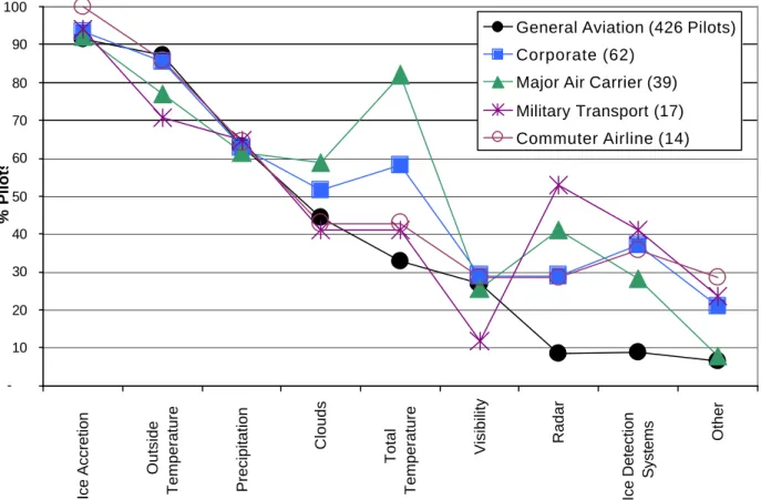
Figure 4-1 depicts the percentage of pilots who rated the listed information items as important. Ice accretion was rated important by more than 90% of pilots in all operational categories. Other information elements indicated as important by more than 50% of pilots in each operational categories include temperature (outside air or total) and precipitation.
Clouds were indicated as important by a majority of Corporate and Major Air Carrier respondents. In most cases, pilots from these groups operate jet aircraft at cruising altitudes above typical cloud deck altitude and procedurally use visible moisture and total air temperature
(TAT) below a predetermined value (typically +10°C) as information criteria for activation of the ice protection system.
A large percentage of military transport pilots indicated radar as important (53%), ice detection systems as important (41%) and a small percentage indicated visibility as important (12%). GA pilots indicated low importance of radar and ice protection systems that they are not typically equipped with. -10 20 30 40 50 60 70 80 90 100 Ice Accretion Outside Temperature Precipitation Clouds Total Temperature Visibility Radar Ice Detection Systems Other % Pilots
General Aviation (426 Pilots) Corporate (62)
Major Air Carrier (39) Military Transport (17) Commuter Airline (14)
II
) R
EPORTEDO
BSERVATIONS ANDM
EASUREMENTS:
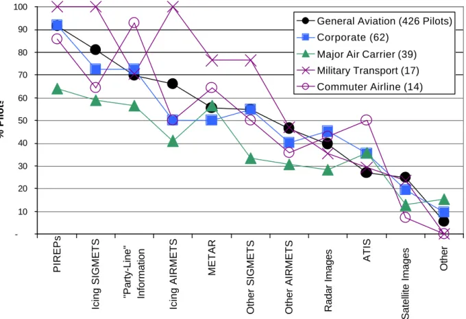
The importance ratings of the reported observations and measurements information elements are presented in Figure 4-2. A large percentage of pilots rated PIREPs as important: over 60% in all operational categories, and up to 100% for Military Transport pilots.
Military Transport pilots unanimously rated Icing SIGMETs and Icing AIRMETs as equally important, followed by METAR (77%), Other SIGMETs (77%) and PLI (71%).
For 92% of Commuter Airline pilots, PLI was rated as important, followed by PIREPs (86%) and METAR (66%) and Icing SIGMETs (65%). Commuter Airline pilots also indicated in greater percentage compared to other pilots, ATIS information as important (50%).
Compared to pilots of other operational categories, a smaller percentage of Major Air Carrier pilots indicated as important the information elements listed. Information elements listed as important include PIREPs (63%), Icing SIGMETs (59%), PLI (57%) and METAR (56%).
-10 20 30 40 50 60 70 80 90 100 PIREPs Icing SIGMETS "Party-Line" Information Icing AIRMETS METAR
Other SIGMETS Other AIRMETS Radar Images
ATIS
Satellite Images
Other
% Pilots
General Aviation (426 Pilots) Corporate (62)
Major Air Carrier (39) Military Transport (17) Commuter Airline (14)
Figure 4-2: Importance of Reported Observations and Measurements
A large percentage of Corporate pilots (92%) indicated PIREPs to be important, followed by PLI (73%), Icing SIGMETs (72%) and Other SIGMETs (55%). A larger percentage of Corporate pilots (46%) than pilots of other operational categories indicated Radar Images as important.
GA pilots indicated, in large percentage, PIREPs to be important (92%), followed by Icing SIGMETs (81%), PLI (70%), Icing AIRMETs (67%), METAR (56%) and Other SIGMETs (55%). A larger percentage of GA pilots (25%) and Military Transport pilots (24%) than pilots of other operational categories indicated Satellite Images as important.
III
) F
ORECASTS:
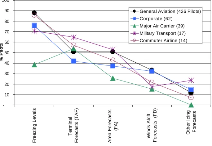
The percentages of pilots rating forecast items as important is presented in Figure 4-3. Except for Major Air Carrier pilots (39%), a majority of pilots (over 70% in all other operational categories) indicated Freezing Levels as important. Because of the nature of this information element, this may indicate the perceived importance of information along the vertical dimension.
-10 20 30 40 50 60 70 80 90 100 Freezing Levels Terminal
Forecasts (TAF) Area Forecasts
(FA)
Winds Aloft
Forecasts (FD)
Other Icing Forecasts
% Pilots
General Aviation (426 Pilots) Corporate (62)
Major Air Carrier (39) Military Transport (17) Commuter Airline (14)
Figure 4-3: Importance of Forecasts
Except for Corporate pilots, a majority of pilots indicated TAF as important forecast information elements. Overall, FDs and Other Icing Forecasts were rated less often than other elements as important by pilots in all operational categories. Other Icing Forecasts were indicated as
4.2.3 S
ECTION3 - U
SE OFC
URRENTI
CINGI
NFORMATIONP
ATHSP
RE-F
LIGHTP
HASEThe percentage of pilots who reported frequent use of specific paths for acquiring icing information is depicted in Figure 4-4 for the pre-flight phase. The information paths are ranked according to decreasing indicated information path use across all operational categories. Information frequently received by phone from the Flight Service Station (FSS), Weather Office and Dispatch, was indicated by a majority of Commuter (79%), GA (78%) and Corporate (61%) pilots. Information frequently received in person from the same services was indicated by a majority of Military Transport pilots (65%). The most frequently used icing information path for Major Air Carrier Pilots was indicated to be the Dispatch Paperwork (64%).
0 10 20 30 40 50 60 70 80 90 100 FSS, Weather Office, Dispatch by phone
DUATS Web Direct
Observations Commercial Weather Provider FSS, Weather Office, Dispatch in person Dispatch Paperwork AM Radio % Pilots
General Aviation (426 Pilots) Corporate (62)
Major Air Carrier (39) Military Transport (17) Commuter Airline (14)
Figure 4-4: Reported “Frequent” Use of Pre-Flight Icing Information Path
A majority of GA pilots also indicated frequent use of the Direct User Access Terminal (DUAT - 62%) and the Web (50%). Those information paths was indicated less frequently by Corporate pilots (49% and 35% for DUATS and Web, respectively) and much less frequently used by pilots of other operational categories (less than 25%).
Other information elements which were considered important by the different groups were the following: A large percentage of Corporate pilots also indicated frequent use of Direct Observations (48%) and frequent use of Commercial Weather Provider information elements (40%). Major Air Carrier pilots indicated the frequent use Direct Observations (40%), followed by FSS, Weather Office and Dispatch by phone (38%). A majority of Military Transport pilots indicated the frequent use of Direct Observations (58%), followed by FSS, Weather Office and Dispatch by phone (47%). Commuter Airline pilots indicated the frequent use of Dispatch Paperwork (43%). AM Radio was not indicated to be frequently used (less than 5% across all operational categories).
I
N-F
LIGHTThe percentage of pilots who reported frequent use of in-flight icing information paths in-flight is depicted in Figure 4-5. Information paths are ranked by use across all operational categories.
Information accessed via Direct Observations was indicated to be frequently used by over 75% of pilots in all operational categories. “Party-Line” Information (PLI) was also indicated to be frequently used by a majority of Commuter Airline (72%), GA (57%) and Corporate (55%) pilots.
Other frequently used information paths indicated by GA pilots included Air Traffic Control (ATC – 48%), En-route Flight Advisory Service (EFAS - 47%), and FSS or Dispatch on radio (45%). It was found that pilots of other operational categories indicated a smaller percentage (between 7 and 20%) use of EFAS, in comparison to GA pilots. It was also found that GA pilots indicated in much smaller percentage (8%) frequent use of Airborne Sensors, in comparison to pilots of other operational categories (over 30%). A majority of Military Transport pilots indicated more frequent use of FSS or Dispatch on radio (53%) than pilots of other operational categories.
0 10 20 30 40 50 60 70 80 90 100 Direct Observations Party-Line Information ATC FSS or Dispatch
on radio Flight Watch (EFAS on 122
MHz) Airborne sensors
Other
ACARS
% Pilots
General Aviation (426 Pilots) Corporate (62)
Major Air Carrier (39) Military Transport (17) Commuter Airline (14)
4.2.4 S
ECTION4 - A
DDITIONALI
NFORMATIOND
ESIRED:
Figure 4-6 presents results on pilot reports of additional information that would help support icing-related decisions. It was found that more PIREPs would be desired by most pilots (except for Major Air Carrier pilots); better forecasts and graphical information would also be highly desirable. 0 2 4 6 8 10 12 14 More PIREPs Better forecasts Graphical
Cloud tops and temperature
More ATC
sollicited PIREPs
Accurate
location info
Isotemp charts - freezing level
More "navigable" / radar Near real-time Remotely detected icing areas % Pilots
General Aviation (426 Pilots) Corporate (62)
Major Air Carrier (39) Military Transport (17) Commuter Airline (14)
What additional information and/or forecasts, if any, do you think would be useful to help making
decisions when flying in icing conditions? Please feel free to
add as much information as you wish.
Note: 210 Pilots (36 % Total) Gave Free Response to this Question
Figure 4-6: Additional Information Desired
Additional information desired by pilots included the following elements: Iso-temperature Charts with Freezing Level information was indicated by Military Transport, Major Air Carrier and GA pilots; elements such as Accurate Information on Icing-Zone Location, radar-like information, Near-Real time information, were indicated by Corporate, Major Air Carrier and GA pilots; Cloud Tops and Temperature were indicated by GA and Major Air Carrier pilots; More ATC solicited PIREPs and Remotely Detected Icing Areas were indicated by GA and Corporate pilots.
4.2.5 S
ECTION5 - I
NFORMATION ONS
IGNIFICANTA
IRCRAFTI
CINGE
NCOUNTERS:
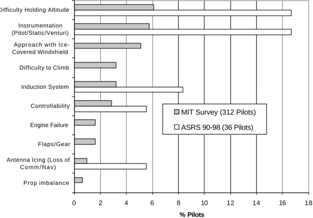
Figure 4-7 depicts the ten recurring areas of ice impact according to survey results and NASA ASRS reports. The most frequently mentioned icing impacts, recurring in 6% of the cases in the survey results and in 17% of the cases in the ASRS results referred to Difficulty Holding Altitude. The second most frequently reported icing problems were related to Instrumentation (such as pitot, static or venturi) problems. Other recurrent aircraft performance problems included Difficulty to Climb (5% of survey results), Controllability problems (3% and 5% in survey and ASRS results, respectively), Flaps and/or Gear deployment problems (2% of survey results), Engine Failure (2% of survey results) and Propeller Imbalance (1% of survey results).
Other recurrent ice accretion effects not directly impacting aircraft performance but seriously affecting flight operations include: Reduced visibility in approach with ice-covered windshield (5% of survey results), Induction system problems (3% of survey results and 8% of ASRS results), and Antenna icing problems causing Failure of navigation and / or communication systems (1% of survey results and 5% of ASRS results).
0 2 4 6 8 10 12 14 16 18
Prop imbalance Antenna Icing (Loss of
C o m m / N a v ) Flaps/Gear Engine Failure Controllability Induction System Difficulty to Climb Approach with Ice-Covered Windshield
Instrumentation (Pitot/Static/Venturi) Difficulty Holding Altitude
% Pilots
MIT Survey (312 Pilots) ASRS 90-98 (36 Pilots)
Figure 4-8 depicts the nine recurring themes of reported pilot escape actions according to the survey results. The most frequently mentioned escape actions included Descending to Warm conditions--conditions where warmer air temperature does not support ice accretion--or VMC (18% of survey results and 16% of ASRS results) and Diverting to Land (13% of survey results and 36% of ASRS results). It was found that escape actions involving vertical maneuvers (i.e., including either a climb or a descent) accounted for 44% of all ASRS narratives and 12% of all survey responses. It was also found that 3% of pilots in the survey results and 14% of pilots in the ASRS results declared either and emergency or requested priority with ATC.
0 5 10 15 20 25 30 35 40
Declared Emergency or Priority Turn/Descend to VMC Turn to VMC Descend to dry (snow) Climb to Warm (ZR)
Turn and Descend Complete IMC Approach Climb to VMC Divert to land Descend to Warm or VMC
% Pilots
MIT Survey (312 Pilots) ASRS 90-98 (36 Pilots)
4.2.6 S
ECTION6 - K
EYI
CING-R
ELATEDD
ECISIONS:
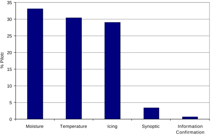
Data on key icing-related decisions is presented in Figure 4-9 for all operational categories. It should be noted that the data is dominated by responses from GA pilots (73%) and pilots flying aircraft not equipped for flight in known icing (72%). Recurring icing-related decisions were the Go/No-Go decision (42%), the Escape decision (23%), the Avoidance versus Penetration decision (8%) and decisions regarding the Management of the Ice Protection Systems (6%). Pilots also mentioned key icing-related decision such as Proceed/Not-Proceed (3%), the action of Monitoring the situation (3%) and strategic Route Optimization decisions (2%). In a few cases, pilots also mentioned the identification of whether or not they were in a situation worth Declaring as an Emergency (1%). The dominant criteria used by pilots for making strategic go/no-go decisions was indicated to be the escape route accessibility. In turn, it was found that the evaluation of an optimal escape route involved deciding between actions such as climbing, descending, reversing course or landing at an alternate destination. Avoidance criteria were mentioned to include avoiding visible moisture at temperatures below freezing.
0 5 10 15 20 25 30 35 40 45 Go/No-Go Escape Avoidance Management Proceed/Not
Proceed Monitoring Route
Optimization
Declare
Emergency?
% Pilots