HAL Id: tel-00612332
https://tel.archives-ouvertes.fr/tel-00612332
Submitted on 28 Jul 2011HAL is a multi-disciplinary open access
archive for the deposit and dissemination of sci-entific research documents, whether they are pub-lished or not. The documents may come from teaching and research institutions in France or abroad, or from public or private research centers.
L’archive ouverte pluridisciplinaire HAL, est destinée au dépôt et à la diffusion de documents scientifiques de niveau recherche, publiés ou non, émanant des établissements d’enseignement et de recherche français ou étrangers, des laboratoires publics ou privés.
cooperative communications for wireless sensor networks
Teck Aguilar
To cite this version:
Teck Aguilar. Toward a beaconless geographic routing with cooperative communications for wireless sensor networks. Other [cs.OH]. Institut National des Télécommunications, 2010. English. �NNT : 2010TELE0032�. �tel-00612332�
Thèse n° 2010TELE0032
Ecole Doctorale EDITE
Thèse présentée pour l’obtention du diplôme de
Docteur de Télécom & Management SudParis
Doctorat conjoint TMSP-UPMC
Spécialité :
Informatique, Télécommunications et Electronique
Par Teck Aguilar
Titre
Vers un protocole de routage géographique avec contention et communications coopératives pour les réseaux de capteurs
Soutenu le 15 décembre 2010 devant le jury compose de:
André-Luc Beylot Rapporteur INPT/ENSEEIHT
Luis Muñoz Rapporteur Université de Cantabria
Guy Pujolle Examinateur Université Pierre et Marie Curie
Pascale Minet Examinateur INRIA Rocquencourt
Dominique Barth Examinateur Université de Versailles
Hassnaa Moustafa Examinateur Orange Labs, France
Vincent Gauthier Encadrant Telecom Sud Paris
Hossam Afifi Directeur de
thèse
Thèse n° 2010TELE0032
Ecole Doctorale EDITE
Submitted in partial satisfaction of the requirements for the degree of
Doctor of sciences in Télécom & Management SudParis
Doctor of Sciences TMSP-UPMC
Specialization: Computer sciences
Presented by Teck Aguilar
Title
Toward a Beaconless Geographic Routing with Cooperative Communications for Wireless Sensor Networks
December 15 2010; committee in charge:
André-Luc Beylot Rapporteur INPT/ENSEEIHT
Luis Muñoz Rapporteur Universidad de Cantabria
Guy Pujolle Examinateur Université Pierre et Marie Curie
Pascale Minet Examinateur INRIA Rocquencourt
Dominique Barth Examinateur Université de Versailles
Hassnaa Moustafa Examinateur Orange Labs, France
Vincent Gauthier Encadrant Telecom Sud Paris
Hossam Afifi Directeur de
thèse
Acknowledgement
I would like to acknowledge my advisor Prof. Hossam Afifi who gave me the opportunity to join the Wireless Networks and Multimedia Services Department (RS2M) at Telecom SudParis. I also thank Dr. Vincent Gauthier who so kindly co-advised this work, spent so many hours helping me and had influenced my research. I am deeply grateful for his support.
I thank Syue-Ju, all the friends from Telecom SudParis: S´epideh, Ines, Anahita, Bastien, Makhlouf, Mehdi, Vincent V, Abid, Boutabia, Emad, Ahmad, Cuiting, Mariem, and so many other that i knew during my research period.
I thank my brothers and sisters and in particular my parents Ronay and Sandra - You did a great job! To my family-in-law for their support and made me feel at home in a foreign place.
I would like to thank my son Ga¨el and finally to my lovely wife Marianne who supported and motivated me to continue even in the difficult and frustrating times. I love you.
To Marianne, Ga¨el, Mateo
and
My parents
Abstract
In Wireless Sensor Networks, the routing task is an essential service that forwards the sensor readings to some data collection points in the network on the basis of the multi-hop relaying. The routing task is particularly challenging as it should be realized in an energy efficiency manner with limited amount of information. Geographic routing is a promising approach because of its good scalability and local information use, but when deploying such approach, some problems still remain because of some practical difficulties.
In this thesis, some techniques have been explored to address two issues in geographic routing protocols: i) Cost associated to: the wireless channel impair-ments due to fading, mobility patterns or high dynamic environment and ii) the management of constrained resources of the nodes. To tackle these issues, two protocols were presented: a beaconless Cooperative Geographic cross-layer
proto-col for ad hoc and sensor networks (CoopGeo) and a Relay-Aware Cooperative Routing protocol (RACR).
Unlike traditional geographic routing protocols, CoopGeo deals the wireless impairments by means of a cross-layer framework where a beaconless geographic routing approach was used to build the route not only in a local manner, but also on the fly worked with a relay selection mechanism to exploit the broadcast nature of the wireless communications.
The RACR protocol exploits the coverage extension as a result from node cooperation to improve the non-cooperative geographic routing. It is an alterna-tive to scenarios where network resources like energy should be preserved while respecting a Symbol Error Rate constraint (SER). Thus, the proposed routing protocol, enables a node to make a local route decision depending on the geo-graphic location of a relay while this relay is selected with the purpose of providing the maximum coverage extension toward the destination.
The results obtained from extensive evaluations of CoopGeo and RACR con-tributions, have demonstrated that both solutions are applicable to sensor net-works with very variable channel environments or unpredictable changes in the
network topology. Therefore, we have proved that our cross-layer vision of the problem provided an integrated solution to problems like inefficient routing paths, congested medium access, inaccurate location information, and lossy links.
R ´esum ´e
Le routage dans les r´eseaux de capteurs, est un service essentiel qui transmet les lectures des capteurs `a certains points de collecte de donn´ees dans le r´eseau sur la base des relais multi-saut. Cette tˆache est particuli`erement difficile car elle doit ˆetre r´ealis´e d’une mani`ere efficace au niveau de consommation de resources et avec une quantit´e limit´ee d’informations disponible. La facilit´e de mise `a l’´echelle et l’utilisation d’information local pour fonctionner ont permis au routage g´eographique ˆetre consid´er´e comme une approche prometteuse. Cependant, lors de son implementation, certains probl`emes subsistent en raison des difficult´es pratiques.
Dans ce travail de recherche, two probl´ematiques inh´erentes aux protocoles de routages g´eographique ont ´et´e ´etudi´es: i) Le coˆut associ´e: aux ´evanouissements li´es aux obstacles et aux multi-trajets suivis par un signal transmis sur un canal radio, aux changements rapides des conditions physiques du canal de transmis-sion and ii) l’administration de resources affect´es `a chaque noeud appartenant au r´eseau. Afin de r´esoudre ce probl`eme, deux protocoles ont ´et´e pr´esent´es: un protocole de routage g´eographique avec communications coop´eratives,
beacon-less Cooperative Geographic cross-layer protocol for ad hoc and sensor networks (CoopGeo) et un protocole de routage bas´e sur le principe d’extension de
couver-ture: Relay-Aware Cooperative Routing (RACR).
Contrairement aux protocoles de routage g´eographique traditionnelles, Coop-Geo est un protocole de routage ”beaconless” bas´e sur une architecture inter-couches o`u le routage non seulement est r´ealis´e localement, mais aussi `a la vol´e. En plus, les probl`emes li´es `a la couche physique sont trait´es par les communica-tions coop´eratives qui exploitaient la nature de la diffusion sans fil.
Le protocole RACR exploite la propri´et´e offert par les communications coop´eratives: l’extension de la couverture radio. Cet propri´et´e permets d’am´eliorer les perfor-mances d’un r´eseau que `a l’origine utilis´e un protocole de routage g´eographique traditionnel. RACR est une alternative aux scenarios o`u l’objectif principal est celui de diminuer au maximum la consommation des resources du r´eseau et au
mˆeme temps assurer que le r´eseau offre un taux d’erreur par symbole garanti (SER). Ainsi, le protocole RACR, permets `a un noeud effectuer des decisions dites locales, par rapport au routage des paquets qui dependent de la localisation g´eographique d’un noeud relai, tandis que, ce noued relai a la finalit´e de donner une extension maximale au niveau de couverture radio envers la destination.
Les r´esultats obtenus `a partir des ´evaluations approfondies de CoopGeo et RACR, ont d´emontr´e que les deux solutions sont applicables aux r´eseaux de cap-teurs en pr´esence forte mobilit´e, environnements tr`es variables au niveau radio, ou avec des erreurs aux niveau de l’information de localisation. Par cons´equent, nous avons prouv´e que notre vision de inter-couche du probl`eme a fourni deux solutions efficaces, en termes de chemins, acc`es au media, probl`emes li´es `a l’information impr´ecise de localisation, et des liens perturb´es.
Contents
1 Introduction 17
1.1 Context and challenges . . . 18
1.2 Contributions . . . 20
1.3 Thesis Outline . . . 21
2 State of the art 23 2.1 Routing Protocols for Wireless Sensor Networks . . . 23
2.1.1 Topology-based routing . . . 24
2.1.2 Position-based routing (Geographic Routing) . . . 25
2.2 Geographic Routing Protocols . . . 25
2.2.1 Forwarding Strategies ”Greedy Forwarding” . . . 27
2.2.2 Some Traditional Geographic routing protocols . . . 29
2.2.2.1 Greedy Face Greedy (GFG) . . . 29
2.2.2.2 Greedy Perimeter Stateless Routing (GPSR) . . . 29
2.2.2.3 Other Geographic protocols derived from greedy + face union . . . 30
2.2.2.4 Greedy Distributed Spanning Tree Routing (GDSTR) 30 2.2.2.5 Local Tree based Greedy Routing (LTGR) . . . . 31
2.2.3 Beaconless geographic routing (BLGR) . . . 31
2.2.3.1 Beaconless Routing (BLR) . . . 33
2.2.3.2 Contention-Based Forwarding (CBF) . . . 34
2.2.3.3 Implicit Geographic Forwarding (IGF) . . . 35
2.2.3.4 Geographic Random Forwarding (GeRaF) . . . . 36
2.2.4 New Beaconless Geographic Routing Protocols . . . 37
2.2.4.1 Beaconless On Demand Strategy for Geographic Routing in Wireless Sensor Networks (BOSS) . . 37
2.2.4.2 Select and Protest-based Beaconless Georouting with guaranteed delivery . . . 38
2.3 Virtual Coordinates . . . 39 13
2.3.1 Location-aware landmarks . . . 39
2.3.2 Location-unaware landmarks . . . 40
2.3.3 Landmark-free Virtual Coordinates . . . 42
2.4 Cooperative Communications . . . 42
2.4.1 General concept . . . 43
2.4.2 Relay behavior and protocols . . . 43
2.4.3 Cooperative communications classification . . . 44
2.4.4 Relay selection . . . 46
2.4.5 Single relay selection . . . 47
2.5 Discussion . . . 49
3 Models and tools 51 3.1 Introduction . . . 51
3.2 Network models . . . 52
3.2.1 Discussion . . . 56
3.3 Power-attenuation model . . . 56
3.4 Radio propagation models . . . 57
3.4.1 Discussion . . . 59
3.5 Mobility models . . . 59
3.6 Simulation tools . . . 60
4 CoopGeo: A Cooperative Geographic Routing Protocol 63 4.1 Introduction . . . 64
4.2 Network Model and Problem Statement . . . 67
4.2.1 Network Model . . . 67
4.2.2 Problem Statement . . . 70
4.3 CoopGeo: A geographic cross-layer protocol for cooperative wire-less networks . . . 72
4.3.1 Beaconless Greedy Forwarding (BLGF) . . . 72
4.3.1.1 Geographic contention-based forwarder selection (TCBF) . . . 73
4.3.2 Beaconless Recovery Forwarding (BLRF) . . . 74
4.3.3 MAC-PHY Cross-Layered Relay Selection . . . 76
4.3.3.1 Relay selection criterion based on geographical in-formation . . . 76
4.3.3.2 Geographic contention-based relay selection . . . 77
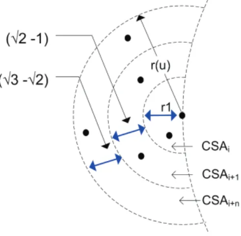
4.3.3.3 Relay selection area . . . 78
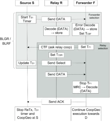
4.3.4 CoopGeo in Action . . . 79
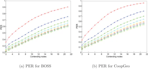
4.4 Performance Evaluation . . . 81
4.4.1 Packet Error Rate (PER) . . . 83
Contents 15
4.4.3 Varying the contention window Tmax . . . 84
4.4.3.1 CTF-Relayed message Collision Probability . . . 85
4.4.3.2 Varying the constellation size . . . 85
4.5 Discussion and conclusions . . . 86
5 RACR: Relay-Aware Cooperative Routing 91 5.1 Introduction . . . 91 5.2 System Model . . . 93 5.2.1 Signal Model . . . 93 5.2.1.1 Cooperative Transmission . . . 93 5.2.1.2 Direct Transmission . . . 94 5.2.2 Channel Model . . . 94
5.2.3 Theoretical Average SER Performances . . . 95
5.2.3.1 Average SER under Direct Transmission . . . 95
5.2.3.2 Average SER under DF Cooperative Transmission 95 5.2.4 Network Model . . . 96
5.3 SER-Based Radio Coverage Formulation . . . 97
5.4 RACR: Relay-Aware Cooperative Routing . . . 100
5.4.1 Contention Timer Setting for Relay Selection . . . 101
5.4.2 Contention Timer Setting for Forwarder Selection . . . 102
5.5 Performance Evaluation . . . 103
5.5.1 Should we choose the relay as far as possible from the source?103 5.5.2 Coverage Extension . . . 104
5.5.3 Routing performance . . . 106
5.6 Conclusions . . . 108
6 Conclusion and Future Directions 109 6.0.1 Future directions . . . 111
A Resum´e du manuscrit de th`ese en fran¸cais 115 A.1 Vers un protocole de routage g´eographique avec contention et com-munications coop´eratives pour les r´eseaux de capteurs . . . 115
B La Probl´ematique 117 B.1 Contexte et d´efis . . . 118
B.2 Contributions . . . 119
C Contributions 121 C.1 CoopGeo : A Cooperative Geographic Routing Protocol . . . 121
C.1.1 Mod`ele de communication . . . 121
C.1.2 CoopGeo : A geographic cross-layer protocol for coopera-tive wireless networks . . . 124
C.1.3 Transmission greedy sans balises de contrˆole (BLGF) . . . 125
C.1.3.1 Selection `a base de temporisateurs (TCBF) . . . . 125
C.1.3.2 Recuperation greedy sans balises de contrˆole (BLRF)126 C.1.4 Selection du relais bas´e sur des informations g´eographiques 126 C.2 Evaluation des Performances . . . 128
C.2.1 Taux d’erreur de paquets (PER) . . . 128
C.2.2 Probabilit´e d’erreur dans la transmission de bout en bout . 129 C.2.3 Variation des param`etres d’entr´ee . . . 129
C.3 RACR : Relay-Aware Cooperative Routing . . . 131
C.4 SER-Based Radio Coverage Formulation . . . 131
C.5 Architecture de RACR . . . 134
C.5.1 Selection du relais . . . 136
C.5.2 Selection du noeud interm´ediaire . . . 136
C.6 Evaluation des performances . . . 137
C.6.1 Extension de la couverture . . . 137 C.6.2 Efficacit´e ´energ´etique . . . 138 Bibliography 139 Glossary 151 List of Figures 153 List of Tables 157
Chapter
1
Introduction
Wireless technologies has grown rapidly in the last decades and the advances in hardware components have followed the same trend enabling the massive pro-duction of communication devices like laptops, cellular phones, personal digital assistants (PDA), sensors, processors, etc. Since these devices are getting smaller and cheaper, their association with some technologies leads to the development of new kinds of wireless networks or the enhancement of existing ones such as cellu-lar networks (2G, 2.5G, 3G). Other type of wireless networks are the traditional wireless networks that are spanned into infrastructure and infrastructure-less like ad-hoc, sensor and mesh networks. These new network types, support a certain number of applications, including WLAN hotspots, real-time communications, home networking, surveillance systems, industrial control, vehicular networks, sensor networks and many other. Data wireless network (making reference to IEEE 802.11 and derivations) have been the center of research and commercial interest for several years, nowadays, we can find Wi-Fi services almost every-where.
In spite of the industry and users interest oriented to traditional wireless networks, recently the scientific and industrial community is turning into a dif-ferent scenario where a spontaneous group of electronic devices try to communi-cate without any infrastructure: the ad-hoc and sensor networks. They present important challenges in their architecture design that are inherited from their basic characteristics. Ad-hoc and sensor networks are wireless, self-organizing systems formed by nodes in communication range of each other forming a tem-poral network. In general, ad hoc networks are formed dynamically by static or mobile nodes that are connected via wireless links excluding a centralized admin-istration or a network infrastructure, the nodes can join and quit the network spontaneously, thus a method to organize themselves is needed to support all
the topology changes providing without interruption the routing paths from the source towards the destination, briefly, the routing philosophy is to cooperate between nodes to forward the data in a multihop manner.
Wireless sensor networks (WSN) belong to the class of ad hoc networks, but they have some extra characteristics that make them a special case, even if sen-sor networks closely looks like the behavior of ad hoc networks, sharing many challenges as limited energy available to each node and the error-prone channels, they have differences to keep in mind: for example, the small size of nodes in a WSN involve that the nodes have very limited resources such as, processing speed, memory, energy, and transmission power; as the nodes can be small, they can be deployed in very large quantities, presenting higher node densities. We can also add that they are inexpensive, the nodes are unattended after deployment and designed for a prolonged lifetime with no maintenance or troubleshooting, and shorter transmission ranges.
Thus, WSN are rather designed to detect events or natural phenomena, nodes collect the data, process them and transmit to some users. By the nature of those characteristics, the most challenging issues in sensor networks are the efficient use of limited resources and the adaptable to topology changes derived from the condition of the communication channel.
1.1
Context and challenges
The present work is substantially oriented to the wireless sensor networks, even if some protocols, algorithms and techniques are also applied to other types of wireless networks. Thus, in order to clearly define the scope of the work we present the basic characteristics and challenges attached to our subject under study.
The wireless Sensor Networks, are composed of a large number of sensor which are small in size and are able to sense, process and communicate with each other where the main finality is to detect events or phenomena, collect and process data and transmit the information to the users. In addition to the characteristics related to the wireless communication, the sensor networks include some other basic characteristics inherited from the way they work:
• Self-organizing capabilities
• Short range communication and multihop routing • Dense deployment and cooperative effort of nodes
• Frequent changing topology due to fading, mobility and node failures • Limitations in energy, transmit power, memory, and computing power • Data centric communication model
1.1. Context and challenges 19 In the WSN applications classes, we mention some of them to accentuate the difference with other kind of wireless networks, such as:
• Infrastructure security
• Environment and habitat monitoring • Industrial and agriculture sensing • Traffic control
• Disaster prevention • Medical care
From the above summary, it can be remarked that the data centric com-munication model influences the design of routing protocol, where all the data generated by the nodes is forwarded to some data collection points commonly known as sinks. With this communication model in mind, it can be said that the design of wireless sensor networks has some important tasks to fulfill such as, con-trol the consumption of limited resources that are affected by the transmissions and reception of data packets, and to limit the wireless channel effects generated by two physical phenomena: 1) From multipath propagation of the electromag-netic waves that generates variations in the received signal strength as function of the node location and frequency. 2) From the influence of the eventual motion of nodes that produce the effect called wireless channel variation, generally called fading. Thus, a rigorous protocol design is imposed with the goal of minimize the resources consumption (ie. energy) and maximize the network lifetime with the constraint of detecting the topology changes so as to maintain the network connectivity and calculate the proper routes from the sensor nodes to the sinks.
In order to effectively tackle these WSNs challenges, the research community has produced a lot of works, focusing on traditional layered approaches, where each layer of the protocol stack (ie. network, Medium Access Control and physi-cal) is unaware of the operation of the other layer, eliminating thus, the benefits of joint optimization across protocol layers which can improve the network per-formance.
Therefore, the use of a cross-layer design must be mandatory, where the avail-ability of some important information among the stack layers would allow a node to make more effective routing decisions as it will have a wider view of the network behavior, resulting in an improvement in the global network performance.
This dissertation, take the cross-layer approach as reference to enhance the layered approach and propose an architecture designed to analyze the interaction between the network layer to route de packet to the destination, the medium access control (MAC) layer to get access to the wireless channel and the physical layer to adapt the protocol to the wireless conditions of the environment. We show in our contributions, that a cross-layer architecture will optimize the
inter-actions between these three layers and achieve a high performance and reliable communication in the network.
1.2
Contributions
During this research work, Geographic Routing is considered as a concrete solution to the routing issue where the sensor nodes builds on a local manner the route to the sink node. In this scope, the main goal of this thesis is to fill the gap between the traditional geographic routing protocols and the physical environment where the sensor nodes are located. To reach this goal, the routing problem with lossy links is treated by the use of a Beaconless Geographic Routing approach to build the route not only in a local manner, but also on the fly and cooperative communications approach since it is an attractive scheme that uses the spatial diversity of nodes to exploit the broadcast nature of the wireless chan-nel, allowing to the radios located at each node to jointly transmit information through relaying. Thus, the primary contributions are:
• A cross-layer design framework called CoopGeo (Cooperative Communica-tions for Geographic routing) is proposed. CoopGeo has been extensively evaluated and compared to the traditional beaconless routing protocol via simulations. CoopGeo performs the greedy forwarding mechanism without using beacon messages. Instead, each node broadcasts the message and each receiving node competes to forward it based on its local metric. Once the forward node wins the contention to transmit the message, we eventually apply a cooperative communication with single relay selection mechanism where the source node and relay node will jointly transmit the informa-tion in the wireless channel. With CoopGeo, we improve the physical layer performance in terms of reliability, extending also the network lifetime com-pared to other geographic routing protocols which do not consider the MAC layer issues. We also apply a mechanism to get out from a local minimum problem using a beaconless planarization mechanism.
• The RACR protocol exploits the coverage extension as a result from node cooperation to improve the non-cooperative geographic routing. It is an alternative to scenarios where network resources like energy should be pre-served while respecting a Symbol Error Rate constraint (SER). Thus, the proposed routing protocol, enables a node to make a local route decision depending on the geographic location of a relay while this relay is selected with the purpose of providing the maximum coverage extension toward the
1.3. Thesis Outline 21 destination.
The results obtained from the evaluation of CoopGeo and RACR makes us think that both solutions are applicable to sensor networks in presence of high mobility or highly variable channel environments. Thus, we can say that our cross-layer vision of the problem may provide an integrated solution to problems like define efficient routing paths, medium access, localization, or fault tolerance. In addition to the main contributions, this research work provides the follow-ing complementary contributions:
• An extensive state of the art where some important links between the geo-graphic routing protocols (with its derivation: beaconless geogeo-graphic rout-ing and virtual coordinates) and the cooperative communications were es-tablished.
• Two different beaconless geographic contributions were integrated into one framework. The traditional beaconless greedy forwarding from one contri-bution and the beaconless recovery forwarding from other contricontri-bution were taken and then a new framework was built. Over this new framework, the first contribution was built on.
1.3
Thesis Outline
This thesis is organized as follows.
• Chapter 2, first, reviews the state of the art on routing in wireless sensor networks, giving special interest to geographic routing and beaconless geo-graphic routing. Then, it presents the cooperative communications funda-mentals, addressing their advantages, their challenges, and their drawbacks. It lastly, gives an overview of the related works covering relay selection on cooperative communications for sensor networks.
• Chapters 3 covers the theory of the models discussed and used in the present work, such graph models, radio propagation models, mobility mod-els, etcetera. This information will help us to allow the appropriate under-standing of the contributions. It also presents the tools used to analyze the performances of the routing protocols.
• Chapter 4 presents the details about the first contribution: CoopGeo. With a cooperative strategy, it builds a reliable Beaconless Geographic Routing
protocol for Wireless Sensor Networks using a contention-based relay selec-tion mechanism. it also introduces the model and the policies to select the relay nodes according to a predefined metric.
• In Chapter 5, the second contribution, RACR, is described. It is a routing protocol that takes advantage of coverage extension offered by cooperative communications to achieve a scalable and efficient sensor network perfor-mance.
• Chapter 6 summarizes our contributions, concludes the thesis and discusses the perspectives and further improvement to the contributions.
Chapter
2
State of the art
In the first part of this chapter, it is provided an introduction to routing in sensor networks and it also supplies an overview to the prior relevant works to the subject developed in other parts of the thesis. It starts by describing generally the existing approaches to the routing problem. Then it covers the Geographic Routing (GR), presenting the way how it works, the advantages, the challenges and the limitations. Finally it presents a Beaconless Geographic Routing (BLGR) as a derivation of the traditional GR, giving some specific references to other related works.
In the second part, the cooperative communications as a mechanism to help the wireless communications are introduced. It covers a brief overview and in-troduction to this communication scheme and presents why it represents a lot of interest in the design of a communication protocol. Then it covers the back-ground of several basic areas: communications theory, graph models, and radio propagation models in order to provide the basic ideas used in this thesis and allow thus its appropriately understanding.
2.1
Routing Protocols for Wireless Sensor
Net-works
The basic tasks of sensors comprised in a WSN are sensing or gathering the information from the analyzed phenomenon, processing, and transmitting the sensed data to a destination point commonly called sink. To deliver the data to the sink, sensor nodes use the multihop principle whenever infrastructure is unavailable or when the direct transmission from the source to the destination is impossible, thus the node sensing the data uses intermediate nodes to relay its
packets across the network until it reaches the destination. Therefore, the source and the intermediate nodes have to decide which neighbor the packet will be sent to, using a routing protocol as a tool to make this decision.
It can be said that routing is still a challenging issue in mobile ad hoc networks and particularly in sensor networks [Akyildiz 02], due to their limited resources, the nodes mobility and the physical environmental conditions. In these kinds of networks, the most traditional routing protocols are classified into two categories: the topology-based and position-based routing protocols.
2.1.1
Topology-based routing
Topology-based routing protocols use the information about the neighbors or links existing in the network to perform packet forwarding. They can be further divided into proactive, reactive, and hybrid approaches. Proactive algo-rithms employ classical routing strategies derived from wired routing protocols such as distance vector or link state protocols. To illustrate the former strategy, we can cite from [Perkins 94] the Destination Sequenced Distance Vector proto-col(DSDV) and for the latter strategy, from [RFC 03] the Optimized Link-State Routing protocol(OLSR) or from [Ogier 04] the Topology-Based Reverse Path Forwarding (TBRPF). The protocols belonging to this approach try to keep a consistent and up to date routing information about the paths available in the network by exchanging control messages at fixed time periods. The main draw-back of this approach is that the maintenance of routing tables may occupy a significant part of the available bandwidth and nodes resources, and this is even worse when the topology of the network changes frequently.
In contrast to this problem, reactive protocols establish a route to a given destination only when a node requests it by initiating a route discovery process and once the route is established, the data communication starts, thereby they reduce the resource consumption of the network. This tend to be efficient in small networks, however, this scheme does not scale well in large networks due to the significant overhead generated to find the paths between the source and destination nodes and the delay to transmit the data packets. Even if route maintenance is restricted to the routes in use, the process can generate overhead in the network when the network topology changes very frequently or the packet can be lost in the transmission process if the new route is not known. Examples of this kind of protocols are Dynamic Source Routing (DSR) [Johnson 04] and Ad-hoc On-Demand Distance Vector (AODV) [Perkins 03].
Finally, hybrid approach applies principles of both routing schemes, proactive for the local neighborhood and reactive for the distant nodes or they may modify their behavior given some circumstances, sometimes using proactive rules and other times using the reactive rules. These kind of protocols try to mix combine
2.2. Geographic Routing Protocols 25 the power of both schemes, some well-known examples are Zone Routing Protocol (ZPR) [Haas 97], Location-Aided Routing (LAR) [Ko 00] and Distance Routing Effect Algorithm for Mobility (DREAM) [Basagni 98].
2.1.2
Position-based routing (Geographic Routing)
A different vision from topology-based protocols, is the one presented by the position-based protocols that from now and on, we will call geographic-based routing protocols. They use the node location to route the information, taking advantage of the presence of low power GPS receivers at sensor nodes or the use of other techniques to build a coordinate system with virtual or absolute coordinates. Geographic routing in essence works at the network layer providing the way how a packet will be delivered to the destination or sink node based only on local information, for instance the node location. Hence, geographic routing [Stojmenovic 02] is an attractive approach to route in ad hoc networks and wireless sensor networks, because it is efficient, scalable, and it does not need to know the topology of the network.
Unlike topology-based protocols, geographic-based protocols require very few control traffic to work and they do not need to create or maintain the whole route from source to destination and thus they eliminate the overhead of frequent topology updates.
Many Geographic-based routing protocols have been proposed in the litera-ture. In the following, the geographic basic principles are described. Then, their benefits and forwarding strategies are stated. Next, some geographic routing protocols are presented, and finally, it discusses their drawbacks.
2.2
Geographic Routing Protocols
In this section, we present some principles used in the development of geo-graphic routing protocols for wireless sensor networks. Some of them, have been refined and improved, but usually, some basic ideas remain the same such as:
• Each node knows its geographic location using some localization mechanism or hardware composant. Location awareness is essential to this routing approach, so it is expected that wireless nodes will be equipped with a GPS or will execute some localization techniques. Several techniques exist for location sensing based on proximity or triangulation using radio signals, acoustic signals, or infrared.
• Each node knows its direct neighbors locations (1-hop neighbors). This in-formation could be obtained by a periodic inin-formation exchange containing the position in form of beacons, hellos or broadcast messages. It is
impor-tant to note that this assumption could be relaxed and give birth to another category of geographic routing.
• Each node trying to send data packets already knows the destination loca-tion.
Moreover, several benefits associated to geographic routing protocols are stated: • Low overhead, since the establishment and maintenance of routes are not
required in protocols that use location information to route data.
• Localized algorithm, since a node only interacts with other nodes in a re-stricted vicinity to determine which neighbor will forward the message. • Scalability, since these protocols are localized, they neither need to know
global information nor recompute the routing tables to follow the topology changes.
• High performance since they can adapt rapidly to the network dynamic, respecting resource constraints of the nodes.
In geographic routing, the source and intermediate nodes forward the packets with respect to a predefined routing metric, in general: the geographic progress to the destination. This kind of protocols have a ”greedy” behavior, selecting the neighbor that minimizes the distance to the destination. However this greedy mechanism could fail when it gets into a local minimum: a packet may be stuck at a node that does not have a neighbor closer to the the destination than itself to forward the packet.
Figure 2.1: Greedy Forwarding: Node s forwards the packet to neighbor F1
Traditional geographic routing protocols also need to send beacons messages periodically to get their direct neighbors position and execute the greedy mech-anism, however, they may present problems with the mobility of nodes and even if they can adapt the beacon frequency to the degree of the network mobility in order to keep the nodes position update, they can still suffer the inaccurate posi-tion problem. Therefore in the presence of high mobility, the inaccurate posiposi-tion
2.2. Geographic Routing Protocols 27 information can lead to a significant decrease in the packet delivery rate and fast energy consumption in wireless nodes due to the media access control (MAC) layer retransmissions.
2.2.1
Forwarding Strategies ”Greedy Forwarding”
The basic principle of geographic routing is that, when a node wants to send a packet, it includes the position of the recipient in the packet. Thus, when an intermediate node receives a packet, it forwards the packet to a neighbor lying at a location in direction of the recipient. Ideally, this process can be repeated until the recipient has been reached (see Fig. 2.1). The forwarding strategy used, is an important part of the geographic protocol in use, since it allows to choose among the neighborhood the node that will forward the packet. Thus, we proceed to present the most common forwarding strategies used by some geographic protocols.
Fig. 2.2 depicts a scenario where S transmit a packet towards the destination node D, the circle with radius r indicates the maximum transmission range of S. The geographic strategy proposed by Takagi and Kleinrock [Takagi 84] introduces the notion of “progress” where intuitively the node forwards the packet to the node that is closest to D. In the scenario the chosen node is A where the progress is calculated by the distance between the current node S and the projection A′
of the neighbor A onto the line formed by S and D. This strategy is known as Most Forward within the Radius (MFR) and tries to minimize the number of hops a packet has to traverse in order to reach D. MFR is a good strategy in scenarios where the sender of a packet cannot adapt the signal strength of the transmission to the distance between sender and receiver. Fin [Finn 87] proposed the strategy that nowadays is known as ”GREEDY” which minimizes the distance d to the destination D (e.g. node B in Fig. 2.2). This is the most used scheme in geographic protocols found in literature. In nearest with forward progress (NFP), the packet is transmitted to the nearest neighbor of the sender which is closer to the destination. In Fig. 2.2 this would be node A. If all nodes employ NFP, the probability of packet collisions is reduced significantly. Therefore, the average progress of the packet, calculated as p∆f (a, b) where p is the likelihood of a successful transmission without a collision and f (a, b) is the progress of the packet when successfully forwarded from a to b, is higher for NFP than for MFR. Kranakis [Singh 99] proposed the compass routing, which considers the angle between the next hop, current, and destination nodes. This means that, the next forwarding node minimizes the deviation from the line connecting the current and the destination node (e.g. node D in Fig. 2.2). From this angle-based scheme (see Fig. 2.3), we can also mention Nearest neighbor routing (NN), where given a parameter angle α, node S finds the nearest node V as forwarding node among all
Figure 2.2: Forwarding strategies
neighbors of S in a given topology such that ∠vsd∠α and the Farthest neighbor routing (FN), where given a parameter angle α, node S finds the farthest node V as forwarding node among all neighbors of S in a given topology such that ∠vsd∠α.
Figure 2.3: Nearest and farthest neighbor strategies
Finally, Nelson and Kleinrock [Nelson 84] proposed a random progress method where the sender randomly choose one of the nodes with progress and forwards the packet to that node. This strategy relax the accuracy of information needed about the position of the neighbors.
So far, the operation of the geographic routing protocols have been described in general terms. In the next subsections, several protocols based on the above principles are described. For the sake of simplicity and taking into consideration their specific characteristics, they can be classified in Beacon-based geographic routing (the traditional protocol, commonly called geographic routing) and Bea-conless geographic routing. The following subsections describe them.
2.2. Geographic Routing Protocols 29
2.2.2
Some Traditional Geographic routing protocols
Even if this work is orientated to the beaconless geographic routing, the basis of its way of work comes from the traditional geographic routing protocols, thus, it is important to describe some works that marked some trends and directions in the field.
2.2.2.1 Greedy Face Greedy (GFG)
GFG [Bose 01] is the first protocol that merges and enhances two basic prin-ciples presented in section 2.2.1. They use the greedy routing proposed by Fin to send the packet to forward to the node closer to the destination, minimizing the distance to arrive to the target node (remember that they only consider the greedy forwarding since a backward node may lead to a loop in the packet de-livery), and the face routing from Bose et al to bypass the holes in the network topology and avoid the loops as well (see Fig. 2.4). This is the first geographic algorithm that guarantees the packet delivery to its destination. The main prin-ciple of GFG, is that when a node finds a local minimum, it routes the packet in the interior faces intersected by the straight line connecting the source node and the destination, the way how the packet traverses the faces is by applying the right or left hand rule. Thus, when a packet is forwarded along an edge in clockwise or counterclockwise direction from the edge where it arrives. In the case of, a packet arrives at an edge that intersects the imaginary line between the source and the destination, the next face intersected by this line is handled in the same way. In brief, GFG starts working in greedy mode and switch to recovery mode applying the face routing when a hole in the topology is found.
2.2.2.2 Greedy Perimeter Stateless Routing (GPSR)
GPSR [Karp 00] is an algorithm that appeared after GFG, but it actually has a very similar operation since the same algorithms are applied (see Fig. 2.4). The contributions of GPSR with respect to GFG are: the integration of greedy forwarding and face routing into the IEEE 802.11 using thus, a more realistic medium access layer instead of the ideal one used by GFG, and the discussion about the Relative Neighborhood Graph (RNG) as an option to the Gabriel Graph (GG). Afterwards, the Embedded Networks Laboratory team at the Uni-versity of Southern California (USC) implemented GPSR to run TinyOS. How-ever, a small difference between GPSR and GFG is that GFG may stay in the same face after an intersection in the face routing is encountered while GPSR always changes to the next face.
Figure 2.4: In blue the right hand rule and in red the face changes, two principles composing the face traversal on a planar graph used in GFG and GPSR algorithms strategies
2.2.2.3 Other Geographic protocols derived from greedy + face union Kunh at al, proposed three contributions that are closely related to the greedy forwarding and face routing union. First, in the Adaptive Face Routing AFR [Kuhn 02], Kunh basically enhances the face routing phase by the employment of an ellipse whose size is iteratively incremented as needed and is bounded by the complete optimal path from the source to the destination when applying the recovery mode. In contrast, the original face routing needs to explore the complete boundary of the faces. In AFR, if the exploration hits the ellipse, it has to ”turn back” and continue its exploration of the current face in the opposite direction until hitting the ellipse for the second time, which completes this face’s exploration. Secondly, Kunh proposed Greedy Other Adaptive Face Routing (GOAFR) and Greedy Other Adaptive Face Routing Plus (GOAFR+) in [Kuhn 03b, Kuhn 03a], where they use the greedy and a modified version of their AFR contribution. In GOAFR they use the percolation theory and describe the worst case optimal and average case efficient. GOAFR+ is an enhancement to GOAFR for the average case and they also analyzed some cost metrics. Thus, we can say that GOAFR+ use two mechanism: early fall back and boundary circle. The former, is used to return from face routing mode to greedy forwarding mode as soon as possible. The latter is used to restrict a searching area in similar way as AFR achieving optimal results in the worst casa. Briefly, the main the difference between GOAFR and GOAFR+ is that GOAFR does not include the falling back mechanism presented by its enhancement version.
2.2.2.4 Greedy Distributed Spanning Tree Routing (GDSTR)
Leon et al in [Leong 06], proposed a different approach than traditional geo-graphic routing. They describe an algorithm that does not require the planariza-tion of the network in recovery mode by routing on a spanning tree until it reaches
2.2. Geographic Routing Protocols 31 a node where the greedy mode can be applied again. GDSTR uses the convex hulls to aggregate the locations covered by the spanning tree and decide efficiently the direction of the tree where the node must forward to make a progress to the destination. Briefly, GDSRT build a spanning tree and every node maintains a convex hull, when a node can not forward any more in greedy mode, it checks if the destination is found in its convex hull. If this is the case, it forwards the packet to the proper child node, otherwise, it sends the packet to its parent that maintains a bigger convex hull. Thus, when a node finds another node nearer to the destination than the node where the recovery mode started, it changes to the greedy mode.
2.2.2.5 Local Tree based Greedy Routing (LTGR)
In [Liu 07b], Liu et al follow the approach proposed in GDSTR in order to avoid the face routing that uses a planarization method to route the packets. In LTGR, when a node gets into a local minima, it uses a local tree instead of face routing without making face routing assumptions such that, the uniform radio ranges of nodes and the bi-directional links existence that hard to be found in real world networks. When a node sends a packet to a destination and this packet is blocked at a local minima, a local tree that can expand to a spanning tree covering all nodes in the network is created to find the next hop toward the destination. The challenges found by the authors is how to embed local tree information in the packet that is used by the data packet when traversing the local tree. They proposed two solutions: 1) When a node receives a packet marked in recovery mode, it divides the space in four quadrants. Then it adds one neighbor by quadrant (except the quadrant that contains the node where the packet comes from) to the local tree. Thus, a node can have only three children in the tree, controlling the number of nodes participating in the routing problem. If the next hop node is not found in the local tree, it can be extended with another ”wave” of children nodes. 2) They propose a compression technique to embed the local tree information stored at the data packet.
2.2.3
Beaconless geographic routing (BLGR)
Traditional geographic protocols need periodic exchanges of hello messages in order to aware neighboring nodes about its current position information. This is a proactive mechanism that leads to energy consumption in nodes, and this consumption could be increased if the hello interval is reduced to maintain the information updated due to a high mobility of the nodes.
Accordingly, Beaconless Geographic Routing (BLGR) is an enhancement to the traditional geographic routing approach that overcomes the problems
pre-sented by the latter in high mobility scenarios. This approach is based in a principle where the node detaining the packet to transmit is not aware of the existing neighbors it has. So, it neither needs to have a previous knowledge of the network topology to forward the data packet avoiding therefore the exchange of control messages nor information about the available routes to the destination. Beaconless routing uses a scheme where the decision to forward is delegated to the neighbor nodes using only local information. In such scheme, all the candidates to forward the message participate in a contention process where all neighbors start a timer with respect to the progress to the destination and thus, the node whose timer expires the first will forward the packet to the destination.
We can say that the basics of the routing scheme can be described as follows: • A node s that wants to transmit a message to d, choose a forwarding area
where it tries to find a potential forwarding node.
• s broadcast the packet or the control message to start the packet transmis-sion.
• Nodes in the forwarding area, hear the packet and start up a timer in order to become the forwarding node if the destination is not reached. In general, nodes that are not located in the forwarding area discard the packet (this step may change in accordance to the type of beaconless algorithm used). • The node whose timer expires the first will be the forwarding node and the
process start again the step 1 until the destination is reached.
The difference between the algorithms belonging to this approach are: how they choose the forwarding area, how they deal with empty areas, how they avoid the collision between the nodes that content for the transmission, and the metric used in nodes located at the forwarding area that defines the best suited node to transmit the packet.
As traditional geographic protocols, the greedy forwarding and the recovery modes are the main modules of beaconless routing. In the former, the decision is generally based on the progress to destination (minimizing the hop count). For the latter module that is used to avoid the local minimum problem, two differ-ent approaches are used: heuristic, where the procedure does not theoretically guarantee the packet delivery and neighbor planarization, where a face routing algorithm is used and the message delivery is theoretically guaranteed.
A common behavior in BLGR schemes is that, as they use the progress to destination as the principal metric when the nodes take the forwarding decision, obtaining this information at the network layer or at the Medium Access Control layer but they are not attentive to the physical conditions of the environment.
The first works in Beaconless Geographic Routing were realized by Heis-senb¨uttel and et al in [Heissenb¨uttel 03], who proposed the Beaconless Routing (BLR), F¨ussel et al. in [Fubler 03] proposed Contention-Based Forwarding (CBF)
2.2. Geographic Routing Protocols 33 and in [Blum 03] Blum et al. presented the Implicit Geographic Routing (IGF). All these protocols are very similar, they all apply a mechanism to select the next hop node in a distributed manner without knowledge of its neighborhood which is based on contention timers. The difference are, for CBF and IGF, they focus on the integration of the routing protocol to the MAC layer, in this case IEEE 802.11 was used. In BLR, the authors analyzed the theoretic properties inher-ent to this kind of protocols. They also propose, several enhanceminher-ents to the original design such as: the convergence from broadcast to unicast packets, the aggregation of paths and two recovery modes in case of local minimum problem. 2.2.3.1 Beaconless Routing (BLR)
In BLR [Heissenb¨uttel 03], the authors defined a forwarding area restricted to a 60˚ sector from the node detaining the packet to the destination with a radius that just equals the transmission range r. They establish the 60˚ angle as a precondition since they consider that each node within this sector should be able to detect the transmission or any other node within this sector and therefore the algorithm would work properly. In Fig. 2.5 we depict a scenario where only nodes within the sector take part in the competition process to forward the packet (e.g. nodes A, B and C). The rest of the nodes do not participate in the process and just discard the packet (e.g. nodes D, E and F )
Figure 2.5: 60˚ sector from S to D within the transmission range
To forward the packets, BLR define a Dynamic Forwarding Delay (DFD) at each node that is related to its progress to destination, so to calculate the DFD value each node within the previously defined sector determines its progress p and infer ContentionDelay in the interval [0, .., M axDelay] which indicates the delay introduced before trying to forward the packet.
Additionally, the authors proposed some enhancements to improve the al-gorithm performance. They converge the transmission once the node detaining
the packet already knows the next hop position through a previous transmission from broadcasting to unicasting the packet during a predefined threshold. They also proposed two recovery strategies for the local minimum problem (no node is located at the forwarding sector), actually they call them backup mode. First, au-thors detail the request-response approach where the node in the local minimum send a request packet and all neighbors answer indicating their location, then the node open the forwarding area to an approximately 180˚ sector and wait for a forwarding candidate, if there is no node with forward progress, the actual node adopts build a planar subgraph and applies the right-hand rule (see description in GFG, GPSR) via a unicast packet. Second, the clockwise-relaying approach where the node in the backup mode start again a contention timer according to the angel α between itself, the previous node and the destination. Thus any node with forward progress transmit the packet before any other node with backward progress in a clockwise order.
2.2.3.2 Contention-Based Forwarding (CBF)
Fˆussler et al in [Fubler 03], deal with the traditional geographic protocols with their Contention-Based Forwarding scheme. In addition to the distributed next hop selection using biased timers like BLR and IGF, they propose three suppres-sion strategies to handle the packet duplication or collisuppres-sions between potential forwarding nodes. CBF consists of two process: 1) the selection of the next hop by means of contention and 2) the suppression used to reduce the chance of accidentally selecting more than one node as the next hop.
CBF starts when a node s wants to transmit a packet to d, the node broadcast its packet to its direct neighborhood, then the selection process begins by setting out at each node timers with random values using uniform or exponential dis-tributions, then the candidate whose timer expires the first forwards the packet. Consequently, they adopt the progress to destination to derive the timer values instead of the random generation. Other candidate nodes cancel their timers when they listen to the winning node transmission toward d. During this pro-cess, CBF defines a minimum time interval needed to suppress other candidates to forward δ and state that a packet duplication occurs when the best candidate node has a progress P1 and there is at least another node with progress P such
that t(P ) − t(P1) < δ.
The suppression process tries to tackle the packet duplication and control the overhead (see scenario depicted in Fig. 2.6), Fˆussler et al propose three suppression strategies as follows:
• Basic scheme. This is the simplest and less performance than the other two schemes. Here, if a node gain the forwarding contention, it forwards
2.2. Geographic Routing Protocols 35 the packet. When the direct neighborhood receives the message and the nodes belonging to this neighborhood that still have a timer running for the packet, the timer is immediately canceled.
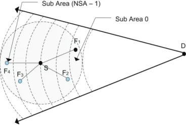
• Area-based scheme. They propose to artificially reduce the forwarding area. The key idea is to define the suppression area in such a way that all nodes within that area are in transmission range of each other, avoiding thus extra packet duplications or collisions as they may appear in the basic suppression scheme. In this direction, the author propose three areas: 1) the basic area defined before, 2) a circle in direction of the destination with the diameter equivalent to the transmission range of the current node. 3) the reuleaux triangle is a shape that better covers the forwarding area and thus offers more forwarding candidate nodes.
• Active Selection scheme. It is inspired by the Request To Send, Clear To Send (RTS/CTS) mechanism from the IEEE 802.11 standard. Here, the forwarding node broadcasts a control packet called RTF (Request To For-ward) instead of immediately broadcasting the packet. The RTF contains the forwarding nodes location and the final destinations location. Each neighbor verify if it is located in the forward progress area, if this is the case, it sets a reply timer according to the progress toward d. Thus, when a timer expiry occurs, a control-packet called CTF (Clear To Forward) is transmitted to the forwarding node and the nodes that hear the CTF sup-press their timers and the current node send finally the packet in unicast to the node which sent the CTF message.
Figure 2.6: Area-based suppression strategies. Node A, B and C are in the reuleaux triangle whereas only node C is in the circle area
2.2.3.3 Implicit Geographic Forwarding (IGF)
Blum et al in [Blum 03], proposed the implicit geographic forwarding where they integrate the routing and MAC layer into a common protocol, taking as basis
the IEEE 802.11 DCF contention scheme. The principle is the same as BLR and CBF; IGF tries to non-deterministically route packets using a competition process between candidate nodes. Compared to the two beaconless protocols explained before, here IGF incorporate an energy remaining (ER) metric into the route selection process. The procedure used to send a packet is the same as the active selection described in CBF (using RTS/CTF control messages, but here they are called ORTS/CTS -Open RTS-). The IGF forwarding area (see Fig. 2.5) is the same as the one of BLR (a 60˚ cone towards the destination). In contrast to CBF, IGF provides a recovery process to bypass the local minimum problem implementing a forwarding area shift where the network layer (previous MAC layer notification) retransmit a message to request a shift in the forwarding area to look for a next hop node and then applies the backpressure from [speed ref]. In Fig. 2.7 we can see the sequence of shifts.
Figure 2.7: Forwarding area sequence shifts in IGF
2.2.3.4 Geographic Random Forwarding (GeRaF)
GeRaF [Zorzi 03], is another type of BLGR that takes the positive advance-ment area of the node coverage area into N sub-regions (see Fig. 2.8). Each of them delimited by the coverage area of the transmitting node and one or two circle areas centered at the sink. Upon forwarding a packet, the sender broad-casts an RTS packet to all nodes in the sub-region closest to the destination and expects a CTS reply. If there is no reply, the sender will broadcast another RTS packet to the sub-region that is the second closest to the destination. This process continues until a CTS is received or all sub-regions have been searched in which case the forwarding fails. When nodes in the same sub-region answer to the RTS packet, a collision may be produced, in this case, the authors adopted the use of busy tones as collision avoidance scheme. The collision avoidance scheme, the
2.2. Geographic Routing Protocols 37 nodes should be equipped with two radios to separate one channel for the data traffic and the other is used as a wakeup signaling.
Figure 2.8: Regions from the destination point of view
2.2.4
New Beaconless Geographic Routing Protocols
In recent times, other extensions to BLGR were proposed, two of them that contribute with new ideas to the routing issue were presented. Beaconless On demand Strategy (BOSS) [Sanchez 07], extend the positive advancement subdi-visions as GeRaf propose to the negative advancement area (see Fig. 2.9) and thus, the shift from ”greedy” mode to recovery mode is automatically. In addition, they studied the impact of the packet size on the packet reception rate by means of some practical experimentations. Kalosha et al [Kalosha 08], proposed two al-gorithms used during the beaconless recovery process. The Beaconlees Forwarder planarization (BFP) and the angular relaying, these contributions planarize the neighborhood to allow the face routing following the beaconless principle to min-imize the overhead of control messages.
2.2.4.1 Beaconless On Demand Strategy for Geographic Routing in Wireless Sensor Networks (BOSS)
As stated in the above section, BOSS [Sanchez 07] considered during its design the physical layer and defined a delay function in order to mitigate the collisions and duplicate packets from the next hop forwarding selection. Based on some experimentations, they found as others before that the packet size has a direct relationship with the probability of error. As big packets have less probability of being received than small packets, the authors decided to avoid the use of RTS/CTS control packets to start the communication between the forwarding node i toward i + 1 node since control packets may induce to select a node that in fact, it may not receive the bigger data packet. To transmit a packet, BOSS uses a three way handshake. The node detaining the packet to send broadcasts it and waits for the first response from the neighborhood and then, they confirm the
selection with a final control packet. To reduce the overhead, they use a passive acknowledgement scheme to confirm the successful reception of the transmitted packet. In case of nodes absence in the positive forwarding area, transparently the nodes located a the negative forwarding area form a planar subgraph where the face routing algorithm is applied to avoid the holes in the network.
Figure 2.9: BOSS extends the positive sub-regions from GeRaf to the negative area of the node coverage area
2.2.4.2 Select and Protest-based Beaconless Georouting with guaran-teed delivery
Kalosha et al [Kalosha 08], based on three select and protest principle, they proposed two methods in the recovery mode to build a planar subgraph that allows the direct application of the face routing algorithm and thus guarantee the delivery of the packet to the destination. In the first contribution called Beaconless Forwarder Planarization (BFP), they build an approximation of a planar subgraph, then they sort out the false nodes from that approximation to get a final planar subgraph used in the beaconless recovery mode. In the second contribution called, the angular relaying, they try to directly find the next hop node of the right-hand face traversal algorithm where if the selected neighbor does not belong to the planar subgraph, in this case the Gabriel Graph, the mechanism look for a consecutive neighbor in the right-hand direction. Given this facts, we can say that the authors proposed two mechanisms to route in recovery mode building planar or partially planar subgraphs minimizing the control messages exchange between the neighborhood and the node detaining the packet to forward.
2.3. Virtual Coordinates 39
2.3
Virtual Coordinates
In previous sections, we have presented the geographic routing as one of the most efficient and scalable routing solutions since it is stateless and localized: it does not need to recognize the topology of the network. To achieve this, each node in the network must know its own coordinates and the destination coordinates. Such approach presents some drawbacks like the localization error that generates routing problems that could increase the path length or minimize the packet delivery rate. Many sensor nodes do not have a Global Positioning System (GPS) embedded and providing such device to each node could be expensive in terms of energetic resources and money, and finally the network can not be deployed for indoor applications. Another kind of study was then derived taking the greedy forwarding principle of geographic routing protocols, but the greedy routing is executed by encoding the connectivity without geographical information, trying to model the network as a geometric space and characterize the position of a node by a position in this space. Thus, the main idea is to build a virtual coordinates scheme that replaces the real physical coordinates. Hence, each node with these coordinates uses a predefined function to calculate the distance between itself and its neighbors. Based on these distances, the greedy forwarding is applied similarly to the traditional geographic routing protocols.
In this section, we present some important virtual coordinates protocols. Since commonly the virtual coordinates system construction is based on few nodes of the network (often called anchors or landmarks) that initialize the process. We present a very first classification based on their behavior. Hence, the protocols may belong to one of two categories: the first when the landmarks are location-aware and the second where the landmarks do not know its coordinates (they are location-unaware).
2.3.1
Location-aware landmarks
The protocols in this category use some landmark nodes who know their physi-cal coordinates, and from these landmarks, the rest of the nodes infer their coordi-nates. To do this, the ordinary nodes execute some physical measurements and/or some localization protocols such as triangulation and multi-lateration methods which are helped by other techniques to determining distances between the nodes, including Received Signal Strength (RSS), Time of Arrival (ToA), Angle of Ar-rival (AoA). This kind of protocols are not considered in the present work since they are designed just to locate a node in a place and then, another protocol is applied to route the information. Refer to [Niculescu 04], [Langendoen 05] and [Savarese 01] for more information.
2.3.2
Location-unaware landmarks
This kind of protocols do not try to approximate their physical coordinates, since the landmark nodes do not know their physical coordinates. They rather relax this constraint and build a virtual system that encodes some network con-nectivity information instead of physical proximity. Hence, once the system is built, the greedy forwarding is used over the virtual coordinates to route the packets.
In this category NoGeo [Rao 03] based on the graph embedding concepts propose to designate two landmarks, then perimeter nodes are detected and pro-jected in a virtual circle to compute their own coordinates, and finally the non landmark nodes calculate their virtual coordinates executing an iterative rubber band algorithm based on a centroid transformation. NoGeo is relatively complex as it requires a large amount of messages exchanges and iterations to converge. In addition to these drawbacks, they assumed that the network is static once the perimeter nodes are detected which trends to problems when new nodes appear. Graph EMbedding for sensor networks (GEM) [Newsome 04] proposes a vir-tual coordinate system with polar coordinates (given in radius and angle from a center). They first create the virtual coordinates system by constructing a span-ning tree, then the radius of each node is defined (number of hops from a node and the root), next each node is assigned an angle range (to identify the node within a level) which will be respectively used to assign an angle range to its subtree. Afterward, each subtree calculates its center of mass and propagates it to the root of the original spanning tree, resulting in a labeled graph tree with virtual coordinates. At this moment, the routing process can be effectuated either by routing up in the tree until a node has been found that is a common parent of both source and destination or using a more efficient scheme called Virtual Polar Coordinate Routing (VPCR). Instead of always routing up the tree, VPCR checks to see if there is a neighboring node with similar radius that is angularly closer to the destination than the current node. If so, that node is given prefer-ence; if not, the packet is routed up the tree. Once an ancestor of the destination is reached, the packet is routed downward just like in the simple routing scheme. Later on, several research works appears, such as Logical Coordinate Space Routing (LCR) [Cao 04], Beacon Vector Routing (BVR) [Fonseca 05], Virtual Coordinate Assignment Protocol VCap [Caruso 05], and HopID [Zhao 05b]. They all have very similar behaviors: 1) Select few landmark nodes and span a tree from them to every node in the network; 2) Each node constructs its virtual coordinates using a vector (see Fig. 2.10) that represent the hop distance to each landmark 3) A distance metric is defined so as to apply it when forwarding the packets. In summary we can say that, first each node derive its virtual coordinates, and then applies the forwarding rule. The small difference between these works can be
2.3. Virtual Coordinates 41 found in the number of landmark nodes used, LCR defines four landmarks, BVR between ten ant eighty, and Vcap tree. Other dissimilarity is the technique used to avoid the loops in the routing path. BVR is the only protocol implemented in real sensor nodes and also while the other mentioned protocol defined the Euclidean distance as function as forwarding criteria, BVR applies the semi-Manhattan distance. Liu et al, stated later that neither the Manhattan nor semi-Manhattan distance are necessary better measures than Euclidean distance.
Figure 2.10: The node P builds its virtual coordinates vector using the three landmark nodes (yellow)
In [Liu 08] Liu et al described an anomaly of the previous protocols since the integral nature of the coordinate vector (virtual coordinates are based on integer number of hops to the anchors) produces a quantization noise in the estimate of connectivity and node location. They improved the performance by proposing an Aligned Virtual Coordinate System (AVCS). To achieve this, they align the nodes by computing the coordinates of a given node as a function of its own coordinates and the coordinates of the neighboring nodes. This new process allows the discrimination between nodes located at the same level of distance between the conflicting nodes and the landmarks.
Leon in [Leong 07] described the Greedy Embedding Spring Coordinates (GSpring) protocol inspired from the physical spring system with repulsion forces model. The model used points to an incremental adjusting of the initial virtual coordi-nates. In GSpring, each link is modeled like a spring by assigning forces among the set of edges between the nodes using the Hooke’s law. The forces are applied to the nodes, pulling them closer together or pushing them further apart. This is repeated iteratively until the system comes to an equilibrium state. At the be-ginning, GSpring detects some perimeter nodes that will act like landmarks and assign them some coordinates, afterward, the rest of the nodes (ordinary nodes) compute their initial virtual coordinates. Then, the ordinary nodes update its co-ordinates based on the virtual coco-ordinates of its direct neighbors using the spring model.