AbstrAct
this report of the swiss seismological service summarizes the seismic activity in switzerland and surrounding regions during 2008. During this period, 451 earthquakes and 75 quarry blasts were detected and located in the region un-der consiun-deration. the three strongest events occurred in the Valais, near Lac des toules (ML 3.6), and in Graubünden, near Ilanz (ML 3.7) and Paspels (ML
4.0). Although felt by the population, they were not reported to have caused any damage. However, with a total of only 15 events with ML ≥ 2.5, the seismic
activity in the year 2008 was far below the average over the previous 33 years.
ZusAmmenfAssunG
Dieser bericht des schweizerischen erdbebendienstes stellt eine Zusammen-fassung der im Vorjahr in der schweiz und umgebung aufgetretenen erd-beben dar. Im Jahr 2008 wurden im erwähnten Gebiet 451 erderd-beben sowie
75 sprengungen erfasst und lokalisiert. Die drei stärksten beben haben sich im Wallis, in der nähe des Lac des toules (ML 3.6) sowie in Graubünden bei
Ilanz (ML 3.7) und Paspels (ML 4.0) ereignet. mit nur 15 beben der
magni-tude ML ≥ 2.5, lag die seismische Aktivität im Jahr 2008 jedoch weit unter dem
Durchschnitt der vorhergehenden 33 Jahre.
résumé
Le présent rapport du service sismologique suisse résume l’activité sismique en suisse et dans les régions limitrophes au cours de l’année 2008. Durant cette période, 451 tremblements de terre et 75 tirs de carrière ont été détectés et localisés dans la région considérée. Les trois évenements les plus forts ont eu lieu en Valais, près du Lac des toules (ML 3.6) ainsi que dans les Grisons
près d’Illanz (ML 3.7) et près de Paspels (ML 4.0). Avec seulement 15
événe-ments de magnitude ML ≥ 2.5, l’activité sismique de l’année 2008 est inférieure
à la moyenne des 33 années précédentes.
Introduction
Past earthquake activity in and around switzerland has been
documented in an uninterrupted series of annual reports from
1879 until 1963 (Jahresberichte des Schweizerischen
Erdbe-bendienstes
). three additional annual reports have been
pub-lished for the years 1972–1974. these reports together with
historical records of earthquakes dating back to the 13th
cen-tury have been summarized by Pavoni (1977) and provided
the basis for the first seismic hazard map of switzerland
(sä-gesser & mayer-rosa 1978). With the advent of routine data
processing by computer, the wealth of data acquired by the
nationwide seismograph network has been regularly
docu-mented in bulletins with detailed lists of all recorded events
(Monthly Bulletin of the Swiss Seismological Service). since
1996, annual reports summarizing the seismic activity in
swit-zerland and surrounding regions have been published in the
present form (baer et al. 1997, 1999, 2001, 2003, 2005, 2007;
Deichmann et al. 1998, 2000a, 2002, 2004, 2006, 2008). In the
course of reassessing the seismic hazard in switzerland, a new
uniform earthquake catalog covering both the historical and
instrumental periods has been compiled (fäh et al. 2003). the
data in the new earthquake catalog of switzerland (ecOs)
are available on line (http://www.seismo.ethz.ch, swiss
earth-quake catalogs). the new seismic hazard map of switzerland
based on this catalog was officially released in 2004 (Giardini
et al. 2004; Wiemer et al. 2009). In addition, numerous studies
covering different aspects of the recent seismicity of
switzer-land have been published in the scientific literature (for an
overview and additional references see, e.g. Deichmann 1990;
Pavoni & roth 1990; rüttener 1995; rüttener at al. 1996;
Pa-voni et al. 1997; Deichmann et al. 2000b; Kastrup et al. 2004;
Kastrup et al. 2007).
Data acquisition and analysis
Seismic stations in operation during 2008
the swiss seismological service operates two separate
nation-wide seismic networks, a high-gain broad-band seismometer
earthquakes in switzerland and surrounding regions during 2008
N
icolasD
eichmaNN, J
ohNc
liNtoN, s
tephaNh
useN, F
loriaNh
asliNger, D
oNatF
äh,
D
omeNicog
iarDiNi, p
hilippK
ästli, u
rsK
raDolFer, i
rism
arschall& s
teFaNW
iemerKey words: earthquakes, focal mechanisms, moment tensors, switzerland
1661-8726/09/030505-10
DOI 10.1007/s00015-009-1339-8
birkhäuser Verlag, basel, 2009
swiss J. Geosci. 102 (2009) 505–514
network and a low-gain accelerograph network. the former
is designed to monitor continuously the ongoing earthquake
activity down to magnitudes well below the human perception
threshold, whereas the latter is principally aimed at
engineer-ing concerns and thus only records so-called strong motions.
beginning in 2003, efforts are underway to merge these two
networks and to record the strong-motion signals continuously
and in real-time together with the high-gain signals. first, 12
sta-tions of the high-gain broad-band network have been equipped
with an additional accelerometer. then as of 2006, 10 sites of
the existing accelerometer network as well as several new sites
have been equipped with modern sensors and digitizers
featur-ing higher dynamic range, broader frequency bandwidth and
higher sensitivity (baer et al. 2007).
to monitor with greater precision an ongoing sequence
of earthquakes in the immediate vicinity of the southern
seg-ment of the new Gotthard railway tunnel that is still under
construction, a set of eight stations with short-period
seismo-meters and in part with three-component acceleroseismo-meters were
installed during the late fall of 2005 in the region between the
Lukmanier Pass and the Leventina Valley. moreover, two
ac-celerometers have been installed in the tunnel itself. At the
beginning of 2008, an additional broad-band station (PIOrA)
was put into operation a few km north of this local network to
monitor more closely potential seismicity associated with the
northward progress of the tunnel construction. these eleven
stations are operated under a contract with
Alptransit-Gott-hard AG.
In the course of 2006 an additional array of seismic sensors
was installed in six boreholes at depths between 317 and 2740 m
below basel. this array was designed to monitor the seismicity
induced by the injection of large quantities of water at high
pressure into a 5 km deep well in the context of a project
initi-ated by Geopower basel AG, a private/public consortium, to
extract geothermal energy. the borehole array is operated by
Geothermal explorers Ltd in Pratteln.
A complete list of the available stations in switzerland and
maps with the station locations of the national network as well
as of the two local networks in the area of basel and in the
Gotthard region can be found in the annual report for 2006
(baer et al. 2007). the only changes to the network with
re-spect to 2006 are the removal of two borehole sensors in the
basel area during the course of the summer 2007 (rIeH2 and
Oter1 – see figure 2 of baer et al. 2007), the installation of an
additional strong-motion station (sfrA) in frenkendorf (bL)
at the beginning of December 2007, and, as mentioned above,
the integration of station PIOrA into the Gotthard network at
the beginning of 2008.
to improve the reliability of locations for events at the
pe-riphery or outside of switzerland, we are engaged in an ongoing
cross-frontier cooperative effort to exchange seismic data in
realtime. since 2005 we continuously record and archive signals
from stations in Austria operated by the Zentralanstalt für
me-teorologie und Geodynamik in Vienna (ZAmG) and in Italy
operated by the Istituto nazionale di Geofisica e Vulcanologìa
in rome (InGV), by the Istituto di Geofisica, università di
Genova and by the Zivilschutz der Autonomen Provinz
bozen-südtirol (baer et al. 2007). the number of observed stations
in-creases as new high-quality stations come on-line in the border
region. In 2008, we have gained real-time access to the stations
KIZ, Gut and bfO in southern Germany.
Hypocenter location, magnitude and focal mechanisms
since the year 2005, hypocenter locations of most of the
lo-cal earthquakes have been determined using the software
package nonLinLoc (Lomax et al. 2000). the P-wave velocity
model used was derived from a 3D tomographic inversion of
local earthquake data with constraints from controlled source
seismics (Husen et al. 2003), and the s-velocities are calculated
from the P-velocity using a Vp/Vs ratio of 1.71.
Local magnitudes (M
L) are calculated from the maximum
amplitude of the horizontal components of the digital
broad-band seismograms filtered to simulate the response of a
Wood-Anderson seismograph. the attenuation with epicentral distance
is accounted for by an empirically determined relation
(Kra-dolfer & mayer-rosa, 1988). the final magnitude corresponds
to the median value of all individual station magnitudes.
for the stronger events, the traditional determination of
fo-cal mechanisms from the azimuthal distribution of first-motion
polarities (faultplane solutions) is complemented by moment
tensors based on a full-waveform inversion. this procedure,
based on a time domain inversion scheme developed by
Dre-ger (2003), also provides a moment magnitude, M
w, the best
fitting double couple, and an optimal depth estimate based on
the given location.
A more detailed documentation of the data analysis can be
found in previous annual reports (Deichmann et al. 2006, baer
et al. 2007).
Seismic activity during 2008
Overview
During 2008, the swiss seismological service detected and
lo-cated 451 earthquakes in the region shown in figure 1. based
on such criteria as the time of occurrence, the location, the
sig-nal character or on direct communication, 75 additiosig-nal seismic
events were identified as quarry blasts.
magnitude values of the events recorded in 2008 range
from M
L0 to 4.0. the events with M
L≥ 2.5 and the criteria
used to assign the quality rating for the given locations as well
as the corresponding estimated location accuracy are listed in
tables 1 and 2.
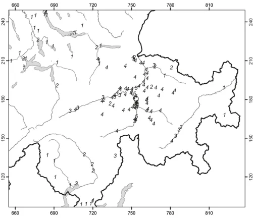
figure 3 shows the epicenters of the 822 earthquakes with
M
L≥ 2.5, which have been recorded in switzerland and
sur-rounding regions over the period of 1975–2008. these events
represent about 8% of the total number of events detected
dur-ing that time period in the same area. the chosen magnitude
threshold of 2.5 ensures that the data set is complete for the
given period and that the number of unidentified quarry blasts
and of badly mislocated epicenters is negligible.
Significant earthquakes of 2008
Paspels
the strongest earthquake in switzerland and surroundings
dur-ing 2008 occurred on January 21st at 17 : 40 local time. Its
magni-tude was M
L4.0 (M
w3.7) and its epicenter was located near the
village of Paspels, 6–7 km n of thusis (Gr). epicentral
inten-sity reached IV-V and it was clearly felt all over southeastern
switzerland (figure 4). three instruments of the strong-motion
fig. 1. epicenters and focal mechanisms of earth-quakes recorded by the swiss seismological ser-vice during 2008. epicenters of events mentioned in the text are Val bavona (ba), Ilanz (Iz), Lac des toules (to) and Paspels (Pa).
6˚ 6˚ 7˚ 7˚ 8˚ 8˚ 9˚ 9˚ 10˚ 10˚ 46˚ 46˚ 47˚ 47˚ 50 km Iz Pa Pa Ba To
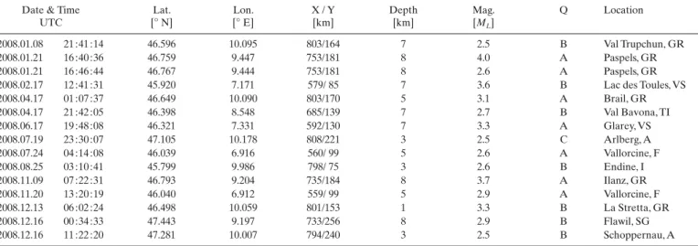
table 1. earthquakes with ML>2.5.
Date & time utc Lat. [° n] Lon. [° e] X / Y [km] Depth [km] mag. [ML] Q Location 2008.01.08 21 : 41 : 14 46.596 10.095 803/164 7 2.5 b Val trupchun, Gr 2008.01.21 16 : 40 : 36 46.759 9.447 753/181 8 4.0 A Paspels, Gr 2008.01.21 16 : 46 : 44 46.767 9.444 753/181 8 2.6 A Paspels, Gr
2008.02.17 12 : 41 : 31 45.920 7.171 579/ 85 7 3.6 b Lac des toules, Vs
2008.04.17 01 : 07 : 37 46.649 10.090 803/170 5 3.1 A brail, Gr 2008.04.17 21 : 42 : 05 46.398 8.548 685/139 7 2.7 b Val bavona, tI 2008.06.17 19 : 48 : 08 46.321 7.331 592/130 7 3.3 A Glarey, Vs 2008.07.19 23 : 30 : 07 47.105 10.178 808/221 3 2.5 c Arlberg, A 2008.07.24 04 : 14 : 08 46.039 6.916 560/ 99 5 2.6 A Vallorcine, f 2008.08.25 03 : 10 : 41 45.799 9.986 798/ 75 3 2.6 b endine, I 2008.11.09 07 : 22 : 31 46.793 9.204 735/184 8 3.7 A Ilanz, Gr 2008.11.20 13 : 20 : 19 46.040 6.912 559/ 99 5 2.9 A Vallorcine, f 2008.12.13 06 : 02 : 24 46.498 10.059 801/153 1 3.3 b La stretta, Gr 2008.12.16 00 : 34 : 33 47.443 9.197 733/256 8 2.9 b flawil, sG 2008.12.16 11 : 22 : 20 47.281 10.007 794/240 3 2.5 b schoppernau, A
table 2. criteria and location uncertainty corresponding to the quality rating (Q) of the hypocentral parameters in table 3. GAP = largest angle between epicenter and two adjacent stations; Dm = minimum epicentral distance; H = horizontal location; Z = focal depth.
rating criteria uncertainty
Q GAP (degrees) (km) Dm (km) H (km) Z A b c D ≤ 180 ≤ 200 ≤ 270 > 270 ≤ 1.5 × Z ≤ 25 ≤ 60 > 60 ≤ 2 ≤ 5 ≤ 10 > 10 ≤ 3 ≤ 10 > 10 > 10
network situated at epicentral distances of 9 to 13 km were
trig-gered by the quake and recorded peak horizontal ground
ac-celerations between 0.21 and 0.34 m/s
2.
this earthquake was part of a sequence of 32 events that
started in August 2007 and continued throughout the year 2008
(figure 5). shortly after the mainshock, a temporary
seismo-graph was installed in the immediate epicentral area. between
January 26th and 30th, this instrument recorded four
after-shocks (0.5 ≥ M
L≤ 1.5) that were detected also by the national
network out to epicentral distances of 70–80 km.
With epicentral distances of about 1 km and travel-time
differences between the s- and P-arrivals of about 1 s at this
temporary station, the focal depths calculated for these four
aftershocks vary between 8 and 9 km. this is in good
agree-ment with the value of 7 km obtained for the mainshock from
the routine location based on the 3D velocity model. As can
be seen from the good agreement between the relative travel
times of the reflections at the crust-mantle boundary (moho)
observed at station WILA (figure 6), the focal depth of the
mainshock and the first of the four aftershocks recorded by
the temporary station must be practically identical. to
calcu-late the take-off angles of the rays at the source for the
fault-plane solution, we fixed the focal depth of the mainshock at
8 km.
the resulting focal mechanism is somewhat unusual, with
one near-vertical e–W striking nodal plane and one n–s
striking nodal plane dipping rather flatly to the e (figure 7).
the unusual dip of the latter is well-constrained by the
down-ward polarities of Pn refractions at the moho observed at
numerous stations in southeastern Germany. moreover, the
general type of mechanism is also matched by the result of
the full-waveform moment tensor inversion, although, as
listed in table 3, the orientation of the P-axes differs by 20
degrees.
fig. 3. epicenters of earthquakes with magni-tudes ML≥ 2.5, during the period 1975–2008.
6˚ 6˚ 7˚ 7˚ 8˚ 8˚ 9˚ 9˚ 10˚ 10˚ 46˚ 46˚ 47˚ 47˚ 50 km
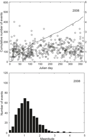
fig. 2. earthquake activity during 2008: magnitude of each event and cumula-tive number of events (above); histogram of magnitudes (below).
Magnitude Number of events 120 100 80 60 40 20 0 0 1 2 3 4 5 2008 0 50 100 150 200 250 300 350 0 1 2 3 4 5 6 600 500 400 300 200 100 0 Cumulative number of events Julian day Magnitude 2008
Lac des Toules
On february 17th at 13 : 41 local time an earthquake with M
L3.6 occurred in the region between bourg saint Pierre and the
col du Grand saint bernard. the epicenter was located about
3 km west of Lac des toules. the calculated focal depth of 7 km
is poorly constrained, and the distribution of travel-time
resid-uals and a qualitative assessment of the waveform character at
the closer stations suggest that it could be shallower. A shallow
focal depth would also be in agreement with the relatively few
reports of it having been felt beyond the immediate
epicen-tral area and with the focal depth of 5 km obtained from the
full-waveform inversion for the moment tensor (figure 8). the
faultplane solution and the best double couple moment tensor
match each other to within 10 degrees (table 3). the resulting
focal mechanism corresponds either to dextral strike-slip
mo-tion on a n–s striking and flatly inclined fault or to obliquely
upward directed slip on a steeply dipping, WnW–ese striking
fault. the extensional axis is inclined at more than 30 degrees
and is oriented in a nnW–sse direction. for the Penninic
domain of the Valais, which is otherwise known for its normal
faulting regime with flat-lying t-axes (e.g Kastrup et al. 2004),
this focal mechanism is rather unusual.
Val Bavona
With a magnitude M
L2.7, the earthquake that occurred on April
17th at the upper end of Val bavona, in northern ticino, was not
particularly significant in itself. However it is part of a sequence
of 29 events with M
Lbetween 0.6 and 2.7 that occurred in a
region which is not known for its seismic activity. About half
of the events in this sequence were detected only by the local
network installed in the Gotthard region and their signals were
integrated into the seD data archive at a later stage. the first
event of this sequence was recorded on february 4th and most
fig. 5. cumulative number of events and event magnitudes of the Paspelssequence. 2007/07/010 2007/12/31 2008/07/01 2008/12/310 10 1 20 2 30 3 40 4 Cumulative number of events Magnitude
fig. 4. macroseismic intensities (ems98) for the ML 4.0 event near Paspels (Gr). the swiss
carte-sian coordinates are labeled in km.
12 0 15 0 18 0 21 0 24 0 660 690 720 750 780 810 660 690 720 750 780 810 660 690 720 750 780 810 660 690 720 750 780 810 12 0 15 0 18 0 21 0 24 0
of the events occurred during the months of february, march
and April, but activity persisted through to December.
Ilanz
In the morning of november 9th (08 : 22 local time) the area
around Ilanz (Gr) was jolted by an earthquake with M
L3.7.
the epicenter of the earthquake, which was felt throughout
northern Graubünden, Glarus and parts of uri, was located
about 2 km n of Ilanz (figure 9). since the nearest station
(LLs) is located at an epicentral distance of 16 km, the
rou-tinely calculated focal depth of 4 km is not well constrained.
Lacking observations from stations close to the epicenter,
calculated focal depths are constrained mainly by arrivals
re-fracted (Pn) or reflected (PmP) at the moho. However, the
results, particularly for shallow sources, are very sensitive to
the crustal velocity model and the assumed moho topography.
the Paspels earthquake of January 21st, 2008, with its
epicen-ter only 15 km east of Ilanz and with its well-constrained
fo-cal depth, offers a unique opportunity to fo-calibrate the
veloc-ity model and thus to determine the focal depth of the Ilanz
quake relative to that of the Paspels event by means of 2D
fig. 6. (a) seismograms of the ML 4.0 mainshock (above) and the ML 1.3af-tershock of 2008/01/26 06 : 16 (below) recorded at station PLOns (epicentral distance 33 km, azimuth 350 degrees), band-pass filtered 1–10 Hz. (b) seismo-grams of the same two events recorded at station WILA (epicentral distance 84 km, azimuth 331 degrees), band-pass filtered 2–10 Hz. both pairs of traces are aligned with respect to the Pg arrival times at station PLOns. the nearly identical travel times of the sg phase at PLOns and of the PmP phase at WILA for the two events show that their sources must be located at similar depths. -1 0 1 2 3 4 5 6 7 seconds 8 9 10 11 12 13 14 15 16 seconds
(a)
(b)
WILA
PLONS
Pg
Sg
Pg
PmP
fig. 7. faultplane solutions based on first-motion polarities (above) and op-timal double-couple moment tensors based on full-waveform inversion (be-low). All stereographs are lower hemisphere, equal area projections. solid circles and shaded quadrants correspond to compressive first motion (up); empty circles and white quadrants correspond to dilatational first motion (down).Paspels
2008.01.21 Lac des Toules2008.02.17 2008.11.09Ilanz
fig. 8. recorded signals (continuous lines) and synthetic seismograms (dashed lines) used for the calculation of the moment tensor of the Lac des toules event shown in figure 7.
Tangential Radial Vertical
DIX_f.05.data, VR=78.7, Max Amp=1.04e-04cm Dist=26.6km, Az=45.3, Zcor=4
MMK_f.05.data, VR=79.3, Max Amp=4.57e-05cm Dist=64.0km, Az=75.8, Zcor=7
AIGLE_f.05.data, VR=77.6, Max Amp=5.15e-05cm Dist=50.4km, Az=341.4, Zcor=6
EMV_f.05.data, VR=72.2, Max Amp=6.12e-05cm Dist=26.5km, Az=309.5, Zcor=4
SENIN_f.05.data, VR=75.6, Max Amp=6.01e-05cm Dist=51.1km, Az=11.7, Zcor=7
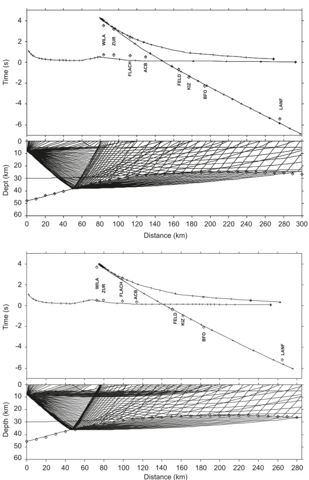
ray tracing. ray trace models for both earthquakes were
con-structed based on the moho model of Waldhauser et al. (1998)
for an azimuth of 320 degrees, equivalent to a nW direction
with respect to both Paspels and Ilanz. figure 10 shows the
ray-tracing results for these two earthquakes, assuming a
fo-cal depth of 8 km for the Paspels event. travel times for the
Ilanz event were calculated for several focal depths between
4 and 9 km. the best match of the Pn travel times at stations
feLD and KIZ, southern Germany, was obtained at the same
focal depth for both events. thus, for determining the focal
mechanism of the Ilanz event, the take-off angles were
calcu-lated with a source depth fixed at 8 km. Given the large
num-ber of azimuthally well-distributed stations that recorded this
event, the faultplane solution is well constrained. the result
is a strike-slip mechanism with nnW–sse and ene–WsW
striking nodal planes (figure 7).
Discussion
In 2008, as in previous years, most of the earthquakes,
includ-ing the 6 events with M
L>
3, occurred in the Valais and in
Graubünden. routinely calculated focal depths for all but 10
events recorded in 2008 are less than 16 km. All the deeper
hypocenters, with a maximum depth of 27 km, are below the
molasse basin and Jura of northern switzerland and southern
Germany. Of the 451 earthquakes recorded in 2008, 29 were
part of the Val bavona sequence and 19 were part of the
Pas-pels sequence. the seismic activity induced by the geothermal
project in basel in 2006 and 2007 (e.g. Deichmann & ernst
2009; Deichmann & Giardini 2009) continued to decrease
over the year 2008, and the events that have been recorded by
the local borehole seismometers were too weak to be detected
by the national broad-band network. the total number of only
table 3. focal mechanism parameters based on first-motion polarities (lines with ML) and on an automated full-waveform inversion method (lines with Mw).Location Date & time
[utc]
Depth [km]
mag. Plane 1 Plane 2
strike/Dip/rake
P-Axis t-Axis Az/Dip Paspels
Lac des toules Ilanz 2008/01/21 16 : 40 2008/02/17 12 : 42 2008/11/09 07 : 22 8 11 7 5 8 ML 4.0 Mw 3.7 ML 3.6 Mw 3.4 ML 3.7 345/38/–015 087/81/–127 007/29/ 000 098/90/–119 002/46/ 169 100/82/ 045 358/56/ 169 094/81/ 034 163/58/–001 254/89/–148 322/42 205/27 342/38 214/38 223/23 331/36 222/16 322/30 123/23 024/21 fig. 9. macroseismic intensities (ems98) for the ML 3.7 event near Ilanz (Gr). the swiss cartesian
coordinates are labeled in km.
660 690 720 750 780 810 660 690 720 750 780 810 660 690 720 750 780 810 660 690 720 750 780 810 12 0 15 0 18 0 21 0 24 0 12 0 15 0 18 0 21 0 24 0
fig. 10. comparison of the 2D ray tracing models for the Paspels (above) and the Ilanz earthquakes (below), assuming a focal depth of 8 km for the Ilanz earth-quake. the time axes are plotted with a reduction velocity of 6 km/s.
Distance (km)
Distance (km)
Dept
(km)
WILA ZUR FLACH ACB FELD KIZ LANF BFO20
20
0
0
0
10
20
30
40
50
60
BFOTime
(s)
WILA ZUR FLACH ACB KI Z FELD LANF0
-2
-4
-6
2
4
40
40
60
60
80
80
100
100
120
120
140
140
160
160
180
180
200
200
220
220
240
240
260
260
280
280
300
Depth
(km)
0
10
20
30
40
50
60
Time
(s)
0
-2
-4
-6
2
4
15 events with M
L≥ 2.5 was far below the 24 to 25 events per
year observed on average over the previous 33 years in this
magnitude category. thus the general trend of lower than
av-erage activity, that started in 2005, persisted through the year
2008.
Acknowledgements
monitoring the seismicity in a small country is not possible without interna-tional cooperation. We thank W. brüstle and s. stange of the erdbebendienst des Landesamtes für Geologie, rohstoffe und bergbau baden-Württemberg in freiburg, who kindly responded to our requests for information and data in 2008. thanks also to r. Widmer and the bundesanstalt für Geologie und rohstoffe, Germany, for enabling access to the data of station bfO. Automatic data exchange in realtime has been implemented with the Zentralanstalt für meteorologie und Geodynamik in Vienna, with the Istituto nazionale di Geofisica e Vulcanologìa in rome and with the Zivilschutz der Autonomen Provinz bozen-südtirol. Access to the data of the borehole sensors in basel was granted by Geopower basel AG, and we thank Geothermal explorers Ltd for their help. We are also very grateful to P. Zweifel and our colleagues in the seD electronics lab for their relentless efforts in ensuring the continuous reliability of the data acquisition systems, and to s. räss and A. blanchard for administrative and logistic support. financial support from the nationale Genossenschaft für die Lagerung radioaktiver Abfälle, nagra, for the opera-tion of the staopera-tions in northeastern switzerland, as well as from Alptransit-Gotthard AG for the operation of the network around the southern segment of the new Gotthard tunnel is gratefully acknowledged. We thank mrs. sa-lome Linder for granting us permission to operate the temporary seismograph at schloss Ortenstein in tumegl and mr. Hans Aliesch for assistance with the installation.
references
baer, m., Deichmann, n., fäh, D., Kradolfer, u., mayer-rosa, D., rüttener, e., schler, t., sellami, s., smit, P. 1997: earthquakes in switzerland and sur-rounding regions during 1996. eclogae Geologicae Helvetiae 90/3, 557– 567.
baer, m., Deichmann, n., ballarin Dolfin, D., bay, f., Delouis, b., fäh, D., Giar-dini, D., Kastrup, u., Kind, f., Kradolfer, u., Künzle, W., röthlisberger, s., schler, t., sellami, s., smit, P., spühler, e. 1999: earthquakes in switzer-land and surrounding regions during 1998. eclogae Geologicae Helvetiae, 92/2, 265–273.
baer, m., Deichmann, n., braunmiller, J., ballarin Dolfin, D., bay, f., bernardi, f., Delouis, b., fäh, D., Gerstenberger, m., Giardini, D., Huber, s., Kastrup, u., Kind, f., Kradolfer, u., maraini, s., mattle, b., schler, t., salichon, J., sellami, s., steimen, s., Wiemer, s. 2001: earthquakes in switzerland and surrounding regions during 2000. eclogae Geologicae Helvetiae, 94/2, 253–264.
baer, m., Deichmann, n., braunmiller, J., bernardi, f., cornou, c., fäh, D., Giardini, D., Huber, s., Kästli, P., Kind, f., Kradolfer, u., mai, m., maraini, s., Oprsal, I., schler, t., schorlemmer, D., sellami, s., steimen, s., Wiemer, s., Wössner, J., Wyss, A. 2003: earthquakes in switzerland and surrounding regions during 2002. eclogae Geologicae Helvetiae – swiss Journal of Geosciences, 96/2, 313–324.
baer, m., Deichmann, n., braunmiller, J., Husen, s., fäh, D., Giardini, D., Kästli, P., Kradolfer, u., Wiemer, s. 2005: earthquakes in switzerland and surrounding regions during 2004. eclogae Geologicae Helvetiae – swiss Journal of Geosciences, 98/3, 407–418, DOI: 10.1007/s00015-005-1168-3. baer, m., Deichmann, n., braunmiller, J., clinton, J., Husen, s., fäh, D.,
Giar-dini, D., Kästli, P., Kradolfer, u., Wiemer, s. 2007: earthquakes in switzer-land and surrounding regions during 2006. swiss Journal of Geosciences, 100/3, 517–528, DOI: 10.1007/s00015-007-1242-0.
Deichmann, n. 1990: seismizität der nordschweiz, 1987–1989, und Auswer-tung der erdbebenserien von Günsberg, Läufelfingen und Zeglingen. nagra technischer bericht, ntb 90–46, nagra, baden.
Deichmann, n., baer, m., ballarin Dolfin, D., fäh, D., flück, P., Kastrup, u., Kradolfer, u., Künzle, W., mayer-rosa, D., röthlisberger, s., schler, t., sellami, s., smit, P., & Giardini, D. 1998: earthquakes in switzerland and surrounding regions during 1997. eclogae Geologicae Helvetiae 91/2, 237–246.
Deichmann, n., baer, m., braunmiller, J., ballarin Dolfin, D., bay, f., Delouis, b., fäh, D., Giardini, D., Kastrup, u., Kind, f., Kradolfer, u., Künzle, W., röthlisberger, s., schler, t., salichon, J., sellami, s., spühler, e., Wiemer, s. 2000a: earthquakes in switzerland and surrounding regions during 1999. eclogae Geologicae Helvetiae, 93/3, 395–406.
Deichmann, n., ballarin Dolfin, D., Kastrup, u. 2000b: seismizität der nord- und Zentralschweiz. nagra technischer bericht, ntb 00–05, nagra, Wet-tingen.
Deichmann, n., baer, m., braunmiller, J., ballarin Dolfin, D., bay, f., bernardi, f., Delouis, b., fäh, D., Gerstenberger, m., Giardini, D., Huber, s., Krad-olfer, u., maraini, s., Oprsal, I., schibler, r., schler, t., sellami, s., steimen, s., Wiemer, s., Wössner, J., Wyss, A. 2002: earthquakes in switzerland and surrounding regions during 2001. eclogae Geologicae Helvetiae – swiss Journal of Geosciences, 95/2, 249–261.
Deichmann, n., baer, m., braunmiller, J., cornou, c., fäh, D., Giardini, D., Gisler, m., Huber, s., Husen, s., Kästli, P., Kradolfer, u., mai, m., maraini, s., Oprsal, I., schler, t., schorlemmer, D., Wiemer, s., Wössner, J., Wyss, A. 2004: earthquakes in switzerland and surrounding regions during 2003. eclogae Geologicae Helvetiae – swiss Journal of Geosciences, 97/3, 447–458. Deichmann, n., baer, m., braunmiller, J., Husen, s., fäh, D., Giardini, D.,
Kästli, P., Kradolfer, u., Wiemer, s. 2006: earthquakes in switzerland and surrounding regions during 2005. eclogae Geologicae Helvetiae – swiss Journal of Geosciences, 99/3, 443–452, DOI: 10.1007/s00015-006-1201-1. Deichmann, n., baer, m., clinton, J., Husen, s., fäh, D., Giardini, D., Kästli, P.,
Kradolfer, u., Wiemer, s. 2008: earthquakes in switzerland and surround-ing regions dursurround-ing 2007. swiss Journal of Geosciences, 101/3, 659–667. DOI: 10.1007/s00015–008–1304-y
Deichmann, n. & ernst, J. 2009: earthquake focal mechanisms of the induced seismicity in 2006 and 2007 below basel (switzerland). swiss Journal of Geosciences, 102/3; DOI: 10.1007/s00015-009-1336-y.
Deichmann, n. & Giardini, D. 2009: earthquakes induced by the stimulation of an enhanced geothermal system below basel (switzerland). seismo-logical research Letters 80/5, 784–798, doi:10.1785/gssrl.80.5.784. Dreger, D. s. 2003: tDmt InV: time Domain seismic moment tensor
In-Version. In W. H. K. Lee, H. Kanamori, P. c. Jennings, and c. Kisslinger (eds.), International Handbook of earthquake and engineering seismol-ogy, Volume b, pp. 1627.
fäh, D., Giardini, D., bay, f., bernardi, f., braunmiller, J., Deichmann, n., fur-rer, m., Gantner, L., Gisler, m., Isenegger, D., Jimenez, m.-J., Kästli, P., Kog-lin, r., masciadri, V., rutz, m., scheidegger, c., schibler, r., schorlemmer, D., schwarz-Zanetti, G., steimen, s., sellami, s., Wiemer, s., Wössner, J. 2003: earthquake catalog of switzerland (ecOs) and the related ma-croseismic database. eclogae Geologicae Helvetiae – swiss Journal of Geosciences, 96/2, 219–236.
Giardini, D., Wiemer, s., fäh, D., Deichmann, n., sellami, s., Jenni, s. and the Hazard team of the swiss seismological service 2004: seismic Hazard Assessment 2004. swiss seismological service, 81 pp.
Husen, s., Kissling, e., Deichmann, n., Wiemer, s., Giardini, D., baer, m. 2003: Probabilistic earthquake location in complex three-dimensional velocity models: Application to switzerland. Journal of Geophysical research, 108, b2, 2077–2096.
Kastrup, u., Zoback m.-L., Deichmann, n., evans, K., Giardini, D., michael, A. J. 2004: stress field variations in the swiss Alps and the northern Alpine foreland derived from inversion of fault plane solutions. Journal of Geo-physical research,109, b1, doi:10.1029/2003Jb002550b01402.
Kastrup, u., Deichmann, n., fröhlich, A., Giardini, D. 2007: evidence for an active fault below the northwestern Alpine foreland of switzerland. Geophysical Journal International, 169, 1273–1288, DOI: 10.1111/j.1365-264X.2007.03413.x
Kradolfer, u. & mayer-rosa, D. 1988: Attenuation of seismic waves in swit-zerland. In: recent seismological investigations in europe. Proceedings of the XIX General Assembly of the esc. moscow, October 1–6, 1984, 481–488.
Lomax, A., Virieux J., Volant P., thierry-berge, c. 2000. Probabilistic earth-quake location in 3D and layered models. In Advances in seismic event Location, edited by c.H. thurber, and n. rabinowitz, Kluwer Academic Publishers, Dordrecht/boston/London, pp. 101–134.
Pavoni, n. 1977: erdbeben im Gebiet der schweiz. eclogae Geologicae Hel-vetiae 70/2, 351–370.
Pavoni, n. & roth, P. 1990: seismicity and seismotectonics of the swiss Alps. results of microearthquake investigations 1983–1988. In: Deep structure of the Alps. (ed. by f. roure, P. Heitzmann and r. Polino). mémoire de la societé. geologique de france, n.s., 156, 129–134.
Pavoni, n., maurer, H., roth, P., Deichmann, n. 1997: seismicity and seis-motectonics of the swiss Alps. In: Deep structure of the swiss Alps, results of nrP 20, birkhäuser, basel, 241–250.
rüttener, e. 1995: earthquake hazard estimation for switzerland. matér. Géol. suisse, Geophys. nr. 29, schweizerische Geophysikalische Kom-mission, etH-Zürich, 106 pp.
rüttener, e., eogozcue, J., mayer-rosa, D., mueller, s. 1996: bayesian estima-tion of seismic hazard for two sites in switzerland. natural Hazards 14, 165–178.
sägesser & mayer-rosa 1978: erdbebengefährdung in der schweiz. schweize-rische bauzeitung 78/7, 3–18.
Wiemer, s., Giardini, D., fäh, D., Deichmann, n., sellami, s. (2009): Probabi-listic seismic hazard assessment of switzerland: best estimates and un-certainties. Journal of seismology, 13, 449–478, DOI: 10.1007/s10950-008-9138-7.
manuscript received november 3, 2009 revision accepted november 12, 2009 Published Online first December 9, 2009 editorial Handling: s. bucher