Publisher’s version / Version de l'éditeur:
Geological Society of America Bulletin, 77, 1, pp. 15-30, 1966-05-01
READ THESE TERMS AND CONDITIONS CAREFULLY BEFORE USING THIS WEBSITE.
https://nrc-publications.canada.ca/eng/copyright
Vous avez des questions? Nous pouvons vous aider. Pour communiquer directement avec un auteur, consultez la
première page de la revue dans laquelle son article a été publié afin de trouver ses coordonnées. Si vous n’arrivez pas à les repérer, communiquez avec nous à PublicationsArchive-ArchivesPublications@nrc-cnrc.gc.ca.
Questions? Contact the NRC Publications Archive team at
PublicationsArchive-ArchivesPublications@nrc-cnrc.gc.ca. If you wish to email the authors directly, please see the first page of the publication for their contact information.
NRC Publications Archive
Archives des publications du CNRC
This publication could be one of several versions: author’s original, accepted manuscript or the publisher’s version. / La version de cette publication peut être l’une des suivantes : la version prépublication de l’auteur, la version acceptée du manuscrit ou la version de l’éditeur.
For the publisher’s version, please access the DOI link below./ Pour consulter la version de l’éditeur, utilisez le lien DOI ci-dessous.
https://doi.org/10.1130/0016-7606(1966)77[15:AFFNAN]2.0.CO;2
Access and use of this website and the material on it are subject to the Terms and Conditions set forth at
Alluvial fan formation near Aklavik, Northwest Territories, Canada
Legget, R. F.; Brown, R. J. E.; Johnston, G. H.
https://publications-cnrc.canada.ca/fra/droits
L’accès à ce site Web et l’utilisation de son contenu sont assujettis aux conditions présentées dans le site LISEZ CES CONDITIONS ATTENTIVEMENT AVANT D’UTILISER CE SITE WEB.
NRC Publications Record / Notice d'Archives des publications de CNRC:
https://nrc-publications.canada.ca/eng/view/object/?id=8bf680a3-5896-42e6-b76d-6fe554ab73de
https://publications-cnrc.canada.ca/fra/voir/objet/?id=8bf680a3-5896-42e6-b76d-6fe554ab73de
I<. F. LF,GGI37' Di~,isio~l of Bzlilrlitlg Rcsemrcl~, A'(1~iorlc11 Re~e(1rcI2 COIIIICI'I, 0f1(1111(1, Orr~ario, Carlatla
R . J. E. HRO\\'N Soil ibfeclrc~rlics Sec~iorz, Zli~~isiorl of B~~ilrlirrg R e s e c ~ ~ h , ~Vr~tiorznl Resecrrclz Co~~rrcil,
G. 1-1. J O H N S I ' O N Otfa~urt, Orrt~rio, Cnr~arln
Alluvial Fan Formation Near Aklavik,
Northwest Territories, Canada
A b s t r a c t : \\:hen ~ h c Glnatlian <:o\.crnmcn~ dccidctl
to rclocatc ~11c 1on.n o l Xklavik in ~ h c d c l ~ a o l t h e
h4ackenzic Ri\.cr, N o r ~ h \ v c s t 7'errirories: t h e search
l o r n ncn. sitc involved detailed sitc invcsrigations o l l o u r p r o s p c c ~ i v c l o c a ~ i o n s . O n e \v:ls o n t h e g e n ~ l y
sloping surface o l an alluvial lan bctn.ccn ~ h c R i c h -
ardson h 4 o u n ~ a i n s a n d t h e \vestern rim of t h e ~ M a c -
kcnzie D e l t a . P r c d i c ~ i o n s l r o m surficial cvidcncc a n d l r o m a detailccl s t u d y o l a e r i a l p h o ~ o g r a p h s n.ere invalicla~cd \vhcn drilling in t h e perennially lrozcn
g r o u n d discloscd a1 Ic:~st 40 l c e ~ of organic silt and
n o s a n d o r g r a v c l a s hacl bccn espcctccl. T h e a d j a c e n t
m o u n t a i n s of C r c ~ a c c o t ~ s a g e suppl!. rna~cri;lls
crotleti I r o n sandsrone ant1 shales. T h c a c ~ i o n of
lrost probably induces mech:lnical disintcgr:~tion.
? .
I u r b u l c n t stre:lm flow c o n ~ i n ~ ~ c s t h e erosion process,
\vhich appears to b e s ~ i l l f u r t h e r aided by tlle a111ll1a1
g r o w t h of f a s ~ - ~ r o m i n g scdgcs a n d grasses o n ~ h c
surface of t h e s t r e a m mcantlcrs. T h e s h o r t b u t \vilr~n
growing season leads LO r:lpid decay o l this grass
c o v e r ; this c o m b i n e d \vith the a n n u a l layers of
stream-becl matcri:~l r c s u l ~ s in ~ h c [:Ins being coln-
posed prcclominantly of organic silt n i ~ h only m i n o r
quantities of coarse-grained m a ~ c r i a l .
CONTENTS
Introduction . . . 15 5. Envelopes of grain-size distribution curves for
Description of alluvial fans . . . 16 fan soil samples from near i\klavik, Canada 22
Location . . . 15 6. l'lasticity chart Tor alluvial fan soils Trom near
Climate . . . 16 ~\klavik, Canatla. . . 24
Surface f c a ~ i ~ r c s . . . 18 7. Disintegration of rock s:~rnplc from \\,illow fan
Soils . . . 19 gi~lly near .i\l;lavik, C:~n:~da, by freeze- haw
Source of fan matcrial . . . 23 cycling in laboratory . . . 26
1:ormation o l Tans . . . 25
'tion of alluvial Ihns . . . 17
2. I-Iy~hcrgrapholXkli~vik, Can;~tla . . . 18 Table
3. Map of \\,illo\v fan arc;) ncar i\klavik, Canada . 20 1. I'lastici~y ancl activity of soil s;unplcs fro111 alluv-
4. I>ctaile(l soil ~,rolilcs horn :~lluvial Tan boreholes in1 fans near t\ltlavik, North\\~est Tcrri~orics,
In~roduction . . . 25 plaLc I:ollo\\ing
Freczc-th:~\\, tests . . . 25
IN'l'IIoDUC1'IOK t h c i c c c o ~ l t c ~ l t t h e t o w n s i c c t h a t rnalccs t h e soils u ~ l s u i t a b l e o l t h e d c l t a i c soils
underlying
l o rL a t c i n 1953 t h c G o v c r n m c n t o f C a n a d a d c - b u i l d i n g l o u n d a t i o n s , p r o p c r s a ~ l i t a t i o n facilities.
c i d c d t h a t a n e w t o w n s i t c s h o ~ ~ l d b e l o ~ ~ n d f o r a n d a i r s t r i p c o n s t r u c t i o n . D a n g e r r r o m r i v e r
he s e t t l e m c n t o r i l k l a v i l i , N o r t h w c s t T c r r i - flooding a n d t h e l i m i ~ c c l size o l t h e s i t c a d d e d LO
~ o r i c s , s i t u a t c d o n he P e e l C h ~ u n n e l o f ~ h c hIac- t h c local p r o b l c r n s ( M e r r i l l a n d o t h e r s , 1960).
Iccnzic 1)elta. T h i s d c c i s i o ~ l w a s p r o m p t c d by ;I s u r v c y t e a m u l l d c r ~ h c a u s p i c c s o l t h e
Process
,,[
dcposiLion, . , , , , , , , , , . 2 j 1. .Air photograplls of alluvial fans, North\vest '. . .
Disintegration of rna~crinl. . . 27 2. i\llur,ial fans near Aklavik, North\\~est Tcrri- 'l'crritories, Canatla
Conclusion. . . . 28 . . .
Rel'erenccs cited. . . 3. Soarcc of m;~terial torics, Canada. co11ll)rising illhlviaI fz111s 11c:1r
Uibliography . . . Aklavik, North\vest Territories, Canacla . .
12igurc 4. Surf:~cc
. .
of allu\~ial fans near /\ltlnvik, North\vestGeological Society ol'rlmerica Uullctin, v. 77, p. 15-30, 7 figs., 4 pls., J a n u a r y 1966
15
'
IS16 LEGGET AND OTI-IERS-ALI.UVItlL FAN FORMATION. CANhllrZ Dept. of Northern Affairs and National Re-
sources (Canada) was organized during the win- ter of 1953-1954 for thc purpose of selecting a new site and was led by C. L. Merrill of that de- partment. Personnel consisted of engineers and specialists in geography and geology iron1 the staffs of the following Canadian federal depart- ments: Northern Affairs and National Rc- sources, Mines and Technical Surveys, Public Works, Transport, and National Health and Welfare, ancl from the Division of Building Re- search of the National Research Council.
Uncontrolled nlosaics of aerial photographs covering the entire LMaclcenzie Delta and the adjacent uplands were assembled and studied in Ottawa during the winter of 1953-1954. Inten- sive study revealed that several potential sites existed on each side of the delta that merited in- vestigation in the field.
Therefore, during the summer of 1954 de- tailed site investigations mere conducted a t each of the potential townsite areas. One of these areas consisted of a series of coalescing alluvial ians on the west side of the Mackenzie Delta, 12 miles south~vest of Aklavik. Personnel o i the re- location survey team conductcd detailed soils and permafrost investigations on two of the al- luvial fans.
T h e results obtained from this test drillinn "
were unexpected in that the anticipated pre- dominance of sand and gravel usually associated with alluvial fans was 1101 iound. T h e character
of the soil formation thus revealcd
eliminated
this site as a location for the new town, but a t the same time raised questions regarding thc formation of alluvial ians, which the writers have studied since thc original field work was com- pleted and upon which they now report. D E S C R I P T I O N O F ALLUVIAL FANSLocation
T h e coalescing alluvial fans form a plain tilted slightly downward to the east between the Richardson Mountains and the Huslcy Channcl, a secondary cl~annel that flows clown the es- trcrne west side of the Maclcenzie Dclta in northwestern Canada (Fig. 1 ; PI. 1, fig. I). T h e southern extremity of the ~Mackenzie Dclta lies 90 miles north of the Arctic Circle. T h e delta is a low flat arca approsinlately 40 nlilcs wide and 130 miles long, covcring an arca of about 4700 square miles. It consists of silts, with solne fine sand and clay, and is interlaced by Inany rivcr channcls and spotted with thousands o i stag- nant lalces (Macliay 1956; 1963). T h e Richard-
son Mountains rise to approxilnately 2000 fect above sea level on thc western flank of the delta ovcrloolci~~g the alluvial ians. Thirtcen miles to thc soutlleast, a t the southern end of the alluvial plain, the mountains rise to more than 2500 fect. T o the west of this flank they rise to more than 5000 ieet (PI. 1, fig. 1).
T h e fan selected as the most suitablc for a , townsite area is the most northerly of thc co- alescing series and is 1 mile wcst o l the junction o i the Peel and Husky channels. Most of thc ob- servations were made on this fan (hereafter re- -. ierred to as the "~villow fan"; see description o i fan vegetation) which is 1.75 miles long from the apex to the toe and 2.5 milcs wide. Six miles to the south observations were made on another fan (hereafter referred to as the "suruce fan":
see description of ian vegetation) of about the same dimensions.
For more than 30 years there has been a weather station located in the delta a t Alclavik. T h e climate in the region of the alluvial fans may vary slightly from that of Aklavik because of their location a t the base of the Richardson Mountains but it can reasonably be assumed to be very similar to that of Alelavile.
Although the Mackenzie Delta reaches the arctic coast of Canada, its climate is essentially continental in character, with long cold winters and short, alarm summers. Combined with thc low elevation of the Maclcenzie Rivcr vallcy and the protection alTorded by the mountains
to the west, the local climate is one of the fac- tors associatccl with the extension of the tree line in the delta to within 20 milcs o i the arctic coast.
Study of the records (1931-1960) gives the iolloming temperature information :
O F
-
hllean January daily ternperature
-
19.9 Mean January daily minin~umtemperature
-
26.9Mean January daily maximum
temperature - 12.9
Mcan July daily temperature 56.5
Mean July daily ~ n i n i ~ n u n ~
temperature 48.0
Mcan July daily maximum
tclnuera turc 64.9
Mcau annual temperature 15.6
Mean annual minim~un
tcmperat~ire 8.1
Mcan annual nlasimum
DESCRIPTION OF ALLUVIAL FANS 17 Estrcme lowest rccordcd above freezing, giving an avcrage total of 105 temperature since 192 1 -62 days without frost. O n thc avcragc, ho~vevcr, Extremc highest recordcd only 66 of thesc would o c c ~ ~ r in s~~cccssion.
93
temperature since 192 1 T h c oscillation of the air tenlperat~lrc around Particularly notable are the low mean annual the freezing point (32OF) during the year is rc- temperature (in contrast wit11 the Incan July lcvant to thc subject of this paper. Accordiilg to
Figure 1. Map of Macke~lzie Delta, Canada, sho~ving location ol alluv~al lans 4
daily maxi~llunl of 64.9OF), showing clearly the relatively short duration of high summcr and the long duration of the steadily cold nrintcr. At i\lclavilc, thc average frost-frcc period cach summcr is only 66 days, from Junc 15 to August 20. I t has becn as short as 32 days and as long as 102 days. 7'he dates of the last frost in spring and the first frost in autumn vary by about 1 month on cach side of thc avcragc datcs given. During most oS Junc, July, August, and carly September the temperature remains
Fraser (1 959), who suggested that a frceze-thaw cycle is represented by a rise to 34OF follon~ing a drop t o 2g°F, thc avcrage numbcr of frecze-
than1 cycles occurring annually at i\lclavilc is 25. Esamin;~tion of telnperaturc rccords through- out Canada shon~s that thc average annual fre- qucncy of frcczc-thaw cycles decreases steadily ~ v i t h
increasing
latitude through ccntral Cana- da. For csamplc, Rcgina, Sasl<atchcn~an (lat. 31°N.), has : I I ~ annual avcragc of 60 cycles; Fort Smith, Northwest Territories (lat. 60°N.),M A C Y E M Z l . 5 D E L T A D E L T A BOUNDALj)' I N D E E 4 5 T ~ T l O h f 69
2
133 Id 68 "d-
#'has 4 s : ;und I'urek;l, Northivest T'crritorics (lat. avclxgc lcss than
5
~niles per hour. For almostSOON.), has 12. Although tlic annual lrequency hall the time, thc ivind comes lrom thc north o r of freezc-thaw cycles dccrcases to\vard thc north\vcst, blo\\~ing inland from the UeauSort north, the duration of the lreezing part oC thc Se;l, 2nd for about one-third of thc time it is cycle increascs, and the minimum heIo\\~-lrccz- fro111 the south or southeast.
ing tclnpcratures bccomc lower. T h e hythergraph of the climate a t ;\l<lavik is
M E A N M O N T H L Y T O T A L P R E C
I
P I T A T I O N ,
l
N C H E S
Figurc 7. Hythc~.gr:~ph of :\kla\,ik, N o r ~ l i \ \ ~ c s ~ ?'crri~.orics, Can:tcl:~,
.
I hc mean annual prccipitation a t i\klavik is
8.84 inches, tllc mean annual rainlall is 3.90
inches, and tllc mean annual sno\\lfall is 49.4 in- chcs. Rain has never becn rcported in the 4 months from Novcmber to February ancl is rarc in kI;~rch ;lnd :\pril. Snow has fallcn in all months of the year, although it rarely lalls in July.
Aklavik is not very n i n d y comp;~red to thc country as a ivholc. Tlic strongest \\~incls occur in June, \vith an averagc of only 8 ~nilcs per
hour. I n Novcmbcr and Llccember the winds
sho\vn in Figure 2. T h c main features of the cli-
.
m a t e arc thc short, summers; thc long, colcl nintcrs; the lo111 numbcr o l annu211 lrcczc- thaw cyclcs; thc lo\\! aonual precipitation; and the low \ ~ i n d spcccls.P l l Y S I ( : h L GEOI.OGY :\XI) REI.IEF:
?'I~c
\VCSt-crn limit of the I<ce\vatin Icc Shccr appears to have becn in rhe delta arc;), the ice being blocked on the west by the barricr of thc Iiichardson h/Iountains. h~\/loving north along
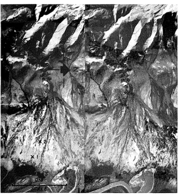
Figure 1. Aerial view of alluvial fans looking south from an altitude of 20,900 feet. Mackenzie Delta on left with meandering Husky Channel a t toe of fans. Note V-shaped valleys in Richardson Mountains on right. Borehole loca- tion shown by x. (RCAF air photo T5-10L, August 1944)
Figure 2. Stereo pair of willow fan situated between Mac- kenzie Delta (bottom of photographs) and Richardson Mountains (top of photographs). (RCAF A 12861-182 and 183) x, borehole location; 1, Hole no. 1 ; 2, Hole no. 2; 3, Hole no. 3
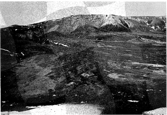
Figure 1. Aerial view of willow fan looking northwest (June 1954)
Figure 2. Ground view of willow fan (August 1954)
ALLUVIAL FANS NEAR AKLAVIK, NORTHWEST TERRITORIES, CANADA
LEGGET AND OTHERS, PLATE 2
Geological Society of America Bulletin, volume
77
I
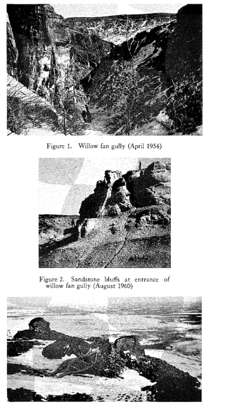
Figure 1. Willow fan gully (April 1954)
Figure 2. Sandstone bluffs a t entrance of willow fan gully (August 1960)
Figure 3. Weathered shale blocks in Richardson Mountains (April 1954)
SOURCE O F MATERIAL COMPRISING ALLUVIAL FANS NEAR AKLAVIK, NORTHWEST T E R R I T O R I E S , CANADA
LEGGET AND OTHERS, P L A T E 3
Figure 1. Stream flowing on willow fan, 2000 feet southeast of Hole no. 3 (May 1954)
Figure 2. Freshly deposited material on willow fan, 2000 feet southeast of Hole no. 3 ( M a y 1954)
S U R F A C E O F ALLUVIAL F A N S N E A R AKLAVIK, N O R T H W E S T T E R R I T O R I E S , CANADA
L E G G E T A N D O T H E R S , P L A T E 4
the trough now occi~picd by the h,lackenzic Delta, rhc icc straightened ancl s ~ n o o t h c d oil' the castcrn scarp o l the rnoun~:~ins. Ilcposits and lancl forms associated wit!] glaciation, such as till, knmcs, moraines, and ~nelt-water chan- nels, abound on the eastern slopes, and erratics occur to elevations o l 3000 lcet abovc the fans. West of the castcrn scarp the rcliel is that of a rolling plateau dissec tcd 11y many V-sh;~ped valleys (Mackay, 1963).
T h e alluvial lans have been formed from dis- integrated and decomposed products Irom the liichardson h~lountains. Both the lans and the surface deposits of the Mackenzie Delta are be- lieved to be
predominantly
postglacial. T\vo distinct p d e s were present o n each o l the lans investigated (Iiiccio, 1962). T h e first, relatively steep, estends from the apes o l the fan domn- \\lard for a distance of Irom one-third t o one- hall the length o l the fan; on the millo\v [an this grade is 1.9 per cent and on the spruce fan, 6.1 per cent. T h e second grade, t o the deltaic deposits a t the toe of the Can, is longer ancl lower; a t the nrillo\v L'nn it is 1.3 per cent and a tthe spruce [an, 7.3 per cent.
VEGET,\TION: T h e low elevation of the hllac- kenzie River valley, \vhich is flanlced by pro-
~ -
tecting mountains over much of its course, favors :I nortlnvard estension of the great
northern coniferous forest into the clelta to about 20 miles south oC the arctic coast. In thc forested part of the delta spruce is dominant; poplar, birch, ancl thic1;ets of alder ancl nrilloiv are also present. In many places, ho\vever, there are open patcl~es o l nleado\vs unable t o support any tree g r o n t h . N o r t h o l the tree line the vegctation consists of mosses, grasses, sedges, and heaths, with widely scartcrcd scrub willow and alder. ~ ~~
T h e tree growth on the \villo\v lan, consisting ol\villo\v and alder thicl;ets u p to 15 feet high, is typical o l the north hall o l the alluvial plain (PI. 2, fig. 2). These tl~icl<ets are interspersed with open meadow-like areas in which sedge (prcdornin;~ntly Crrrex aqrtaiilij LVohl) a n d grass grow to a height o l a b o u t 15 inches in only a lcw weeks every summcr.There are sonleareas of bare (nc\v) soil and an increasing number o l sedge and grass tussocl<s toward the toe of the fan. O t h e r ground plants include Sphagnum and other mosses, lichen (Clrdoni[z TI)., Cetrrzrin sp.), Labrador tea, juniper, blueberry, and \\intergreen. T h e over-all patter11 of the vegeta- tion appcars to trace the past movements of the discharge Iron1 the creek and t h i ~ s intensifies the braided appcarzunce of the fan when vic\\,ed
Iron1 the air or by means o l acri;~l photographs (PI. 1, fig. 7; 1'1. 2, fig. 1).
F.
I he tree g r o ~ v t l ~ on the spruce fan is typical of rhc southern hall of the alluvial plain. Its vegetation is similar to thc \villow [an previously described wirh the addition o l sprucc trees, which reach a m a s i m l ~ m height of 25 feet. 'l'he average height anti density o l the tree gro\\lrh escecds that on the millo\v [an, ancl hence the braided eflect seen I r o n the air is more pro- nounced.
T h e boundary bet\vecn the fans and delta is fairly well delineated by vegctation. 7'his is true even on the spruce-covered Cans where the height and density o l trees are somewhat less than those on the adjacent delta. T h e factors that allow these fans in the south hall o l the alluvial plain to support spruce growth in contrast to the scrub willow and alder gro\vth of the northern lans present a problem beyoncl the scooe of this uaoer. 1 ,
FROST P H B X O X I E S A : T h e ground surfice of all fans is characterized by the following microrelief forms: polygons in local depressions surrounded, or partly surrounded, by raised rims u p to 5 feet in l ~ e i g l ~ t ; complete and p r t i a l polygons about 30 leet in diameter dc- lineated by troughs of depths measurecl in inches; and frost moiunds u p to 5 leet in diam- eter and 1 foot high. T h e r e arc numerous signs o l intensive frost action t l ~ r o u g h o u t the entire Tan area. Large areas contain frost mounds, and polygonal cracks are founcl every- \vhcre. I'crmaCrost is continuous and estcnds to depths o l several hundred leet.
So ils
"
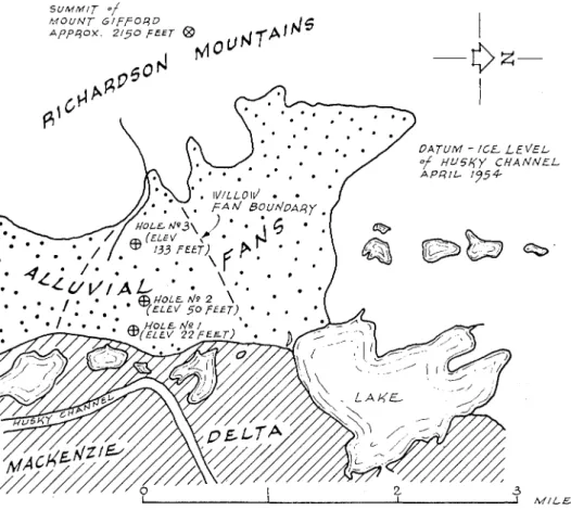
tions were carried o u t by drilling ancl sampling methods (Pihlainen and Johnston, 1954) to obtain undisturbed cores oC the perennially lrozen soils. T h r e e holes were clrilled in the wil- loiv lan a n d one o n the sprucc fan (PI. l , fig. l ; PI. 1, fig. 7; Fig. 3; Pihlainen and others, 1956). Hole no. 1, locatcd a t the toe o l thc ~villon. Can, mas advanced to a d e p t h of 32 leet n ~ i t h core recovery of more than 90 per cent. Drilling dificulties were espericnccd a t Hole no. 2, locutecl part way u p the fan. T w o core barrels froze in a t depths of 5 and 17 feet; samples were obt;~ined only to a cleptl~ of 5 lect, and the hole h ; ~ d to be abandoned in order t o recovcr thc core barrels. Mole no. 3, located near the a p c s of the fan, \V;IS advanced to a d e p t h o l 38 feet wit11 core recovery averaging 50 per cent. I-Iolc no. 4, locatcd near the ~ n i d d l e of the spruce fan.
20 LEGGET AND OTI-IERS-ALLUVIAL FAN FORMATION. CANiZDA
was drilled to a depth of 29 fcet, with core rc- distribution linlits for samples from the top covery avcraging GO per cent. (Detailed soil of this fan show larger particle sizes grading
profiles are shon~n in Fig. 4.) down from approsi~nately the coarse-sand size
TEST RESULTS: Undisti~rbed samples wcrc (lcss tllan 2.0 mm). Samples from the middle of
examincd for ice segregation characteristics, the spruce fan (with a higher surl'ace gradient) and laboratory tests were carried out to identify sho~v a grain-size distribution envelope similar
S U M M I T o f '
Figure 3. Map of willow fall area near Aklavik, North~vcst Tcrritorics, Canada the various soils found. Although the observa-
tions rcported in this paper pertain mainly to the ~villolv fan, some results ol'investigations on the spruce fan are included as supplenlentary material.
T h e soils consist
predominantly
of a light- brown to light-gray silt-sized soil, with varying amounts of organic material, thin layers (1 inch to 1 foot) of friablc mudstoncs, and sornc more resistant sandstone pebbles. Twcnty- three samples were analyzed for grain-size distribution. Figure5 shows envelopes of the
graphical records of thc test results; samples from the toe of the willolv-covered fan are all smaller than fine sand (0.2 mm). Grain-sizeto that a t the top of the ~villo~v-covered fan cxcept that more silt- and clay-size particles are prescnt.
I11 general, the soils found werc nonplastic. Atterberg limit tests, by which the plasticity of a soil is determined, were conducted on a num- ber of samples, but plasticity-index values for only nine were obtained. T h e test rcsults arc listed in Table 1, and a plot of plasticity index us. liquid limit is shown in Figure 6. T h e graph shows that the points lie along the A-line' and
'
:\-lillc rcprcscnts the empirical boculdary bet\\.ec~ltypical inorganic clays (which arc gcncrally :tbovc the A-line) :lnd plastic materials containing organic colloids.
S O l L D l S C R l P T l O N OF S O l L
- -
P R O F I L i _ --
Gray silt w i l h some clay & some slreaks of undecomposed organic malerial and a leiv small lwigs.
Gray s i l l clay o l medluni lo h l g h plaslicily w i t h slreaks of undecomposed arganlc material and some small hr,lgs (One l v i g I!"+ at 14')
Lighl-gray s i l l w l h somc clay & much decomposed and undecom sed organic material & lwigs up lo
i"r
Light-gray silt w i l h m u c h organic malerial includinggrass-like rools
Light-gray sill. some clay w i l h many small I 2 mni i black shale mudstones
Lighl-gray sllt bc,llh sonle clay & streaks o l decomposed organlc material causing a brovin discoloralion
Bollom 01 hole, 31'-10"
S O I L
-. ..~- D E S C R I P T I O N OF S u
Light-brown sill viith h a ~ r l ~ n e layers 01 decomwscd organic malerial & some undecomposed ivoody material. Some reddlsh discoloralion.
Lighl-brovm sill w i t h m u c h reddish dlscolorallon, undecomposed organic material.& $ " mudslones. S l l l i v i l h mudslones Bollom o l hole 9'-5" L L G L N V Sand Sill S O I L D E S C R I P T I O N OF S O I L P R O F I L E 0
Lighl-brown s i l l v:ilh some l i n e sand and streaks of organic malerlal. Some angular sandslone pebbles i < i U V l & mudslones.
Gravelly layers. 3" l h l c k occurred al 9'-8". 11'-8':& 12'-2."
Llghl-brown sandy sill i,:illi some small pebbles 8 some organic malerial
Liglil.broen s i l l a i l h sonle llne sand, somc clay & much black decomwsedorganic material, a l e v mudslones
Lighl-brown sill a i l h some clay & l i n e sand & many small mudstones & several layersol sandslones pebbles 1<2"+I traces
& streaks 01 organic malerial.
Light-broirn silly gravelly sand isloner
up to 1 " h
Lighl-brown silt w i l h l i n e sand & many small mudslones I n layers I"-?' lhick. a leiv larger sandslones pebbles, slreaks 01 black decomposed organic malerial lhroughout
Bollom o l hole. 38'-6"
D E S C R I P T I O N OF S O I L --
Reddish.brovin s i l l n i l h some clay &
line sand & slreaks o l undecomposed organlc malerial Isilly sandy grai,el I n laycrs, stones up lo I"+I
Reddish broirn sdly clay w i l h sub- rounded pebbles
Reddish-broan sandy s i l l iullll sonlc clay & rlreakr o l decomposed organlc mater~al. hludslones (average 8-41
Rcddlsh-broivn silly clay i,!llh some decomposed organlc nlalerlal & h\*ilgs
Light-brown sandy sill urllh some clay 4" l h i c k gravel layer al 18'-8" to 19'-0"
Rcddlsh b r a v n silty gravelly sand Coarse malertal ranges l r o m coarse sand to angular slones up to 1" $.
Bollom o l hole. 29'-0"
H O L E
I
H O L E
2
H O L E
3
H O L E
4
M E C H A N I C A L A N A L Y S I S O F S O I L S
I
E Q U I V A L E N T G R A I N D I A M E T E R (MM)I
N O . O F M E S H E S P E R . I N . ( U . S . S . S I E V E S E R I E S )I
S I Z E O F O P E N I N G IN^I
DESCRI PTlON OF SAMPLE
M . I . T . G R A I N - S I Z E C L A S S 1 F l C A T l O N
Figure 5. Envclopcs of grain-size distribution c ~ r \ ~ e s for fan soil samplcs from near ilkln\.ik, N o r ~ 1 1 n . c ~ ~ Terri~orics, Cnnacln
G R A I N S I Z E (MM.)
I
that the soils are predomin:untly organic and in- organic silts ancl silt clays (Casagrande, 1945).
i\ numbcr of soil samples werc csamined un- der thc microscope. M a n y angular quartz parti- clcs wcrc observed in the soils l r o ~ n tlnc upper part of the Can, indicating a sandstone origin. I\
reddish discoloration caused by the lerruginous clcposits \\>as quite prornincnt in these soils, \ I L I ~ was not
noticeable
in thosc lrom thc toe of thc Can.T h i r t y samples were takcn lrom dcpths be- t\vecn 2 and 31 leet in I-Iole no. I lor dctcrmin-
laycrs ranging in thickness from hairlinc (lcss than 1/32 inch) to
$4
inch, averaging 1/16 inch. I>OI.I~I:S A N A L Y S I S : In ;un a t t e m p t to deter- mine tlnc past vegctation ;~ssociatecl with the Can deposits, samples lrom the lour borclnoles were e s a ~ n i n c d by D r . N. W. IiacllorthoC the Dcpart- ment olBiology, h,lc;\?aster Enivcrsit!., I-Iamil- ton, Ontario. :\ pollcn analysis slno\vcd that all nlajor groups of plants wcre rcprescntcd in chc microCossils. Those commonly occurring in es- isting northcrn peats were present in all lour boreholes, including microlossils of thc threet \ ~ ~ e r b e r g limits
Liquid I'los~ic I'las~iciry
I.oc;uion (in f c e ~ ) limit limit index < 0.002 rnln
\VIIIO\V fan
I
I Iole no. I 8
1
49.8 31.1 18.7Spruce Inn
I-Iole no. 4 28.3 15.4
8.5 37.1 23.4 13.7
/
39ing moisture (icc') content: this is cspresscd as a pcrcelntagc of tlnc \vcight o l dry soil in thc sam- l ~ l c . ;\,loisti~rc contents averagcd 85 per ccnt and rangcd lrom 27 to 154 per cent. Ice segregation consistcd o l horizontal layers ranging in thick- ness lrom hairline (less than 1/32 inch) to
3/1
inch, and averaging 1/16 inch. In ten sa~nplcs talccn lrom depths o l 1.5 to 5 leet, in I-Iolc no. 2
thc moisturc contents avcragcd 74 per cent, aunging lrom 3 1.2 to 193.9 per ccnt. I-Iorizontal ice layers varicd in thickness lrom lnairlinc to inch. h,loisture content samples wcre taken a11out every
2
leet in I-Iolc no. 3. In 25 samples lronl dcpths o l 7 to 35 leet moisture contcnts averaged 72 per cent, ranging from 17.1 to 299.1 per ccnt. Ice segregation consisted prc- clominantly o l horizontal laycrs ranging in thickness from hairline (lcss t11;un 1/32 inch) to inch, and averaging 1/16 inch. In I-Iolc no. 4~noisture content sanlples wcrc talien a t least every 2 lcct o l penctmtion. In 28
samples
lrom dcpths o f 3 to 23.5 leet moisturc contents aver-aged
83 per ccnt, ranging from 20.0 to 253.3 per ccnt. Icesegregation
consistecl o l horizontalmain pcat typcs-arnorplnous-gr:~~iular, fine-
fibrous, and coarse-hbrous. I t is impossil~lc to
reconstruct thc distribi~tion of thc original
plant covcr, b u t variations in ~nicrolossil typc frequency, indicating a prcdominancc o l s h r u l ~ s , scdges, grasses, and lichens, suggcst that tlne original plant cover \\!as similar to that o l thc present.
S O U R C E O F F , \ N ;\I,ITEI<IXL
Tlnc willo\\r Can has evidently 11ccn lormcd from tlnc deposition of disintegrated materials derived lrom thc Richardson &lountains ancl transportecl througln the gully a t tlne a p e s of the fan. T h e rocks c u t by the g ~ l l l y arc mainly in- terl~ecldccl b u g to brown hnc- and coarsc- grainecl sandstones, light- to dark-gray sh:~lcs, and light-11rown to clarlc-gray silty :~nd sandy siltstones oC Cret:~ceous age (Jclctzlcy, 1958) (PI. 3, fig. I). All are subject to sevcrc lrost : ~ c - tion, as is indicatccl by the shattered appcara~lcc o l many o l thc outcrops. T h e line-grained sancl- stones :ire the more resistant, and sandstone pebbles lound in thc boreholcs o n the Can arc
24 L E G G E T AND OTI-IERS-ALLUVIAL FAN FORMATION. CANADA
predominantly o l this material. Thc coarse- grained sandstones are friable and appear t o dis- Integrate much rnore rapidly, particularly dur- ing the snow-melt pcriod when they are easily eroded by the run-on^ (PI. 3, fig. 2). I n general, thcy are completely
disintegrated
by the tune they are deposited on the Tan by the gully strcam. T h e siltstones and shales, also fine- andeast-west. Resistant shale outcrops l o r ~ n distinct ridges on a saddle above the la11 (elevation 1190 feet); thcse form steps, each about 2 fcet high. T h e surlacc o l the shale is sevcrcly weathered and craclced by lrost, giving a series of small, lriable round-topped blocks (PI. 3, fig. 3). Between the ridges the shale isdarker in color and has weathered to flalces approximately
-
Willow Fan 0 - Hole no. 1 @ - Hole no. 3 Spruce Fan 0 10 20
M
40 50 60 70 80 L I Q U I D L I M I TFigure 6. Plasticity chart for alluvial lan soils from near ilklavik, Norrh\vcst 'l'crri- ~orics, Canada
coarse-grained, are somewhat rnore resistant but do break down lairly quickly under lrost and water action, resulting in deposition as individ- ual particles or as sn~all "mudstones," thc latter being lound even in Hole no. 1 a t thc toc o l the fan. Many of thc layers of sil tstone have been ce- mented by a ferruginous coating up to 1/8 inch thick that has penctratcd joints and lractures in the rock.
S;lndstone boulders up to several lcct in di- ametcr call be seen on thc high talus slopes ris- ing above the narrow gorge of the gully. Some have clearly becn disintegrated by natural weathering into flat subangular lragmen ts. Dis-
integration
appears to be marc intcnse on the north-facing slope than on the sou 111-facing slope, tllc gully being oriented approximately1/8 inch in size. Distinct polygonal cracking producing polygons about 8 leet in diameter is evidcnt in this black shale.
There are soil slumps a t an
elevation
o l 800 leet above sca lcvel on a north-facing ridge. Tllc allnost vertical slip faccs are spaced about 10 lcct apart and range in lleigllt from 2 to 6 lcct. T h e exposcd soil is a light-brown silt with lri- ablc mudstones in the top 2 feet and streaks and flakes o l organic material t l ~ r o u g l ~ o ~ ~ t the lace of the exposurc.T h e gully l r o ~ n which the ran-lorming strcaln cmcrges is about 150 leet deep close to its mouth and is V-shaped, ~ i t h side slopes very steeply gradcd and in places a t angles
exceeding
45
degrees (Pl. 3, fig. 2). Material in the bed of the gully varics in size from silt-sized fines toSOURCE OF F A N MATERIAL 25 boulders several feet in diamete~. Many out-
crops of the bufT to dark-brown sandstonc, weathered to white, and of red-staincd slltstone are evidcnt. Rock outcrops and boulders all ex- hlbit severe surface weathering characteristics, which is particularly noticeable In the bouldcrs of shale that clearly come from the uppermost beds above the gully.
F O R M A T I O N O F FANS
As an immediate result of the disclosure in all three boreholes that the fans were underlain by silt with high ice content similar to that a t the existing site of Alclavik, the site had to be abandoned as a prospective location for the new town. T h e existence t h r o u g h o ~ ~ t the fans of fine- grained soils derived from weathering of solid rocl; in the adjacent mountains suggests active disintegration oC the parent roclc
material.
A literature search revealed that specific re[- erences to alluvial Can deposits or fornlat~on ap- pear to be limited. T h e only paper on alluvial Cans in polar regions describes fan development in an adjacent area in Alaska (Anderson and I-Iussey, 1962). It deals only w ~ t h surficial Cea- tures, however, for the authors have apparently not undertalcen subsurface investigations. (A
listing of papers on alluvial Calls is given in thc Bibliography.) N o publication has been found that is relevant to the problem reviewcd in t h ~ s paper, a fact that explains the limited list of reterences.
What factors contribute to the breakdown of parent rock into thc materials for~ning the fans? T h c nature of thc parent rocks is clearly a first determinant. but the local climatic conditions and weathering to which the rocks are subjected are cqually important. T h c process of trans- portation and deposition must be considered, and vcgctation on the Cans may be of some sig- nificance. Detailed study oC thc propcrties of the soil samplcs obtainccl from thc boreholes could assist in the elucitlation oC the problem.
Freeze- Thnru Tests
T h e role o l alternate frcczing and thawing in thc disintegration of rock ~naterial in northcrn regions is somewhat clificult to assess or to separate Cro~n the rolc oC other physical proc- esscs. Although the concept of strongly pre- tlominant
mechanical
weathering in northcrn regions has been widelyaccepted,
it is suggested that. the fact that shattered rock is more evi- denr: in northern than in southern Canada is notsolely the result of lower tcrnperature or of high frcqucncy of freeze-thaw cycles. (In fact, the Crequency of frceze-thaw cycles dccrcases with
latitude, as has already been mcntioned.) The
evident abundance of
shattered
rock may derive to an important degree from the absence of a concealing and insulating mantle of snow and vegetation in the north and may therefore be a secondarv effect of the climatic factors of low annual temperature and precipitation (Fraser,1959).
Determination of the number of freeze-thaw cycles that actually occur in nature for com- parison with laboratory freeze-thaw tests is not an easy or convenient climatic analysis. T h c total amount of shattering appears to depend not only on the number of cycles, but also on the length and intensity of each cycle and on the removal of the debris so that fresh rock be- comes available (Tricart, 1956). Esperiments carried out with Inany rapid cycles to simulate the influence of thousands of vears oroduced -.
only a small thicltness of Crost-shattered ma-
r In some
terial. Nonetheless, in an enbrt to obt?' idea of the role of
alternate
freezing and thaw- ing on the formation of the fine-grained Can soils, laboratory tests were conducted on sand- stone and shale fragments from the gully above the willow fan. Rock fragmcnts were subjccted to two daily freeze-thaw cycles (dry during freezing part of cycle), one cycle consisting of6 hours of freezing do\vn to 2S°F and 6 hours of thawing up to 3it°F. Bctween October 1956 and July 1957 the fragments wcre subjected to 400 cycles. This would be roughly eqi~ivalent to the n u ~ n b e r of cycles naturally occurring ovcr a 16- year period (25 per ycar a t r\l;lavilt, according 20 Frascr, 1959). Grain-sizc distribution bclore
and after the test arc shown in Figure 7 ; in the rangc from about 0.1 to 10 m m the material finer by weight incrcascd by about 10 to 20 per ccnt. In the range Cronl about 1.0 to 3.5 mm a similar incrcasc was noted.
O n thc basis of this testing :~lonc it is virtually illlpossible to assess the relative importance of creeze-thaw cycles in naturc on the tlisintegra- tion of thc source rock material. In view of thc clisintcgration observcd in thc laboratory tcsts, howcvcr, it appcars that the proccss is signih- cant; it is possibly of paramoimt import:mcc in the initial stages of mechanical breakdown.
Process o f Depositio?~
Flow Crom the postglacial gully onto the fan is intermittent. F o r most of the year winter con- ditions rcsult in complete Creezing, and it is only
M E C H A N I C A L A N A L Y S I S O F S O I L S
M . 1 . T . G R A I N S I Z E C L A S S 1 F I C A T I O N
Figure 7. Disinlcgr:uion of rock salllplc frolll \villo\\~ fan gully near :\klavik, N o r t h ~ v e s ~ Tcrrilories, Canada, by freeze-thaw cycling in laboratory ('rcst no. I )
I
E Q U I V A L E N T G R A I N D I A M E T E R (MM)I
N O . O F MESHES P E R . ~ N . ( u . s . s . S I E V E S E R I E S )1
S I Z E O F O P E N I N G ( I N >]
G R A I N S I Z E (MM.)
\vith thc nclvent o l thc very short s u n ~ m e r sex- son that thc sno\v cover begins to nlclt and pro- vide anv strcaln flo\v. ,
drift in^
o l snonr in the gully, due to winter \vincls, rcsults in an appre- ciable local storagc o l wacer despite the low an- nual precipitation lor thc region. I i c l a t i ~ . e l ~ slow melting of the sno\v drilts, especially those on the north-lacing slopcs, lcads to a rnodcratc regulation of run-ofl, \vitll the result that there is ilsually some flow from thc gully as late as !\llg~lst.Emcrging from the gi~lly in the spring, and carrying a heavy bed-load of lreshly disinte- grated rock fragments \\'it11 somc silt, the stream has cut a trench about 6 leet wide and
LIP to 6 fcct deep in the loose scree deposits. Within half a nlile o l the encl of the gully, how- ever, the strcarn bccl begins to flatten out and the stream itself takes on a braicled pattern. ils the cntire region is ~ ~ n d e r l a i n by permafrost, it is not until the end of i-\i~gust that the very shallo\v active I;~yer has thawed even to a depth of about 18 inches. By that time, stream flow has almost ceased. I'ractically all the flow lronl the gully, therefore, debouches onto a fan olsolidly frozen matcrial. i\ccorclingly, once the apes of the la11 is passed, thc stream flow spreads out rapidly, its velocity falls quickly, and its load of solid material is dcposited in thin shccts on the particular area ovcr which the stream happcns to be flowing.
So co~nplctc is the control cxerciscd by thc frozen character of the ~natcrial onto \vhich the strcam c~ischargcs that for no greater clisca~lcc than half a mile from the end of the gully is thcre a propcrly clefined stream bed; the course followcd by the stream is divcrtecl from sidc to side of thc fan area by any ~ ~ n ~ ~ s u a l (and q l ~ i t c random) accumulation of deposited bccl-load material. I t is this irregular process ol clepositio~l and change of route that gives the upper part of the fan surf:~ce its ch;~racteristic braided ap- pearance.
The intermittent character of the flow even in what may appear to be regular strean1 bcds is indicateel by the dense growth of scrub \villo\v over the upper part o l thc fan (1'1. 4, fig. I), and by the occurrence olsnlall opcn scdgc ant1 grass mcado\vs intcrspcrsed between the \villa\\; thickets.
Examination of thc cxposed mud-flats (1'1. 4, fig. 2) shows th:~t the deposited nlaterial con- sists mainly of light-gray silt-sized particles, with mallv black strcalis closc to the surlace suggcstive o l deco~nposing organic matcrial. Shale and sanclstone pebble&, ,ubroundcd to
suba~lgular a~lcl rarely morc than 1 inch in di- ameter, lie scattered ovcr thc si~rfacc. \Vhcre thcrc 1s anv accun~l~lation of these coarscr ~ n r t i - cles, random counts sho\ved less than one-thircl to consist or thc lnore resistant materials.
Along the south sidc o l thc fan, in its ilppcr rcaches, is a Icvee-like ridge \vhich gcncrally follo\vs the nlost southerly line of stream depo- sition. It is about 3 fcct high allel lronl 10 to 30 fect wide. Thcrc is a sinlilar land form on thc north side o l the fan, but it is not ncarly so \\Tell defined. T h e character of these ridgcs anel the clistribution of willow and mcado\v vegeta- tion, described previously, suggest grcat varia- tion in the strcarn flow lronl the gully from ycar to year, with occasional nlajor channcs in the : pattern of flow over the lan, probably 111 years when there is ~ ~ n i ~ s u a l l y heavy run-off.
Disintegration of the la11 mntcrial appears to begin with \veathering of the sanclstone and shale beds into which the gi~lly has been cut. Frost action and alternate lreczing ancl thawing combincd with \\rater action are the initial weathering agents c o n t r i b ~ ~ t i n g to the hrcalidown of thc material. T h e melting snow provides erratic stream flow fro111 thegi~lly onto the fan, concentrated in the early part of the short summer \vhen the fan rnatcrial onto \vhich thc flow discharges is still cornplctely frozen. T h e strearn flo\v s ~ r e a d s out over the frozen sur-
face
of the fan, resulting in rapid dcpositio~l of its bed and suspendecl loads. T h e upper part of the fan is composed of relatively coarser ma- terial resulting from thc deposition o l heavicr sand particles and Inore resistant fine-grained sandstone pebbles. T h e soils in thc lo\vcr thircl of the fan are made up of preclominantly silt- sized particles with fc\\r, if any, pebbles.Alter