DOI 10.1007/s00531-014-1011-z ORIGInal PaPER
Mid‑Quaternary decoupling of sediment routing in the Nankai
Forearc revealed by provenance analysis of turbiditic sands
Muhammed O. Usman · Hideki Masago ·Wilfried Winkler · Michael Strasser
Received: 4 October 2013 / accepted: 22 February 2014 / Published online: 20 March 2014 © Springer-Verlag Berlin Heidelberg 2014
funnelled to this site through the Suruga Canyon. However, sands in the forearc basin show persistent presence of blue sodic amphiboles across the 1 Ma boundary, indicating continuous flux of sediments from the Kumano/Kinokawa River. This implies that the sands in the older turbidites were transported by transverse flow down the slope. The slope basin facies then switched to reflect longitudinal flow around 1 Ma, when the turbiditic sand tapped a volcanic provenance in the Izu-Honshu collision zone, while the sediments transported transversely became confined in the Kumano Basin. Therefore, the change in the depositional systems around 1 Ma is a manifestation of the decoupling of the sediment routing pattern from transverse to long-dis-tance axial flow in response to forearc high uplift along the megasplay fault.
Keywords Sand provenance · nankai Trough ·
nanTroSEIZE · Kumano Basin · accretionary wedge · Sediment routing
Introduction
actualistic provenance studies on a continental scale (e.g. Ingersoll 1990; Potter 1994; Critelli et al. 1997) are a pow-erful tool for understanding the relationship between sedi-mentation and tectonics. Such studies provide fundamental insights to improve our understanding of (1) the location and nature of sediment source areas, (2) the pathways by which sediment is transferred from source to depositional basin and (3) the factors (e.g. relief, climate and tecton-ics) that influence the composition of sedimentary rocks (Haughton et al. 1991). Recognition of diagnostic petro-graphic and mineralogical signatures of contrasting geo-dynamic settings by relating the composition of modern
Abstract Coring during Integrated Ocean Drilling
Pro-gram Expeditions 315, 316, and 333 recovered turbid-itic sands from the forearc Kumano Basin (Site C0002), a Quaternary slope basin (Site C0018), and uplifted trench wedge (Site C0006) along the Kumano Transect of the nankai Trough accretionary wedge offshore of southwest Japan. The compositions of the submarine turbiditic sands here are investigated in terms of bulk and heavy mineral modal compositions to identify their provenance and dis-persal mechanisms, as they may reflect changes in regional tectonics during the past ca. 1.5 Myrs. The results show a marked change in the detrital signature and heavy mineral composition in the forearc and slope basin facies around 1 Ma. This sudden change is interpreted to reflect a major change in the sand provenance, rather than heavy mineral dissolution and/or diagenetic effects, in response to chang-ing tectonics and sedimentation patterns. In the trench-slope basin, the sands older than 1 Ma were probably eroded from the exposed Cretaceous–Tertiary accretionary complex of the Shimanto Belt and transported via the for-mer course of the Tenryu submarine canyon system, which today enters the nankai Trough northeast of the study area. In contrast, the high abundance of volcanic lithics and volcanic heavy mineral suites of the sands younger than 1 Ma points to a strong volcanic component of sediment derived from the Izu-Honshu collision zones and probably
M. O. Usman (*) · W. Winkler · M. Strasser
Department of Earth Sciences, Geological Institute, ETH Zurich, Sonneggstrasse 5, 8092 Zurich, Switzerland
e-mail: [email protected] H. Masago
Center for Deep Earth Exploration, Japan agency for Marine-Earth Science and Technology, 3173-25 Showa-machi, Kanazawa-ku, Yokohama, Kanagawa 236-0001, Japan
sands to the geologic evolution of wide and complex source areas helps in making predictions of detrital mode trends in space and time (Garzanti et al. 2003, 2012). Materials used for provenance studies are as diverse as Quaternary clay minerals in accretionary prism (Underwood and Pickering 1996), archean shales (Mclennan et al. 1983) and soils on the moon (Basu et al. 1988).
In accretionary prisms formed along subduction zones, such as the nankai Trough off SW Japan, complex suites of structures often develop as a result of the deformation of sediments being scraped-off from the subducting plate (e.g. Strasser et al. 2009). In such accretionary subduction zones, trench floor and oceanic plate deposits are added to the toe of the inner slope by imbricate thrusting (Karig and Sharman 1975). an important factor that controls the over-all geometry and stratigraphy of an accretionary subduction margin is the type and amount of sedimentary fill in the trench, trench-slope basin and forearc basin. Sediment sup-ply to the prism occurs mostly by sediment gravity flows, transporting sand and silt from one or more source areas into the system, and by hemipelagic sedimentation through the water column. Sedimentation is therefore controlled by climatic and tectonic conditions governing erosion and sediment transport in the source area, sediment routing sys-tem (e.g. rivers and submarine canyons), and the geometry and structural evolution of the forearc basin, outer trench
slope and the trench slope itself (Underwood and Moore 1995). Provenance information, especially in the case of accretionary prisms, has important ramifications for assess-ing and evaluatassess-ing the dynamic responses of prism growth and deformation to spatio-temporal variations in sediment generation and influx (Milliken et al. 2012).
The nankai Trough region off the southwest coast of Japan (Fig. 1) is one of the most thoroughly studied sub-duction margins for late Cenozoic trench sedimentation and accretionary prism tectonics (Karig et al. 1975; Taira et al. 1991; Moore et al. 2001; Strasser et al. 2009; Clift et al. 2013). The flux of terrigenous sediments to the nankai Trough is high, compared to other subduction margins such as the Barbados (Moore et al. 1988) and the neighbouring Japan Trench (von Huene and lallemant 1990). Thus, the stratigraphy of such accretionary prisms serves as an effec-tive modern analogue for uplifted sandstone-rich accreted terranes such as the Shimanto Belt of Japan (Taira et al. 1988). Previous work on detrital modes of sand in the nan-kai Forearc region has documented a wide range in compo-sition reflecting variable mixing of volcanic, sedimentary, metasedimentary and plutonic sources (Taira and niitsuma 1986; Marsaglia et al. 1992; Fergusson 2003; Underwood and Fergusson 2005). Fergusson (2003) identified three sand petrofacies: volcaniclastic, quartzose and sedimen-ticlastic based on description of sand compositions in
100 km 130˚ 140˚ 150˚E 30˚ 40˚N Sea of Japan Pacific Ocean China 4 cm/yr Phillipine Sea Plate
Nankai Trough Kumano T enryu C anyon Basin C0002 C0006 A B K u m ano R v. Kinokawa Rv . Tenryu Rv. Kiso Rv. Nagara Rv. Abe Rv. Fuji Rv . 136° 137° 138° 139° E 135° 134° 33° 34° 35° 36° N Shikoku Basin C0018 cr A ni no B-uz I Quaternary volcanics Pliocene volcanics Miocene volcanics
(Kumano–Omine Acidic Rocks) Kumano Group, Muro Group Shimanto Belt
(Cretaceous–Tertiary accretionary complex) Izumi Group
(Cretaceous molasse sediments) Sanbagawa belt
(Cretaceous high-grade metamorphic belt)
Chichibu Belt
(Jurassic accretionary complex) Mino–Tanba Belt
(Permian–Triassic accretionary complex) Ryoke Belt
(Cretaceous granite and low-grade metamorphic rocks) Legend
approximate position of uplifted forearc high bounding the seaward edge of the Kumano Basin Median-Tectonic Line
Outline of present subduction front
Fig. 1 Bathymetric map of the Kumano-nada and
surround-ing regions, and a simplified geological map of the related onshore regions. locations of the coring Sites C0002, C0006 and C0018 are indicated. Rivers courses, in which reference sand samples were
col-lected, are also shown. Line A–B shows location of seismic overview line shown in Fig. 2. Figure modified from Shipboard Scientific Party (2001)
offshore Muroto and ashizuri transects obtained by coring in Ocean Drilling Program (ODP) leg 190. He concluded that the Izu-Honshu collision zone at the eastern end of the nankai Trough is the provenance of the volcaniclastic sand that is rich in mafic to intermediate rock fragments in the upper Pleistocene section and demonstrated the transverse transportation of turbidites along the trough axis.
new samples and data obtained by drilling within the Integrated Ocean Drilling Program (IODP) nankai Trough Seismogenic Zone Experiment (nanTroSEIZE) now reveal excellent recovery of basin sediments of the Kumano Forearc and the trench-slope basin along the Kumano Transect. These provide insights into the his-tory of the basin development and change in the sedi-ment source regions. Gulick et al. (2010), mainly based on 3D reflection seismic data, reported a regional tilt-ing of the Kumano Forearc basin durtilt-ing Middle to late Quaternary and demonstrated how this tilting resulted in the landward shifting of depocentres during uplift of the forearc high and basin infilling thereafter. The purpose of this paper is to study these hypothesized tectonic effects on sedimentation pattern in the submarine forearc with a detailed sediment provenance analyses. The objectives are (1) to document the heavy mineral and modal frame-work compositional data for turbiditic sands from IODP drill sites within the Kumano Forearc basin (Site C0002), the trench-slope basin and trench-wedge seaward of the forearc high (Sites C0018 and C0006, respectively) (Fig. 1), (2) to interpret sediment provenance of differ-ent lithologic units deposited in the past ca. 1.5 Myrs, (3) identify regional-scale pathways of sediment dispersal in the nankai Trough and (4) investigate how the composi-tional variations between turbiditic sands and interbeds of hemipelagic muds and volcanic ash may document the change in regional tectonics.
Geological framework
Regional geology and tectonics
The geology of central and southwestern Japan consists of a wide variety of Mesozoic and early Cenozoic accretion-ary complexes (Maruyama et al. 1997). Several geologic terranes, referred to as “belts” in Japanese terminology, are subparallel to the nankai Trough and are classified into an inner and outer zone, which are separated by the Median Tectonic line (Fig. 1); (Taira and niitsuma 1986). The inner zone which is located in the northern part of the Median Tectonic line (Fig. 1) contains low-pressure, high-temperature metamorphic rocks of the Ryoke Belt and associated granitic rocks (nakajima 1997). The outer zone geology, which is closely related to the provenance of the
nankai Trough clastics, consists of slivers of high-pressure metamorphic rocks and low-grade metasedimentary strata assigned to the Sanbagawa, Chichibu and Shimanto belts (Taira et al. 1988; Higashino 1990). The Sanbagawa Belt is made up of high-pressure metamorphic rocks, probably representing a part of a Jurassic subduction complex. The Chichibu Belt is a heterogeneous geologic terrane, includ-ing a Jurassic subduction complex and a strike-slip mobile zone with exotic tectonic blocks. The dominant lithology is sandstone, slate, chert, limestone and metabasalt. The Shi-manto Belt comprises a Cretaceous to Miocene subduction complex composed of sandstone, shale, chert and metaba-salt (Taira and niitsuma 1986). Tertiary to Quaternary vol-canic rocks occur only in the Kyushu and Fossa Magna-Izu regions. Felsic to intermediate explosive activity character-izes the Kyushu volcanics, whereas mafic to intermediate volcanic rocks are dominant in central Japan (Taira and niitsuma 1986).
at about 15–18 Ma, the outer trench was affected by rotation and near-trench magmatic activity (Saito et al. 1997). The Izu-Bonin arc started colliding with the Hon-shu arc at approximately 12 Ma with four major episodes of accretion occurring at 12, 7–9, 3–5 and 1 Ma (amano 1991). a syntaxis of the outer zone belts (Fig. 1) is one of the obvious manifestations of the collision (Takahashi and Saito 1997). new data from apatite and zircon fission track thermochronology by Clift et al. (2013) indicate that the collision has been ongoing since around 8 Ma and the collision point migrated past the forearc. These data show that there has been no delivery of young sedi-ments eroded from the Izu-Honshu collision zone along the trench at any time since at least 2 Ma, which would imply that these young sediments must have been accu-mulated close to the collision point and not distributed far along the trench (Clift et al. 2013). However, this conclusion is at variance with that of Fergusson (2003). These different observations by Clift et al. (2013) and Fergusson (2003) could be a result of different sampling resolution along the trench. Our study sites investigated here are more localized and located more than 500 km closer to the Izu-Hoshu collision zone than the sites stud-ied by Clift et al. (2013) and Fergusson (2003), aiming at resolving this apparent contradiction. also, the kine-matics of the Philippine Sea Plate and recent geological evidences from paleomagnetic data and seafloor spread-ing studies show that the Izu arc collision with central Japan must have occurred more recently, probably ca. 6–8 Ma. This is consistent with the inferred age of the Tanzawa Block (part of the Izu arc) collision at 6.8 Ma (Yamamoto and Kawakami 2005) and contradicts most published reconstructions of Japanese tectonics (e.g. amano 1991; Saito et al. 1997; Takahashi and Saito 1997; Taira 2001; Kimura et al. 2005), many of which
were developed prior to the collection of paleomagnetic and other data sets documenting the past history of the Philippine Sea Plate (Mahony et al. 2011).
The submerged accretionary prism of the nankai Trough (Figs. 1, 2) formed as a result of the northwest-directed subduction of the Philippine Sea Plate beneath southwestern Japan (the Eurasian plate). The most recent phase of subduction–accretion began approximately 6 Ma as convergence accelerated (Kamata and Kodama 1999). Today, the convergence rate is ca. 4 cm/year (Seno et al. 1993). The convergence direction is approximately nor-mal to the trench, and the sediments from the Shikoku Basin are actively accreting at the deformation front (Fig. 1).
The upper slope of the nankai Trough contains several prominent forearc basins (Muroto, Tosa and Kumano), which intercept sediments emanating from small can-yons and slope gullies (Blum and Okamura 1992). The margin-perpendicular Kumano Transect, which is the focus of this study, is divided (from SE to nW) into six main morphotectonic zones: trench, frontal thrust zone (FTZ), imbricate thrust zone (ITZ), megasplay fault zone (MSFZ), forearc high and the forearc (Kumano) basin (Fig. 2a; Moore et al. 2009). In the trench zone, a thick wedge of Quaternary trench deposits overlies Miocene–Pliocene Shikoku Basin sediments and sub-ducting igneous basement. landward of the deforma-tion front is the ITZ, a series of thrust packages reflect-ing past in-sequence thrustreflect-ing and accretion, emplaced within the last ~1.5 Myrs (Strasser et al. 2009). The ITZ is overlain by Quaternary slope sediments deposited in slope basins within the ridge-basin topography typical of fold-and-thrust belts developed in many accretion-ary prisms. Beneath the upper slope and Kumano Basin, a regional splay fault system termed “megasplay” (Tobin and Kinoshita 2006) discontinuously cuts across the older part of the accretionary prism and overthrusts the younger slope basins (Moore et al. 2009; Strasser et al. 2009). landward of the MSFZ and the forearc high, the Kumano Forearc basin infill comprises more than 1 km of Quater-nary sediment. The seaward portion of the basin section is progressively tilted towards land because of repeated motion on the megasplay fault (Gulick et al. 2010).
along this Kumano Transect, several recent IODP expeditions drilled and cored the Kumano Basin (C0002 and C0009), trench-slope basin perched on the lower slope (e.g. C0008, C0018 and C0021) and relatively recently (ca. 0.436 Ma; Screaton et al. 2009) accreted trench-wedge deposits (e.g. C0006 and C0007); (Fig. 2a, b). This study focuses on three sites that best repre-sent the Kumano Basin, slope basin and trench-wedge facies (IODP Sites C0002, C0018 and C0006, respectively).
Stratigraphy
Kumano Forearc basin facies (Site C0002)
The lithostratigraphic section of the Kumano Forearc is well documented at Site C0002. at this site, which is located in the seaward (southwestern) flank of the Kumano Basin (Fig. 2), four lithostratigraphic units were recog-nized based on log and core data (Expedition 315 Scien-tists 2009). The upper three units belong to the Kumano Forearc basin facies, and the lowest Unit IV is an accre-tionary prism facies. Unit I (upper Kumano Basin facies: 0–135.9 m below sea floor (mbsf)) consists of Quaternary (<0.2 Ma–ca. 1.08 Ma) silty clay to clayey silt with interca-lations of sand and silt turbidites and volcanic ash. Unit II (lower Kumano Basin facies: 135.9–830.4 mbsf) is also of the Quaternary age (ca. 1.08–1.67 Ma) that consists of silty clay to clayey silt intercalated with sand, silty sand, silt and volcanic ash. Unit III (830.4–921.7 mbsf) comprises Pleistocene to late Miocene (ca. 1.67–5.59 Ma) silty clay-stone. This unit typically lacks turbiditic sediments as are observed in Units I and II, and is interpreted as the basal forearc basin facies. Unit IV (921.7–1,025 mbsf) consists of Miocene (ca. 5.59–5.90 Ma) silty claystone to clayey siltstone intercalated with siltstone and sandstone. Rocks belonging to this unit are highly deformed and have ran-dom dipping angles and numbers of small faults suggesting that this unit is upper accretionary prism facies (Expedition 315 scientists 2009; Expedition 338 Scientists 2013).
Trench‑slope basin facies (Site C0018)
at Site C0018, which penetrated the deposits of the slope basin in the middle slope (Unit 1; Expedition 333 Scien-tists 2012), two lithologic subunits were recognized and named Unit Ia (0–190.65 mbsf) and Unit Ib (190.65– 313.65 mbsf). The upper Unit Ia consists of nanofossil-rich greenish grey to greyish silty clay with mostly thin inter-calations of volcaniclastic sands. Bioturbation is observed in the upper part of the unit. Six intervals with evidences of mass transport deposits (MTDs) are observed within this unit (Fig. 2). The upper boundary is well defined for MTD 1, 2 and 6, and it is marked by a turbidite for 2 and 6. The deposition of this unit occurred on a continental slope
Fig. 2 a Seismic cross section of the nankai Trough region in the
Kumano-nada area along the A–B trace in Fig. 1. (Modified after Moore et al. 2009), columnar sections of Site C0002 (b), C0018 (c), and C0006 (d) showing the lithostratigraphy and integrated ages from calcareous nanofossil biostratigraphy, magnetostratigraphy and tephrochronology as determined by Expedition 315 Scientists (2009), Expedition 338 Scientists (2013), Expedition 333 Scientists (2012), and Expedition 316 Scientists (2009b), respectively. MTDs mass transport deposits
Kumano Basin sediments
Subducting oceanic crust Megasplay fault
Décollement Shikoku Basin sediment
Trench sediment
Older accretionary prism
younger accretionary prism slope-
basin sediments
Forearc basin Megasplay
fault zone (MSFZ) VE = 2 X 10 8 6 4 Depth (km) NW SE C0018 2 C0006 C0002
Hemipelagic mud Turbiditic sands Volcaniclastic sand Silt turbidites
Unit I Unit II Unit II I Unit IV 1.078 0.29 0.436 0.90 1.04 600 100 0 200 300 400 500 800 700 1000 900 1.34 1.24 1.46 1.51-1.62 1.67 5.90 3.65 2.06 2.07 2.52 5.59 5.04-5.12 Units
depth mbsf Age [Ma] Lithology
(b)
mbsf Units
depth Lithology
(c)
mbsf Units
depth Age [Ma] Lithology
MTD 1 MTD 2 MTD 3 MTD 4 MTD 5 MTD 6 0.291 0.436 0.905 1.05 1.24 <1.67 Age [Ma] 100 0 200 300 aI ti n U bI ti n U (d) 1.078 1.46 2.87 5.32 1.24 0.90 0.436 0.291 600 100 0 200 300 400 500 Unit II I Unit II IIc IIa IIb IId Unit I (a) 5 km
dominated by hemipelagic settling, submarine landslides and minor contributions of volcanic ash. The lower Unit Ib consists of interbedded fine-grained to medium sand, silty sand, silty clay and clay. Silt and fine-grained silty clay and dark olive-grey sand are dominated by lithic fragments and feldspar. The proportion of lithic fragments decreases in very fine sand and silt layers. Some sand beds show normal grading with indistinct upper boundaries that grade into greenish, slightly bioturbated silty clay. This unit represents a sand-rich slope wedge system fed by siliciclastic and volcanogenic sources. The slope basin sediments are Qua-ternary (<0.2 Ma–ca. 1.67 Ma) in age, and the boundary between the upper and lower units corresponds to a time interval of 0.99–1.07 Ma as obtained from tephrochronol-ogy and magnetostratigraphy (Fig. 2) (Expedition 333 Sci-entists 2012; Strasser et al. 2012).
Trench‑wedge facies (Site C0006)
at Site C0006, which is located in the main frontal thrust zone at the seaward edge of the accretionary prism (Fig. 2), three lithologic units were recognized based on shipboard examination of core and log data. Unit I (0–27.23 mbsf) consists of a fining-upward succession of silty clay, sand, silty sand and rare volcanic ash layers deposited on the lowermost slope above the trench floor. These were depos-ited by hemipelagic settling and turbidite deposition that occurred after the frontal prism has been formed by accre-tion about 0.436 Ma (Screaton et al. 2009). Unit II (27.23– 449.67 mbsf) consists of four subunits and has been inter-preted as having been deposited in a trench setting with increasing proximity to the axial part of the trench upslope before being accreted. Subunit IIa (27.23–72.06) is a dark grey to black fine-grained sand consisting dominantly of lithic fragments with secondary quartz and feldspar. Subu-nit IIb (72.06–163.33 mbsf) consists of interbedded fine-grained sand, silty sand and silty clay in approximately equal abundances. Subunit IIc (163.33–391.33 mbsf) is dominantly greenish grey silty clay and minor normally graded silt, sand and rare volcanic ash. The dominant lithol-ogy in sub-unit IId (391.33–449.67 mbsf) is greenish grey silty clay, and minor lithologies include silt and ash. Sand is completely absent from this subunit, and ash layers are rela-tively abundant in comparison with the overlying units. an unconformity covering more than 1 Myr was found between 434 and 439 mbsf. Unit III (449.67–603.00 mbsf) consists of greenish grey to greyish silty clay with some interbedded volcanic ash, including dolomite- and calcite-cemented ash. Units I and II are Pleistocene (ca. 0.42–1.46 Ma) in age, while Unit III is late Miocene (ca 5.32 Ma) to Early Pleis-tocene in age (ca. 2.87 Ma). The Miocene–Early PleisPleis-tocene age and lithologic content of Unit III are similar to the Shi-koku Basin facies documented at ODP Sites 1173 and 1174
in the Muroto transect by Underwood and Fergusson (2005) (Expedition 316 Scientists 2009a).
Methods
Representative sand and sandstone intervals from the three sites were sampled at the IODP core repository in Kochi, Japan. additional volcanic ash layers in Unit Ia at Site C0018 were also sampled. Turbiditic sand layers were only found below the MTD 6. loose and unconsolidated samples of approximately 40–60 cm3 were taken from two
lithologic units each at all three sites. The samples were air-dried and then disaggregated and wet sieved in order to separate sand grains (0.063–2 mm) from finer materi-als. The very-fine- to fine-grained sand fraction (0.063– 0.25 mm) was selected and treated with acetic acid and hydrogen peroxide to eliminate carbonates and organic matter, respectively.
Two types of mounts were made for each sample: modal framework grain analysis thin sections and heavy mineral grain mounts.
For the modal framework grain analysis thin sec-tion, loose sands were impregnated with a bonding resin (araldite) and cut and polished for preparation of stand-ard thin sections. The thin sections were etched with con-centrated hydrofluoric acid and then stained with sodium cobaltinitrite, barium chloride and amaranth in order to dis-tinguish calcium-bearing plagioclase from potassium-rich K-feldspars following the detailed staining technique of Gabriel and Cox (1929) and refined by Houghton (1980). The modal framework grain analysis follows the proce-dures proposed by Dickinson (1970) and revised by Zuffa (1980).
Heavy minerals were concentrated from the dried sieved loose samples (grain size = 0.063–0.25 mm) by methyl tri-bromide (density = 2.90 g/cm3) following the procedures
outlined in Mange and Maurer (1992). The loose heavy mineral grains (0.8–2.2 g) from the 0.063–0.25 mm frac-tion (7–40 g) were mounted on glass slides using piperine (refractive index = 1.68). The heavy mineral distribution and concentration of each sample were then analysed using a petrographic microscope.
The bulk mineralogy of 80 thin sections was determined petrographically with a SWIFT automated stage mid-point counting system. For the bulk sand modal grain composi-tion, the Gazzi-Dickinson point counting method (Dickin-son 1970) was adopted because of its limited dependence on grain size. approximately 200 and 300 points were counted in each sample for heavy mineral and modal sand composition, respectively.
In addition to the core samples, river sands were col-lected from seven representative rivers on the Pacific side
of central to SW Japan as onshore references: abe, Fuji, Kinokawa, Kiso, Kumano, nagara and Tenryu Rivers. They were processed and analysed in the same manner as the core samples.
The potential of heavy mineral studies owes much to the great number of different species found in sediments (some 50 varieties of frequent occurrences; Mange and Maurer 1992). However, such numerous detrital species cannot be easily grouped into the few basic parameters that can be plotted in binary or ternary diagrams, as there is no established way to classify heavy minerals for this pur-pose (Garzanti and andò 2007a). nechaev and Isphording (1993) proposed a three end-member genetic classification based on some minor distinctions. For instance, they dif-ferentiated the brown, titanium-rich clinopyroxene from the green clinopyroxene and interpreted the former as products of ocean rifting and intraplate volcanism and the latter as suites derived from volcanic island arcs.
In this study, a different approach based on the Gar-zanti’s ten key indices (Garzanti and andò 2007a) was adopted in order to consider the full spectrum of minerals present in each sample and for easy division into super-groups with distinct provenance implications (see Section “Results”).
Results
This study reports data from modal framework grain and heavy mineral analysis performed on 42 sand-sized sam-ples (15 from Site C0002, 22 from Site C0018, and 5 from Site C0006 of the forearc basin, slope basin and trench environments, respectively). Results are presented in Table 1 and discussed below.
Heavy mineral analysis
The heavy mineral concentration, expressed as the volume percentage of the total heavy minerals in the bulk sample, provides the most fundamental evidence on provenance, hydraulic sorting or diagenetic processes. Therefore, the concentration of heavy minerals (and their spectrum) by itself is a crucial element that must be considered in prov-enance interpretations, especially while estimating sedi-mentary budgets from the integration of mineralogical and petrographic data as it primarily reflects the chemistry and tectonostratigraphic level of rocks eroded within con-tinental block, arc or orogenic source terranes (Garzanti and andò 2007b). Here, we report the heavy mineral con-centration as well as the spectrum of the sand analysed in this study (Figs. 3, 4, 5, 6; Table 1). The ten indices, group based on similar provenance implications, are plotted in a ternary plot to indicate mineral suites derived from recycled
orogenic materials of sedimentary and/or felsic igneous rocks, metamorphic and volcanic origin (Fig. 7).
The proportions of total zircon–tourmaline–rutile, horn-blende and pyroxenes within the analysed sample vary with sites and units. The proportion of each mineral spe-cies from different lithologic units and sites are expressed as a percentage of the total mineral grains (Figs. 4, 5, 6). These indices are conventionally listed in the following order that mainly represent petrogenetic suites: ultrastable to relatively stable minerals, mainly derived from sedi-mentary and felsic igneous rocks (ZTR and T&), minerals chiefly sourced from low-to-high-grade metamorphic rocks (lgM, HgM and Gt) and minerals provided by intermedi-ate, mafic, and ultramafic or metaigneous source rocks (Hb, &a, Cpx, Opx and OS). These petrogenetic supergroups are then plotted in a conventional ternary diagram (Fig. 7).
Heavy mineral concentration (HMC) index
This defines the abundance of heavy minerals contained in the very fine to fine sand-size fraction of terrigenous extra-basinal loose sediment or lithified sedimentary rock and expresses the ability of a source rock unit to generate heavy minerals in the absence of significant chemical weather-ing, hydraulic sorting or diagenesis (Garzanti and andò 2007a). We evaluated the HMC of the samples following the procedures and assumptions outlined by Garzanti and andò (2007a). The HMC ranges from 4.9 to 16.2 % with an average of 7.9 % in the forearc basin sediments, from 4.7 to 22.7 % with a mean of 9.5 % in the slope basin sedi-ments and from 6.5 to 15.3 % with a mean of 9.4 % for the trench-wedge sediments. These average values are similar to those reported for collision orogen (mean = 6.4 %) and dissected magmatic arc of the alpine batholiths (14 %) by Garzanti and andò (2007b). Generally, there is no clear and systematic trend (increasing or decreasing) in the HMC from top to bottom in all of the investigated samples.
Zircon–tourmaline–rutile (ZTR) index
This is an index that represents the combined percentage of ultra-stable minerals species (including rutile, tourmaline and zircon) among the transparent heavy minerals excluding micas and authigenic minerals. This is proposed as an index of the degree of the modification or “maturity” of the entire heavy mineral assemblages of sandstones (Hubert 1962). In the forearc basin section, ZTR in C0002 Unit I ranges from 13 to 23 % with an average of 20 %. The older Unit II has a ZTR index range of 5–33 % and a 16 % average. In Site C0018 Unit Ia, the ZTR ranges from 4 to 24 % averag-ing 10 % while the values in deeper and older Unit Ib range from 3 to 39 % averaging 13 %. The trench-wedge deposit of C0006 has an average of 10 and 11 % for the upper Unit
Table 1 Modal abundance of heavy minerals in cores and reference river sands
HMC heavy mineral concentration, Zr zircon, Tml tourmaline, Rt rutile, T& titanium and others, LgM low-grade metamorphic minerals, HgM high-grade metamorphic minerals, Gt garnet, Hb hornblende (green + brown), &A other amphiboles, Cpx clinopyroxene, Opx orthopyroxene,
OS olivine + spinel, ZTR zircon–tourmaline–rutile (Zr + Tml + Rt), Mtm metamorphic minerals (T& + lgM + HgM), Vlc volcanic minerals
(Gt + Hb + &a + Cpx + Opx + OS) (after Garzanti and andò 2007a)
Sample source HMC Zr Tml Rt T& lgM HgM Gt Hb &a Cpx Opx OS ZTR Mtm Vlc
C0018a-4H-3 W, 83.0–88.0 cm 12.4 13.5 1.2 0.6 0.6 1.8 0.0 1.2 24.0 0.0 6.4 50.9 0.0 15.2 2.3 82.5 C0018a-5H-2 W, 34.5–41.0 cm 6.6 1.2 3.0 4.2 3.6 8.4 0.0 1.2 61.4 0.6 1.8 13.9 0.6 8.4 12.0 78.9 C0018a-5H-3 W, 105.0–110.0 cm 22.7 3.5 1.5 0.0 0.5 2.0 0.0 4.5 73.6 0.5 1.0 12.9 0.0 5.0 2.5 92.5 C0018a-6H-3 W, 19.0–24.0 cm 5.6 4.1 1.4 1.4 0.9 4.5 0.5 2.3 32.6 0.0 1.8 50.7 0.0 6.8 5.9 87.3 C0018a-6H-3 W, 28.0–34.0 cm 9.1 3.9 0.5 0.0 0.0 5.9 0.0 15.7 29.9 0.0 2.5 41.7 0.0 4.4 5.9 89.7 C0018a-6H-6 W, 67.0–72.0 cm 18.2 9.3 0.0 3.6 0.5 7.3 1.6 1.6 56.5 1.6 6.7 11.4 0.0 13.0 9.3 77.7 C0018a-14H-7 W, 39.0–45.0 cm 9.3 19.7 1.3 1.7 2.1 26.5 0.0 13.7 23.5 0.9 0.0 10.3 0.4 22.6 28.6 48.3 C0018a-14H-8 W, 88.0–93.0 cm 6.5 1.3 1.9 0.0 1.9 3.8 0.0 1.3 45.3 0.0 12.6 32.1 0.0 3.1 5.7 91.2 C0018a-15H-2 W, 23.5–28.5 cm 14.9 3.9 2.8 1.7 1.7 10.1 0.0 4.5 38.8 0.6 0.0 36.0 0.0 8.4 11.8 79.8 C0018a-23H-2 W, 35.0–40.0 cm 7.9 10.9 3.8 0.0 0.0 7.1 0.0 3.3 33.2 1.4 4.7 35.1 0.5 14.7 7.1 77.7 C0018a-28T-5 W, 31.0–36.0 cm 8.5 6.8 3.4 0.0 0.8 24.6 0.0 18.9 34.8 7.2 0.4 2.7 0.4 10.2 25.4 64.0 C0018a-29T-3 W, 38.0–43.0 cm 5.5 7.2 4.4 0.6 1.1 27.1 0.0 8.3 33.1 4.4 0.0 13.8 0.0 12.2 28.2 59.7 C0018a-30T-2 W, 60.8–65.8 cm 8.4 4.9 4.9 0.8 0.4 14.2 0.0 3.3 48.4 19.5 0.4 3.3 0.0 10.6 14.6 74.8 C0018a-31X-2 W, 19.5–24.5 cm 22.4 4.1 0.0 0.0 0.6 2.4 0.0 14.7 42.4 1.2 2.9 31.8 0.0 4.1 2.9 92.9 C0018a-31X-6 W, 122.0–127.0 cm 7.0 11.9 3.5 0.5 0.0 15.3 0.5 35.1 26.2 4.0 1.0 2.0 0.0 15.8 15.8 68.3 C0018a-32X-3 W, 32.0–37.0 cm 8.2 10.6 17.5 8.1 2.5 12.5 1.3 9.4 24.4 4.4 0.6 8.1 0.6 36.3 16.3 46.9 C0018a-32X-5 W, 135.0–14.0 cm 4.7 7.5 4.5 1.0 0.5 15.6 0.0 7.5 33.2 2.0 8.5 19.6 0.0 13.1 16.1 70.9 C0018a-33X-7 W, 69.0–74.0 cm 4.5 9.1 1.2 0.8 0.4 14.6 0.0 21.7 47.6 1.2 0.4 3.1 0.0 11.0 15.0 74.0 C0018a-34X-2 W, 77.0–82.0 cm 5.8 1.8 1.2 0.0 0.0 32.7 0.0 1.8 53.2 1.2 0.0 8.2 0.0 2.9 32.7 64.3 C0018a-34X-2 W, 62.0–67.0 cm 9.2 4.1 2.5 0.8 1.7 19.8 0.0 9.9 46.3 1.7 0.0 12.4 0.8 7.4 21.5 70.2 C0018a-35X-7 W, 138.0–143.0 cm 7.0 6.0 4.5 0.0 1.5 17.4 0.0 8.5 36.3 0.0 1.0 24.9 0.0 10.4 18.9 70.6 C0018a-36X-2 W, 30.0–35.0 cm 4.8 3.0 12.6 0.0 0.0 35.7 0.0 3.0 32.2 2.0 0.5 11.1 0.0 15.6 35.7 48.7 C0002D-5H-7 W, 96.0–101.0 cm 16.2 0.5 1.0 23.8 0.0 24.9 0.0 0.5 24.4 0.0 7.8 14.0 3.1 25.4 24.9 46.6 C0002D-8H-7 W, 76.0–83.0 cm 6.2 11.6 7.7 2.2 1.7 27.1 0.0 7.2 24.3 0.0 1.1 16.6 0.6 21.5 28.7 49.2 C0002D-10H-8 W, 81.0–86.0 cm 7.0 3.0 0.6 11.4 1.2 34.3 1.2 1.8 23.5 0.0 3.6 18.1 1.2 15.1 36.7 47.0 C0002D-11H-6 W, 70.0–75.0 cm 6.0 12.4 3.6 8.2 2.1 1.5 0.0 7.7 52.6 0.0 2.6 7.2 2.1 24.2 3.6 70.1 C0002D-13H-1 W, 144.0–149.0 cm 5.8 8.9 2.8 2.2 1.1 21.7 0.0 10.6 22.8 0.6 1.7 27.8 0.0 13.9 22.8 63.3 C0002D-14H-4 W, 104.0–109.0 cm 6.1 11.8 1.2 4.1 9.4 22.9 0.0 4.1 24.1 0.0 2.4 18.2 1.8 17.1 32.4 48.8 C0002D-15X-6 W, 95.0–100.0 cm 8.7 14.3 1.2 8.3 2.4 23.2 0.0 7.7 24.4 2.4 0.0 14.9 1.2 23.8 25.6 49.4 C0002D-16H-5 W, 73.0–78.0 cm 6.6 2.9 0.5 1.9 0.5 41.8 0.0 3.4 34.1 2.4 2.9 8.7 1.0 5.3 42.3 51.4 C0002D-17X-4 W, 102.0–107.0 cm 8.9 10.0 4.5 1.8 1.4 30.9 1.4 4.5 29.5 0.0 1.4 14.1 0.5 16.4 33.6 49.5 C0002B-26R-1 W, 112.5–117.5 cm 13.5 5.1 1.7 1.7 2.3 18.1 0.0 0.6 57.6 0.0 0.0 11.9 1.1 8.5 20.3 70.1 C0002K-5T-1 W, 49.0–54.0 cm 6.3 25.8 4.2 3.3 3.3 10.8 0.0 25.8 13.8 0.0 4.6 7.5 0.8 33.3 14.2 51.7 C0002K-10X-7 W, 90.0–92.5 cm 7.6 9.5 7.0 2.0 1.0 25.4 1.0 12.9 28.9 3.5 0.0 8.5 0.5 18.4 27.4 53.7 C0002l-09X-7 W, 79.5–83.0 cm 4.9 6.3 5.4 1.4 2.3 30.6 0.0 12.2 29.7 0.9 1.4 9.5 0.5 13.1 32.9 53.6 C0002l-18X- 6 W, 82.0–84.5 cm 6.2 7.6 4.3 1.4 6.7 24.8 0.0 13.8 30.0 0.5 1.9 8.6 0.5 13.3 31.4 54.8 C0006E-4H-3 W, 133.0–138.0 cm 6.5 3.4 5.8 1.0 0.0 28.2 0.5 1.5 35.0 0.0 0.0 24.3 0.5 10.2 28.6 60.7 C0006E-5H-5 W, 21.0–26.0 cm 15.3 0.5 2.5 4.5 0.5 41.9 1.5 0.5 29.3 0.0 1.0 17.2 0.5 7.6 43.9 48.0 C0006E-8H-8 W, 65.0–70.0 cm 8.5 6.1 2.5 3.6 3.0 5.6 1.5 2.0 45.2 0.0 2.0 28.4 0.0 12.2 10.2 77.7 C0006E-11H-6 W, 130.0–135.0 cm 7.5 8.6 1.9 2.9 0.0 4.3 1.4 21.9 42.9 0.0 0.5 15.7 0.0 13.3 5.7 81.0 abe River 3.0 1.5 0.5 0.5 12.0 0.0 6.0 16.0 0.0 44.5 2.5 13.5 5.0 12.5 69.0 Fuji River 3.4 0.0 0.0 1.3 13.9 0.3 3.4 19.7 0.0 40.3 17.4 0.3 3.4 15.5 80.8 Kinokawa River 0.0 0.0 1.0 1.5 64.0 0.0 3.0 28.5 0.0 0.0 1.0 1.0 1.0 65.5 32.5 Kiso River 9.1 0.0 0.0 1.0 2.9 2.9 0.0 29.8 0.0 20.7 33.6 0.0 9.1 6.8 84.1 Kumano River 38.0 1.0 2.5 0.0 25.0 0.5 18.0 10.0 0.0 2.0 3.0 0.0 41.5 25.5 33.0 nagara River 4.0 0.0 1.0 0.5 1.0 0.0 4.0 1.0 0.0 22.8 65.7 0.0 5.0 1.5 93.5 Tenryu River 5.2 13.5 0.9 2.2 29.1 2.1 1.3 33.1 0.0 11.3 1.3 0.0 19.6 33.4 47.0
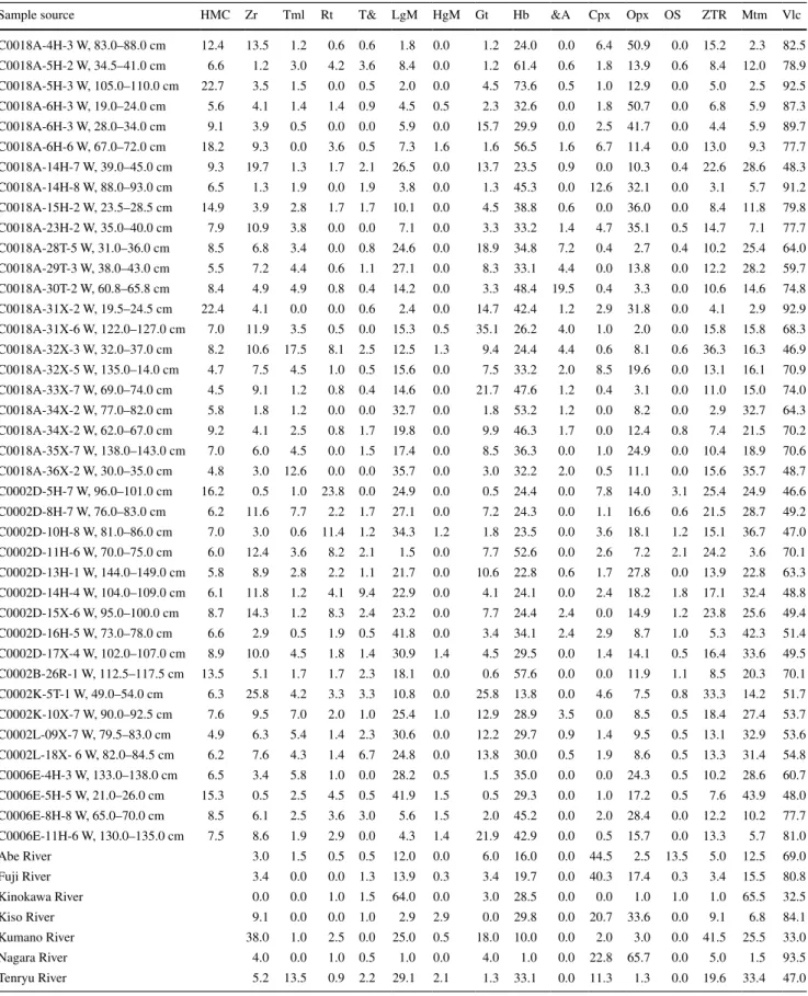
I and lower unit II, respectively. The zircon and rutile grains are mostly at the initial to slight stage of corrosion, while the tourmaline grains are largely unweathered (Fig. 3; andò et al. 2012). In general, the average ZTR index for the vari-ous sites is rather low, which presumably reflects inherent deficiency of the sources of the sands in zircon, tourmaline and rutile. The low values exclude repeated recycling of these ultrastable minerals from older sediments and there-fore represent a primary provenance signal.
Titanium minerals and others (T&)
This indicates the total percentage composition of titanium minerals (including sphene, anatase and brookite) and other
transparent minerals (such as apatite) that cannot be clas-sified into a specific group. The T& is, overall, very low and identical in all sites and units with C0002, C0018 and C0006 having an average of 3, 1 and 1 %, respectively, with no discernable trends. The apatite grains are either unweathered or at the initial stage of corrosion (Fig. 3; andò et al. 2012).
Low‑grade metamorphic minerals (LgM)
This expresses the percentage composition of heavy min-eral suites of the epidote group (including epidote, clinozo-isite, zoisite and piemontite) and chloritoid, among the total heavy mineral assemblage. This classification is a first-order
C0006E-4H-3W, 133-138 cm C0006E-11H-6W, 130-135 cm C0018A-33X-7W, 69-74 cm C0018A-30T-2W, 60.8-65.8 cm C0018A-36X-2W,30-35cm m c 1 4 -5 . 4 3 , W 2 -H 5 1 -A 8 1 0 0 C C0002B-26R-1W, 112.5-117.5 cm C0002D-10H-8W, 81-86 cm C0002D-14H-24W, 104-109 cm
approximation as epidote (included here in the lgM) may persist well into medium-grade metamorphism (e.g. Winkler 1976). also, high-pressure/low-temperature metamorphic minerals of the glaucophane–riebeckite series (including the blue to lavender-blue sodic amphibole), which have a great diagnostic importance in provenance (e.g. Mange-Rajetzky and Oberhaensli 1982), are included in the lgM as their sep-aration into a distinct group will require distinction that can-not be done under the microscope and a rather arbitrary split of other amphibole categories (Garzanti and andò 2007a). at Site C0002, there is a gradual and subtle change in the lgM concentration from bottom to top. In contrast, there is
a drastic change in the lgM composition in the slope basin from an average of 19 % in Unit Ib to less than 8 % in Unit Ia. a noteworthy observation is the remarkable similarity in the heavy mineral suites of Unit II and Unit Ib of Sites C0002 and C0018, respectively. The trench wedge is com-parable to both Unit II and Unit Ib of the forearc and slope basin, respectively, with an average of 20 % lgM composi-tion. The grains of the epidote group minerals (including epi-dote, zoisite and clinozoisite) are at the initial to slight stage of corrosion, while the chloritoid grains are unweathered. The sodic amphiboles are mostly unweathered to etched and slightly corroded (Fig. 3; andò et al. 2012).
Unit
I
Unit II
Hemipelagic mud Zircon
Volcanic ash Silt turbidites
Turbiditic sands T& Rutile Tourmaline LgM HgM Gt Hb &A Opx Cpx OS
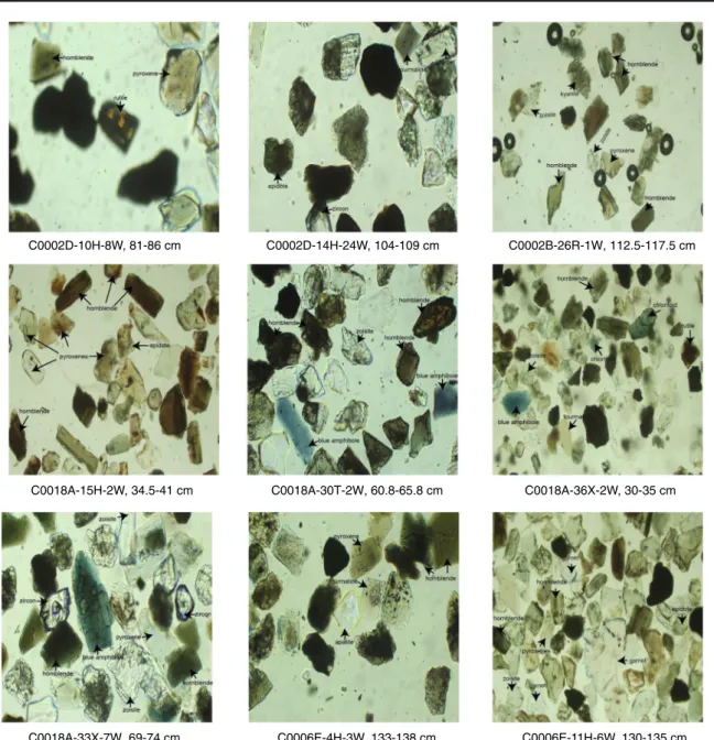
Depth Units Lithology (C0002) Heavy minerals abundances
100 90 80 70 60 50 40 30 20 10 0 % 500 400 300 200 100 0 Unit I mbsf Unit II (HMC) (16.2) (6.2) (7.0) (6.0) (5.8) (6.1) (8.7) (6.6) (8.9) (13.5) (6.3) (7.6) (4.9) (6.2)
Fig. 4 Heavy mineral distribution and concentration in the sand
layers at Site C0002. abbreviations used in figure and legend are as follow: HMC heavy mineral concentration; T& titanium and oth-ers; LgM low-grade metamorphic minerals, HgM high-grade
meta-morphic minerals, Gt garnet; Hb hornblende (green + brown); &A other amphiboles; Cpx clinopyroxene; Opx orthopyroxene; OS oli-vine + spinel (after Garzanti and andò 2007a)
High‑grade metamorphic minerals (HgM)
This represents the combined percentage of heavy mineral species chiefly derived from high-grade amphibolite facies metaigneous and metasedimentary rocks. This includes minerals such as staurolite, andalusite, kyanite and silli-manite. The HgM is generally very low in all sites and units ranging from 0.2 % in C0002 Unit I and C0018 Unit Ib to 1.5 % in Site C0006. Staurolite grains are slightly corroded and etched while kyanite grains are mostly at the initial stage of corrosion (Fig. 3; andò et al. 2012).
Garnet (Gt)
This represents the combined percentage of garnet present in the analysed sample. Garnet is usually found in metamorphic rocks but can be present in plutonic and ultramafic igneous rocks. It is usually found in metapelites and metabasites, and
it is commonly derived from contact metamorphism of impure limestone, metasomatic skarns and schists that were produced by regional metamorphism of limestone (Mange and Maurer 1992). Garnet is one of the most ubiquitous mineral species as it is found in all of the samples investigated albeit to a varying degree in sites and units. at Site C0002, the average is 6 % and 11 % for Units I and II, respectively. at Site C0018 Unit Ia, the composition ranges from 1 to 15 % averaging 5 %, and 2–35 % in Unit Ib with an average of 12 %. The trench sedi-ment ranges from 2 % in Unit I to 8 % in Unit II. The garnet grains are mostly unweathered with few grains at the initial stage of corrosion (Fig. 3; andò et al. 2012).
Hornblende (Hb)
This indicates the overall percentage of the widely abun-dant calcic amphibole (including the green and brown vari-ety of hornblende) among the total heavy mineral species.
Fig. 5 Heavy mineral
distribu-tion and concentradistribu-tion in the sand layers at Site C0018. For
symbols, see legend in Fig. 4
300 10 20 30 40 50 60 70 80 90 100 0 100 0 200 % Unit Ia Unit Ib Unit Ia Unit Ib
Depth Units Lithology (C0018) Heavy minerals abundances
(12.4) (4.8) (6.6) (22.7) (5.6) (9.1) (18.2) (9.3) (6.5) (14.9) (7.9) (8.5) (5.5) (8.4) (22.4) (7.0) (8.2) (4.7) (4.5) (5.8) (9.2) (7.0) (HMC)
Hornblende is unarguably the most common mineral in all investigated samples. at C0002 and C0006, the average composition of hornblende reduces from bottom to top of the lithostratigraphic column. On the other hand, the horn-blende composition increases from bottom to top at C0018 from 37 to 42 %. The lowest hornblende composition is observed in Unit I of C0002 with an average of 27 %. The degree of corrosion in the hornblende grains ranges from unweathered to slight, whereas the weathering stage ranges from unweathered to corroded (Fig. 3; andò et al. 2012).
Other amphiboles (&A)
This represents the combined percentage composition of all other amphiboles (including tremolite and actinolite)
among the heavy mineral species. Generally, the composi-tion of &a is negligible, <4 %, in all sites and units. &a is totally absent in the trench-wedge deposits. &a ranges from 0.5 in both Unit I and Unit Ia to 4 % in Unit II and Unit Ib of C0002 and C0018, respectively. The few tremo-lite grains observed are unweathered.
Clinopyroxene (Cpx)
This is the combined percentage composition of augite and diopside among the heavy mineral species in the analysed specimen. In general, all the sites and units are deficient in clinopyroxene with <4 % in all samples. There is an overall subtle increase in the clinopyroxene content from bottom to top in all sites. The augite and diopside grains are mostly at
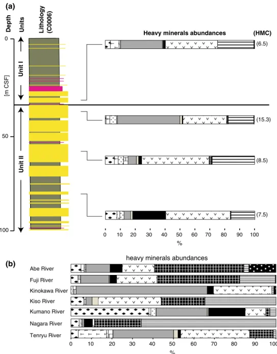
Fig. 6 Heavy mineral
distribu-tion and concentradistribu-tion in the sand layers at Site C0006 (a) and reference river sands (b). For symbols, see legend in Fig. 4 Unit II [m CSF] 50 0 100 100 90 80 70 60 50 40 30 20 10 0 % Tenryu River Nagara River Kumano River Kiso River Kinokawa River Fuji River Abe River
heavy minerals abundances
100 90 80 70 60 50 40 30 20 10 0 %
Depth Units Lithology (C0006)
Unit
I
(a)
(b)
Heavy minerals abundances (HMC)
(6.5)
(15.3)
(8.5)
the initial stage of corrosion and are slightly etched (Fig. 3; andò et al. 2012).
Orthopyroxene (Opx)
This represents the combined percentage of hypersthene and enstatite in the heavy mineral suite. In contrast to the clino-pyroxene, the orthopyroxenes are widely distributed and relatively abundant in most of the analysed samples. Hyper-sthene accounts for most of the orthopyroxene (>94 %) as few grains of enstatite are present in a few number of the analysed samples. The general observed trend is an increase from bottom to top of the stratigraphic column in all sites. Compared with the other two sites, C0002 has very low orthopyroxene content ranging from 10 to 16 %. Unit Ia of C0018 contains the highest proportion of orthopyroxene with an average of 30 %. Most of the observed orthopyrox-ene (mostly hypersthorthopyrox-ene) are unweathered or at the initial stage of corrosion (Fig. 3; andò et al. 2012).
Olivine and spinel (OS)
This expresses the total percentage of olivine and spinel present in the samples. The olivine and spinel composi-tion in all the units and sites is negligible having as low as 0.4–1.5 % in all samples. There is no discernable system-atic trend in compositional variations in olivine and spinel in all the sites and units. The few grains of spinel observed are slightly corroded
Reference rivers
The river samples also have characteristic heavy mineral modal proportions (Table 1; Figs. 6, 7). Samples of the Fuji, abe, Kiso and nagara Rivers bear significant amount of pyroxenes. The pyroxene minerals in Kiso and nagara are mostly euhedral in shape, suggestive of tephra origin. abe River comprises spinel as a dominant component, which is absent in other river samples with the exception of the Kinokawa River, where a few grains were found. The Kinokawa River runs in the central Kii Peninsula to the west along the Median Tectonic line and has more tributar-ies in its southern side, where the Sanbagawa metamorphic belt (including the Mikabu Greenstones) and the Shimanto accretionary complex are located (Fig. 1). The Kumano River sample shows high abundance in zircon, and some-times garnet is common. The Tenryu River has the great-est diversity in heavy mineral composition among analysed river samples. It contains pyroxene, hornblende, epidote group minerals and tourmaline in moderate ratio as well as a variety of other minor components such as zircon, garnet, allanite and actinolite.
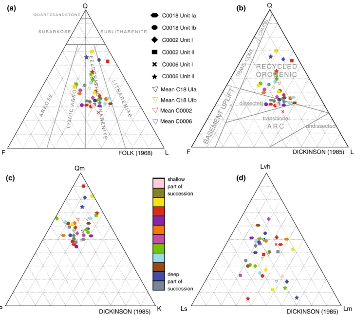
Modal framework grain composition
The sand samples recovered from the forearc basin, slope basin and trench wedge are divided into three major petro-facies as defined by Folk (1968). These petropetro-facies are as follows: feldspathic litharenites (C0002, C0006 and
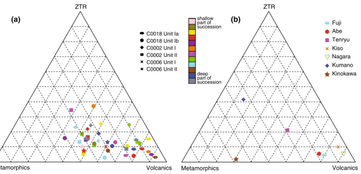
Metamorphics Volcanics Fuji Abe Tenryu Kiso Nagara Kumano Kinokawa shallow part of succession deep part of succession C0018 Unit Ia C0018 Unit Ib C0002 Unit I C0002 Unit II C0006 Unit I C0006 Unit II Metamorphics Volcanics ZTR ZTR (a) (b)
Fig. 7 Ternary plot of the modal proportion of heavy minerals in
cores (a) and river sand samples (b). notes on figure: the colour
bar indicates the depths in the stratigraphic section from top (shal-low) to bottom (deep). For example, a yellow hexagon is shallower
than a blue hexagon, although they belong to the same Unit Ia of Site C0018, and a brown diamond is deeper than a red diamond, despite that they belong to the same Unit I of Site C0002
C0018), lithic arkose (C0002 and C0018) and litharenite (C0002) (Fig. 8a).
The sands from the Pliocene forearc basin facies sam-pled at the Kumano Basin Site C0002 are medium-grained to coarse-grained and subrounded to subangular. Sample depths at the site range from 42.39 to 704.625 mbsf. The most characteristic constituents of this deposit are quartz and volcanic lithic fragments. On the Q-F-l plot, the mean field for Site C0002 Unit II lies close the quartz-lithic cor-ner (Fig. 8b). The mean modal values are Q-46 %, F-20 %, l-34 % (the % will subsequently be omitted), and lvh-40, ls-25, lm-35, but there is a significant scatter about the
mean (Fig. 8b–d). The average Qm–P–K modes are Qm-65, P-19, K-16 (Fig. 8c). The detrital modes are consid-erably similar to the C0018 Unit Ib modes, and the most evident distinction is in their monocrystalline components. The monocrystalline quartz in C0002 goes as high as 65 %, while the plagioclase and K-feldspar contents are consider-ably similar to those of C0018 Unit II.
Samples from very fine-grained sand layers in the upper, Middle to late Quaternary stratigraphic interval (Unit Ia) at the slope basin Site C0018 are from depths ranging from 29.48 to 189.185 mbsf. The sands are dominated by vol-caniclastic materials probably derived from the Honshu
DICKINSON (1985) Lvh DICKINSON (1985) Qm shallow part of succession deep part of succession Q CR ATO N F L undissected RECYCLED OROGENIC A R C dissected transitional BASEMEN T UPLIFT TRAN S. C ONT. DICKINSON (1985) AR KO SE Q S U B A R K O S E S U B L I T H A R E N I T E Q U A R T Z S A N D S T O N E Ls Lm P K F L LIT HIC A RK OS E O T LIT H SE TH RK F E L D S P A T H IC L IT H A R E N IT E L P T R T E A R C S P F A R E P A T FOLK (1968) L IT H A R E N IT E A N E N T H A R E N IT E C0018 Unit Ia C0018 Unit Ib C0002 Unit I C0002 Unit II C0006 Unit I C0006 Unit II Mean C0006 Mean C0002 Mean C18 UIb Mean C18 UIa (b) (a) (d) (c)
Fig. 8 Detrital modal plots for the nankai Forearc sands. a, b Q–F–
l, c Qm–P–K, d lvh–ls–lm. Q = Total quartz (monocrystalline quartz and polycrystalline quartz), Qm quartz monocrystalline, P Pla-gioclase, K K-feldspar, F Feldspar (P + K), L lithic fragment, Lt total
lithics, Lvh volcanic lithics, Ls sedimentary lithics and Lm metamor-phic lithics. Notes: see Fig. 7 for colour scheme. The triangle symbols indicate the mean modes of each site as appropriate
and Shikoku arcs. Their modes plot near the l section on a quartz–feldspar–lithic (Q–F–l) diagram with a mean of Q-34, F-26, l-40, and close to the lvh corner on the vol-canic–sedimentary–metamorphic lithic (lvh–ls–lm) plot with a mean lvh–ls–lm of lvh-53, ls-22 and lm-25 (Fig. 8b–d). Feldspar is the most abundant monocrystalline component, and K-feldspar dominates. The mean Qm–P–K modes are Qm-36, P-30, K-34 (Fig. 8c). The volcanic frag-ments are characterized by feldspar and quartz phenocrysts with minor devitrification textures. Within the layers, there are numerous fine-grained sedimentary and metamorphic lithic fragments, although in some of the grains, distinction between chert and sedimentary lithic fragment is difficult. Few grains of volcanic glass were also identified.
The lower stratigraphic section (Unit Ib) of C0018 is characterized by medium-to-coarse-grained sands belong-ing to the Early Pleistocene slope basin facies. In compari-son with Unit Ia, it is extremely rich in sandy intervals and sample depths range from 233.185 to 305.22 mbsf. The grains are dominantly angular to subangular and contain abundant quartz and volcanic rock fragments. Plagioclase is the dominant feldspar type. The mean modal values for the 12 samples recovered from this unit are Q-38, F-28, l-34, and lvh-38, ls-30, lm-32. The average Qm–P–K modes are Qm-56, P-26, K-18 (Fig. 8b–d). a large num-ber of the monocrystalline quartz grains display undulose extinction with incipient polygonal shape with no visible deformation band. This suggests a low-grade metamorphic source rock for the sand. Many of the fine-grained rock fragments are volcanic glass and/or fine-grained mudstone and minor quantities of phyllosilicate grains.
Site C0006, drilled near the seaward edge of the accre-tionary prism, provides a great constraint on the trench-wedge sedimentation. Here, only four samples were inves-tigated for modal analysis. The total quartz content for the sands is as high as 50 %, while the remainder is made up of lithic fragments. Metamorphic lithic fragments account for over 50 % of the total lithic fragments with 30 and 20 % of sedimentary and volcanic lithic fragments, respec-tively (Fig. 8b). Sample depths range from 28.365 to 70.204 mbsf. The mean modal values are Q-50, F-21, l-29 (Fig. 8b), and lvh-20, ls-29, lm-51 (Fig. 8d). Some of the monocrystalline quartz grains are similar to those from C0018 Unit Ib in that the grains show undulose extinction, developed polygonal shapes and rare deformation bands. Few grains of fine-grained quartz and lithic sandstone are also present.
Discussion
There are fundamental spatial and temporal variations in the bulk composition of the Kumano Basin, slope basin
and trench-wedge sediments of the nankai Trough. In the western portion of the nankai accretionary wedge, trench-slope basin sediments on the lower trench-slope were derived from Cretaceous–Tertiary Shimanto metamorphic and neogene– Quaternary volcanic rock exposed along the southwestern margin of the Japan Island arc (Marsaglia et al. 1992). Several rivers along the southeastern margins of Shikoku, Kyushu and Honshu crosscut the Shimanto complex and drain into several submarine canyons and forearc basin along the nankai Trough (Fig. 1). at present, only a few of these submarine canyons are directly linked to the nankai Trough (e.g. Suruga Canyon; De Rosa et al. 1986). Taira and niitsuma (1986) found a close correlation between the Suruga Trough and Fuji River and concluded that the Suruga Trough is fed by the Fuji River. Quaternary sands from the lower sandy unit in Site C0018 suggest a mixed provenance: recycled orogen and dissected magmatic arc (Fig. 8). This implies that the Cretaceous–Tertiary Shim-anto Belt may have been the major source of sands in Unit Ib at C0018. Shimanto Belt sedimentary sequences, which have been deformed by strike-slip faulting, folding and compression, vary from unmetamorphosed to weakly meta-morphosed rocks (Taira et al. 1982). Therefore, subaerial/ submarine erosion of fine-grained units within the Shim-anto Belt could have produced the sedimentary and meta-morphic lithics found in the Mid-Quaternary turbidite suc-cession of the offshore slope basin (Fig. 8b). However, the relatively high percentage of volcanic lithics in the upper late Quaternary Unit Ia sands (Fig. 8b) suggests additional volcanic sources to the trench-slope basin after ~1 Ma. The dominantly microcrystalline volcanic lithics assemblage in Unit Ia could have been derived from volcanic centres in the Fuji region of central Honshu. The Q–F–l modes plot on Dickinson’s (1985) recycled orogen and dissected arc field, and this bimodal provenance may be characteristic of marginal basins formed by rifting of continental-margin arc systems (Marsaglia et al. 1992).
There are also clear and systematic differences in heavy mineral composition by sites and lithologic units. Both forearc and slope basin sands from the upper units (I and Ia, respectively) are differentiated from the deeper units (II and Ib at Sites C0002 and C0018, respectively) by increased abundances of pyroxenes and the green and brown varieties of hornblende. This distinction is most evident in the slope basin facies where the volcanic minerals—pyroxene and green/brown hornblende—increase from half of the heavy mineral component in Unit Ib to over 75 % of total heavy mineral species in Unit Ia. This transition is more subtle in the forearc basin facies, with a modest 4 % increase from 45 % in Unit II to 49 % in Unit I. The observed changes in heavy mineral composition could result from changes in provenance of the detrital grains, hydraulic sorting effect and selective dissolution of unstable heavy minerals
resulting from surficial weathering in the basin and/or during burial diagenesis. The surficial textures of all ana-lysed grains range from unweathered to slightly corroded (Fig. 3), showing that dissolution of unstable heavy min-erals is a minor and relatively negligible factor for such a drastic and significant change in heavy mineral composi-tion. also, pore-water geochemical analysis of dissolved species at Sites C0006 and C0018, which may indicate alteration of mineral species, shows little or no alteration (Expedition 316 Scientists 2009a; Expedition 333 Scien-tists 2012; Expedition 338 ScienScien-tists 2013). at site C0002, there is some evidence from pore-water geochemistry for clay mineral reactions and cycling of iron/manganese in the deepest part (Expedition 314 Scientists 2009; Expe-dition 315 Scientists 2009); however, this is deeper than our sampling depth at this site. The ZTR index, which is a measure of the degree of reworking and hydraulic sort-ing, is quite low (Table 1; Fig. 7) to be a significant con-trol on the observed change in composition. Furthermore, our average HMC values range from 7 to 9, similar to the values obtained by Garzanti and andò (2007b) for subduc-tion orogens, indicating no significant loss due to diage-netic dissolution or sharp enrichments caused by hydraulic sorting effects. Therefore, we attributed the changes across the 1 Ma boundary to a change in provenance and that the heavy mineral concentration and composition are mainly controlled by the source rock.
The volcanic minerals of the trench-wedge samples from Site C0006 account for about 60 % of the total heavy min-erals. In contrast, Unit II of the forearc and Unit Ib of the slope basin are richer in metamorphic mineral species such as the epidote group, garnet, kyanite and sillimanite, which decrease and increase at Sites C0002 and C0018, respec-tively, from bottom to top until the 1 Ma boundary. across this boundary into the younger section, the trends suddenly reverse at both sites (Fig. 9a). However, the clearest signal of compositional changes comes from the preponderance of blue sodic amphibole of the glaucophane–riebeckite series, indicative of erosion of high-pressure/temperature-type metamorphic source rocks: in Unit II of the forearc basin and Unit Ib of the slope basin, blue amphiboles are frequent but nearly lacking in the related overlying units. Glaucophane was not observed in any of the river sam-ples. The occurrence of glaucophane in the present geo-logic context within the outer zone of the Japanese Islands is limited to the high-grade blueschist/greenschist parts of the Shimanto and Sanbagawa Belts in central Shikoku (e.g. aoki et al. 2008) except for Yaeyama Islands near Tai-wan (Yossii 1935), which are too far to be source regions. Takeuchi (1988) reported the occurrence of some grains of glaucophane from sandstones in the central Kii peninsula in the catchment of one of the Kinokawa River. Mouri and Enami (1988) also recorded grains of amphibole, whose
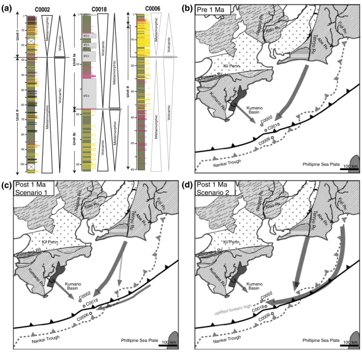
composition is close to glaucophane from the Sanbagawa Belt close to Tenryu River but not within its catchment. Tenryu River has the greatest petrological similarity to the samples of forearc basin Unit II and slope basin Unit Ib except for the lack of blue sodic amphibole. The high-grade metamorphic heavy mineral composition favours the Kumano/Kinokawa and, to a lesser extent, the Tenryu Riv-ers for the source of sediment for Unit I of the forearc basin and Fuji/abe Rivers for the source of sediment for Unit Ia of the slope basin. These mineralogical observations sug-gest that the sands in the lower part of Unit I of the forearc basin are probably from the Tenryu and Kumano/Kinokawa Rivers but progressively dominated by the Kumano River until the upper part of the unit is overwhelmingly domi-nated by Kumano River component (Fig. 4). Similarly, after 1 Ma in the upper slope basin section (i.e. Unit Ia at Site C0018), the sands are mostly dominated by the Fuji and abe River components (Fig. 6). These data and inferred provenance can be explained by two alternative scenarios (Fig. 9b–d):
{Scenario 1} Constant flux from the Tenryu River to the two units over time; however, with a significantly increased influx of vol-canic mineral species to the lower slope since ca. 1 Ma, likely to be derived from the Izu-Honshu collision zone along the trench axis. The sediment flux is now being dominated by Fuji and abe Riv-ers and presumably was dominantly routed via the Suruga submarine can-yon since ca. 1 Ma (Fig. 9c). This sce-nario would be in line with interpreta-tions derived previously by Fergusson (2003) from sands recovered from Sites 1175 and 1176 in the trench slope along the Muroto Transect off Shikoku Island more to the southwest of our study area. It also suggested that apparent contradic-tions of the data set presented by Clift et al. (2013), which has not detected any input from the Izu-Honshu collision zone even more to the southwest of our and Fergusson’s (2003) study area, may have indeed simply resulted from spatial and temporal sampling resolution. Fergus-son (2003) concluded that the sands in the trench slope were transported from the north–northwest down the inner slope rather than by axial transport along the nankai Trough, and the mafic to inter-mediate volcanics are consistent with derivation from the east of the Izu-Bonin
and Honshu Island arc. Overall, uplift of Tertiary and older subduction com-plexes in southwest Japan occurred at approximately 15 Ma on the Kii Penin-sula (Hasebe et al. 1993; Tagami et al. 1995). at ca. 6–16 Ma, emergent south-west Japan was dominated by Cretaceous and younger plutonic and volcanic rock
of the inner zone, which would imply a transverse delivery of sediment from the northwest. The last phase of the four accretion events at 1 Ma is responsi-ble for the influx of sediments along the nankai Trough (Fergusson 2003). a con-stant sediment influx of the Tenryu River, however, may not be fully supported by Post 1 Ma Scenario 2 600 100 0 200 300 400 500 MTD 1 MTD 2 MTD 3 MTD 4 MTD 5 MTD 6 100 0 200 300 Unit Ia Unit Ib Metamor phic Metamor phic Vo lcanic Vo lcanic C0018 600 100 0 200 300 400 500 800 700 1000 900
(c)
Phillipine Sea Plate
Nankai Trough Kii Penn. Kumano Rv . Kinokawa Rv . Te nryu Rv . Kiso Rv. Nagara Rv . Abe Rv . Fuji Rv . Pre 1 Ma Kumano Basin C0002 C0018 C0006 100 km
Phillipine Sea Plate
Nankai Trough Kii Penn. Kumano Rv . Kinokawa Rv. Te nryu Rv . Kiso Rv. Nagara Rv. Abe Rv . Fuji Rv . Post 1 Ma Scenario 1 Kumano Basin 100 km C0002 C0018 C0006
(a)
(d)
Phillipine Sea Plate
Nankai Trough Kii Penn. Kumano Rv . Kinokawa Rv. Te nryu Rv . Kiso Rv. Nagara Rv . Abe Rv . Fuji Rv . Kumano Basin 100 km C0002 C0018 C0006 uplifted forearc high C0002 Unit II Metamor phic Vo lcanic Vo lcanic Metamor phic C0006
(b)
Unit I Unit II Metamor phic Metamor phic Vo lcanic Vo lcanic Unit IFig. 9 Heavy mineral compositional trends at the three IODP
sites (a), and the tectonic evolution model of the offshore Kii Pen-insula showing the sediment dispersal patterns prior to 1 Ma (b), and after 1 Ma for two scenarios: scenario 1, without the influence of the forearc basin uplift (c), and scenario 2, as a result of Kumano
Basin edge uplift (d) on sediment routing. Positions of the subduction front through time are indicated as solid black and grey dashed lines for situations at around 1 Ma and today, respectively. For legend of onland geologic patterns, see legend in Fig. 1
present-day routing system of the Ten-ryu canyon that dissects the accretion-ary prism and enters the nankai Trough further to the northeast of the studied Kumano Transect (Fig. 1). If correct, however, this scenario would therefore imply that the dissection of the Tenryu canyon occurred in geologically very recent time and that prior to the dissec-tion, sediment routing from the Tenryu River was not into the trench but along the upper slope into the forearc and slope basin. Since samples from the lower prism Sites C0006 and C0007 do not record the trench-wedge sedimentation after accretion 0.436 Ma (Screaton et al. 2009), this scenario cannot be conclu-sively tested.
{Scenario 2} The similar composition of sands with a distinct metamorphic mineral assem-blages within the Kumano Basin and lower slope basin deposits prior to ca. 1 Ma, and the distinct differences between the two sites after ca. 1 Ma can result from forearc high uplift, thereby limiting the flux of sediment by Kumano/Kinokawa Rivers into the slope basin. Sediment underthrusting, which began at ca. 1.3 Ma and continued until after 1 Ma, resulted in the entire uplift of the Kumano Basin edge overlying the thick zone of underthrust sediment (Bangs et al. 2009). Gulick et al. (2010) showed that after some local shorten-ing (beneath the southwest part of the Kumano Basin and seaward of the outer arc high) in the Early Quaternary, regional tilting of the Kumano Forearc basin occurred in the Middle to late Quaternary, resulting in the landward shifting of depocenters during uplift and then basin infilling subsequent to uplift. The implication of this on sedi-ment dispersal would be a confinesedi-ment of sediments derived from onland south-west Japan into the Kumano Forearc basin, which were hitherto bypassing the forearc and transported transversely all the way to the slope basin and trench wedge (Fig. 9d).
a decrease of flux from the Kumano side as implied by the “forearc high blocking the sediment routing” scenario 2
is more likely and also consistent with the decrease in sedi-mentation rate from ca. 2.5 cm/year in Unit Ib to ca. 1 cm/ year in Unit Ia at the slope basin site C0018. also, episodic mass transport due to submarine landslide recorded by MTDs in the slope basin Unit Ia at Site C0018 (Strasser et al. 2011, 2012) is consistent with the forearc high uplift scenario, where mass wasting occurred more frequently after 1 Ma due to slope instability of the steeper upper prism slope along the uplifted forearc high.
These interpretations, however, are based on conceptual mixing models for sand from different river systems. Sand populations within each river is complex, and the assump-tion that modern river systems are a good analogue for the ancient river systems may not completely hold for systems more than a million years back in time. nevertheless, the presented scenarios are in good agreement with what has been proposed for the tectonic and lithostratigraphic evolu-tion of the nankai accreevolu-tionary prism and thus considered to reflect the first-order relation between changing sedi-ment routing systems and tectonics of the nankai Forearc.
Conclusions
The petrographic sandstone data from the forearc basin, slope basin and trench-wedge sediments of the nankai Trough accretionary wedge show systematic variations in bulk and heavy mineral composition in both space and time. The generic tectonic provenance for these sands is: a recycled orogen blended with dissected magmatic arc terranes.
There is clear evidence for both long-distance axial transport on the trench floor and direct transverse influx of sediment from the island arc feeding turbiditic sands to the slope basin studied at Site C0018. The Izu-Honshu colli-sion zone serves as the principal detrital source region for the volcanic-rich sediments of younger (<1 Ma) Unit Ia. Most of the sediments were probably derived from within the Fuji River drainage basin and funnelled through the Suruga submarine canyon to the trench environment. an overwhelming quantity of sediments in the deeper Unit Ib could have been derived from the Tenryu River drain-age basin and submarine canyon system, which is located immediately west of the collision zone.
Two end-member hypotheses are proposed for explaining the observed abrupt facies, detrital modes and heavy min-eral suite changes from Unit Ib to Unit Ia in the slope basin. Using end-member turbidite sand samples from the forearc basin and the trench wedge to constrain the sedimentation in the forearc and trench wedge, these two alternate hypotheses, when combined, clearly indicate a decoupling of sediment routing via long-distance axial transport and transverse flux of sediments around 1 Ma. This is most likely influenced by