Publisher’s version / Version de l'éditeur:
Vous avez des questions? Nous pouvons vous aider. Pour communiquer directement avec un auteur, consultez la première page de la revue dans laquelle son article a été publié afin de trouver ses coordonnées. Si vous n’arrivez pas à les repérer, communiquez avec nous à [email protected].
Questions? Contact the NRC Publications Archive team at
[email protected]. If you wish to email the authors directly, please see the first page of the publication for their contact information.
https://publications-cnrc.canada.ca/fra/droits
L’accès à ce site Web et l’utilisation de son contenu sont assujettis aux conditions présentées dans le site LISEZ CES CONDITIONS ATTENTIVEMENT AVANT D’UTILISER CE SITE WEB.
Technical Memorandum (National Research Council of Canada. Division of
Building Research); no. DBR-TM-24, 1952-11-01
READ THESE TERMS AND CONDITIONS CAREFULLY BEFORE USING THIS WEBSITE. https://nrc-publications.canada.ca/eng/copyright
NRC Publications Archive Record / Notice des Archives des publications du CNRC :
https://nrc-publications.canada.ca/eng/view/object/?id=ca12deed-edeb-4ceb-bb7d-95e2b8ac0fd2
https://publications-cnrc.canada.ca/fra/voir/objet/?id=ca12deed-edeb-4ceb-bb7d-95e2b8ac0fd2
NRC Publications Archive
Archives des publications du CNRC
Access and use of this website and the material on it are subject to the Terms and Conditions set forth at
Suggested classification of Muskeg for the engineer
The Associate Committee on Soil and Snow Mechanics is one of about
thirty
special committees which assist the NationalResearch.Council in its work. Formed in 1945 to deal with an urgent wartime problem involving soil and snow, the Committee is now performing its intended task of co-ordinating Canadian research studies concerned with the physical and mechanical propertiesof the terrain of the Dominion. It does this through sub committees on Snow
and Ice, Soil Mechanics, Muskeg, and Permafrost. The Conunittee, which con-sists of about fifteen Canadians appointed as individuals and not as represent-atives, each for a 3-year term, has funds available to it for making research grants
for workin its fields of interest. Inquiries will be welcomed and should be
addressed to: The Secretary, Associate Committee on Soil and Snow Mechanics, c/o The Division of Building Research, National Research Council, Ottawa, Canada.
Suggested Classification of
Muskeg
for
the
Engineer
by
Norman W. Radforth
McMaster University, and
Royal Botanical Gardens, Hamilton, Onto
A paper presented before the 66th Annual General and Professional Meeting of The Engineering Institute of Canada, at Vancouver, May 1952.
Foreword
The Expression "Muskeg"
The Associate Committee on Soil and Snow Mechanics of the National Research Council has been concerned, since the start of its work, with studies of the terrain of Canada ..Muskeg constitutes a large propor-tion of the total area of the country, although situated in the less accessible areas, its signi-ficance is not always appreciated by the city dwellers.
As the boundaries of national develop-ment steadily advance, the problems which muskeg can create when it is traversed, or when it interferes with ..ngineering work, arc becoming increasingly important. The Associate Committee is therefore pleased to be able to publish this first major report on a project which it has supported financially, and in which it has long been interested.
After an early investigation of the chaotic use of even the word "muskeg" in Canada, the Committee was glad to find in Dr. Rad-forth a scientist whose special field of interest was palaeobotany, through which discipline an approach to the scientific study of organic terrain alone seemed possible.
'Working closely with the Defenr-e Research Board, which is primarily interested in the interpretation of muskeg conditions from the
The interpretation of mineral soil aggregates has become a
well-estab-lished study, and is now being
approached from many directions in the scientific and engineering realms. Some branches of the field are relatively new. Their develop-ment is just beginning to broaden. The consideration of mechanical problems relating to mineral soils, for instance, is comparatively young. By comparison with this, however, knowledge concerning the interpre-tation of organic soils is negligible. No organized reference system for organic soils is in existence. Until it is, the utilization, treatment and
adjustment of organic soils for
engineering purposes will remain a difficulty.
Under these circumstances, the
air, the Committee has supported Dr.
Radforth in field work at Churchill, Mani-toba, in visits to European muskeg areas, and in his laboratory investigations at Hamilton, Ontario, at McMaster University, and the Royal Botanical Gardens.
Dr. Radforth has accumulated a vast amount of information, many samples of muskeg and an unusual library of photo-graphs of organic terrain. Tsing this, and his wide field experience, he has managed to develop a rational system of classification for a rna teria I long regarded as "unclassi-fiable".
The suggested classification is admittedly a first approach only to a singularly difficult problem. Its imperfections will be shown only by its use. Its improvement and further development will come only after such field application. The Associate Committee and Dr. Radforth will therefore welcome com-ments and criticisms and, in particular, reports upon the use of the suggested classi-fication in the field.
R. .F.LEG GET
Chairman, Associate Committee on Soil and Snow Mechanics. National Research Council.
comparison of results in problems of foundation engineering wherever an organic soil is involved will al-ways be troublesome and at best,
inadequate. This is particularly
true when the soil medium in ques-tion is almost completely organic: the material called "muskeg".
Possibly because of its biological
The writer has gone to consider-able lengths to determine what is intended by the word "muskeg" by those who use the term. The results of the inquiry have been enlighten-ing hut bewilderenlighten-ing. The range of meaning ascribed to muskeg is so broad that the word has question-able value when used as a precise
origm, muskeg is an extremely complex material. In degree of
com-plexity, it compares favourably
wilh that of an v mineral soil and its
variabilitv is likewise well marked. IVlorcovc;, in assessing this material
for engineering purposes, dcpth,
form and other features that refer to the soil bodv as a whole, are just as significant for the organic as for the mineral soil.
Finallv, in applying engineering techniques and interpretations, at-tendant factors such as water and physiographical phenomena are just as important for organic soils as for mineral soils as agents influeucing
soil character. .
In the present study the writer has had in mind the need for ade-quate portrayal of muskeg features. It is thought, however, that this objective is secondary in import-ance to the development and presen-tation of a svstem whercbv
intelli-gent イ・ヲ・イ・ョセ・ can be QセQ。、・ to
muskeg.
While it is true that this primary objective relates more to the need of the engineer interested in problems of trafficabilitv, construction and foundation engineering, it is hoped that the information will be of use to foresters, geographers, biologists,
pedologists, conservationists, and
indeed to all those associated in one way or another with muskcg.
reference term. Some would include swamp under the heading of "mus-keg". Others would differ and claim that it signifies the shore of a
bog-lake. It has been used as
synony-mous with tundra. It has been
employed to designate imponded
areas completely covered with vege-tation, or the thickly carpeted Boor
Reprinted Irom THE ENGINEERING JOURNAL, November 1952
Organic Terrain Deposits
The author, Dr. Radford. (right) with H. F. Legget, M.KI.C., chairman of
the arrn uul rHecting session at whieh the paper was presented.
of open spruce woodland, and in many instances has been supplied as an acceptable reference term to signify "peat-bed".
\Vhen used in an v of these wa vs, no special size Iir;lit is specified.
Frequently it is applied in
des-cribing large areas of land more 01'
less coutiuuous for several thousands of square miles. This is especially so in the case of the Canadian :\orth and Northwest. On the other hand, it may be utilized as referring to small patches of overburden, par-ticularlv in the eastern. western and souther:n parts of Canada and in some parts of the l.'uited States.
The flexibility and vagueness of
meaning that "muskeg" implies
leads to confusion, and provides
serious difficulty when practical
and intelligent use of the expression is at.tcmpted for purposes of dis-cussion and report. This situation is further aggravated when the expres-sion is used to label the field material itself. Becaus« of this diflicultv it is tempting to eliminate "muskeg"
as a reference t--rm altogelhN. To
discard it completely, however,
would invite other problems. Though the term is attended by such lack of agreement, it has, none the less, come into frequent use and doubtless will continue to be used.
Also, though its meaning is not
clear, those' who have become accus-torned to using it in connection with
their work, regard it with some
respect. They are content to as-cribe to it their own particular set of values, no matter how this might be at variance with the views of others.
Literally interpreted, "muskeg" suggests simply "peat-bog"
(Chip-pewan Indian. maskeg, meaning
"grassy bog"). Though this defini-tion is not adequate as it stands, it does furnish a fundamental meaning which can be widely appreciated, and which shows promise of accept-able expansion. Primarily, the idea of organic constit ution is inferred. There is also in the literal defini-tion the suggesdefini-tion that a high
per-centage of water influences the
character of the organic medium.
The kind of organic deposit in-eluded in the expression "organic terrain" has widespread distribution. In contemplating the limitation of
"organic terrai n" as a reference
expression, the writer feels that
geographic implications are
import-ant.
Organic terrain deposits occurring in Europe, Asia and Xnrth America all merit study. In Canada organic terrain predominates in areas hav-ing horizons separated by as much as a thousand miles. Such countrv rnav be found in the Yukon, iii Saskatchewan, and Manitoba. Smal-ler areas, but still significantly large, occur in British Columbia, Ontario,
Quebec, New Brunswick, Nova
Scotia and Newfoundland.
Organic terrain also occurs in
Washington, Oregon, North Dakota, Michigan, New York and the New England States. To a lesser degree
A. third idea which may be in-herent in the literal tran;lation is spatial delimitation. This possibi-lity coincides with the suggestion of some, that the term "bog" includes the saturated organic matter held in a more or less saucer-shaped depres-sion, frequently two or three miles in diameter. This view does not support the impression that muskeg may be an extended sheet of organic material, with a depth generally uniform over great distances, in excess of say, twenty miles.
A workable definition of "muskeg" might thus be simply "organic ter-rain". The possible weakness may, however, be dismissed if it is agreed that the expression relates not only to materials, but also to states or conditions. Certainly, if any trans-lation of "muskeg" is to exclude
this proposal it will have to be
regarded as inadequate at the out-set.
The expression "organic terrain" seems to allow for the inclusion of the base of the organic matter and the top of the underlying mineral soil in considerations relating to "muskeg". It also allows any refer-ence to topographic conditions and
ground surface characteristics in
general, The designation does not preclude the use of the expression "organic deposit". It does suggest, and in a sense specifies the nature of the deposit. Some organic deposits such as coal, lignite, oil and sub-merged peat beds would be excluded by the expression.
it occurs in other regions within the
Lnited States. Perhaps the best
known geographic regions in which organic terrain occurs are in the British Isles and in northern Europe. The largest continental areas con-taining -deposits comparable with those of Canada are in Siberia.
The great bulk of the deposit, wherever located, arises as an
ac-cumulation of vegetable matter.
The thickness of the material varies
considerablv.Itmav be one to a few
inches in depth, or it may be between one and two hundred feet in depth. Whatever the depth, it is still
sig-nificant as a potential problem,OJ' as
a predominant element providing
character or limitation for large
areas. For any given expanse of this kind of overburden the depth is more often than not variable. Con-stancy in depth is, however, a con-dition not uncommon, particularly in the far North.
Survey of Conditions for Classification Organization, The Basis for Classification Any system of classification
pre-supposes the existence of organiza-tion in whatever medium is to be classified. The higher the degree of orderliness in the medium under study, the better will be the chances
for recognizing organization, and
the more the promise of rendering a classification that will justify the widest acceptance. 'Whatever the form of classification, if it is to be successful, its procurement depends upon the manifestation of organiza-tion.
It is also important to realize that the procedure of revealing organiza-tion may depend on reference to
natural relationships within the
medium being classified, or on the other hand to artificial relationships arbitrarily revealed. It must also be expected that if the material to be classified is highly complex, the classification system ultimately
de-Having set out the terms of reference for the basis of classifica-tion, it now remains to explore the material and conditions which con-front the field observer. This explora-tion involves two realms: that which
embraces the hidden or
under-ground aspects, and that which
involves surface features lying in full view.
Subsurface Constitution
In any sort. of construction prob-lem involving "muskeg", the field observer generally feels that the materials he is dealing with fall into the category of black, unstable muck. This is inadequate if the engineer desires as clear and com-plete a picture of organic soils as he insists upon for soils derived from a mineral source. It. is therefore neces-sary that the constitution of organic terrain from the aspect of particle size, form and distribution should be studied and incorporated into the main framework of classification.
This will serve to parallel the increasingly important. information existing with regard to the parti-culate constitution of mineral soils. In the latter field, not only is particle size an important factor for the
engineer, but kinds of particles,
their frequency of occurrence and their distribution, are also import-ant. The relationship between one kind of particle and another in the physical, chemical and mechanical sense is also significant. It. is not surprising, therefore, that thc same point of view should he accepted
rived may be also complex. It may include not one, but several, sets of classification systems. In cases of this kind, one system may parallel another, or one system may be subsidiarv to another.
It キッセャ、 be unfortunate if, in
establishing the basis for classifica-tion for a medium that has so far evaded interpretation, an attempt were not made to distinguish be-tween identification and classifica-tion. In this account, classification will be used to segregate and define
properties of materials and condi-tions. Identification will be used in referring to examples of materials and conditions. Thus, examples will be regarded as identifiable through classifiable properties. Thus, it seems proper to emphasize that the recog-nition of classifiable properties with-in the organic terrawith-in is the funda-mental task.
and utilized with reference to an interpretation of organic terrain.
Size and Disposition01Constituent Particles
Interpretation of organic terrain depends upon reference to particles or units of two orders of size; one microscopic, the other observable with t.he naked eye (macroscopic) in the field. The attention of the reader is first directed t.o the latter.
On the assumption that the field engineer makes adequate
prelimin-ary investigation of the organic
terrain materials, he will readily appreciate that dead plant remains, appearing as visible units of the
terrain, differ widely as to size,
quantity and spatial relationships. At one place in the organic blanket. he is traversing, he may encounter "black muck" which, when dry, does not fall away but. remains in "chunks" or "cakes". These have a fine granular texture, with larger units in negligible abundance.
Instead of this condition he mav come across one in which the sam pie consists of non-woody (soft, resist-ant) fibres, short and int.erlacing to form a mesh. Or he mav have select-ed instead a sample in which the fibres (again non-woody and quite numerous) are long, pel'haps up to a foot in length, contrasting with an inch or two for the previous sample.
These may be ribbon-like and
oriented more or less in a vertical plane.
Or he may discover an example consisting mostly of woody, inter-lacing and thread-like fibres, forming
3
a mat which offers considerable
mechanical strength. These threads may be only a few inches in length, but could be several feet. long and follow a tortuous course, conforming to no particular plane. The survey may reveal the possibility of the presence of examples in which the fibres arc recognizable as tree roots or branch systems, which make it difficult. to procure samples.
In some instances, this woody mesh may be made up of short "chunks", in others of extended "pole-like" units of different lengths. It is not the purpose of this article to discuss isolated mechanical pro-perties or sets thereof which t.hese
various examples might furnish. 1t
does, however, seem desirable to emphasize the structural contrast. that. exist.s between say, t.he first and last mentioned examples. Mechani-cal problems relative to these would
also show obviouscontrast,
Much could be written about variation in quantity of given par-ticle types occurring within a unit volume of terrain. Shape, as well as size and content of the units, would
figure prominently. Suffice it t.o
state here thatquanlitivc range with
respect. to frequency of given particle type must include levels near 0 per cent, as well as levels close to 100 per cent.
It is well to remember that before t.he observer there is a range of possible unit sizes which includes both particles of granular size just. visible to the naked eve, and units
which may be the セゥコ・ of fence
posts or even larger. Regardless of orientation it is a natural assump-tion that some sort of three-dimen-sional mesh, net or web, will inevit-ably be present in the organic ter-rain. The interstices of the mesh may be very small or may be quit.e large, depending upon the size of the units making up the mesh.
Particularlv where the interstices are large, it 'is not difficult to con-ceive that. a mesh of a second order of size mav exist in the interstices of the first order. Where the
inter-stices are extremely small their
contents are made up of particles
microscopic in size, along with
various organic derivatives which together form a material essentially colloidal in nature.
Cohesion and compact ability of examples will obviously show up
differently, depending upon the
nature of the mesh, the size of the particles and the constitution of the interstices. Disint.egration and ten-dency to flow or shift. or shear, or to resist compressional forces, arc other features that will vary with
the physical characteristics of the materials expressed, and depending, too, on their orientation.
Spatial relationships suggest a consideration of the vertical dimen-sion or depth of the organic terrain. The question may arise for instance, as to whether there is a change in range of particle size throughout the depth. This is frequently the
case, and the situation may be
readily revealed by exposing aprofilc through the organic blanket. It is important to recognize that this change is, in most cases an orderly one, conducive not only to inspec-tion for quality, but also to measure-ment.
Where there is change in range of particle size and size of mesh there is noticeable change in the banding or layering that exists in the peaty material. The handing conforms or
corresponds with the structural
change, making structural correla-tions and comparisons possible in a given profile or volume of terrain. There are frequent examples, of
course, in which the particulate
constitution of the organic material is the same for all practical purposes throughout the depth of a section. Finallv, reference should be made to the h"orizontal dimensions which implies coverage over area. 'Vhere the peaty material is uniform in texture throughout its depth, ex-amples are known of its covering areas four or five miles in extent. The deposit as a whole may have a
shape which relates to
physic-graphical characteristics of the area in question.
Shapes of deposits more often than not conform to recognizable
features or conditions prevalent
either in the landscape, or through the nature of the organic material under observation. 'Where the con-struction of the material is not the same throughout its depth, but is noticeablv handed as revealed in profile, the frequency of change in peat construction over an area is comparatively high.
It can now be seen that reference to organic terrain on the basis of particle size and distribution cannot be considered adequate if use of expressions such as "black muck" are insisted upon. Intelligent ap-praisal of conditions existing in organic terrain will never be possible, as long as it is thought only neces-sary to refer to peaty material as
constituted of leaves, twigs and
other plant remains.
Water Content and Drainage
There must be acknowledgement of the presence of water either in
liquid or solid form in relation to a survey of conditions for classifica-tion. The peaty material in the
organic terrain forms a natural
reservoir for water, and conditions are known where drainage is almost impossible. Regardless of particle size, shape and arrangement, the constitution of peat is such that it can retain large volumes of water. It can be shown that like volumes of peaty material differing in physical
make-up will drain at different
rates, will recharge at different
rates and will have different potenti-alities for maximum water retention. Structure and amount of organic terrain are also related to natural drainage channels, some of which are obvious to the eye because they exist as river-like systems; others of which are not so 'obvious, in that they travel within the peat or at the peat-mineral interface, and can only be recognized through impending.
Before drainage in relation to organic terrain can be adequately assessed, seasonal climatic data have to be related to local ficld and organic terrain conditions. Enough has been surveved to establish the claim that water content is not merelv related to organic terrain. It enters into its constitution, and must be regarded as a part of "muskeg", along with the peaty material. Thus, water (liquid or solid) enters into the definition of organic terrain, and definitions are fundamental to classification.
Organic-inorganic Interface
In consideration of mineral soils, it often occurs that the engineer must direct his attention to regions within a soil body, where a soil identified as having one set of pro-perties is related physically to a soil identified as having another set of
properties. This region of in
ler-relationship is often more important than either of the two parent bodies concerned in the relationship.
Sometimes the zone of contact is very narrow and mainly in one plane. Sometimes there are faults in it, and other structural deformities. Occa-sionally it may be a zone of some
depth-a kind of transition bed
which may vary in thickness
throughout the zone. In Lhe case of each of the parent bodies referred to,
it must be recognized that the
attrihutes of each include a con-sideration of the fact that the one
soil body has the other as its
neighbour.
A similar situation arises with reference to the peaty layer of the organic deposit and the mineral soil
sub-layer in contact with it. The
4
zone of contact is often quite thin and sharply marked. On the other hand, the writer has worked with
an interface material which was
mineral maller highly charged with organic material nearly a foot in depth, forming an interbed which varied in thickness and in structural composition.
It is not alwavs the case, as is commonly supposed, that the min-eral substrate is fine textured, falling into the category of silts and clays. On the contrary, organic overburden often lies directly upon a coarse grained substrate of a sandy, some-times gravelly constitution. Indeed, it is not infrequent to find that the peaty layer may be in contact with coarse gravels containing quite large boulders. If the organic layer is only a foot or two in depth, the contour of the boulders or rocky outcrops is imparted to the peaty overburden, and becomes a
topo-graphic feature of the organic
terrain.
Examinatioll of the zone of inter-face often reveals wide differences as to relative amounts of water. Sometimes the interface is almost completely fluid. On the other hand, it may he just moist. "'aler by reason of its presence and abun-dance is an important component of the interface zone.
Interface problems lllay be just as great as those involved within the organic layer itself. This is not to suggest, however, that in specific
problems, as for instance with
highway subsidence involving fail-ure of foundation materials, it is necessarily the interface that must be held responsible. Where a whole roadbed slides to one side, possibly the worst kind of failure found in "muskeg" country, studies suggest that failure is more often a function of structural relationships within the organic layers, which have not been accounted for in surveys that preceded construction.
Emphasis, so far, has been placed on sub-surface constitution. Com-position of organic material, water relations and organic-inorganic inter-face have each been referred to separately. The ultimate system of classification mav reveal a
relation-ship linking エィセ three subtopics.
Even at this stage of "muskeg"
interpretation, prediction of the
constitution of the mineral sub-layer is not ruled out once the con-stitution and extent of the organic layer has been determined.
Surface (overage
For foundation, drainage,
proh-lems, those concerned usually give
first consideration to the soil bodv,
With mineral soils, examination セヲ
exposures and interpretations from borings are always useful. The same
should apply with organic soils.
Profile exposures arc none too
frequent in this case, however, and while horings are always possible, the presence of other field marks can prove useful. In the lattereonnec-tion, an observer traversing organic terrain is tempted to make use of the upper level of the organic layer. This comprises the aerial and sub-aerial parts of all the living plants
affording coverage for the dead
organic material in the rest of the organic overburden.
The Living Organic Layer
For purposes of this survey of
conditions for classification, the
most important mailer is to empha-size that the living organic material is an essential part of the organic terrain. It is certainlv included in the literal translation' of "muskeg" referred to earlier. Hccognition of this means a corresponding exton-sion of the list of properties which ha ve to be used to describe organic terrain.
The field investigator has the
responsibility of recording ficld con-ditions, as he experiences them in
studying organic terrain. He is
always alert to the possibility of finding plant types which he may use as valid indicators for various purposes. More oftcn than not, he attempts to find the common name for any plant which he may select. The writer is quite certain that this idea was not initiated by botanists, but by field workers of other profcs-sions, trades and vocations.
In an attcmpt to confirm the validity of this procedure and its degree of usefulness, the writer, par-ticularlv in his work in the Churchill area, n{adc a fairly complete collec-tion of plants typical of the organic terrain of those regions ..Most of the striking, colourful typcs of plants have, however, proved troublesome when used as indicators. Perhaps this is partly because certain plant types of the nature referred to are not faithful as indicators for given
terrain conditions. .
This, however, docs not eliminate plants of the living organic layer as
analyticalindices, Independent field
investigators and observers have
developed habits of referring to
particular kinds of vegetative
cover-age. Though non-botanists, they
apparently had little difficulty in establishing common denominators on which they could compare their
experiences, by reference to vegeta-tion properties for which they pro-video their own descriptive terms.
In discussions bearing on these
matters such terms as trees, shrubs grasses and mosses would be used.
Such reference methods are not
new to engineering surveyors, as
shown hyoid survey records. With crude reference terms where precise designations arc required, the ad-vice of a trained field botanist is always of value. These preliminary attempts at coverage recognition provide encouragement for the bota-nist (field ecologist).
The Topographic Factor
In its broadest meaning, topo-graphy suggests description of form
outline of land areas. Phvsical
features, relating to unevenness of contour, take a prominent position in terrain consideration. In practice, location of drainage basins is also important, but in organic terrain
appraisals, expediency rules that
attention be given to terrain uneven-ness. "'here water bodies are con-cerned, the nature and stability of the organic foundation lining thc
water course must be observed,
both beneath the water and at the banks. 'Vhatever the point of view
of the field surveyor responsible
for the interpretation of field con-ditions, he is bound to concern himself with over-all form and form trends, if any, as he attempts to traverse organic terrain.
It has been suggested that topo-graphic difference in organic over-burden is sometimes due to irregu-larities in the mineral foundation of the organic blanket. On the other hand, much of thc unevenness seen from the surface is due to topo-graphic change within the organic material itself. In studies of mineral soils it is not always easy to demon-strate the reason for topographic change. The same difficulty arises for the organic soils. In the north, frost phenomena are prevalent, and these are the controlling agents in contour establishment and regula-tion. Other agents are water and wind. There is evidence that these
fac-tors sometimes act together to
produce some of the shapes of the organic terrain. Perhaps the most influential agent, however, is one that is a function of the vegeta-tion (dead and living) which forms
the organic overburden, This is
recognized partly through change in character of the peaty material, and partly through growth habits of certain plants as they augment and accumulate organic debris at their growth sites.
5
Even if contour phenomena were eliminated as necessities in "mus-keg" interpretation, field appraisers and those whose task it is to deal with "muskeg" would be among the
first to insist that methods be
devised to account for them, to
assist in classification and in intelli-gent appraisal. Coverage and topo-graphy arc important also in aerial
interpretation of organic terrain.
But whether the observer is in the air or on the ground, eovemge and
topography are the conspicuous
factors of the organic blanket on which he is primarily dependent.
The Seasonal Aspect
An appraisal of the conditions for classification of organic terrain is not complete without reference to the time factor, as this associates itself through seasonal aspects. In most parts of Canada, "muskeg" is completely frozen throughout the winter. Possible exceptions to this may arise due to the lower depths of very deep deposits being protected from frost for at least a part of the winter by the insulating values of the upper layers of the deposit.
With t he approach of high
tem-perature conditions in t he far north in later spring and early summer, melting of the active ice commences on and within the organic mass. Due chiefly to drainage lag, for which the peaty materials are partly
responsible, the accumulation of
water is verv marked. This is
notablv true セカィ・ョ rainfall in the
early summer is high. If, on the
other hand, rainfall is not excessive, and if winds are frequent and strong, excess water and the growth of ponds may not be too noticeable, as compared with average conditions. The wasting of the acti ve frost layer during the summer months is
a slow process. This applies, of
course, chiefly in the far north as for exampic, around Churchill and to-wards Le Pas in the south. The condition has its effect on the ap-pearance of the coverage, imparting to it seasonal aspects which are characteristic for cach time period during summer and early autumn months. The seasonal aspect will vary depending upon coverage and
other properties of the organic
deposit. Mechanical properties of the various kinds of peaty materials will also show relationship to this seasonal factor.
In field inspection, it is difficult to resolve the seasonal factor into something tangible which can be
evaluated in . terms other than
qualitative. Some assistance is, how-ever, afforded through the medium
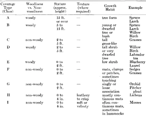
Table I-Summar)' of Properties Designating Nine Pure Coverage Classes
cipally stature, degree of woodiness, external texture and certain growth habits easily recognized by an inexperienced observer, especially with the help of photographs. l<:xamples of plant material arc given following each colour-type description.
Commenting briefly on method of application, it is important to note in the first place that, when an observer records an appropriate class designation by letter, that letter by reason of its relationships in the table signifies the properties suggested. Seldom do these pro-perties defining the coverage exist alone. They occur rather in com-bination wlth properties for which other class letters are svmbolic. In olher words, one ウ・ャ、ッョセ finds pure classes exist.ing by themselves.
For given areas requiring analysis, practice' seems to decree that, if one set of coverage class properties is not present to the extent of twenty-five per cent, it lacks enough prestige to give it significant promi-nence in the composite cover des-cription. The complete description rna,Y sometimes, therefore, be given, though not often, in terms of one, two or three let tel's.
The reader might expect an over-whelming number of combinations of classes. For selected areas in the Churchill region and far to the south, however, this is not the case. For instance, the descriptions involving the use of the letters F - E - I are quite frequent. In the formula, or combinations of letters,
Stature Texture Growth
(approx. (where
Habit Example
height) required)
セ M M M
15 ft. tree form Spruce
or over Larch 5 to young or Spruce 15 ft. dwarfed Larch tree or Willow bush Birch 2 to tall Grasses 5 ft. grass-like
セ to tall shrub Willow
5ft. or very Birch
dwarfed Labrador
tree tea
() to low shrub Blueberry
2 ft. Laurel
() to mats, dumps Sedges
:l ft. or patches, Grasses sometimes touching () to singly or Orchid 2 ft. loose Pitcher association plant
() to leatherv mostly con- Lichens
4 in. to crisp tinuous mats
() to soft or often con- Mosses
4 in. velvety tinuous mats,
sometimes in hummocks \Yoodiness vs, Non-woodiness woody non-woody non-woody non-woody non-woody woody non-woody woody woody G C D H I E F B Coverage Type (Class) -A
such that thev can be readilv understood セョ、 utilized by non-botanists; and
(5) Types of coverage that the terms express must be graphed, and authentic photo-graphs must be available for wide use.
As may well be expected, meeting the challenge of this grouping called for much checking and rechecking from the air and from the ground, both in field observation and in la boratorv analvsis of results. An added complication arose through the need for anticipating Lrallic-ability problems and mechanical problems in general, sometimes re-lating to industrial, sometimes to engineering and sometimes to agri-cultural, geological, forestry or mili-tary requirements.
The accompanying table (Table
I) presents the descriptive informa-tion for nine coverage class types. Photographs depicting these' types appear in Figs. 8-16. An examination of the schedule given in the table will show that the properties men-tioned are not referable to species of plants. They relate instead to quali-ties of vegetation, These are prin-segments of the coverage, as well as in background coverage. This is done with the aid of the Munsell Colour System.
*
'Munsell Book of Color: Pocket Edition,
Munsell Color Co. Inc., 1929-1942.
The Classification System
Onlv those features of cover-agemost likely to show direct relationship with features of the dead organic material comprising the bulk of the "muskeg" deposit, will be utilized.
The expressions used in clas-sification will be those bcst suited to the recognition of organization 111 the coverage; The expressions and the level of organization ultimately de-picted will be such Lhat they can be used also for aerial inspection and interpretation. Travel over "muskeg" is pre-dorninantlv by air.
The term; employed will be
(4)
(1)
(2)
(3)
It is now possible, against the foregoing background, to suggest the main lines of the classification system so far developed to meet the need for accurate identification of muskeg. 'l'his is a first presentation only, given in summary form on the basis of work extending throughout fivc field seasons and winter labora-tory working periods.
Coverage Pattern and Typing
Classification depends upon the possibility of revealing organization and relationship. IfIhis can be dono,
It major first step will have' been
accomplished. The only ot her funda-mental prerequisite to classification is to plan for a level of adequacy appropriate to the degrl'c of com-plexity of the mat cria]s and condi-tions being classifie d. For organic terrain, with its high dl'gree of complexity, sen-ral snhsidiary sys-tcms are required,
One of these S\'S!c'IIlS should be
based on coverage. For the purposes of this account, priority should be given to it, in that it is the first factor of the terrain which the observer notices when he encoun-ters a "muskeg" expanse. If cover-age classification is to be in terms of a subsidiarv svst.etu, it would be of little ョ、オセ if its relationship to another subsidiary system dealing with another main factor of the terrain were not anticipated.
In segregating coverage charac-ter, therefore, the plan has been devised in accordance with the following
rules:-of colour. With LIH' advance of season there arc local and general background colour changes in the coverage. Though the task is not easy, it is possible to measure and record colour response in superficial
DE P T H FROM SJQFACE DEPTH FROM surfac⦅セ ,-T c .IBuBヲセ '.J ,., ( ) II rs , . j I II I I I iセ
-
-
セ
I'F
I LLセ•
•
II•
1 1 1 --
-
ill セI
'-I I Ir
"•
, vi•
セZA
zセヲ I ::> vIII•
::> I x W W."". セ..
セ•
f-a , セiャ⦅-
-
セii-,-
•
I.
セ I 11II u"'
1,1 w c ac ,0 " sc ';0Iセ。 F .. EG ...E·,C'{ .- ,. ,.
IMIZOCEt::TJ-i FhCt.t\ sLMセfZGce DEPTH FROM SURFACE
.'U"15 a.セ セ.セ ,., oI''"' r s "j ,-. 10-" i i I I
i
I . . . . セ-
-
IZLセ
..
-
-iiセ..
•
•
I iIIII-
-1Il.
•
i•
•
Aiャセ..
..
-セN I I I "...
l-I-
,-t-V'......
-
•
IセZLイ
•
I,
Z|Qセ セ•
セ,
i
z> クᄋGセ I ::> 1-
I-",.
•
セ..
", I »c---
•
I-Wf:'. セiャ⦅-
-
0 I I セ il. II.
I•
I.
セ
•
セ II: I I I II
III" II 11111 I I "A II
0"
iC..
"
,"'" lo!> FREOuE',(f" "
"
..
Ill(! IliJ FREOUE NCYTop left to lowerイゥセィエZ Fig. 1, Fig. 2, Fig.
a,
Fig. 1.that letter which represents the
most prominent set of properties is
placed first. If other letters are
involved, they follow in the formula in order of prominence.
Thus, the formula gives a des-cription of coverage composition in terms of properties and lays em-phasis on the set of values most typical for the area. It is instructive to select at random areas of, say, ten square miles in extent and to analyse them by application of the methods suggested. Within a given area so selected, the frequency and degree of influence that each set of
class properties shows is easily
derived from the sets of formulae obtained. The formula having great-est frequency will also be revealed. Finally, if the formulae are map-ped, directional trends arc exhibited. If several areas are compared with reference to properties, the dcgree of importance with reference to these factors can be derived, and the pattern exhibiting coverage
proper-ties becomes manifest. In short,
coverage organization is revealed. Referring again to the guiding principles, there is good reason to suggest that points 2 to 5 have been satisfied. The aspect of aerial inter-pretation is being tested on the basis of the method prescribed here,
and evidence has been suggested to show that it can be applied
satis-factorily. Improvements and
ad-justments of a secondary nature will doubtless be forthcoming, but fundamentally, main requirements are mel. Discussion concerning the
application of the method and
system in relation to rule (1) will
be left to follow the discussion of the next subsidiary system.
Indexing for Subsurface Character
Turning now to the dead organic material in the organic terrain, a
different approach is needed to
derive a workable classification
svs-tern. In making the survey of the materials available to which classi-fication is to be prescribed, reference has been made so far to macroscopic
features only. Attention of the
reader has been called to informa-tion suggesting the presence of a mesh structure and related inter-stices. There is some evidence sug-gesting that differentiation of peat
samples might be accomplished
through an understanding of mesh size, construction and prevalence.
This alone is not enough, because during the formation of the organic body the mesh characters might
well remain relatively constant,
particularly with the larger sizes of 7
mesh, while characters of the peaty material might change. The nature of a secondary mesh, for instance, could easily change in constitution without noticeable change in the structural relationships of the pri-mary mesh, The material in the interstices might also change with time, in amounts sufficient to alter the physical properties of the peaty deposit as a whole.
Consequently, if some method of classification could be devised to give a record of the succession of vegetation, built into the deposit as a whole in the course of time, this would provide a more certain basis. It would also permit a better under-standing of the macroscopic ingre-dients from the point of view of both classification of properties and
the appreciation of mechanical
problems.
To accomplish this task, it is necessary to look to a study of
microscopic constituents. As the
components of past vegetation
matured and contributed their
re-mains to peat formation, their
presence was recorded by the num-erous pollen grains, which are nor-mally preserved as they fall into the peat. 'tany of these are doubtless carried some distance before they
Top left to right: Fig. 5, Fig. 6. Lower: Fig. 7.
inch in size, removed at intervals from different levels of each core.
Usually every second inch was
examined. The microfossils were
released from the rest of the peaty matrix with the use of chemical
re-agents (ten per cent potassium
hydroxide is most frequently used by palaeobotanists for this purpose). Following washing and centrifuging, a few drops of the sediment were transferred to microscope slides for permanent record.
It was from each of these sets of preparations that microfossil iden-tifications and counts were made. For this, the usual practice adopted by palaeobotanists is to count two hundred microfossils with the aid of a microscope fitted with a mcchani-cal stage, then determine from this the proportion of each kind or category of microfossil. Sometimes the total number counted may be less than two hundred where statis-tical comparisons seem to warrant it. This was the method adopted for the investigations reported here.
When it was reasonablv certain
that enough samples h'ad been
analysed to reveal a complete range of microfossil types, attention was centred on variation in frequency for each kind of microfossil, at different depths in the peat and in many locations over a wide area.
The fundamental aim was to
utilize the microfossils as identifi-able reference units, which would point to state, organization, and change, if any, for all manner of peaty profiles and examples which showed even slight structural dif-ferences. For the non-botanist, rec-ognition need only be given to the fact that in the process of analysis these microfossils are related to the plants from which they are derived.
Ifthis is appreciated,
it
is then onlynecessary to call each microfossil category an index unit and to give it a number. The strictly botanical aspects can be dealt with elsewhere. One more brief point requires explanation before the inspection of results should be made. This has reference to microfossil frequency. Not only is the actual presence of particular microfossils significant; numbers at given levels in the peaty deposit provide data equally, if not more significant, in evaluating
re-sults. It must be emphasized also
that wherever numbers of index units are mentioned, relative
num-bers are inferred.
Attention may now be directed to
Fig. 1. Each of the three sections of
the diagram records the occurrence and relative frequency of the micro-scopic index units for three depth
FREOUENCY
DEPTH FROM SURFACE
-0.) HHHH 1-1. o£:-I
•
Nセ I -I..
that derived from tree pollens, and in the north there are vast areas which arc treeless. For the present work the kind of microfossil which would carry most influence would
be thatキィゥセィ has been produced by
plants growing on the site under examination. The question arose whether there were enough of these relicts throughout the peaty deposit
to provide material that would
stand statistical analysis. It took two summers to convince the writer that this was a reasonable possi-bility, and detailed analyses were then pursued on a broad and in-tensive scale.
This approach for recent organic deposits is entirely new, particularly when it is associated with the idea of revealing properties for classifica-tion purposes. It is not new,
how-ever, applied to coal structure,
stratigraphy, and utilization prob-lems. The difficulty of readapting techniques of analysis and providing new ones caused some complica-tions. Planning and carrying out the field work on a sufficiently broad scale was time-consuming.
The materials studied for micro-fossils were obtained from the field, either as cylindrical cores taken with a peat borer (Hiller Model), or as channel samples from an exposed peat profile. The ultimate analyses were made from portions one cubic
•
....
FREOUENCY
DEPTH FROM SURFACE
-.1.·1 • . , i
L
-,
-
•
...
1 Lセ I•
-
•
•
..
-
".
I•
-
-
ml•
•
/Iセ•
I.-
•
•
•
セ i v,.•
•
I =0 III.•
セBLLZM I-
•
セiャB•
•
1,.
•
•
VI.•
I'V' XI'Iassumption that large numbers, if not the majority, fall in the area where they are produced and pro-vide a continuous record of the vegetation.
Should it occur that, during this
recording, climatic conditions at
intervals are such that the surface of the deposit is dessicated, preserva-tion would be interrupted and the continuity of the record broken. This, however, is not a serious matter if these fragments (micro-fossils) are to be used to symbolize that vegetation which had been preserved, and whose record had not been destroyed by climatological conditions. It is only the existing portion of the deposit that is before the observer for interpretation. It is to these microfossils that the writer turned for help in classifica-tion problems relative to sub-surface conditions.
In the initial part of the investi-gations there was much hesitancy concerning this approach. This was partly because much of the field work was being carried out in the north, sometimes at latitudes fur-ther north than Fort Churchill, Manitoba.
Most of the work done in connec-tion with microfossils has, however, been related to forest history and the study of past climates. For this the chief kind of microfossil utilized is
'"
.-c lO セセ Nセ エセ 10{1';';:
Nセ -c'-c·REOUENCY
DEPTH FROM SURFACE
-) -S"
,-
,,'
I.
LLセ ,..
,,'
>-'.
zv:1 :J 1i ;., _ x : セャGセセ セ[ャ II I.' Ir, セ..
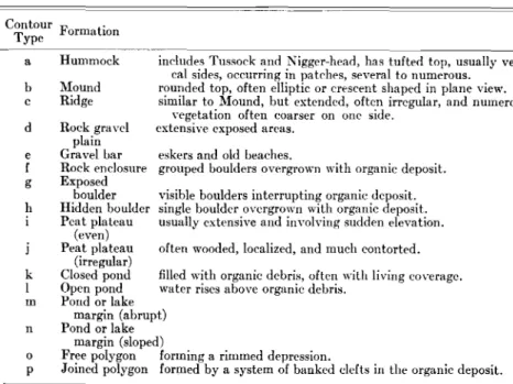
Z V I _ =0 II,. :;V.... セヲG⦅ II 1I1 "'I 8Table II-Terminology and Properties for Topographic Classification
Descriptive Terminology for Topographic Features
Contour F .
Type ormation
In the section dealing with the relationships and importance of the topographic factor to problems of surface coverage classification, an account of the precise terms of
classification for topography was
omitted, for inclusion under this main chapter on classification. As was the case in selecting type cate-gories for vegetation coverage, and
pies from the Churchill area. Hun-dreds of such samples have now
been taken, and many of them
examined for index unit relation-ships. Samples are also available from northern Sweden, the Orkney and Shetland Islands, as well as
from several places in Canada.
When enough histogram patterns are available for wide comparison, relative prevelanee of pattern, and hence relative prevalence for organ-ization trends, may well be dis-eernable.
In the meantime a workable and
adaptable system for identifying
peats is now available. That it is workable has been demonstrated. That it is adaptable has been only partly demonstrated. In connection with the latter, the question arises,
how can the svstern be utilized in
demonstrating' organization from
the standpoint of structural features, significant from the aspect of
me-chanical problems? The answer
depends ill part on a consideration
of other subsidiary systems of
classification, two of which have not yet been reviewed. One of these which deals with topography will be presented next.
in selecting type index units for subsurface appraisal, so with topog-raphy type expressions are
neces-sary. Itis important in making the
selection that they prescribe to all contour phenomena, that they
con-form if possible to expressions
already in use, and that they be as few in number as circumstances permit.
often wooded, localized, and much contorted. filled with organic debris, often with living coverage. water rises above organic debris.
visible boulders interrupting organic deposit. single boulder overgrown with organic deposit. usually extensive and involving sudden elevation.
includes Tussock and Nigger-head, has tufted top, usually verti-cal sides, occurring in patches, several to numerous.
rounded top, often elliptic or crescent shaped in plane view. similar to Mound, but extended, often irregular, and numerous;
vegetation often coarser on one side. extensive exposed areas.
Rock gravcl plain
Gravel bar eskers and old beaches.
Rock enclosure grouped boulders overgrown with organic deposit.
Exposed boulder Hidden boulder Peat plateau (even) Peat plateau (irregular) Closed pond Open pond Pond or lake margin (abrupt) Pond or lake margin (sloped)
Free polygon forming a rimmed depression.
Joined polygon formed by a system of banked clefts in the organic deposit.
-Hummock Mound Ridge o p n k I m e f g h b c a d
organization, it affords classifiable
data, and it refers directly and
indirectlv to constitutional features
utilized セウ factors in the
interpreta-tion of peaty materials in the mus-keg. Deliberate attempts have been made to avoid the use of botanical
expressions, in order that field
reference may be made in terms understandable to all.
There is yet a third general
orga-nization feature discernible. For
this, reference should be made to Figs. 5, 6, and 7. A comparison of these histogram sets
shows;-(1) Dissimilarity of histogram
pattern for each set;
(2) Each set differs in pattern from the others;
(3) Organization still reflected in spite of variation as suggested in points 1 and 2;
(4) Constitutional trends (not
stability) which have arisen with growth in depth of the peaty deposit; and
(5) Each item (1 to 4) can be
assessed on a quantitative
measureable basis.
The data used in these graphs are derived from only seven bore sam-intervals within a core sample. The
core was analysed according to the method described earlier.
There should be no difficulty in understanding the terminology ex-pressed at the co-ordinates of the graph in the figure. Each configura-tion in successive histograms desig-nates both presence and frequency for an index unit. Because these configurations differ as to length, collectively they provide a histo-gram pattern useful in classifying the condition with respect to the microfossil features for the appro-priate depth. For the three sets of histograms indicated, observe there is close similarity in appearance and
therefore in classification value.
Examination of the detail within each histogram reveals important
information. It is of primary
impor-tance to recognize the more general feature, namelv that which
demon-strates relationship in histogram
pattern.
Similarity, in the form of faithful
repetition セオァァ・ウエウ stability in the
constitution of the peaty deposit throughout its depth. This is in addition to the more fundamental fact that these methods provide the means for a practical comparison -one which is confirmable and
which lends itself to quantitive
measurement.
It is encouraging to the investi-gator, and to all those who desire to interpret organic terrain conditions, to discover that these first data assist in establishing confidence in the matter of classification of the dead organic material, not only in principle, but also at the level of practical necessity.
Referring now to Figs. セL 3 and 4,
similarity in histogram pattern will
also be observed. It is true that
there are slight differences. These are of a secondary nature, however, and can be rationalized when mat-ters of detail are under considera-tion. This lends support to the view that the analvtical methods have validity, and 'that a reliable basis for classification is established.
The next significant feature of the results is that for a given set of histograms, the set of patterns is peculiar to that example. For ins-tance, a comparison of Figs. 1 to 4 shows that marked contrast exists among the four examples, in spite of the high degree of similarity in each. Thus peats, stable in constitu-tion throughout their depth, may differ in constitution one from the other. This then is another major and encouraging demonstrable fact
revealed through application of
these methods. It is further proof of
INTERPRETIVE DATA (LABORATORY)
Slide Nos. 1040, 1046, 11:27.
Analysis Sheet. . No. 14.
Intervals Examined 0-1" 1_2" :2_3"
Index Units . : : : hゥウエセァイ。セ pattern deposited in laboratory Royal Botanical
(Occurrence & Frequency) Gardens, Hamilton. (See Fig. 3 and remarks below.)
Macroscopic Features.. Not sharply banded, fine mesh, granular to non-woody at base
changing to: granular to woody fibrous at top resting on sand/gravel base. Ncar to highly decomposed less stable non-woody fibrous derivative.
Remarks . . . Histogram pattern reveals predominance of index unit IX at
all depths but decreasing at the surface. Units V and IV and VI are prominent at the surface.
Bore 173.
Fort Churchill, Manitoba. Area P5, A run at intersection with B
in the airphoto. (Sonne x:26, x38, x:201, x:20:2, x:2lO). 30 August, 1948.
INTERPRETIVE DATA (FIELD)
Direct Method Photo Method (Sonne)
Other Physical Phenomena
Through field experience it has developed that the accompanying table of expressions is adequate in
classifying topographic properties
(Table II). Many of the features listed in the table occur, as far as this writer is aware, only in regions north of, say, Le Pas, and more frequently as one proceeds
north-ward. The system is therefore
hoped that a future report will be prepared to cover this phase of the work. Pocket editions of the Mun-sell System are obtainable for field use, and range of colour formulae can be worked out on the spot for
various coverages at different
times.
Little can be said at this stage about classification with respect to organic and mineral soil interface. Temporary assistance, however, can be attained for this purpose through a discovery of interface conditions wherever sampling is desirable. Ref-erence has alrcad v been made to the fact that various "kinds of substrates can be expected when exploring at the base of the organic layer, whether this be a few inches or manv feet
in depth. .
Colour in terms of hue, degree of greyness, and intensity in the sub-ject material, along with interface character expressed in qualitative terms, can rcadilv be added to
information 、・イゥカセ、 through the
application of the other subsidiary systems, to give the over-all picture of the inter-relationship of proper-ties for the organic terrain.
of classification norrnallv demand
that an adequate definition be
given first of the general material to be classified. "Muskeg" has become the term designating organic terrain, the physical condition of which is
governed by the structure of the
peat it contains, and its related
mineral sub-laver, considered in
relation to topographic features and the surface vegetation with which the peat co-exists.
The next logical step in "muskeg" classification is to apply the sub-sidiary systems to given examples of "muskeg". Part of this is best done in the field, as in t he ease of mineral soils. The remainder can be done in the laboratory, again as is done with mineral soils after appropriate bore samples have been procured and analysed in systematic order. On the record sheet attached to each sample willappear, "coverage description" (Table I). Following this will be the terminology pertinent to topography classification (Table II).
In both of these cases care should be taken to note the position of the sample or samples, relative to the
limits of the coverage formula
location, and the proximity to topo-graphic change. This factor may be recorded in terms of linear measure-ment. Third on the list are the Munsell reference formulae appro-priate to the position of the sample
HE 1 :2.5Y 8 7 5Yセ 6-8 . 8 5.0Y
VセX
50 ft. approx.Application of the System and its Potential Value
somewhat detailed for prevailing
conditions in the south or in
northern Europe. All the criteria mentioned are useful, however, es-pecially in aerial inspection and in enhancing applications of the classi-fication system devised for vegeta-tive coverage of the organic terrain. Reference to this aspect will be
made later,
Whatever the final form rnav be for a suggested system of classi'fica-tion of "muskeg", it is clear that the integration of several subsidiary systems is required. This idea is directed towards the need for dif-ferentiating muskegs, whereas rules however, to display seasonal trends, and visible indices in the terrain is not impracticable. Much is being done to exploit it for classification
purposes, as well as for aerial
interpretation of organic terrain. If an attempt is made to assess colour in terms of absolute values rather than range, it will meet with
certain failure. When, however,
classification is based on range, and is applied to the contrasting vegeta-tion groupings represented in cover-age formulae, there is much to be gained. By the application of the Munsell Colour Svstem the seasonal factor in the organic terrain can
be intelligently appraised. It is H E Cfable I) i (Table II) 10 OY 5-6-78 . :2-4 :25GY 6-7-8 . 2-4 50 ft. approx, x:29 Nos. 13 to 16 Data Sheet I Data Sheet II Date Sample. Location Coverage description Topographic classification Munsell formula . .
Proximity to topographic change
Field photos . .
The importance of drainage in muskeg problems has already been indicated. For purposes of classifica-tion, drainage becomes a secondary problem and its features can best be
understood by a more thorough
knowledge and application of the
subsidiary classification systems
mentioned in preceding sections. It
would seem that this same view still holds, even if we regard the water factor not from the point of view of drainage, but rather from the aspect of presence or absence of water in given terrain examples, both fluid and solid. No subsidiary
classification svsl.ern seems
neces-sary, therefore, to deal with the water factor.
As has been suggested, the water
factor is largely a function of
seasonal and climatological
JIl-fluence. The latter seems to be
secondary from the point of view of classification for organic terrain; the former, though directly perti-nent, is highly intangible and
Top row: Fig. 8. Coverage C lass A . Centre row: F ig. 11. Coverage C lass D. Bo tto m r o w : F ig . 14. Coverage C lass G .
or samples in th e field, and based on coverage colour in the region where th e sam ples were tak en. Information concerning date a nd local pr evailing clima tological conditions should be appended to this record.
This informa tion should then be sent to th e labora tory, a long with th e sampl e or sam ples, in order th at furth er data can be added following an alysis. This will appear in th e form of series of histogram pattern s showing index unit relati onship s. These will be few or severa l,
depend-ing upon th e number of bore
samples procur ed and th e exte nt a nd detail of information desired . App end ed to thi s should be not es concerning th e macroscopic or gross st ruct ural features of th e peaty ma t erial , as they appea r in the
sample or samples. Fi eld' notes
concerning th e proximity of other
structural types in neighbouring
locations would be useful in th e appendix. This would be particularly the case if bore samples were few in number and th e area concerned was one which appear ed to contain a
Fig. 9 . Coverage C lass B. Fig. 12 . Coverage C lass E . Fig. 15. Coverage Class H.
vari ety of struct ural types of organi c terr ain conditions. An example of a reference sheet acco mpa nying a field sample is shown in the accompan y-ing Data Sheet s.
The analysis suggest s fine tex-tured wood-fibrous organic matrix will pr edomin ate, bu t will be inter-rupted at in tervals of twen ty-five to a hundred feet with discont inuous ar eas of coa rser, mechanically
resist-a nt woody matrix. This general
type of terrain will thin out in some areas, giving place to relatively low-lying non-woody fibrous pea t. The latter kind of matrix will probabl y be fairlv continuous as a common base for" all the orga nic cover age.
T opography will be generally
modera tely irregular, with a bru p t and frequ ent amplit ude of change av eragin g about a foot. Ponding will not be so great as to render traversability unp ractical. The ter-rain will be mod erately well dr ained.
Sub-surface ice contour will be
irr egular with isolated well covered pr omin ences until towards the end of August . Tree coverage is generally
11
F ig. 10. C overage Class C. Fig. 13 . Coverage C lass F .
F ig. 16. Cover age C lassI.
sparse for thi s kind of peaty cover-age.
When the classification picture thus derived is comp lete , interpre-tation of the orga nic terrain condi - . tions is then possible. To those who hav e not work ed. with "muskeg" it may seem unfortunat e that so much by way of classification data is required . Those who ha ve worked with mineral soils however, will perh aps not be surprised because the degree of compl exit y involved in this procedure does not exceed that which the min eral soils demand.
I n an y even t, it would appear that with organic soils. th is apparently high level of compl exity is further reduced through th e possible exist-ence of relationship between sub-surface and sub-surface conditions in th e
organic terrain, and which ar e
shown in the classification record. Thus, where coverage class F
pre-dominates for a given set of
examples, and index unit IX in the
histog ram configurations is
con-sistently prominent throughout the depth of the organic matter, it is .