HAL Id: hal-02181626
https://hal.archives-ouvertes.fr/hal-02181626
Submitted on 12 Jul 2019
HAL is a multi-disciplinary open access
archive for the deposit and dissemination of
sci-entific research documents, whether they are
pub-lished or not. The documents may come from
teaching and research institutions in France or
abroad, or from public or private research centers.
L’archive ouverte pluridisciplinaire HAL, est
destinée au dépôt et à la diffusion de documents
scientifiques de niveau recherche, publiés ou non,
émanant des établissements d’enseignement et de
recherche français ou étrangers, des laboratoires
publics ou privés.
Quantification of the morphodynamics and ecological
functionality of a Mediterranean river
Margot Chapuis, Amine Ait Elabas, Katia Souriguère, Franck Compagnon,
Vincent Mayen, Benoit Terrier
To cite this version:
Margot Chapuis, Amine Ait Elabas, Katia Souriguère, Franck Compagnon, Vincent Mayen, et al..
Quantification of the morphodynamics and ecological functionality of a Mediterranean river. River
Flow 2018 - Ninth International Conference on Fluvial Hydraulics, Sep 2018, Lyon-Villeurbanne,
France. �hal-02181626�
Quantification of the morphodynamics and
ecological functionality of a Mediterranean river
Margot Chapuis1,1, Amine Ait Elabas2 , Katia Souriguère3 , Franck Compagnon3 , VincentMayen4 and Benoît Terrier5
1Université Côte d’Azur, CNRS, ESPACE, France
2Université Lumière – Lyon 2, UFR Temps et Territoires, 69007 Lyon, France 3SMIAGE Maralpin, 06201 Nice cedex 3, France
4Agence de l'Eau Rhône Méditerranée Corse, Délégation Paca & Corse, 13001 Marseille, cedex 01,
France
5Agence de l'Eau Rhône Méditerranée Corse, Direction de la planification et de la programmation,
69363 Lyon, cedex 07, France
Abstract. The Var River (South-Eastern France) is currently undergoing
an ambitious restoration project that aims at restoring its ‘natural’ active braiding pattern (‘Mediterranean facies’) on the channelized downstream reach of the river. As part of the ongoing feedback evaluation of such project, this study aims at: (1) quantifying the morphological evolution of the bed that is recovering from sediment discontinuity; (2) identifying and/or developing hydromorphological and ecological indicators which vouch for improvement of the Mediterranean river system, from a hydrosedimentary and ecological point of view. We used LiDAR and orthophoto datasets and performed analyses described in the literature for unchannelized braiding rivers [1, 2]. Active width (Wrestored = 242 ± 19 m
vs. values ranging from 103 ± 53 to 163 ± 53 m for ‘unrestored’ reaches) and normalized bed relief index values (BRI*restored = 0,003 ± 0,001 vs.
0,003 ± 0,003 to 0,007 ± 0,004 for ‘unrestored’ reaches) indicate a combination of low rugosity and wide active width. Thus the ‘restored’ reach shows a different set of indices compared to adjacent ‘unrestored’ reaches, which suggests that these tools are promising in discriminating ‘restored’ vs. ‘unrestored’ reaches. Adapting existing analysis process from ‘natural’ to ‘channelized’ braiding rivers enabled us to widen the potential application of the tools developed by Lallias-Tacon [2] to modified braiding river systems.
1. Introduction
French Mediterranean rivers are complex systems that are located in the Southeastern area: South Prealps, Cévennes region and Corse. The corresponding river catchments are defined by several physical characteristics [3, 4]:
Most of summer time, climate is dry with high temperatures and precipitations very low if not at all, which causes severe drought. Winters are generally mild and wet.
Contrasted hydrology with low flows in summer as opposed to heavy rain, sometimes triggering violent floods, during fall (usually triggered by storms) and spring (sometimes strengthened by snowmelt).
River basin landscapes show steep topography and low vegetation cover, thus often leading to high sediment supply, generally coarse even in the lowland areas because of the steepness of the longitudinal profile.
High diversity of habitats and micro-habitats for aquatic flora and fauna.
Highly impacted environments, as land use planning (channelization, hardening, gravel mining…) sometimes started centuries ago, initially to secure water access throughout the year, or to prevent flooding risk and lateral migration.
Specific bed morphology, very active and usually historically braiding, resulting from all the above characteristics: floods that can be intense, rework the bed to maintain it large in order to drain water and sediment discharges. On the contrary, standard flows are concentrated in a small surface of the floodplain.
Thus, Mediterranean rivers are often characterized by high lateral variability and frequent sediment bed reworking during flood. As such bed mobility is the best way to maintain biodiversity and biological quality of the riverine landscapes [5] because local communities depend on the spatial and the temporal variability of habitats and their connectivity across catchments [6–7, in 8], restoration projects are often based on the fact that these river systems potentially have a “self-restoration” ability at high flows [3].
Restoration projects are generally expected to deliver multiple benefits to river systems [9]: through active braiding pattern and sediment continuity restoration, flooding risk mitigation, restoration of open landscapes that benefit to biodiversity, ‘natural’ and economical mitigation of vegetation encroachment and groundwater and surface water connectivity can be achieved.
In the French Mediterranean region, some other rivers with channelized river course had their braiding pattern degraded during the last decades (Durance River, Bléone River…, see [10]). Thus, river managers need to quantify their braiding pattern in order to assess their morphodynamics and ecological functionality and thus to evaluate the benefit of restoration projects.
As part of the ongoing feedback evaluation of such projects, this study aims at: Integrating recent progress in LiDAR processing on the specific case study of the
Var River, by quantifying the morphological evolution of the bed after the lowering of weirs’ level.
Improving our understanding of sediment morphodynamics of a channelized river, that is recovering from sediment discontinuity and thus restoring a braiding pattern within the embankment width.
Identifying and/or developing hydromorphological and ecological indicators which vouch for improvement of the Mediterranean river system, from a hydrosedimentary and ecological point of view (i.e. recovering an active braiding pattern).
2. Methodology and field site
2.1. Field siteThe Var River is a 110-km long gravel-bed river, ending in the Mediterranean Sea near Nice. The downstream floodplain is only 25 km long since the river exits steep gorges few kilometres before its last significant tributary (the Estéron River, fig. 1). The Var upper catchment (total area: 2822 km2) is located in the Southern French Alps and is thus
characterized by steep slopes, but the downstream reach slope is only of 1 to 5 ‰ with a braiding pattern. Such braiding prevents accurate measurement of water discharge: maximal estimated flood is 3000 m3/s, while mean annual flow is estimated of 50 m3/s.
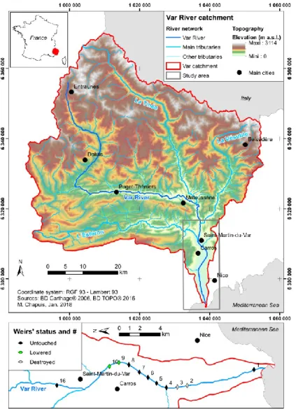
Fig. 1. Var River catchment and location of the study reach in the downstream part of the river. On
the 11 weirs built within this reach, two were destroyed during the 1993 flood and two others are already lowered because of the ongoing restoration project.
Braiding was historically active in the floodplain because of sediment supply from the upstream catchment. Bed surface material is composed of gravel (D50 = 40 mm) with few
patches of sand and silt, thus typical of braiding rivers in the area. However, embankments (for flood and lateral migration risk mitigation, they took place mostly after the second part of the 20th century) and gravel mining significantly modified the fluvial pattern that shifted
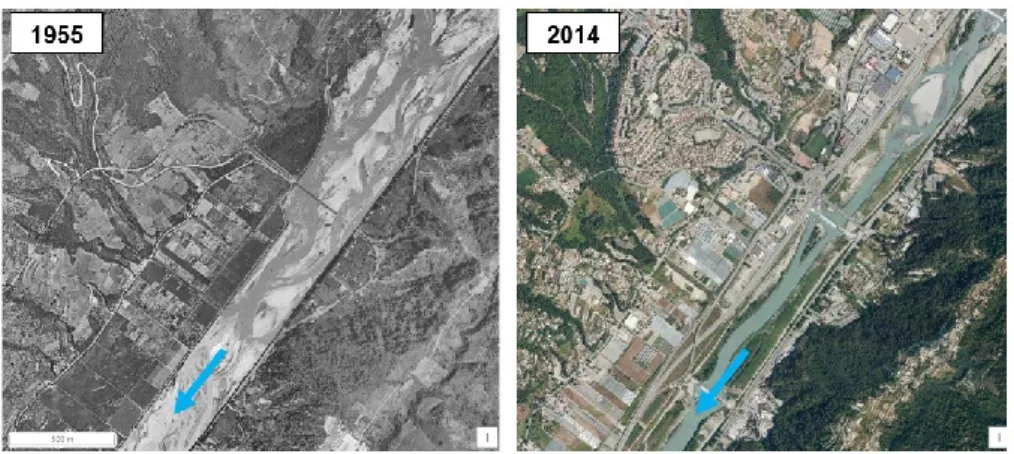
to wandering or even meandering, thus reducing significantly biodiversity [11, in 12]. The downstream reach is thus characterized by heavy channelization that reduced active width from 1000 m to 250 m (fig. 2), and longitudinal profile stabilization (because of gravel mining) through several weirs (initially 11 weirs were built, but weirs #2 and #3 were destroyed during the 1993 flood in the downstream end of the study reach).
The Var River is currently undergoing an ambitious restoration project that aims at restoring its ‘natural’ braiding pattern (‘Mediterranean facies’) on this channelized downstream reach of the river. This restoration project started in 2009 and will continue for several years. It consists in lowering the weir height by 2 m, as and when their sediment continuity reconnection from upstream is obtained. To date, two weirs have been lowered: one in 2009 (weir #9) and the other in 2012 (weir #10). This project is expected to deliver multiple benefits to river ecosystems [6]: active braiding pattern and sediment continuity restoration, flooding risk mitigation, restoration of open landscapes that benefit to biodiversity, ‘natural’ and economical mitigation of vegetation encroachment and groundwater and surface water connectivity.
Fig. 2. Var River catchment and location of the study reach in the downstream part of the river
(modified from: https://remonterletemps.ign.fr).
2.2. Methods
We used LiDAR and orthophoto datasets and performed analyses described in the literature for braiding rivers [1, 2] by adapting the process to channelized rivers. For each combined dataset (2011-2012 and 2013-2014), we digitized morphological units based on orthophotos, then extracted elevation data from the LiDAR dataset and performed analyses using the “R” software in order to extract morphological indicators within the study reach.
We used two main indicators:
The – normalized or not – Bed Relief Index (BRI* and BRI respectively, [1]) that indicates elevation variability within a cross-section for normalized catchment dimensions.
Early in the analysis process, we stressed the importance of using LiDAR and orthophotos datasets that correspond to a unique field campaign, in order to prevent misinterpretation of morphological units during the digitization process (fig. 3). This shall be considered for future planning of data acquisition campaigns.
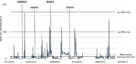
Fig. 3. Var River mean daily discharge during the 2010–2017 period. Qi refers to the return period
associated with values in brackets. Dates of data acquisition are also indicated: dates for LiDAR campaigns are underlined and bold vs. dates for orthophoto campaigns are in italic and bold.
3. Results and interpretation
The study led to a better understanding of the coupled dynamics between hydrology, sediment fluxes, morphology and vegetation dynamics in a Mediterranean river. More specifically in the study reach, this study enabled to better assess the spatial and temporal influence of sediment transport discontinuities and disturbances.
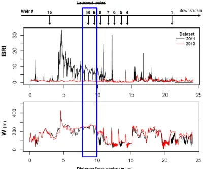
The lower Var River is an active system that quickly recovers its sediment continuity from upstream thanks to the weirs lowering restoration project (fig. 4). Indeed the 2011 dataset (before the lowering of weir #10) shows a different BRI pattern compared to the 2013 dataset: this last one show very low values of BRI, indicating low rugosity within the cross-sections and thus an active braiding pattern.
Fig. 4. Temporal analysis of river indicators: Bed Relief Index (BRI) and active width (W). Lowered
weirs in the restoration project area are indicated (weirs #9 and #10). The BRI enables to discriminate between ‘restored’ reaches (upstream weir #10) and ‘unrestored’ reaches.
For the 2013 dataset, active width (Wrestored = 242 ± 19 m vs. values ranging from
103 ± 53 to 163 ± 53 m for ‘unrestored’ reaches) and normalized bed relief index values (BRI*
restored = 0,003 ± 0,001 vs. 0,003 ± 0,003 to 0,007 ± 0,004 for ‘unrestored’ reaches)
indicate a combination of low rugosity and wide active width (fig. 5). Similar trends would be observed for the 2011 dataset, according to fig. 4. Thus the ‘restored’ reach shows a different set of BRI* and W indices compared to adjacent ‘unrestored’ reaches: the ‘restored’ reach shows a specific pattern with high value of W and narrow standard deviations for both BRI* and W.
Fig. 5. Normalized Bed Relief Index (BRI*) and active width (W) of the Var River reaches compared
4. Conclusion
The ‘restored’ reach shows a different set of indices compared to adjacent ‘unrestored’ reaches, which suggests that these indicators are promising in discriminating ‘restored’ vs. ‘unrestored’ reaches when used together. Indeed, it is the combination of larger active width, and narrower standard deviations for active width and BRI*, that discriminate the restored reach compared to the others.
Adapting existing analysis process from ‘natural’ to ‘channelized’ braiding rivers enabled us to widen the potential application of the tools developed by Lallias-Tacon [2] to modified braiding river systems in order to find quantitative indicators of morphodynamics and ecological functionality of a Mediterranean river. Further research should focus on additional indicators, such as those developed in Rinaldi et al. [14], as this study highlighted the relevance of combining several tools to achieve braiding river characterization in channelized reaches.
References
1. F. Liébault, S. Lallias-Tacon, M. Cassel, N. Talaska, Long profile responses of alpine braided rivers in SE France. River Research and Applications 29(10): 1253–1266. doi: 10.1002/rra.2615, http://onlinelibrary.wiley.com/doi/10.1002/rra.2615/abstract (2013) 2. S. Lallias-Tacon. Analyse spatio-temporelle de la morphologie des rivières en tresses
par LiDAR aéroporté. PhD thesis, Université Lyon 2, France, 213 p.,
https://hal.archives-ouvertes.fr/tel-01548439/document (2015)
3. Agence de l’Eau Rhône Méditerranée Corse, Bassin du Rhône et des cours d'eau côtiers méditerranéens: caractérisation du district et registre des zones protégées adopté par le comité de Bassin du 4 mars 2005: état des lieux: directive cadre européenne sur l'eau... vers le bon état des milieux aquatiques..., Comité de bassin Rhône Méditerranée, 334 p. (2005, in French)
4. Maison Régionale de l’Eau, SOGREAH, H. Gomila, ASCA Consultants, Définition d’une méthode de caractérisation des cours d’eau de type méditerranéen et application dans le cadre de la DCE, 216 p. (2007, in French)
5. B. Terrier, S. Stroffek, Guide technique du SDAGE – Délimiter l’espace de bon fonctionnement des cours d’eau. Agence de l’Eau Rhône Méditerranée Corse, 182 p.,
http://www.rhone-mediterranee.eaufrance.fr/docs/sdage2016/docs-appui/20161201-GuideTechSDAGE-EBFcoursdo-HD.pdf (2017, in French)
6. MA. Leibold, M. Holyoak, N. Mouquet, P. Amarasekare, J.M. Chase, M.F. Hoopes, R.D. Holt, J.B. Shurin, R. Law, D. Tilman, M. Loreau, A. Gonzalez, The metacommunity concept: a framework for multiscale community ecology. Ecology Letters 7(7), 601e613, http://dx.doi.org/10.1111/j.1461-0248.2004.00608.x (2004) 7. T. Datry, N. Bonada, J. Heino, Towards understanding the organisation of
metacommunities in highly dynamic ecological systems. Oikos 125, 149e159, doi: 10.1111/oik.02922, http://onlinelibrary.wiley.com/doi/10.1111/oik.02922/abstract
(2016)
8. H. Piégay, N. Lamouroux, Enlarging spatial and temporal scales for riverine biophysical diagnosis and adaptive management. Journal of Environmental Management 202(Pt 2): 333–336. doi: 10.1016/j.jenvman.2017.07.028,
http://www.sciencedirect.com/science/article/pii/S0301479717306941 (2017)
9. Commission Locale de l'Eau nappe et basse vallée du Var, Schéma d’Aménagement et de Gestion des Eaux de la Nappe et Basse Vallée du Var: plan d’aménagement et de
gestion durable. Conseil départemental des Alpes-Maritimes, Direction de l'Environnement et de la Gestion des Risques, Nice, 178 p.,
https://www.departement06.fr/documents/A-votre-service/Cadre-de-vie/proteger/dpt06-sage-var-pgad.pdf (2015, in French)
10. M. Chapuis, D. Collomb, Healing of French Mediterranean rivers after the great disturbances of the second half of the 20th century: fluvial systems responses and
management strategies. A case study of the Durance River, the Var River and the Cèze River. Revue Méditerranée 118: 65–74. doi:10.4000/mediterranee.6276,
http://journals.openedition.org/mediterranee/6276 (2012)
11. M. Peipoch, M. Brauns, F.R. Hauer, M. Weitere, H.M. Valett, Ecological simplification: Human influences on riverscape complexity. BioScience 65(11): 1057– 1065, https://doi.org/10.1093/biosci/biv120 (2015).
12. F.R. Hauer, H. Locke, V.J. Dreitz, M. Hebblewhite, W.H. Lowe, C.C. Muhlfeld, C.R. Nelson, M.F. Proctor, S.B. Rood, Gravel-bed river floodplains are the ecological nexus of glaciated mountain landscapes. Science Advances 2(6), e1600026. doi: 10.1126/sciadv.1600026 (2016)
13. H. Piégay, A. Alber, L. Slater, L. Bourdin, Census and typology of braided rivers in the French Alps. Aquatic Sciences 71(3): 371–388, https://doi.org/10.1007/s00027-009-9220-4 (2009)
14. M. Rinaldi, B. Belletti, M. Bussettini, F. Comiti, B. Golfieri, B. Lastoria, E. Marchese, L. Nardi, N. Surian, New tools for the hydromorphological assessment and monitoring of European streams. Journal of Environmental Management 202(Pt 2): 363–378. doi: 10.1016/j.jenvman.2016.11.036,