Earthquakes in Switzerland and surrounding regions during 2004
M
ANFREDB
AER, N
ICOLASD
EICHMANN, J
OCHENB
RAUNMILLER, S
TEPHANH
USEN, D
ONATF
ÄH,
D
OMENICOG
IARDINI, P
HILIPPK
ÄSTLI, U
RSK
RADOLFER& S
TEFANW
IEMERKey words: Earthquakes, focal mechanisms, moment tensors, Switzerland
ABSTRACT
This report of the Swiss Seismological Service summarizes the seismic activity in Switzerland and surrounding regions during 2004. During this period, 677 earthquakes and 96 quarry blasts were detected and located in the region under consideration. With 22 events with ML≥ 2.5, the seismic activity in the
year 2004 was close to the average over the last 30 years. As in previous years, most of the activity was concentrated in the Valais and in Graubünden. In ad-dition, several moderate earthquakes occurred in the lower crust below the northern Alpine foreland. Unusual was that five earthquakes were sufficiently strong to cause ground shaking of intensity IV over large portions of the terri-tory. Two were located in Switzerland (Liestal, ML3.8, and Brugg, ML4.0).
The epicenters of the other three strong events were located outside Switzer-land (Besançon in the French Jura, ML 4.8, Waldkirch in southern Germany, ML5.1, and Lago di Garda in northern Italy, ML5.3).
ZUSAMMENFASSUNG
Dieser Bericht des Schweizerischen Erdbebendienstes stellt eine Zusammen-fassung der im Vorjahr in der Schweiz und Umgebung aufgetretenen Erd-beben dar. Im Jahr 2004 wurden im erwähnten Gebiet 677 ErdErd-beben sowie 96 Sprengungen erfasst und lokalisiert. Mit 22 Beben der Magnitude ML≥ 2.5
war die seismische Aktivität im Jahr 2004 nahe dem Durchschnitt. Wie schon in früheren Jahren ereigneten sich die meisten Beben vor allem im Wallis und in Graubünden. Ausserdem gab es wieder einige Beben in der unteren
Kruste des nördlichen Alpenvorlandes. Ungewöhnlich war, dass fünf Erd-beben stark genug waren, um Erschütterungen der Intensität IV über grössere Gebiete des Landes zu verursachen. Zwei davon haben sich in der Schweiz ereignet (Liestal, ML3.8, und Brugg, ML4.0). Die Epizentren der anderen
drei befanden sich hingegen ausserhalb der Schweiz (Besançon im franzö-sischen Jura, ML4.8, Waldkirch in Süddeutschland, ML5.1, und Gardasee in
Norditalien, ML5.3).
RESUME
Le présent rapport du Service Sismologique Suisse résume l’activité sismique en Suisse et dans les régions limitrophes au cours de l’année écoulée. En 2004, 677 tremblements de terre et 96 tirs de carrière furent détectés et localisés. Vingt-deux événements de magnitude ML≥ 2.5 ont été enregistrés; ainsi,
l’ac-tivité sismique de l’année 2004 suivait plus ou moins la moyenne. Comme les années précédentes, l’activité sismique s’est principalement concentrée dans le Valais et les Grisons, mais il y a aussi eu plusiers tremblements de terre dans la croûte inferieure sous l’avantpays nord des Alpes. Cinque tremblements de terre étaient assez inhabituels parce qu’ils ont causé des secousses d’intensité IV dans plusieurs régions du pays. Deux de ces événements ont eu lieu en Suisse (Liestal, ML3.8, et Brugg, ML4.0). Les épicentres des autres trois
évé-nements étaient par contre situés en dehors du pays (Besançon, dans le Jura Français, ML4.8, Waldkirch dans le sud de l’Allemagne, ML5.1, et Lac de
Garde dans le nord de l’Italie, ML5.3).
Swiss Seismological Service, Institute of Geophysics, ETH Hönggerberg, CH-8093 Zürich, Switzerland. (http://www.seismo.ethz.ch) Contribution No. 1428, Institute of Geophysics, ETH-Zürich.
0012-9402/05/030407-12 DOI 10.1007/s00015-005-1168-3 Birkhäuser Verlag, Basel, 2005
Eclogae geol. Helv. 98 (2005) 407–418
Introduction
Past earthquake activity in and around Switzerland has been documented in an uninterrupted series of annual reports from 1879 until 1963 (Jahresberichte des Schweizerischen Erdbeben-dienstes). Three additional annual reports have been published for the years 1972–1974. These reports together with historical records of earthquakes dating back to the 13th century have been summarized by Pavoni (1977) and provided the basis for
the first seismic hazard map of Switzerland (Sägesser & Mayer-Rosa 1978). With the advent of routine data processing by computer, the wealth of data acquired by the nationwide seismograph network has been regularly documented in bul-letins with detailed lists of all recorded events (Monthly Bul-letin of the Swiss Seismological Service). Since 1996, annual re-ports summarizing the seismic activity in Switzerland and sur-rounding regions have been published in the present form
(Baer et al. 1997, 1999, 2001, 2003; Deichmann et al. 1998, 2000a, 2002, 2004). In the course of reassessing the seismic hazard in Switzerland, a new uniform earthquake catalog covering both the historical and instrumental periods has been compiled (Fäh et al. 2003). The data in the new
Earth-quake Catalog of Switzerland (ECOS) are available on line (http://www.seismo.ethz.ch, Swiss Earthquake Catalogs). The new seismic hazard map of Switzerland based on this catalog was officially released in 2004 (Giardini et al. 2004). In addi-tion, numerous studies covering different aspects of the recent seismicity of Switzerland have been published in the scientific literature (for an overview and additional references see, e.g. Deichmann 1990; Pavoni & Roth 1990; Rüttener 1995; Rüt-tener at al. 1996; Pavoni et al. 1997; Deichmann et al. 2000b; Kastrup et al. 2004).
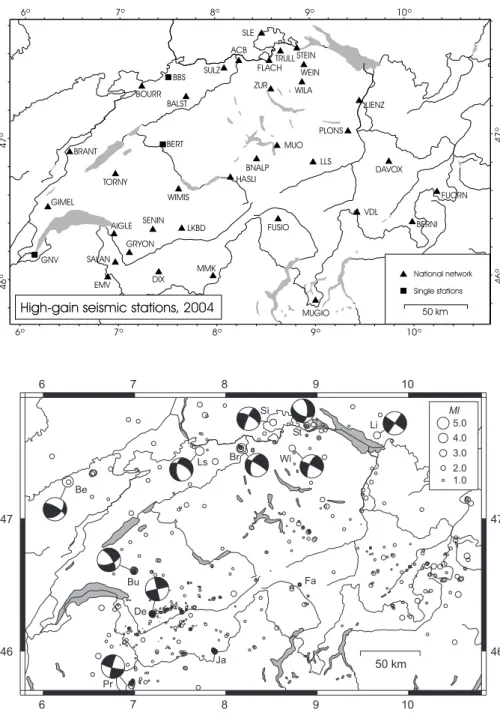
Seismic stations in operation during 2004
The Swiss Seismological Service operates two separate nation-wide seismic networks, a high-gain seismometer network and a low-gain accelerograph network. The former is designed to continuously monitor the ongoing earthquake activity down to magnitudes well below the human perception threshold, whereas the latter is principally aimed at engineering concerns and thus only records so-called strong motions. The observa-tions presented here are based mainly on the high-sensitivity monitoring network. The data collected by the strong-motion network during 2004 is documented separately (Wyss 2005).
Since February 2002, the national high-gain network con-sists almost entirely of digital data acquisition systems with high dynamic range and with either three-component broad-band STS-2 seismometers or Lennartz 5-second sensors (BB and EB in Table 1). For a detailed description of this new data acquisition system, see Baer et al. (2001).
In August 2004, station APL located near Alpnach, OW, which was one of the last two short-period instruments with analog data transmission, ceased functioning and was decom-missioned. The only other significant change with respect to the previous year consisted in the replacement of the excessively noisy station KAMOR by a new station (LIENZ), located close to the site (CHKAM) that had been instrumented temporarily in 2003 (Deichmann et al. 2004). Thus the total number of digi-tal stations in operation in Switzerland remained at 36 during 2004 and the only short-period analog telemetry station left is LKBD2 near Leukerbad (Table 1 and Figure 1).
The data of the national strong-motion network is recorded on site and can be downloaded interactively by telephone (Wyss 2005). To complement this acceleration data with signals that are available in real-time, seven more stations of the broad-band network (BNALP, DIX, EMV, LIENZ, LLS, SULZ and ZUR) have been equipped in 2004 with an additional three-component Kinemetrics EpiSensor accelerometer (Table 1).
Data from foreign networks
For detailed studies of selected earthquakes and for constrain-ing the location and the focal mechanisms of earthquakes situ-ated on the periphery or outside the Swiss station networks, we use additional data obtained from the Erdbebendienst des Landesamtes für Geologie, Rohstoffe und Bergbau Baden
Tab. 1. Seismograph stations operational at the end of 2004. Instrument types: SP = 1 second, EB = 5 seconds, BB = broad band, SM = accelerometer, 1 = vertical component only, 3 = vertical and horizontal components. Signals of LKBD2 and BBS are transmitted via analog telemetry; data of BBS are recorded by the Landeserdbebendienst Baden-Würtemberg and those of BERT and GNV are recorded locally on paper.
National high-gain network recorded in Z¨urich Code Station name Type ACB Acheberg, AG EB-3 AIGLE Aigle, VD BB-3 BALST Balsthal, SO BB-3 BERNI Bernina, GR BB-3 BNALP Bannalpsee, NW BB-3, SM-3 BOURR Bourrignon, JU BB-3, SM-3 BRANT Les Verri`eres, NE BB-3 CHKAM Kamor, SG BB-3 DAVOX Davos, GR BB-3 DIX Grande Dixence, VS BB-3, SM-3 EMV Vieux Emosson, VS BB-3, SM-3 FLACH Flach, ZH EB-3 FUORN Ofenpass, GR BB-3 FUSIO Fusio, TI BB-3 GIMEL Gimel, VD BB-3 GRYON Gryon, VS EB-3 HASLI Hasliberg, BE BB-3 LIENZ Kamor, SG BB-3, SM-3 LKBD Leukerbad, VS EB-3 LKBD2 Leukerbad, VS SP-3 LLS Linth-Limmern, GL BB-3, SM-3 PLONS Mels, SG BB-3 MMK Mattmark, VS BB-3, SM-3 MUGIO Muggio, TI BB-3 MUO Muotathal, SZ BB-3 SALAN Lac de Salanfe, VS EB-3 SENIN Senin, VS BB-3, SM-3 SLE Schleitheim, SH BB-3 STEIN Stein am Rhein, SH EB-3 SULZ Cheisacher, AG BB-3, SM-3 TORNY Torny, FR BB-3 TRULL Trullikon, ZH EB-3 VDL Valle di Lei, GR BB-3, SM-3 WEIN Weingarten, TG EB-3
WILA Wil, SG BB-3
WIMIS Wimmis, BE BB-3 ZUR Z¨urich-Degenried, ZH BB-3, SM-3
Single stations
Code Station name Type BBS Basel-Blauen, BL SP-1 BERT Bern, BE SP-3 GNV Geneva, GE SP-1
Württemberg in Freiburg (LED), from the Zentralanstalt für Meteorologie und Geodynamik in Vienna (ZAMG), from the SISMALP array operated by the Laboratoire de Géophysique Interne et Tectonophysique, Observatoire de Grenoble (LGIT), from the Laboratoire de Détection et Géophysique in Bruyères-le-Châtel (LDG), from the RéNaSS array operat-ed by the Ecole et Observatoire des Sciences de la Terre in Strasbourg, from the Istituto Nazionale di Geofisica e Vul-canologìa in Rome (INGV), and from the Istituto di Geofisica, Università di Genova.
To improve the reliability of automatic locations for events at the periphery or outside of Switzerland we have
implement-ed an automatic system for retrieving near-realtime data from some of the institutions listed above (Baer et al. 2003).
Seismic activity during 2004
Overview
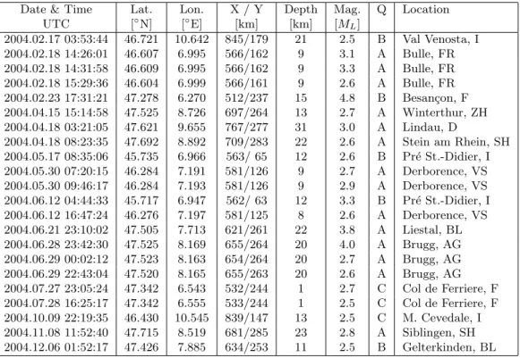
During 2004, the Swiss Seismological Service detected and lo-cated 677 earthquakes in the region shown in Figure 2. Based on such criteria as the time of occurrence, the location, the sig-nal character or on direct information, 96 additiosig-nal seismic events were identified as quarry blasts.
Fig. 1. Seismograph stations in Switzerland oper-ational at the end of 2004.
BBS BOURR DAVOX DIX LLS MMK MUO TORNY SENIN SLE VDL WILA WEIN TRULL STEIN FLACH ACB SULZ LKBD GNV 6o 7o 8o 9o 10o 6o 7o 8o 9o 10o 46 o 47 o 46 o 47 o ZUR 50 km National network Single stations EMV LIENZ BNALP HASLI FUSIO BERNI GIMEL
High-gain seismic stations, 2004 BERT AIGLE WIMIS BALST PLONS FUORN SALAN MUGIO GRYON BRANT
Fig. 2. Epicenters and focal mechanisms of earth-quakes recorded by the Swiss Seismological Ser-vice during 2004. Epicenters of earthquakes men-tioned in the text are Besançon (Be), Brugg (Br), Bulle (Bu), Derborance (De), Faido (Fa), Cima di Jazzi (Ja), Liestal (Ls), Lindau (Ld), Pré St.-Di-dier, Siblingen (Si), Stein am Rhein (St), Win-terthur (Wi). 6 6 7 7 8 8 9 9 10 10 46 46 47 47 50 km Wi St Br Ls Si Li Be Bu Pr Ja De Fa
Magnitude values of the events recorded in 2004 range be-tween ML= 0.1 and 4.8. The events with ML≥ 2.5 and the cri-teria used to assign the quality rating for the given locations as well as the corresponding estimated location accuracy are list-ed in Tables 2 and 3.
Where available, the epicentral coordinates and focal depths given in Table 2 are based on the results that include additional data from foreign networks and on 2-D ray-tracing. For the stronger events, the traditional determination of focal mechanisms from the azimuthal distribution of first-motion polarities (faultplane solutions) has been complemented by a moment tensor based on full-waveform inversion. For these events we list the moment magnitude (Mw) in addition to the local magnitude (ML). Moment magnitude is calculated from
the seismic moment M0obtained from the moment tensor in-version using the relation Mw= (2/3) log M0– 6, where M0is given in N-m (Hanks & Kanamori 1979). The complete set of moment tensors calculated by the Swiss Seismological Service, including plots of all waveform fits, is available on line (http://www.seismo.ethz.ch/mt/). More comprehensive and de-tailed explanations of the data analysis procedures are given in previous annual reports (e.g Deichmann et al. 2004) and can be downloaded from our website (Introduction.pdf under Re-ports at http://www.seismo.ethz.ch).
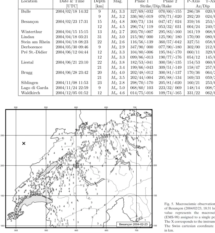
Figure 3 shows the epicenters of the 753 earthquakes with ML≥ 2.5, which have been recorded in Switzerland and sur-rounding regions over the period of 1975 – 2004. The chosen magnitude threshold of 2.5 ensures that the data set is com-plete for the given period and that the number of unidentified quarry blasts and of badly mislocated epicenters is negligible. These events represent less than 10 % of the total number of events detected during that time period in the same area. In what follows, we present the highlights of the seismic activity observed during 2004.
Significant earthquakes of 2004
The sequence of Bulle
On February 18th at 15:26 local time, the region between Lau-sanne and Fribourg was jolted by a first earthquake of
magni-Tab. 2. Earthquakes with ML≥ 2.5. The focal depths of the earthquakes for which focal mechanisms have been calculated are based on 2-D ray-tracing or on
additional data from foreign networks.
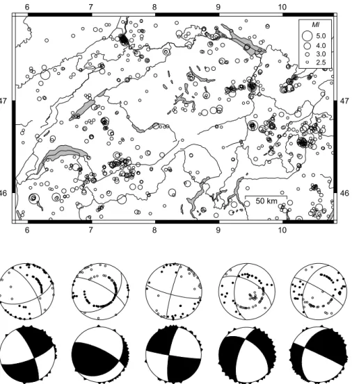
Date & Time Lat. Lon. X / Y Depth Mag. Q Location UTC [◦N] [◦E] [km] [km] [ML] 2004.02.17 03:53:44 46.721 10.642 845/179 21 2.5 B Val Venosta, I 2004.02.18 14:26:01 46.607 6.995 566/162 9 3.1 A Bulle, FR 2004.02.18 14:31:58 46.609 6.995 566/162 9 3.3 A Bulle, FR 2004.02.18 15:29:36 46.604 6.999 566/161 9 2.6 A Bulle, FR 2004.02.23 17:31:21 47.278 6.270 512/237 15 4.8 B Besan¸con, F 2004.04.15 15:14:58 47.525 8.726 697/264 13 2.7 A Winterthur, ZH 2004.04.18 03:21:05 47.621 9.655 767/277 31 3.0 A Lindau, D 2004.04.18 08:23:35 47.692 8.892 709/283 22 2.6 A Stein am Rhein, SH 2004.05.17 08:35:06 45.735 6.966 563/ 65 12 2.6 B Pr´e St.-Didier, I 2004.05.30 07:20:15 46.284 7.191 581/126 9 2.7 A Derborence, VS 2004.05.30 09:46:17 46.284 7.193 581/126 9 2.9 A Derborence, VS 2004.06.12 04:44:33 45.717 6.947 562/ 63 12 3.3 B Pr´e St.-Didier, I 2004.06.12 16:47:24 46.276 7.197 581/125 8 2.6 A Derborence, VS 2004.06.21 23:10:02 47.505 7.713 621/261 22 3.8 A Liestal, BL 2004.06.28 23:42:30 47.525 8.169 655/264 20 4.0 A Brugg, AG 2004.06.29 00:02:12 47.523 8.163 654/264 20 2.7 A Brugg, AG 2004.06.29 22:43:04 47.520 8.165 655/263 20 2.6 A Brugg, AG 2004.07.27 23:05:24 47.342 6.543 532/244 1 2.7 C Col de Ferriere, F 2004.07.28 16:25:17 47.342 6.555 533/244 1 2.5 C Col de Ferriere, F 2004.10.09 22:19:35 46.430 10.545 839/147 13 2.5 C M. Cevedale, I 2004.11.08 11:52:40 47.715 8.519 681/285 23 2.8 A Siblingen, SH 2004.12.06 01:52:17 47.426 7.885 634/253 11 2.5 B Gelterkinden, BL
Tab. 3. Criteria and location uncertainty corresponding to the quality rating (Q) of the hypocentral parameters in Table 2. GAP = largest angle between epicenter and two adjacent stations; DM = minimum epicentral distance; H = horizontal location; Z = focal depth.
Rating Criteria Uncertainty
Q GAP DM H Z (degrees) (km) (km) (km) A ≤ 180 ≤ 1.5×Z ≤ 2 ≤ 3 B ≤ 200 ≤ 25 ≤ 5 ≤ 10 C ≤ 270 ≤ 60 ≤ 10 > 10 D > 270 > 60 > 10 > 10
tude ML3.0. It was followed six minutes later by a second slightly stronger event (ML3.3) and an hour later by a third one with ML2.6. All three were felt by the public. These three stronger events were part of a small sequence of 12 recorded events during the time between January 2nd and October 9th. The epicenters were located about 5 km west of the town of Bulle. Routine hypocenter location gives a focal depth of around 10 km for the strongest and best recorded event. How-ever, with an epicentral distance to the closest station of 20 km, this value is poorly constrained. Using a 3D velocity model (Husen et al. 2003) and Pn arrivals out to distances of more than 200 km gives a focal depth of 9 km. This value is the most likely focal depth and is confirmed by 2D ray tracing along a profile trending NE from the epicenter and by the result of the full-waveform moment tensor inversion. For the strongest of theses events, both the moment tensor and the faultplane solu-tion based on first mosolu-tion polarities result in a strike-slip focal mechanism with a slight normal-faulting component (Figure 4 and Table 4). Based on the strong waveform similarity and the almost identical P to S amplitude ratios, it is evident that the
three strongest events occurred almost at the same location and with the same focal mechanism. The moment magnitude, Mw, is 3.0 for the first and 3.2 for the second of the two strongest events. The WNW-ESE orientation of the P-axis and the corresponding NNE-SSW orientation of the T-axis are what one would expect from the stress field deduced from pre-vious earthquakes in the Alpine foreland of western Switzer-land (Kastrup et al. 2004).
Besançon – Roulans
The strongest event of 2004 in the region covered by the map in Figure 2 occurred on February 23rd at 18:31 local time. Its epicenter was located in the French Jura, near the town of Roulans, approximately 20 km NE of Besançon. According to a compilation of the Bureau Central Sismologique Français, this earthquake caused some light damage in the epicentral area, so that the epicentral intensity I0was estimated to be V-VI on the European Macroseismic Scale (BCSF 2004). As shown in Figure 5, it was clearly felt (intensity IV) across most
Fig. 3. Epicenters of earthquakes with Magni-tudes ML≥ 2.5, during the period 1975 – 2004. 6 6 7 7 8 8 9 9 10 10 46 46 47 47 50 km
Fig. 4. Faultplane solutions (above) based on first-motion polarities and moment tensors (below) based on full-waveform inversion (lower hemisphere, equal area projection). In the fault-plane solutions, solid circles correspond to com-pressive first motion (up) and empty circles to di-latational first motion (down); on the moment tensors, triangles show the station locations. Bulle 2004.02.18 Besançon 2004.02.23 Pré St.-Didier 2004.06.12 Liestal 2004.06.21 Brugg 2004.06.28
Location Date & Time Depth Mag. Plane 1 Plane 2 P-Axis T-Axis
[UTC] [km] Strike/Dip/Rake Az/Dip
Bulle 2004/02/18 14:32 9 ML3.3 327/69/-032 070/60/-155 286/38 020/05 9 Mw 3.2 336/80/-019 070/71/-020 292/20 024/06 Besan¸con 2004/02/23 17:31 15 ML4.8 300/73/ 134 047/47/ 024 359/16 253/44 12 Mw 4.5 296/74/ 119 053/32/ 031 004/24 240/53 Winterthur 2004/04/15 15:15 13 ML2.7 203/70/-007 295/83/-160 161/19 068/09 Lindau 2004/04/18 03:21 31 ML3.0 215/90/ 000 125/90/ 180 170/00 080/00 Stein am Rhein 2004/04/18 08:23 22 ML2.6 116/56/-139 360/57/-042 327/51 058/01 Derborence 2004/05/30 09:46 9 ML2.9 347/90/ 000 077/90/-180 302/00 212/00 Pr´e St.-Didier 2004/06/12 04:44 12 ML3.3 104/80/-006 195/84/-170 060/11 329/03 12 Mw 3.3 099/86/-013 190/77/-176 054/12 145/06 Liestal 2004/06/21 23:10 22 ML3.8 182/53/-041 300/58/-135 154/53 060/03 21 Mw 3.4 199/66/-043 309/51/-149 158/47 257/09 Brugg 2004/06/28 23:42 20 ML4.0 202/48/-012 300/81/-137 170/36 064/21 21 Mw 3.5 202/44/-004 295/88/-134 169/33 059/28 Siblingen 2004/11/08 11:53 23 ML2.8 298/70/-170 205/81/-020 160/21 253/07 Lago di Garda 2004/11/24 22:59 9 Mw 5.0 068/60/ 103 223/32/ 069 148/14 008/72 Waldkirch 2004/12/05 01:52 12 Mw 4.6 014/75/-016 109/74/-165 331/22 062/01
of western and northern Switzerland. Magnitudes calculated by the Swiss Seismological Service are ML 4.8 and Mw4.5. Local magnitudes reported by other institutions are in part sig-nificantly higher: 5.0 (LED Jahresbulletin 2004), 5.1 (RéNaSS) and 5.9 (LDG; BCSF, 2004). One aftershock, on Feb. 26th at 01:58 local time, was strong enough (ML2.1) to trigger the Swiss network. Locations based both on 1D and 3D crustal models give focal depths in the range between 11 and 17 km.
Given that the closest epicentral distance is over 40 km, these depth values are unreliable. The best fit of the full-waveform inversion is obtained for 12 km and a good match between ob-served and calculated travel-time differences for 2D raytrace profiles trending SE and E is obtained for 15 and 16 km. In Table 2 and for calculating take-off angles for the faultplane solution, the focal depth was fixed at 15 km. Both the moment tensor and the faultplane solution correspond to an oblique
Tab. 4. Focal mechanism parameters based on first-motion polarities (lines with ML) and full-waveform inversion (lines with Mw).
Fig. 5. Macroseismic observations for the event of Besançon (2004/02/23, 18:31 local time). Each value represents the macroseismic intensity (EMS-98) assigned to a single postal code zone. The X corresponds to the instrumental epicenter. The Swiss cartesian coordinate grid is labeled in km.
thrust (Table 4 and Figure 4). The strike and dip of the NW-SE trending nodal plane is very well constrained by the ob-served first motion polarities and differ by less than 5 degrees from the moment tensor solution. For some stations, later ar-rivals with impulsive onsets, which could be identified un-equivocally as direct waves based on 2D ray tracing, were also used in the faultplane solution. The orientation of the other nodal plane and thus the degree of thrusting depend strongly on the take-off angles of the negative onsets observed in the SE quadrant of the faultplane solution. Whereas the strike of this nodal plane differs by only 5 degrees between faultplane solution and moment tensor, the dip differs by 14 degrees. Nevertheless, both the style of faulting and the orientation of the P-axis are well constrained and are rather unusual. Earth-quakes with a strong thrust component are rare in the crys-talline basement of the northern Alpine foreland, and from an extrapolation of regional stress inversions one would expect a NW-SE oriented P-axis rather than the observed N-S orienta-tion (Müller et al. 1992; Delouis et al., 1993; Plenefisch & Bon-jer 1997; Kastrup et al. 2004).
Seismic events and rockbursts in the new Gotthard tunnel Between March 26th and April 16th, 2004, a small earthquake sequence of five events with magnitudes MLbetween 0.9 and 1.4 occurred near Faido, TI. This sequence was not recognised as being anything unusual, until it became known that both the time of occurrence and the epicentral location of these events correlate with some rather violent rockbursts in a section of the new Gotthard railroad tunnel, that is still under construc-tion. Given that the seismic activity has flared up again in 2005, the causal relation between the earthquakes, rockbursts and observed deformation of the tunnel cross-section is the object of further studies, that include the deployment of an additional temporary network of seismometers in the epicentral area.
Winterthur
Despite its small magnitude (ML2.7), this earthquake, that oc-curred on April 15th at 17:15 local time near Winterthur, was felt by a few people. With good azimuthal station coverage and with two stations at epicentral distances close to the focal depth, both the epicenter location and the focal depth of 13 km are well constrained. The strike-slip focal mechanism with NNE-SSW and ENE-WSW oriented P- and T-axes (Figure 6) is typical for midcrustal earthquakes in northeastern Switzer-land (Deichmann et al. 2000b; Kastrup et al. 2004).
Lindau
The earthquake with ML3.0 that occurred at 05:21 local time on April 18th NE of Lake Constance near the town of Lindau was the deepest event recorded in 2004 in and around Switzerland. Focal depths for this event determined routinely with a 1D ve-locity model range between 29 and 33 km. The location based on the 3D model of Husen et al. (2003) also gives a focal depth of 33 km. Modelling of travel-time differences between the di-rect arrival (Pg) and the refracted at the Moho (Pn) shows that the source must be one or two km above the Moho, which ac-cording to Waldhauser et al. (1998) is at a depth of 32 km. In Table 2 and for calculating take-off angles for the faultplane so-lution, the focal depth was thus fixed at 31 km. Although the available first-motion data allow for some variability in strike and dip of the nodal planes, the style of faulting (strike-slip) is unambiguous (Figure 6). Both the orientation of the P- and T-axes and the focal depth are not unusual for northeastern Switzerland and the neighboring parts of southern Germany. In 2001 an earthquake with ML2.9, a focal depth of 30 km and a similar strike-slip mechanism occurred near Oberriet, SG, just 30 km to the south of the Lindau event (Deichmann et al. 2002).
Stein am Rhein
This small earthquake (ML2.6), which occurred only 5 hours after the Lindau event, was located at a depth of 22 km just north of Stein am Rhein. The high station density provided by the newly installed instruments in northeastern Switzerland in 2003 and by the stations in southern Germany provide an ex-cellent azimuthal coverage and thus a reliable location and a well-determined faultplane solution (Figure 6). With four sta-tions within an epicentral distance of less than 20 km, the focal depth is also well constrained. The oblique normal faulting mechanism with a ENE-WSW striking T-axis is similar to that of the ML4.2 event that occurred near Steckborn in 1986 (De-ichmann et al. 2000b; Kastrup et al. 2004).
The sequence of Pré St.-Didier
Between April 15th and November 9th the Swiss seismograph network recorded a sequence of 17 events near Pré St.-Didier, east of Courmayeur, Italy. The magnitudes range between ML 0.9 and 3.3. Five of these events, including one with ML2.6, oc-curred on May 17th and four, including the strongest event, on June 12th (Table 2). Because of their location outside of the Swiss network, the quality of the routine epicenter
determina-Fig. 6. Faultplane solutions based on first-motion polarities for four small earthquakes in northeast-ern Switzerland. Winterthur 2004.04.15 Lindau 2004.04.18 Stein am Rhein 2004.04.18 Siblingen 2004.11.08 Derborence 2004.05.30
tion is poor and the focal depth can not be determined. For the strongest event, we merged the Swiss data with the waveforms obtained from the universities of Genova and of Grenoble. To ensure a sufficiently good azimuthal coverage and to minimize the effects of crustal heterogeneity, for the final location we used 16 P and 5 S readings at stations out to 70 km. Despite this measure, some traveltime residuals, in particular for the S-readings, remain high, indicating that the crustal model used is probably unsuitable for this region. Thus, given also that the epicentral distance to the closest station is 19 km, the resulting focal depth of 7 km is not reliable. The optimal depth obtained from matching the waveforms in the inversion for the moment tensor as well as the travel-time differences between the direct waves (Pg) and the waves refracted at the Moho (Pn) along a 2D ray-trace profile across the Alps and northern Alpine fore-land is 12 km. This is the depth that was used to calculate the take-off angles of the rays at the source for the faultplane solu-tion. However it was not possible to construct a completely self-consistent faultplane solution. The result shown in Figure 4 and listed in Table 4 is the one with a minimum number of inconsistent polarities (3) that most closely matches the mo-ment tensor solution. While the exact orientation of the nodal planes, because of the remaining inconsistencies, is still slightly ambiguous, the style of faulting (strike-slip) is well constrained by both the faultplane solution and the moment tensor. The orientation of the T-axis at a high angle to the strike of the Alpine chain in this area is typical for the extensional regime observed in many zones of high elevations in the Alps (e.g. Maurer et al. 1997; Eva et al. 1998; Kastrup et al. 2004).
The sequence of Derborence
In Table 2, we list three events with magnitudes ML2.7, 2.9
and 2.6 at location Derborence. The two strongest ones
oc-curred within a few hours of each other on May 30th. All three are part of an earthquake sequence comprising 173 de-tected events in the magnitude range between 0.2 and 2.9. As shown in Figure 7, the first event was recorded on March 25th and the last one on November 11th. However, the main activ-ity (165 events) was concentrated between April 13th and June 25th, with the peaks, in terms of number of events per 24 hours, on May 21st-22nd (17 events) and on June 24th-25th (12 events). It is noteworthy that after this last activity spurt the event frequency dropped very abruptly and that the three strongest events occurred during a period of relative quiescence. Routine locations put the epicenter of this cluster near Pas de Cheville, located 2 km south of the summit of Les Diablerets, and epicenters of 90% of the events are scat-tered within a radius of 1 km about the mean location. Based on the high degree of signal similarity, these events are prob-ably clustered even more tightly in reality, but this would need to be verified by signal correlation and relative location
Fig. 7. Magnitudes and cumulative number of events for the Derborence earthquake sequence. 3 2 1 0 100 150 200 250 300 Julian day 0 50 100 150 200 250 300 Cumulative number of event s Magnitude Derborence 25.03. - 11.11.2004
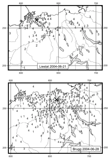
Fig. 8. Macroseismic observations for the events of Liestal (2004/06/22 01:10 local time) and Brugg (2004/06/29, 01:42 local time). Otherwise as in Figure 5.
procedures. Routinely calculated focal depths range between 6 and 9 km. Modelling of travel-time differences between Pn and Pg at stations in northern Switzerland and southern Ger-many suggests a depth of 9 km. The faultplane solution for the strongest event based on the available first-motion data is compatible with a pure strike-slip focal mechanism (Table 4 and Figure 6), with one of the nodal planes striking in the same diretion as the general trend of the epicenter alignment in the northern Valais (Figure 2). Whereas this nodal plane is well contrained by the data, the orientation of the other nodal plane is poorly determined. It is thus possible that the actual direction of slip was more oblique than suggested by Figure 6, but this would not change the NW-SE and NE-SW orientation of the P- and T-axes significantly.
Liestal
The earthquake, which occurred during the night of June 21st to 22nd near Liestal, BL, woke up many people in northwest-ern Switzerland. The epicentral intensity reached IV and mag-nitudes are ML3.8 and Mw3.4 (Figure 8). Given a large num-ber of strong-motion stations in the Basel area, the focal depth of 22 km is well constrained by 14 records within an epicentral distance of less than 20 km. Thanks to the excellent azimuthal distribution of records from seismic stations in southern Ger-many as well as in Switzerland, the normal faulting focal mech-anism with an ENE-WSW oriented T-axis obtained from the faultplane solution is also very well determined (Figure 4). The moment tensor has a slightly stronger strike-slip component and its T-axis is rotated clockwise by 17 degrees with respect to the faultplane solution (Table 4). No aftershocks were detect-ed for this earthquake.
Brugg
Almost exactly one week after the Liestal event, during the night of June 28th to 29th, another moderate earthquake pro-duced shaking of intensity IV over most of northern Switzer-land (Figure 8). Magnitude values computed for this event are ML4.0 and Mw3.5. The focal depth, constrained by clear P- and S-arrivals at stations SULZ and ACB, located at epi-central distances of 4 and 9 km, is 20 km. The faultplane solu-tion and the moment tensor are well determined and almost identical (Figure 4 and Table 4). The resulting focal mecha-nism is rather unusual: it corresponds either to lateral motion on a flatly dipping NNE-SSW striking faultplane or to oblique normal faulting on an almost vertical NW-SE striking faultplane. However, the ENE-WSW orientation of the T-axis agrees with the regional deformation pattern and stress regime of the region (Deichmann et al. 2000b; Kastrup et al. 2004). This earthquake was followed by seven aftershocks with MLbetween 0.7 and 2.7. The first four occurred within 24 hours of the mainshock, the next two followed on July 2nd and 10th, and the last one occurred almost six months later, on October 10th. The earthquake of Brugg and its
after-shocks occurred in a previously aseismic area of northern Switzerland. Practically no other earthquake had been de-tected in this area since the beginning of modern instrumen-tal monitoring in 1975, and at most one single comparable event is likely to have occurred here since the foundation of the Swiss Earthquake Commission in 1878 (Deichmann et al. 2000b). It is noteworthy that, judging from Figure 8, the event of Brugg seems to have been felt much more widely than the Liestal event, although their magnitudes MLdiffer by only 0.2 units and they both occurred at the same time of day, at almost the same focal depth and in the same general region.
Siblingen
The small event (ML2.8) that occurred on November 8th near Siblingen, NW of Schaffhausen, is another one of those lower-crustal earthquakes commonly observed below the northern Alpine foreland. Its location and focal depth of 23 km are well constrained by a uniform azimuthal station distribution and by three stations within an epicentral distance of 20 km. The well-determined strike-slip mechanism with an ENE-WSW orient-ed T-axis (Figure 6) is typical for northeastern Switzerland (Deichmann et al. 2000b; Kastrup et al. 2004).
Lago di Garda, northern Italy
One minute before midnight, local time, on November 24th, a moderately strong earthquake in northern Italy caused ground shaking that woke up many people in southern and southeast-ern Switzerland (Figure 9). The epicenter was located near the town of Saló, W of Lake Garda. In the epicentral region the shaking was severe, causing the collapse of several poorly built
Fig. 9. Macroseismic observations for the event of Lago di Garda (2004/11/24, 23:59 local time). Otherwise as in Figure 5.
houses and forcing people to abandon some heavily damaged buildings. This corresponds to an epicentral intensity I0 of VII–VIII. Although the epicenter of this event was located outside the area covered by the map in Figure 2, we mention it here, because it was the strongest earthquake in 2004 that pro-duced significant ground shaking in Switzerland. In fact in can-ton Ticino it caused the most intense shaking in many years and intensities of IV were observed as far north as Lucerne. Magnitudes calculated by the Swiss Seismological Service are ML5.3 and Mw5.0, which agree well with the values of ML5.2 and Mw5.0 published by INGV (2004). The focal mechanism derived from the moment tensor inversion is a thrust fault with a NW-SE oriented P-axis at a depth of 9 km (Figure 11 and Table 4), which also differs only little from results obtained by INGV (2004).
Waldkirch, southern Germany
Another earthquake in 2004, which caused significant shaking in Switzerland and was located outside the map in Figure 2, occurred on December 5th at 02:52 local time. The epicenter was in southern Germany near the town of Waldkirch, about 17 km north of Freiburg im Breisgau. Magnitude values com-puted by the Swiss Seismological Service are ML5.1 and Mw 4.6, and the focal depth corresponding to the best fit of the mo-ment tensor inversion is 12 km. Despite the relatively small difference in MLwith respect to the event of Lago di Garda, structural damage was only slight, being limited to minor cracks in walls and chimneys and some fallen roof shingles (LED 2004). Thus the epicentral intensity was not greater than VI, but it was nevertheless clearly felt over most of northern Switzerland and some people were awakened as far south as Chur and Interlaken (Figure 10). The moment tensor corre-sponds to a strike-slip focal mechanism with sinistral slip on a NNE-SSW striking fault or dextral slip on a WNW-ESE strik-ing fault (Figure 11 and Table 4). The orientation of the NW-SE and NE-SW orientation of the P- and T-axes matches the stress field derived from other earthquakes in the crystalline basement of the Black Forest (Plenefisch & Bonjer 1997).
Discussion
On a global level, the seismicity of the year 2004 will undoubt-edly be remembered for the enormous earthquake on Decem-ber 26th off the west coast of Sumatra, which was one of the two or three largest earthquakes of the past century and which caused one of the most disastrous tsunamies in known history.
Fig. 10. Macroseismic observations for the event of Waldkirch (2004/12/05, 02:52 local time). Otherwise as in Figure 5.
Fig. 11. Moment tensors of the Lago di Garda and Waldkirch events.
Although the direct seismological consequences of this earth-quake were comparably insignificant for Switzerland, it is noteworthy that the broad-band seismometers of the Swiss Seismological Service recorded a vertical displacement of more than 2 cm as the long-period surface waves propagated across the country.
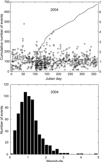
On a local scale, the five earthquakes in 2004 that pro-duced ground shaking of intensity IV over large regions of the country were somewhat unusual and served to remind the pub-lic that seismic hazard is a concern also for Switzerland. Never-theless, in terms of numbers of recorded earthquakes, the year 2004 in Switzerland and immediate surroundings was not out of the ordinary. Averaged over the last 30 years, we observe about 25 events with ML≥ 2.5 and 8 events with ML≥ 3 per year. With 22 ML≥ 2.5 events and 7 events reaching ML≥ 3 in 2004 (Table 2 and Fig. 12), the seismic activity in these magni-tude ranges was thus close to the 30 year average.
The enhanced activity in April and May, visible in the plot of the temporal evolution of seismicity (Julian days 100–150 in Fig. 12), corresponds to the earthquake sequence of Der-borence, which alone contributes 25 % to the total number of recorded earthquakes in 2004. The seismic activity in the re-gion of Cima di Jazzi, between Zermatt and Macugnaga, which started in 2002 (Baer et al. 2003, Deichmann et al. 2004), flared up again in March 2004 and continued throughout the whole year with an additional 31 events ranging in magnitude be-tween 0.9 and 2.3. Moreover, in autumn a small cluster of a dozen events with magnitudes between 0.4 and 1.9 appeared near Sierre. Thus the large total number of detected earth-quakes (677) in 2004, compared to previous years, is due in part to these earthquake sequences and in part to an increase in sensitivity of the high-gain network since switching the event detection from the old analog data acqusition system to the new broad-band digital instrumentation at the end of August 2001 (Deichmann et al. 2002).
As in previous years, most of the earthquakes occurred in the Valais and in Graubünden. However, the strongest events (Besançon, Brugg and Liestal) occurred below the northern Alpine foreland. Routinely calculated focal depths for the 677 earthquakes recorded in 2004 range between 0 and 31 km, but only 39 of these hypocenters are deeper than 15 km. As in the past (e.g. Deichmann et al. 2000a), almost all these deep sources, and in particular the magnitude ML4.0 event of Brugg with its 7 aftershocks, are located in the lower crust beneath the Jura Mountains or the Molasse Basin of northern Switzerland. Acknowledgements
Monitoring the seismicity in a small country is not possible without interna-tional cooperation. We thank all individuals who kindly responded to our re-quests for information and data: W. Brüstle, S. Mellert and S. Stange of the Erdbebendienst des Landesamtes für Geologie, Rohstoffe und Bergbau Baden Württemberg in Freiburg, D. Spallarossa, S. Solarino and E. Eva of the University of Genova, R. DiStefano of the Istituto Nazionale di Geofisica e Vulcanologìa, Rome, F. Thouvenot of the Observatoire de Grenoble. We are also very grateful to our colleagues in the electronics lab, Ch. Bärlocher, M. Grieder, B. Rinderknecht, M. Schild and P. Zweifel, for their relentless efforts in ensuring the continuous reliability of the data acquisition systems and to A. Blanchard for logistic support. Financial support from the Nationale Genossenschaft für die Lagerung radioaktiver Abfälle, Nagra, for the opera-tion of the staopera-tions in northeastern Switzerland, as well as from the BLS Alp-Transit for the operation of the two stations near Leukerbad is gratefully ac-knowledged.
REFERENCES
BAER, M., DEICHMANN, N., FÄH, D., KRADOLFER, U., MAYER-ROSA, D.,
RÜTTENER, E., SCHLER, T., SELLAMI, S., SMIT, P. 1997: Earthquakes in
Switzerland and surrounding regions during 1996. Eclogae geol. Helv. 90/3, 557–567.
BAER, M., DEICHMANN, N., BALLARINDOLFIN, D., BAY, F., DELOUIS, B., FÄH, D., GIARDINI, D., KASTRUP, U., KIND, F., KRADOLFER, U., KÜNZLE, W.,
RÖTHLISBERGER, S., SCHLER, T., SELLAMI, S., SMIT, P., SPÜHLER, E. 1999:
Earthquakes in Switzerland and surrounding regions during 1998. Eclogae Geol. Helv. 92/2, 265–273.
Fig. 12. Earthquake activity during 2004: magnitude of each event and cumu-lative number of events (above); histogram of magnitudes (below).
0 50 100 150 200 250 300 350 0 1 2 3 4 5 6 7 700 600 500 400 300 200 100 0 Cumulative number of event s Julian day Magnitude 2004 Magnitude Number of event s 2004 120 100 80 60 40 20 0 0 1 2 3 4 5
BAER, M., DEICHMANN, N., BRAUNMILLER, J., BALLARINDOLFIN, D., BAY, F.,
BERNARDI, F., DELOUIS, B., FÄH, D., GERSTENBERGER, M., GIARDINI, D.,
HUBER, S., KASTRUP, U., KIND, F., KRADOLFER, U., MARAINI, S., MATTLE, B., SCHLER, T., SALICHON, J., SELLAMI, S., STEIMEN, S., WIEMER, S. 2001: Earthquakes in Switzerland and surrounding regions during 2000. Eclogae Geol. Helv. 94/2, 253–264.
BAER, M., DEICHMANN, N., BRAUNMILLER, J., BERNARDI, F., CORNOU, C., FÄH, D., GIARDINI, D., HUBER, S., KÄSTLI, P., KIND, F., KRADOLFER, U., MAI, M., MARAINI, S., OPRSAL, I., SCHLER, T., SCHORLEMMER, D.,
SELLAMI, S., STEIMEN, S., WIEMER, S., WÖSSNER, J., WYSS, A. 2003:
Earth-quakes in Switzerland and surrounding regions during 2002. Eclogae Geol. Helv. 96/2, 313–324.
BCSF 2004: http://eost.u-strasbg.fr/bcsf/Accueil.html, publications, Les notes du BCSF, Le séisme de Roulans (23/02/2004) – Note préliminaire.
DEICHMANN, N. 1990: Seismizität der Nordschweiz, 1987–1989, und
Auswer-tung der Erdbebenserien von Günsberg, Läufelfingen und Zeglingen. Nagra Technischer Bericht, NTB 90–46, Nagra, Baden.
DEICHMANN, N., BAER, M., BALLARIN DOLFIN, D., FÄH, D., FLÜCK, P.,
KASTRUP, U., KRADOLFER, U., KÜNZLE, W., MAYER-ROSA, D., RÖTHLIS
-BERGER, S., SCHLER, T., SELLAMI, S., SMIT, P., & GIARDINI, D. 1998:
Earthquakes in Switzerland and surrounding regions during 1997. Eclogae geol. Helv. 91/2, 237–246.
DEICHMANN, N., BAER, M., BRAUNMILLER, J., BALLARINDOLFIN, D., BAY, F.,
DELOUIS, B., FÄH, D., GIARDINI, D., KASTRUP, U., KIND, F., KRADOLFER,
U., KÜNZLE, W., RÖTHLISBERGER, S., SCHLER, T., SALICHON, J., SELLAMI, S., SPÜHLER, E., WIEMER, S. 2000a: Earthquakes in Switzerland and sur-rounding regions during 1999. Eclogae Geol. Helv. 93/3, 395–406.
DEICHMANN, N., BALLARINDOLFIN, D., KASTRUP, U. 2000b: Seismizität der
Nord- und Zentralschweiz. Nagra Technischer Bericht, NTB 00-05, Nagra, Wettingen.
DEICHMANN, N., BAER, M., BRAUNMILLER, J., BALLARINDOLFIN, D., BAY, F.,
BERNARDI, F., DELOUIS, B., FÄH, D., GERSTENBERGER, M., GIARDINI, D.,
HUBER, S., KRADOLFER, U., MARAINI, S., OPRSAL, I., SCHIBLER, R.,
SCHLER, T., SELLAMI, S., STEIMEN, S., WIEMER, S., WÖSSNER, J., WYSS, A.
2002: Earthquakes in Switzerland and surrounding regions during 2001. Eclogae Geol. Helv. 95/2, 249–261.
DEICHMANN, N., BAER, M., BRAUNMILLER, J., CORNOU, C., FÄH, D., GIARDINI,
D., GISLER, M., HUBER, S., HUSEN, S., KÄSTLI, P., KRADOLFER, U., MAI, M., MARAINI, S., OPRSAL, I., SCHLER, T., SCHORLEMMER, D., WIEMER, S.,
WÖSSNER, J., WYSS, A. 2004: Earthquakes in Switzerland and surrounding
regions during 2003. Eclogae Geol. Helv. 97/3, 447–458.
DELOUIS, B., HAESSLER, H., CISTERNAS, A., RIVERA, L. 1993: Stress tensor
determination in France and neighbouring regions. Tectonophysics, 221, 413–437.
EVA, E., PASTORE, S., DEICHMANN, N. 1998: Evidence for ongoing extensional deformation in the western Swiss Alps and thrust-faulting in the south-western Alpine foreland. Journal of Geodynamics 26/1, 27–43.
FÄH, D., GIARDINI, D., BAY, F., BERNARDI, F., BRAUNMILLER, J., DEICHMANN, N., FURRER, M., GANTNER, L., GISLER, M., ISENEGGER, D., JIMENEZ, M.-J., KÄSTLI, P., KOGLIN, R., MASCIADRI, V., RUTZ, M., SCHEIDEGGER, C.,
SCHIBLER, R., SCHORLEMMER, D., SCHWARZ-ZANETTI, G., STEIMEN, S.,
SELLAMI, S., WIEMER, S., WÖSSNER, J. 2003: Earthquake catalog of
Switzerland (ECOS) and the related macroseismic database. Eclogae Geol. Helv. 96/2, 219–236.
GIARDINI, D., WIEMER, S., FÄH, D., DEICHMANN, N., SELLAMI, S., JENNI, S.
and the Hazard Team of the Swiss Seismological Service 2004: Seismic Hazard Assessment 2004. Swiss Seismological Service, 81 pp.
HANKS, T. C. ANDH. KANAMORI(1979). A moment magnitude scale, J. Geo-phys. Res. 84, B5, 2348–2350.
HUSEN, S., KISSLING, E., DEICHMANN, N., WIEMER, S., GIARDINI, D., BAER, M. 2003: Probabilistic earthquake location in complex three-dimensional velocity models: Application to Switzerland. J. Geophys. Res. 108, B2, 2077–2096.
INGV 2004: http://www.ingv.it/terremoti/bresciano2004/bresciano.html
KASTRUP, U., ZOBACK M.-L., DEICHMANN, N., EVANS, K., GIARDINI, D.,
MICHAEL, A.J. 2004: Stress field variations in the Swiss Alps and the
northern Alpine foreland derived from inversion of fault plane solutions. J. Geophys. Res. 109, B1, doi:10.1029/2003JB002550B01402.
LED 2004: http://www.lgrb.uni-freiburg.de/lgrb/Fachbereiche, Erdbeben-dienst, Jahresbulletins, Bulletin 2004.
MAURER, H., BURKHARD, M., DEICHMANN, N., GREEN, A.G. 1997: Active
Tec-tonism in the Western Swiss Alps. Terra Nova 9, 91–94.
MÜLLER, B., ZOBACK, M.-L., FUCHS, K., MASTIN, L.G., GREGERSEN, S.,
PAVONI, N., STEPHANSSON, O., LJUNGGREN, C. 1992: Regional patterns of
tectonic stress in Europe. J. Geophys. Res. 89, B13, 11’517–11’526.
PAVONI, N. 1977: Erdbeben im Gebiet der Schweiz. Eclogae geol. Helv. 70/2,
351–370.
PAVONI, N. & ROTH, P. 1990: Seismicity and seismotectonics of the Swiss Alps.
Results of microearthquake investigations 1983–1988. In: Deep Structure of the Alps. (Ed. by F. ROURE, P. HEITZMANN ANDR. POLINO). Mem. Soc. geol. France, N. S. 156, 129–134.
PAVONI, N., MAURER, H., ROTH, P., DEICHMANN, N. 1997: Seismicity and
seis-motectonics of the Swiss Alps. In: Deep structure of the Swiss Alps, re-sults of NRP 20, Birkhäuser, Basel, 241–250.
PLENEFISCH, T. & BONJER, K.-P. 1997: The stress field in the Rhinegraben area
inferred from earthquake focal mechanisms and estimation of frictional parameters. Tectonophysics 275, 71–97.
RÜTTENER, E. 1995: Earthquake hazard estimation for Switzerland. Matér.
Géol. Suisse, Geophys. Nr. 29, Schweizerische Geophysikalische Kommis-sion, ETH-Zürich, 106 pp.
RÜTTENER, E., EOGOZCUE, J., MAYER-ROSA, D., MUELLER, S. 1996: Bayesian
estimation of seismic hazard for two sites in Switzerland. Natural Hazards 14, 165–178.
SÄGESSER & MAYER-ROSA 1978: Erdbebengefährdung in der Schweiz.
Schweizerische Bauzeitung 78/7, 3–18.
WALDHAUSER, F., KISSLING, E., ANSORGE, J., MUELLER, ST. 1998:
Three-dimensional Interface Modeling with two-Three-dimensional Seismic Data: the Alpine Crust-Mantle boundary. Geoph. J. Int. 135, 264–278.
WYSS, A. 2005: Swiss National Strong Motion Network: Strong Motion Bul-letin, January 2004 – December 2004. Publ. Series of the Swiss Seismolog-ical Service, Nr. 117, ETH-Zürich.