Publisher’s version / Version de l'éditeur:
Vous avez des questions? Nous pouvons vous aider. Pour communiquer directement avec un auteur, consultez la première page de la revue dans laquelle son article a été publié afin de trouver ses coordonnées. Si vous n’arrivez pas à les repérer, communiquez avec nous à [email protected]. Questions? Contact the NRC Publications Archive team at
[email protected]. If you wish to email the authors directly, please see the first page of the publication for their contact information.
https://publications-cnrc.canada.ca/fra/droits
L’accès à ce site Web et l’utilisation de son contenu sont assujettis aux conditions présentées dans le site LISEZ CES CONDITIONS ATTENTIVEMENT AVANT D’UTILISER CE SITE WEB.
International Workshop on Underwater Robotics [Proceedings], 2005
READ THESE TERMS AND CONDITIONS CAREFULLY BEFORE USING THIS WEBSITE. https://nrc-publications.canada.ca/eng/copyright
NRC Publications Archive Record / Notice des Archives des publications du CNRC :
https://nrc-publications.canada.ca/eng/view/object/?id=57f9d42d-cd9f-4ae9-95d3-6c1272906a7e
https://publications-cnrc.canada.ca/fra/voir/objet/?id=57f9d42d-cd9f-4ae9-95d3-6c1272906a7e
NRC Publications Archive
Archives des publications du CNRC
This publication could be one of several versions: author’s original, accepted manuscript or the publisher’s version. / La version de cette publication peut être l’une des suivantes : la version prépublication de l’auteur, la version acceptée du manuscrit ou la version de l’éditeur.
Access and use of this website and the material on it are subject to the Terms and Conditions set forth at
Coordination of an underwater glider fleet for adaptive sampling
Bhatta, P.; Fiorelli, E.; Lekien, F.; Leonard, N. E.; Paley, D. A.; Zhang, F.;
Bachmayer, R.; Sepulchre, R.
FOR ADAPTIVE OCEAN SAMPLING
⋆ PRADEEP BHATTA, EDWARD FIORELLI, FRANCOIS LEKIEN, NAOMI E. LEONARD, DEREK A. PALEY AND FUMIN ZHANGPrinceton University, Princeton, NJ 08544, USA
E-mail:{pradeep, eddie, lekien, naomi, dpaley, fzhang}@princeton.edu
RALF BACHMAYER RUSS E. DAVIS
Institute for Ocean Technology Scripps Institution of Oceanography
St. John’s, NL A1B 3T5, Canada La Jolla, CA 92093, USA
E-mail: [email protected] E-mail: [email protected]
DAVID M. FRATANTONI RODOLPHE SEPULCHRE
Woods Hole Oceanographic Institution Universit´e de Li`ege
Woods Hole, MA 02543, USA B-4000 Li`ege, Belgium
E-mail: [email protected] E-mail: [email protected]
The Autonomous Ocean Sampling Network-II (AOSN-II) and Adaptive Sampling And Prediction (ASAP) projects aim to develop a sustainable, portable, adaptive ocean ob-serving and prediction system for use in coastal environments. These projects employ, among other observation platforms, autonomous underwater vehicles that carry sensors to measure physical and biological signals in the ocean. The measurements from all sensing platforms are assimilated in real-time into advanced ocean models. The objec-tive is to coordinate the mobile assets in order to collect data of highest possible utility. Critical to this effort are reliable, efficient and adaptive control strategies to enable the mobile sensor platforms to collect data autonomously. In this paper, we summarize feed-back control strategies that enable us to gather useful information over a wide spectrum of spatial and temporal scales. First, we design formation control strategies useful for sampling small spatial scale processes (less than 5 km). In this framework, the feedback control laws maintain a desired formation of vehicles and allow the group to locate in-teresting features in the ocean. Some of these control strategies were implemented on a group of underwater gliders in Monterey Bay in August 2003, as part of the AOSN-II project. Second, we direct mobile sensor networks to provide synoptic coverage to inves-tigate larger scales (5−100 km). Coordinated vehicle trajectories are designed according to the spatial and temporal variability in the field in order to keep sensor measurements appropriately distributed in space and time.
⋆This research is supported in part by the Office of Naval Research grants 0826, N00014-02-1-0861 and N00014-04-1-0534.
P. BHATTA ET AL.
1
Introduction
The development and recent success of advanced coastal ocean models [1, 2, 3] open the door to many industrial and military applications. For example, the models can estimate and predict the motion of oil spills, determine fuel-efficient routes in the ocean and increase predictive skill of regional ocean properties. However, these models rely strongly on the availability of measured data to adjust their estimates. To function properly and resolve the vast number of processes occurring on a wide range of temporal and spatial scales, they require measurements containing sufficient information. Due to limitations in numbers of sampling devices, the optimization of the sensor locations for fixed sensors [4] or the vehicle trajectories for mobile sensors becomes critical.
The emergence of relatively inexpensive autonomous underwater vehicles (AUVs) has provided a tremendous boost to ocean sampling efforts. It has also introduced a need for developing methods of designing sampling trajectories for large numbers of AUVs operating simultaneously. Groups of AUVs operating cooperatively have the potential to exchange information in order to more efficiently locate interesting features in the domain and to achieve synoptic domain coverage.
In this paper we discuss to the development of feedback control strategies that en-able the gathering of useful information from the ocean over a wide range of spatial and temporal scales. This work is motivated by the Autonomous Ocean Sampling Network-II (AOSN-II) [5] and the Adaptive Sampling And Prediction (ASAP) projects, which are multi-institution efforts towards developing a sustainable, portable, adaptive ocean observ-ing and prediction system for use in coastal environments. These projects provide an av-enue for collecting data using a number of sampling resources including ships, satellites and AUVs, designing efficient methods of sampling the ocean, and enhancing and validat-ing ocean predictive systems.
For sampling processes at relatively small spatial scales, we introduce a framework using Virtual Bodies and Artificial Potentials (VBAP) in Section 2. The VBAP framework encodes simple coordination rules of motion for each vehicle so that they respond only to other vehicles within a neighborhood of a certain size, similar to rules encoded in models developed by biologists to describe motion in fish schools and other animal groups [6, 7]. The VBAP framework is used to maintain a desired formation of a group of AUVs. The group can collectively respond to measurements in order to locate interesting features in the ocean. In Section 3, we present some results from applying the VBAP framework to a group of underwater gliders in Monterey Bay during the AOSN-II experiment.
An important requirement for many ocean sampling exercises relates to maintaining a synoptic coverage of the domain for the duration of the exercise. This means that the sam-pling resources should be appropriately distributed throughout the domain so that the most important spatial and temporal scales are captured in the data gathered. In Section 4, we discuss recent developments toward designing mobile sensor networks that optimize sam-pling performance defined in terms of uncertainty in an estimate of the sampled field. We determine near-optimal, coordinated trajectories of mobile sensors over a parameterized family of closed curves, each with multiple sensors moving at constant speed. Implemen-tation of this methodology is scheduled as part of the ASAP field experiment in Monterey Bay, in August 2006.
2
Formation Control Using Virtual Bodies and Artificial Potentials
In this section, we summarize a methodology for maintaining a formation of a group of AUVs, which can be used for adaptive sampling of small scale oceanographic fea-tures. A cooperative group of AUVs can perform adaptive sampling tasks, such as 2 or 3-dimensional gradient estimation and tracking, more efficiently than a group of inde-pendently operating AUVs or a single large vehicle with multiple sensors. We introduce cooperation among vehicles using the framework of virtual body and artificial potentials (VBAP). The general theory of VBAP-based cooperative, adaptable formation control and adaptive gradient climbing was introduced in [8, 9, 10]. Implementation of the VBAP-framework on a fleet of underwater vehicles was addressed in [11].
2.1 VBAP Framework
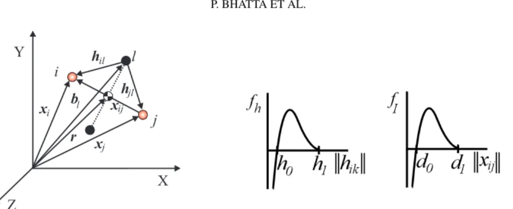
We model each vehicle in the group as a point mass with fully actuated dynamics. Let the position of theith vehicle in a group of N vehicles (with respect to the inertial frame) be given by a vectorxi ∈ R3,i = 1, . . . , N as shown in Figure 1. The control force on the
ith vehicle is given by ui∈ R3. The dynamics arex¨i= ui.
To control the formation, we introduce a web of M reference points called virtual
leaders. The position of thelth virtual leader with respect to the inertial frame is referred to asbl∈ R3, forl = 1, . . . , M and we assume that the virtual leaders are linked (i.e., they
form a virtual body). The position vector from the origin of the inertial frame to the center of mass of the virtual body is denoted byr ∈ R3
, as shown in Figure 1.
Letxij = xi− xj ∈ R3 andhil = xi− bl ∈ R3. Between every pair of vehiclesi
andj we define an artificial potential VI(xij). This interaction potential depends on the
distance between theith and jth vehicles. Similarly, between every vehicle i and every virtual leaderl we define an artificial potential Vh(hil), called the homing potential, which
depends on the distance between theith vehicle and the lth virtual leader.
The control law is defined as the negative of the gradient of the sum of these potentials plus a linear damping term [10]. The potential VI yields a force that is repelling when a
pair of vehicles is too close (kxijk < d0), attracting when the vehicles are too far (kxijk >
d0) and zero when the vehicles are very far apart (kxijk ≥ d1 > d0) or when they are
correctly spaced (kxijk = d0), whered0 andd1 are adaptable design parameters. The
potentialVh follows the same rules but we substituteh0andh1for, respectively,d0and
d1, as these design parameters can be different in each function (see Figure 2). 2.2 Formation Motion
The motion of the formation is controlled by prescribing the dynamics of the virtual body. The potentialVhforces the vehicles to follow the motion of the virtual body and the
po-tentialVImaintains the vehicles in formation.
One of the strengths of the VBAP methodology is the decoupling of the formation control problem into formation maintenance and maneuver management problems [9]. This permits the design and analysis of complex network behaviors. The decoupling is achieved by parameterizing the virtual body motion by a scalar variables, which describes the distance travelled by the virtual body. Using this parametrization we can describe the motion of the virtual body by a rotation matrixR(s) representing the orientation of the
P. BHATTA ET AL. i j xi xj r b l xij hil jl h X Y l Z
Figure 1. Vehicles (shaded circles) and virtual bodies (solid circles).
Figure 2. Representative control forces derived from artificial potentials.
virtual body and a vectorr(s) the position of the center of mass of the virtual body, i.e., by(R(s), r(s)) ∈ SE(3). The design problem is therefore reduced to the selection of the dynamicsdr/dt = (dr/ds)(ds/dt) and dR/dt = (dR/ds)(ds/dt) in order to accomplish the group mission.
The virtual body speed along its path,ds/dt, is chosen as a feedback of the formation error to guarantee stability and convergence of the formation. The virtual body slows down if the formation error (defined as the sum of all the interaction and homing potentials) grows too large and maintains a desired nominal speed when the formation error is small enough.
The remaining degrees of freedom in selecting the heading of the virtual body, i.e., dr/ds, dR/ds, are assigned to satisfy the mission objectives of the group. One possible objective for the formation is to follow the gradient of a particular field (e.g., temperature, salinity). Such a formation can locate absolute maxima of the field or alternate gradient climbing and descent to sample fronts (lines of high variability). In order to achieve gradi-ent climbing, a least-squares estimation of the gradigradi-ent is computed using noisy measure-ments from the vehicle array. The quality of the gradient estimate is enhanced by the use of a Kalman filter that also takes the time history of the measurements into account. The size of the formation can then be adjusted based on the variance of measurement noise to achieve the best possible formation for estimating the gradient using a given number of ve-hicles. The virtual body moves along the estimated gradient direction so that the formation proceeds towards the maximum of the scalar field. Details regarding gradient estimation and convergence properties of the group to the field extrema can be found in [10].
3
Formation Control of Underwater Glider Network During AOSN-II
The VBAP framework presented in the previous section assumes that all the vehicles are fully actuated and that there is continuous communication between all the vehicles. The framework was adapted in [11] to accommodate operational details specific to the under-water gliders used during the AOSN-II experiment. For example the modified control laws take into account constant speed constraints, external currents and intermittent glider com-munication. In this section we discuss the capabilities of underwater gliders and the results from the AOSN-II demonstration of coordinated control.
3.1 Underwater Gliders
Underwater gliders are energy efficient AUVs designed for continuous long-term deploy-ment. Typical underwater gliders developed and employed for scientific research include the Slocum [12], the Spray [13] and the Seaglider [14]. The energy efficiency of the gliders is due in part to the use of a buoyancy engine as opposed to a standard propeller for propulsion. The gliders change their net buoyancy to induce motion in the vertical direc-tion. In addition, they have fixed wings that provide lift and they redistribute their mass to control their attitude. The nominal motion of the glider is a combination of steady upward and downward glides at constant speed. These steady glides are inherently stable [15] and thus the nominal motion requires minimal active control. The glider heading is controlled using a rudder or by active roll control using internal mass redistribution. The Slocum gliders that implemented the VBAP framework during the AOSN-II experiment moved at a horizontal speed of about 40 cm/s and a vertical speed of about 20 cm/s relative to wa-ter. They established communication with a central command station when they surfaced, roughly every couple of hours. More details regarding glider operation during AOSN-II can be found in [16].
3.2 AOSN-II Coordinated Control Demonstration
We summarize one of the multi-asset demonstrations conducted during the AOSN-II ex-periment in this subsection. A more exhaustive exposition of these demonstrations can be found in [16].
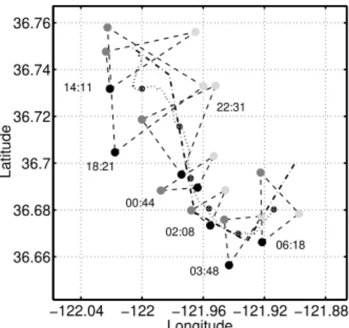
On August 16, 2003, a formation of three Slocum gliders was operated in a region simultaneously sampled by a ship dragging a towfish sensor array and a propeller driven AUV operated by MBARI, the Dorado. The objective was to use the towfish and Do-rado measurements to provide an independent data set by which to corroborate the glider formation’s sampling abilities.
In this mission the virtual body consisted of a single virtual leader, i.e., a single, moving reference point with a prescribed path. The prescribed piecewise-linear path is indicated by a dash-dotted line in Figure 3. The orientation of the triangle formed by the three vehicles was controlled such that one of the triangle edges was normal to the virtual body path. The desired inter-vehicle distance was initially set to 6 km and later reduced to 3 km (see Figure 4).
Figure 3 also shows the instantaneous glider formations during the demonstration. Starting from their initial distribution, the gliders expand to the desired spacing and orien-tation while the group centroid attempts to track the desired reference trajectory. Figure 4 shows the average vehicle distance over time in comparison to the commanded vehicle spacing. Formation control was achieved with decent accuracy despite periods of strong currents (at times greater than 30 cm/s) and numerous operational constraints during the demonstration.
4
Synoptic Area Coverage
In this section we summarize efforts in [17, 18, 19] toward developing multi-vehicle sam-pling control methods that provide synoptic domain coverage. We optimize the array of vehicles to maximize the mapping skill. Mapping skill is quantified using a sampling
met-P. BHATTA ET AL. −122.04 −122 −121.96 −121.92 −121.88 36.66 36.68 36.7 36.72 36.74 36.76 Longitude Latitude 14:11 18:21 22:31 00:44 02:08 03:48 06:18
Figure 3. Triangle formation snapshots at var-ious UTC times on August 16, 2003. Dotted line: path of formation centroid; Piecewise lin-ear dash-dotted line: desired virtual leader path.
227.6 227.8 228 228.2 228.4 228.6 2 3 4 5 6
Time (days into year 2003)
Average vehicle spacing
Actual Desired
Figure 4. The actual average of vehicle dis-tances during the demonstration and the desired vehicle spacing as a function of time from the August 16, 2003 demonstration.
ric derived from Objective Analysis [20, 21], a linear data assimilation scheme. In this framework, the scalar field (e.g., temperature or salinity) observed at each point r at each timet is viewed as a random variable T (r, t) i.e., an ensemble of possible realizations. The objective analysis algorithm keeps track of an estimate for the average of the ensemble and its second moment with respect to an a-priori estimate of the state (the background state). New measurements are assimilated by minimizing the least squares uncertainty of the new estimate (the analysis) ofT over the region of interest.
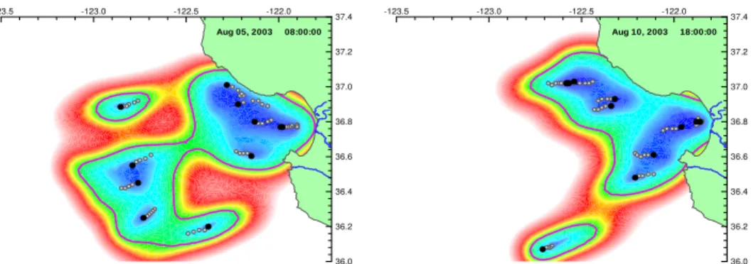
The sampling metric (i.e., the mapping skill) is defined as the integral over space and time of the analysis error covariance distributions. It is a measure of the uncertainty in the new state estimate; hence, it is desirable to optimize the sampling paths by minimizing this metric. Figure 5 shows snapshots of the a-posteriori (i.e., after data assimilation) covariance distributions at different times during the AOSN-II experiment. Data collected by both the Slocum and Spray gliders were used to establish the temporal and spatial scales [22] which parameterize the error maps [17].
Near-optimal sampling trajectories for synoptic coverage are obtained by limiting the possible vehicle tracks to simple, parameterized paths (e.g., ellipses, rectangles) and op-timizing over the parameters. The optimization of the sampling metric for near-optimal trajectories is a much more tractable problem than an exhaustive search for the absolute minima. Moreover, by restricting the choice of network trajectory collectives to a specific geometry, experimental constraints are easier to implement and the data collected along the paths can be more easily interpreted and compared with historical oceanographic sections. The coordinated motion of the sensor network on near-optimal closed tracks can be parameterized by a relatively small number of parameters – the number of tracks, the number of vehicles on each track, the position, size and shape of each track, as well as the relative position of each pair of vehicles as they move around their tracks.
In [17, 18], feedback control laws are designed that stabilize collective motion of a pla-nar model of autonomous vehicles moving at a constant speed on circles. Ongoing work extends these results to ellipses and other kinds of tracks suitable for specific applications.
-123.5 -123.0 -122.5 -122.0 36.0 36.2 36.4 36.6 36.8 37.0 37.2 37.4 Aug 05, 2003 08:00:00 -123.5 -123.0 -122.5 -122.0 36.0 36.2 36.4 36.6 36.8 37.0 37.2 37.4 Aug 10, 2003 18:00:00
Figure 5. Error map at different times during the AOSN 2003 experiment. Blue represents small error (good coverage) and red and white represents high error (poor coverage). The spatial scale (25km) and the temporal scale (2.5days) are estimated in [22].
All vehicles are considered to be identical and equipped with steering control. One compo-nent of the feedback control stabilizes the circular motion of the group of vehicles about its center of mass. This component depends on the relative position of the vehicles. Another component of the feedback control law depends only on the relative phases of the vehicles, which, for circular motion, is equivalent to relative headings of the vehicles. This latter component stabilizes symmetric patterns of the vehicles in the circular formation.
If the feedback control law is a function only of relative positions and headings of vehicles, the system is invariant to rigid rotation and translation in the plane, i.e., the control law does not prevent the collective of vehicles to move around the plane as a rigid body. Such a symmetry with respect to rigid rotation and translation is often useful, especially when the control authority is limited. On the other hand, breaking this symmetry can lead to useful variations on circular formations. For example, by introducing a fixed beacon we can break the symmetry with respect to translation. The symmetry with respect to rotation is broken by introducing a reference angle. Furthermore we can introduce block all-to-all interconnection topologies for the spacing and orientation coupling in order to stabilize collective motion of subgroups of vehicles. This includes the case in which there are multiple circles with a different subgroup of vehicles moving around each circle.
Convergence results regarding stabilization to various possible circular formations as well as to formations of vehicles translating along straight, parallel trajectories are pre-sented in [18]. These results are also used to define behavior primitives for switching between the stable, steady formation motions to enable the group to track piecewise-linear trajectories with fixed waypoints. Figure 6 illustrates a simulation of a network of 12 ve-hicles stabilizing to circular motion with uniform spacing. Figure 7 shows a simulation of the network tracking a reference trajectory using a behavior sequence constructed out of a set of primitives. In both simulations the vehicles start with random initial conditions.
A control law is described in [17] to stabilize a single vehicle on an elliptical trajectory about a fixed beacon. Vehicles on separate ellipses are coupled using their relative headings in order to synchronize the vehicle phases about each ellipse.
The small number of parameters renders the problem of optimizing the Objective Ana-lysis metric tractable. It is possible to reduce the number of parameters even more using dimensional analysis [17]. Numerical optimization experiments for a single vehicle on an elliptical trajectory and for a pair of vehicles on separate ellipses are described in [17].
P. BHATTA ET AL. −20 −10 0 10 20 −25 −20 −15 −10 −5 0 5 10 15 x y
Figure 6. Result of a numerical simulation of 12 vehicles, stabilizing to a circular formation with uniform spacing. The arrows indicate the instan-taneous velocity of each vehicle.
0 100 200 300 400 500 −300 −250 −200 −150 −100 −50 0 50 100 150 x y A B C D E
Figure 7. Tracking a piecewise-linear curve with 12 vehicles, using a behavior sequence con-structed from circular and parallel motion primi-tives.
5
Conclusions and Future Directions
We have discussed feedback control strategies for sampling the ocean at various spatial and temporal scales using AUVs. The VBAP framework for formation control was im-plemented on a fleet of underwater gliders during the AOSN-II experiment. We intend to implement a framework for steering the gliders along optimal, coordinated trajectories during the upcoming ASAP experiment in August 2006.
Implementing formation control strategies on groups of AUVs is challenging due to the limited control and communication capabilities. The control framework must be robust with respect to ocean currents, time delays in control implementation and asynchronous communications.
Several avenues of further research can provide useful tools toward further enhanc-ing ocean samplenhanc-ing capabilities. For example, predictenhanc-ing and utilizenhanc-ing Lagrangian Coher-ent Structures (LCS) [23, 24] may prove useful in improving the range of travel of AUV groups [25, 26]. Dynamic front tracking algorithms [27] may also yield valuable data related to various ecological phenomena in the ocean.
References
1. Shulman I., Wu C. R., Lewis J. K., Paduan J. C., Rosenfeld L. K., Kindle J. C., Ramp S. R. and Collins C. A., High resolution modeling and data assimilation in the Monterey Bay area.
Continental Shelf Research 22(8), 1129–1151 (2002).
2. Lermusiaux P. F. J. and Robinson A. R., Data assimilation via error subspace statistical estima-tion. Part I: Theory and schemes. Monthly Weather Review 127 (7), 1385–1407 (1999). 3. Lermusiaux P. F. J., Anderson D. G. M. and Lozano C. J., On the mapping of multivariate
geophysical fields: Error and variability subspace estimates. Quarterly Journal of the Royal
Meteorological Society 126(565), 1387–1429 (2000).
4. Uci´nski D., Optimal measurement methods for distributed parameter system identification. Boca Raton, FL, 33–102 (2005).
5. Autonomous Ocean Sampling Network, MBARI website http://www.mbari.org/aosn (2003). 6. Okubo A., Dynamical aspects of animal grouping: Swarms, schools, flocks and herds.
Ad-vances in Biophysics 22, 1–94 (1986).
pattern, and evolutionary trade-offs in animal aggregation. Science 284, 99–101 (1999). 8. Leonard N. E. and Fiorelli E., Virtual leaders, artificial potentials and coordinated control of
groups. Proc. 40th IEEE Conf. Decision and Control, 2968–2973 (2001).
9. ¨Ogren P., Fiorelli E. and Leonard N. E., Formations with a mission: Stable coordination of vehicle group maneuvers. Proc. Symposium of Mathematical Theory of Networks and
Systems(2002).
10. ¨Ogren P., Fiorelli E. and Leonard N. E., Cooperative control of mobile sensor networks: Adap-tive gradient climbing in a distributed environment. IEEE Transactions on Automatic
Con-trol 49(8), 1292–1302 (2004).
11. Fiorelli E., Bhatta P., Leonard N. E. and Shulman I., Adaptive sampling using feedback control of an autonomous underwater glider fleet. Proc. Symposium on Unmanned Untethered
Submersible Technology(2003).
12. Webb D. C., Simonetti P. J. and Jones C. P., SLOCUM: An underwater glider propelled by environmental energy. IEEE Journal of Oceanic Engineering 26 (4), 447–452 (2001). 13. Sherman J., and Davis R. E., Owens W. B. and Valdes J., The autonomous underwater glider
“Spray”. IEEE Journal of Oceanic Engineering 26, 437–446 (2001).
14. Eriksen C. C., Osse T. J., Light R. D., Wen T., Lehmann T. W., Sabin P. L., Ballard J. W. and Chiodi A. M., Seaglider: A long range autonomous underwater vehicle for oceanographic research. IEEE Journal of Oceanic Engineering 26 (4), 424–436 (2001).
15. Bhatta P. and Leonard N. E., A Lyapunov function for vehicles with lift and drag: Stability of gliding. Proc. 43rd IEEE Conf. on Decision and Control 4101–4106 (2004).
16. Fiorelli E., Leonard N. E., Bhatta P., Paley D., Bachmayer R. and Fratantoni D. M., Multi-AUV control and adaptive sampling in Monterey Bay. Proc. IEEE AUV 2004: Workshop on
multiple AUV operations(2004).
17. Leonard N. E., Paley D., Lekien F., Sepulchre R. and Fratantoni D. M., Collective motion, sensor networks and ocean sampling. Proc. IEEE Special Issue on Networked Control
SystemsSubmitted (2005).
18. Sepulchre R., Paley D. and Leonard N. E., Stabilization of planar collective motion, part I: All-to-all communication. IEEE Transactions on Automatic Control Submitted (2005). 19. Paley D., Leonard N. E. and Sepulchre R., Oscillator models and collective motion: Splay
state stabilization of self-propelled particles. Proc. 44th IEEE Conf. on Decision and
Control(2005).
20. Gandin L., Objective analysis of meteorological fields. Translated from Russian by R. Hardin, Israel Program for Scientific Translations, Jerusalem (1963).
21. Bretherton F. P., Davis R. E. and Fandry C. B., A technique for objective analysis and design of oceanographic experiments applied to MODE-73. Deep Sea Research 23, 559–582 (1976). 22. Rudnick D. L., Davis R. E., Eriksen C. C., Fratantoni D. M. and Perry M. J., Underwater Gliders
for Ocean Research. Marine Technology Society Journal, 38 (1), 48–59 (2004).
23. Haller, G. and Yuan, G., Lagrangian coherent structures and mixing in two-dimensional turbu-lence, Physica D, 147 (3-4), 352–370 (2000).
24. Shadden, S. C., Lekien, F. and Marsden, J. E., Definition and properties of Lagrangian co-herent structures from finite-time Lyapunov exponents in two-dimensional aperiodic flows.
Physica D, Submitted (2005).
25. Inanc T., Shadden S. C. and Marsden J. E., Optimal trajectory generation in ocean flows. In
Proc. American Control Conf.674–679 (2004).
26. Lekien, F., Coulliette, C., Mariano, A. J., Ryan, E. H., Shay, L. K., Haller, G. and Marsden, J. E., Pollution release tied to invariant manifolds: A case study for the coast of Florida. Physica
D, 210 (1-2), 1–20 (2005).
27. Zhang, F and Leonard N. E., Generating contour plots using multiple sensor platforms. Proc.