HAL Id: hal-02180968
https://hal.archives-ouvertes.fr/hal-02180968
Submitted on 11 Jul 2019
HAL is a multi-disciplinary open access archive for the deposit and dissemination of sci-entific research documents, whether they are pub-lished or not. The documents may come from teaching and research institutions in France or abroad, or from public or private research centers.
L’archive ouverte pluridisciplinaire HAL, est destinée au dépôt et à la diffusion de documents scientifiques de niveau recherche, publiés ou non, émanant des établissements d’enseignement et de recherche français ou étrangers, des laboratoires publics ou privés.
Distribution of major elements in Atlantic surface
sediments (36°N-49°S): Imprint of terrigenous input and
continental weathering
Aline Govin, Ulrike Holzwarth, David Heslop, Lara Ford Keeling, Matthias
Zabel, Stefan Mulitza, James Collins, Cristiano Chiessi, Lara Keeling
To cite this version:
Aline Govin, Ulrike Holzwarth, David Heslop, Lara Ford Keeling, Matthias Zabel, et al.. Distribution of major elements in Atlantic surface sediments (36°N-49°S): Imprint of terrigenous input and conti-nental weathering. Geochemistry, Geophysics, Geosystems, AGU and the Geochemical Society, 2012, 13 (1), pp.n/a-n/a. �10.1029/2011GC003785�. �hal-02180968�
ISSN: 1525-2027
Distribution of major elements in Atlantic surface sediments
(36°N–49°S): Imprint of terrigenous input and continental
weathering
Aline Govin and Ulrike Holzwarth
MARUM–Center for Marine Environmental Sciences, University of Bremen, Leobener Strasse, D-28359 Bremen, Germany (aline.govin@uni-bremen.de)
David Heslop
Research School of Earth Sciences, Australian National University, Canberra, ACT 0200, Australia
Lara Ford Keeling
Texas A&M University–Corpus Christi, Corpus Christi, Texas 78412, USA
Matthias Zabel, Stefan Mulitza, and James A. Collins
MARUM–Center for Marine Environmental Sciences, University of Bremen, Leobener Strasse, D-28359 Bremen, Germany
Cristiano M. Chiessi
School of Arts, Sciences and Humanities, University of São Paulo, São Paulo 12227–010, Brazil
[1] Numerous studies use major element concentrations measured on continental margin sediments to
reconstruct terrestrial climate variations. The choice and interpretation of climate proxies however differ from site to site. Here we map the concentrations of major elements (Ca, Fe, Al, Si, Ti, K) in Atlantic surface sediments (36°N–49°S) to assess the factors influencing the geochemistry of Atlantic hemipelagic sediments and the potential of elemental ratios to reconstruct different terrestrial climate regimes. High concentrations of terrigenous elements and low Ca concentrations along the African and South American margins reflect the dominance of terrigenous input in these regions. Single element concentrations and elemental ratios including Ca (e.g., Fe/Ca) are too sensitive to dilution effects (enhanced biological produc-tivity, carbonate dissolution) to allow reliable reconstructions of terrestrial climate. Other elemental ratios reflect the composition of terrigenous material and mirror the climatic conditions within the continental catchment areas. The Atlantic distribution of Ti/Al supports its use as a proxy for eolian versus fluvial input in regions of dust deposition that are not affected by the input of mafic rock material. The spatial distribu-tions of Al/Si and Fe/K reflect the relative input of intensively weathered material from humid regions versus slightly weathered particles from drier areas. High biogenic opal input however influences the Al/Si ratio. Fe/K is sensitive to the input of mafic material and the topography of Andean river drainage basins. Both ratios are suitable to reconstruct African and South American climatic zones characterized by different intensities of chemical weathering in well-understood environmental settings.
Components: 14,700 words, 5 figures, 3 tables.
Keywords: Atlantic surface sediments; terrigenous input; major elements.
Index Terms: 1051 Geochemistry: Sedimentary geochemistry; 1065 Geochemistry: Major and trace element geochemistry; 4924 Paleoceanography: Geochemical tracers.
Received 8 July 2011; Revised 4 October 2011; Accepted 11 December 2011; Published 20 January 2012.
Govin, A., U. Holzwarth, D. Heslop, L. Ford Keeling, M. Zabel, S. Mulitza, J. A. Collins, and C. M. Chiessi (2012), Distribution of major elements in Atlantic surface sediments (36°N–49°S): Imprint of terrigenous input and continental weathering, Geochem. Geophys. Geosyst., 13, Q01013, doi:10.1029/2011GC003785.
1. Introduction
[2] Terrigenous materials are transported into the
oceans via fluvial and eolian pathways, which are both sensitive to climate changes [e.g., Milliman and Meade, 1983; Miller and Russell, 1992; Rea, 1994]. While changes in aridity, wind strength and direction modify the magnitude and composi-tion of eolian input [e.g., Rea, 1994; Engelstaedter et al., 2006], variations in sea level [Milliman et al., 1975] and continental precipitation [Milliman and Meade, 1983; Milliman and Syvitski, 1992] alter the amount and path of fluvial sediments transported into the ocean.
[3] The Atlantic Ocean receives a significant amount
of terrigenous material from the African and South American continents, of eolian [e.g., Engelstaedter et al., 2006] and fluvial [e.g., Peucker-Ehrenbrink, 2009] origins. Several approaches have been applied to marine sediment cores to reconstruct past varia-tions in terrigenous supply into the Atlantic. They are based on (1) the carbonate and opal-free ter-rigenous fraction [e.g., Ruddiman and Janecek, 1989; deMenocal et al., 1993; Tiedemann et al., 1994; deMenocal et al., 2000], (2) grain-size anal-yses [e.g., Sarnthein et al., 1981; Rea, 1994; Ratmeyer et al., 1999; Stuut et al., 2002; Holz et al., 2004; Mulitza et al., 2010], (3) reflectance [e.g., Balsam et al., 1995; Heslop et al., 2007; Itambi et al., 2009], (4) magnetic techniques [e.g., Bloemendal et al., 1992; Frederichs et al., 1999; Evans and Heller, 2003; Itambi et al., 2009], and (5) the distribution of clay minerals [e.g., Petschick et al., 1996]. Additionally, a growing number of studies use the major element composition of marine sediment cores to trace changes in terrige-nous input into the Atlantic [e.g., Arz et al., 1999; Peterson et al., 2000; Yarincik et al., 2000; Haug et al., 2001; Zabel et al., 2001; Adegbie et al., 2003; Jaeschke et al., 2007; Mulitza et al., 2008; Tisserand et al., 2009]. This effort results from the recent development of X-ray fluorescence (XRF) core scanners that can obtain nondestructive, almost continuous and relatively fast measurements of the intensities of major elements directly at the surface of sediment cores.
[4] Numerous major-element based proxies have
been developed and used to reconstruct terrestrial paleoclimate with partly controversial interpreta-tions. The intensities (or number of counts) of ter-restrial single elements have been used to trace the supply of terrestrial material to the ocean. For example, increased intensities of iron (Fe) and tita-nium (Ti) were interpreted as increased supplies of siliciclastic material of fluvial origin in the Cariaco Basin [Peterson et al., 2000; Haug et al., 2001] and at the mouth of the Plata River [Chiessi et al., 2009]. Bozzano et al. [2002] however used increased pro-portions of Fe as a proxy for high Saharan and Sahelian dust deposition in sediments off Morocco. In nearby sites, Kuhlmann et al. [2004a] used high intensities of potassium (K) as an indicator of Mor-occan fluvial input that reflects humid terrestrial conditions. Conversely, Mulitza et al. [2008] inter-preted increased proportions of K off Senegal as increased eolian input to the ocean reflecting dry terrestrial conditions. The choice and climatic inter-pretation of single elements hence differ from site to site. In addition, dilution processes such as changes in marine biological productivity [e.g., Bozzano et al., 2002] affect the interpretation of single ele-ment concentrations (see section 4.1).
[5] Insensitive to dilution effects, elemental ratios
are more useful than single elements [e.g., Weltje and Tjallingii, 2008]. Among existing ratios, iron/ calcium (Fe/Ca), titanium/calcium (Ti/Ca), titanium/ aluminum (Ti/Al), iron/potassium (Fe/K) and aluminum/silicon (Al/Si) are the most commonly used for paleoclimate reconstructions. Fe and Ti are related to the siliciclastic components of the sediment and vary with the terrigenous fraction of the sediment [e.g., Arz et al., 1998; Jansen et al., 1998], whereas Ca often represents the carbonate content of the sediment [Peterson et al., 2000; Bozzano et al., 2002]. The Fe/Ca and Ti/Ca ratios have hence been used to trace changes in terrige-nous input of mainly fluvial origin, particularly offshore Northeastern Brazil [Arz et al., 1998, 1999; Jaeschke et al., 2007] and Western Africa [Adegbie et al., 2003; Pierau et al., 2010].
[6] In marine sediments, the coarse sediment
frac-tions are enriched in Ti [e.g., Schütz and Rahn,
Geochemistry Geophysics
1982; Shiller, 1982], while Al is mostly associated with fine-particle clay minerals [Biscaye, 1965]. A number of studies from the tropical Atlantic [Boyle, 1983; Zabel et al., 1999; Yarincik et al., 2000; Jullien et al., 2007; Tisserand et al., 2009] inter-preted past Ti/Al changes to represent grain size variations, and hence fluctuations in trade wind intensity and eolian supply. Similarly, the Ti/Al variability was also understood in terms of the rel-ative contribution of eolian versus fluvial input in the eastern Mediterranean Sea [Lourens et al., 2001] and off Senegal [Itambi et al., 2009]. [7] In tropical humid regions, high precipitation
promotes intense chemical weathering of bedrocks (e.g., continental shields and tropical alluvial plains) [Middelburg et al., 1988; Driessen et al., 2001]. This results in the presence of highly weathered soils whose geochemical signature rich in Fe [Driessen et al., 2001] is transferred to marine sediments by fluvial input. In marine sediments, K derives from potassium feldspar [Zabel et al., 2001] or illite [Yarincik et al., 2000], which are both character-istic of drier regions with low chemical weathering rates [Zabel et al., 2001]. Mulitza et al. [2008] used the Fe/K ratio as a proxy for fluvial versus eolian input off Senegal, where high Fe/K values indicate an increased supply of Senegal River suspended material relative to dust deposition. [8] In marine sediments, Si is contained in all clay
minerals, in particular in quartz grains [Moore and Dennen, 1970]. Al is mostly associated in the sedi-ment with fine-grained clay minerals [Biscaye, 1965], in particular with kaolinite, which is a prod-uct of intensive chemical weathering under wet conditions [Bonatti and Gartner, 1973]. Studies off Senegal [Itambi et al., 2009], Mauritania [Tisserand et al., 2009] and in the North Canary basin [Moreno et al., 2001] interpreted Si/Al variations as changes in terrigenous quartz input related to wind strength fluctuations. In addition, Chiessi et al. [2010] used the Al/Si ratio as a proxy for the inten-sity of continental chemical weathering within the Plata River drainage basin. Similarly, Mulitza et al. [2008] showed a high correlation between the amount of fine material and the Al/Si ratio. They interpreted high Al/Si values as increased river sus-pension input relative to dust deposition in sediments off Senegal.
[9] The above examples illustrate the variety of
cli-mate indicators derived from major element con-centrations (Fe, Ti, K) and ratios (Fe/Ca, Ti/Ca, Ti/Al, Fe/K, Al/Si) measured in marine sediments. Here we present bulk elemental compositions of a
collection of 128 Atlantic surface sediment sam-ples (36°N–49°S) that are influenced by a wide variety of continental climatic regimes and of source rocks and soils. The objectives of our study are twofold. First, we aim to elucidate the influ-ence of terrigenous input on the geochemical com-position of tropical and subtropical Atlantic surface sediments. We hence discuss the processes influ-encing the spatial distribution of major elements (Ca, Fe, Al, Si, Ti, K) in Atlantic surface sediments. Second, we assess the potential of elemental ratios (Fe/Ca, Ti/Ca, Ti/Al, Al/Si, Fe/K), commonly obtained from XRF core scanners as part of paleo-climate studies, to reconstruct changes in terrestrial climate conditions over Africa and South America.
2. Material and Methods
2.1. Environmental Setting
[10] The Atlantic Ocean is the Earth’s oceanic basin
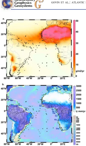
receiving the highest dust deposition flux, account-ing for up to 70% of the global oceanic budget [Engelstaedter et al., 2006]. Dust particles deposited into the Atlantic Ocean (south of 40°N) originate from three main arid regions (the Sahara-Sahel, Namibia-Botswana and Patagonia-Argentinean Pam-pas) [Prospero et al., 2002; Mahowald et al., 2005] (Figure 1). The Sahara and Sahel in northern Africa constitute by far the most prominent source of dust [Prospero et al., 2002] (Figure 1a). Dust particles are mainly produced in the Bodélé depression in Chad and the Mauritania-Mali region [Middleton and Goudie, 2001; Engelstaedter et al., 2006]. They are transported westward, both at high altitudes (5–6 km) during boreal summer [Caquineau et al., 2002; Engelstaedter et al., 2006] by the Saharan Air Layer across the North Atlantic [Prospero, 1996] toward South America and the Caribbean Sea [Prospero et al., 1981], and at lower altitudes (1.5–3 km) during boreal winter-spring [Orange and Gac, 1990; Caquineau et al., 2002] by the northeast trade winds along the northwest African margin [Chiapello et al., 1997; Caquineau et al., 2002]. To a lesser extent, dust is produced in the arid regions of Namibia and Botswana in southern Africa, with maximum dust emissions between June and October [Prospero et al., 2002; Bryant, 2003]. Southern African dust particles are carried northwestward by the southeast trade winds and deposited at relatively short distances along the Namibian and Angolan margins [Prospero et al., 2002] (Figure 1a). In South America, dust is pro-duced in Patagonia and the Argentinean Pampas and is transported eastward by the westerly winds,
before settling into the South Atlantic south of 35°S [Prospero et al., 2002] (Figure 1a).
[11] The main African and South American rivers
(Figure 1b) rank among the world’s largest [Milliman and Meade, 1983; Milliman and Syvitski, 1992; Peucker-Ehrenbrink, 2009]. Rivers with the highest runoff (i.e., the Amazon, Orinoco and Plata Rivers in South America; the Congo, Niger and Ogooue Rivers in Africa, Table 1) receive the highest amount of precipitation over their drainage basins [e.g., Miller and Russell, 1992; Milliman and Syvitski, 1992] (Figure 1b). The spatial distri-bution of precipitation is the primary factor con-trolling water discharge [Milliman et al., 2008]. The size and topography of the drainage basin primarily control the sediment discharges of most rivers, while net precipitation and runoff play a secondary role [Milliman and Syvitski, 1992]. For example, the Orange River exhibits one of the highest sediment discharge values among the major African rivers, while its runoff remains very low (Table 1).
[12] The fate of riverine waters after their
dis-charge in the coastal ocean has been investigated for some African and South American rivers. The development of a freshwater plume in the ocean does not only depend on the magnitude of the river discharge, but also on the direction and magnitude of the wind stress forcing [Kourafalou et al., 1996]. For example, the southeast trade
Table 1. Drainage Basin Area, Annual Water Discharge and Annual Suspended Sediment Flux of the Main African and South American Riversa
River Drainage Basin Area (km2) Annual Water Discharge (km3/yr) Annual Suspended Sediment Flux (106t/yr) Africa Senegal 353,000 21.9 2.2 Gambia 71,095 4.6 0.1 Niger 2,120,000 192.1 39.8 Sanaga 129,606 64.8 5.8 Ogooue 223,000 149.5 Congo 3,710,000 1283.0 32.8 Kunene 108,250 6.8 0.4 Orange 945,000 11.4 88.8 South America Orinoco 953,598 1100 173.2 Amazon 6,133,120 6300 1193.4 São Francisco 618,906 96 6.2 Plata 2,722,196 463.8 89.5
aFrom North To South. Values are the best estimates (usually the
median of individual estimates) extracted from the recent compilation by Peucker-Ehrenbrink [2009].
Figure 1. Sample locations. The black dots indicate the surface sediment samples located above the lysocline, while the white dots show the samples situated below the lysocline. (a) The dust deposition data (red scale) from Mahowald et al. [2005] show the extent of the dust plumes (red areas) originating from Northwestern Africa, Namibia and Patagonia. Country names men-tioned in the text are indicated with gray letters fol-lowing the ISO 3166 standard (AGO, Angola; ARG, Argentina; BRA, Brazil; BWA, Botswana; CIV, Ivory Coast; COD Democratic Republic of the Congo (Zaire); CMR, Cameroon; GIN, Guinea; GUY, Guyana; MAR, Morocco; MLI, Mali; MRT, Mauritania; NAM, Namibia; PRY, Paraguay; SEN, Senegal; TCD, Chad; URY, Uruguay). (b) The bathymetry (pastel scale in lower right corner) highlights the position of the mid-Atlantic ridge. Over the continents, the mean annual (1950– 1999) terrestrial precipitation from the University of Delaware (http://climate.geog.udel.edu/!climate/) (blue scale in upper right corner), the major rivers (black line) and rivers of intermediate importance (gray line) are shown. Dark blue letters and arrows refer to the name and mouth of the main African Rivers (Se, Senegal; Ga, Gambia; Ni, Niger; Sa, Sanaga; Og, Ogooue; Co, Congo; Ku, Kunene; Ora, Orange) and South American Rivers (Ori, Orinoco; Am, Amazon; SF, São Francisco; Pl, Plata). The maps were generated with the Ocean Data View software [Schlitzer, 2010].
Geochemistry Geophysics
winds push the large plume of the Congo River offshore toward the north-northwest, forming a thin, low salinity surface layer [Eisma et al., 1978]. Similarly, anomalously strong northeasterly winds blowing along the South American coast during El Niño conditions counteract the increased runoff of the Plata River induced by higher rainfall in the drainage basin and limit the northward pene-tration of the river plume along the Brazilian shelf observed under La Niña conditions [Piola et al., 2005]. Off northern South America, most waters from the Amazon and Orinoco Rivers are directed northwestward toward the Caribbean Sea by the northeast trade winds [Eisma et al., 1991; Hu et al., 2004]. A significant part of the Amazon River plume is however deflected eastward into the North Equatorial Counter Current, in particular during Northern Hemisphere autumns (July–October) [Muller-Karger et al., 1988, 1995; Hu et al., 2004].
[13] Figure 2 shows the distribution of the major
soil types in Africa and South America, the
immediate sources for the terrigenous input to the Atlantic. Highly weathered soils, such as Acrisols, Plinthosols and Ferralsols (Table 2) (see Driessen et al. [2001] for a detailed description of the soil types), are predominantly observed in trop-ical African and South American regions (Figure 2) where annual rainfall is high (Figure 1b). In con-trast, slightly weathered soils (e.g., sand dunes, Arenosols, Cambisols, Leptosols, Phaeozems and Solonetz [Driessen et al., 2001]) (Table 2) are pres-ent at higher latitudes (Figure 2) in areas receiving less precipitation (Figure 1b). There is little infor-mation available on the geochemical composition of these different soil types. Intensively weathered soils are generally enriched in Fe and Al, whereas slightly weathered soils are relatively enriched in K and Si [Moore and Dennen, 1970; Middelburg et al., 1988; Driessen et al., 2001]. Relevant infor-mation on the elemental composition of eolian and fluvial material that originates from Africa and South America and deposits in the Atlantic is com-piled in Table S3.1
2.2. Material
[14] To assess the factors influencing the modern
geochemical composition of Atlantic sediments, we considered 128 sediment samples collected during 44 cruises of the German research vessels Meteor, Poseidon and Sonne over the last 25 years (Figure 1 and Table S1). We sampled the surface sediment of 3 giant box cores and 125 multicores. These devices limit the disturbance of surface sediments during the coring procedure. The sam-ples are distributed in the South Atlantic and the tropical Atlantic between 36°N and 49°S (Figure 1 and Table S1). About 75% of the samples are located along the African and South American continental margins and 25% on the mid-Atlantic ridge or in the Atlantic abyssal basins (Figure 1). The water-depth of the samples ranges from 100 m to 5584 m. Most of the sites are presently located above the modern lysocline, i.e., shallower than 3500 m along the South American margin south of 30°S and shallower than 4000 m elsewhere [Volbers and Henrich, 2004] (Figure 1). Twenty-seven sam-ples from the Atlantic abyssal basins are situated below the modern lysocline (Figure 1).
[15] We sampled the uppermost available sediment
layer (0–0.5 cm, 0.5–1 cm or 0–1 cm) of Figure 2. Major types of soils in Africa and South
America [FAO et al., 2009]. General soil characteristics are given in Table 2 (see Driessen et al. [2001] for a detailed description of the soil types). Intensively weathered soils (Acrisols, Plinthosols, Ferralsols) are observed in tropical humid areas, whereas slightly weathered soils (Sand dunes, Arenosols, Cambisols, Leptosols, Phaeozems, Solonetz) are present under drier conditions. The black dots indicate the samples located above the lysocline, while the white dots show the ones below the lysocline. Green numbers and shaded areas refer to specific geographic areas cited in the text: (1) Canary Islands, (2) Cape Blanc, (3) Mauritanian upwelling, (4) Sierra Leone Rise, (5) São Tomé island, (6) Santa Helena island, (7) Benguela upwelling, (8) Tristan da Cunha island, (9), Brazil-Malvinas Con-fluence, (10) Barbados islands and (11) the Cariaco Basin.
1Auxiliary materials are available in the HTML. doi:10.1029/
Table 2. General Characteristics of Major Mineral Soil Types Shown in Figure 2a
Soil Type Determined by aSoil Formation Typical Environments Main Distribution in Africaand South America WeatheringDegree of General Soil Composition Chemical Characteristics
Sand dunes Sandy parent material Active dunes Sahara, Sahel Very low “non-soils” (sandy material)
Arenosol Sandy parent material (Semi-) arid areas
Inland dunes Sahara, SahelCentral African plateau Very low Sandy soils rich in quartzand felspars Rich in basic ions(e.g., Na, Ca, Mg, K)
Cambisol Limited soil age Temperate and boreal regions
Active erosion Andes (eastern Argentina)Eastern Paraguay Moderate Brown soils at an early stageof formation Variable (presence ofweatherable minerals)
Leptosol Elevated and eroding
environment Mountain regions Saharan desertAndes Low Very thin soils with highlyvariable composition Highly variable
Phaeozem Steppic climate Wet steppe areas Subtropical Argentinean and
Uruguayan pampas Moderate Dark humus-rich soils High organic content
Solonetz (Semi-) arid climate Areas with hot and
dry summers Western ParaguayNorthern Argentina Low Dense clay natric (high proportionof adsorbed Na ions) soils High Na and Mg contents
Acrisol Wet (sub-) tropical
climate Humid acid rockerosional areas Southern Amazon BasinEastern (Ivory Coast) and western (Zaire) Africa
Intense Strongly weathered acidic soils
(rich in kaolinite) High Fe and Al contents
Plinthosol Wet (sub-) tropical
climate Rain forest areasSavannah zones Eastern Amazon BasinCentral Congo Basin Intense Iron-rich humus-poormixture of kaolinitic clay and quartz
High Fe and Al contents Ferralsol Wet (sub-) tropical
climate Continental shieldsAlluvial lowlands Brazilian, Zairian, Angolanand Guinean shields Amazon and Congo basins
Intense and deep Clay assemblage dominated by kaolinite and hydrated Fe- and Al-oxides
High Fe and Al contents
aSee Driessen et al. [2001] for detailed information. Country names are indicated in Figure 1a.
Geochemistry Geophysics Geosystems
G
3
G
3
GOVIN ET AL .: A T L A N T IC SU R F A C E S E D IM E N T C O M P O S IT IO N 10.1029/2011GC003785 6 of 23multicores, and used the 1–2 cm layer in only 13 samples (Table S1). Foraminiferal oxygen isotopic composition data and AMS 14C dating in parallel
piston, gravity cores and multicores [Kuhlmann et al., 2004b; Mollenhauer et al., 2004; Seiter et al., 2005; Chiessi et al., 2007] indicate a Holo-cene age for the used samples. Sedimentation rates are higher along the African coast and off the Northeastern Brazilian margin (sedimentation rate >5 cm/ka) than on the mid-Atlantic ridge or in the Atlantic abyssal basins (sedimentation rate down to 0.5 cm/ka) [Kuhlmann et al., 2004b; Mollenhauer et al., 2004; Seiter et al., 2005]. The 0.5 cm- or 1 cm-thick surface sediment samples taken in this study therefore comprise a varying time-span rang-ing from a few decades in areas of high sedimenta-tion to a maximum of 2000 years in regions with low sedimentation rates.
2.3. Measurement of Major Element Concentrations
[16] Sediment samples were stored at "20°C in the
Bremen Core Repository (BCR, Germany). At room temperature, we sampled 3 to 6 mL of sediment (corresponding to 0.5 to 5 g of dry sediment) with cut syringes for geochemical analyses. Samples were freeze-dried, and then powdered and homog-enized with an agate mortar. We chose to analyze the elemental concentrations of the bulk sediment rather than of the carbonate-free, opal-free and oxide-free fractions for one main reason. In order to assess the potential of elemental concentrations and ratios to reconstruct terrestrial climate zones, we wanted to measure the elemental composition of the sediment under similar conditions to the ones used by non-destructive XRF core scanning measurements, which are commonly applied in paleoclimate studies. Therefore we measured the concentration of major elements (Ca, Fe, Al, Si, Ti, K) of the bulk sediment samples by energy dis-persive polarization X-ray Fluorescence (EDP-XRF) spectroscopy, using a SPECTRO XEPOS instru-ment [Wien et al., 2005]. The device was operated with the software Spectro X-Lab Pro (Version 2.4), using the Turboquant method [Schramm and Heckel, 1998]. We assessed the analytical quality of the measurements by repeated analyses of the certified standard reference material MAG-1 [Govindaraju, 1994]. The measured values were within 1% of accepted values. The standard devi-ation of replicated sediment samples was less than 2%. The concentrations of major elements are expressed in grams per kilogram of dry sediment (g/kg). The concentration of K is below the
detection limit (0.08 g/kg) in seven samples from the mid-Atlantic ridge (Table S1).
2.4. Cluster Analysis
[17] To identify characteristic groups of coherent
elemental composition in Atlantic surface sedi-ments, we performed a fuzzy c-means cluster anal-ysis of the elemental data using the algorithm of Bezdek [1981]. We considered the concentrations of the five terrigenous elements Fe, Al, Si, Ti and K for the 96 samples located along the African and South American continental margins. The ele-mental data were pretreated using the centered log-ratio (clr) transform of Aitchison [1986] to map them from their simplicial sample space into a real space appropriate for cluster analysis [Martín et al., 1998]. The fuzzy clustering employed Euclidean distances between the transformed data points and was calculated with a fuzzy exponent of 1.5. Each sample was assigned a membership in the interval [0,1] to each of the cluster centers, where a value of 1 indicates that a sample is identical to a cluster center (the membership value will decrease as the similarity with the cluster center decreases). For any given sample the total memberships over all the cluster centers must sum to unity. After the assignment of the memberships, the positions of the cluster centers were converted back to the original compositional data space using the inverse-clr [Aitchison, 1986].
3. Results
3.1. Distribution of Major Elements
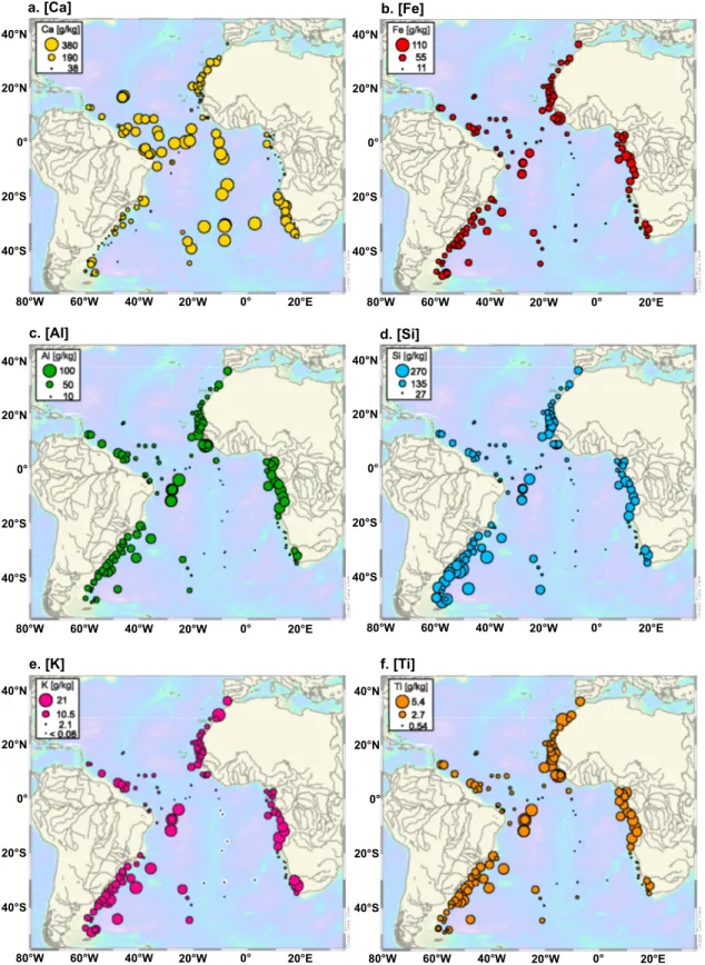
[18] Figure 3 shows the distribution of major
ele-ment concentrations in Atlantic surface sedi-ments. We observe (1) very similar distributions of the terrigenous elements Al, Si, Fe, K, and Ti (Figures 3b–3f), and (2) a clearly opposite distri-bution of Ca (Figure 3a). Ca exhibits the highest concentrations on the mid-Atlantic ridge and the lowest concentrations along the African and South American margins (Figure 3a), in particular in areas close to the mouth of the Senegal, Gambia, Sanaga, Congo and Plata Rivers (see Figure 1b for the location of the rivers). The Ca distribution in the Atlantic surface sediments follows the modern distribution of Atlantic carbonate content [Biscaye et al., 1976; Balsam and McCoy, 1987; Archer, 1996]. Most of the Ca contained in the Atlantic surface sediments can therefore be assigned to car-bonates, most likely of marine origin, as shown by earlier studies [e.g., Jansen et al., 1998; Arz et al.,
Figure 3. Spatial distribution of major element concentration (in g/kg) in Atlantic surface sediments (Table S1). Distribution of (a) Ca, (b) Fe, (c) Al, (d) Si, (e) K and (f) Ti. Black diamonds in (e) indicate samples for which the K concentration was below the detection limit (0.08 g/kg).
Geochemistry Geophysics
1999; Richter et al., 2006; Jullien et al., 2007; Itambi et al., 2010]. In contrast, the concentra-tions of the five terrigenous elements are higher on the African and South American margins com-pared to the mid-Atlantic ridge (Figures 3b–3f ). This pattern indicates a clear imprint of terrige-nous input on the elemental composition of modern Atlantic surface sediments located on continental margins.
[19] The elemental distributions do not follow
the above pattern in three distinct regions. We observe relatively high Ca concentrations and low concentrations of terrigenous elements (1) in African samples located between 19°S and 29°S off Namibia and (2) in samples off Northwest Africa between 18°N and 29°N (Figure 3). (3) We record extremely low Ca concentrations and high concentrations of terrigenous elements in eight samples (water-depth ranging from 4100 to 5600 m) distributed in the abyssal western Atlantic basin between 44°S and 4°S, parallel to the South American continent (Figure 3). Samples from these three particular regions indicate that factor other than the input of terrigenous material influ-ence the geochemical composition of surface sedi-ments on a regional scale (see section 4.1).
3.2. Distribution of Elemental Ratios
[20] Figure 4 shows the spatial distribution of the
most commonly used elemental ratios Fe/Ca, Ti/Ca, Ti/Al, Fe/K and Al/Si. To account for the lack of symmetry exhibited by ratios, we present the logarithms of elemental ratios (see Aitchison and Egozcue [2005] for a review of the treatment of compositional data).
3.2.1. Distribution of Fe/Ca and Ti/Ca
[21] In Figures 4a–4b we show the Fe/Ca and Ti/Ca
ratios of samples located above the lysocline (see section 4.1). As expected from the distributions of single elements (Figure 3), the Fe/Ca and Ti/Ca ratios present similar distributions (Figures 4a and 4b). Fe/Ca and Ti/Ca values are very low on the mid-Atlantic ridge and high along the conti-nental margins, in particular in regions of high fluvial input from the Gambia, Sanaga, Congo, and Orange Rivers along Africa, and from the Orinoco, Amazon and Plata Rivers along South America (Figures 4a and 4b). We observe intermediate values on the mid-Atlantic ridge north of the equator (Figures 4a and 4b), i.e., in regions of high dust deposition [e.g., Mahowald et al., 2005; Chavagnac et al., 2008] (Figure 1a).
3.2.2. Distribution of Ti/Al
[22] Four sites located close to volcanic islands
show high values Ti/Al compared to the main dis-tribution (Figure 4c): (1) site GeoB5556–3 (29.3°N, 14.1°W) located to the north of the Canary Islands (ln(Ti/Al) = "1.55), (2) site GeoB2019–2 (36.1°S, 8.8°W) from the eastern flank of the mid-Atlantic ridge to the east of the Tristan da Cunha island (ln(Ti/Al) = "1.69), (3) site GeoB1412–2 (15.7°S, 7.8°W) located to the west of the Santa Helena island (ln(Ti/Al) = "2.50), and (4) site GeoB4908–3 (0.7°S, 6.8°E) off Cameroon to the south of the São Tomé island (ln(Ti/Al) = "2.32).
[23] Additionally, intermediate Ti/Al values (on
average ln(Ti/Al) of "2.73 # 0.09, 1s standard deviation) are observed in (1) samples located off southern Brazil and Uruguay between 24°S and 38°S, (2) sites GeoB3936–2 and GeoB3939–1 off Barbados (ca. 12.5°N, 58.5°W) (see Figure 2 for the location of specific regions), (3) sites on the mid-Atlantic ridge to the north of 5°N, (4) site GeoB2910–2 (4.9°N, 21.1°W) on Sierra Leone Rise, (5) samples located off Northwestern Africa between 10°N and 25°N, and (6) sites located off Namibia at 18°S and 24°S (Figure 4c). With the exception of samples located along Southern Brazil and Uruguay, these sites are located in regions where the deposition of African eolian material dominates the terrigenous fraction [e.g., Mahowald et al., 2005] (Figure 1a).
[24] Finally, the Ti/Al ratio exhibits low values
(ln(Ti/Al) = "2.97 # 0.06) at sites (1) located along the African margin between 9°N and 15°S (with the exception of site GeoB4908–3 next to the São Tomé island), and (2) along the South Amer-ican margin of Northeastern Brazil and Guyana between 1°S and 10°N (Figure 4c). Both regions mainly receive terrigenous input of fluvial origin, from the Senegal [Gac and Kane, 1986], Niger [Zabel et al., 2001] and Congo [Eisma and van Bennekom, 1978] Rivers on the one hand, and from the Amazon River [Muller-Karger et al., 1988; Zabel et al., 1999] on the other hand.
3.2.3. Distribution of Fe/K
[25] Figure 4d shows the distribution of the Fe/K
ratio in Atlantic surface sediments. K concentrations below the detection limit in eight samples from the mid-Atlantic ridge (Figure 3e) explain the corre-sponding gap in the Fe/K distribution (Figure 4d). Similarly, very high Fe/K values (ln(Fe/K) > 2.00) recorded in sites at 36°S and around the equator on
Figure 4. Spatial distribution of the ln-ratios of (a) Fe/Ca, (b) Ti/Ca, (c) Ti/Al, (d) Fe/K, and (e) Al/Si. The Fe/Ca and Ti/Ca ratios in panels (a) and (b) are shown for the samples located above the lysocline only. In panels (c), (d) and (e) are indicated the Ti/Al, Fe/K and Al/Si ratios of available sources: dust samples (stars) from North Africa [Wilke et al., 1984; Orange and Gac, 1990; Orange et al., 1993; Stuut et al., 2005; Moreno et al., 2006], Namibia [Annegarn et al., 1983] and Patagonia [Gaiero et al., 2007], as well as river suspended sediment (diamonds) from the Senegal [Gac and Kane, 1986], Niger [Martin and Meybeck, 1979; Gaillardet et al., 1999], Congo [Sholkovitz et al., 1978; Martin and Meybeck, 1979], Orinoco [Hirst, 1962; Eisma et al., 1978; Martin and Meybeck, 1979], Amazon [Sholkovitz et al., 1978; Martin and Meybeck, 1979], Plata [Martin and Meybeck, 1979; Depetris et al., 2003] and Patagonian rivers [Gaiero et al., 2007] (see Table S3 for details). The main South American and African rivers are shown in each panel. The maps were generated with the Ocean Data View software [Schlitzer, 2010].
Geochemistry Geophysics
the mid-Atlantic ridge (Figure 4d) result from very low K concentrations in these samples (Figure 3e). Additionally, we record a high Fe/K ratio (ln(Fe/K) = 1.56) in site GeoB5556–3 (29.3°N, 14.1°W) located to north of the Canary Islands (Figure 4d), similar to the Ti/Al ratio at this site.
[26] Relatively high Fe/K values (ln(Fe/K) = 1.34 #
0.32) are observed in continental margin samples from three tropical areas (Figure 4d): (1) in sites located along the African margin between 17°N and 8°S, i.e., in areas receiving strong fluvial input from the Senegal, Niger and Congo Rivers; (2) in sites located off Namibia between 23°S and 29°S, which receive terrigenous input from the Orange river; and (3) in samples located along the South American margin between 24°S and 12°N, with the exception of the samples in the vicinity of the Amazon River mouth. Conversely, the Fe/K dis-tribution exhibits lower values (ln(Fe/K) = 0.83 # 0.24) in drier regions (Figure 4d): (1) in samples located along the South American margin south of 24°S, and (2) in sites along the African mar-gin north of 17°N and between 10°S and 22°S. Interestingly, we also record low Fe/K values in
sites located closest to the Amazon mouth between 3°N and 10°N (ln(Fe/K) = 0.81 # 0.05) (Figure 4d). 3.2.4. Distribution of Al/Si
[27] We observe high Al/Si values (ln(Al/Si) =
"0.76 # 0.11) in Atlantic surface sediments from tropical regions (Figure 4e): (1) along the African margin between 10°N and 15°S, and (2) along the South American margin between 12°N and 24°S. In contrast, intermediate Al/Si values (ln(Al/Si) = "1.16 # 0.18) are found in drier regions: (1) along the African margin between 29°N and 10°N, (2) along the African margin between 15°S and 35°S, and (3) along the South American mar-gin between 24°S and 35°S (Figure 4e). Finally, the Al/Si distribution exhibits low Al/Si values (ln(Al/Si) = "1.63 # 0.30) in two distinct regions: (1) along the South American margin between 37°S and 49°S, and (2) in sites GeoB1612–9 (4.3°S, 10.3°W) and GeoB1808–7 (5.8°S, 9.4°W) from the mid-Atlantic ridge (Figure 4e).
3.3. Fuzzy c-means Cluster Analysis
[28] We present in Figure 5 the results of the fuzzy
c-means cluster analysis performed on continental Figure 5. Results of the fuzzy c-means analysis, performed on the 96 samples located on the continental margins (see Table S2 for details). (a) Elemental composition (Si, Al, Fe, K, Ti) of cluster center 1 (CC1), cluster center 2 (CC2) and cluster center 3 (CC3). (b) Logarithm of elemental ratios (Fe/K, Al/Si and Ti/Al) of the three cluster centers. Spatial distribution of the membership values of samples to (c) CC1, (d) CC2, and (e) CC3. We only show the highest membership value of each sample to the cluster centers (see Table S2 for all values).
margin samples (Table S2). We selected a solution with three cluster centers that highlight three groups with coherent geochemical compositions (Figure 5a). Samples located closest to Cape Blanc off Mauritania (19–22°N), along the Namibian and South African margins (17–35°S), at the mouth of the Plata River and further south along the Argentinean margin (35–49°S) demonstrate the highest membership to the first cluster center (CC1) (Figure 5c and Table S2). Across the suite of elements included in the cluster analysis, these samples contain low proportions of Al (16%), Fe (9%), K (4%) and Ti (1%) and a particularly high proportion of Si (70%) (Figure 5a).
[29] A lower proportion of Si (60%) and higher
proportions of K (5%), Fe (12%) and Al (22%) characterize the second cluster center (CC2) (Figure 5a). Samples from Northwest Africa to the north of 17°N, off Angola (10°S-14°S), off Namibia and South Africa (23°S-32°S), close to the Amazon River mouth (3°N-9°N) and north of the Plata River mouth (24°S-35°S) show the highest membership to CC2 (Figure 5d and Table S2). These samples present coherent geochemical com-positions characterized by intermediate Al/Si and low Fe/K values (Figure 5b). Located at subtropical latitudes, they mainly receive terrigenous input of fluvial origin for the South American margin and of eolian origin for the African margin (Figure 1). This cluster center indicates that similar geochem-ical compositions of sediment samples can reflect different environmental settings.
[30] The lowest proportions of Si (57%) and
K (3%) and highest proportions of Al (25%) and Fe (13%) characterize the third cluster center (CC3) (Figure 5a). Samples located off the Canary Islands (ca. 29°N), off Africa between 17°N and 8°S, off Brazil between 3°S and 24°S and off Barbados islands (ca. 13°N) demonstrate the highest member-ship to CC3 (Figure 5e and Table S2). The highest Al/Si and Fe/K values characterize their elemental composition (Figure 5b). With the exception of site GeoB5556–3 near the Canary Islands, the samples with a highest membership to CC3 are located in Atlantic tropical regions, where the deposition of fluvial material dominates the sedimentation. Interestingly, samples located close to the Amazon River mouth do not exhibit the highest member-ship value to CC3 (Figure 5e). This cluster analysis nevertheless shows that tropical Atlantic surface sediments on the one hand, and subtropical surface sediments on the other hand, display distinct
terrigenous compositions reflecting characteristic climatic regimes and soil types.
4. Discussion
4.1. Dilution Effects
[31] Elemental concentrations convey relative
infor-mation on the geochemical composition of the sedi-ment. Any variation in the concentration of one element will directly affect the concentration of other elements measured in the sediment. In our study we identify three processes that regionally induce such dilution effects: variations in the logical productivity of (1) carbonates, and of (2) bio-genic opal, and (3) changes in carbonate dissolution. The potential dilution effect of (4) high organic carbon contents in Atlantic surface sediments is also discussed.
[32] 1. Sites from Northwest Africa and off Namibia
display relatively high Ca concentrations and low concentrations of terrigenous elements for continen-tal margin samples (Figure 3). They belong to the Mauritanian upwelling system [e.g., Mittelstaedt, 1983, 1991] and Benguela upwelling system [e.g., Andrews and Hutchings, 1980; Nelson and Hutchings, 1983]. In these regions, enhanced sur-face water biological productivity [e.g., Bailey and Chapman, 1991; Van Camp et al., 1991] increases the deposition of carbonates on the seafloor [e.g., Jahnke and Shimmield, 1995] and the relative con-tent of Ca in the sediment (Figure 3a).
[33] 2. The cluster analysis highlights the high
proportion of Si (Figure 5a) at sites located along the Argentinean margin south of the Plata River mouth, off Cape Blanc, and along the Namibian and South African margin (Figure 5c). The African samples belong to the Benguela and Mauritanian upwelling systems [e.g., Mittelstaedt, 1983; Nelson and Hutchings, 1983]. These areas are character-ized by a high biogenic opal production [e.g., Bailey and Chapman, 1991; Romero et al., 2002], which explains the high Si concentrations and low Al/Si ratios of surface sediments. Moreover, the Al/Si ratio of sediments located along the Argentinean margin remains lower than that of any atmospheric dust and river suspended samples collected in Patagonia (Figure 4c and Table S3). This feature indicates the influence of external processes on the geochemical composition of Argen-tinean margin samples. These samples are located along the path of the Malvinas Current up to the Brazil-Malvinas Confluence, where the upper water
Geochemistry Geophysics
column is bathed by subantarctic water masses [e.g., Gordon, 1989; Peterson and Stramma, 1991]. They are hence located in a region of high siliceous pro-ductivity and receive strong input of biogenic opal [e.g., Romero and Hensen, 2002], explaining the very low Al/Si values. Similarly, the two samples from the mid-Atlantic ridge at !5°S present high Si concentrations indicated by low Al/Si values (Figure 4e). Located in the equatorial Atlantic upwelling system, they also contain high propor-tions of biogenic opal [Soldatov and Murdmaa, 1970].
[34] 3. Samples from the abyssal southwestern
Atlantic exhibit particularly low Ca concentrations and high concentrations of terrigenous elements for open ocean sites (Figure 3). With a water-depth ranging from 4100 to 5600 m, these sites are located below the modern lysocline [Volbers and Henrich, 2004] (Figure 1). Corrosive Antarctic Bottom Waters intensively dissolve carbonates deposited on the seafloor [Volbers and Henrich, 2004], leaving behind the terrigenous material and biogenic opal fractions.
[35] 4. Mollenhauer et al. [2004] document total
organic carbon contents lower than 1% in most of South Atlantic surface sediments, with higher values up to 3% near the Plata and Congo River mouths and 10% in the Benguela upwelling system. High organic carbon contents have no influence on the elemental ratios considered in this study and could decrease the relative concentrations of measured single elements. We however do not observe any clear decrease in the single element concentrations in the Benguela upwelling region where the organic carbon content is the highest [Mollenhauer et al., 2004]. This result suggests a negligible effect of organic carbon content on ele-mental distributions in the South Atlantic.
[36] Altogether, the potential influence of dilution
and dissolution effects on the geochemical compo-sition of the sediment prompt us to be cautious with the interpretation of elemental compositions used for paleoclimate reconstructions. First, the con-centrations of single elements are interdependent and directly influenced by dilution effects. There-fore we do not recommend using the concentrations of single elements to reconstruct terrestrial paleo-climate. Less sensitive to dilution effects, elemental ratios are more useful [e.g., Weltje and Tjallingii, 2008]. Nevertheless, we note that elemental ratios including Ca (e.g., Fe/Ca, Ti/Ca) do not simply reflect the amount of terrigenous material deposited onto the seafloor. They rather reflect the amount of
terrigenous input relative to the marine content. Because the concentration of Ca in the sediment depends on changes in marine carbonate produc-tivity and dissolution, the application of these ratios to paleoclimate reconstructions requires a detailed understanding of the modern environmental setting and of its evolution during past climate changes.
4.2. Elemental Ratios as Proxies for Terrestrial Climate
4.2.1. Ti/Al, a Proxy for Eolian Versus Fluvial Input
[37] The distribution of Ti/Al in Atlantic surface
sediments mainly shows intermediate Ti/Al values in areas of high dust deposition and low Ti/Al values in regions dominated by the input of sus-pended material from the Senegal, Niger, Congo and Amazon Rivers (Figure 4c and section 3.2.2). These results support the use of the Ti/Al ratio as a proxy for eolian versus fluvial terrigenous input [Lourens et al., 2001; Itambi et al., 2009]. High Ti/Al values indicate an increased contribution of dust input relative to the supply of river suspension matter.
[38] Available information on the geochemical
composition of atmospheric dust and river sus-pended samples (Table S3) supports our interpre-tation of the Ti/Al ratio. Atmospheric dust samples collected along the West African coast between 25°N and 10°N [Stuut et al., 2005], as well as dust samples from different North African regions [Wilke et al., 1984; Orange and Gac, 1990; Orange et al., 1993; Moreno et al., 2006], exhibit intermediate Ti/Al values (Table 3 and Figure 4c). These values are similar to those measured in sur-face sediments from Northwestern Africa (10°N– 25°N) and the tropical North Atlantic (Table 3 and Figure 4c), i.e., located below the dust plume [e.g., Mahowald et al., 2005; Chavagnac et al., 2008] (Figure 1a). In addition, suspended sediment from the Senegal [Gac and Kane, 1986], Niger [Martin and Meybeck, 1979; Gaillardet et al., 1999] and Congo Rivers [Sholkovitz et al., 1978; Martin and Meybeck, 1979] show low Ti/Al values (Table 3 and Figure 4c). These values are similar to those recorded in surface sediments from the tropical African margin (10°N–15°S) where fluvial input dominates (Table 3 and Figure 4c). Low Ti/Al values measured in Amazon River suspended material [Sholkovitz et al., 1978; Martin and Meybeck, 1979] (Table 3 and Figure 4c) also agree with the Ti/Al values recorded along the North Brazilian and
Table 3. Summary of Elemental Ratio Values From (Left-Hand Side) Atlantic Surface Sediments Averaged for Specific Regions and (Right-Hand Side) Fluvial and Eolian Material of Relevant Sources a Atlantic Surface Sediments Available Sources Region Mean # 1SD Region Mean # 1SD Reference b ln (Ti/Al ) North Africa (25°N –10°N), Sierra Leone, Barbados, mid-Atlantic ridge (>5°N) " 2.75 # 0.07 North African dust (>6°N) " 2.60 # 0.37 1 African tropical margin (10°N –15°S) " 2.96 # 0.07 Senegal, Niger, Congo suspended matter " 3.03 # 0.14 2 North Brazilian margin (10°N –5°S) " 2.98 # 0.05 Amazon suspended matter " 3.03 # 0.33 3 South Brazilian and Uruguayan margin (24°S –38°S) " 2.74 # 0.07 Plata suspended matter " 2.56 # 0.19 4 ln (Fe/K ) African margin: north of 17°N and south of 10°S 0.85 # 0.25 North African (>10°N) and Namibian dust 0.77 # 0.28 5 African tropical margin (17°N –10°S) 1.37 # 0.33 Senegal, Niger, Congo suspended matter Atmospheric dust along Africa (10°N –7°S) 1.79 # 0.25 1.30 # 0.10 2 6 North Brazilian margin (10°N –3°N) 0.81 # 0.05 Amazon suspended matter 1.09 # 0.04 3 South Brazilian and Uruguayan margin (24°S –36°S) 0.79 # 0.08 Plata suspended matter 0.85 # 0.19 4 ln (Al/Si ) North African margin (>10°N) " 1.10 # 0.15 North African dust " 1.63 # 0.20 7 African tropical margin (10°N –15°S) " 0.75 # 0.13 Senegal, Niger, Congo suspended matter " 0.57 # 0.03 2 South American margin (12°N –24°S) " 0.77 # 0.09 Amazon suspended matter " 0.81 # 0.04 3 South Brazilian and Uruguayan margin (24°S –36°S) " 1.10 # 0.11 Plata suspended matter " 1.07 # 0.10 4 aSee Table S3 details. We indicate the averaged ratio values # 1 standard deviation (SD) in log-space. b References: 1 [Wilke et al. ,1984; Orange and Gac ,1990; Orange et al. ,1993; Stuut et al. ,2005; Moreno et al. ,2006]; 2 [Sholkovitz et al. ,1978; Martin and Meybeck ,1979; Gac and Kane ,1986; Gaillardet et al. ,1999]; 3 [Sholkovitz et al. ,1978; Martin and Meybeck ,1979]; 4 [Martin and Meybeck ,1979; Depetris et al. ,2003]; 5 [Annegarn et al. ,1983; Wilke et al. ,1984; Orange and Gac ,1990; Orange et al. , 1993; Stuut et al. , 2005; Moreno et al. , 2006]; 6 [Stuut et al. , 2005]; 7 [Wilke et al. , 1984; Orange and Gac , 1990; Orange et al. , 1993; Moreno et al. , 2006]. Geochemistry Geophysics
Guyanan margins between 10°N and 1°S (Table 3 and Figure 4c). This result supports the sugges-tion that Amazon suspended material constitutes the dominant source of terrigenous sediments in the western equatorial Atlantic, whereas North African dust deposition dominates on the eastern side of the mid-Atlantic ridge [Zabel et al., 1999; Abouchami and Zabel, 2003].
[39] Suspended sediments from the Plata River
exhibit intermediate Ti/Al values [Martin and Meybeck, 1979; Depetris et al., 2003] (Table 3 and Figure 4c). These values are similar to the Ti/Al values recorded in surface sediments off south Brazil and Uruguay between 24°S and 38°S (Table 3 and Figure 4c). First, the extension of the Patagonian dust plume is limited to southernmost latitudes (Figure 1a). Second, most of the precipi-tation that falls over southern Brazil and Uruguay within the drainage basin of the Plata River is directed to the Plata River mouth, together with the relatively high load of suspended sediments (ca. 36°S) [e.g., Depetris et al., 2003]. Fluvial material, which is transported northward from the Plata River mouth by a shelf coastal current [e.g., Piola et al., 2005], therefore dominates the sedimentation along Uruguay and southern Brazil [e.g., Frenz et al., 2004; Mahiques et al., 2008]. The Ti/Al ratio of Plata River sediments however remains higher than that of the Senegal, Niger, Congo and Amazon Rivers (Table 3 and Figure 4c). Suspended sediments from the Plata River mostly derive from the mountainous drain-age basin of the Bermejo River and other Andean tributaries. They carry the signature of young Andean volcanic rocks rich in Ti oxides, with some influence of the lowland Jurassic-Cretaceous tholeiithic basalts [Depetris et al., 2003]. This feature explains why Ti/Al values in surface sedi-ments off South Brazil and Uruguay are relatively high compared to those of other major rivers (Table 3 and Figure 4c). Moreover, it highlights the influence of terrigenous input with a mafic rock origin on the Ti/Al ratio of surface sedi-ments. The high Ti/Al values measured in surface sediment samples located close to volcanic islands (Figure 4c and section 3.2.2) support this inter-pretation. Basaltic lava from the Canary [Hoernle and Schmincke, 1993; Kuss and Kremling, 1999], Tristan da Cunha [Weaver et al., 1987], Santa Helena [Weaver et al., 1987] and São Tomé [Fitton and Dunlop, 1985] islands are also enriched in Ti oxides.
[40] In summary, the Ti/Al ratio from Atlantic
sur-face sediments records variations in the relative
input of eolian (high Ti/Al) versus fluvial (low Ti/Al) terrigenous material, in areas of dust depo-sition and not affected by the input of mafic material. This corroborates the interpretation that increased Ti/Al values downcore in marine sedi-ment cores represent an enhanced proportion of dust particles (versus reduced river suspended material) in regions of dust deposition. Past Ti/Al variations may also reflect changes in the provenance of terrig-enous material (i.e., dominant watershed area) in a purely fluvial system [Montero-Serrano et al., 2009, 2011].
4.2.2. Fe/K, a Tracer for Terrestrial Climatic Zones
[41] The Fe/K distribution along the Atlantic
con-tinental margins globally shows high values in African and Brazilian surface sediments from tropical areas and low Fe/K values in drier regions (Figures 4d and 5e and section 3.2.3). The geo-chemical composition of dust and river suspension samples from Africa supports this global pattern (Table 3, Figure 4d, and Table S3). A low Fe/K ratio characterizes dust particles collected at dif-ferent places in North Africa [Wilke et al., 1984; Orange and Gac, 1990; Orange et al., 1993; Moreno et al., 2006], off Northwestern Africa [Stuut et al., 2005], off Angola [Stuut et al., 2005], and in Namibia [Annegarn et al., 1983] (Table 3 and Figure 4d). Their Fe/K values agree with those recorded in African margin surface sediments located north of 17°N and south of 10°S (Table 3 and Figure 4d), i.e., from relatively dry regions. In addi-tion, low Fe/K values observed at subtropical lati-tudes in both dust particles and African surface sediments reflect the presence over Africa of slightly weathered soils relatively enriched in K [Moore and Dennen, 1970; Middelburg et al., 1988; Driessen et al., 2001] (Figure 2). These low Fe/K values indicate the dominant deposition of only slightly weathered particles originating from rela-tively dry areas on the subtropical African margin. Conversely, suspended material from the Senegal [Gac and Kane, 1986], Niger [Martin and Meybeck, 1979; Gaillardet et al., 1999], and Congo River [Sholkovitz et al., 1978; Martin and Meybeck, 1979] exhibits high Fe/K ratios (Table 3 and Figure 4d). These values are similar to those measured in trop-ical African sediments between 17°N and 10°S (Table 3 and Figure 4d), i.e., in regions of high fluvial sediment discharge (Table 1). In addition, the spatial Fe/K distribution observed along the African continental margin and in African dust and river suspended samples (Figure 4d) reflects the
spatial distribution of African soil types (Figure 2). High Fe/K values recorded in the tropics agree with the presence of intensively weathered soils (Ferralsols, Plinthosols, Acrisols) enriched in Fe over the adjacent continent [Moore and Dennen, 1970; Middelburg et al., 1988; Driessen et al., 2001] (Figure 2 and Table 2). Finally, atmo-spheric dust samples collected along the West African coast between 10°N and 7°S show higher Fe/K values than further north [Stuut et al., 2005; Mulitza et al., 2008] (Table 3 and Figure 4d). Increased Fe/K values of dust particles in the tro-pics reflect dust originating from highly weathered soils [Chiapello et al., 1997; Caquineau et al., 2002; Moreno et al., 2006]. The deposition of such dust particles is likely to contribute to the high Fe/K values recorded in surface sediments from the tropical African margin. These high sed-imentary Fe/K values reflect the fluvial or eolian input of intensively weathered material derived from tropical African regions. Altogether, the high similarity between the spatial distribution of Fe/K in African margin sediments and the distribution of African soil types indicates that terrigenous mate-rial deposited on continental margins is transported from the adjacent continent. In addition, the pre-ceding comparison of Fe/K values recorded in African surface sediments and African terrigenous sources with the distribution of African soil types indicates that the Fe/K ratio in African margin sediments reflects the relative terrigenous input of highly weathered (mainly fluvial) material origi-nating from tropical latitudes versus slightly weath-ered (eolian) material from subtropical latitudes. [42] Surface sediments of two African arid regions
reveal relatively high Fe/K values. First, north of the Canary Islands (GeoB5556–3, 29.3°N, 14.1°W), the high Fe/K value reflects the Fe-enriched sig-nature of mafic rocks [Hoernle and Schmincke, 1993], in a manner similar to that described for the Ti/Al ratio (see section 4.2.1). This example highlights the sensitivity of the Fe/K ratio to ter-rigenous input of mafic material. Second, samples located along the Namibian and South African margin (between 23°S and 33°S) exhibit high Fe/K values for a dry region. These values reflect the input of Orange River suspended material and/or of dust particles that originate from inland dunes of the Namibian desert. Rich in iron, these dunes possess a distinctive reddish-brown color [Scholz, 1972; Bremner and Willis, 1993].
[43] High Fe/K values observed in South
Ameri-can continental margin samples from tropical areas (Figure 4d) reflect the presence of highly
weathered soils in the tropical sector of South America (Figure 2), where annual rainfall is gen-erally high (Figure 1b). The low Fe/K values determined between ca. 24°S and the mouth of the Plata River agree with low Fe/K values character-istic of suspended material from the Plata River [Martin and Meybeck, 1979; Depetris et al., 2003] (Table 3 and Figure 4d), corroborating the suggested northward transport of the Plata River sedimentary plume [e.g., Frenz et al., 2004; Mahiques et al., 2008]. We cannot rule out the influence of mafic material (in a similar manner to the Ti/Al ratio) on the geochemical signature of Plata River sus-pended material. The input of mafic material would result in high Fe/K values, as is observed next to the Canary islands (Figure 4d). The low Fe/K values characterizing Plata River sediments more likely reflect the presence of illite-rich material derived from the mountainous drainage basin of the Bermejo River and other Andean tributaries, which drain moderately weathered soils [Depetris and Griffin, 1968; Bertolino and Depetris, 1992; Depetris et al., 2003]. These results support the use of the Fe/K ratio to reconstruct South American climatic zones characterized by different degrees of chemical weathering.
[44] We observed particularly low Fe/K values in
surface sediments affected by Amazon River input between 3°N and 10°N [e.g., Zabel et al., 1999; Abouchami and Zabel, 2003] for a region of high sediment discharge (Figures 4d, 5d, and 5e). Low Fe/K values also characterize the suspension mate-rial from the Amazon River [Sholkovitz et al., 1978; Martin and Meybeck, 1979], if compared to the Senegal [Gac and Kane, 1986], Niger [Martin and Meybeck, 1979; Gaillardet et al., 1999] and Congo River [Sholkovitz et al., 1978; Martin and Meybeck, 1979] sediments (Table 3 and Figure 4d). This fea-ture of the Amazon River is surprising in the sense that intensively weathered soils (Ferralsols, Acri-sols, Table 2) cover most of the lowland Amazon basin [FAO et al., 2009] (Figure 2), which con-stitutes 88% of the entire drainage basin [Guyot et al., 2007]. These low Fe/K values nevertheless agree with a high proportion of K related to a high illite content (30%) for tropical areas, recorded in nearby Atlantic surface sediments [Biscaye, 1965; Petschick et al., 1996] and in suspended material from the Amazon River [Guyot et al., 2007]. Due to the very strong rate of physical erosion in the Andes, the clay mineral composition of Andean rivers dominates that of Amazon suspended sedi-ments, while the imprint of lowland rivers remains small [Guyot et al., 2007]. Therefore, low Fe/K
Geochemistry Geophysics
values recorded in surface sediments between the Amazon River mouth and Guyana confirm the dominant Andean origin of Amazon suspended material on the one hand, and the dominant sedi-mentation of fluvial material in the western basin of the equatorial North Atlantic on the other hand. These values also indicate the influence of the topography of drainage basins on the geochemical composition of suspended material of large South American Rivers [Milliman and Syvitski, 1992]. This feature suggests the potential of the Fe/K ratio to reconstruct changes in the relative contribution of mountainous versus lowland sediment loads in Amazon suspended matter that deposits in the Atlantic.
[45] In summary, the Fe/K in surface sediments is
suitable to reconstruct African and South American climatic zones, in areas not affected by the input of mafic material. The application of our results to paleoclimate reconstructions suggests that Fe/K values increasing downcore in marine sediments indicate the presence of more humid climatic con-ditions within the catchment area [Mulitza et al., 2008]. Diagenetic Fe remobilization can however occur during redox processes in the sediment [e.g., Middelburg et al., 1988; Zwolsman and van Eck, 1999] and bias paleoclimate reconstructions.
4.2.3. Al/Si, Another Tracer for Terrestrial Climatic Zones
[46] The Atlantic Al/Si distribution exhibits high
values in continental margin samples from tropical areas and lower values in drier regions (Figures 4e, 5d, and 5e). The high Al/Si values form a tropical belt related to high kaolinite contents (>40%) in Atlantic surface sediments [Biscaye, 1965; Petschick et al., 1996]. These values agree with the very high Al/Si values measured in suspended sediments from the Senegal [Gac and Kane, 1986], Niger [Martin and Meybeck, 1979; Gaillardet et al., 1999] and Congo Rivers [Sholkovitz et al., 1978; Martin and Meybeck, 1979] (Table 3 and Figure 4e), which drain highly weathered soils enriched in kaolinite (high Al content) [Driessen et al., 2001; FAO et al., 2009] (Figure 2). The distribution of Al/Si in tropi-cal Atlantic sediments (Figure 4e) also shows high similarities to the African and South American dis-tribution of intensively weathered soils (Figure 2). This result confirms the deposition on Atlantic con-tinental margins of terrigenous material originating from the adjacent continent.
[47] Amazon suspended sediments [Martin and
Meybeck, 1979; Sholkovitz and Price, 1980]
exhibit lower Al/Si values than the tropical African rivers (Table 3 and Figure 4e). This feature high-lights the influence of slightly chemically weath-ered material from Andean tributaries on Amazon clay mineral assemblages [Guyot et al., 2007]. However, high Al/Si values observed along the South American margin north of 24°S (Figure 4e) reflect the high proportion of kaolinite in marine sediments adjacent to small tropical South Ameri-can rivers [Biscaye, 1965]. Because of a reduced variety of pedogenic conditions in their drainage basins, small South American Rivers deliver sedi-ments enriched in kaolinite compared to large riv-ers [Biscaye, 1965]. High Al/Si values in Atlantic surface sediments hence reflect the (fluvial) input of highly weathered material from tropical humid regions.
[48] Decreased Al/Si values measured in sediment
samples from the south Brazilian and Uruguayan margins (24°S–36°S) agree with the elemental composition of the Plata River suspended matter [Martin and Meybeck, 1979; Depetris et al., 2003] (Table 3 and Figure 4e). These Al/Si values trace the fluvial supply of less-weathered terrigenous material from the Plata River drainage basin with a strong contribution of the Bermejo River and other Andean tributaries [Depetris and Griffin, 1968; Bertolino and Depetris, 1992]. Finally, the rela-tively low Al/Si values recorded off Northwest Africa (north of 10°N) agree with the geochemical composition of North African dust particles [Wilke et al., 1984; Orange and Gac, 1990; Orange et al., 1993; Moreno et al., 2006] (Table 3 and Figure 4e). These values reflect the eolian input of slightly weathered material from (semi-) arid regions. [49] Therefore, in a manner similar to the Fe/K
ratio, the Al/Si ratio measured in Atlantic surface sediments reflects the relative input of highly weath-ered material derived from tropical humid regions versus slightly weathered particles from drier areas. The ratio is thus suitable for reconstructing African and South American climatic zones characterized by different degrees of continental weathering. For paleoclimate reconstructions, Al/Si values increas-ing downcore in marine sediment cores will indi-cate wetter climatic conditions in the catchment area. In parallel, changes in the Al/Si ratio are linked to variations in the grain size of terrigenous material, with increasing Al/Si values being related to an increased amount of fluvial fine-grained material off Senegal [Mulitza et al., 2008]. Recent data from the Amazon tributaries also indicate a clear inverse relationship between the Al/Si ratio and the grain size of suspended material [Bouchez
et al., 2011]. The Al/Si ratio is however not suit-able for terrestrial reconstructions in environments subject to high biogenic opal productivity (see section 4.1).
5. Conclusions
[50] In this study, we mapped for the first time
the concentrations of major elements (Ca, Fe, Al, Si, K, Ti) in surface sediments from the tropical and subtropical Atlantic (36°N–49°S). Our data set shows high concentrations of terrigenous elements and low concentrations of Ca along the African and South American margins, and the opposite situation on the mid-Atlantic ridge. This feature reflects the imprint of terrigenous input along the African and South American margins. However, factors other than the input of terrigenous material regionally influence the geochemical composition of Atlantic surface sediments. From the Atlantic distribution of single elements and the cluster analysis, we identify here (1) the dilution of terrigenous ele-ments by carbonates and biogenic opal in regions of enhanced biological productivity and (2) the dis-solution of carbonates at greater water-depths. Single element concentrations are sensitive to these effects. Similarly, elemental ratios including Ca (e.g., Fe/Ca and Ti/Ca) reflect the amount of ter-rigenous input relative to the marine content, which is affected by dilution and dissolution effects. They hence do not allow reliable reconstructions of terrestrial climate conditions, in particular for past climate changes. Insensitive to dilution effects, ele-mental ratios including terrigenous elements are more appropriate [e.g., Weltje and Tjallingii, 2008]. They reflect the relative variation of two terrigenous elements that can be associated with contrasting situations (e.g., dry versus humid conditions, phys-ical versus chemphys-ical weathering).
[51] The cluster analysis shows that coherent
terrig-enous compositions characterize the sediments from tropical Atlantic regions on the one hand, and sub-tropical regions on the other hand, reflecting differ-ent climatic regimes and source soils. We compared the elemental composition of Atlantic surface sedi-ments with that of relevant fluvial and eolian mate-rial. The geochemical composition of terrigenous material deposited in the ocean determines the ele-mental ratios (e.g., Ti/Al, Fe/K, Al/Si) of surface sediments. The composition of terrigenous material depends on its source (i.e., rock types, soil types and their degree of chemical weathering) and ultimately reflects the climate conditions within the catchment
areas. The Atlantic distribution of the Ti/Al ratio supports its use as a proxy for eolian versus fluvial input of terrigenous material. However, our results highlight the sensitivity of Ti/Al to the input of mafic material. The distributions of the Fe/K and Al/Si ratios in Atlantic surface sediments are highly similar to those of major soil types in Africa and South America. This result indicates the deposition on Atlantic continental margins of terrigenous material originating from the adjacent continent. In addition, the Fe/K and Al/Si ratios of Atlantic sediments reflect the relative input of terrigenous material from climatic zones characterized by dif-ferent degrees of chemical continental weathering. High values indicate the dominant input of highly weathered material derived from tropical humid regions, while low Fe/K and Al/Si values reflect the input of only slightly chemically weathered material formed under drier conditions. Therefore both ratios are suitable to reconstruct African and South American climatic zones. Other processes however regionally influence their distribution: enhanced input of biogenic opal for Al/Si, input of mafic rock material, topography of Andean river drainage basins and diagenetic Fe remobilization for Fe/K. The application of these ratios to climate reconstructions must take these factors into account. [52] Our data set may serve as a basis for studies
using major element concentrations in Atlantic sediment cores in order to reconstruct past varia-tions in climatic condivaria-tions over Africa and South America.
Acknowledgments
[53] We thank Nathalie M. Mahowald for supplying the dust deposition data. We also thank Leticia Cotrim da Cunha for fruitful discussions and her help for handling the dust deposi-tion data (Figure 1a), as well as K. Enneking and M. Klann for technical support. We acknowledge the chief scientists and vessel crew of the research cruises Petr Kottsov BENEFIT/1, Meteor M16/1, M16/2, M20/1, M20/2, M22/1, M23/1, M23/2, M23/3, M29/1, M29/2, M29/3, M34/1, M34/2, M34/3, M34/4, M37/1, M38/1, M38/2, M41/1, M41/3, M41/4, M42/4b, M45/1, M45/5a, M46/1, M46/2, M46/3, M46/4, M49/3, M49/4, M56/2, M57/1, M57/2, M58/1, M58/2, M65/1, M65/2, Poseidon PO272 and Sonne SO86 for collecting the sediment samples. We acknowledge the Geosciences Department of the University of Bremen and MARUM for supplying the samples. This work was funded through the DFG Research Center / Cluster of Excellence “The Ocean in the Earth System.” We finally thank the editor and two anonymous reviewers for their con-structive comments on the manuscript.
Geochemistry Geophysics