Land-surface controls on afternoon precipitation diagnosed from observational data: uncertainties and confounding factors
Texte intégral
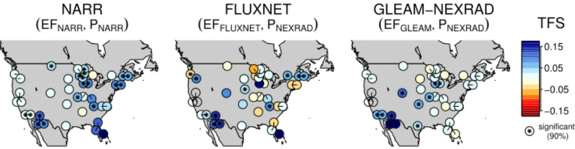
Figure


Documents relatifs
Drought propagation over northern France The model sensitivity to the initial soil moisture anomaly in southern Europe depends on the details of the atmospheric circulation
The Precipitation Inferred from Soil Moisture (PrISM) near real-time rainfall product: evaluation and comparison.... Edouard Belin, bpi 2801, 31401 Toulouse cedex
(points) and the model initial estimations (solid line). Analysis of a) root zone soil moisture and, b) vegetation biomass, using the simplified 32. 1D-VAR method for 2001 to
The forma- tion of graupel also affects the distribution of cloud and pre- cipitation in the Kananaskis Valley (Fig. 6, fourth column). In NO_GRPL, the ice cloud extends up to KES,
Lag–correlation analysis between precipitation (rain) and CPW: with precipitations of the individual measurements from the four rain–gauge stations (green), the average (blue), and
The co-variability analysis of the two SMPC relationships indicates that spatial and temporal effects of soil moisture on afternoon precipitation in the North African region do not
At high-northern latitudes, both molecules were locally enriched by a factor of 7 to 9 in a limited zone comprised between 1 and 0.1 mbar and from 50 ◦ N to the pole. Because of
Pour la première alternative de choix de structures (classes de résistance du ciment de 42,5 MPa et 52,5 MPa ne nécessitant aucune opération d’entretien), nous avons développé
