HAL Id: tel-00007478
https://tel.archives-ouvertes.fr/tel-00007478
Submitted on 22 Nov 2004
HAL is a multi-disciplinary open access
archive for the deposit and dissemination of sci-entific research documents, whether they are pub-lished or not. The documents may come from teaching and research institutions in France or abroad, or from public or private research centers.
L’archive ouverte pluridisciplinaire HAL, est destinée au dépôt et à la diffusion de documents scientifiques de niveau recherche, publiés ou non, émanant des établissements d’enseignement et de recherche français ou étrangers, des laboratoires publics ou privés.
des Pyrénées
Julien Babault
To cite this version:
Julien Babault. Dynamique de l érosion dans les chaînes de montagnes : Influence de la sédimentation de piedmont. L’exemple des Pyrénées. Géomorphologie. Université Rennes 1, 2004. Français. �tel-00007478�
THÈSE
PrésentéeDEVANT L'UNIVERSITÉ DE RENNES 1
pour obtenirle grade de : DOCTEUR DE L'UNIVERSITÉ DE RENNES 1 Mention Sciences de la Terre
Par
Julien Babault
Équipe d'accueil : Géosciences Rennes, Université de Rennes 1 École doctorale : Sciences de la matière
Composante universitaire : UFR Structure et Propriétés de la matière
Titre de la thèse :
Dynamique de l’érosion dans une chaîne de montagnes :
Influence de la sédimentation de piedmont.
L’exemple des Pyrénées
Soutenue le 2 juillet 2004 devant la commission d'examen composée de : COMPOSITION DU JURY
François Roure Rapporteur
Antonio Teixell Rapporteur
Philippe Davy Examinateur
Daniel Garcia-Castellanos Examinateur
Yves Gaudemer Examinateur
Jean Van Den Driessche Directeur de thèse
Je remercie les membres du Jury d’avoir accepté de juger ce travail réalisé à Géosciences Rennes : François Roure (Institut Français du Pétrole), Antonio Teixell (Universitat Autònoma de Barcelona), Philippe Davy (Université de Rennes 1), Daniel Garcia Castellanos (Vrije Universteit Amsterdam), Yves Gaudemer (Institut de Physique du Globe de Paris). Je te remercie tout particulièrement Jean Van Den Driessche (Université de Rennes 1) d’avoir été mon directeur de thèse.
Je remercie également Stéphane Bonnet (Université de Rennes 1) et Alain Crave (Université de Rennes 1) sans qui l’approche expérimentale du sujet n’aurait pu être possible, ainsi que Jean Jacques Kermarrec pour l’installation du dispositif expérimental et les différents étudiants qui ont passés des nuits au labo pour le bon déroulement des expériences (Polo, Laure et Sébastien). Je remercie l’efficacité du personnel de la Bibliothèque de Géosciences Rennes (Catherine, Isabelle et Alain) grâce à qui nous avons pu avoir accès à de très anciens articles et thèses. Je remercie l’accueil chaleureux de Maria Carmen et de Jose Maria à Roda de Isabena dans les Pyrénées aragonais.
Je salue tous ceux que j’ai eu la chance de connaître aux Universités de Rennes 1, de Nantes, de Brest, d’Orsay, de Barcelone, de Santiago du Chili, de Poznàn en Pologne et de
Prague pendant ces années de Fack. Un saludo especial al huevon de Cesar, al Pisco chileno y al
bueno carrete, à Blaise, Jérôme, Gosia, Rico et Youl (Pour la même raison), à Nico L. y su familia, a los Cabezones (i-e. aux Michels), à Dom et toute sa bande de potos, à Milie, à Ron et à l’Etna, à Rodolf, a Rodrigo, au Grand Sarce, a Luis, à Lůca et son aide humanitaire (Piva) à Pavel aussi faut pas oublier, au Boulvais et sa bonne humeur, à Ludo-Seb-Vin’s-Miky (Pour leur excellente prestation dans Le Film), aux Vendengers de Brest et d’ailleurs, à Gwendo et Claire et tous leurs potes, à Morgane et à la gniole à mémé, à Nico le Cambodgien, aux Concarnois et au Shogun, à Ben et sa guitare (Sauve la recherche mignon), à Cath & Flo qui je le pense ont été heureuse de connaître DéDé, à Céline-Tang-Sylvie-Christelle-Emilio-Dante-Fernando…, à Kerry et son violon fou, à Armel et Adara Daéko et pour finir à Katia notre drone et ma colloc. Je remercie très sincèrement le Bigorneau (Et le Rock’n Roll) lieu de détente et d’amusement, notamment lors des derniers mois d’achèvement de ce travail.
L’étude de la dynamique de l’érosion des chaînes de montagnes ne prend généralement pas en compte l’influence de la sédimentation de piedmont. Or le remplissage des bassins d’avant pays est le plus souvent caractérisé par des séquences de comblement, entraînant une élévation du niveau de base des rivières qui drainent les chaînes. L’objectif de ce travail est de montrer dans quelle mesure la dynamique du relief est perturbée par la sédimentation de piedmont. La démonstration s’appuie sur l’analyse de l’évolution de la morphologie des Pyrénées, dont les stades précoces sont préservés par d’épais dépôts détritiques sur le versant sud, et qui est caractérisée par une pénéplanation miocène dont les reliques aujourd’hui culminent à près de 3000 m. L’évolution proposée est testée à travers une modélisation expérimentale sur l’influence de la sédimentation de piedmont sur la dynamique d’un relief en surrection.
A
bstract
Most studies concerning erosion dynamics in mountain chains do not take into account the influence of piedmont sedimentation. Foreland basins are yet filled in with marine to continental sequences, inducing the base-level rise of streams that drain the mountain chains. This work intends to show how much the piedmont sedimentation disturbs relief dynamics. It is based on the analysis of the morphological evolution of the Pyrenees, whose early stages are preserved by thick detrital deposits on the Pyrenean southern side and which is characterized by applanation during the Miocene. Current remnants of the resulting peneplain reach near 3000 m at their highest point. The suggested evolution is compared with the results of an experimental approach concerning the influence of the piedmont sedimentation on dynamics of an uprising relief.
Introduction
11. Évolution morphologique des Pyrénées
191.1. Influence de la sédimentation de piedmont sur la dynamique de l’érosion, les Pyrénées 21
Article : Origin of the highly elevated Pyrenean peneplain 23
1.2. Sur l’âge de la connexion de l’Ebre à la Méditerranée : modélisation numérique 71
Article : Does the Ebro river connect to the Mediterranean before the Messinian Salinity Crisis? 73
1.3. Annexes : Données géophysiques bibliographiques, cartes et illustrations de l’évolution géologique et morphologique des Pyrénées 89
2. Influence de la sédimentation de piedmont sur la dynamique d’une
topographie en surrection : approche expérimentale
1212.1. Objectifs et méthodologie 123
2.1.1. Les objectifs 123
2.1.2. L’approche expérimentale 125
2.1.3. Dispositif utilisé dans cette étude : caractéristiques techniques 129
2.2. Résultats expérimentaux 134
2.2.1. Dynamique globale, Article : Influence of piedmont sedimentation on erosion dynamics of an uplifting landscape: an experimental approach 137
2.2.2. Dynamique locale 155
2.2.3. Influence d’un changement de condition aux limites (bords libres à sédimentation de piedmont) : aplanissement syn-soulèvement 165
2.3. Discussion-conclusion des résultats expérimentaux 175
2.4. Annexes :Planches photographiques, coupes et profils 179
Conclusion
191Introduction
La morphologie des chaînes de montagnes résulte de la compétition entre les processus tectoniques, qui épaississent la lithosphère et soulèvent la surface des continents, et les processus d’érosion et de transport, qui soustraient la matière et l’exportent via le réseau de drainage vers les avant-pays des chaînes. La figure 1 est due au dessinateur Reiser (1978) et résume l’idée que l’on se fait communément de la vie d’une chaîne, même si les critères utilisés ici sont particuliers : les chaînes jeunes sont élevées et disséquées, les chaînes
anciennes sont de faible altitude et présentent un relief1 doux. Cette vision qui confine à un
anthropomorphisme géologique tel que le suggère le dessin de Reiser, suppose que les chaînes s’aplanissent par « l’usure du temps », autrement dit par l’action de l’érosion à long terme. Ce processus est résumé par le modèle de Davis publié pour la première fois en 1889 sous le titre « The geographical cycle » (Figure 2) : suivant ce modèle, l’aplanissement d’une chaîne sous l’effet de l’érosion correspond à la chute de son altitude en même temps qu’au lissage de sa topographie.
Dans les zones climatiques tempérées, les réseaux fluviatiles jouent un rôle primordial
dans la dynamique des reliefs en raison de leur potentiel érosif énorme et de leur fonction de transport des sédiments. La loi physique qui gouverne l’érosion fluviatile relie la quantité d’érosion (E) à la pente locale (S) et au flux d’eau des rivières approché par la dimension de l’aire drainée amont (A) suivant une relation du type (Howard and Kerby, 1983):
,
n
m S
A E∝ ×
m et n étant des constantes positives.
Dans cette relation, l’effet de la tectonique est de modifier la pente régionale, donc les pentes locales (Ahnert, 1970; Montgomery and Brandon, 2002) (Figures 3a et 3b). Le climat quant à lui influe sur le flux d’eau et donc sur l’aire drainée amont. A climat constant, lorsque la pente régionale diminue, le potentiel érosif des rivières diminue également et les processus d’érosion des versants prennent le pas sur l’incision des rivières. En d’autres termes, une diminution de l’altitude d’un relief s’accompagne de la pénéplanation à terme de celui-ci.
Plusieurs processus sont à l’origine de la surrection de la surface terrestre, le plus « efficace » et spectaculaire étant l’épaississement de la lithosphère, consécutif à la tectonique des plaques, en particulier à la collision entre continents. Les chaînes de montagne dont il est question dans cette thèse se situent à la surface des continents et sont issues de la tectonique des plaques. Pour aplanir une chaîne de montagnes, au sens de Davis, il existe a priori deux possibilités : soit éliminer la racine de la chaîne, en d’autre terme ramener la lithosphère à son épaisseur initiale, soit « plomber » cette racine de telle sorte qu’elle tire vers le bas la chaîne. Il faut alors envisager un refroidissement de cette racine entraînant une augmentation de la densité des roches à travers des transformations minéralogiques.
En ce qui concerne la première hypothèse, on sait depuis une vingtaine d’années que les grandes chaînes de montagnes issues de la collision entre les continents finissent par s’effondrer sous l’effet conjugué de leur poids et du ramollissement de leur racine crustale (e.g. Molnar and Tapponnier, 1978; Gaudemer et al., 1988) (Figure 4). L’épaississement crustal qui était à l’origine de leur haute altitude se trouve annihilé et cette dernière diminue drastiquement. Ainsi la diminution de l’altitude des grandes chaînes ne peut être rapporté uniquement à l’action de l’érosion à long terme, mais est également due à un processus tectonique. Néanmoins, le fort flux de chaleur lié à l’épaississement initial persiste bien longtemps après l’effondrement, ce qui a pour effet, via la densité anormalement faible de la croûte et du manteau chauds, de maintenir ces chaînes « effondrées » à des altitudes anormalement élevées en regard de l’épaisseur de leur lithosphère (Figure 5). Par exemple, la Province du « Basin and Range » dans l’ouest des Etats-Unis, qui s’étend sur près de 1000 km en est-ouest et résulte de l’effondrement gravitaire de la Cordillère Nord-américaine au cours du Cénozoïque (e.g. Coney and Harms, 1984), a une altitude moyenne de 1750 m et des reliefs persistant jusque près de 4000 m alors que la croûte est revenue à une épaisseur moyenne de l’ordre de 30 km et que le flux de chaleur en surface est de l’ordre de 80 mW/m2
soit 60% supérieur à celui d’une lithosphère « normale » (Figure 6). (Il est à noter que lorsqu’il existe une racine mantellique sous une chaîne, l’instabilité convective dans le manteau qui l’englobe entraîne le détachement de cette racine froide et dense, et son remplacement par du manteau chaud et « léger » causant une nouvelle surrection de la chaîne par compensation isostatique sans épaississement crustal supplémentaire (Houseman and McKenzie, 1981; England and Houseman, 1989). La diminution de l’altitude d’une telle chaîne sera liée, là encore et outre le retour à une épaisseur normal de la croûte, au refroidissement du manteau.
Figure 2: « The geographical cycle » de Davis (1889). Après un soulèvement d’une pénéplaine (A), le relief augmente (B-D) puis diminue (D-F) pour tendre vers un aplanissement proche du niveau de la mer correspondant à la topographie initiale (F). Il s’agit d’un cycle d’érosion comme le défini Davis. Si la nouvelle pénéplaine est soulevée à son tour, un deuxième cycle prendra naissance (G).
Figure 3a: Relation entre les vitesses d’érosion et la pente moyenne pour les Monts Olympiques (Etats-Unis), chaîne active (Montgomery and Brandon, 2002).
Figure 3b: Compilation des vitesses d’érosion en fonction du relief local (un équivalent de la pente moyenne) pour des chaînes de montagnes inactives (ronds blancs) et pour des chaînes de montagnes actives (carrés noirs ; Alpes, Himalaya, Nouvelle Zélande, Monts Olympiques, Denali en Alaska, Taiwan) (Montgomery and Brandon, 2002). Le relief local est calculé au sein d’une cellule mobile de 10 km de diamètre (Ahnert, 1984) qui correspond à l’espacement entre les drains et les crêtes principaux.
Un autre effet de l’effondrement gravitaire est de modifier drastiquement la morphologie de la chaîne initiale. L’amincissement vertical de la lithosphère épaissie s’accompagne d’un étirement horizontal qui se traduit par le développement d’une série de horst et graben (Figure 4). Leur structure en « bassins et chaînons montagneux » (« basin and range ») et leur grande dimension font que le drainage de ces domaines étirés est le plus souvent endoréique, les produits de l’érosion des chaînons étant piégés dans les bassins immédiatement adjacents. Il en résulte un lissage progressif de leur topographie, les « hauts » s’érodant et s’abaissant, les « bas » se remplissant et s’élevant relativement. Un processus similaire a été invoqué en contexte compressif pour expliquer la formation de hauts plateaux, tel que le Tibet (e.g. Meyer et al., 1998). Ainsi l’effondrement gravitaire des chaînes, combiné à l’érosion, peut avoir un effet identique à celui de l’action de l’érosion seule à long terme telle qu’envisagée par le modèle de Davis. Il reste néanmoins que le retour à une altitude proche du niveau de la mer est dans le cas du processus d’effondrement gravitaire lié au refroidissement (lent) de la lithosphère.
Figure 4: Effondrement gravitaire d’une chaîne (D’après Gaudemer, 1986)
Après épaississement, l’effondrement gravitaire d’une chaîne entraîne la diminution de son altitude moyenne par amincissement de la croûte. Le modèle d’évolution proposé pour la province du « Basin and Range » (États-Unis) implique une diminution de l’altitude moyenne de 5000 à 2500 m après l’effondrement des Rocheuses Américaines. A l’inverse, l’intrusion de croûte inférieure ductile sous le bassin d’avant-pays (qui équivaut à un épaississement) augmente son altitude. Ce processus peut expliquer l’altitude élevée actuelle du plateau du Colorado.
A l’appui de la seconde hypothèse, Fischer (2002) remarque que l’altitude moyenne d’une chaîne rapportée à l’épaisseur de sa racine crustale est plus faible pour les chaînes anciennes que pour les chaînes récentes (Figure 7). Elle en conclue que les racines des chaînes anciennes sont plus denses que celle des chaînes récentes en raison du refroidissement avec le temps des premières. Suivant cette hypothèse « l’enfoncement » de la chaîne revient à un rehaussement de son niveau de base. Si l’altitude du niveau de base augmente, alors le potentiel érosif des rivières qui draine la chaîne diminue entraînant un lissage progressif de la topographie, de la même manière que dans le modèle de Davis.
Figure 5: Modèle physique expliquant la diminution d’altitude depuis 4000 m à plus de 1000 m suite à l’effondrement gravitaire des Rocheuses américaines (D’après Sonder et al., 1987)
Figure 6: Topographie de la province du « Basin and Range » et des Montagnes Rocheuses dans le sud-ouest des Etats-Unis. (D’après Eaton, 1987)
Figure 7: “Comparison “of surface topography to crustal root thickness, crustal root buoyancy, and crustal root temperature for young and old collisional mountain belts. a, Ratios (R) of mountain surface relief (h) to crustal root thickness (m) as a function of the time since collision ceased. b, R values as a function of time since the last major thermotectonic event in the region. c, Differences between crustal root and mantle density that best fit observed Bouguer gravity anomalies, assuming the seismically constrained shape of the crustal root and allowing a single value for upper crust density to vary. Error bars are 95% confidence limits. TP, Tibetan Plateau; TS, Tien Shan; AN, central Andes; WA, western Alps; CR, Carpathians; EA, eastern Alps; PR, central Pyrenees; BR, Brooks range; CN, Cantabrian mountains; VK, Verkhoyansk mountains; NU, northern Urals; CU, central Urals; SU, southern Urals; SA, southern Appalachians; CA, central Appalachians; AP, Appalachian Plateau; LL, Lachlan Orogen; NN, Namaqua–Natal Orogen; GA, northwest Grenville Orogen; TH, Trans-Hudson Orogen; FS, Svecofennian Orogen. d, Temperature at the Moho for a 45-km-thick crust from analytical and finite difference cooling models. Analytical calculations cool from a geotherm parameterized by initial surface heat flow (q 0) and crustal heat production (A) to an infinite time geotherm with lower heat flow (q f) but the same A value; q f of 50mWm22 and A of 0.8mWm23 (dotted lines); q f of 45mWm22 and A of 0.7mWm23 (short dashed lines); q f of 40mWm22 and A of 0.6mWm23 (long dashed lines). In each case q 0 values of 70mWm22 and 65mWm22 correspond to the hotter and cooler initial geotherm, respectively. Initial thermal lithospheric thicknesses are 60–90 km and final thicknesses are 190–230 km. In the onedimensional finite difference calculation (solid line) a starting geotherm (q 0 of 70mWm22 and A of 0.7mWm23) over a half-space was allowed to cool freely given continuous constant crustal heat production. For cooling since 320 Myr ago or later, finite difference cooling rates are comparable to the analytical calculation with the same q 0 and A, but slightly slower. Over longer times, the finite difference model continues to cool to unreasonably low heat flow and large lithospheric thickness, and is not shown. Conductivity in all cases is 2.6Wm21 8C21, and mantle potential temperature is 1,300 8C with an adiabatic gradient of 0.3 8C km21. These calculations are not meant to replicate the temperature history of specific orogens. Rather, they are intended to show that significant cooling is possible over 200–300-Myr timescales.”
Comparaison entre les relations existant entre l’altitude moyenne d’une part, et l’épaisseur, la flottabilité et la température de la racine crustale pour les chaînes jeunes et anciennes respectivement. (D’après Fischer, 2002)
Ainsi, la diminution de l’altitude des chaînes suivant les modèles considérés fait appel soit à l’érosion seule à long terme, soit à la combinaison de l’érosion et d’un processus thermique à long terme, soit à la combinaison entre érosion, processus tectonique à cours terme, et processus thermique à long terme. Dans les deux premiers modèles, le lissage concomitant de la topographie des chaînes est directement lié à leur diminution d’altitude. Dans le cas de l’effondrement gravitaire il faut y ajouter le piégeage des produits d’érosion à l’intérieur de la chaîne. Aussi la surface d’aplanissement d’une chaîne dans les deux premiers modèles correspondra à une surface d’érosion, alors qu’elle sera mixte, surface d’érosion et surface de dépôt dans le troisième modèle. Quoiqu’il en soit ces trois modèles supposent une diminution de l’altitude des chaînes et un lissage concomitant de leur topographie, correspondant au terme d’aplanissement tel qu’utilisé initialement par Davis (1889).
Cette notion d’aplanissement est toujours d’actualité, au point que l’observation de reliques d’une telle surface en haute altitude est considérée comme symptomatique de la surrection ultérieure d’une pénéplaine initiale, ou encore du rajeunissement d’une chaîne érodée. Dans ce dernier cas la cause de ce nouveau soulèvement peut être complètement indépendant de la tectonique à l’origine de la chaîne.
Ainsi l’une des caractéristiques majeures de la chaîne des Pyrénées, reconnue depuis longtemps, est la présence de reliques de surface d’aplanissement culminant à plus de 2000 m (e.g. Penck, 1894; Mengel, 1910; Sorre, 1913; Panzer, 1926; Astre, 1927; Nussbaum, 1931; Boissevain, 1934; Pannekoek, 1935; Birot, 1937; Goron, 1941; De Sitter, 1952; Calvet, 1994) (Figure 8). Ces surfaces ont toujours été interprétées comme la marque d’un soulèvement d’autant de cette chaîne depuis le Mio-Pliocène alors que la tectonique compressive pyrénéenne était finie (e.g. De Sitter, 1952). Une telle interprétation suppose un aplanissement des Pyrénées au cours de l’Oligocène-Miocène, puis une nouvelle surrection dont la cause reste énigmatique, qu’elle soit tectonique ou thermique. Il est à noter qu’une surrection de 2000 m des Pyrénées nécessiterait dans l’hypothèse tectonique un épaississement crustal de l’ordre de 12 km. S’il existe bien une racine crustale actuellement sous les Pyrénées, le Moho s’enfonçant jusqu’environ 50 km (cf. annexe 1, p91), il est très peu probable que cette racine se soit constitué à partir du Mio-Pliocène, aucune trace de tectonique compressive d’ampleur n’ayant été enregistré depuis cette époque. De même aucune trace de processus de type délamination lithosphérique, entraînant une variation drastique de densité, n’est observée telle que par exemple une augmentation du flux de
Figure 8: Surface d’aplanissement dans la Zone Axiale des Pyrénées à 1900 m (Plan de Beret) à la limite entre les bassins versants de la Noguera Pallaresa et de la Garonne.
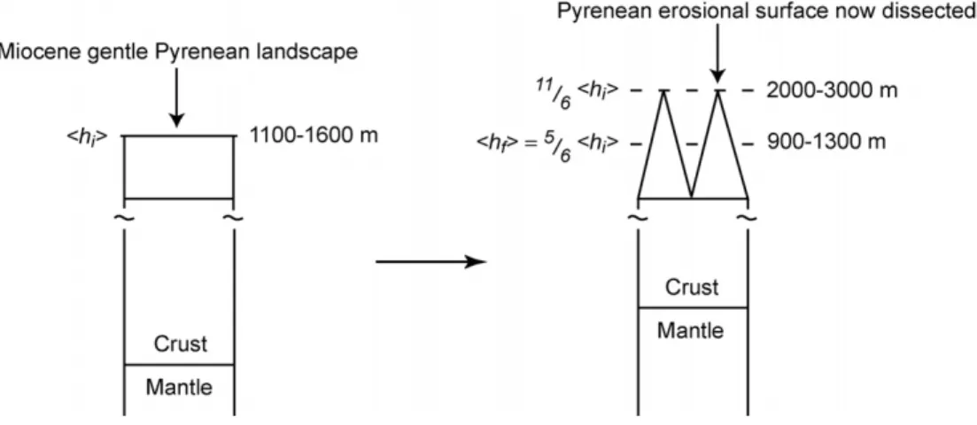
England et Molnard (1990) remarquent que le soulèvement post-tectonique de 2000 m de la chaîne pyrénéenne dans son ensemble, tel que suggéré par De Sitter (1952)à partir de l’altitude actuelle des reliques d’une surface d’aplanissement, est nécessairement surestimée. Cette surface miocène étant aujourd’hui très largement disséquée, l’altitude moyenne de la chaîne n’a pu que diminuer depuis cette époque. En revanche, si la répartition de l’érosion est très hétérogène, comme le suggère la présence de ces reliques, l’altitude de celles-ci doit s’élever par compensation isostatique (Molnar and England, 1990) (Figure 9). La présence de telles surfaces d’érosion en altitude dans les chaînes pourrait alors simplement s’expliquer par l’hétérogénéité de l’érosion et sa compensation isostatique. Dans le cas des Pyrénées, suivant le modèle de Molnard et England (1990), la présence de telles reliques entre 2000 m et 3000 m d’altitude supposerait une altitude moyenne de l’ordre de 1100m à 1600 m de la chaîne avant sa dissection post-miocène, soit du même ordre de grandeur que l’altitude moyenne actuelle (1500 m), ce qui impliquerait l’absence plus qu’improbable d’érosion depuis le Miocène (elle devrait se situer entre 900m et 1300m). Outre le fait que l’altitude initiale de la surface d’aplanissement serait déjà relativement élevée suivant le modèle de Molnard et England (1990), celui-ci peut expliquer une fraction de l’altitude actuelle des reliques de cette surface, mais ne rend pas compte de sa totalité.
Figure 9: Schéma montrant l’influence d’une érosion hétérogène, compensée isostatiquement, sur le relief. (modifié d’après Molnar and England, 1990).
i
h est l’altitude moyenne initiale, est l’altitude moyenne après l’érosion hétérogène de la surface initiale.
L’érosion hétérogène permet le soulèvement des pics de
f h
6
11 de tandis que l’altitude moyenne h est
inférieure à l’altitude moyenne initiale , de
i
h f
i
h 56.
Le cas des Pyrénées n’est pas unique et le problème s’est également posé depuis très longtemps aux géographes, géomorphologues et géologues dans les Rocheuses américaines (Keefer, 1970; Blackstone, 1975; Scott, 1975; Tweto, 1975). Aussi l’existence de surfaces d’érosion planes en haute altitude dans les chaînes n’est pas un problème fortuit mais pose celui fondamental de la dynamique de l’érosion des chaînes sur le long terme.
Les chaînes sont ou ont été bordées par des bassins d’avant-pays qui se développent ou se sont développés initialement, pour la plupart, sous l’eau avant d’émerger progressivement au fur et à mesure que la chaîne grandit. Ainsi le remplissage sédimentaire de ces bassins d’avant-pays correspond généralement à des séquences de comblement. Cette évolution est d’autant plus favorisée que ces bassins, pour une raison ou une autre, deviennent endoréiques. C’est par exemple le cas du bassin de l’Ebre au sud des Pyrénées. Si on définit le niveau de base d’un relief donné à un instant donné comme étant la limite entre la zone en érosion et la zone en dépôt, le passage d’une sédimentation marine à une sédimentation continentale dans l’avant-pays traduit une surrection du niveau de base de la chaîne. Une autre caractéristique remarquable de la chaîne des Pyrénées sur son flanc sud est l’accumulation très importante de dépôts détritiques qui « progradent » vers l’intérieur de la chaîne et dont la surface atteint actuellement près de 2000 m (Figure 10a et 10b). Là encore, une progradation
Les trois modèles d’aplanissement des chaînes discutés précédemment, et en particulier celui de Davis, associent à des degrés divers la diminution de l’altitude d’une chaîne au lissage de sa topographie, le niveau de base de la chaîne restant identique depuis sa surrection jusqu'à sa destruction dans la mesure où il correspond au niveau de la mer (et en négligent bien entendu les variations eustatiques). L’hypothèse de ce travail est à l’inverse : elle suppose que le niveau de base de la chaîne s’élève progressivement en raison de l’accumulation des produits de l’érosion au pied de la chaîne. Si la surrection de la chaîne s’arrête, alors le potentiel érosif des rivières diminue, entraînant le lissage de la topographie en altitude. Ainsi suivant cette hypothèse, et contrairement aux trois modèles évoqués précédemment, le lissage de la topographie, s’il s’accompagne d’une certaine diminution de l’altitude de la chaîne, ne nécessite pas une chute de l’altitude jusqu’à un niveau proche de celui de la mer. L’ambition de ce travail est de montrer que les chaînes de montagnes tendent à « s’aplanir » en altitude parce que la sédimentation au niveau de leur piedmont inhibe progressivement leur érosion et d’en tirer les conséquence sur la dynamique de l’érosion des chaînes en général.
Figure 10a: (Haut) Exemple de comblement d’une paéotopographie éocène par des dépots conglomératiques (la Pobla de Segur, Aragon).
A la Pobla de Segur, sur la bordure sud de la Zone Axial, les sediments détritiques grossiers culminent à 1500 m et reposent vers le nord en onlap sur les turbidites et calcaires plissés du Crétacé. (Bas) Coupe géologique correspondante (D’après Reille 1970; 1971).
Figure 10b: Les falaises de Los Riglos sur la bordure nord du bassin de l’Ebre (nord de Zaragoza).
Les conglomérats du Miocène inférieur (falaises ocres) subhorizontaux buttent contre les calcaires Crétacé et Eocène déformés qui chevauchent le bassin d’avant pays de l’Ebre (front sud-pyrénéen). Les conglomérats atteignent une altitude de 1100 m.
Pour tenter de démontrer cette hypothèse, ce travail s’appuie d’une part sur l’analyse de l’évolution morphologique des Pyrénées, en particulier de son flanc sud, et, d’autre part, sur une approche expérimentale de la modélisation de l’influence de la sédimentation de piedmont sur la dynamique de l’érosion d’une zone en soulèvement. Le mémoire est en conséquence organisé en deux parties.
La première comprend deux articles soumis. Le premier s’intéresse, à travers l’exemple des Pyrénées, au mode de développement de surfaces d’aplanissement en relation avec la sédimentation de piedmont, en particulier au niveau du bassin d’avant-pays que constitue le bassin de l’Ebre. Le second est plus spécifiquement consacré au problème de la connexion du réseau de drainage de ce bassin, endoréique pendant une grande partie du Cénozoïque, à la Méditerranée et ses conséquences sur la morphologie actuelle du versant sud des Pyrénées.
La seconde partie comprend un article soumis qui concerne l’étude expérimentale des interactions entre la sédimentation de piedmont et la dynamique de l’érosion d’une zone en
Figure 11: L’aplanissement d’une topographie en surrection à l’équilibre stationnaire est rendu possible par un changement de conditions aux limites depuis une topographie sans sédimentation de piedmont à une topographie entourée d’une sédimentation de piedmont (Expérience P5).
R
ÉFÉRENCESAhnert, F., 1970, Functional relationships between denudation, relief, and uplift in large mid-latitude drainage basins: American Journal of Science, v. 268, p. 243-263.
—, 1984, Local relief and the height limits of mountain ranges: American Journal of Science, v. 284, p. 1035-1055.
Astre, G., 1927, Le bassin Néogène de Bellver: Bull. soc. Hist. natur. Toulouse, v. LVI, p. 231.
Bates, R.L., and Jackson, J.A., 1980, Glossary of Geology: Falls Church, Virginia.
Birot, P., 1937, Recherches sur la morphologie des Pyrénées orientales franco-espagnoles [Doctorat Ès Lettres thesis]: Paris.
Blackstone, D.L., 1975, Late Cretaceous and Cenozoic History of Laramie Basin Region, Southeast Wyoming: Geol. Soc. Am. Mem., v. 144, p. 249-279.
Boissevain, H., 1934, Etude géologique et géomorphologique de la vallée de la haute Sègre: Bull. soc. Hist. natur. Toulouse.
Calvet, M., 1994, Morphogénèse d'une montagne méditerranéenne : les Pyrénées orientales [Doctorat d'Etat thesis]: Paris, Université de Paris I Panthéon-Sorbonne.
Coney, P.J., and Harms, T.A., 1984, Cordilleran metamorphic core complexes: Cenozoic extensional relics of Mesozoic compression: Geology, v. 12, p. 550-554.
Davis, W.M., 1889, The geographical cycle: Geogr. J., v. 14, p. 481-504.
De Sitter, L.U., 1952, Pliocene uplift of Tertiary mountain chains: American Journal of Science, v. 250, p. 297-307.
Eaton, G.P., 1987, Topography and origin of the southern Rocky Mountains and Alvarado Ridge, in Coward, M.P., Dewey, J.F., and Hancock, P.L., eds., Continental
Extensional Tectonics, Volume 28, Geological Society Special Publication. England, P., and Houseman, G.A., 1989, Extension during continental convergence, with
application to the Tibetan Plateau: J. Geophys. Res., v. 94, p. 17,561-17,579. England, P., and Molnar, P., 1990, Surface uplift, uplift of rocks, and exhumation of rocks:
Geology, v. 18, p. 1173-1177.
Fischer, K.M., 2002, Waning buoyancy in the crustal roots of old mountains: Nature, v. 417, p. 933-936.
Gaudemer, Y., 1986, Mécanismes de la déformation intracontinentale dans l'Ouest des Etats-Unis [Doctorat thesis], Institut de Physique du Globe de Paris et Université de Paris VII.
Gaudemer, Y., Jaupart, C., and Tapponnier, P., 1988, Thermal control on post-orogenic extension in collision belts: Earth and Planetary Science Letters, v. 89, p. 48-62. Goron, L., 1941, Les Pré-Pyrénées ariégeoises et garonnaises. Essai d'étude morphologique
d'une lisière de montagne [Doctorat thesis]: Toulouse, Faculté des Lettres, Université de Toulouse.
Houseman, G.A., and McKenzie, D.P., 1981, Convective instability of a thickened boundary layer and its relevance for the thermal evolution of continental convergent belts: J. Geophys. Res., v. 86, p. 6115-6132.
Howard, A.D., and Kerby, G., 1983, Channel changes in badlands: GSA Bull., v. 94, p. 739-752.
Keefer, W.R., 1970, Structural Geology of the Wind River Basin, Wyoming: Geol. Surv. prof. Pap. US., p. 495-D.
Mengel, O., 1910, A propos des paliers des vallées des Pyrénées-Orientales. (réponse à M. de Martonne): Bull. Soc. géol. France, v. 4è série, t. X, p. 427.
Meyer, B., Tapponnier, P., Bourjot, L., Métivier, F., Gaudemer, Y., Peltzer, G., Guo, S., and Chen, Z., 1998, Crustal thickening in Gansu-Qinghai, lithospheric mantle subduction, and oblique, strike-slip controlled growth of the Tibet plateau: Geophys. J. Int., v. 135, p. 1-47.
Molnar, P., and England, P., 1990, Late Cenozoic uplift of mountain ranges and global climate change : chicken or egg ?: Nature-London, v. 346, p. 29-34.
Molnar, P., and Tapponnier, P., 1978, Active tectonics of Tibet: J. Geophys. Res., v. 83, p. 5361-5375.
Montgomery, D.R., and Brandon, M.T., 2002, Topographic controls on erosion rates in tectonically active mountain ranges: Earth and Planetary Science Letters, v. 201, p. 481-489.
Nussbaum, F., 1931, Sur les surfaces d'aplanissement d'âge tertiaire dans les Pyrénées-Orientales et leurs transformations pendant l'époque quaternaire, C. R. Congr. int. Géog., Volume II: Ttrav. de la Section II: Paris.
Pannekoek, A.J., 1935, Evolution du Bassin de la Têt dans les Pyrénées Orientales pendant le Néogène: Ultrecht.
Panzer, W., 1926, Talentwicklung und Eiszeitklima in nord-östlichen Spanien: Abhandl. Senckenberg. naturf. Ges., v. 39.
Penck, A., 1894, Studien über das Klima Nordspaniens während der jungeren Terciärperiode und der diluvialperiode, in Erdkunde, Z.d.G.f., ed.: Berlin.
Reille, J.L., 1970, Mise en évidence de paléoreliefs de 2000 m de dénivelée, fossilisés et enterrés par les formations continentales de l'Eocène supérieur, sur le versant sud des Pyrénées centrales (région de la Pobla de Segur, Province de Lérida, Espagne): C. R. Ac. Sc. Paris, v. 270, p. 1861-1864.
—, 1971, Les relations entre tectorogénèse et sédimentation sur le versant sud des Pyrénées centrales d'après l'étude des formations terciaires essentiellement continentales [Doct. Etat Sci. thesis]: Montpellier, USTL.
Scott, G.R., 1975, Cenozoic Surfaces and Deposits in the Southern Rocky Mountains: Geol. Soc. Am. Mem., v. 144, p. 227-248.
Sonder, L.J., England, P.C., Wernicke, B.P., and Christiansen, R.L., 1987, A physical model for Cenozoic extension of western North America, in Coward, M.P., Dewey, J.F., and Hancock, P.L., eds., Continental Extensional Tectonics, Volume 28, Geological Society Special Publication.
Sorre, M., 1913, Les Pyrénées méditerranéennes: Paris.
Tweto, O., 1975, Laramide (Late Cretaceous-Early Tertiary) Orogeny in the Southern Rocky Mountains: Geol. Soc. Am. Mem., v. 144, p. 1-44.
L’étude de l’évolution de la morphologie des Pyrénées est présentée sous forme de deux articles et une série d’annexes qui complètent certains points discutés dans ceux-ci.
Le premier article propose un modèle de lissage du relief des chaînes en relation avec la sédimentation de piedmont qui permet d’expliquer la présence dans les Pyrénées des célèbres surfaces d’érosion à faible relief en haute altitude. Il s’appuie sur l’analyse de la topographie actuelle et sur l’étude de l’histoire géologique des Pyrénées.
Dans un premier temps nous analysons la morphologie actuelle des Pyrénées, incluant en particulier les caractéristiques des hautes surfaces à faible relief et celles du réseau de drainage qui les incise.
En nous appuyant dans un second temps sur les témoins du remplissage du Bassin de l’Ebre sur le versant sud des Pyrénées et leurs relations avec ces surfaces, remarquablement bien préservées dans les parties centrales et orientales des Pyrénées (Encantats, Cerdagne), nous discutons l’influence de la sédimentation de piedmont sur la dynamique de la morphologie pyrénéenne.
La présence sur le versant nord de surfaces identiques, à des altitudes comparables, nous amène à discuter l’influence relative de la nature du drainage, endoréique ou exoréique, des bassins d’avant pays d’Aquitaine et de l’Ebre, et de la capacité des rivières à transporter les produits d’érosion issus de la haute chaîne, sur l’évolution de la morphologie des Pyrénées, depuis l’Éocène jusqu’à l’actuel.
Le deuxième article concerne plus précisément l’âge de la connexion de l’Ebre à la Méditerranée, considéré comme un point crucial de l’évolution du paysage sud pyrénéen. La démonstration s’appuie sur une comparaison de l’histoire géologique de l’Ebre avec celle des autres rivières méditerranéennes, en particulier en regard de leur réponse respective à la chute dramatique du niveau de la Méditerranée au cours de la crise messinienne. La modélisation numérique de la dynamique de l’érosion fluviatile à cette époque montre que le bassin de l’Ebre n’est connecté à la Méditerranée qu’à partir du Pliocène.
1.1. Influences de la sédimentation de piedmont sur la
dynamique de l’érosion, les Pyrénées
Origin of the highly elevated Pyrenean peneplain
Julien Babault1, Jean Van Den Driessche1, Stéphane Bonnet1, Sébastien Castelltort2 and Alain
Crave1
1 Géosciences Rennes, Université de Rennes1, UMR CNRS 6118, Rennes, France
2 ETH Department of Earth Sciences, Sonneggstrasse 5, CH-8092 Zurich, Switzerland
Origin of the highly elevated Pyrenean peneplain
Julien Babault1, Jean Van Den Driessche1, Stéphane Bonnet1, Sébastien Castelltort2
and Alain Crave1
1 Géosciences Rennes, Université de Rennes1, UMR CNRS 6118, Rennes, France
2 ETH Department of Earth Sciences, Sonneggstrasse 5, CH-8092 Zurich, Switzerland
Abstract
Peneplanation of mountain ranges is generally considered as resulting from long term erosional processes that smoothes relief and lower elevation near sea-level. Therefore peneplain remnants at high elevation in mountain ranges are used to infer post-tectonic surface uplift. Such an interpretation has been proposed for the Pyrenees where high elevation, low relief erosional surfaces rose up to more than 2000 m. Because the Pyrenean foreland basins are filled with very thick continental deposits, which have buried early jagged landscape, we challenge this hypothesis by remarking that relief applanation does not necessarily require elevation lowering. We propose an alternative interpretation in which piedmont aggradation of detrital sediment that comes from the erosion of the high chain induces the rise of the base-level of the range, therefore reducing strongly the erosive efficiency of the drainage system and resulting in the progressive smoothing of the relief. Such a process allows a high elevation (HE), low relief erosional (LR) surface to develop at the scale of the range. In the Pyrenees, occurrence of HE, LR remnants does not imply a post-tectonic uplift, but is due to the dissection of the initial Miocene HE, LR surface by the recent drainage system, the erosive activity of which being enhanced by global climate change from the Late Pliocene onward.
1.
Introduction
Following the definition of Davis [1889], Bates and Jackson [1980] define in their Glossary of Geology the term “peneplain” as “a low, nearly featureless, gently undulating land surface of considerable area, which presumably has been produced by the processes of long-continued subaerial erosion, almost to base level in the penultimate stage of a humid, fluvial geomorphic cycle. They specify that “peneplain” also denotes “such a surface uplifted to form a plateau and subjected to dissection”. This later definition derives from numerous works which have interpreted the occurrence of highly elevated, more or less flat, erosional surfaces in mountain ranges throughout the world as remnants of originally low peneplains, later uplifted and now dissected by the recent drainage network [De Sitter, 1952; Keefer, 1970; Blackstone, 1975; Scott, 1975; Tweto, 1975]. In this interpretation peneplanation is thus viewed as a lowering of mean surface elevation and concomitant relief subduing. On the other hand, the occurrence of planation surfaces at high elevation in mountain belts is one of criteria used to infer their surface uplift and is at the heart of the current debate between the late Cenozoic uplift of modern mountain belts through the world and global climate change [e.g. England and Molnar, 1990; Molnar and England, 1990; Peizhen et al., 2001].
A very striking feature of the Pyrenees morphology is the presence of highly elevated, low relief, erosional surfaces hereafter referred to as HE-LR surfaces, that were extensively described since the beginning of the last century by numerous geomorphologists and geologists [Penck, 1894; Mengel, 1910; Sorre, 1913; Panzer, 1926; Astre, 1927; Nussbaum, 1931; Boissevain, 1934; Pannekoek, 1935; Birot, 1937; Goron, 1941; De Sitter, 1952; Calvet, 1994]. Late Miocene overlying continental deposits provide an upper limit age for these surfaces [Birot, 1937; Roca, 1996]. Following previous works [Boissevain, 1934; Birot, 1937; Goron, 1941] De Sitter [1952] wrote that “admirably preserved post-tectonic erosional levelling surfaces witness to the original low altitude of the folded chain and to later elevation”. In other words, in de Sitter’s [1952] view, the present-day morphology (and elevation) of the Pyrenees is unrelated to the Palaeogene alpine tectonics that led to crustal thickening in the Pyrenees. To explain the Pyrenean HE-LR surfaces, he invoked a Pliocene upheaval contemporary with a phase of tangential compression, though he could not document it. Indeed, there is no evidence of tangential deformation during Pliocene times that could have produced the ca 12 km of crustal thickening necessary to induce the 2000m of
Pliocene uplift invoked by De Sitter [1952] and more recent works [Calvet, 1985; Brunet, 1986; Briais et al., 1990; Calvet, 1994]. An alternative explanation [Brunet, 1986] would have been to consider that the Palaeogene lithospheric root of the Pyrenees was removed from the Neogene, inducing Pliocene uplift. However, the tomographic study of [Souriau and Granet, 1995] shows evidence for the still occurrence of a lithospheric root down to 100 km of depth beneath the Pyrenees. In addition, Vacher and Souriau [2001] have recently shown that the Pyrenean relief is currently overcompensated at crustal level, requiring the presence of a dense crustal root that could be achieved by the transformation of lower crust into the eclogite facies.
England and Molnar [1990] observe that the 2000 m uplift of the Pyrenees, as inferred by De Sitter [1952] from the remnants elevation of the applanation surface, is overestimated. As this Miocene surface is currently highly dissected, the mean elevation of the chain has necessarily decreased since this epoch, whereas the remnants elevation increased due to isostatic compensation. Following Molnar and England’s model [1990], the current remnants elevation, between 2000 m to 3000 m, would require a mean elevation of the Pyrenees of 1000 m to 1600 m respectively, before post-Miocene dissection, that is, in the same order as the current mean elevation of the chain (1500 m) implying no erosion since the Miocene that is unrealistic (Figure 1). Besides the fact that the Miocene elevation of the applanation surface would be already high, isostatically compensated erosion as described by the Molnar and England’s model could not account for the whole elevation of the HE-LR surfaces in the Pyrenees, even less that it requires deep valley incision near sea level which is not the present case.
In summary, we believe that the interpretation following which the HE-LR surfaces of the Pyrenees indicate that the chain was lowered and peneplaned before the Pliocene and that this peneplain was later uplifted from the Pliocene onward is wrong. The fundamental reason underlying this misinterpretation is the mistake of equating the destruction of relief with a lowering of the earth’s surface, which is just the same mistake as equating the generation of relief with surface uplift as stressed by England and Molnar [1990].
We will argue here that, under certain conditions, the rise of the mountain range base-level due to massive alluvial sedimentation in foreland basins can considerably reduce the erosive efficiency of the drainage network in the mountain range, resulting in the development of a
We first describe and analyze the present-day characteristics of the morphology of the Pyrenees. In a second step we review the morphologic evolution of the chain since the Eocene with regard to its southern flank, which allows us to propose a model for the development of the HE-LR erosional surfaces. We then discuss the timing of the dissection of the HE-LR surfaces with a particular attention to the capture of the Ebro river by the Mediterranean which has been assumed to have strongly influenced the present morphology of the southern flank. Finally we extend the model developed for the southern flank to the entire chain. Our conclusions support the view that global climate exerts a strong control on mountain morphology.
2.
Geomorphology of the Pyrenees
2.1. General characteristics
The Pyrenees are a linear mountain range approximately orientated East-West and of around 450 km in length (Figure 3). Its width ranges from 100 km in both the eastern and western parts to 160 km in the central part. The mean elevation in the Axial Zone is about 2000 m in an area of 200 km long and 20 km wide (Figure 4A). Elevation of the peaks ranges around 3000 m, the Pico de Aneto in Aragón (central Spanish Pyrenees) being the highest summit with 3404 m of altitude. The Pyrenees are flanked by two low-elevation (300-500 m) foreland basins, the Aquitaine plain to the North and the Ebro basin to the South. The transverse profiles (Figure 5) show a slight asymmetry: the southern flank is globally wider and has a lower slope than the northern flank. This asymmetry matches well the known structural asymmetry between the so-called North- and South-Pyrenean zones [e.g. Mattauer, 1968; Choukroune and team, 1989]. The North-Pyrenean zone is characterized by steeply dipping crustal thrusts which makes it narrow, whereas the South-Pyrenean zone is recognized for its thin-skinned tectonics style that makes it very wide with shallow deformation (Figure 3). This structural and hence morphological asymmetry can eventually be related, at lithospheric scale, to the subduction of the Spanish lithosphere beneath the European lithosphere [Choukroune and team, 1989; Roure et al., 1989].
2.2. The Pyrenean highly elevated “peneplain”
A striking feature of the morphology of the Pyrenees is the occurrence of high-elevation, low-relief surfaces (HE-LR) that have been previously interpreted as remnants of
an uplifted peneplain surface [Boissevain, 1934; Birot, 1937; Goron, 1941; De Sitter, 1952; Calvet, 1985; Brunet, 1986; Briais et al., 1990; Calvet, 1994]. By high-elevation flat surfaces, we mean a landscape with a smoothed morphology lying at about 2000 m a.s.l. (Figure 6), and which contrasts with the surrounding jagged relief of peaks and deeply incised valleys.
These remarkable erosional surfaces are located in two main areas, the Central Pyrenees (Encantats) and the Eastern Pyrenees (Aston, Andorra, around the Cerdanya Basin and the Capcir, cf. Figure 3 and Table 1).
Based on the previous studies of the last century [Penck, 1894; Mengel, 1910; Sorre, 1913; Panzer, 1926; Astre, 1927; Nussbaum, 1931; Boissevain, 1934; Pannekoek, 1935; Birot, 1937; De Sitter, 1952; Calvet, 1994] and using GIS methods we mapped these high-elevation surfaces within the Axial Zone. Their extent ranges from tens to hundreds of kilometers square, which corresponds to 10% of the surface of the Axial Zone (Table 1). Identification of HE-LR surfaces
Relief analysis has been performed within a moving circular search window over the SRTM 90 m resolution DEM. According to Ahnert [1984], best result is obtained for a diameter window of 5 km. At each point, the maximum range of elevation values within the window was determined and plotted at the centre of the window. The mean elevation of the chain has also been analysed using a moving circular search window but with a larger diameter of 30 km as in the study of England and Molnar [1990].
Figure 4A shows that maximum mean elevation is centered in the Axial Zone. The chain is not cylindrical, with its eastern part being larger than its western part as a result of more tectonic shortening in the former [Roure et al., 1989; Vergés et al., 1995; Teixell, 1998]. At the scale of the entire range, the local relief increases with the mean elevation, except in the most eastern part where a very low-relief, high-elevation, NE-SW to N-S narrow zone corresponds to the Tertiary grabens of Cerdanya Capcir and Conflent basins. When reported on the map (Figures 4B), the HE-LR surfaces described in the literature show a rather important local relief (750 m ± 250 m), yet contrasting with the rest of the high chain.
In fact, by analyzing the local slopes, these surface remnants appear as small areas (hundreds of m² to several km²) with local slopes lower than 10° and situated above 1400m of altitude (Figures 4C).
Transverse topographic profiles
Six topographic profiles perpendicular to the trend of the chain have been constructed from West to East (Figure 5A). Profiles 3 and 5 cut the main HE-LR surface remnants. Profile 4 corresponds to the surface profile of the ECORS deep seismic profile. All the profiles have the same characteristic bell-shaped geometry. As expected, the local relief values usually follow the topographic profiles, i.e. increase when elevation increases and vice versa. However, this is not true for profiles 3 and 5 (Figure 5A) where the local relief drastically decreases when the profile cuts the HE-LR surfaces. Such a decrease of local relief with increase of mean elevation is also encountered when a high plateau develops in a mountain belt (Figure 5B). This suggests that the small HE-LR surfaces encountered today in the Pyrenees may be the remnants of a much more extensive and more or less flat single surface.
2.3 Drainage network
Drainage pattern
The chain is deeply incised by transverse streams roughly orientated north-south and regularly spaced [20-30 km, Hovius, 1996] as seen on the map of figure 7.
Most of the drainage on the northern flank is directed to the Atlantic Ocean. The streams situated in the western and eastern parts of the northern flank flow directly into the Atlantic Ocean and Mediterranean Sea (e.g., the Aude and Têt rivers, figure 7) respectively. Drainage organisation is different in the central part of the northern flank where transverse streams connect to the Garonne river which then runs a long distance north-westward across the Aquitaine basin before entering the Atlantic Ocean.
The organization of the southern flank drainage is more classic with most of the transverse streams connecting to the longitudinal drainage of the NW-SE directed Ebro river which flows into the Mediterranean. Only in the most eastern part some streams flow directly toward the Mediterranean (e.g., the Llobregat river, Figure 7).
Longitudinal profiles of transverse rivers
Figure 8 shows the longitudinal profiles of the transverse streams that rise near the topographic ridgepole and that flow either directly into the Atlantic Ocean and the Mediterranean Sea or into the Ebro and Garonne rivers. Accordingly with the morphologic and structural asymmetry of the range previously described, the profiles of rivers of the
northern flank are systematically more concave and short than profiles of the southern flank (Figure 9A). This difference is to relate to the mean elevation asymmetry.
We use the method of [Flint, 1974] to determine the concavity index of rivers based on the slope/area relationships. This has been achieved for the main transverse rivers as
defined above (drainage area A > 108 m²) and for their tributaries (1.106 < A < 2.108 m²)
within the drainage basins delimited on figure 7. Within each plot in log-diagrams, two linear fits were computed to encompass most of data.
Plots of the concavity indexes measured in this way show that (1) the transverse rivers flowing on the northern flank are more concave than rivers of the southern flank (Figure 9A) as also shown on the longitudinal profiles of figure 8, (2) tributaries of similar drainage areas show similar concavities irrespective of their location on the northern or the southern flank (Figure 9B and 9C), and (3) the concavity of tributaries increases with the elevation of the tributary (Figure 9C).
2.4 The present-day morphology of the Pyrenees: Discussion
As mentioned before, morphological asymmetry at the scale of the entire chain, as revealed by mean elevation analysis, can be related to the northward subduction of the Iberian lithosphere beneath the European plate following Willett and Brandon’s model [2002]. Drainage network analysis also shows slight difference in the concavity of the main transverse rivers between the two sides of the chain. Such a difference may be related to that of the regional slope between the two flanks of the chain just at the onset of the post-orogenic decay. This will imply no significant difference in the incision rate of the main transverse rivers on the both flanks, so that the initial asymmetry is preserved.
In an alternative explanation to this general asymmetry, one can consider the influence of higher precipitation rates on the northern side than on the southern one [e.g.Hovius, 2000]. Indeed, this contrast between a very humid northern side and an almost dry southern side is a well known characteristic of the Pyrenean climate of today, and is also well documented in the meteorological survey reports [Météo-France, 1986].
However, the similarity of concavity indexes for the tributaries on both sides of the mountain range suggests no significant difference of erosional processes on both flanks and no link with particular climatic conditions specific to one or the other side. In summary, it is
One unexplained though striking feature of the Pyrenean morphology is the presence of highly-elevation, low-relief erosional surfaces, mostly situated in the Axial Zone. These surfaces are highly dissected by Quaternary glacial and fluvial erosion. While several hypotheses have been proposed to explain the presence of such surfaces, their origin can still be debated. In the following, we present geological and geomorphologic constraints from the evolution of the southern flank of the Pyrenees since the Cenozoic that allow us to draw an attempt to solve this problem by investigating the geological and morphological evolution of the southern flank of the Pyrenees since the Cenozoic. .
3.
Morphological evolution of the Southern Pyrenees during the
Cenozoic.
During early to middle Eocene times, the southern foreland basin of the Pyrenees is an E-W elongated narrow trough that was open toward the Atlantic Ocean allowing the dispersal of sediments supplied from the Axial Zone [e.g. Puigdefàbregas, 1975; Puigdefabregas and Souquet, 1986; Mutti et al., 1988; Puigdefabregas et al., 1992]. Further shortening and thickening afterwards resulted in the southward and eastward migration of the basin depocenter and the progressive deformation and exhumation of the basin northern margin. This period is characterized by both longitudinal and transverse inland drainage on the southern flank [Nijman, 1998; Vincent, 2001].
Because of coeval southward migration of the deformation and sediment supply increase, the entire basin was rapidly filled from the Late Eocene onward, entering a long period of continental sedimentation [e.g. Birot, 1937; Reille, 1971; Seguret, 1972; Riba et al., 1983]. At the same time, the initial connection with the Atlantic Ocean closed and the basin drainage became endoreic [e.g. Birot, 1937; Reille, 1971; Riba et al., 1983]. This resulted in the burying of the relief in the foreland fold-and-thrusts belt developed during the Eocene exoreic period which can be observed in a series of particularly well exposed Eocene transverse fluvial paleo-valleys filled with Eocene alluvials [e.g. Birot, 1937; Reille, 1971; Vincent, 2001] (e.g. Sierra de Sis paleovalley, figure 10A). This phenomenon was probably amplified by the fact that this former foreland fold-and-thrust belt was then transported as piggy-back sub-basins on the top of southward-propagating external thrust sheets, which enhanced subsidence and the trapping of sediments.
Coney et al. [1996] summarize well this story as follows: the southern flank “was progressively buried, back to and overlapping the southern margin of the axial zone, in up to 3 km of massive continental fluvial-alluvial deposits”. A fundamental observation is that at present, the remnants of sub-horizontal uppermost top-wedge alluvial deposits outcrop at an elevation of up to 2000 m where they merge into the HE-LR erosional surfaces of the Axial Zone [Coney et al., 1996]. The maximum elevation of these deposits is about 1100m a.s.l. along the frontal thrust of the South-Pyrenean zone (Figure 10B).
After this burying, when and why the re-excavation of the southern flank started remains debated. For most of authors [Birot, 1937; Reille, 1971; Coney et al., 1996; Garcia-Castellanos et al., 2003], re-excavation was induced by the capture of the Ebro River by the Mediterranean Sea, resulting in new exoreic drainage of the Ebro foreland basin. Miocene extensional tectonics within the Catalan chain or dramatic sea-level drop of the Mediterranean during the Messinian, or a combination of both, have been invoked to explain this capture [e.g. Nelson and Maldonado, 1990; Coney et al., 1996]. The very age of the capture depends on which of these processes is considered to have been predominant. Miocene or Quaternary climatic changes have also been considered to be of primary importance in the building of the present jagged relief [e.g. Nelson, 1990; Coney et al., 1996; Garcia-Castellanos et al., 2003]. In the following we will tentatively argue that the Ebro River was not connected to the Mediterranean before the Pliocene. In any case, the Ebro foreland basin and in particular the top-wedge basin, suffered strong erosion since the Pliocene, leaving remnants of Eocene to Miocene continental deposits all along the southern flank of the Pyrenees.
4.
How did the HE-LR erosional surfaces develop? A high-elevation
peneplanation model.
In the classical “geographical cycle” of Davis [1889], landscape maturity is reached after orogenic uplift when the valleys have reached maximum relief. Then, as degradation occurs, both relief and mean elevation are gradually reduced. At the end of the cycle, the landscape has been degraded to a surface of very low relief near base level called a “peneplain”. In others words the decrease of the mean elevation toward sea level is accompanied by a progressive smoothing of the landscape. In this model, the sea level is
further this idea by proposing that the same effect can result from a rise of base level (Figure 2). In particular, this can be expected at the front of mountain belts when foreland basins become closed and progressively filled with sediments. In such a case, endoreic drainage results in a general rise of the base level in the foreland basin and in considerable continental sedimentation. This is exactly what happens for the southern flank of the Pyrenees and the entire Ebro basin. The fluvial valleys developed on the southern flank of the Pyrenees during the period of exoreic drainage were then rapidly filled when the Ebro foreland basin became endoreic, the aggradation of sediments far inland the mountain range witnessing a large base-level rise. We will suggest here that before its recent excavation, the Pyrenean southern flank was looking like a large scale E-W elongated smoothed half-dome, at the top of which Paleozoic basement and minor Mesozoic sedimentary cover were outcropping, surrounded by Tertiary detrital sediments. We develop in the following two types of argument that led us to this conclusion.
1) The present slight difference in elevation between the Axial Zone and the top of the detrital series is inherited from the endoreic stage
The unusual slight difference between the elevation of the Axial Zone summit and the Ebro foreland basin top-wedge at present cannot be explained by the recent rejuvenation of the relief because this would assume much more erosion of the former. Indeed, the effect of recent rejuvenation can be easily distinguished when looking at the geomorphology of the Cerdanya region (Figure 11A). Cerdanya corresponds to a Miocene half-graben bounded to the south by a north-dipping normal fault zone. The graben is filled by detrital continental sediments which overlap the basement to the North. Sedimentological analysis of the basin fill reveals the development of shallow ponds and swampy zones [Roca, 1996]. All together, those observations suggest endoreic drainage of the graben. The fine-grained nature of most of deposits also suggests that surrounding summits were not very high with regard to the basin base-level. At present, the erosional surface on top of the basement shows a gentle southward dipping slope of about 10° (0.17 m/m, figure 11B) which was induced by Miocene tilting along the southern boundary fault. Therefore, this surface was subhorizontal before the Miocene. This surface is now incised by the current drainage network (Figure 11C). It consists of a main longitudinal drain, the Segre river which is flowing south-westward, and several transverse tributaries on each side of the trough. In fact neither these tributaries nor the uppermost course of the Segre River do incise strongly the sedimentary basin fill and underlying basement. Both the Segre River and the Têt river begin to incise dramatically
when they leave the Cerdanya trough at its south-western and north-eastern edges respectively. In others words, the Cerdanya trough appears as an area mostly preserved from erosion by the current rivers, the Segre and the Têt rivers, whose longitudinal profiles display huge knick points when approaching the Cerdanya trough (Figure 8 and 12). A remarkable geomorphologic feature of this area is the contrast of relief and roughness of the valley sides observed between outside and within the Cerdanya area. Where the Segre and the Têt rivers leave the Cerdanya basin and begin to form deep valleys in the basement, the valley sides become strongly incised by their tributaries (Figure 11C and 12).This results from the fact that in this area the difference of local relief between the borders of the Cerdanya basin and valley sides of the Segre and Têt is directly related to the difference of base level position in both areas.
This example can be viewed as a small-scale example of what happened at the scale of the Pyrenees (their southern flank at least) when the base level was much higher and Eocene valleys where filled with sediments. We therefore conclude that before the rejuvenation of the relief by the present drainage network, landscape in the Axial Zone was probably poorly incised and looking rather smooth because denudation was relative to a much higher base level. This implies (1) that the slight difference observed today between the mean elevation of the Axial zone and the top of the Tertiary detrital series cannot be attributed to the much more intense erosion of the Axial Zone during the recent period of relief rejuvenation, and (2) that HE-LR were already present during Miocene times.
In the Maladeta massif, Fitzegerald et al. [1999] have argued for a recent exhumation of about 2-3 km since the Late Miocene. In this area, HE-LR erosional surfaces lie between 2000 to 2600 m a.s.l., whereas the uppermost Oligocene detrital series, located 20 km farther to the south, reach an altitude of 1800 m. Maximum exhumation estimate was deduced from radiometric dating of samples located in a valley at an elevation of 1100 m. As quoted by Fitzegerald et al. [1999] “the present-day topographic form of the Pyrenees is largely a relict of the topography that formed in the Eocene and Oligocene”. Hence their estimate only refers to exhumation in relation with recent valley incision. Their conclusions therefore do not hold for the whole area, and in particular for the area where HE-LR are preserved. If their conclusions were valid for the whole area, this would imply that most of the detrital deposits of the Sis paleovalley would have been eroded. According to Vincent [2001], only 400 m were eroded on the top of the Sis paleovalley since the Oligocene-Miocene. Finally,
rejuvenation of the southern flank, including the dissection of a previous highly elevated peneplain, which reinforces the idea we develop here.
2) The base-level rise as a cause for relief decrease between the Axial Zone summits (mean of peaks elevations) and the top of the detrital series.
There is no doubt that the base-level of the Pyrenean southern flank has dramatically increased since the closure of the Ebro basin. Huge discharge of continental detrital sediments, especially conglomerates, has back-stepped toward the chain, onlapping previously deformed basement. Conglomerates filled the paleovalleys which have developed during the exoreic period of drainage. Some of them, such as the Sis valley, were up to 800 m deep, suggesting jagged relief on the southern flank during the exoreic period. However the morphology of certain paleovalleys appears to have been controlled by large-scale folds so that the valley depth does not reflect vertical incision (Figure 10C). Moreover, the conglomerates that fill now these paleovalleys do not seem have eroded a lot their floor and their walls on which they simply lie on onlap.
But the fact that the base-level rose, does not imply that the relief between the Axial Zone summit and the top of the detrital series was decreasing, a requisite condition to smooth relief roughness. According to most authors [Seguret, 1972; Choukroune and team, 1989] the main phase of tectonic shortening in the Pyrenees occurs during Eocene times and a second minor phase develops during the Oligocene in the most external parts of the chain. So, tectonic uplift was at its paroxysm during Eocene times, and on can reasonably expect that the chain reached its maximum elevation by the end of the Eocene. In a same way, one can expect that from the Oligocene onward, the mean elevation of the chain was progressively decreasing as tectonic uplift vanished. Continuation of continental sedimentation on the top of the previous Eocene top-wedge basin shows that the local base-level of the Pyrenean southern flank was during the Oligocene and the Miocene at less as high than it was at the end of the Eocene. As the top of the sedimentary overlaps the Axial zone, if subsidence would have occurred, inducing a decrease of the local base-level elevation, it would have resulted in a same effect for the elevation of the Axial Zone. Therefore, from the Oligocene onward, the relief between the Axial Zone summit and the top of the sedimentary was most probably decreasing, a process that will strength during Miocene times as continental sedimentation still lasts. This was resulting in the progressive smoothing of the relief roughness in the Axial Zone and the development of HE-LR erosional surfaces.