Publisher’s version / Version de l'éditeur:
Journal of the Soil Mechanics and Foundations Division, 93, SM4, pp. 419-436,
1967-09-01
READ THESE TERMS AND CONDITIONS CAREFULLY BEFORE USING THIS WEBSITE. https://nrc-publications.canada.ca/eng/copyright
Vous avez des questions? Nous pouvons vous aider. Pour communiquer directement avec un auteur, consultez la première page de la revue dans laquelle son article a été publié afin de trouver ses coordonnées. Si vous n’arrivez pas à les repérer, communiquez avec nous à [email protected].
Questions? Contact the NRC Publications Archive team at
[email protected]. If you wish to email the authors directly, please see the first page of the publication for their contact information.
NRC Publications Archive
Archives des publications du CNRC
This publication could be one of several versions: author’s original, accepted manuscript or the publisher’s version. / La version de cette publication peut être l’une des suivantes : la version prépublication de l’auteur, la version acceptée du manuscrit ou la version de l’éditeur.
Access and use of this website and the material on it are subject to the Terms and Conditions set forth at
Stability of natural slopes in sensitive clay
Crawford, C. B.; Eden, W. J.
https://publications-cnrc.canada.ca/fra/droits
L’accès à ce site Web et l’utilisation de son contenu sont assujettis aux conditions présentées dans le site LISEZ CES CONDITIONS ATTENTIVEMENT AVANT D’UTILISER CE SITE WEB.
NRC Publications Record / Notice d'Archives des publications de CNRC:
https://nrc-publications.canada.ca/eng/view/object/?id=9423b1a4-170a-43fc-a151-7bbd1d5b996b
https://publications-cnrc.canada.ca/fra/voir/objet/?id=9423b1a4-170a-43fc-a151-7bbd1d5b996b
Journal of the
SOIL MECHANICS AND FOUNDATIONS DIVISION
Proceedings of the American Society of Civil Engineers
STABILITY O F NATURAL SLOPES IN SENSITIVE CLAY^
CBrl B. Crawford' M. ASCE, and William J. Eden2
INTRODUCTION
The approximations that must be made i n the analysis of a natural clay slope a r e s o questionable that actual c a s e r e c o r d s a r e essential t o the develop- ment of reliable procedures. Even c a s e r e c o r d s a r e subject t o such a variety of interpretations that, on the b a s i s of anexhaustive study of the most reliable published material, Skempton3 observed that
".
.
.from the analysis of actual s l i p s i n clay, the values of the s h e a r strength p a r a m e t e r s a s determined by conventional t e s t s do not n e c e s s a r i l y b e a r any relation t o the values which must have been operative in the clay a t the time of failure." T h i s is a useful quali- fication t o keep i n mind in evaluating p a s t and p r e s e n t c a s e records.P a r t of the uncertainty in any stability analysis is caused by the variation of s o i l p r o p e r t i e s and groundwater conditions; the m o r e inaccurate analyses, however, a r e probably the r e s u l t of i n c o r r e c t interpretation of failure in the soil tests. When the nature and r a t e of s t r e s s changes during sampling and
Note.-Discussion open until December 1 , 1967. Separate discussions should be sub- mitted f o r the individual p a p e r s in t h i s symposium. T o extend the closing date one month, a written r e q u e s t m u s t be filed with the Executive S e c r e t a r y , ASCE. This paper i s p a r t of the copyrighted Journal of the Soil Mechanics and Foundations Division, Proceedings of the American Society of Civil Engineers, Vol. 93, No. SM4, July, 1967. Manuscript was submitted f o r review f o r possible publication on J a n u a r y 20, 1967.
a P r e s e n t e d a t the August 22-26, 1966, ASCE Soil Mechanics and Foundations Divi- sion Conference on Stability and P e r f o r m a n c e of Slopes and Embankments, held a t BerFeley, Calif.
Head, Soil Mechanics Sect., Div. of Bldg. R e s e a r c h , Natl. R e s e a r c h Council, Ottawa, Canada.
' ~ e s e a r c h Officer, Soil Mechanics Sect., Div. of Bldg. R e s e a r c h , Natl. R e s e a r c h Council, Ottawa, Canada.
3 ~ k e m p t o n , A. W., "Long T e r m Stability of Clay Slopes," ~ Q o t e c h n i q u e , Institution of Civil Engineers, London, Vol. 1 4 , No. 2, 1964, pp. 75-102.
420 July, 1967 SM 4
testing a r e considered i t is not surprisirrg that conflicting interpretations of f a i l u r e can occur.
RESIDUAL STRENGTH
Skempton dealt p r i m a r i l y with insensitive, overconsolidated c l a y s and spe- cifically excluded the sensitive Leda clays of E a s t e r n Canada f r o m h i s analysis. The overconsolidated clays described by Skempton tendto expand during s h e a r , especially a f t e r the peak s t r e n g t h h a s been reached. The increasing water con- tent caused by this expansion, together withparticle reorientation, local over- s t r e s s i n g , and t i m e effects, r e s u l t s in a reduced strength a t l a r g e strains. T h i s is called the "residual" strength and i t is shown that the strength required f o r long-term stability of slopes in these clays approaches t h e residual strength. In general i t can be concluded that normaltesting of insensitive, overconsoli- dated clays r e s u l t s in peak strengths that a r e g r e a t e r than those mobilized i n nature and stability computations a r e consequently on the unsafe side.
Sensitive clays, unlike the s o i l s just described, c a n e x i s t in nature a t r a t h e r high void ratios a s a r e s u l t of t h e i r bonded s t r u c t u r e , even when they a r e substantially overconsolidated. Under increasing o r s u s t a i n e d s h e a r i n g s t r e s - s e s the bonds a r e broken and the s t r u c t u r e collapses causing a d e c r e a s e in
I
volume. If the drainage of pore w a t e r is too slow, p r e s s u r e s will build up in the water phase until the effective s t r e s s onthe failure plane approaches zero. T h i s is the s t a t e that is thought t o exist on the failure plane of a flow slide. It is not a t a l l certain, therefore, that the residual strength concept c a n be applied t o these soils.
LEDA CLAY
I
Leda clay is the name given t o the extensive deposits of sensitive clay i n the
I Ottawa and St. Lawrence River Lowlands of E a s t e r n Canada. T h i s paper will
deal with s o i l s i n the Ottawa region that a r e thought t o have been deposited i n brackish w a t e r during a l a t e glacial stage. They have a n open, flocculated s t r u c t u r e that b r e a k s down under s t r a i n t o a liquid consistency. The natural s o i l s a r e often reasonably uniform, composed of 6O%to 80% clay-sized p a r t i - cles, with a plasticity index of 30% t o 40%. Void ratios up to 2 a r e common below the drying c r u s t which usually extends t o depths of 10 f t t o 20 ft. The clays a r e relatively nonswelling and have a low s a l t content i n the pore water.
In the Ottawa region i t h a s been shown that the undrained s h e a r strength and the preconsolidation p r e s s u r e of s a m p l e s of the natural clay a r e related t o t h e i r elevation above s e a level.4 A s s u m i n g a c l a s s i c a l geological history, it is estimated that a s much a s 200ftof overburden have been removed f r o m the lower plains since the clay was deposited. The interpretation of the s t r e s s - deformation p r o p e r t i e s of Leda clay is a s u n c e r t a i n a s that of the overconsoli- dated clays described by Skempton, but f o r different reasons. The influence of r a t e of loading on r e s i s t a n c e t o one-dimensional compression5 and t o shearing 4 ~ r a w f o r d , C. B., Bnd Eden, W. J., "A Comparison of Laboratory Results with In- Situ Properties of Leda Clay," Proceedin~s, 6th International Conference on ,Soil Me- chanics, Montreal, Vol. 1, 1965. pp. 31-35.
'crawford, C. B., "Interpretation of the Consolidation Test," Journal of the Soil Mechanics and Foundations Division, ASCE, Vol. 90, No. SM5, Proc. Paper 4056, Sept., 1964.
resistance6 appears to be especially important for the normal short-term tests. It i s questionable whether parameters obtained from such t e s t s a r e reliable when applied to long-term field problems.
LANDSLIDES IN LEDA CLAY
When a bank fails it i s possible to evaluate the actual shearing strength of the soil in place, but the reliability of the evaluation i s limited by several fac- tors. The f i r s t problem i s to obtain a sufficient number of good, representative, undisturbed samples of soil in the field and to preserve them in their natural condition until they a r e installed in the testing device. Next i s the problem of carrying out an appropriate test, which simulates all the important variables encountered in the field, such a s s t r e s s path, drainage conditions, and rate of strain, and from which simple characteristic parameters can be derived. Finally there i s the problem of determining the initial slope and ground- water conditions andthe mode of failure. For a retrogressive slide in sensitive clay the initial failure i s obscured by subsequent movements.
The writers have, from time to time, investigateda number of small river bank failures in the Ottawa a r e a with uncertain results. There is evidence of many flow slides in the a r e a but only one large one has occurred in recent y e a r s and has been subject to extensive study. This recent slide and an older classical flow slide a r e described herein. Both slides a r e located in similar soils but about 15 miles apart. The recent slide occurred in 1963 in a deep ravine near Breckenridge Station, Quebec. This ravine, which cuts through a large plain below the Gatineau Hills northwest of the City of Ottawa, con- tains many landslide s c a r s and has had some bank failures in recent years. The older slide is just south of the Ottawa River and about a mile east of the Ottawa City limits. The slide is actually locatedin an old terrace of the Ottawa River a short distance west of Green Creek in an a r e a of steep banks that appear to be quite stable.
In each of the two creek valleys (Breckenridge and Green Creek) the banks were scanned on aerial photographs and the steepest and highest sections of bank were noted. These slopes were then scaled with a stereo-plotter and the more critical ones were checked in the field by stadia survey. More than 30 slopes were selected in this way for stability analyses. For a f i r s t approxima- tion each slope was reduced to a straight line and analysed with the stability coefficients developed by Bishop and M ~ r g e n s t e r n . ~ In this way the cohesion, in t e r m s of effective s t r e s s e s , required at limiting equilibrium for various assumed values of soil density, friction angle, and groundwater conditions was computed for each slope. Some of these results a r e given in Table 1. One slope, Number 9, was analyzed using Bishop's slices method on the actual ground contours and the computed c' increasedfrom 549 psf to 610 psf with the more accurate method. All of these slopes were then analyzed again using an
'crawford, C. B., "Cohesion in an UndisturbedSensitive Clay," ~ G o t e c h n i ~ u e , Insti- tution of Civil Engineers, London, Vol. 13, No. 2, 1964, pp. 132-146.
7 ~ i s h o p , A. W., and Morgenstern, N., "Stability Coefficients f o r E a r t h Slopes," GGotechnique, Insititution of Civil E n g i n e e r s , London, Vol. 10, No. 4,1960, pp. 129-150.
/
422 July, 1967 S M 4
Slope No. Slope Angle, in d e g r e e s (a) Green C r e e k A r e a Slope Height, in feet (b) Breckenridge A r e a aassumed @' = 15", rU = 0.62, Y = 100 pcf.
Required Cohesion, in pounds p e r s q u a r e foot By stability
IBM 1620, Mark I1 computers in which a more complex representation of slope was possible. The computer results a r e also shown in Table 1.
GREEN CREEK SLIDE
Description a?zd Soil Tests.-The Green Creek slide, a s shown in Fig. 1, i s a classical example of an earthflow in which approximately 30 a c r e s of upland
PIG. 1.-AIR VIEW O F GREEN CREEK SLIDE
flowed over about 70 a c r e s of lowland to a depth of 15 ft to 20 ft. The upland, which is about 100 f t higher than the lowland, appears to be a t e r r a c e left by the Ottawa River. The c r a t e r i s clearly separatedfrom the flow material by a ridge that marks the f o r m e r toe of slope.Many s i m i l a r c r a t e r s have been ob-
81rwin, W., "The Use of a Digital Computer f o r Solving Slope Stability Problems," Computer P r o g r a m No. 19, Div. of Bldg. R e s e a r c h , National R e s e a r c h Council, Ottawa, Canada, 1964, 8 pp.
424 July, 1967 SM 4
s e r v e d a few miles down-stream in the Ottawa River valley but usually all of the flowed material has been washed away. A recently obtained age determina- tion by the Geological Survey of Canada on a piece of wood f r o m beneath the apron of the slide suggeststhat i t i s m o r e than 1,000 y r old (GeologicalSurvey of Canada, No 550, 1140
+
150 y r Before Present.)C o n t o u r s at 5 f o o t i n t e r v a l s
0 100 200 300 400 500
I I I I I I
S c a l e i n feet
FIG. 2.-PLAN O F GREEN CREEK SLOPES (LOCATION INDICATED ON FIG. 1)
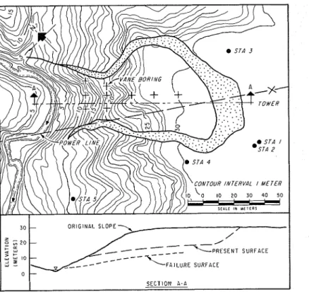
The original bank shown in Fig. 1 is oriented approximately east-west with the flow toward the north. The natural ground has been disturbed a t the south- e a s t end of the c r a t e r by the removal of borrow f o r a nearby roadfill. The contours of the p r e s e n t ground surface west ofthe c r a t e r a r e shown in Fig. 2.
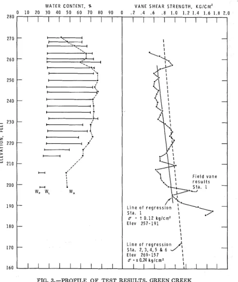
The locations of borings and field t e s t s and four of the slopes that have been studied a r e a l s o shown. Continuous samples were obtainedto a depth of 80 f t a t
Station 1 using a 54-mm, thin-walledpiston s a m p l e r ? Classification t e s t s f r o m Station 1 a r e shown in Fig. 3. Recent observations in excavations through the apron of the slide have revealed the original soil profile, including a surface peat l a y e r J O Limited t e s t s show the remoulded soil in the apron to be some-
W A T E R C O N T E N T . % 0 1 0 20 30 4 0 5 0 6 0 7 0 80 90 V A N E S H E A R S T R E N G T H , KGICM' . 2 . 4 . 6 . 8 1.0 1.2 1.4 1.6 1.8 2.0 L i n e S t a . u = E l e v L i n e o f r e g r e s s i o n E l e v 2 6 9 - 1 5 7
FIG. 3.-PROFILE O F TEST RESULTS, GREEN CREEK
what d r i e r (w = 65%) than the natural soil a t Station 1 and t o have a field vane strength equal t o about one half the natural undisturbed strength. The flowed
- - --
'Bjerrum, L., "Geotechnical P r o p e r t i e s of Norwegian Marine Clays," ~ g o t e c h n i ~ u e , Institution of Civil Engineers, London, Vol. 4, No. 2 , 1954, pp. 49-69.
' O ~ d e n , W. J., "BuriedSoil P r o f i l e under Apron of a n E a r t h flow," Geological Society of America Bulletin, 1967.
426 July, 1967 SM 4
soil appears therefore to have been reconsolidatedbutnot enough to regain i t s original strength.
In 1961, three piezometers, a t depths of 20ft, 40 ft, and 60 ft, were located on slope 33 about 24 ft downslopefromStation 3. These revealed a substantial downward flow of groundwater which had not been expected. Six additional piezometers were installed in November, 1964, and all a r e shown on the cross-section in Fig. 4. Regular measurements have indicated that maximum pore p r e s s u r e s occur in May and minimum p r e s s u r e s in August o r September. Based on the highest annual p r e s s u r e s the contours of pore-pressure ratio a r e sketched on Fig. 4. (The pore-pressure ratio i s the ratio of pore water p r e s - s u r e to total weight of soil above apoint in the ground, r , = u / y h) It i s easily observed that the downward flow of water will have a substantial effect on the effective s t r e s s e s in the ground and on the stability of the slope.
I I I I I I I I I I I I I I - - - S t a . 2 S t a . 3 - m
-
- - I l l 1 I I I I I I l l l l 100 200 D l S T A N C E , FEETFIG. 4.--SLOPE 33, GREEN CREEK
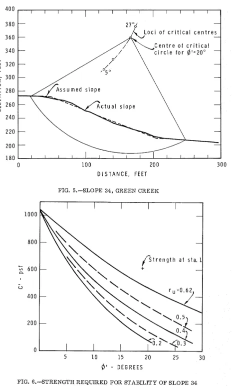
Stability Atza1ysis.-Of all the slopes in the GreenCreekarea, slopes 9 and 34 a r e closest to limiting equilibrium. Slope 34, adjacent t o the landslide c r a t e r , i s assumed to represent the slope at the location of the initial failure. The cross-section shown in Fig. 5 was therefore analyzed in detail using the pore p r e s s u r e s measured on slope 33 to estimate the maximum value of r , .
Previously 1rwin8 had prepared Bishop's method of analysis f o r an IBM 1620 computer but the program was rewritten for an IBM 360 model 50 com- puter which has since become available. This machine has a greater capacity and permitted more extensive computations. It was assumedthat the materials in the slope a r e homogeneous with c ' , $', and Y being constant, and that the pore water p r e s s u r e s can be representedby anaverage constant f o r a number of circles. Accordingly, f o r F = 1 and Y = 100 pcf, the required c' was de- termined f o r various assigned values of $' and r,. The maximum value of c' was determined for r,, = 0.62 (groundwater table a t surface and horizontal
SM 4 STABILITY NATURAL 27 I I I I I I I I I 1 / 1 1
-
- - - 7 c i r c l e f o r @ ' = 2 0 ° - - - - 1 0 0 20 0 D I S T A N C E . F E E T FIG. 5.-SLOPE 34, GREEN CREEK5 1 0 15 2 0 2 5 30
6 '
- D E G R E E S428 July, 1967 SM 4 flow) and f o r various values of
9',
the critical circle changing in each case. With r Z , = 0.2 and 0.4, the maximum values of c' were again determined for values of $J'.
The results of these solutions a r e presented in Fig. 6 and one ofthe most critical circles, with r,, = 0.62 and 9' = 20" i s shown in Fig. 5. Although this critical circle passes much below the toe of slope it has been deduced that the actual failure plane emerged near the toe because there still exists a ridge a t the lip of the c r a t e r that appears t o be the lower part of the original bank (see Figs. 1 and 2).
Based on detailed observations along slope 33, the average r , , along the critical circle through slope 34 i s estimated to be about 0.3. It i s probable that with natural forest conditions, long-term wet cycles, and higher Ottawa River levels over a thousand-year period the groundwater p r e s s u r e s would be considerably higher than a t present.'' The w r i t e r s believe that the r , , value could have been a s high a s 0.6.
FIG. 7.--STRENGTH T E S T RESULTS, GREEN CREEK
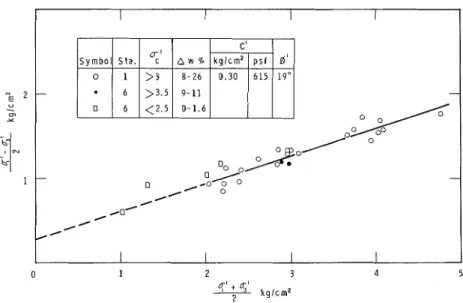
Measured Shear Streizgtk.-The undrained shear strength of the natural clay around the landslide has been measured by field vane a t Stations 1 to 6. The lines of regression and the standard e r r o r shown in Fig. 3 reveal fairly uni- f o r m soil conditions. Between El. 200 and El. 240, which cover most of the critical sliding surface, the undrained s h e a r strengthat slope 33 (Stations 2 to 6) averages about 0.9 kg p e r s q cm. At the same elevations a t Station 1 the average s h e a r strength by field vane t e s t i s about 0.8 kg per s q c m and by laboratory compression t e s t i s about 0.6 kg p e r s q cm.
Twenty-one consolidated-undrained triaxial compresssion t e s t s were c a r r i e d out on 1-1/2-in.-diam specimens, 3 in. high obtained between El. 200 and El. 240 a t Station 1. All specimens were loaded a t r a t e s of strain between 1% p e r h r and 2%per hr. The results, averaged by the method of least squares, gave c ' = 0.30 kg p e r s q c m (615 psf) and $' = 19" a s shown in Fig. 7. All of
t h e s e specimens w e r e consolidated under cell p r e s s u r e s of 3 kg p e r s q c m o r m o r e and since t h i s exceeds the preconsolidation p r e s s u r e of approximately 2.5 kg p e r s q cm, the water contents w e r e reduced in proportion t o the cell p r e s s u r e by amounts ranging f r o m 8% t o 26%. The initial w a t e r contents averaged 72% and the lowest final water content was 45%.
In 1964, a shallow boring was made between Stations 5 and 6 n e a r the toe of slope 33. Six consolidated-undrained t e s t s w e r e made on specimens a t
FIG. 8.-AIR VIEW O F BRECKENRIDGE SLIDE
average El. 231, where the preconsolidation p r e s s u r e was measured t o be about 3.5 kg p e r s q cm. F o u r of the t e s t s w e r e made a t cell p r e s s u r e s of 2.5 kg p e r s q c m o r l e s s and they gave higher than average s t r e n g t h s a s shown in Fig. 7 . Unfortunately insufficient r e s u l t s a r e available t o establish reliable s h e a r p a r a m e t e r s in t h i s range.
Strength Comparisons.-The s h e a r strength available according t o t e s t s and that r e q u i r e d f o r stability may now becompared on Fig. 6. I t will be seen that according t o the t r i a x i a l t e s t s the factor of safety would be slightly g r e a t e r than one even if the piezometric head onthe s l i p plane was equal t o the height
430 July, 1967 SM 4 of soil above i t (Y, = 0.62). Under present conditions (Y,, = 0.3) the average effective s t r e s s normal t o the slip surface i s about 1 kg p e r s q c m and the factor of safety i s equal t o about 1.6.
BRECKENRIDGE SLIDE
Descriptio?z and Soil Tests.-The Breckenridge slide occurred during a heavy rainstorm in the late evening of April 20, 1963 destroying one of the pole structures of a power line. Retrogressive slips occurredintermittently for the
FIG. 9.-PLAN O F B R E C m N R I D G E SLIDE AREA
next three days. About 30,000 cu yd of clay were involved in the slide. The upland i s a t about El. 330 and the s t r e a m bed i s a t El. 240. Unlike the Green Creek region this i s an a r e a of active sliding with visible s c a r s of relatively recent landslides. The slide i s shown in Fig. 8 and a contour plan of the a r e a before failure i s shown in Fig. 9. This plan was prepared by the Photogram- metric Research Section of the Division of Applied Physics, National Research Council from photographs taken in 1961 by the Royal Canadian Air Force. The locations of the landslide and of t e s t borings and field vane t e s t s a l s o appear on the plan.
examination of the s c a r p showed a surface cap of about 3 ft o r 4 f t of sandy silt overlying clay that appeared t o be highly stratified near the surface. Borings revealed more uniform clay extending to a depth of more than 90 ft. Continuous samples were obtained with the thin-walled piston sampler at Station 1 and vane tests were carried out a t Stations 2 to 5 (Fig. 9). The results of tests a r e shown in Fig. 10. The vane tests indicate a drying crust to a depth of about 20 f t and evidence of drying o r case hardening along the
W A T E R C O N T E N T . B V A N E S H E A R S T R E N G T H . K G I C M ~
FIG. 10.-PROFLLE O F T E S T RESULTS, BRECKENRIDGE
slope. The preconsolidation pressure a t this site is l e s s than that a t Green Creek, averaging l e s s than 2 kg p e r s q cm.
Vane t e s t s were made in the c r a t e r of the landslide at locations shown i n Fig. 9. In most of these locations the failure plane of the slide was easily indentified by a change from e r r a t i c to consistent strength measurements. This failure plane i s sketched on section A-A in Fig. 9 and i s seen to pass above the toe of slope. Vane t e s t s prependicular to this section suggests that the failure surface i s dished.
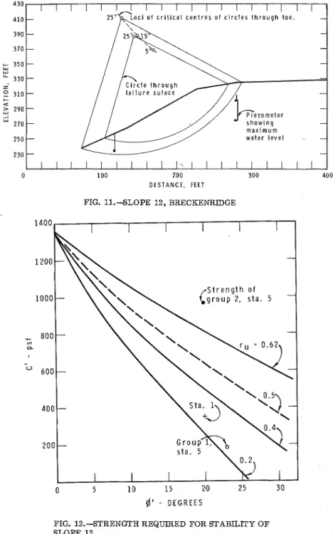
43 2 July, 1967 SM 4 FIG. 1 1 . S L O P E 12, BRECKENRIDGE 430 410 390 370 350 330 310 290 270 250 230 @ ' - D E G R E E S
-
- --
- - - - --
- - - - w a t e r l e v e l - - I I I I I I I I I l \ l I I l l I I I I -FIG. 12.STRENGTH REQUIRED FOR STABILITY OF SLOPE 12
0 100 200 300 400
Three piezometers were installed a s shown in Fig. 11 to check ground- water conditions. These revealed only a slight tendency f o r downward flow and therefore higher pore p r e s s u r e s than exist a t Green Creek. Maximum springtime values suggest anaverage r,of approximately 0.5 along the critical failure surface but i t i s thought that it was probably higher than this a t the time of failure.
Stability Analysis .-In the Breckenridge a r e a Slope 12 (Table 1) was consid- e r e d to be the most critical slope and i t i s a t the location of the landslide. Slope 12, shown a s section A-A on Fig. 9 and redrawn in Fig. 11, was there- f o r e subjected t o a comprehensive stability analysis similar to that f o r slope 34 a t Green Creek. The results of the stability analysis f o r various values of
r,
and9'
a r e shown in Fig. 12 and the critical circle f o r r , = 0.62 and9'
=FIG. 13.--STRENGTH TEST RESULTS, BRECKENRJDGE
25" i s plotted on Fig. 11. This critical circle passes through the toe of slope, but the actual failure surface, a s determined by vane borings, i s known t o be somewhat higher. Assumed failure circles passing through the actual failure surface were therefore analyzed and found t o require slightly l e s s strength f o r equilibrium than the circle through the toe.
Measured Shear Strength.-Forty-two consolidated-undrained and drained t e s t s (with decreasing lateral s t r e s s ) were c a r r i e d out on specimens obtained a t Station 1. The average failure envelope f o r these t e s t s gave c1 = 0.17 kg p e r s q cm (350 psf) and $I' = 20". Almost all of these t e s t s were substantially consolidated in the triaxial cell and consequently the structure of the soil was disturbed.
Twenty-six triaxial t e s t s were made on specimens obtainedbetween El. 230 and El. 245 a t Station 5 and most of them were tested at cell p r e s s u r e s l e s s than the preconsolidation pressure, which i s approximately 2.5 kg p e r s q c m
434 July, 1967 SM 4
(average of 12 tests) a t this elevation. The maximum deviator s t r e s s e s a r e plotted in Fig. 13. The results a r e tabulated in three groups. The f i r s t group was tested at consolidation pressures- of 2.5 t o 6 kg per s q c m and the water content was reduced f r o m 7% t o 25% depending on the pressure. These t e s t s a r e not considered t o have any direct practical value because of the distur- bance caused by consolidation. The second group was stressed l e s s than the preconsolidation pressure and resulted in higher strengths, c1 = 0.47 kg p e r s q c m (965 psf), $' = 20". The third group was tested with cell p r e s s u r e s of 0.5 to 1 kg per s q c m and a t failure the lateral effective s t r e s s was a s low a s 0.1 kg p e r sq cm. One of the disadvantages of the triaxial test i s that low lateral effective s t r e s s e s a r e inevitable in t e s t s in the low s t r e s s range and i t i s thought that this results inpremature failure. Therefore these t e s t s were given l e s s emphasis in establishing the failure envelope.
TABLE 2.-SUMMARY O F TEST RESULTS AND COMPUTED SAFETY FACTORS
Strerzgth Compavisons.-The s h e a r strengths available according t o t e s t s and that required for stability a r e compared in Fig. 12. It will be seen that the s h e a r strength p a r a m e t e r s obtained by extrapolating the strength of consolidated specimens (Stations 1 and Group 1, Station 5) a r e quite unrealistic but that t e s t s done a t p r e s s u r e s lower than the preconsolidation p r e s s u r e (Group 2, Station 5) give reasonable results. Assuming a pore p r e s s u r e ratio of 0.62 a t failure, the computed factor of safety based on Group 2 results is
1.12. For an assumed r , = 0.5 the factor of safety is 1.26.
ANALYSIS OF RESULTS
'lope
3 4
1 2
A number of simplifications have been made to a s s e s s the reliability of s h e a r strength parameters measured in the laboratory. The p a r a m e t e r s themselves have been reduced to single values of c' and $' for comparison with required values in Figs. 6 and 12. Average values for r, and f o r oh (ef-
T e s t Group 1 2 Sta' 1 1 5 5 Cell P r e s s u r e >p, > p n >pn <pn c ' 615 350 185 965 @' 1 9 20 23 20 0.62 0.3 0.62 0.5 0.62 0.5 0.62 0.5
u k
1050 2130 1290 1700 1290 1700 1290 1700 F S 1.15 1.61 0.63 0.76 0.56 0.76 1.12 1.26fective s t r e s s normal to the slip surface) were then estimated to compute the safety factors listed in Table 2.
The safety factor for Slope 34 under present groundwater condition is estimated at 1.61 on the basis of specimens which were substantially consoli- dated during the test. Tests on unconsolidated specimens from the toe of the slope suggest that the safety factor may be greater. This i s compensated by the possibility that a slope steeper and higher than Slope 34 existed at the location of initial failure of the old Green Creek landslide. Indications from other piezometers in the a r e a a r e that the downward flow of groundwater i s a general condition and this i s thought to explain the apparent present stability of the Green Creek valley.
At Breckenridge the tests conducted at cell pressures higher than the p r e - consolidation pressure gave strengths that were too low but tests carried out closer to the working s t r e s s range were quite reasonable. It i s thought that the r , existing at the time of failure was close to 0.62 and this gives a factor of safety of 1.12. That the value exceeds unity can be partly explained by the neglect of the possibility of atensioncrackfull of water at the top of the bank. Other possible reasons a r e related t o intrepretation of the shear tests and to unknown influences of progressive failure. At this time (1967) the quoted factors of safety should be considered only a s approximations because of the many simplifications that have been introduced.
Although i t was not possible to study the influence of strain rate on the sensitive samples described herein, it i s known that strength decreases with decreasing rate of strain in the overconsolidated s t r e s s level. Based on very slow loading in the oedometer, there i s reason to believe that a satisfactory minimum strength i s present in the overconsolidated region. This i s probably the value that should be used in a stability analysis.
Another factor that may have a substantial influence on a stability analysis in these sensitive soils i s the methodof test. The writers believe that failures in these soils a r e essentially undrained. Effective s t r e s s e s on the potential failure plane may be decreased rather slowly by naturally increasing pore p r e s s u r e s but when the material begins to strain the breakdown in structure causes a rapid r i s e in pore pressure and an undrained failure. It follows that the pretreatment of samples should not cause consolidation before shearing and it i s apparent from the analysis of the Breckenridge slide that s h e a r strengths measured in the working s t r e s s range a r e required.
CONCLUSIONS
These investigations suggest tentatively that an effective s t r e s s analysis of natural slopes in the sensitive clays around Ottawa will yield satisfactory results. Confidence in this approach i s limited, however, by the substantial lack of agreement between the critical failure circle and the actual failure surface. Because the actual surface i s higher than the computed surface, i t may be suggested that the frictional component i s higher than the value deduced from the laboratory tests, although other factors have to be considered. F o r example, tension cracks and fissures, known t o exist in the upper layers of soil, would have a greater influence on the strength mobilized along a shallow surface. Also, the pore p r e s s u r e s existing above the toe of slope a t the time of failure at Breckenridge were probably high, possibly high enough t o initiate
43 6 July, 196'7 SM 4
a progressive failure. The influence of the present downward gradient in the p o r e water a t Green Creek, however, h a s a stabilizing effect m o r e than enough t o compensate for seasonal p o r e p r e s s u r e s a t the toe. The influence of ground- water conditions is clearly important and failure t o m e a s u r e these conditions adequately may lead t o i n c o r r e c t a s s e s s m e n t s of stability.
ACKNOWLEDGMENTS
The preliminary a s s e s s m e n t of m o r e than 30 slopes was c a r r i e d out by K. van Dalen of Carleton University during a s u m m e r a t the Division of Building Research. E. L. Matyas and W. Irwin of Carleton University made m o r e detailed a s s e s s m e n t s during a subsequent s u m m e r appointment. The w r i t e r s a r e v e r y grateful f o r this assistance and f o r the f u r t h e r help of other colleagues a t DBR. The paper is a contribution f r o m the Division of Building Research, National R e s e a r c h Council, Canada and is published with the ap- proval of the Director of the Division.
---
I
5324 STABILITY OF NATURAL SLOPES I N SENSITIVE CLAY I KEY WORDS: soil mechanics; slopes stability; shear strength, sensitivity
clay (material);
slides
ABSTRACT: Failures of natural slopes in sensitive clays often retrogress leaving a
i
characteristic crater which i s wider than the opening in the slope. Two actual failures of this type that occurred near Ottawa, Canada a r e described and compared with stable Islopes in the same general area. One of the failures occurred several hundred years
I
ago but changes in ground water conditions since failure appear to have increased the stability of adjacent slopes in that area. The second failure, in an area of active I sliding, occurred in 1963. In each case the required strength for stability under Ivarious ground water conditions has been computed and compared with measured I I
values. It i s concluded that an effective s t r e s s analysis of these slopes yields satis-
I
factory results if tests are conducted in the working stress range and ground water I Iconditions a r e carefully measured. I I REFERENCE: Crawford, Carl B., and Eden, W. J., "Stability of Natural Slopes in I !
Sensitive Clay," Journal of the Soil Mechanics and Foundations Division, ASCE, Vol.
[
9 3 , No. SM4, Proc. Paper 5324, July, 1967, pp. 419-436. I
I