HAL Id: hal-01295795
https://hal.archives-ouvertes.fr/hal-01295795
Submitted on 31 Mar 2016
HAL is a multi-disciplinary open access
archive for the deposit and dissemination of
sci-entific research documents, whether they are
pub-lished or not. The documents may come from
teaching and research institutions in France or
abroad, or from public or private research centers.
L’archive ouverte pluridisciplinaire HAL, est
destinée au dépôt et à la diffusion de documents
scientifiques de niveau recherche, publiés ou non,
émanant des établissements d’enseignement et de
recherche français ou étrangers, des laboratoires
publics ou privés.
From leave scale to tree scale: which structural
parameters influence a simulated full- waveform
large-footprint LiDAR signal?
Cécile Antin, E. Grau, G. Vincent, S. Durrieu, M. Jourdan, Jean-François
Barczi, Yves Caraglio, Sébastien Griffon, R. Pélissier
To cite this version:
Cécile Antin, E. Grau, G. Vincent, S. Durrieu, M. Jourdan, et al.. From leave scale to tree scale: which
structural parameters influence a simulated full- waveform large-footprint LiDAR signal?. SilviLaser
2015, Sep 2015, La Grande Motte, France. pp.110-112. �hal-01295795�
From leave scale to tree scale: which structural parameters influence a simulated
full-waveform large-footprint LiDAR signal?
Cécile Antin
1, Eloi Grau
2,3, Grégoire Vincent
1, Sylvie Durrieu
3, Marion Jourdan
4, Jean-François
Barczi
5, Yves Caraglio
5, Sébastien Griffon
5, Raphaël Pélissier
11
IRD, UMR AMAP, F-34000 Montpellier, France
2 CNES, UMR TETIS, F-34000 Montpellier, France 3 IRSTEA, UMR TETIS, F-34000 Montpellier, France
4
CNRS, UMR AMAP, F-34000 Montpellier, France
5 CIRAD, UMR AMAP, F-34000 Montpellier, France
Highlights: We explored the impact of tree structural parameters on spatial LiDAR signal. We created
detailed virtual representations of forest scenes that we subsequently altered structurally and
geometrically. We simulated a large-footprint LiDAR signal on the virtual scenes. Alteration of forest
scenes impacted the metrics extracted from the backscattered waveforms up to a 136.4% difference.
Key words: virtual forest scene, plant architecture, radiative transfer, spaceborne LiDAR, simulation,
sensitivity analysis
Introduction
Light Detection And Ranging (LiDAR) technology has the potential to assess forest structural parameters and notably canopy height, wood biomass or volume, and leaf area index [1]. Although these parameters are typically estimated at the stand level, the LiDAR backscattered signal is affected by vegetation structural properties at tree level. For example, leaf clumping and leaf inclination distribution are believed to have a significant effect on the backscattered signal [2], whereas crown archetypes assumptions significantly affect the parameters derived from LiDAR return [3]. Simulation of LiDAR signal on realistic and detailed virtual representations of forest stands can be used to better understand how the LiDAR signal interacts with the different parts of a tree, which is a step towards the development of improved methods for assessing vegetation characteristics from LiDAR data.
The main objective of this work is to explore how vegetation structural parameters at a fine scale (i.e. individual tree level) impact basic metrics extracted from the backscattered waveform of a large footprint LiDAR system. LiDAR waveforms were simulated on a realistic virtual forest scene. A sensitivity analysis was conducted by altering virtual scenes to assess the impact of structural and geometrical simplifications of the tree representation on the simulated LiDAR signal and on few metrics derived from the waveforms. The results of this sensitivity analysis should provide insights into which tree structural parameters (1) precisely impact the LiDAR simulations, and (2) have to be independently estimated for the inversion of a real LiDAR waveform.
Materials and methods
We first applied an original approach to create tridimensional realistic virtual representations of maritime pine plantations by the simulation of tree development in stand (i.e., including inter-tree competition and functional relationships between branch section and supported leaf area). The resulting forest scenes, representative of a set of plots measured in the field, were validated by a comparison with forest inventory data. We then simulated a large-footprint LiDAR signal on the virtual forest scenes and their altered versions in order to test whether the modified parameters impacted the backscattered waveform.
Creation of 3D realistic virtual scenes of maritime pine plantations
The creation of the virtual forest scenes is based on the botanical knowledge of plant architectural development [4] and takes into account plant-to-plant interactions. The scenes were produced with the AmapSim software [5], available from the AMAPstudio software suite for plant architecture modelling [6]. We used forest inventory data and terrestrial LiDAR data from seven plots from the study site of St-Symphorien (France), in the Landes' forest, to calibrate age-dimension distributions of diameter at breast height (dbh), total height, height of crown base, and crown area projection. Additionally, we used published reports to calibrate age-foliage area relationships [7]. The simulations were constrained so as to fit with distribution of tree dimensions observed in the reference plots and reported in the literature.
Sensitivity analysis of a simulated LiDAR signal to vegetation structure
The 3D virtual scenes of maritime pine plantations obtained with AMAPsim were post-processed with Xplo, also available from AMAPstudio, in order to segment virtual trees according to both the nature (leaves vs. wood) and the dimensions (branch section) of their components. The realistic (i.e. non-altered) representations served as references for the sensitivity analysis. They were then altered in three different ways, while preserving tree density, canopy height and LAI of the original scenes. (1) Geometric alterations modifying the shape, size and inclination of leaves in the reference scene were conducted with Xplo. (2) A foliage voxelization was performed with DART by transforming the meshed representation of the foliage into a turbid medium and attributing to series of cubic volumes (voxels) the leaf area density of the reference scene. The leaf inclination angle distribution attributed to each voxel was either assumed to fit a predefined model (spherical, erectophile, or planophile distributions were tested) or was computed with actual angles of individual needles on the reference scene. (3) All tree components (trunks, fine, medium or large branches, and leaves) were alternatively removed to assess their specific contribution to the signal.
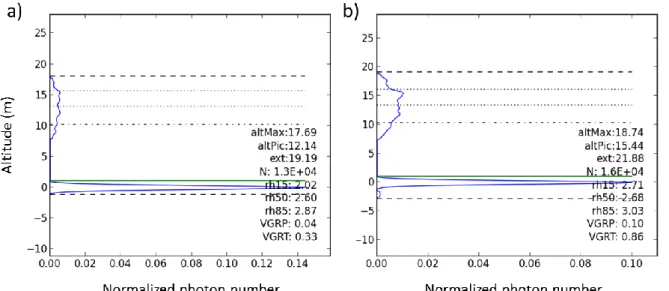
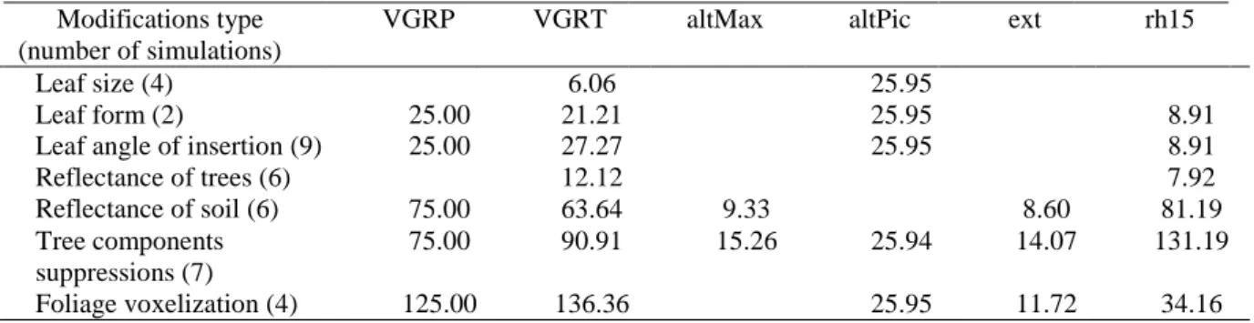
A full-waveform large-footprint LiDAR signal was simulated on these representations using DART software for radiative transfer modeling [8]. The simulated laser pulsed at 1064 nm from a distance of 500 km above the ground with an inclination of 2° from the zenithal direction. The simulated footprint measured 20 m of diameter. Eight metrics were extracted from each simulated waveform (Fig.1): altMax (difference between the signal begin and the ground peak), altPic (difference between the vegetation peak and the ground peak), ext (waveform extent), VGRP (ratio between vegetation peak and ground peak), VGRT (ratio between vegetation total area and ground total area), rh15, rh50 and rh85 (distance from the signal begin of the 15, 50 and 85 percentiles of signal intensity). They were then compared across simulations.
Results and discussion
We obtained detailed virtual scenes composed of tridimensional meshed objects with known properties for every mesh, i.e. nature, dimension, orientation, inclination. The virtual trees are botanically realistic as they render the topology and geometry of plant elementary components, and fit the distribution of tree dimensions (diameter at breast height, total height, height of crown base, crown area projection, foliage area) either measured or predicted by allometries for the reference plots. Two virtual forest scenes were selected; corresponding to two inventoried circular plots of 15 m radius of maritime pines aged 19 and 60, respectively.
Figure 1: Waveforms and associated LiDAR metrics for a detailed virtual scene (19 years old maritime pines) (a) and for the same scene with a voxelized representation of the foliage with a resolution of 1 m for the voxels (b).
The LiDAR simulations on the scene of maritime pines aged 19 showed that the less sensitive metrics were
altMax and ext (absolute prediction error ≤ 15.26%, see Table 1) whereas VGRP, VGRT and rh15 were more
sensitive to the alterations performed (absolute prediction error up to respectively 125.00, 136.36 and 131.19%). The geometric alterations had less impact on the metrics than foliage voxelization or components suppression. The foliage voxelization impacted the metrics extracted from the waveform with an effect increasing with the voxel size (25 to 200 cm). For the foliage voxelization with actual predefined leaf inclination angle distribution, the most affected metrics were VGRP and VGRT. The impact of voxelization was more important for a planophile distribution, intermediate for a spherical distribution and less important for an erectophile distribution (respectively 125, 50 and 25% for VGRP and 136.36, 54.55 and 30.30% for VGRT). The alternative suppression of tree components showed the predominant role of leaves in the simulated waveform and the minor role of
twigs and trunks. These results are consistent with the conclusions of a similar analysis on simulated small-footprint LiDAR [9].
Table 1: Maximum absolute prediction error (%) for 6 metrics extracted from simulations on altered virtual scenes (only the differences ≥ 5% are reported).
Modifications type (number of simulations)
VGRP VGRT altMax altPic ext rh15
Leaf size (4) 6.06 25.95
Leaf form (2) 25.00 21.21 25.95 8.91
Leaf angle of insertion (9) 25.00 27.27 25.95 8.91
Reflectance of trees (6) Reflectance of soil (6) 12.12 7.92 75.00 63.64 9.33 8.60 81.19 Tree components suppressions (7) 75.00 90.91 15.26 25.94 14.07 131.19 Foliage voxelization (4) 125.00 136.36 25.95 11.72 34.16
Conclusion
These results indicate that having a precise description of small branches is not of critical importance for the modeling of vegetation-LiDAR interactions, but that a detailed representation of trees performed better than a voxelized scene (turbid medium representation of the foliage) for LiDAR waveform simulations.
The substantial impact of the leaf inclination distribution on the simulated signal suggested that this parameter should be carefully parameterized in simulations and that caution is recommended for the inversion of a real LiDAR waveform. In particular, a spherical distribution hypothesis was not the most appropriate simplification in our study case.
The sensitivity analysis showed that structural and geometrical alterations of detailed tree representations (especially leaves representation) have minor impact on the simulated LiDAR signal. Identifying the right level of simplification of foliage for LiDAR (and other signals) simulation has clear practical implications as it may significantly reduce the computing time in radiative transfer simulations.
Acknowledgements
The authors acknowledge funding from the French CNES/TOSCA program. This work also benefitted from data acquired in the frame of the FORESEE project (ANR-2010-BIOE-008) granted by the French National Research Agency (ANR).
References
[1] van Leeuwen, M., & Nieuwenhuis, M. (2010). Retrieval of forest structural parameters using LiDAR remote sensing. European Journal of Forest Research, 129, 749–770.
[2] Detto, M., Asner, G. P., Muller-Landau , H. C., & Sonnentag, O. (2015). Spatial variability in tropical forest leaf area density from multireturn lidar and modeling. Journal of Geophysical Research: Biogeosiences, doi:10.1002/2014JG002774.
[3] Calders, K., Lewis, P., Disney, M., Verbesselt, J. & Herold, M. (2013). Investigating assumptions of crown archetypes for modelling LiDAR returns. Remote Sensing of Environment, 134, 39-49.
[4] Barthélémy, D., & Caraglio, Y. (2007). Plant architecture: a dynamic, multilevel and comprehensive approach to plant form, structure and ontogeny. Annals of Botany, 99: 375-407.
[5] Barczi, J.-F., Rey, H., Caraglio, Y., de Reffye, P., Barthélémy, D., Dong, Q. X. & Fourcaud, T. (2008). AmapSim: A structural whole-plant simulator based on botanical knowledge and designed to host external functional models. Annals of Botany, 101, 1125–1138.
[6] Griffon, S., & de Coligny, F. (2014). AMAPstudio: An editing and simulation software suite for plants architecture modelling. Ecological Modelling, 290, 3–10.
[7] Shaiek, O., Loustau, D., Trichet, P., Meredieu, C., Bachtobji, B., Garchi, S., & EL Houani, M.H. (2011). Generalized biomass equations for the main aboveground biomass components of maritime pine across contrasting environments. Annals of Forest Science, 68, 443-452.
[8] Gastellu-Etchegorry, J.-P., Yin, T., Lauret, N., Cajgfinger, T., Gregoire, T., Grau, E., Feret, J.-B, Lopes, M., Guilleux, J., Dedieu, G., Malenovský, Z., Cook, B.D., Morton, D., Rubio, J., Durrieu, S., Cazanave, G., Martin, E., & Ristorcelli, T. (2015). Discrete Anisotropic Radiative Transfer (DART 5) for modeling airborne and satellite spectroradiometer and LIDAR acquisitions of natural and urban landscapes. Remote Sensing, 7, 1667-1701.
[9] Romanczyk, P., van Aardt, J., Cawse-Nicholson, K., Kelbe, D., McGlinchy, J. & Krause, K. (2013). Assessing the impact of broadleaf tree structure on airborne full-waveform small-footprint LiDAR signals through simulation. Canadian Journal of Remote Sensing, 39, S60-72.