HAL Id: hal-01201997
https://hal-univ-rennes1.archives-ouvertes.fr/hal-01201997
Submitted on 16 Dec 2015HAL is a multi-disciplinary open access
archive for the deposit and dissemination of sci-entific research documents, whether they are pub-lished or not. The documents may come from teaching and research institutions in France or abroad, or from public or private research centers.
L’archive ouverte pluridisciplinaire HAL, est destinée au dépôt et à la diffusion de documents scientifiques de niveau recherche, publiés ou non, émanant des établissements d’enseignement et de recherche français ou étrangers, des laboratoires publics ou privés.
Mid Holocene vegetation reconstruction from Vanevan
peat (south-eastern shore of Lake Sevan, Armenia)
Chantal Leroyer, Sébastien Joannin, David Aoustin, Adam A. Ali, Odile
Peyron, Vincent Ollivier, Petros Tozalakyan, Arkady Karakhanyan, Fany Jude
To cite this version:
Chantal Leroyer, Sébastien Joannin, David Aoustin, Adam A. Ali, Odile Peyron, et al.. Mid Holocene vegetation reconstruction from Vanevan peat (south-eastern shore of Lake Sevan, Armenia). Quater-nary International, Elsevier, 2016, 395, pp.5-18. �10.1016/j.quaint.2015.06.008�. �hal-01201997�
Mid Holocene vegetation reconstruction from Vanevan peat (south-eastern shore of Lake Sevan; Armenia)
Chantal Leroyer 1-2*, Sébastien Joannin 3-4, David Aoustin 2, Adam A. Ali 3, Odile
Peyron 3, Vincent Ollivier 5, Petros Tozalakyan 6, Arkady Karakhanyan 6, Fany Jude 2 1 Ministère de la Culture, Sous-Direction de l’Archéologie, Paris, France
2 CNRS-UMR 6566, CReAAH, Université de Rennes 1, MCC, Rennes, France;
chantal.leroyer@univ-rennes1.fr; david.aoustin@univ-rennes1.fr;
fany.jude@gmail.com
3 CNRS UMR 5554, ISEM, Université de Montpellier, Montpellier, France;
sebastien.joannin@univ-montp2.fr; Ali@univ-montp2.fr;
odile.peyron@univ-montp2.fr
4 CNRS UMR 5276, LGL TPE, Université Lyon 1, Villeurbanne, France; 5Aix Marseille Université, CNRS, MCC, LAMPEA UMR 7269, 13094,
Aix-en-Provence, France; ollivier@mmsh.univ-aix.fr
6 Institute of Geological Sciences, National Academy of Sciences of Armenia,
Armenia; georisk@sci.am; tozalakyan@mail.ru
* Corresponding author : Chantal Leroyer ; phone number: +33 (0)2 23 23 56 23 ; complete postal address: UMR 6566, Laboratoire ArchéoSciences, Université de Rennes 1, Campus de Beaulieu, bât. 24-25, CS 74205, 35042 Rennes cedex, France, E-mail address: chantal.leroyer@univ-rennes1.fr
Abstract
A sediment core has been retrieved from Vanevan peat (south-eastern shore of Lake Sevan, Armenia), which is today disconnected to Lake Sevan thanks to an artificial shallowing of the lake. Based on 5 radiocarbon dates, Vanevan record covers the Mid Holocene (from ca. 7800 to ca. 5100 cal. BP). The Late Holocene is today absent in the peat stratigraphy due to modern peat exploitation by surface milling. This study focuses on a multi-proxies approach including pollen, charcoals and pollen-inferred climate reconstruction.
An open-land, steppic vegetation is recorded up to ca. 7700 cal. BP, followed by a more forested landscape during the Mid Holocene (up to ca. 5700 cal. BP), and ending again with an open-land vegetation (up to the record stop, i.e. 5100 cal. BP). This vegetation dynamics responds to general climate changes documented in the Near East. Whether human activities are documented since ca. 7500 cal. BP (Late Neolithic) in Vanevan, they remain marginal and are probably not affecting Vanevan area. Early Holocene dry climate, which caused the steppic environment to be widely documented through the Near East, is strongly related to low late spring precipitation
(PMay–Jun = 180 mm). Mid Holocene forested landscape and increasing lake-level
seem related to late spring precipitation (+28%), which is the main change in estimated climate parameters. This has to be linked with reinforcement of the Westerlies and less active Siberian High, which are inversely involved in the following, dry phase starting at ca. 5700 cal. BP.
Keywords: Vegetation, Fire, Climate and Human impacts, Lesser Caucasus, Mid Holocene
Running Head: Mid Holocene palaeoenvironment and palaeoclimate in Armenia 1. Introduction
Located between Black and Caspian Seas, Armenia is the most mountainous country of the Lesser Caucasus. The mean elevation is 1830 m and 75% of its area ranges from 1000 to 2500 m. Climate varies from a contrasted continental to mountainous influences. Steppic vegetation is widespread today, and only 8% of Armenia is covered by exploited and deteriorated forests (it was 18% back in XVIII century, Sayadyan, 2011), mostly concentrated in North-East and South-East (Chorbajian, 2006). The main challenge is to know if vegetation was always steppic or if a forest phase may have existed during the Holocene. Whether a forested phase is
documented during the Mid Holocene in recent studies across Georgia (e.g. Connor and Kvavadze, 2008; Messager et al., 2013), only low resolution pollen analyses (Takhtajyan, 1941; Tumanyan, 1971; Tumajanov and Tumanyan, 1973; Sayadyan et al., 1977; Sayadyan, 1978) suggest that forests once existed in Armenia. Moreover, these studies (in Russian) are not up to today’s standards (no dates or few datings on molluscs, up to 40% unidentified palynomorphs). According to Moreno-Sanchez and Sayadyan (2005), they bring indication to support the idea that broadleaf deciduous forests existed 6000 years ago around the Lake Sevan. If forested landscape was to be confirmed for the Mid Holocene, we then have to decipher the
start of deforestation and to understand respective role of human impact and/or climate change in the establishment of modern vegetation. It is of great importance in such a mountainous area where environment is harshly treated by strong human pressures and drastic climate conditions.
Whether economy starts relaying on productivity during the 8th millenary BP in
Armenia (Chataigner, 2007; Chataigner et al., 2012), it is important to underline that Early-Mid Holocene human impact is not evidenced in palaeoenvironmental data. We must rely on authors (e.g. Turner et al., 2010; Roberts et al., 2011) to state that Early Holocene human activity such as deforestation, slash and burn, over-grazing, seem to be responsible for desertification in the entire Near East. Such an area (i.e. Near East) certainly hides various stories considering longitudinal and latitudinal ranges, varying topography in-between two seas. Armenia, with its central position through Lesser Caucasus, requests for accurate studies to document past environmental changes and their drivers.
Carefully following this aim, we provide a study from Vanevan peat, which is part of Gilli wetland (Jenderedjian, 2005), located in the Sevan Lake watershed. Before Lake Sevan's artificial water-level drop for irrigation and electricity production, which began in 1933 (Gulakyan and Wilkinson, 2002), Gilli wetland was the most important inland waterfowl area in Transcaucasus Region (Jenderedjian, 2005). Therefore, Vanevan area is of major interest as a paleoenvironmental archive from the Lake Sevan’s shoreline. In the present study, we rely on hygrophyte composition changes occurring in the wetland and on a wider range to terrestrial vegetation changes in order to characterized both pacing and amplitude of fluctuations. In this way, climate reconstruction inferred from pollen assemblages and charcoal history are expected helping to discuss climate and anthropogenic forcing. Furthermore, past drivers for vegetation changes throughout the Holocene in the Near East are subject to debate between possible changes in influences of the Indian summer monsoon (Djamali et al., 2010) or of the westerlies (Roberts et al., 2011).
2. Study area
2.1. Geological setting
Vanevan peat (40°11.748 N 45°40.099 E; alt. 1919 m a.s.l.) is located south-east of Lake Sevan (1898 m a.s.l.; Fig. 1a), ca. 3.2 km from the modern shoreline (Fig. 1b). Lake Sevan is the biggest lake in Armenia. It was sizing 1257 km2 and 33.4 km3 in
2006. It is one of the highest mountainous freshwater lakes in the world. Quaternary tectonic forms this lake (Meybeck et al., 1997; Ollivier et al., 2010). Catchment area is about 5000 km2, where 28 rivers feed the lake, while the outflowing Hrazdan River
goes through Araxe River to the Caspian Sea. Higher evaporation (800 mm.year -1)
than direct precipitation (360 mm.year -1) causes a negative balance and a slow
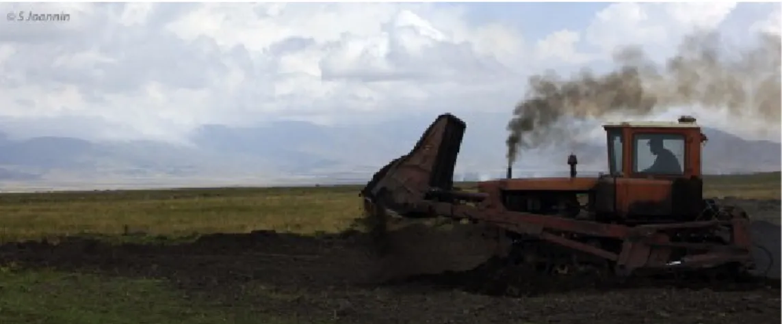
turnover (50 yrs; Meybeck, 1995). Annual precipitation in the coastal belt is between 350 to 446 mm and around 800 mm in the mountain zones (Baghdasaryan, 1958). The use of its water for agriculture and electricity production caused a water lowering (19 m) and volume lost (40%). Since then, eutrophication impacts faunal and floral in and around the lake (Lind and Taslakyan, 2005). The Gilli wetland (1500 ha), from where Vanevan peat belongs, is in alluvial-paludal area influenced by torrential activity. The lowering of the lake for irrigation and electricity, as well as field drainage for agriculture cause the peat drying, and it is currently exploited ( Tumanyan, 1971; Jenderdjian, 2005 ) by milling of surface (Fig. 2).
2.2. Present climate and phytogeography
Today’s climate is very contrasted. The Vanevan area is characterized by a mountain climate with mild summers and extremely cold and snowy winters. Dry and cold winters are controlled by Siberian Highs breaks which cause the westerlies to temporarily bring snow over the Lesser Caucasus. In summer, Saoudian Highs can break in the South and bring relatively more humid air. Rains are provided by westerlies and originate from the North Atlantic (Berg, 1950). The meteorological station of Sevan city is the closest station from Vanevan with on line data spanning a long enough time window (http://www.worldweather.org). The study zone is
characterised by a low annual temperature (3 °C on average), with a minimum in January (-8 °C on average) and a maximum in August (15 °C on average). Annual precipitation is about 500 mm with 128 precipitation days in average (Fig. 3).
Mountain-valley circulations, due to differential heating, can produce thundershower activity (particularly in late spring, i.e. May-June), while snow retards the rise of air temperature.
According to bioclimatic classification from Zazanashvili et al. (2000), Lake Sevan belongs to the South Uplands type in which Anatolian-Iranian components
predominate in the plant communities’ floristic composition. It includes two zones: hemi-xeric upper mountain forest and woodland (Quercus macranthera, Pyrus spp.,
Acer hyrcanum, Juniperus polycarpos in combination with mountain steppes; up to
2300 m) and subalpine woodlands (Quercus macranthera in combination with herbaceous vegetation; up to 2800 m). The east Caucasus type develops on the northern slope of the mountain chain (Sevan range) north-east of Lake Sevan (Fig. 1b). It includes several zones: Lower Mountain (Fagus orientalis, Carpinus
caucasica; up to 1200 m), Mesic beech forest (up to 2000 m) and Subalpine elfin
wood (Quercus macranthera, Pinus kochiana and birch in combination with subalpine herbaceous vegetation; up to 2700 m).
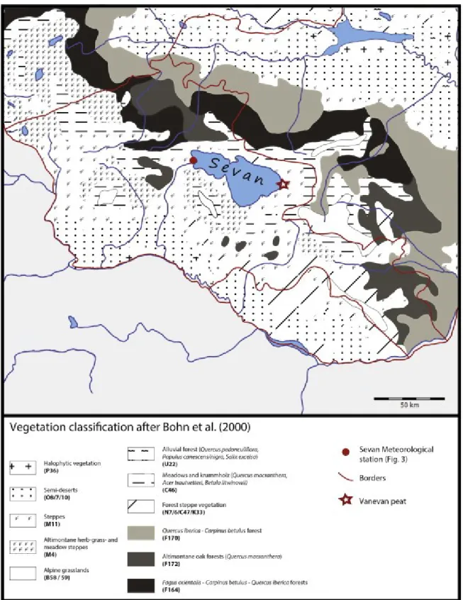
More focusing on the lake Sevan surroundings, Bohn et al. (2000) consider here a mountain semi-arid bioclimatic zone. Around Vanevan (Fig. 4), the major vegetation types are Stipa-steppes (M11: mountain type / Pre- and Transcaucasian feather grass steppes). Their composition is both highly varied and species-rich with many endemics (Table 1). To the west of Vanevan, steppe is composed of species from meadow steppes and mountain steppes (M4: Transcaucasian altimontane herb-grass- and meadow steppes). To the east of Vanevan, persists open krummholz forests and open woodlands with endemic trees species, shrubs and grasslands (C46), while alpine grasslands (B58) are present at higher altitudes. North of Lake Sevan, there are Transcaucasian colline-montane juniper open woodlands
(Juniperus polycarpos, J. foetidissima), partly in combination with Pistacia mutica-open woodlands (K33).
Considering the Vanevan peatland, today’s vegetation is dominated by sedge taxa (such as Cyperaceae, Juncaceae and Phragmites). This wetland dries up during end of summers.
3.1. Core sampling, lithostratigraphy and chronology
The coring of the Vanevan sequence was performed in 2011 using a Russian corer. A 164 cm long core was drilled, recovered in four sections (A: 0-56 cm; B: 36-92 cm; C: 72-128 cm; D: 108-164 cm) (Fig. 5).
From base to top (based on visual observations), this core contains sandy silt (164 to 150 cm), which becomes more argillaceous ca. 156 cm, organo-mineral clays
between 150 and 132 cm, organic clays between 132 and 41 cm, and peaty sediment above.
The chronology is based on five Accelerator Mass Spectrometry (AMS) 14C ages
(Table 2), performed on organic materials. Unfortunately, no datable macrofossils were found at the base, so the AMS 14C age is determined on bulk sediment
samples. Macrofossils were collected from sediment samples sieved with a 100 µm mesh screen. Radiocarbon ages were calibrated in yrs cal. BP by the Calib 7.0 software using the calibration curve IntCal13 (Reimer et al., 2009). Dates are expressed as intercepts with 2σ ranges. The age-depth model is constructed using an interpolated linear curve (Fig. 5) by the 'Clam' model developed by Blaauw (2010). 3.2. Pollen analysis
3.2.1. Pollen samples
Thirty-six samples were taken at various intervals (2 to 6 cm) across the core. For each sample, 1 cm3 of sediment was processed following the standard methods in
palynology using HF, HCl, KOH baths (Fægri and Iversen, 1989) and heavy liquid flotation using zinc chloride. After treatment, the residue was suspended in glycerol, mounted onto microscope slides and counted under a light microscope at a standard magnification of × 500 and ×1000. Two samples were sterile (at 150 and 160 cm depth).
Pollen flora was identified using photo atlases (Reille, 1992-1998; Beug, 2004) and the reference collection at University of Rennes 1. The pollen diversity is established to 108 taxa with a mean taxonomic diversity of 41 taxa. Poor in the three lower samples (18 taxa), the diversity increases at 149 and 147 cm (36 taxa) and
especially between 145 and 35 cm (38-59 taxa). It decreases at the top (24-42 taxa). A total of 26205 spores and pollen were counted with an average sum of 771 per sample (259 to 5698). So, a minimum of 151 to 1192 terrestrial pollen grains, excluding wetland plants (Cyperaceae and aquatics) and spores of pteridophytes, was counted for the poorest and the richest samples, respectively. Palynofacies (algae, microscopic charcoal and organic matter) was observed during the counting. Pollen values were calculated as a percentage of total land pollen excluding
Cyperaceae, aquatic plants and fern spores (Fig. 6) but Figure 7 presents a synthetic pollen diagram where Poaceae are also excluded. The pollen diagrams (Figs. 6-7) were produced using Gpalwin software (Goeury, 1997). Local pollen assemblage zones were identified on a visual basis and verified with cluster analyses using Past software (Hammer et al., 2001). The Pollen Indicator of Human Activities (Fig. 7) was calculated with the frequencies of Cerealia-type, Secale, Linum, Centaurea cyanus,
Papaver, Rumex acetosa, Convolvulus, Polygonum group and Plantago group
(Behre, 1981; Brun, 2011). 3. Methods
Quantitative estimates of temperature and precipitation are inferred from Vanevan pollen data with the Modern Analogue Technique ‘MAT’ (Fig. 7) which has already been tested in Armenia from the Zarishat pollen assemblages (Joannin et al., 2014). In the MAT (Guiot, 1990), the similarity between each fossil sample and modern pollen assemblage is evaluated by a chord distance. Estimates of past climatic parameters are calculated by taking a weighted average of the values for all selected best modern analogues (here 8). To reduce uncertainties in the climate
reconstruction, which often occur with steppic pollen assemblages, we have applied to the analogue selection a constraint by biomes. A biome is assigned to each modern and fossil pollen sample following a procedure based on a plant functional type–pollen data attribution Peyron et al. (1998). Winter and late spring precipitation
(Pwin, PMay–Jun; Fig. 7) are the hydrological parameters that are assumed to have the
strongest relationship with pollen data in Armenia (Joannin et al., 2014). In southern Georgia also, statistical analysis showed that rainfall was the parameter most
strongly correlated with pollen composition (Connor and Kvavadze, 2008). The temperature of the coldest month (MTCO) is reconstructed for comparison with previous studies because this variable imposes a limit on the growth of plants. To reduce the potential effect of spatial autocorrelation (Telford and Birks, 2005), we have used the same modern pollen dataset than for the Zarishat reconstruction, which include the update of the European modern pollen dataset by adding 45
surface samples from southern Georgia (Connor et al., 2004; Connor and Kvavadze, 2008). The updated dataset used here contains 3058 surface samples.
3.3. Macroscopic charcoal analysis
Macroscopic charcoal samples of 1 cm3 were taken contiguously. Samples were
soaked in a 3% (NaPO3)6 solution for a minimum of 2 days before wet sieving
through a 160-µm screen. The remaining particles were bleached in a 10% NaOCl solution to aid in distinguishing charcoal from dark organic matter. The sieving method is assumed to represent local-scale fires, i.e. 1 km from the fen (e.g. Carcaillet et al., 2001; Higuera et al., 2007). Identification, counting and area measurements of charcoal particles were undertaken using a 20x stereoscope coupled with a digital camera and image-analysis software (Regent Instruments Canada Inc.).
4. Results and interpretation 4.1. Age model
One 14C age (D-42.5 atdepth 150.5 cm) was excluded from the age-depth model
(Fig. 5), having both low organic content and large error margin (9860 ± 380; Table 2). So the age-depth model is extrapolated to the base of the core. Considering the surprising age obtained at 24.5 cm (4745 ± 35) and keeping in mind the possible effect of present-day peat exploitation by milling the surface observed at 300-400 m away from the coring site (Fig. 2), we get an extra 14C date at 10.5 cm depth.
Accuracy of this age (4580 ± 30) claims for no reversion of the sediment surface. This suggests sediment removal over the coring area. We decided to stop the pollen count at 5 cm depth. Tumanyan (1971) already mentioned such peat extraction in
Gilli area. This also caused removal of the uppermost part of the peat at his coring location.
Sedimentation rate varies from base to top. It is first 0.5 mm.yr -1 from 160 to 145 cm,
then 0.6 mm.yr -1 up to 100.5 cm. Between 100.5 and 50.5 cm, accumulation rate
increases to 0.98 mm.yr -1. Interval 50.5 to 24.5 cm includes a major lithological
change; peat accumulation causing the sedimentation rate to decrease to 0.28 mm.yr
-1. For the uppermost section, the rate increases (0.63 mm.yr -1).
Based on this age-model, the Vanevan record covers about 3000 years from ca. 7800 to ca. 5100 cal. BP. The early Holocene is absent due to sterility of basal pollen samples and late Holocene is no more available in the coring area. The average temporal resolution for the pollen analysis is estimated to 79 yrs between samples (min to max: 33 to 176 yrs between samples).
4.2. Pollen analysis 4.2.1. Pollen sequence
Five main LPAZs (Local Pollen Assemblage Zones) have been distinguished in the Vanevan pollen record (Figs. 6-7).
LPAZ Van 1 (depth: 155 – 151 cm) is recorded in the sandy silt, spanning the period from 7800 to 7740 cal. BP. It is dominated by taxa from open ground (Cichorioideae, Chenopodiaceae, Poaceae and Asteraceae) and steppic taxa such as Artemisia. Hygrophilous vegetation is scarse and only includes Cyperaceae. The Tree component is rare, essentially composed of Ephedra distachya t., Juniperus then
Pinus. Low but continuous amounts of Quercus and Ulmus are recorded. LPAZ Van
1 ends with slight increases of Cyperaceae and Quercus, while Betula appeared. LPAZ Van 2 (depth: 149 – 135 cm) is recorded in the organo-mineral clay, spanning the period from 7700 to 7470 cal. BP. This zone records a general tree expansion, where all tree taxa from LPAZ Van 1 increase (except Pinus and Ephedra distachya t.) added by appearance of numerous tree taxa such as Betula, Carpinus, Fagus,
Ostrya t., Tilia, Fraxinus, Acer, Hippophae, Alnus and Salix. Quercus is the most
dominant tree taxa, followed by Juniperus, which attains its maximum in this zone. Poaceae and Artemisia increase while Cichorioideae, Chenopodiaceae and
Asteraceae strongly decrease. Similarly to tree taxa, herbs also become richer by adding heliophilous taxa (Brassicaceae, Rumex, Polygonum, Plantago) or
hygrophytes (Sparganium, Potamogeton, Typha, Myriophyllum, Ranunculaceae, Liliaceae, Rosaceae, Filipendula). First occurrence of Cerealia-type is recorded. Subdivision into two subzones (Van 2a, depth: 149 – 147 cm and Van 2b, depth: 145 – 135 cm) highlights the lowering in amounts of Cichorioideae, Chenopodiaceae and
Thalictrum. Additionally, LPAZ Van 2 shows continuous appearance of algal taxa
such as Botryococcus and Pediastrum.
LPAZ Van 3 (depth: 131 – 100 cm) is recorded in the organic clays, spanning the period from 7400 to 6890 cal. BP. and divided into three subzones (Van 3a, depth: 131 – 125 cm; Van 3b, depth: 121 – 110 cm and Van 3c, depth: 105 – 100 cm). On the whole, Van 3 records a decreasing in Juniperus, and a maximum development of
Hippophae. Quercus is still the dominant tree taxa, along with Ulmus and Carpinus.
Noteworthy is the presence of Phyllirea-Olea and Pistacia pollen grains. Considering herbs, increases of Thalictrum and hygrophytes are recorded while cereals (Cerealia-type and Secale) are regularly seen in the pollen assemblages. Van 3a mainly shows the Quercus increase, Van 3b its decrease and Van 3c the Juniperus and Hippophae
decreaseswhile Carpinus increase.Van 3b also characterizes higher amounts of Cyperaceae and aquatic taxa, the last becoming more diversified before declining in Van 3c. Algal taxa such Botryococcus and Pediastrum are continuously present during Van 3.
LPAZ Van 4 (depth: 95 – 35 cm) is recorded in the organic clays and at the base of peat, spanning the period from 6840 to 5860 cal. BP. This period is divided into three subzones (Van 4a, depth: 95 – 85 cm; Van 4b, depth: 80 – 45 cm and Van 4c, depth: 40 – 35 cm). In overall, this period is characterized by an increasing of
Chenopodiaceae, Cichorioideae, Asteraceae and Cyperaceae along with a
decreasing of Poaceae, Sparganium and hygrophytes taxa. .More precisely, Van 4a mainly shows a slight increase in Quercus and Betula. Van 4b shows the increase in
Artemisia.Van 4c records less diversified tree taxa, but a slight increase in Carpinus
pollen amount.This subzone also records strong increase in Sparganium together with weaker increases of Typha and other aquatic taxa (Myriophyllum spicatum, M.
verticillatum, Polygonum amphibium, Lemna, Utricularia). Van 4 shows Pediastrum
algae being discontinuously present.
LPAZ Van 5 (depth: 30 – 5 cm) is recorded in the peaty sediment, spanning the period from 5680 to 5190 cal. BP and divided into three subzones (Van 5a, depth: 30 – 25 cm; Van 5b, depth: 20 – 10 cm and Van 5c, depth: 5 cm). On the whole, this zone is marked by a decrease in tree taxa both in quantity and in percentage abundance. A strong increase in Poaceae and ferns is recorded while previously described aquatics decrease. Cyperaceae remains rather abundant, although its percentage is strongly varying. As the Poaceae pollen grain may indistinctively being product by grass or Phragmites, that is to say by less or more local vegetation, pollen diagram can be observed again after excluding Poaceae (Fig. 7).In this case,
Quercus remains stable, while Juniperus and Carpinus increase as well as Artemisia
and Chenopodiaceae. In Van 5a, pollen indicators of human activities decrease. Van 5b shows slight increases of Pinus and decreases of Juniperus and Carpinus.
Aquatics almost disappear and ferns develop. Van 5c shows a decrease in Poaceae amount and the fern maximum (together with sporangium being observed in this sample). Van 5 shows algal taxa disappearance.
4.2.2. Pollen-based climate reconstruction
For all samples, 8 modern analogues have been selected for the climate
reconstruction. These modern analogues are mainly located in southern Georgia and in Armenia cold steppes for the Early/Mid Holocene climate reconstruction (ca. 7800 to 5800 cal. BP), and they are located in Georgia, Armenia, Soviet Union and Tibetan for the late Holocene (ca. 5700 to 5200 cal. BP) The climate reconstruction appears robust for all the sequence: the adopted threshold is 65.59, and the Chord distance which measures the quality of the modern analogues is low, except for two samples corresponding to 7800 cal. BP.
During the 2700-year-long record, the mountain climate of Sevan seems to be well reconstructed and the values reconstructed for the coldest month are ~ 2 °C (for the Mid-Holocene to 5750 cal. BP) higher than today’s values (Fig. 7). The first part of the record (from ca. 7700 to 5750 cal. BP) is climatically stable (even if a decreasing temperature trend can be evidenced) and shows higher values than the second part (from ca. 5750 cal. BP onwards). It is noteworthy that the shift, which took place at ca. 5700 cal. BP resulted in a considerable change of the climate conditions, both in terms of precipitation (ΔPMay-Jun = -120 mm) and temperature (ΔMTCO = -4 °C). When
considering the seasonal parameters for precipitation, it appears that the winter precipitation is stable and plays a minor role. In contrast, an increase is evidenced in late spring precipitation at the beginning of the Mid Holocene (ca. 7700 cal. BP); then precipitation strongly decreases at 5700 cal. BP.
4.3. Macroscopic charcoal analysis
Charcoal particles are found down to 128 cm in the core. As there are no charcoals at the base of the sequence, the fire activity provides a 2200-year-long record (Figs. 7-8). Unfortunately variations in CHAR (Charcoal Accumulation Rate) with
unpredictable background component prevent to reconstruct fire episodes.
Figure 8 also includes length-to-width ratio against time. Ratio values < 0.5 indicate that fires mostly burned sedge and grassland vegetation (Aleman et al., 2013).
Therefore, two phases are shown by concentration of charcoal and by length-to-width ratio. First, from base (i.e. 128 cm) to ca. 5750 cal. BP (40 cm), no fire activity is detected and length-to-width ratio values are dispersed. Second, abundant charcoals from ca. 5750 to 5400 cal. BP show four burning peak maxima and a plateau in ratio values from 40 cm onward.
5. Discussion
Today located on the verge of Lake Sevan (1898 m a.s.l.), Vanevan sequence (1919 m a.s.l.) is retrieved from the littoral zone, which is of estuarine type. Indeed, before the artificial lowering (ca. 20 m), which recently occurred, this marsh was connected to Lake Sevan (Sayadyan, 2002; Jenderedjian, 2005). Considering its past, Vanevan area may have experienced various situations from being part of the lake (but never under deep water) to a suspended peat relatively independent. These have
implication on the pollen types, which are trapped in the sediment. Whether pollen from ligneous taxa are usually favoured in the pollen record compared to herbaceous taxa (e.g. Sugita, 1993; Sugita et al., 1999), highly diversified hygrophilous taxa claim for a more local component in pollen origins, although long-distance transported tree pollen certainly exist.
5.1. A steppic environment until 7700 cal. BP
The lowermost part of the sequence is dominated by detritic sedimentation (sandy silt) and by herbs: Cichorioideae, Poaceae and Chenopodiaceae. High amounts of Cichorioideae can be considered as taphonomically biased as this pollen grain is less easily corroded than other grains (e.g. Bottema, 1975; Hall, 1981; Havinga, 1984; Lebreton et al, 2010). According to Havinga (1984), dominance of Cichorioideae is associated with low taxa diversity and inconsistencies in the pollen assemblage. At Vanevan, taxa diversity is indeed low, but pollen assemblage consistency appears robust as several steppic taxa are observed (such as Artemisia, Chenopodiaceae, Caryophyllaceae, Carduaceae, Rubiaceae …), together with trees such as Ephedra
distachya t., and E. fragilis t.. Contemporaneously, similar pollen assemblages
existed at Zarishat fen (Joannin et al., 2014) and Lake Paravani (Messager et al., 2013). Therefore, Cichorioideae are widespread before ca. 7700 cal. BP, although their values are probably reinforced by corrosion.
These samples show open vegetation, dominated by steppe meadows
(Compositeae, Chenopodiaceae, Poaceae and Artemisia). Trees are probably absent from direct surroundings as attested by rare tree pollen grains and rather low prevalence of Pinus and Juniperus, which are long-distance transported pollen grains (Connor et al., 2004). Vanevan area (i.e. 1919 m a.s.l.) is not occupied by aquatic vegetation as only few Cyperaceae grow. Sandy-silt sedimentation, which refrains spreading of hygrophytes, can indicate velocity of moving waters or more likely ephemeral fens on alluvial deposits (as observed in the higher elevated Zarishat fen, Joannin et al. 2014). In the first case, relatively deep water coincides with wet
conditions pointed out by Roberts et al. (2001; 2011) for the Early Holocene. This conclusion is based on paleohydrological records, cave carbonates and marine cores, and extends over both East Mediterranean and Middle East (from Greece to Iran). However, Sayadyan (1978, 2009) and Sayadyan and Aleshinskaya (1991) reported a progressive increasing of water level based on mollusc assemblages from Norashen site (northwest of Sevan Lake). This increase starts after a low-stand (terrace located at 1861.5–1865.5 m a.s.l.) during the estimated time interval 10000 to 8000 cal. BP. It attains a high-stand (estimated between 8000 to 6000 cal. BP; (terrace located at 1919.4–1923.4 m a.s.l.) during which water level starts to decrease at around ca. 7000 cal. BP (according to online NOAA data). If these studies are not up to today’s standards, they bring useful indication to corroborate the possibility of a very high water level before 7700 cal. BP.
Open-land vegetation observed south east of Sevan Lake matches similar pollen assemblages from Lesser Caucasus and Anatolian area: in Armenia (Shamb-2 travertine, Ollivier et al., 2011; Zarishat, Joannin et al., 2014), in Georgia (Paravani, Messager et al., 2013), in Turkey (Van Lake, Van Zeist et Woldring, 1978, Wick et al, 2003; Eski Acigol, Roberts et al., 2001) and in Iran (Lake Urmia, Bottema, 1986, Djamali et al., 2010; Zeribar, Van Zeist and Bottema, 1977; Mirabad, Stevens et al., 2006). Similar open-land vegetation are also confirmed in pollen records in a
synthesis from the Balkan peninsula to Southern Siberia (Wright et al., 2003), in lowland Bulgaria (Filipova-Marinova et al., 2013; Connor et al., 2013), in the Black Sea marine record 22GC3 (Shumilovskikh et al., 2012), in Caspian Sea (e.g. Leroy et al., 2013, 2014), in Central Asia at lake Sonkul (Mathis et al., 2014) and in the
Eurasian synthesis including different biotic (e.g. pollen and diatoms) and abiotic proxies (e.g. δ18O and lake-level) developed by Chen et al. (2008).
Steppic meadows indicate dry climate conditions, corroborated by Ephedra pollen occurrences (Wick et al., 2003). Such dry climate during Early Holocene (ca. 12000-8000 cal. BP) is observed by all previously cited authors; Chen et al. (2008) extended it to all Arid Central Asia (ACA). Several authors (Van Zeist et Bottema, 1977; Bottema, 1986; Wick et al., 2003; Connor and Kvavadze, 2008; Djamali et al., 2008; Litt et al., 2009; Joannin et al., 2014) agree to link this arid climate to low spring precipitation, which maintains up to ca. 8000-7500 cal. BP. Vanevan record confirms this general climate scenario as pollen-based climate reconstruction records low May-June precipitation (PMay–Jun = 180 mm) compare to annual precipitation (Pann = 635
mm) (Figs. 7 and 8). Causes of such conditions are still under debate. According to Djamali et al. (2010), it is due to a typical Mediterranean continental climate (mainly winter-dominated precipitation) in which spring precipitation is reduced or eliminated by northward shifts of the inter-tropical convergence zone (ITCZ) and subtropical anticyclonic belt that prevented the eastward penetration of the North Atlantic and Black Sea lows., While Chen et al. (2008) relate arid conditions to water gas deficit due to North Atlantic low sea surface temperature (SST) and low temperature of high
altitude air masses. Additionally, Wick et al. (2003) and Joannin et al. (2014) hypothesised that strong Siberian Highs most probably blocked westerly winds (and precipitation) and caused dry late springs. More data are needed to correctly address
these hypotheses, as the Vanevan record only starts at the end of this phase.
5.2. A forested landscape between 7700-5700 cal. BP
Since 7700 cal. BP, the deciduous trees and Poaceae increase rapidly along with a decrease of Cichorioideae and Chenopodiaceae. Sustainability of the sedimentary deposition relies on a brief transitory period (from ca. 7700 to 7630 cal. BP) including Chenopodiaceae and steady increasing Quercus amounts in spite of the usually observed transitory step of light-demanding pioneer taxa (e.g. Leroyer et al., 2011; Joannin et al., 2013). Moreover, similar and contemporaneous rapid environmental changes have been documented in other records in the Near East (Fig.8; e.g. Stevens et al., 2006; Shumilovskikh et al., 2012; Messager et al., 2013; Joannin et al., 2014).
During the following two thousand years (from ca. 7700 to ca. 5700 cal. BP), the amount of tree pollen grains vary between 30 and 40%. Pollen assemblages are dominated by Quercus associated with numerous deciduous trees (Ulmus, Betula,
Tilia, Fraxinus, Fagus, Carpinus), while Pinus percentage is low (<2%). Increasing of
ligneous taxa might suggest woodland development in the surroundings of Lake Sevan. Studies focussing on modern samples from Georgia (Connor et al., 2004) show that Pinus rate dominates in samples from subalpine zone while Quercus is dominant only where oak is well established (i.e. wood-land). In the lesser far pollen records (Paravani and Zarishat), indicated to be more forested than today (2073 m a.s.l.; Messager et al., 2013) and higher than the tree-line (2116 m a.s.l.; Joannin et al., 2014), respectively. There, Pinus is better recorded than at Vanevan. The
synthesis developed by Connor and Kvavadze (2008) for Georgia shows that today’s subalpine zones were more forested by deciduous trees during the Mid Holocene. Therefore, we can easily interpret tree pollen recorded at Vanevan as significantly showing more forested surroundings than today. Compare to works done in Georgia (transects from lowlands to montane), we cannot assuredly be convince of long-distance transported pollen grains from lower altitudinal vegetation zones due to different topographical characteristics of the Vanevan surroundings (i.e. circled by montane ranges West, South, East and North). This highlights that tree pollen grains recorded are mainly growing in direct surroundings.
At Vanevan, dominance of Quercus can be supported by Quercus macranthera, which is well established today in Armenia (Bohn et al., 2000). Until 7470 cal. BP,
Juniperus is well recorded. This taxon is today part of the hemi-xeric upper montane
forest (Zazanashvili et al., 2000) but stands of Juniperus polycarpos and J.
foetidissima occurred on the northern border of Lake Sevan (Fig. 4; Bohn et al.,
2000). Between 7300 and 6890 cal. BP, Phyllirea-Olea followed by Pistacia are recorded first discontinuously and then continuously. These taxa are
under-represented in pollen assemblages (van Zeist and Woldring, 1977; Bottema, 1986), therefore they may have been part of the forest ecosystem. Today, stands of Pistacia
mutica are observed north of Lake Sevan associated with junipers (Bohn et al.,
2000). Since ca. 7600 cal. BP, Carpinus (C. betulus = Carpinus and C. orientalis =
Ostrya type; Beug, 2004) and Fagus are recorded. Carpinus increased after ca. 6900
6400 cal. BP. They are today localised on northern slopes of the northward montane range (Fig. 4; Bohn et al., 2000). Inconstant occurrences of Abies and Picea are recorded around ca. 6500 cal. BP and 6380 cal. BP, respectively. Picea is
contemporaneously recorded in Zarishat (Joannin et al., 2014) but appears earlier in Paravani (Messager et al., 2013) as well as Abies, which develops since 8200 cal. BP. From 6600 cal. BP, occurs an opening associated with reinforcement of Pinus, decreases or disappearances of several ligneous taxa, and an increasing of steppic meadows as well as a change in steppe composition (i.e. previously Poaceae and
Artemisia, then Chenopodiaceae and Cichorioideae).
From ca. 7700 to ca. 5700 cal. BP, Vanevan area is progressively colonised by aquatic vegetation reaching an optimum, both in abundance and diversity between ca. 7240 and ca. 7060 cal. BP. Establishment of three species of Myriophyllum certainly indicate relatively deep and well-oxygenated water (1-6 meters; Fare et al., 2001). This is confirmed by the recording of fresh water algae such as Botryococcus and Pediastrum. Shallower water is inhabited by amphibious plants such as
Cyperaceae and Filipendula (Haslam et al., 1982). From ca. 6840 cal. BP onwards,
Myriophyllum become rarer. In place develop Sparganium, Potamogeton and
Cyperaceae. This change, which signs a shallowing of water becoming mesotrophic (Cook, 1990), ends with the development of Sparganium and Typha from ca. 6030 to ca. 5700 cal. BP. Shallowing, which hereafter continues however with fresh water algae still developing, may therefore be produced by two factors: organic matter accumulation through plant growth or lake level decreasing. Going back to the work of Sayadian and colleagues on the Norashen Site and terraces of Sevan lake, they report a regressive phase of Lake Sevan from ca. 7000 to ca. 6200 cal. BP (still containing mollusc shells) and eventually reaching its maximum low-stand between 6200 and 4000 cal. BP. At this time, the lake was at lower altitude (terrace located at 1894.5–1896.5 m a.s.l.; Sayadyan, 2009) than Norashen site, which contains a cultural horizon of remnants of ancient building (rich in artefacts: ceramics, stone and animal bone tools; Sayadyan, 1978) (third millennium BC according to Sayadyan et al., 1977).
From ca. 7670 cal. BP onward, Cerealia-type (as described by Beug, 2004 and Tweedle et al., 2005) is sporadically recorded at Vanevan followed by two periods of continuous occurrences (7060 to 6890 cal. BP, 6440 to 5860 cal. BP). Secale-type is also observed. In European pollen analysis, they are associated with ruderal plants and suggest agro-pastoral activities (Behre, 1981). According to Badalyan et al. (2010), plant domestication ages back to the 8th millennium BP. An obsidian source
(Khorapor), probably used since the Neolithic, is located not far from Vanevan (ca. 20km southward; Chataigner and Gratuze, 2014). However, major incertitude remains when talking about cereals in Caucasia, as there are wild and diverse cereals, some of them being possibly used for alimentary purpose but not cultivated during the Neolithic (Connor et al., 2004). Furthermore, several Poaceae in the Middle East provide pollen grains of Ceralia-type (van Zeist et al., 1975; van Zeist and Wolring, 1978). Concerning Secale-type pollen grains, Frederiksen and Petersen (1998) have documented wild rye (S. cereal ssp. ancestrale) and herbs S. sylvestre and S. vavilovii from, which pollen is not distinguishable from the cultivated species
S. cereale. Ruderal herbs can also be part of steppic vegetation and therefore not
being human induced (Behre, 1990; Wick et al., 2003). Therefore, without other indication such as forest openings or pastoral activities indicated by non-pollen palynomorphs (van Geel and Aptroot, 2006), it is but too exaggerated to express that
farmers were living on the lakeshores, although this hypothesis is plausible but not yet documented.
Pollen-based climate reconstruction shows after ca. 7700 cal. BP an increase in annual precipitation (not shown, ΔPann = 85 mm, +13%) mainly due to spring
precipitation (ΔPMay–Jun = 50 mm, +28%) (Fig. 7). Mean temperature of the coldest
month (MTCO) stabilises at ca. -7.5°C. Increasing precipitation, particularly in spring is therefore documented to be the main change at the onset of the Mid Holocene. Such change is also recognised by a rapid afforestation (Fig. 8) in the Lesser Caucasus (Connor and Kvavadze, 2008; Messager et al., 2013; Joannin et al., 2014), in Anatolian Plateau (Wick et al., 2003) and in Northern Iran (Stevens et al., 2001; 2006) where climate conditions are more humid than today’s ones. According to Chen et al. (2008), a more humid Mid Holocene period extends eastward across Asia until China. In turn, sediments from Vanevan area contain more organic matter, suggesting a stronger surface biological activity and lower runoff in the more forested catchment. Similar processes are reported in Esci Acikol (Roberts et al., 2001), Lake Van (Wick et al., 2003) and Lake Paravani (Messager et al., 2013). Zarishat
catchment, though smaller, also records lower erosion probably thanks to stabilised slopes by meadows (Joannin et al., 2014). In the studied area (i.e. Lesser
Caucasus), Mid Holocene climatic optimum relies primarily on more effective precipitation brought during spring (May to June) by the Westerlies. This period marks the installation of present day climate over the East Anatolia and North Iran with rainy late spring and cool/warm and dry summer. Today’s precipitation in Eastern Black Sea (i.e. Georgia, North Armenia) results from depression
preferentially following the track over Black Sea. The Near East precipitation regime change coincides with the opening of the Black Sea corridor, which led to the
conversion of lacustrine waters to marine waters in the Black Sea at around 8300– 8000 cal. BP (e.g. Filipova-Marinova et al., 2013) and certainly change evaporation rates over Black Sea. Therefore, it has been highly debated that the Black Sea corridor opening is the cause of this climate shift (Shumilovskikh et al., 2012).
Without disregarding effects of such a change into the Black Sea, geographical sizing of the climate change is more likely to be related to a change in the climate
mechanisms equilibrium at a larger geographical scale; reinforcement of the Westerlies and less active Siberian Highs.
5.3. Palaeoecological changes from 5700 to 5100 cal. BP
Poaceae increasing amount and diminishing values of trees in the uppermost part of Vanevan record can be explained in different ways. One explanation can be the human impact by deforestation. However, pollen indicators of human activity
disappeared. In the case of pastoral activities without cereal cultivation, It is possible to note a decrease in arboreal pollen but no increase of anthropogenic pollen
indicators. Without coprophilous fungal spores record (van Geel and Aptroot, 2006), this hypothesis cannot be documented; we suppose that Poaceae increase is not a consequence of forest opening. Moreover, archeological remains around Sevan Lake are dating back to the Early Bronze Age (Sayadyan, 1978).
A second explanation is to interpret Poaceae pollen grains as belonging to
Phragmites and therefore, this taxon is participating to the peat-land dynamic which
started during the Mid-Holocene (ca. 7000 cal. BP). After Sparganium development, which provides organic matter to accumulate, helophytes develop in turn (Carex and
of pollinia and fern sporangies. In this hypothesis, organic matter accumulation is the only driver of the local hygrophilous vegetation change and therefore, by the odds of relative percentage, causes artificial decrease of the surrounding vegetation signal. Poaceae must be excluded from the pollen sum when calculating other pollen percentage (Fig. 7). In this case, woodlands are still dominated by Quercus (i.e. hemi-xeric upper mountain forest and woodland according to Zazanashvili et al., 2000) with more developed Carpinus and Juniperus stands. If Juniperus may come from the Lake surroundings as today, Carpinus development may sign a transport from the northern slopes of the Sevan range (<10 km). From ca. 5400 cal. BP, only
Quercus is well developed while steppes widespread. However, in this second
explanation, one must question how hygrophilous vegetation succession can
accommodate one to several meters of water this fast (from ca. 6000 to ca. 5700 cal. BP; Fig. 7) by producing less than 10 cm of sediment. Another way to explain a hygrophilous vegetation succession is to consider a lake shallowing. A water-level decrease of Sevan Lake is discussed by Sayadyan (1978; 2009) in Norashen site between ca. 6200 and 4000 cal. BP. This coincides, in several paleoenvironmental records in the Near East (synthesized in Figure 8), with forest openings (Zeribar, Paravani), declining precipitation (Mirabad, Ispani II) and increase in fire frequency (Zarishat) and activity (Vanevan).
Therefore, a third explanation for the Poaceae increasing amount is that this pollen grain is provided both by local vegetation (i.e. Phragmites) and by open-land
grassland that are indubitably to develop at a time of drying condition particularly well evidenced by the Lake Sevan regressive phase (Sayadyan, 1978; 2009). In this hypothesis, dry climate is the driver of the lake low-stand, which is itself the dominant driver of the rapid peat-land vegetation succession. This scenario would involve an intermediate forest regression compare to presented curves in Figures 7 and 8. In this interval of high Poaceae percentage, macrocharcoals show an increasing fire activity. As particles sizing become very regular (Fig. 8), fire seems to affect only one source of bio-fuel, which is likely to be local and affecting Cyperaceae and
Phragmites (i.e. a part of Poaceae). This has also been observed in Zarishat wetland
(Joannin et al., 2014) and link to drying climate conditions rather than human induced fire. At Vanevan, disappearance of human activity pollen indicators claims for no human impact on this fire activity.
At ca. 5200 cal. BP, increase of human activity pollen indicators and Centaurea
cyanus, a plant related to cereal culture in central Europe, may show evidence for
human presence and impact over Lake Sevan surroundings. This human being settlement is evidenced by Early Bronze Age archeological findings (Sayadyan, 1978). Nevertheless, only few pollen grains of Centaurea cyanus are a poor indicator of human activity. Moreover anthropogenic pollen indicators do not exceed the values during the Mid-Holocene. Therefore they cannot be interpreted only as indicators of human activities. At that time, human seems not to depend upon fire (few charcoals).
From ca. 5700 cal. BP, pollen based climate values also shows dramatic precipitation decrease both annually and during late spring (PMay-Jun = 135 mm). This dry phase
may induce cultural changes across Middle East (Roberts et al., 2011). Climate mechanism behind this phase remains unclear. According to Joannin et al. (2014), dry phases observed during the Mid (and Late) Holocene in Armenia may be related to centennial-scale variation of Westerly activity (NAO-like). This mechanism would imply stronger Siberian High to block depression to come through the Lesser Caucasus.
Conclusion
The study of Vanevan Peat (1919 m a.s.l.) provides a record of past environmental changes taking place in and around Lake Sevan. Modern peat exploitation by surface milling caused the disappearance of the uppermost part of the core, which fortunately revealed a well preserved core section covering approximately 8000 to 5000 cal. BP. Sampling resolution and robust age model documents vegetation history in Armenia, where studies are particularly rare. The present investigation therefore completes the pollen study at Zarishat fern (Joannin et al., 2014), by documenting open-land
vegetation up to ca. 7700 cal. BP, followed by a more forested landscape during the Mid Holocene (up to ca. 5700 cal. BP) than today and ending again with open-land vegetation (up to the record stop, i.e. 5100 cal. BP). These successive phases are evidenced through records of pollen-based terrestrial vegetation, climate
reconstruction and non-terrestrial vegetation, the last being related to Lake Sevan water-level changes.
This delayed afforestation recorded in Vanevan peat is a pattern that has now been recognized widely through the Near-East indicating dry climate conditions. Arid climate is linked to low late spring precipitation corroborated by estimated low May-June precipitation compared to annual precipitation. Strong Siberian Highs most probably blocked westerly winds (and precipitation) and caused dry late springs. During the following two thousand years, a more forested landscape is recorded while Vanevan area is progressively colonised by aquatic vegetation reaching an optimum, between ca. 7240 and 7060 cal. BP. From ca. 7670 cal. BP, Cerealia-type is recorded but without other indication such as forest openings, more evidences are needed to certify that farmers were living on the lakeshores at this epoch.
Afforestation and Poaceae developments rely on strong climate changes. Pollen-based climate reconstruction show increasing annual precipitation mainly driven by late spring precipitation .This marks the onset of lower seasonality, related to a change in the climate mechanisms equilibrium; reinforcement of the Westerlies and less active Siberian Highs.
Strong palaeoecological changes are recorded from ca. 5700 to ca. 5100 cal. BP resulting in the Poaceae increasing amount. This pollen grain could be provided both by open-land grassland and by local vegetation (i.e. Phragmites) that are indubitably to develop at a time of shallowing related to a Lake Sevan regressive phase. These high Poaceae percentage, coincide with increase in fire activity which seems to affect only one source of local bio-fuel, to which Cyperaceae and Phragmites are good candidates. Disappearance of human activity pollen indicators claims for no human impact on this fire activity which is link to drying climate conditions. From ca. 5700 cal. BP, pollen-based climate reconstruction also shows precipitation decrease both annually and during late spring (PMay-Jun = 134 mm). This dry phase previously
observed in Armenia may be related to centennial-scale variation of Westerly activity (NAO-like). This mechanism would imply stronger Siberian Highs to block depression to come through the Lesser Caucasus.
These conclusions mainly link palaeoenvironmental changes in Vanevan wetland as well as in surroundings of Lake Sevan with climate hypothesis. Human impact for the pre-time Bronze Age is indeed not well documented by our study nor by
archeological studies. However, scarcity of such studies is a matter of concern and one cannot consider the understanding level of research on human activities enough
to fully conclude yet. Volcanism is another hypothesis possible, but has not been discussed here because of information lacking. Lake Sevan is indeed surrounded by many volcanoes, some are expected to be Holocene (Karakhanian et al., 2003). This hypothesis relies on basalt flows that possibly affect lake-level by damming the outlet. Whether the climate explanation appears satisfactory due to similar
characteristics throughout the Near-East, more studies from Sevan area with a wider disciplinary spectrum (archeology, volcanism) are mandatory to precisely balance relative effects of all those components on lake-level changes and environmental and human issues.
Acknowledgment
Financial support for this study was provided by the French-Armenian International Associated Laboratory HEMHA (Humans and environments in mountainous habitats, the case of Armenia) supervised by C. Chataigner and P. Avetisyan. This program between Armenia and France is founded by the French National Centre for Scientific Research (CNRS). We thank the University of Rennes1 for financial support. We thank Caucasus programme of French ministry of foreign tasks. We thank the two anonymous reviewers for their comments. We thank L. Millet (Univ. Franche-Comte) who conducted an investigation on chironomids assemblages which revealed only few specimens. We are grateful to S. Muller (Univ. Montpellier 2) for landing us the corer. We thank M. Karapetyan for the French translation of referencies in Russian. This is an ISEM contribution n° ISEM 2015-045.
References
Aleman, J.C., Blarquez, O., Bentaleb, I., Bonté, P., Brossier, B., Carcaillet, C., Gond, V., Gourlet-Fleury, S., Kpolita, A., Lefèvre, I., Oslisly, R., Power, M.J., Yongo, O., Bremond, L., Favier, C., 2013. Tracking land-use with sedimentary charcoal in the tropics. The Holocene, 23 (12), 1853–1862.
Badalyan, R., Harutyunyan, A., Chataigner, C., Le Mort, F., Brochier, J.-E., Balasescu, A., Radu, V., Hovsepyan, R., 2010. The settlement of
Aknashen-Khatunarkh, a Neolithic site in the Ararat Plain (Armenia): excavation results 2004– 2009. TÜBA-AR, 185-218.
Baghdasaryan, A.B., 1958. Klimat Armyanskoy SSR. Yerevan, 108-118. Berg, L.S., 1950. Natural Regions of the U.S.S.R. Macmillan, New York.
Behre, K.-E., 1981. The interpretation of anthropogenic indicators in pollen diagrams. Pollen et Spores 23 (2), 225-243.
Behre, K.-E., 1990. Some reflections on anthropogenic indicators and the record of prehistoric occupation phases in pollen diagrams from the Near East. In: Bottema, S., Entjes-Nieborg, G., Van Zeist W. (Eds.), Man's role in the shaping of the Eastern Mediterranean Landscape. A.A. Balkema, Rotterdam, pp. 219-230.
Beug, H.-J., 2004. Leitfaden der Pollenbestimmung für Mitteleuropa und angrenzende Gebiete. Pfeil, Munich.
Blaauw, M., 2010. Methods and code for ‘classical’ age-modelling of radiocarbon sequences. Quaternary Geochronology 5, 512-518.
Bohn, U., Gollub, G., Hettwer, C., 2000. Karte der natürlichen Vegetation
Europas.Bundesamt für Naturschutz Federal Agency for Nature Conservation, Bohn-BadGodesberg.
Bottema, S., 1975. The interpretation of pollen spectra from prehistoric settlements (with special attention to Liguliflorae). Palaeohistoria 17, 17-35.
Bottema, S., 1986. A late Quaternary pollen diagram from Lake Urmia (northwestern Iran). Review of Palaeobotany and Palynology 47, 241-261.
Brun, C., 2011. Anthropogenic indicators in pollen diagrams in eastern France: a critical review. Vegetation history and archaeobotany 20 (2), 135-142.
Carcaillet, C., Bouvier, M., Fréchette, B., Larouche, A.C., Richard, P.J.H., 2001. Comparison of pollen-slide and sieving methods in lacustrine charcoal analyses for local and regional fire history. The Holocene 11, 467-476.
Chataigner, C., 2007. La néolithisation de l'Arménie. In: Djindjian F. (Ed.), Arménie des origines à la christianisation. Les Dossiers d'Archéologie 321, pp. 30-35.
Chataigner, C., Gasparyan, B., Montoya, C., Arimura, M., Melikyan, V., Liagre, J., Petrosyan, A., Ghukasyan, R., Colonge, D., Fourloubey, C., Arakelyan, D., Astruc, L., Nahapetyan, S., Hovsepyan, R., Balasescu, A., Tomé, C., Radu, V., 2012. From the Late Upper Paleolithic to the Neolithic in north-western Armenia: preliminary results. In: Avetisyan P., Bobokhyan A. (Eds), Archaeology of Armenia in regional context – Proceedings of the International Conference dedicated to the 50th Anniversary of the
Institute of Archaeology and Ethnography. Gitutyun, Yerevan, pp. 52-63.
Chataigner, C., Gratuze, B., 2014. New data on the exploitation of obsidian in the Southern Caucasus (Armenia, Georgia) and eastern Turkey, Part 2: Obsidian procurement from the Upper Palaeolithic to the Late Bronze Age. Archaeometry 56 (2), 569-577.
Chen, F., Yu, Z., Yang, M., Ito, E., Wang, S., Madsen, D. B., Huang, X., Zhao, Y., Satof, T., Birks, H.J. B., Boomer, I., Chen, J., An, C., Wünnemann, B., 2008.
Holocene moisture evolution in arid central Asia and its out-of-phase relationship with Asian monsoon history. Quaternary Science Reviews 27, 351-364.
Chorbajian, S., 2006. Deforestation in the Republic of Armenia: a Human and Environmental Crisis. New York.
Connor, S.E., 2011. A Promethean Legacy: Late Quaternary Vegetation History of Southern Georgia, the Caucasus. Peeters, Louvain.
Connor, S.E., Kvavadze, E.V., 2008. Modelling late Quaternary changes in plant distribution, vegetation and climate using pollen data from Georgia, Caucasus. Journal of Biogeography 36 (3), 529-545.
Connor, S.E., Thomas, I., Kvavadze, E.V, Arabuli, G.J., Avakov, G., Sagona, A., 2004. A survey modern pollen and vegetation along an altitudinal transect in
southern Georgia, Caucasus region. Review of Palaeobotany and Palynology 129, 229-250.
Connor, S.E., Ross, S.A., Sobotkova, A, Herries, A.I.R., Mooney, S.D., Longford, C., Iliev, I., 2013. Environmental conditions in the SE Balkans since the Last Glacial Maximum and their influence on the spread of agriculture into Europe. Quaternary Science Reviews 68, 200-215.
Cook, C.D.K., 1990. Aquatic Plant Book. SPB Academic Publishing, The Hague. Djamali, M., de Beaulieu, J.-L., Shah-hosseini, M., Andrieu-Ponel, V., Ponel, P., Amini, A., Akhani, H., Leroy, S.A.G., Stevens, L., Lahijani, H., Brewer, S., 2008. A late Pleistocene long pollen record from Lake Urmia, NW Iran. Quaternary Research 69 (3), 413-420.
Djamali, M., Akhani, H., Andrieu-Ponel, V., Braconnot, P., Brewer, S., de Beaulieu, J.-L., Fleitmann, D., Fleury, J., Gasse, F., Guibal, F., Jackson, S.T., Lézine, A.-M., Médail, F., Ponel, P., Roberts, N., Stevens, L.R., 2010. Indian summer monsoon variations could have affected the early-Holocene woodland expansion in the Near East. The Holocene 20(5), 813-820.
Fægri, K., Iversen, J., 1989. Textbook of Pollen Analysis. Fourth ed. Wiley, Chichester.
Fare, A., Dutartre, A., Rebillard, J.-P., 2001. Les principaux végétaux aquatiques du Sud-Ouest de la France. Agence de l’eau Adour Garonne – Cemagref.
Filipova-Marinova, M., Pavlov, D., Coolen, M., Giosan, L., 2013. First high-resolution marinopalynological stratigraphy of Late Quaternary sediments from the central part of the Bulgarian Black Sea area. Quaternary International 293, 170-183.
Frederiksen, S., Petersen G., 1998. A taxonomic revision of Secale (Triticeae, Poaceae). Nordic Journal of Botany 18 (4), 399-420.
Goeury, C., 1997. GpalWin: gestion, traitement et représentation de la paléoécologie. XVe Symposium de l’APLF, Lyon, France, p. 31.
Guiot, J., 1990. Methodology of the last climatic cycle reconstruction in France from pollen data. Palaeogeography Palaeochmatology Palaeoecology 80, 49-69.
Gulakyan, S.Z., Wilkinson, I.P., 2002. The influence of earthquakes on large lacustrine ecosystems, with particular emphasis on Lake Sevan, Armenia. Hydrobiologia 472, 123-130.
Hall, S.A., 1981. Deteriorated pollen grains and the interpretation of Quaternary pollen diagrams. Review of Palaeobotany and Palynology 32, 193-206.
Hammer, Ø., Harper, D.A.T., Ryan, P. D., 2001. PAST: Paleontological Statistics Software Package for Education and Data Analysis. Palaeontologia Electronica 4 (1). Haslam, S., Sinker, C., Wolseley, P., 1982. British Water Plants. Ed. Field Studies, the journal of the Field Studies Council.
Havinga, A.J., 1984. A 20-year experimental investigation into the differential
corrosion susceptibility of pollen and spores in various soil types. Pollen et Spores 26 (3-4), 541-558.
Higuera, P.E., Peters, M.E., Brubaker, L.B., Gavin, D.G., 2007. Understanding the origin and analysis of sediment-charcoal records with a simulation model. Quaternary Science Reviews 26, 1790-1809.
Huntley, B., 2012. Reconstructing palaeoclimates from biological proxies: some often overlooked sources of uncertainty. Quaternary Science Reviews 31, 1-16.
Jenderedjian, K., 2005. Peatlands of Armenia. Stapfia 85, zugleich Kataloge der OÖ. Landesmuseen Neue Serie 35, 323-333
Joannin, S., Vannière, B., Galop, D., Peyron, O., Haas, J.N., Gilli, A., Chapron, E., Wirth, S., Anselmetti, F., Desmet, M., Magny, M., 2013. Climate and vegetation changes during the Lateglacial and early-middle Holocene at Lake Ledro (southern Alps, Italy). Climate of the Past 9, 913-933.
Joannin, S., Ali, A.A., Ollivier, V., Roiron, P., Peyron, O., Chevaux, S., Nahapetyan, S., Tozalakyan, P., Karakhanyan, A., Chataigner, C., 2014. Vegetation, fire and climate history of the Lesser Caucasus: a new Holocene record from Zarishat fen (Armenia). Journal of Quaternary Science 29 (1), 70-82.
Karakhanian, A., Jrbashyan, R., Trifonov, V., Philip, H., Arakelian, S., Avagyan, A., Baghdassaryan, H., Davtian, V., Ghoukassyan, Yu., 2003. Volcanic hazards in the region of the Armenian nuclear power plant. Journal of Volcanology and Geothermal Research 126 (1-2), 31-62.
Lebreton, V., Messager, E., Marquer, L., Renault-Miskovsky, J., 2010. A neotaphonomic experiment in pollen oxidation and its implications for archaeopalynology. Review of Palaeobotany and Palynology 162, 29-38.
Leroy, S.A.G., Tudryn, A., Chalié, F., Lopez-Merino, L., Gasse, F., 2013. From the Allerød to the mid-Holocene: palynological evidence from the south basin of the Caspian Sea. Quaternary Science Reviews 78, 77-97.
Leroy, S.A.G., Lopez-Merino, L., Tudryn, A., Chalié F.,Gasse F., 2014. Late Pleistocene and Holocene palaeoenvironments in and around the middle Caspian basin as reconstructed from a deep-sea core. Quaternary Science Reviews 101, 91-110.
Leroyer, C., Coubray, S., Allenet, G., Perrière, J., Pernaud; J.-M., 2011. Vegetation dynamics, human impact and exploitation patterns in the Paris basin through the Holocene: palynology vs. anthracology. Saguntun extra 11, 80-82.
Lind, D., Taslakyan, L., 2005. Restoring the Fallen Blue Sky: Management issues and environmental legislation for Lake Sevan, Armenia. Yerevan.
Litt, T., Krastel, S., Sturm, M., Kipfer, R., Örcen, S., Heumann, G., Franz, S.O., Ülgen, U.B., Niessen, F., 2009. ‘PALEOVAN’, International Continental Scientific Drilling Program (ICDP): site survey results and perspectives. Quaternary Science Reviews 28 (15-16), 1555-1567.
Mathis, M., Sorrel, P., Klotz, S., Huang, X., Oberhänsli, H., 2014. Regional vegetation patterns at lake Son Kul reveal Holocene climatic variability in central Tien Shan (Kyrgyzstan, Central Asia). Quaternary Science Reviews 89, 169-185.
Messager, E., Belmecheri, S., Von Grafenstein, U., Nomade, S., Ollivier, V.,
Voinchet,P., Puaud, S., Courtin-Nomade, A., Guillou, H., Mgeladze, A., Dumoulin, J.-P., Mazuy, A., Lordkipanidze, D., 2013. Late Quaternary record of the vegetation and catchment-related changes from Lake Paravani (Javakheti, South Caucasus).
Quaternary Science Reviews 77, 125-140.
Meybeck, M., 1995. Les lacs et leur bassin. In : Pourriot, R., Meybeck, M. (Eds.), Limnologie générale. Masson, Paris, pp. 6-60.
Meybeck, M., Akopian, M., Andreassian, V., 1997. What happened to lake Sevan? SIL News 23, 7-10.
Moreno-Sanchez, R., Sayadyan, H.Y., 2005. Evaluation of the forest cover in Armenia. International Forestry Review 7(2), 113-127.
NOAA,ftp://ftp.ncdc.noaa.gov/pub/data/paleo/paleolimnology/lakelevels/former_ussr/l ake_descriptions/textfiles/sevan.txt
Ollivier, V., Nahapetyan, S., Roiron, P., Gabrielyan, I., Gasparyan, B., Chataigner, C., Joannin, S., Cornée, J.-J., Guillou, H., Scaillet, S., Munch, P., Krijgsman, W., 2010. Quaternary volcano-lacustrine patterns and paleobotanical data in South Armenia. Quaternary International 223-224, 312-326.
Ollivier, V., Joannin, S., Roiron, P., Nahapetyan, S., Chataigner, C., 2011.
Travertinization and Holocene morphogenesis in Armenia: A reading grid of rapid climatic changes impact on the landscape and societies between 9500-4000 cal. BP in the Circumcaspian regions? European Archaeologist 36: 26-31.
Peyron, O., Guiot, J., Cheddadi, R., Tarasov, P., Reille, M., Beaulieu, J.-L. de, Bottema, S., Andrieu, V., 1998. Climatic reconstruction in Europe for 18,000 yr B.P. from pollen data. Quaternary Research 49 (2), 183-196.
Reille, M., 1992-1998. Pollen et Spores d’Europe et d’Afrique du Nord. Laboratoire de Botanique Historique et Palynologie. U.R.A. C.N.R.S. 1152, Marseille.
Reimer, P.J., Baillie, M.G.L., Bard, E., Bayliss, A., Beck, J.W., Blackwell, P.G., Bronk Ramsey, C., Buck, C.E., Burr, G.S., Edwards, R.L., Friedrich, M., Grootes, P.M., Guilderson, T.P., Hajdas, I., Heaton, T.J., Hogg, A.G., Hughen, K.A., Kaiser, K.F., Kromer, B., McCormac, F.G., Manning, S.W., Reimer, R.W., Richards, D.A., Southon, J.R., Talamo, S., Turney, C.S.M., van der Plicht, J., Weyhenmeyer, C.E., 2009. INTCAL09 and MARINE09 radiocarbon age calibration curves, 0-50,000 years cal BP. Radiocarbon 51, 1111-1150.
Roberts, N., Eastwood ,W.J., Kuzucuoğlu, C., Fiorentino, G., Caracuta ,V., 2011. Climatic, vegetation and cultural change in the eastern Mediterranean during the mid-Holocene environmental transition. The mid-Holocene 21 (1), 147-162.
Roberts, N., Reed, J.M., Leng, M.J., Kuzucuoğlu, C., Fontugne, M., Bertaux, J., Woldring, H., Bottema, S., Black, S., Hunt, E., Karabıyıkoğlu, M., 2001. The tempo of Holocene climatic change in the eastern Mediterranean region: new high-resolution craterlake sediment data from central Turkey. The Holocene 11, 721-736.
Sayadyan, H.Y., 2011. Valuation of mountain forests: case study Armenia. Annals of agrarian science. Republic of Georgia. Vol.9. No.1., pp.144-148.
Sayadyan, Y.V., 1978. Postglacial times in Armenia and adjacent regions. Studia Geomorphologica Carpatho-Balcanica (Krakow) XII, 77-93.
Sayadyan, Y.V. 2002. Natural specific features of Lake Sevan and its basin, in Biscione, Hmayakyan, Parmegiani eds.: The North-Eastern Frontier. Urartians and non-Urartians in the Sevan Lake Basin, Roma, 19-36.
Sayadyan, Y.V., 2009. The newest geological history of Armenia. Gitutun publish. Nat. Acad. Sciences, Yerevan, 357p. [in Russian]
Sayadyan, Y.V., Aleshinskaya, Z. V., 1991. History of Lakes Sevan, Issyk-Kul, Balkhash, Zaisan, and Aral (Nauka, Leningrad, 1991), pp. 38-49. [in Russian]
Sayadyan, Y.V., Aleshinskaya, Z.V., Khanzadyan, E.V., 1977. Late glacial deposits and archaeology of the Sevan Lake. In: Sayadyan, Y..V. (Ed.), Geologiya
chetvertichnogo perioda (Pleistotsen) (Geology of the Quaternary period (Pleistocene)), Akad. Nauk Arm. SSR, Yerevan, pp. 91-109. [in Russian]
Shumilovskikh, L.S., Tarasov ,P., Arz, H.W., Fleitmann, D., Marret, F., Nowaczyk, N., Plessen, B., Schlütz, F., Behling, H., 2012. Vegetation and environmental dynamics in the southern Black Sea region since 18 kyr BP derived from the marine core 22-GC3. Palaeogeography, Palaeoclimatology, Palaeoecology 337-338, 177-193.
Stevens, L.R., Wright, H.E., Ito, E., 2001. Proposed changes in seasonality of climate during the Lateglacial and Holocene at Lake Zeribar, Iran. The Holocene 11 (6), 747-755.
Stevens, L.R., Ito, E., Schwalb, A., Wright, H.E., 2006. Timing of atmospheric precipitation in the Zagros Mountains inferred from a multi-proxy record from Lake Mirabad, Iran. Quaternary Research 66, 494-500.
Sugita, S., 1993. A model of pollen source area for an entire lake surface. Quaternary Research 39, 239-244.
Sugita, S., Gaillard, M.-J., Broström, A., 1999. Landscape openness and pollen records: a simulation approach. The Holocene 9 (4), 409-421.
Takhtajyan, A.L., 1941. Botaniko-geograficheskiy ocherk Armenii
(Botanical-geographic overview of Armenia). Trudi Botanicheskogo Instituta Armyanskogo filiala akademii nauk SSSR, Work papers of Institute of Botany of Armenian Academy of Sciences/ Branch of USSR Academy of Sciences 2, 180 p. [in Russian]
Telford, R.J., Birks, H.J.B., 2005. The secret assumption of transfer functions: problems with spatial autocorrelation in evaluating model performance. Quaternary Science Reviews 24, 2173-2179.
Tumanyan, M.R., 1971. On the history of lake Sevan basin vegetation in holocene (K istorii rastitelnosti baseyna ozera sEvan v Golocene), Academy of Sciences of Armenian SSR, Biological journal, T.XXIV, 11, 57-61. [in Russian]
Tumajanov, I.I., Tumanyan, M.R. 1973.New data on the history of forest vegetation in Masrik plain in Holocene. Academy of Sciences of Armenian SSR, Biological journal, T.XXVI, 12, .24-28. [in Russian]
Turner, R., Roberts, N., Eastwood, W.J., Jenkins, E., Rosen, A., 2010. Fire, climate and the origins of agriculture: micro-charcoal records of biomass burning during the last glacial-interglacial transition in Southwest Asia. Journal of Quaternary Science 25 (3), 371-386.
Tweddle, J.C., Edwards, K.J., Fieller, N.R.J., 2005. Multivariate statistical and other approaches for the separation of cereal from wild Poaceae pollen using a large Holocene dataset. Vegetation History and Archaeobotany 14 (1), 15-30.
Van Geel, B., Aptroot, A., 2006. Fossil ascomycetes in Quaternary deposits. Nova Hedwigia 82, 313‐329
Van Zeist, W., Bottema, S., 1977. Palynological investigations in western Iran. Palaeohistoria 24, 19-85.
Van Zeist, W., Woldring, H., 1978. A Postglacial pollen diagram from Lake Van in East Anatolia. Review of Palaeobotany and Palynology 26, 249-76.
Van Zeist, W., Woldring, H., Stapert, D., 1975. Late Quaternary vegetation and climate of southwestern Turkey. Palaeohistoria 17, 53-143.
Wick, L., Lemcke, G., Sturm, M., 2003. Evidence of Lateglacial and Holocene climatic change and human impact in eastern Anatolia: high resolution pollen, charcoal,
isotopic and geochemical records from the laminated sediments of Lake Van, Turkey. The Holocene 13 (5), 665-675.
Wright Jr., H.E., Ammann, B., Stefanova, I., Atanassova, J., Margalitadze, N., Wick, L., Blyakharchuk, T., 2003. Lateglacial and early-Holocene dry climates from the Balkan peninsula to Southern Siberia. In : Tonkov, S.B. (ed.), Aspects of Palynology and Palaeoecology. Pensoft Publishers, Sofia-Moscow, pp. 127-136.
Zazanashvili, N., Gagnidze, R., Nakhutsrishvili, G., 2000. Main types of vegetation zonation on the mountains of the Caucasus. Acta Phytogeographica Suecica, 85, 7-16.
Fig. 1. a) Location map of Caucasus and sites cited in the text; b) location map of Vanevan Site.
Fig. 2. Peat exploitation by mechanical milling of surface at Vanevan (2011).
Fig. 3. Ombrothermic diagram of the meteorological station of Sevan, ca. 70 km from Vanevan peat. Records of minimum and maximum mean daily temperature and precipitation span the last 30 years.

![[PDF] Introduction to bootstrap 3 pdf [Eng] | Cours Bootstrap](data:image/gif;base64,R0lGODlhAQABAIAAAP///wAAACH5BAEAAAAALAAAAAABAAEAAAICRAEAOw==)