HAL Id: hal-00296952
https://hal.archives-ouvertes.fr/hal-00296952
Submitted on 26 Sep 2006
HAL is a multi-disciplinary open access
archive for the deposit and dissemination of
sci-entific research documents, whether they are
pub-lished or not. The documents may come from
teaching and research institutions in France or
abroad, or from public or private research centers.
L’archive ouverte pluridisciplinaire HAL, est
destinée au dépôt et à la diffusion de documents
scientifiques de niveau recherche, publiés ou non,
émanant des établissements d’enseignement et de
recherche français ou étrangers, des laboratoires
publics ou privés.
Radar rainfall estimates in an alpine environment using
inverse hydrological modelling
A. Marx, H. Kunstmann, A. Bárdossy, J. Seltmann
To cite this version:
A. Marx, H. Kunstmann, A. Bárdossy, J. Seltmann. Radar rainfall estimates in an alpine environment
using inverse hydrological modelling. Advances in Geosciences, European Geosciences Union, 2006, 9,
pp.25-29. �hal-00296952�
www.adv-geosci.net/9/25/2006/
© Author(s) 2006. This work is licensed under a Creative Commons License.
Advances in
Geosciences
Radar rainfall estimates in an alpine environment using inverse
hydrological modelling
A. Marx1, H. Kunstmann1, A. B´ardossy2, and J. Seltmann3
1Karlsruhe Research Center, Institute for Meteorology and Climate Research, Garmisch-Partenkirchen, Germany 2University of Stuttgart, Institute of Hydraulic Engineering, Germany
3German Weather Service, Meteorological Observatory Hohenpeissenberg, Germany
Received: 23 January 2006 – Revised: 22 May 2006 – Accepted: 3 July 2006 – Published: 26 September 2006
Abstract. The quality of hydrological modelling is limited
due to the restricted availability of high resolution temporal and spatial input data such as temperature, global radiation, and precipitation. Radar-based rain measurements provide good spatial information. On the other hand, using radar data is accompanied by basic difficulties such as clutter, shielding, variations of Z/R-relationships, beam-resolution and attenua-tion. Instead of accounting for all errors involved separately, a robust Z/R-relationship is estimated in this study for the short range (up to 40 km distance) using inverse hydrolog-ical modelling for a continuous period of three months in summer 2001. River gauge measurements from catchment sizes around 100 km2are used to estimate areal precipitation and finally Z/R-relationships using a calibrated hydrological model. The study is performed in the alpine Ammer catch-ment with very short reaction times of the river gauges to rainfall events.
1 Introduction
Catchments in mountainous regions often have short re-sponse times of river discharges to rainfall events. Rainfall-runoff modelling requires high quality estimates of areal pre-cipitation. Radar rainfall data provides good spatial infor-mation in a high temporal resolution while it is difficult to estimate absolute rainfall intensities. Ground based gauge measurements give accurate information about the accumu-lated rain at only one point. A comparison of radar-based and rain gauge measurements reveals differences due to dif-ferent measurement principles. This study presents a method to estimate hourly rainfall intensities from radar reflectivities using inverse hydrological modelling. Measured river runoff Correspondence to: A. Marx
is used as a measure for the areal precipitation, using the cal-ibrated model WaSiM to calculate the missing terms of the hydrological cycle.
2 The testcase
This study is performed in the Ammer catchment in the southern Bavarian Alps and alpine forelands, Germany. The catchment size is 709 km2up to the inflow into Lake Am-mersee. The highest elevation is 2185 m a.s.l. (Kreuzspitze) in the Ammergau Alps, the outflow into Lake Ammersee is the lowest part within the catchment (533 m a.s.l.). Due to the complex orography and heterogeneity in topography, the catchment is characterised by big north-southerly differenti-ations in soils, landuse, and climate. Long term mean an-nual precipitation in the northern part of the catchment is around 1100 mm/a while the southern part with the summits of the Ammer Alps receives more than 2000 mm/a. Maxi-mum precipitation is in summer. The mean annual temper-ature is around 7–8 ◦C in the alpine forelands and 4.5 ◦C in the southern part of the catchment. The work focuses on the period summer 2001 to minimize uncertainties in the hy-drological modelling and radar data processing due to snow-fall. Within the basin, six river gauges were available in 2001. Geographical input data (elevation from interferomet-ric ERS-data and digital maps, landuse from Landsat-TM fuzzy logic classification, and soil classes from Bavarian Bo-denguetekarte) were obtained from the RAPHAEL Project (RAPHAEL, 2000) in which the runoff and atmospheric pro-cesses for flood hazard forecasting and control was investi-gated.
26 A. Marx et al.: Radar rainfall estimates using inverse hydrological modelling
Fig. 1. Location of the Ammer basin in southern Germany (black
outlines show the modelled subbasins).
3 Methods
3.1 Estimation of rainfall rate with radar data
Rainfall intensities R can be estimated from radar reflectivi-ties Z using the simple power law Z/R relationship:
Z = aRb (1)
(Z in mm6m−3, R in mm/h). Z values are normally given in dBZ units. First theoretical studies were shown by Mar-shall and Palmer (1948) assuming Rayleigh scattering and an exponential drop-size distribution resulting in Z=296 R1.47. In the following years, various Z/R-relations have been pro-posed. They show a wide range of coefficient a. Wu and Tokay (2003) concluded that variations from b=1.31 can be ascribed to measurement uncertainties from a synthetical ex-periment. Doelling et al. (1998) proposed that b can be set to 1.5 for mid-latitude rain events based on data from a seven year period and that only a varies from event to event. The wide range of event-to-event varying Z/R-relationships suggests that standard relationships may hardly be relied on in operational use. Calibration techniques using rain gauge measurements are widely applied (e.g. Chumchean et al., 2006; RADOLAN, 2004; Fulton et al., 1998; Rosenfeld et al., 1994; Collier et al., 1983). When comparing with rain gauge measurements, it must be considered that resid-ual errors occur due to different measurement principles: ac-cumulated point measurements from the surface are com-pared to instantaneous rainfall in volumes of the order of 1 km3at some height above the ground (Chumchean et al., 2006; Gabella and Amitai, 2000). Germann and Joss (2000) point out that the representativeness of a point measurement strongly depends on the type of precipitation, on the integra-tion time and on the locaintegra-tion.
3.2 The distributed hydrological model WaSiM
The Water balance Simulation Model WaSiM (Schulla and Jasper, 2000) uses a mixture of conceptual approaches and physically based algorithms to describe hydrological pro-cesses. Infiltration of water into the soil and the surface runoff generation is computed after Green and Ampt (1911) using the two step model approach after Peschke (1987). The calculation of the vertical water fluxes in the unsaturated zone is done by the discrete Richards Equation. Soil moisture content is parameterized considering suction head and hy-draulic conductivity according to van Genuchten (1976). In-terflow is generated in defined different soil layers depending on drainable water content, suction, the hydraulic conductiv-ity and gradient. Surface runoff is routed using a subdivision of the basin into flow time zones. Interception is considered using a simple bucket approach with a leaf area index depen-dent storage capacity. Evapotranspiration is calculated fol-lowing the approach of Penman-Monteith (Monteith, 1975). WaSiM contains a simple 2-D groundwater model which is dynamically coupled to the unsaturated zone.
4 Model setup and calibration
The hydrological simulations for the Ammer catchment (Fig. 1) have been applied with a spatial resolution of 100×100 m2 and a temporal resolution of one hour. Hy-drological modelling requires besides high quality input data also knowledge about optimal parameter settings. Before this background, WaSiM was calibrated intensively for sum-mer 2001 using the experience from Krause (2003) and Mayr (2004) and meteorological data from 15 stations around the basin. Horizontal interpolation of this data has been done through inverse distance weighting. In case of temperature, a combination with altitude dependent regression has been performed. Although the number of stations has been small and therefore the quality of the meteorological input data has been limited, the calibration results show good accordance to river gauge measurements (Fig. 3). The simulation results are better in low flow then in flood periods. This occurs be-cause the calculated river discharges depend mainly on the parameter fit in low flow periods. In flood periods, the sim-ulation results are additionally influenced by the quality of meteorological input data. Table 1 gives the location and the calibration results for the six river gauges. It must be noted the discharge of gauge Oberammergau is influenced by the karstic underground in the Linder valley. Due to the calibra-tion problems at gauge Oberhausen caused by the influence of Lake Staffelsee, this subcatchment has not been used for the further computations.
Table 1. Subbasin characteristics in the Ammer catchment and
per-formance of calibration results (NS, Nash and Sutcliffe, 1970) for summer 2001.
River gauge Altitude [m a.s.l.] Area [km2] NS (1) Oberammergau 831 114 0.1628 (2) Halbammer 849 43.5 0.5431 (3) Obernach 652 51.5 0.6365 (4) Oberhausen 585 117 -0.8381 (5) Peissenberg 592 294 0.9554 (6) Weilheim 550 601 0.9481
5 Estimation of a Z/R-relationship using inverse hydro-logical modelling
The German Weather Service-Project RADOLAN (2004) investigated and established an operational method to ad-just radar rainfall intensities online using ground-based point measurements of rainfall. As intermediate step, the overall Z/R relationship was differentiated into three piecewise lin-ear parts depending on the absolute reflectivity values. This division was done (1) to reduce the overestimated rainfall from strong convective events and (2) to raise the precipita-tion amount calculated from homogeneous, stratiform rain-fall events. First results showed an improvement in com-parison to the standard uniform Z/R-relationship used at the German Weather Service (Z=256 R1.42). A simplified ver-sion of this improved Z/R-relationship for three reflectivity ranges with
Z =125R1.4 <36.5 dBZ
Z =200R1.6 36.5 · · · 44 dBZ
Z =77R1.9 >44 dBZ (2)
was applied to calculate rainfall intensities using the data from the radar at Meteorological Observatory Hohenpeis-senberg. This device faces the advantage of being installed at 988 m a.s.l. on top of Mount Hohenpeissenberg, therefore ground clutter is reduced to a minimum. Attenuation has been neglected because the radar device is situated next to the Ammer catchment (Fig. 2).
The new approach chosen in this study is to estimate pa-rameters a,b and the changeovers c1, c2 between the three parts via comparison of observed runoff Qobsand radar data
driven simulated runoff Qsim. The optimisation problem can
be formulated with mean observed discharge Qobsas
1 − Pn i=1(Qobs−Qsim[R(Z, aj, bj, c1, c2])2 Pn i=1(Qobs−Qsim[R(Z, aj, bj, c1, c2])2 ! ⇒min (3)
for each branch j =(1,2,3) of the split Z/R-relationship and for every subcatchment. In each optimization step, two pa-rameters have been optimised at the same time. It was taken into account that higher dBZ-values always result in higher
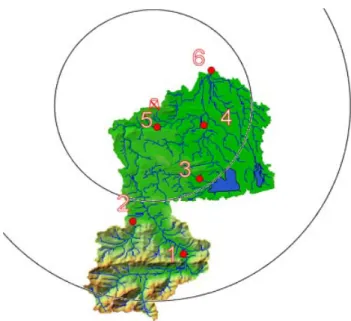
Fig. 2. Location of the six river gauges (red circles) and radar site at
Hohenpeissenberg with range rings at 15 and 30 km; Numbers refer to gauges in Table 1.
rainfall intensities. The parameter estimation was applied on five subcatchments. It was repeated using different starting values for two times and resulted finally in:
Z =104R1.43 <36.5 dBZ
Z =146R1.57 36.5 · · · 45 dBZ
Z =93R1.63 >45 dBZ (4)
A comparison of the hydrological simulation results is given in Table 2. The use of Z=256 R1.42caused an under-estimation of areal rainfall and therefore an underunder-estimation of the simulated discharges. It must be noted that the re-sults of the subcatchment Oberammergau in the Ammergau Alps improved in comparison to simulations using raingauge data. This may be explained due to the fact that no rain-gauge data has been available for that mountainous region, and that raingauges located north and south of the Ammer-gau Alps have been used for the statistical interpolation. A comparison of simulated river discharges using rainfall data estimated by the simplified version of the method proposed by RADOLAN (2004) to observed river discharges shows good accordance. Even if this method is only an intermediate step in the computation of areal precipitation at the German Weather Service, the results of this study show that the esti-mation of areal radar precipitation outperforms interpolated raingauge data. Runoff simulations with the new found split three-part Z/R-relationship show overall the best results.
28 A. Marx et al.: Radar rainfall estimates using inverse hydrological modelling
Table 2. Performance of river runoff simulations using different areal rainfall estimates for summer 2001.
River gauge IDW Radar rainfall, Radar rainfall, Radar rainfall, from Z=256R1.42 Eq. (2), Eq. (4),
raingauge data (simplified RADOLAN) calibrated using river discharge Oberammergau 0.1628 0.3884 0.7869 0.7689
Halbammer 0.5431 0.2920 0.5468 0.5729 Obernach 0.6365 0.4055 0.5797 0.6283 Peissenberg 0.9554 0.9114 0.9650 0.9662 Weilheim 0.9481 0.8742 0.9764 0.9767
Figure 3.
WaSiM-Parameter Calibration results at gauge Weilheim (left) and gauge Obernach
(right side) using interpolated raingauge measurements from 15 sites.
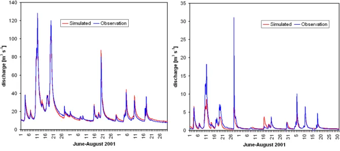
Figure 4. Hydrological simulation results using the calibrated divided Z/R-relationship
compared to Observations at gauge Weilheim (left) and gauge Obernach (right side).
11
Fig. 3. WaSiM-Parameter Calibration results at gauge Weilheim (left) and gauge Obernach (right side) using interpolated raingaugemea-surements from 15 sites.
6 Summary and conclusions
For this study, hourly areal precipitation was estimated using 1. statistically interpolated raingauge data,
2. estimated radar rainfall from a standard Z/R-relationship 3. radar rainfall from improved Z/R-relationships which
are divided into three parts, and
4. a calibrated version of (3) using measured river dis-charges and a calibrated hydrological model.
The distributed hydrological model WaSiM was adapted to the alpine Ammer catchment and calibrated using statisti-cally interpolated raingauge data from 15 stations. The study has shown that radar data can be used to improve river dis-charge simulations over a continuous period of three months in comparison to raingauge data. On the other hand side, measured river discharges are used to estimate areal precipi-tation using a calibrated hydrological model. Rainfall runoff
modelling for a three month period in summer 2001 using radar data estimated with Z=256 R1.42showed an underes-timation of areal precipitation and therefore an underestima-tion of simulated runoff. The results using a simplified ver-sion of the relationship given in RADOLAN (2004) showed a slight underestimation of total areal rainfall sum in summer 2001 in comparison to interpolated raingauge data, but out-performed results of the hydrological simulations. The best results have been obtained with the new found three-part Z/R-relationship.
Acknowledgements. This work was partially performed under the
framework of the Centre of Numerical Environmental Simulation at the University of Augsburg and funded by the Bavarian High Tech Initiative.
Edited by: R. Barthel, J. G¨otzinger, G. Hartmann, J. Jagelke, V. Rojanschi, and J. Wolf
Reviewed by: anonymous referees
A. Marx et al.: Radar rainfall estimates using inverse hydrological modelling 29
Figure 3.
WaSiM-Parameter Calibration results at gauge Weilheim (left) and gauge Obernach
(right side) using interpolated raingauge measurements from 15 sites.
Figure 4. Hydrological simulation results using the calibrated divided Z/R-relationship
compared to Observations at gauge Weilheim (left) and gauge Obernach (right side).
11
Fig. 4. Hydrological simulation results using the calibrated divided Z/R-relationship compared to Observations at gauge Weilheim ( left) andgauge Obernach (right side).
References
Chumchean, S., Seed, A., Shara, A.: Correcting of real-time radar rainfall bias using a Kalman filtering approach, J. Hydrol., 317, 123–137, 2006.
Collier, C. G., Larke, P., and May, B.: A weather radar correction procedure for real-time estimation of surface rainfall, Quat. J. Roy. Meteorol. Soc., 109, 589–608, 1983.
Doelling, I. G., Joss, J., and Riedl, J..: Systematic Variations of Z-R relationships from drop size distributions measured in northern Germany during 7 years, Atmos. Res., 47–48, 635–649, 1998. Fulton, R. A., Breidenbach, J. P., Seo, D.-J., Miller, D. A., and
O’Bannon, T.: The WSR-88D rainfall algorithm, Wea. Forecast., 13, 388–395, 1998.
Gabella, M. and Amitai, E.: Radar rainfall estimates in an alpine environment using different gage-adjustment techniques, Phys. Chem. Earth (B), 25(10–12), 927–931, 2000.
Green, W. H. and Ampt, GA.: Studies on Soil Physics: I. The flow of air and water through soils, J. Agric. Sci., 4, 1–24, 1911. Joss, J. and German, U.: Solutions and problems when
apply-ing qualitative and quantitative information from weather radar, Phys. Chem. Earth (B), 25(10–12), 837–841, 2000.
Krause, J.: Inverse hydrologische Modellierung fr das Einzugsge-biet der Ammer mittels WaSiM-ETH und PEST, University of Trier, master thesis (in german), 135 p., 2003.
Marshall, J. S. and Palmer, W. McK: The distribution of raindrops with size, J. Meteorol., 5, 165–166, 1948.
Mayr, S.: Inverse flchendifferenzierte hydrologische Modellierung des Ammer-Einzugsgebietes mittels Kombination von Grund-und Oberflchenwasserdaten, University of Augsburg, master the-sis (in german), 132 p., 2004.
Monteith, J. L.: Vegetation and the atmosphere, Vol. 1, Principles, Academic Press, London, 1975.
Nash, J. E and Sutcliffe, I. V.: River flow forecasting through con-ceptual models, J. Hydrol., 273, 282–290, 1970.
Peschke, G.: Soil Moisture and Runoff Components from a Physi-cally Founded Approach, Acta hydrophysica, 31(3/4), 191–205, 1987.
RADOLAN (Radar Online Adjustment), German Weather Service, Department for Hydrometeorology, http: //www.dwd.de/de/wir/Geschaeftsfelder/Hydrometeorologie/ a href pages/RADOLAN/radolan-online.htm (in german), 2004.
RAPHAEL: Runoff and Atmospheric Processes for Flood Hazard Forecasting and Control, EU project ENV4-CT97-0552, 2000. Rosenfeld, D., Wolff, D. B., and Amitai, E.: The Window
Proba-bility Matching Method for rainfall measurements with radar, J. Appl. Meteor., 34, 212–223, 1994.
Schulla, J. and Jasper, K.: Model description WaSiM-ETH, Institute for Geography, ETH, Z¨urich, 167 pp., 2000.
Van Genuchten, M. T.: A Closed-Form Equation for Predicting the Hydraulic Conductivity of Unsaturated Soils, Soil Sciences So-ciety of American Journal, 44(5), 892–898, 1976.
Wu, Z. J. and Tokay, A.: Spurious power-law relations among rain-fall and radar parameters, Quat. J. Roy. Meteorol. Soc., 128, 2045–2058, 2003.