HAL Id: hal-00301685
https://hal.archives-ouvertes.fr/hal-00301685
Submitted on 13 Jul 2007
HAL is a multi-disciplinary open access
archive for the deposit and dissemination of
sci-entific research documents, whether they are
pub-lished or not. The documents may come from
teaching and research institutions in France or
abroad, or from public or private research centers.
L’archive ouverte pluridisciplinaire HAL, est
destinée au dépôt et à la diffusion de documents
scientifiques de niveau recherche, publiés ou non,
émanant des établissements d’enseignement et de
recherche français ou étrangers, des laboratoires
publics ou privés.
Mediterranean high impact weather: a contribution
based on intense cyclones
V. Homar, A. Jansà, J. Campins, A. Genovés, C. Ramis
To cite this version:
V. Homar, A. Jansà, J. Campins, A. Genovés, C. Ramis. Towards a systematic climatology of
sen-sitivities of Mediterranean high impact weather: a contribution based on intense cyclones. Natural
Hazards and Earth System Science, Copernicus Publications on behalf of the European Geosciences
Union, 2007, 7 (4), pp.445-454. �hal-00301685�
Nat. Hazards Earth Syst. Sci., 7, 445–454, 2007 www.nat-hazards-earth-syst-sci.net/7/445/2007/ © Author(s) 2007. This work is licensed under a Creative Commons License.
Natural Hazards
and Earth
System Sciences
Towards a systematic climatology of sensitivities of Mediterranean
high impact weather: a contribution based on intense cyclones
V. Homar1, A. Jans`a2, J. Campins2, A. Genov´es2, and C. Ramis11Meteorology Group, Departament de F´ısica, Universitat de les Illes Balears, Spain 2Centro Meteorol´ogico en Illes Balears, Instituto Nacional de Meteorolog´ıa, Spain
Received: 26 March 2007 – Revised: 18 June 2007 – Accepted: 27 June 2007 – Published: 13 July 2007
Abstract. One of the multiple approaches currently explored
to mitigate the effects of hydro-meteorological hazardous events aims at improving the numerical weather forecasts. Under an ever increasing societal demand for cost cuts and more precise forecasts, targeted observations are currently receiving great attention within the operational weather com-munity. The MEDEX project (http://medex.inm.uib.es) is aimed at improving the forecasts of high impact weather (HIW) in the Mediterranean and, in particular, proposes the creation of a climatology of sensitivities of such episodes. The construction of a comprehensive climatology of sensi-tivities is hampered by the lack of an exhaustive collection of Mediterranean HIW events.
In this study we contribute with a systematic climatology of Mediterranean intense cyclones. We perform an objec-tive cluster analysis of intense cyclones detected from the ECMWF ERA40 reanalysis using a k-means algorithm and compute the sensitivities for each of the resulting classes. For each cluster, a representative sensitivity field is com-puted using the MM5 Adjoint Modeling system. The results show that although the sensitive areas for intense Mediter-ranean cyclones are not particularly confined, it is remark-able how areas poorly sampled by the regular observing net-works, such as North Africa, the Mediterranean Sea and the eastern North-Atlantic, are highlighted in the prototype sen-sitivity maps.
1 Introduction
Operational weather prediction centers are receiving increas-ing pressure from the public and the authorities to extend and improve the forecasts while reducing costs and increas-ing efficiency. The European community is strongly
com-Correspondence to: V. Homar
(victor.homar@uib.es)
mitted to accomplish this increased efficiency on the ob-servational component of the weather forecasting process. The Network of European Meteorological Services Compos-ite Observing System project (EUMETNET-EUCOS, http: //www.eumetnet.eu.org/conteucos.html) is appointed to opti-mize the composite observing system at European scale with a view to improve short range forecasts over Europe with-out increasing significantly the overall cost. The “EUCOS Plan” recognized the necessity to identify data sparse areas around Europe, and more specifically, the first objective of the “EUCOS High Level Design” is to clearly identify the ar-eas where an incrar-eased observation effort needs to be imple-mented in order to improve numerical weather predictions. To this end, the EUCOS programme established as a prior-ity the generation of a climatology of forecast sensitivities. At european scale and in average for all weather regimes, sensitivities of forecast errors are located roughly over the Northeastern Atlantic, in good agreement with the intuitive idea regarding the importance of structures located upstream of the Mediterranean along the climatological mid-latitude westerlies (Marseille and Bouttier, 2000). For the sake of efficiency, decisions regarding the location and deployment time for new observations or regarding the optimization of the permanent component of observational networks should take into special consideration the weather that entails high social impact. There is a special interest in analyzing the sen-sitivities of high impact weather (HIW) due to the larger as-sociated benefits from better warnings of hazardous weather, supported by the expected forecast improvements.
The “Mediterranean experiment on cyclones that pro-duce high impact weather in the Mediterranean” (MEDEX, http://medex.inm.uib.es) is a subproject of THORPEX en-dorsed by the “World Weather Research Program” of the “World Meteorological Organization”. MEDEX coordinates weather services and research institutions from most coun-tries of the Mediterranean basin. The “MEDEX Scientific Plan” is designed to contribute to the basic understanding and
short-range forecasting of HIW events in the Mediterranean, mainly heavy rain and strong winds. Being the Mediter-ranean a region affected regularly by cyclones that produce hazardous weather such as strong windstorms or heavy rains that may produce extreme floods, one milestone within the project is the calculation of sensitive areas where an increase in the number, quality or type of observations would improve the numerical prediction of these episodes.
Provided the common interest between EUCOS and MEDEX, collaboration and support between the two projects were established, and an agreement was formalized that pro-moted the production of a climatology of short-range sensi-tive areas for Mediterranean intense cyclone events.
The lack of good databases of Mediterranean HIW events has made the design of a strategy to generate the full clima-tology of sensitivities of HIW events more difficult. Homar et al. (2006) reported on a first approach that focused on Mediterranean intense cyclones. The cyclones were classi-fied subjectively according to the trajectory of their center and the representative sensitivity of each of the 19 cyclone classes were derived using an adjoint model on a single case belonging to the class. The conclusions presented in Homar et al. (2006) regarding the sensitivity of each cyclone type had limited representativity due to the lack of a constrain that forced the homogeneity of preceding conditions within each cyclone class. In this paper, a second step towards the com-position of the climatology of intense cyclones sensitivities is presented. We make use of an objective cyclone classifica-tion method that promotes homogeneity of preceding condi-tions within the classes and therefore it improves how repre-sentative the derived sensitivity fields for each cluster are.
The following section discusses the methodological details of this study and some caveats in the databases that need special treatment in the classification and sensitivity com-putations. Sections 3 and 4 present the results of the clus-tering method and the sensitivity fields of each cyclone type. The conclusions and a discussion of their implications is pre-sented in Sect. 5.
2 Methodology
In order to build the climatology of short-range sensitivi-ties of high impact weather in the Mediterranean, a well-defined climatology of such events, consistent across the re-gion, should be used as a starting point. As far as we know, the most recent effort to build such a climatology is being carried out within the MEDEX community. However, many difficulties have arisen during the data collection process. The climatology of Mediterranean HIW is currently a list of cases selected by the project members as important and representative of HIW in their region (http://medex.inm.uib. es/data/Selection cases.htm). This list is not exhaustive and does not include systematic information, neither meteorolog-ical nor about the societal impacts, for all events. Thus, since
a useful HIW database for our purposes is not currently read-ily available, alternatives to systematize the identification of HIW are explored.
A natural approach is to use the strong link between HIW and intense cyclones. Although most of Mediterranean HIW events are linked to cyclones (Jans`a et al., 2001), not all of these cyclones are intense. However, intense cyclones are naturally associated with HIW. In an attempt to identify events that produce high impact in the Mediterranean, while admitting the inadequacy of the available HIW databases, we use the intense cyclones as a first contribution towards a more exhaustive climatology including all types of HIW events. Indeed, a cyclones database has been constructed under the MEDEX framework (publicly available at http: //medex.inm.uib.es) and it is used here to identify types of intense cyclones. The cyclones catalogue is based on the Re-analysis fields from the European Center for Medium-Range Weather Forecast (ERA-40, Uppala et al., 2005) and char-acterizes the size, position, intensity, depth and path of all sea-level pressure cyclones within a domain that covers the Mediterranean region (see Fig. 1). The detection and track-ing algorithms, as well as the characterization methods used to build the database, are thoroughly described in Picornell et al. (2001) and Campins et al. (2006).
Intense cyclones in this study are selected as those cyclonic systems with maximum circulation exceeding 7×10⁷m2s−1and a lifetime of at least 24 h. The intensity measure is computed as an area integral of the geostrophic vorticity at 1000 hPa over the area around the cyclone’s cen-ter with positive geostrophic vorticity. Using this definition and threshold for the intensity values, 1359 intense cyclones in 1349 days were detected by the automatic algorithm in the study domain over the 45 years period covered by the ERA-40 data (September 1957 to August 2002). This im-plies a mean frequency exceeding 30 intense cyclones per year, which agrees well with the order of magnitude of the average number of significant cyclones per year that one might allegedly assume to occur over the entire Mediter-ranean. The upper panel in Fig. 1 depicts the number of cyclones that achieve maximum intensity within an area of 2.25◦×2.25◦. The highest frequency of intense cyclones is located south of the Alps, which is consistent with the re-sults of Petterssen (1956) that highligted the southern alpine flank (i.e. Gulf of Genoa and Northern Adriatic Sea) as the most cyclogenetic area in the Mediterranean. The areas with persistent occurrence of mature intense cyclones arise to the south and southeast of the most cyclogenetic areas. Indeed, most of the cyclones that achieve maximum intensity over the Adriatic and Thyrrenian are likely of alpine origin. Cyprus, Turkey and the Black Sea are also well known cyclogenetic areas, unlike the Ionian Sea which is also highligted in Fig. 1 as a region with a high occurrence of mature intense cy-clones. As opposed to all other zones prone to the occurrence of intense cyclones, the maxima obtained over north Africa
V. Homar et al.: Climatology of intense Mediterranean cyclones 447 0% 5% 10% 15% 20%
January February March A pril May June July A ugust SeptemberOctober November December
Fig. 1. Upper panel) Number of intense cyclones over the 45 years
ERA-40 period at mature stage per squares of 2.25◦×2.25◦. Lower panel) Monthly frequency of intense cyclones in the ERA-40 anal-ysis 1957–2002 (white) and monthly distribution of episodes in the MEDEX “list of selected cases” (grey).
mostly represent large thermal lows that fit the criteria of cir-culation but do not have high vorticity or strong winds asso-ciated with them. Indeed, most of the north African intense cyclones develop during summer while the average monthly distribution of Mediterranean intense cyclones show maxi-mum frequencies during the winter months (lower panel in Fig. 1). In this regard, most of the actual dynamical cyclo-genesis occurring over North Africa that lead to an intense cyclone, produces eventually a mature intense cyclone over the Mediterranean Sea, being accounted for over that area, and not so over the North African plateau. These popula-tion of intense cyclones that are not linked to high impact weather will require a special treatment at the later classifi-cation stage.
In order to classify the 1349 days into homogeneous classes we use the non-hierarchical k-means classification algorithm (Anderberg, 1973), as implemented in the R pack-age (R Development Core Team, 2006). The set of prototype intense cyclones is derived by subjecting the T-mode (day-by-day) correlation matrix to principal components analysis (PCA), reducing the problem size while keeping significant variance (above 97%), and then carrying out cluster
analy-Table 1. Fields, number of principal components (PCs) and
num-ber of clusters. First round used Sea Level Pressure (SLP) over the Mediterranean at the time of maximum intensity of the cyclone (tmax)whereas the second round also used geopotential height at
500 hPa (H) and temperature at 850 hPa over the whole domain, 24 h prior to tmax. The number of clusters in which each of the 16
classes obtained from round 1 were divided was subjectively de-cided between 1 and 5 subclasses by visual inspection of the results for each test (see text for details).
Round Fields # PCs # Clusters 1 SLP tmaxMED 25 16 2 SLP tmaxMED 15 1–5 each from round 1 H 500 hPa tmax-24h 10 T 850 hPa tmax-24h 10
sis (CA) on the most important extracted components. That is, days participating with similar loadings on the extracted components are clustered together. This approach is aimed at joining days with similar distribution of the classifying fields rather than similar actual values, ensuring a classifi-cation independent of the seasonal variation of the absolute values of the fields. The aim of the clustering process is to obtain classes of intense Mediterranean cyclones with simi-lar 48 h lead-time sensitivity fields. The sensitivity fields de-pend greatly on the preceding synoptic situation, as well as the location of the mature cyclone. Consequently, the clas-sification will be based on fields characterizing the location of the cyclone at the time of maximum intensity as well as the fields that characterize the situation preceding that time. Here, two rounds of classification were used (Table 1).
The first round is intended to regionalize the database so that cyclones that achieved maximum intensity on the same area, get clustered together. Sea-level pressure at the time of maximum cyclone intensity over an area that covers the entire Mediterranean is used as classifying field for this first round. The decision about the adequate number of clusters was made subjectively based on visual inspection of various tests. None of the objective indexes that were tested was use-ful in guiding this process, so the final decision of defining 16 clusters was made based on human judgement. The resulting clusters included a representation of all the classical types of Mediterranean intense cyclones. Thus, after the first round, cyclones belonging to one cluster happen to achieve matu-rity over the same region in the Mediterranean. This does not ensure homogeneity of preceding conditions, and so the existence of a unique representative field of sensitivities for each of these classes is highly unlikely. As mentioned before, the large thermal north African cyclones typical of summer months are included in the database due to the size of the cyclone rather than its intensity. Fortunately, these cyclones get clustered together at this first round, and their character-istics can be assessed specifically. Most of these cyclones
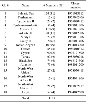
Table 2. Intense cyclone clusters as derived from the two rounds
of k-means clustering. Dates of the closest members to the centroid are formatted as YYYYMMDDHH.
CL # Name # Members (%) Closest member 1 Balearic Sea 124 (11) 1971013112 2 Tyrrhenian I 12 (1) 1979092406 3 Tyrrhenian II 24 (2) 1969020412 4 Tyrrhenian-Adriatic 51 (4) 1987011206 5 Adriatic I 110 (9) 1971021706 6 Adriatic II 128 (11) 1999012906 7 Sicily I 77 (7) 1959031306 8 Sicily II 70 (6) 2001011406 9 Ionian-Aegean 109 (9) 1994013000 10 Greece 55 (5) 1980010312 11 Cyprus 90 (8) 1992121500 12 Turkey 67 (6) 1988030918 13 Black Sea 74 (6) 1966121506 14 Atlantic 73 (6) 1982011200 15 North-West 27 (2) 1978050418 Africa I 16 North-West 15 (1) 1974041906 Africa II 17 North-West 21 (2) 1973032212 Africa III 18 Libya 52 (4) 1974042500 Total 1179
are shallow, being detectable only up to 700 hPa while most of the 1359 intense Mediterranean cyclones of the database are deep, achieving the 300 hPa level. In addition, the aver-age maximum winds associated with these 96 north African cyclones is 11.7 ms−1, much lower than the average maxi-mum winds for the complete dataset, 17.2 ms−1. Owing to these differences, this whole class is discarded from the later analysis.
For the sake of more homogeneous groups in terms of pre-ceding atmospheric conditions, the second round of classifi-cation also takes into account the fields of geopotential height at 500 hPa and temperature at 850 hPa over the entire domain valid 24 h prior to the time of cyclone maturity. Each first-round cluster were divided from 1 (no division) to 5 sub-groups. All results from the second round of classification were analyzed subjectively and the most appropriate number of subgroups for each first-round cluster were subjectively decided using the criteria of minimizing the final number of classes and maximizing the homogeneity of the fields within each cluster. For most of the first-round clusters, the sec-ond step was very useful to refine the cluster by eliminating outliers that were very easy to identify in the high order divi-sion tests. As an example, the centroid of first-round cluster number 4 shows a cyclone over Sicily and contains 72 mem-bers. The second round test that divides this in 2, shows one
subgroup with 70 members and the other with 2 members with intense cyclones shifted to the west and very different 24 h preceding fields than those of the 70 members subgroup. Thus, the final cluster of Sicily cyclones was chosen to be the first subgroup, discarding the 2 outliers from the latter sensi-tivity analysis.
A total of 18 types of episodes that produce intense cy-clones in the Mediterranean on 1179 different days were fi-nally derived (Table 2). A description of the results of the classification is presented in Sect. 3. In order to obtain a rep-resentative sensitivity field for each of the 18 clusters, we select the most similar member to the cluster centroid, that is, the closest member of the cluster to the centroid in the space of PC loadings. Then, the sensitivity fields for this closest member are calculated using the MM5 Adjoint mod-eling system (Zou et al., 1997, 1998).
The adjoint model (L∗) is a tangent linear operator that traces back in time the gradients vector of a response func-tion (∇xJ) with respect to the forward (standard nonlinear) model fields (x), along forward model trajectories in phase space (see Errico, 1997, for an introduction to adjoint tech-niques in numerical weather prediction). As a result, the gra-dients of the response function, defined at a forecast time, with respect to the model fields at an earlier time (usually the initial conditions time) are obtained:
∇xJ |t =t0 = L∗∇xJ |t =tf
where t0 is the initial conditions time, tf the forecast time when the response function (J) is defined. These fields ( ∇xJ |t =t
0) inform about the changes in the forecast that will be obtained for a certain perturbation to the model fields, which is commonly referred to as the sensitivity of the fore-cast to the model fields:
1J |t =tf = ∇xJ · 1x|t =t0
where 1x is a perturbation to the initial conditions and
1J |t =tf is the linear estimate of change in the response func-tion J derived from the sensitivity field ∇xJ |t =t0.
The selection of J is a key point in the construction of the climatology of sensitivities. Any sensible comparison between different sensitivity fields must be done using the same response function. Otherwise, we would need to make use of balance relationships which would allow for quantita-tive comparison among them. Since all episodes considered in this study are connected to an intense cyclone, we define as response function the 48 h forecast of the pressure perturba-tion field at the 3 lowest σ model levels over an area centered on the predicted cyclone minimum pressure. Note that the lo-cation of the predicted cyclone may differ from the lolo-cation in the cluster centroid. In consequence, the response func-tion will be defined based on the posifunc-tion of the predicted cyclone of the closest member to the centroid, as opposed to the cyclone center on the centroid fields. This allows to better capture in the sensitivities of the physical processes
V. Homar et al.: Climatology of intense Mediterranean cyclones 449 leading to the predicted cyclone. Besides, although humidity
involves highly nonlinear processes that hamper the applica-bility of the adjoint model (Vuki´cevi´c and Errico, 1993), we turn on the adjoint of the explicit moisture parameterization (Dudhia, 1989) in the adjoint model run because it is an influ-ential factor in many Mediterranean intense cyclonic events that must be considered in the sensitivity calculations. For a more detailed description of the adjoint model and its appli-cation to a Mediterranean cyclone, see Homar and Stensrud (2004). The adjoint model computes the gradients of the re-sponse function with respect to each model field on the initial conditions.
A way of summarizing the results is to compute the av-erage over all fields and vertical levels, which provides a good perception of the most sensitive regions, hiding in all information about the sensitivity of the response function to different levels or fields and resulting in a quantity with non-physical units ([Pressure units]/[“IC units”], Homar and Stensrud, 2004). This simple averaging over vertical levels and over wind components, temperature, pressure perturba-tion and specific humidity is the standard product, hereafter referred to as “sensitivity”. This product is used to summa-rize the complete set of gradients for each case and to fa-cilitate the comparison among different regions and classes. The interpretation of such an index is analogous to a sensi-tivity field but extrapolable to the vertical levels: high values of “sensitivity” highlight areas where changes to the fields of U,V,T,PP or q at some (undetermined with this field) level in the vertical will produce significant changes to the response function (i.e. central sea level pressure in the predicted in-tense cyclone).
Since the response function for each case is defined fol-lowing a common criteria, the comparison of results among classes is possible. In addition, further calculations are at-tempted in order to obtain a single summarizing map that sketches the most important areas of sensitivity for the in-tense Mediterranean cyclones. The sensitivity fields and the results derived from them are presented in Sect. 4.
3 Clustering results
The results obtained from the double round of k-means clus-tering algorithm show a diverse typology of cases that cover very well the entire Mediterranean region (Fig. 2). On the western basin, the Adriatic (I and II) is the most frequent type of intense cyclone in the Mediterranean with more than 200 events in the database (∼20%). This is consistent with the climatological fact that the Genoa Gulf is the most cy-clogenetic area in the Mediterranean (Petterssen, 1956) and most of the cyclones that achieve maximum intensity over the Adriatic, are likely to originate in that area. Classes
Adri-atic I and II differ in the location of the sea level pressure
cyclone center but also on the 24 h preceding conditions. Both types of intense cyclone develop under the presence of a
deep trough at 500 hPa that extends from north Europe down to North Africa and a ridge over the eastern north Atlantic. However the mean trough is deeper and shifted to the east for the Adriatic II cases than those grouped in class
Adri-atic I. Therefore, the classes are not merged into a single one
to prevent the two different sensitivity fields to be smoothed out. The other type of cyclones that lay from the Balearic Sea to the Adriatic are represented by classes 1 to 4, under very different configurations of sea-level pressure highs over the Atlantic (upper row and left panel of second row in Fig. 2).
Cyclones that achieve maximum intensity over Sicily rep-resent also a large portion of the population (13%), develop-ing under two different synoptic SLP patterns (left and mid-dle panels of third row in Fig. 2). Sicily II cyclones form un-der the influence of a high pressure system over Europe that produces strong south and south-easterly winds over Greece and the Adriatic basin. Class Sicily I differs from Sicily II in the presence of a weak pressure high between Azores and Canary Islands as oposed to the general cyclonic flow over the Atlantic part of the domain for class Sicily II.
Regarding the cyclones of the central basin, the
Ionian-Aegean class is the most frequent type (9%) and together with
the Greece cyclones produce strong winds (e.g. Bora) over the Adriatic basin. Further to the east, the Cyprus, Turkey and Black Sea clusters represent a 20% of the total population and typically form under a synoptic trough aloft over eastern Europe that extends south towards the Ionian Sea.
As shown in Fig. 1, the area over which the intense cy-clones were detected from the ERA-40 database included a narrow strip of the Atlantic Ocean. Consequently, a number of Atlantic cyclones slipped in the climatology. As expected, these cases were clustered together by the k-means algorithm and could have been easily removed from the study. How-ever, many of these situations produce strong winds and pre-cipitation over Mediterranean Spain (Romero et al., 1999) and so even though the cyclones are not Mediterranean, the entailed impacts affect the Mediterranean and so they are eventually considered in this study. The preceding condi-tions for these cyclones are characterized by deep Atlantic troughs aloft progressing eastwards towards western Europe. The last four classes resulting from the two rounds of clas-sification are North-African systems that are associated with high impact weather, either by being associated with strong winds (Libyan depressions) or by being responsible for east-erly moist flows that impinge the Tunisian, Algerian and Spanish coasts, producing deep moist convection and heavy precipitation. The preceding conditions for these events usu-ally show a deep cold trough at mid levels extending down to North Africa which generates a large baroclinic region where the intense cyclone rapidly develops.
Balearic Sea Tyrrhenian Sea I Tyrrhenian Sea II
Tyrrhenian-Adriatic Adriatic Sea I Adriatic Sea II
Sicily I Sicily II Ionian-Aegean Seas
Greece Cyprus Turkey
Black Sea East Atlantic North-West African I
North-West African II North-West African III Libya
V. Homar et al.: Climatology of intense Mediterranean cyclones 451
Balearic Sea Tyrrhenian Sea I Tyrrhenian Sea II
Tyrrhenian-Adriatic Adriatic Sea I Adriatic Sea II
Sicily I Sicily II Ionian-Aegean Seas
Greece Cyprus Turkey
Black Sea East Atlantic North-West African I
North-West African II North-West African III Libya
Fig. 3. Representative normalized sensitivity to initial conditions for each of the 18 intense cyclones shown in Fig. 2. Normalization refers to
the area over which the response function is defined. Actual values for this field are unphysical (see text for details). Darker areas show higher sensitivities. Geopotential height (m) at 500 hPa and Temperature (◦C) at 850 hPa valid at the same time are also depicted for reference.
Fig. 4. Average of 48-h sensitivities to central cyclone pressure weighted by the intense cyclone frequency within the database. Darker colors indicate higher sensitivities.
4 Sensitivity fields
For each of the classes listed in last section, the sensitivi-ties of the prototype cyclogenetic development are computed using the adjoint model on the closest member to the clus-ter centroid (see Table 2 for the dates). As one could ex-pect, there is a wide range of areas that are influential on the 48 h development of intense Mediterranean cyclones. Fig-ure 3 show the normalized sensitivity (i.e. the averaged sen-sitivity per area unit of the response function) for the 18 cy-clone types. Sensitivity patterns tend to focus on strong gra-dients on the temperature and height fields, confirming its relevance on the future evolution of the situations and even-tual cyclone development. Although this link between mid-levels mass fields gradients and subsequent low-level cyclo-genesis can be directly inferred from the quasi-geostrophic tendency equation, without the need for running an adjoint model, the adjoint fields provide a more detailed sensitiv-ity field. The adjoint sensitivities not only provide valuable information pointing to specific zones of the dynamic struc-ture that one might infer from dynamical conceptual models, but also highlight other areas of the domain, sometimes even downstream of the cyclone, that pose challenging questions regarding the dynamical factors involved in the intense cy-clone development.
The cases affecting the Western Mediterranean (three top rows in Fig. 3) show most of the sensitivity over the Atlantic but also unveiling lower, but significant, values extending eastward along the westerlies belt up to the eastern bound-ary of the model domain. It is noteworthy how in cases were the westerlies are split, the adjoint model emphasizes both branches of the flow, as in the Tyrrhenian Sea II or Sicily II cases. The cases of Tyrrhenian-Adriatic and Adriatic II are particularly interesting due to the important sensitivity ob-tained downstream, over the Eastern Mediterranean. This
might be interpreted as a reflection of the crucial role played in this particular cases by downstream structures that remain quasi-stationary during the cyclogenetic and maturing stages of the intense cyclone, thus interacting with the main trough. Cyclones developed over central and eastern Mediter-ranean are mostly sensitive to the North-African regions and the Mediterranean Sea. A particular picture is produced by the Cyprus cyclones, that are sensitive both to the mid-level advection of northwestern cold air and its interaction with the subtropical jet detected over north-Africa. This is indicated by the adjoint highlighting sensitive areas over northern Eu-rope and the Atlantic, together with north-African regions. Regarding the north African cyclones (North-West Africans
and Libya), sensitive areas are also obtained over the
west-erlies, with special attention on downstream areas, with the Eastern Mediterranean being specially influential, arguably due to the aforementioned blocking effect.
The mosaic of results shown in Fig. 3 is summarized by computing a mean over all 18 cyclone types, weighted by the relative frequency of each type within the database, shown in Table 2. This provides a single figure intended to inform about the climatological areas where the prediction of intense Mediterranean cyclones is most sensitive (Fig. 4). This plot highlights the areas over the eastern North Atlantic and the Eastern Mediterranean as important for the 48-h prediction of intense Mediterranean Cyclones. The Atlantic signal agrees with the sensitive area obtained by Marseille and Bouttier (2000), that used a target area centered over the Mediter-ranean and considered all types of weather situations. How-ever, the persistently high sensitivity areas found over the eastern Mediterranean, mostly downstream of the area of in-terest, must be interpreted as a result of two different effects: the aforementioned influence of downstream structures on the evolution of the trough that is dynamically linked to the cyclogenesis (as in classes Adriatic Sea II or Libya), and also the direct dynamical effect of upstream structures on the cy-clone formation (as in classes Cyprus and Turkey). These effects are highlighted in the climatological picture because the four classes mentioned represent almost a third of the to-tal population, thus having an important weight in the mean sensitivity field. Beside the two main regions, also continen-tal Europe, the Mediterranean Sea and North Africa emerge as climatologically sensitive areas for the 48-h forecast of in-tense Mediterranean cyclones. Remarkably, the southwest-ern part of the domain is not emphasized as sensitive al-though the Tyrrhenian Sea II, Ionian-Aegean Seas and
North-West African classes show some sensitivity to that region.
This is a benefit of the weighted mean, that highlights the areas where the most frequent cyclone classes show sensi-tivity and so provides a better guidance to support decisions regarding the efficiency of new observational strategies.
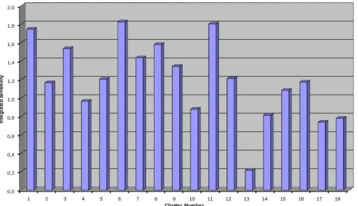
The use of a common framework to compute the sensi-tivities of all intense cyclone classes allows to perform ad-ditional comparison among them. The root mean squared (RMS) of the “artificial” sensitivity fields shown in Fig. 3
V. Homar et al.: Climatology of intense Mediterranean cyclones 453 0,0 0,2 0,4 0,6 0,8 1,0 1,2 1,4 1,6 1,8 2,0 1 2 3 4 5 6 7 8 9 10 11 12 13 14 15 16 17 18 In te g ra te d s e n si ti v it y Cluster Number
Fig. 5. Root mean squared of the sensitivity field for each intense cyclone cluster. This is a vague estimate of cyclone’s central sea-level
pressure predictability that allow for sensible comparison among the clusters (see text for details).
gives an integral estimate of the predictability of each class. Provided that the sensitivity field is artificial, the RMS has not physical meaning, but the comparison among them pro-vides a good measure of the relative predictability of each cyclone class compared to the others. Everything else being equal (e.g. the analysis error), a cyclone class showing larger RMS sensitivity means that, in average, the 48-h forecast of those cyclones will change more than another class showing less sensitivity under similar perturbations (or initial condi-tions errors). Therefore, the larger the integrated sensitivity (i.e. the RMS sensitivity), the lower the predictability. Fig-ure 5 shows how the 48-h central pressFig-ure forecast for some classes are more than twice as sensitive to initial conditions as others. Adriatic Sea II, Cyprus and Balearic Sea cyclones show the largest sensitivities, whereas the Black Sea, East
Atlantic, North-West African III and Libya arise as the most
48-h predictable intense cyclones in the dataset.
5 Conclusions
This paper reports on the first step towards building a sys-tematic climatology of sensitivities for Mediterranean high impact weather. Provided the lack of complete and consis-tent databases of damaging weather events in the region, we perform a first contribution by focusing on intense Mediter-ranean cyclones.
We classify intense cyclones accounting for not only the location of the cyclone center at the time of maximum in-tensity but also for the tropospheric situation preceding the events. The use of atmospheric fields 24 h before the cy-clones achieve mature stage in the classification process is intended to cluster together those cyclones that not only be-come mature over the same location in the Mediterranean but
also originate from a similar precursor atmospheric pattern. Then for each of the 18 intense cyclone classes, the sensi-tivity of the pressure field around the center of the cyclone is computed using an adjoint model. The closest member to each cluster centroid is used as the representative member of each class. The adjoint sensitivity calculations are set up using a common framework for all classes that allows later comparison and averaging among the individual sensitivity fields.
Given the climatological sensitivity results, summarized in Fig. 4, future decisions regarding the optimization of the ob-servational strategies with regard to Mediterranean weather should put special attention to the North Atlantic, the north African countries (particularly the easternmost regions) and the Mediterranean Sea. These areas emerge as determinant for the 48 h forecast of intense Mediterranean cyclones and are systematically not well sampled by the operational ob-servation networks. Continental Europe and the British Isles are also emphasized by the results but these regions are rou-tinely well sampled by operational networks. Increasing the number and quality of routine observations over north Africa and the Mediterranean Sea will likely be also beneficial for forecast times shorter than the 48 h analyzed in this study.
Future work along this research line will focus on the use of the cluster centroid to produce the sensitivity fields, in-stead of a particular member of the cluster. Furthermore, the robustness of the sensitivity fields should be tested by using other response functions that can characterize the cyclonic circulation (such as vorticity or total energy) and also by per-forming experiments with the standard forward model that test the sensitivity estimates computed by the adjoint. Once the sensitivity fields can be tested and verified, further re-sults such as the vertical structure of the sensitivity patterns
or partial summarizing of results by Mediterranean regions will also be derived.
These results are currently being analyzed within the EU-COS programme community and further research lines are being tackled to increase the reliability and the typology of events that will eventually build up the climatology of sensi-tivities of Mediterranean high impact weather.
Acknowledgements. The authors acknowledge A. Buzzi and an
anonymous reviewer for their comments and suggestions that have help to substantially improve the contents and clarity of the manuscript. the ECMWF is also acknowledged for providing the ERA-40 reanalysis. The authors also thank the Mediterranean Studies Section of the Centro Meteorol´ogico en Illes Balears for building the cyclone database. The computational resources allocated by the Instituto Nacional de Meteorolog´ıa are also acknowledged. This work has been partially funded by EUCOS and CICYT CGL2005-05681 grants.
Edited by: M.-C. Llasat
Reviewed by: A. Buzzi and another anonymous referee
References
Anderberg, M. R.: Cluster Analysis for Applications, Academic Press, New York, 1973.
Campins, J., Jans`a, A., and Genov´es, A.: Three-dimensional struc-ture of Western Mediterranean cyclones, Int. J. Clim., 26, 323– 343, 2006.
Dudhia, J.: Numerical study of convection observed during the winter monsoon experiment using a mesoscale two-dimensional model., J. Atmos. Sci., 46, 3077–3107, 1989.
Errico, R. M.: What is an Adjoint Model?, Bull. Amer. Meteor. Soc., 78, 2577–2591, 1997.
Homar, V. and Stensrud, D. J.: Sensitivities of an intense Mediter-ranean cyclone: analysis and validation, Q. J. Roy. Meteor. Soc., 130, 2519–2540, 2004.
Homar, V., Jans`a, A., Campins, J., and Ramis, C.: Towards a cli-matology of sensitivities of Mediterranean high impact weather – first approach, Advances in Geosciences, 7, 259–267, 2006.
Jans`a, A., Genov´es, A., Picornell, M. A., Campins, J., Riosalido, R., and Carretero, O.: Western Mediterranean cyclones and heavy rain, Meteorol. Appl., 8, 43–56, 2001.
Marseille, G. J. and Bouttier, F.: Climatology of sensitive areas, ECMWF study for EUCOS, Tech. Rep. EUCOS Rep-30., 2000. Petterssen, S.: Weather analysis and forecasting (vol I),
McGraw-Hill Company, New York, 1956.
Picornell, M. A., Jans`a, A., Genov´es, A., and Campins, J.: Au-tomated database of mesocyclones from HIRLAM(INM)-0.5o analyses in the Western Mediterranean, Int. J. Clim., 21, 335– 354, 2001.
R Development Core Team: R: A Language and Environment for Statistical Computing, R Foundation for Statistical Computing, Vienna, Austria, http://www.R-project.org, ISBN 3-900051-07-0, 2006.
Romero, R., Sumner, G., Ramis, C., and Genov´es, A.: A classifica-tion of the atmospheric circulaclassifica-tion patterns producing significant daily rainfall in the Spanish Mediterranean area, Int. J. Climatol., 19, 765–785, 1999.
Uppala, S. M., Kallberg, P. W., Simmons, A. J., Andrade, U., Bech-told, V. D. C., Fiorino, M., Gibson, J. K., Haseler, J., Hernndez, A., Kelly, G. A., Li, X., Onogi, K., Saarinen, A., Sokka, N., Al-lan, R. P., Andersson, E., Arpe, K., Blasameda, M. A., Beljaars, A. C. M., van de Berg, L., Bidlot, J., Bormann, N., Caires, S., Chevallier, F., Dethof, A., Dragosavac, M., Fisher, M., Fuentes, M., Hagemann, S., Hlm, E., Hoskins, B. J., Isakssen, L., Janssen, P. A. E. M., Jenne, R., McNally, A. P., Mahfouf, J.-F., Morcrette, J.-J., Rayner, N. A., Saunders, R. W., Simon, P., Sterl, A., Tren-berth, K. E., Untch, A., Vasiljevic, D., Viterbo, P., and Woolen, J.: The ERA-40 re-analysis, Q. J. Roy. Meteor. Soc., 131, 2961– 3012, 2005.
Vuki´cevi´c, T. and Errico, R. M.: Linearization and adjoint of param-eterized moist diabatic processes, Tellus, 45A, 493–510, 1993. Zou, X., Vandenberghe, F., Pondeca, M., and Kuo, Y.-H.:
Introduc-tion to adjoint techniques and the MM5 adjoint modeling system, NCAR Tech. Note NCAR/TN-435+IA, 1997.
Zou, X., Huang, W., and Xiao, Q.: A User’s Guide to the MM5 Ad-joint Modeling System, NCAR Tech. Note NCAR/TN-437+IA, 1998.