et discipline ou spécialité
Jury:
le
Cotutelle internationale avec l'Université de São Paulo (IAG-USP)
Paul Yves Jean Antonio
jeudi 16 février 2017 à São Paulo (Brésil)
Paléomagnétisme et pétrogenèse des unités paléoprotérozoïques de
l'évènement Uatumã au nord du craton amazonien.
ED SDU2E : Sciences de la Terre et des Planètes Solides Géosciences et Environnement Toulouse(GET)
Prof. Anne Nédélec
Prof. Manoel Souza D'Agrella-Filho Anne Nédélec
Manoel Souza D’Agrella-Filho Hervé Théveniaut
Augusto Ernesto Rapalini Wilson Teixeira
Professeur émérite
Professeur émérite Jean Luc Bouchez
Maître de conférences Maître de conférences Directeur de recherche Professeur d’Université Directrice de thèse Directeur de thèse Rapporteur Rapporteur Président du jury Examinateur
2
UNIVERSIDADE DE SÃO PAULO
INSTITUTO DE ASTRONOMIA, GEOFÍSICA E CIÊNCIAS ATMOSFÉRICAS
DEPARTAMENTO DE GEOFÍSICA
Paleomagnetismo e petrogênese de unidades
Paleoproterozóicas do evento Uatumã no norte do
Craton Amazônico
Paul Yves Jean Antonio
Orientadores: Prof. Dr Manoel Souza D’Agrella Filho
Prof. Dr Anne Nédélec
São Paulo
Fevereiro de 2017
3
Paul Yves Jean Antonio
Paleomagnetism and petrogenesis of
Paleoproterozoic units from the Uatumã event in the
northern Amazonian Craton.
PhD thesis presented to the Instituto de
Astronomia
Geofísica
e
Ciências
Atmosféricas da Universidade de São
Paulo (IAG-USP) to obtain a PhD. In
Geophysics.
Supervisors: Prof. Dr Manoel Souza D’Agrella Filho
Prof. Dr Anne Nédélec
São Paulo
February, 2017
4
AGRADECIMENTOS - REMERCIEMENTS
Eu gostaria de agradecer prioritariamente meus orientadores da tese pela orientação e a confiança que me depositaram para terminar este trabalho. Ao Prof. Manoel Souza D’Agrella Filho que me orientou desde os trabalhos de campo até a redação da tese. Foi ele (e seus braços) quem me deu força para amostrar a Provincia Carajás. Je tenais aussi remercier le Prof. Anne Nédélec grâce à qui j’ai pu réaliser ce projet de recherche entre le Brésil et la France. Elle a toujours été présente dans ces 4 années de thèse pour prendre du temps afin de répondre à toutes mes questions. Gostaria de agradecer também o Prof. Ricardo I.F Trindade (meu terceiro Professor). Ele estava sempre lá para me ajudar, durante minha adaptação na vida brasileira, uma “casa”, minhas questões científicas e ainda mais... Agradeço vocês por estes quatro anos de tese que me ensinaram muito, cientificamente e humanamente (embora meu português não seja ainda muito bom).
Também gostaria de agradecer todas as pessoas do laboratorio do IAG. Os (as) secretários (as) que perderam muito tempo com meus documentos (Marcel, Ana, Teca,....). Os técnicos e amigos do laboratorio que estavam sempre presentes quando nada funcionava e também, para beber uma cervejinha (Dani, Plinio, Giovanni). Também, a todos os estudantes do laboratorio que ficam as noites trabalhando para a ciencia (a lista é longa...). Agradeço especialmente Franklin Bispo dos Santos que sempre me ajudou a responder as minhas perguntas (quase meu quarto professor) e por todas as discussões sobre vários assuntos.
Agradeço todos os Professores que me ajudaram durante os campos na Amazônia - o Prof. Davis Carvalho, o Profa. Marcia Barros, o Prof. Elming, o Prof. Roberto Dall’Agnol - e também os estudantes, Mayara Fraeda, Fernando Fernandes Da Silva, Bhrenno Marangoanha, Jão, Mariana... Também, à todas as pessoas do laboratorio de Ouro Preto (Prof. C. Lana e a Ana) que me ajudaram datar meus zircões e aos estudantes Carmen, Capucine, Léo..., por me ajudarem a descobrir esta cidade maravilhosa. Agradeço também à minha Carmen (meu amor que me ajudou até o final).
Agradeço a todos os amigos que não são do IAG e que encontrei em São Paulo com quem eu descobri a vida brasileira (Jean Seb, Guigui, Nanahide, André, Vagner, Joelson, Ricardo, Pedro Sangafé e o O’ doborogodo, e o CEPE USP...). Agredeço também todas as pessoas com quem eu descobri o canionismo no Brasil.
De temps à autres j’étais au laboratoire du GET à Toulouse donc je remercie encore toutes les personnes du laboratoire qui m’ont beaucoup aidé. Je remercie bien sûr Philippe et Sophie du service microsonde, Thierry du service MEB, Jo et Manu en salle blanche, et Stéphanie du TIMS.
5 Je remercie notamment tous les thésards et post-docs que j’ai côtoyés de près et de loin en passant par le père Boutin, Adrien, Thomas, Léandre, Damien, Arno, Bryan, Florent,
Baptiste, Mathieu, Jing, Laetitia, Nicolas ; Sofia… et bien sûr Caro avec qui je partage cette fin de thèse et nos petits soucis sud-américains.
Je dédicace bien sûr cette thèse à mes parents, ma grand-mère, ma famille, et mes amis qui m’ont toujours soutenu et supporté dans les moments difficiles ainsi qu’à mon papi qui est parti trop tôt et qui n’aura jamais pu voir la fin...
Finally, I would like to thank the members of my dissertation committee - not only for their time and extreme patience, but for their intellectual contributions to improve the manuscript.
Agradeço à Universidade Federal do Pará (UFPA) pelo suporte logístico nas viagens de campo e à FAPESP pelo suporte financeiro, através da bolsa de Doutorado ( 2012/20335-4), da bolsa BEPE (2013/23036-0) e dos projetos de pesquisa (2011/50887-6, 2016/13689-5) que financiaram todo o meu trabalho.
6
Resumo
Um grande magmatismo intraplaca cobriu várias áreas (1.500.000 km2) do Cráton Amazônico há 1880 Ma, o qual define uma grande província ígnea (SLIP) chamada coletivamente de "evento Uatumã". O objetivo deste trabalho é estudar o paleomagnetismo e a petrologia dessas rochas para definir o contexto espaço-temporal do evento Uatumã e a posição do cráton Amazônico dentro do Supercontinente Columbia. Duas áreas de estudo foram escolhidas para a amostragem, localizadas no sudoeste do cráton Amazônico (Pará): (1) A região de Tucumã, onde 16 diques félsicos, 7 diques máficos, um dique de gabro e 3 sítios da granodioritos do embasamento Arqueano foram coletadas. (2) A região de São Felix do Xingu, onde 7 sitios de lavas riolíticas, 2 sitios de ignimbritos, um dique felsico e um de brechas vulcânicas da Formação Santa Rosa foram amostrados. Seis sitios da Formação Sobreiro (rochas vulcanoclásticas andesíticas) e um dique felsico da Suite Velho Guilherme foram também coletados. O estudo petrológico em amostras dos diques felsicos de Tucumã (1880.9 ± 6.7 Ma U-Pb zrn) mostra que eles representam um sistema de siques associado à Formação vulcânica Santa Rosa. A magnetização remanente dos diques felsicos é portada por magnetita PSD e hematita. A hematita é sin- a pós-magmática e a mineralogia magnética pode ser usada para quantificar esta alteração hidrothermal. Desmagnetizações AF, térmica, LTD + AF e LTD + térmica mostram uma componente característica com direção noroeste e inclinação positiva (Componente A) para amostras de 16 sítios, cuja direção média é Dm= 330.5, Im= 27.9 (N= 16, α95= 11.4, R= 14.7, k= 11.47). O pólo paleomagnético calculado com a média dos PGVs está localizado em 52.9°S, 76.4°E (A95= 10.4°, K= 13.52). Entretanto, esta componente parece ser decorrente de uma remagnetização, provavelmente ocorrida durante o final do Neoproterozoico. Outra componente (chamada de Componente B) foi também isolada para estas rochas, a qual foi associada a uma remagnetização regional ocorrida durante a formação da Província Magmática do Atlântico Central (PMAC). Ainda, uma Terceira componente (C), representada por direções sudoeste e inclinações positivas baixas foi isolada para amostras de alguns sítios. Esta componente foi interpretada como sendo relacionada ao evento magmático da Suíte Intrusiva Velho Guilherme com idade de ~1860 Ma. Os melhores resultados, entretanto, foram obtidos para a região de São Felix do Xingu. Dois novos polos paleomagnéticos, considerados de origem primária, foram encontrados para o Craton Amazônico: O polo SF1 (319.7°E; 24.7°S; N= 10; A95= 16.9°) foi obtido para rochas félsicas e andesíticas, as quais foram datadas em 1877.4 ± 4.3 Ma (U-Pb zrn, LA-ICP-MS), sendo que sua origem primária é embasada em um teste de contato cozido inverso. A investigação petrográfica mostra que o portador magnético desta componente é atribuído à hematita, formada por processos hidrotermais tardi- a pós-magmáticos. O polo SF2 (220.1°E;
7 31.1°S; N= 15; A95= 9.7°) foi determinado para a componente de magnetização revelada para o dique da Suíte Velho Guilherme, Esta componente é também encontrada como componente secundária em amostras das formações Santa Rosa e Sobreiro, além de algumas amostras de sítios coletados na região de Tucumã (Componente C). Uma idade de 1853.7 ± 6.2 Ma (U-Pb zrn, LA-ICP-MS) foi atribuída à componente SF2 e sua origem primária é confirmada pelo teste de contato cozido positivo realizado para este dique. Os polos SF1 e SF2 são bem discrepantes, embora a diferença de idade destes polos seja de apenas 25 Ma. Resultados similares têm sido obtidos para polos de mesma idade de outros blocos cratônicos (India, Superior (Laurentia), Slave (Laurentia), Kalahari, Baltica e Sibéria), os quais podem ser explicados por um evento de deriva polar verdadeira (DPV) ocorrido nesta época, em decorrência de uma reorganização do Manto. Esta época (1880 Ma) é marcada por uma alta atividade do Manto, a qual culminou com a formação do Supercontinente Columbia, por volta de 1850 – 1800 Ma. A formação de superplumas e o isolamento térmico causado pela consequente formação do Columbia podem ter sido causas de perturbações de densidades que alteraram o tensor inercial da Terra e, consequentemente, um evento de DPV pode ter deslocado os continente e as superplumas para a região do equador. Estas condições podem estar ligadas a uma inteira reorganização mantélica que seguiu um período de pouca atividade magmática, ocorrido entre 2400 e 2200 Ma.
Palavras chaves : Cráton Amazônico, Paleomagnetismo, Columbia, Deriva polar verdadeira,
8
Abstract
An anorogenic magmatism covered a large part (1.500.000 km2) of the Amazonian craton at ca. 1880 Ma and defined a Silicic Large Igneous Province (SLIP) called the Uatumã event. The aim of this work is to study the paleomagnetism and petrology of these rocks to define the space-time framework of the Uatumã event and to try to elucidate the Amazonian craton evolution during the Columbia supercontinent amalgamation. Two regions were selected in the southwestern Amazonian craton (Pará) for sampling: (1) The Tucumã area where 16 felsic dikes, 7 mafic dikes, a gabbroic dike and 3 sites of the Archean basement were collected, and (2) the São Felix do Xingu area where, 7 sites of rhyolitic lava flows, 2 sites of ignimbrites, a felsic dike and a volcanic breccia belonging to the Santa Rosa Formation were sampled, and also 6 sites of the Sobreiro Formation (volcanoclastic rocks, andesitic) and one felsic dike of the Velho Guilherme Suite were collected. Petrology of the felsic dikes of Tucumã (1880.9 ± 6.7 Ma U-Pb zrn) showed that they represent the dike swarm associated with the Santa Rosa volcanic Formation. The remanent magnetization of the felsic dikes is carried by PSD magnetite and hematite. This hematite is syn- to post magmatic derived from hydrothermal fluids. Magnetic mineralogy can be used as a proxy to quantify the hydrothermal alteration. AF, thermal, LTD + AF and LTD + thermal demagnetizations show a northwest direction with a positive inclination (component A), whose site mean directions gives a paleomagnetic pole located at 52.9°S, 76.4°E, A95= 10.4 °, K= 13.52). However, this component seems to represent a remagnetization, probabily occurred at Neoproterozoic times. Another magnetic component (named component B) was also isolated for these rocks, and it was associated to a Mesozoic regional remagnetization related to the Central Atlantic Magmatic Province (CAMP). Yet, a third southwestern direction with low positive inclination (component C) was also isolated for some sites. This component was interpreted to be related with the ca. 1760 Ma Velho Guilherme magmatic intrusion. The best paleomagnetic results were obtained in the São Felix do Xingu area. Two new primary paleomagnetic poles have been determined: (i) SF1 pole (319.7°E, 24.7°S, N= 10; A95= 16.9 °) was obtained for andesites and rhyolites dated to 1877.4 ± 4.3 Ma (U-Pb zrn, LA-ICPMS), and its primary origin is confirmed by an inverse baked contact test (> 1853 Ma). Petrography shows that the magnetic mineralogy of this component is hematite formed by hydrothermal fluids syn- to post magmatic. (Ii) SF2 pole (220.1°E, 31.1°N, N= 15 ° A95= 9.7 °) was determined by the remanent magnetization of the felsic dike of the Velho Guilherme Suite but also as secondary magnetizations in samples of the Santa Rosa and Sobreiro Formations. An age of 1853.7 ± 6.2 Ma (U-Pb zrn, LA-ICPMS) is calculated for the felsic dike carrying SF2, whose primary
9 origin is confirmed by a positive baked contact test. The SF1 and SF2 poles have a significant difference in angular distance, for a time interval of only ~25 Ma.
Similar coeval paleomagnetic discrepancies were observed for other cratons (India, Superior (Laurentia), Slave (Laurentia), Kalahari, Baltica and Siberia), which can be explained by a True Polar Wander (TPW) event at ca. 1880 – 1860 Ma. This period is marked by a high mantle activity, which results in the amalgamation of the Columbia supercontinent, formed at ca. 1850 – 1800 Ma. Amalgamation of supercontinent may cause the formation of superplume and thermal insulation which can disturb mass distribution in mantle and alter the inertial gravity tensor of the Earth. A True Polar Wander (TPW) event may thus have taken place, which will move the cratons and the superplumes towards the equator. These conditions may be related to a reorganization of the whole mantle following a global magmatic quiescence between 2400 and 2200 Ma.
10
Résumé
Un volumineux magmatisme anorogénique a recouvert une large partie (1.500.000 km2) du craton Amazonien à 1880 Ma et définit une province magmatique felsique qu’on appelle l’événement Uatumã. L’objectif de ce travail est d’étudier le paléomagnétisme ainsi que la pétrologie de ces roches afin de préciser le cadre spatio-temporel de cet événement et de définir la place du craton Amazonien au sein du Supercontinent Columbia. Deux régions d’études localisées dans le sud-ouest du craton Amazonien (Pará) ont permis de collecter les échantillons nécessaires : (1) la région de Tucumã où 16 filons felsiques, 7 filons mafiques, un filon gabbroïque et 3 sites du socle archéen ont été collectés. (2) la région de São Felix do Xingu où on a échantillonné 7 sites de laves rhyolitiques, 2 sites d’ignimbrites, un filon felsique et un site de brèches volcaniques qui appartiennent à la formation Santa Rosa. 6 sites de la formation Sobreiro (roches volcanoclastiques andésitiques) ainsi qu’un filon felsique de la suite Velho Guilherme ont aussi été collectés. Un des résultats majeurs de la pétrologie des filons felsiques de Tucumã (1880.9 ± 6.7 Ma U-Pb sur zircon) a été de montrer qu’ils représentent le système filonien associé à la formation volcanique Santa Rosa. L’aimantation rémanente des filons felsiques est portée par la magnétite et l’hématite. Cette hématite est syn- à post-magmatique et sa formation, à partir des fluides hydrothermaux, peut être quantifiée grâce certaines propriétés magnétiques. Les désaimantations (en champ alternatif, thermiques) montrent une composante A caractéristique de direction nord-ouest avec une inclinaison positive dont la moyenne par site donne un pôle paléomagnétique localisé à 52.9°S, 76.4°E (A95= 10.4°, K= 13.52). Une réaimantation régionale mésozoïque en relation avec les filons de la CAMP (Central Atlantic Magmatic Province) est observée dans cette région. Les meilleurs résultats paléomagnétiques ont été obtenus dans la région de São Felix de Xingu. Deux nouveaux pôles paléomagnétiques primaires, ont été déterminés: (i) Le pôle SF1 (319.7°E, 24.7°S, N= 10; A95= 16.9°) est obtenu pour des andésites et des rhyolites datés à 1877.4 ± 4.3 Ma (U-Pb zrn, LA-ICPMS), son origine primaire est confirmée par un test de contact inverse (> 1853 Ma). La pétrographie montre que la minéralogie magnétique de cette composante est l'hématite formée par des fluides hydrothermaux syn- à post-magmatiques. (ii) Le pole SF2 (220.1°E, 31.1°N, N= 15; A95= 9.7°) est déterminé par l’aimantation rémanente du filon felsique de la Suite Velho Guilherme, mais aussi par l’aimantation secondaire dans les échantillons de la formation Santa Rosa et Sobreiro. Un âge de 1853.7 ± 6.2 Ma (U-Pb zrn, LA-ICPMS) est calculé pour le filon felsique portant SF2, dont l’origine primaire est confirmée par un test de contact positif. Les pôles SF1 et SF2 sont très différents, malgré une différence d'âge de seulement ~25 Ma. Des résultats paléomagnétiques similaires ont été obtenus pour les pôles de même âge dans d'autres cratons (Inde, Supérieur (Laurentia), Slave (Laurentia), Kalahari,
11 Baltica et Sibérie), et peuvent être expliqués par un événement de Vrai Dérive Polaire (VDP). Cette époque (~1880 Ma) est marquée par une forte activité du manteau, qui aboutit à la formation du Supercontinent Columbia, autour de 1850 – 1800 Ma. La formation de superpanaches est une conséquence possible de l’assemblage du supercontinent et de l'effet d'isolation thermique du manteau qui en résulte, ou bien lui est concomitante. Les superpanaches peuvent provoquer des perturbations de densité modifiant le tenseur inertiel de gravité de la Terre. Un rapide événement de Vrai Dérive Polaire (VDP) peut ainsi avoir eu lieu, ce qui va déplacer rapidement les continents et les superpanaches vers l’équateur. Ces événements peuvent être liés à une réorganisation du manteau dans son ensemble à la suite d’une période de faible activité magmatique entre 2400 et 2200 Ma.
Summary
Resumo ... 6 Abstract ... 8 Résumé ...10 Summary ...12 Introduction générale ...15 Introduction ...18Chapter.1: Paleoproterozoic Era and the Columbia supercontinent ...21
1.1 Paleoproterozoic geodynamics...21
1.1.1 Earth’s Atmosphere, Hydrosphere, and Biosphere ...22
1.1.2 Cooling of the mantle and crustal evolution ...25
1.1.3 Stabilization of cratons ...30
1.2 Definition and evolution of supercontinents ...38
1.3 Evidence for a Paleoproterozoic supercontinent ...42
1.4. Models for the Columbia supercontinent ...54
Chapter 2: Position of the Amazonian craton in Columbia: ...65
The paleomagnetic problem ...65
2.1 The Amazonian craton ...65
2.2 Paleomagnetic database for the Amazonian craton – implications to the paleocontinent Columbia...68
2.3 Paleomagnetic problem and birth of this study ...70
2.4 Paper “Amazonian Craton paleomagnetism and paleocontinents” (co-author) ...71
Chapter. 3: The Carajás Province, Sampling ...97
3.1 Target of the study: The Uatumã LIP, a Paleoproterozoic SLIP ...97
3.2 The Carajás Province ...99
3.3 Sampling and geological setting ... 105
3.3.1 Tucumã area ... 105
3.3.2 São Felix do Xingu area ... 108
Chapter. 4: Methodology ... 113
4.1 Paleomagnetism ... 113
4.1.1 Paleomagnetic sampling ... 113
4.1.2 Anisotropy of magnetic susceptibility (AMS) ... 115
4.1.3 The remanent magnetization ... 116
4.1.4 Demagnetization techniques ... 119
4.1.4.1 Alternating Field (AF) demagnetization ... 119
13
4.1.4.3 LTD demagnetization ... 121
4.1.5 Magnetic mineralogy ... 122
4.1.6 Analysis of components ... 125
4.1.7 Field tests and paleomagnetic stability ... 129
4.1.7.1 Reversals test ... 129
4.1.7.2 Baked contact test ... 129
4.1.7.3 Regional consistency ... 130
4.1.8 Paleomagnetic pole ... 131
4.1.9 Paleogeographic reconstruction in the Precambrian... 133
4.1.9.1 GAD through Precambrian? ... 133
4.1.9.2 Paleolatitude reconstruction ... 135
4.1.9.3 Comparison between two cratons ... 136
4.1.9.4 True Polar Wander (TPW) reconstruction ... 138
4.2 Geochronology ... 143
4.2.1 U-Th-Pb system ... 143
4.2.2 SHRIMP analysis ... 145
4.2.3 LA-ICPMS analysis ... 146
4.3 Geochronological and paleomagnetic systems ... 147
Chapter. 5: Petrology and magnetic mineralogy of the Tucumã dike swarms; overview of the dike swarm of the Uatumã event ... 151
5.1 Lithology ... 151
5.1.1 Field observations ... 151
5.1.2 Microgranitic dikes ... 153
5.1.2.1 Petrography ... 153
5.1.2.4 Sequence of crystallization ... 158
5.2 Mineral chemistry of microgranites ... 159
5.3 Geochronology ... 161
5.4 Magnetic properties ... 161
5.4.1 Magnetic Mineralogy ... 161
5.4.1.1 Hysteresis curves ... 161
5.4.1.2 Isothermal remanent magnetization (IRM) curves ... 163
5.4.1.3 Kruiver’s analysis ... 165
5.4.1.4 Day plot ... 166
5.4.1.5 Thermomagnetic curves ... 167
5.4.2 Summary for the magnetic mineralogy ... 168
5.5 Whole rock geochemistry ... 171
5.5.1 Major and trace elements geochemistry ... 171
14
5.6 Paper of da Silva et al. (2016) (co-author) ... 175
Chapter. 6: AMS and paleomagnetic data for the Tucumã dike swarms ... 196
6.1 Magnetic Mineralogy ... 196
6.2 Anisotropy of magnetic susceptibility (AMS) ... 197
6.3 Paleomagnetic results ... 202
6.3.1 Magnetic components ... 202
6.3.2 Mean directions and paleomagnetic poles ... 204
6.4 Baked contact tests ... 207
6.5 Reliability of Tucumã poles ... 210
Chapter. 7: Turmoil before the boring billion: Paleomagnetism of the 1880 – 1860 Ma Uatumã event in the Amazonian craton ... 214
Abstract ... 214
7.1 Introduction ... 215
7.2 Geological setting and lithology ... 216
7.3 Sampling and analytical methods ... 220
7.3.1 Paleomagnetism ... 220
7.3.2 Geochronology ... 223
7.4 U-Pb Geochronology ... 224
7.5 Paleomagnetic results ... 227
7.6 Baked contact test ... 231
7.7 Magnetic mineralogy ... 233
7.8 Oxide textural analysis ... 235
7.9 Discussion ... 237
7.9.1 U-Pb geochronology... 237
7.9.2 Confidence of the paleomagnetic poles ... 237
7.9.3 Paleomagnetic discrepancies between 1.9 – 1.8 Ga ... 240
7.9.4 True polar wander and paleogeography at 1880 – 1860 Ma. ... 244
7.9.5 Geological turmoil during the amalgamation of the Supercontinent Columbia 251 7.10 Conclusions... 253 Acknowledgements ... 253 Conclusions (English) ... 254 Conclusions (French) ... 258 List of Figures ... 262 List of Tables ... 271 REFERENCES ... 273 SUPPLEMENTARY MATERIAL ... 302
15
Introduction générale
Le paléomagnétisme est considéré comme l’unique méthode quantitative pour analyser le mouvement horizontal des masses continentales au cours des temps géologiques. Il est même la première preuve irréfutable que les masses continentales se sont déplacées à la surface de la Terre donnant naissance à la théorie de la tectonique des plaques (Creer et al., 1954;
Runcorn, 1965). Il a été longtemps admis que continents actuels ont évolué à partir d’un continent unique, ou supercontinent, la Pangée qui s’est formée autour de 280 Ma. Les planchers océaniques d'âge > 200 Ma ayant disparu, il est difficile de reconstruire la position des paléo-continents par l'étude des anomalies magnétiques océaniques. Le paléomagnétisme est ainsi la méthode principale permettant de retracer l’évolution des continents dans le passé. Pour établir les reconstructions les plus précises possibles on associe le paléomagnétisme à l’alignement des ceintures orogéniques, la géochronologie, les «code-barres» des Provinces Magmatiques Géantes (PMG), et la paléontologie. Les études paléomagnétiques suggèrent que la tectonique des plaques a entraîné la formation de plusieurs supercontinents antérieurs à la Pangée. Ces supercontinents paraissent se former de manière cyclique au cours du temps. Le supercontinent le plus célèbre avant la Pangée est la Rodinia, qui s’est formée autour de 1000 Ma et a persisté pendant une bonne partie du Néoproterozoique. Le supercontinent Columbia précède la Rodinia avec un âge probable d'assemblage fini-paléoprotérozoïque. L’existence de supercontinents archéens est encore très débattue voire hypothétique en raison de données paléomagnétiques insuffisantes. La valse des continents pré-Pangée reste encore méconnue du grand public et les paléomagnéticiens du monde entier ont fourni un travail titanesque ces 30 dernières années afin de préciser la position des masses continentales les unes par rapport aux autres dans le passé. Néanmoins, certains continents ont été largement étudiés alors que d’autres manquent encore de données paléomagnétiques. C’est notamment le cas du craton Amazonien qui, malgré sa taille, possède une base de données paléomagnétiques relativement faible contrairement aux cratons du bouclier canadien ou du bouclier baltique. La faible quantité de données est principalement due à la couverture végétale abondante (la forêt Amazonienne) et l’accès restreint aux affleurements (réseau routier peu dense, limité à la saison sèche).
Les travaux préliminaires sur le paléomagnétisme guyanais ont été menés dans les années 80 par l’équipe du Professeur T. C. Onstott (Princeton University) (Onstott, 1981a;
Onstott et al., 1984; Onstott, 1981b). De nouvelles données paléomagnétiques ont été obtenues à partir des années 2000 par deux équipes différentes, (1) le groupe de paléomagnéticiens du BRGM (Bureau de Recherches Géologiques et Minières), et (2) le groupe de l’IAG-USP (Instituto de Astronomia e Geofisica, Université de São Paulo, Brésil).
16 Ces derniers résultats ont notamment permis de replacer le craton Amazonien durant son évolution au Paléoprotérozoïque (2500 – 1600 Ma) et de reconstruire la première courbe de dérive apparente des pôles (CDAP) pour ce continent (Nomade et al., 2003; Théveniaut et al., 2006). De nouvelles données paléomagnétiques montrent que le craton Amazonien et le craton Ouest-africain forment un seul continent vers ~2000 – 1960 Ma (Bispo-Santos et al., 2014a; Nomade et al., 2003). La place de ce bloc continental au sein du Supercontinent Columbia (~1800 Ma) est précisée par deux nouveaux pôles paléomagnétiques datés à ~1790 Ma (Bispo-Santos et al., 2008; Bispo-Santos et al., 2014b). Etant donné que ces deux nouveaux pôles paléomagnétiques de même âge sont différents, la position du craton Amazonien et sa relation avec les autres cratons au sein du Supercontinent Columbia reste problématique. Par ailleurs, la longévité du Supercontinent Columbia jusqu’à ~1400 Ma a pu être récemment testée grâce à de nouveaux travaux paléomagnétiques dans le sud du craton Amazonien (Bispo-Santos et al., 2012; D'Agrella-Filho et al., 2012; D’Agrella-Filho et al., 2016). Cette thèse s’inscrit à la suite des études paléomagnétiques réalisées sur le craton Amazonien par le Groupe de l’IAG-USP ces dernières années. Ce travail de thèse est aussi dans la continuité d’une collaboration de longue durée entre le laboratoire de l’IAG-USP (Brésil) et le laboratoire GET (Géosciences et Environnement Toulouse, France), avec les travaux de Jean Luc Bouchez, Ricardo Trindade, Anne Nédélec, Eric Font, Lucieth Vieira et Elder Yokohama. Cette étude s’attache à poursuivre les études paléomagnétiques sur le craton Amazonien, notamment dans l’intervalle 1960 – 1790 Ma afin de préciser sa position au sein du Supercontinent Columbia. Cette période est marquée par un important magmatisme anorogénique qui aurait recouvert une vaste zone du nord du craton Amazonien et est désigné comme l’événement Uatumã. L’ampleur de cet événement et le volume de magma associé en fait un des plus grands événements magmatiques au cours des temps géologiques (Ernst, 2014). Ma thèse est un travail pluridisciplinaire qui associe le paléomagnétisme à la pétrologie pour caractériser les roches étudiées. Les roches magmatiques associées à l'événement Uatumã (~1880 Ma) affleurent très bien au nord du Mato Grosso ainsi que dans la Province de Carajás au sud de l’état du Pará. L’échantillonnage a été réalisé lors de quatre missions de terrain entre 2012 et 2015. Le développement scientifique de ce mémoire sera organisé en trois grandes parties.
(1) La première partie est consacrée à la description de la Géodynamique au Paléoprotérozoïque. En effet, il faut bien prendre conscience que le principe d’actualisme ne peut pas être toujours appliqué il y a ~1880 Ma lorsque l’on évoque la tectonique des plaques ainsi que les phénomènes géologiques associés (volcanisme, tectonique, déformation, sédimentologie,…). La Terre est un objet planétaire dynamique qui a évolué depuis sa formation il y a ~4543 Ma et notamment à cause de
17 son refroidissement séculaire. Il est donc indispensable, lorsque l’on étudie des unités paléoprotérozoïques, de se faire une idée précise sur la Géodynamique Précambrienne. Je détaille aussi dans ce chapitre tous les modèles associés au Supercontinent Columbia, l’objet de notre étude. Je pose la problématique de ce travail à l’aide d’une révision des données paléomagnétiques pour le craton Amazonien aboutissant à la publication d’un article dans la revue Brazilian Journal of Geology
(D'Agrella-Filho et al., 2016) dont je suis co-auteur.
(2) La deuxième partie du manuscrit se consacre à l‘échantillonnage et à la méthodologie adoptée pour répondre à la problématique. La description des unités échantillonnées, les observations de terrain détaillées et illustrées ainsi que les coordonnées GPS des sites de l’étude sont présentés dans le chapitre 3. La partie méthodologie du chapitre 4 décrit toutes les méthodes utilisées pendant ces quatre ans de travaux et se décline en deux parties avec le paléomagnétisme et la géochronologie.
(3) La troisième partie décrit les principaux résultats obtenus à la suite de cette étude. Une première étape a été la caractérisation des roches de l’essaim de filons de Tucumã dans la Province de Carajás (chapitre 5). L’échantillonnage, la pétrographie et la détermination géochimique ont été réalisées avec l’aide de l’équipe du Professeur D. C Oliveira de Belém, Universidade Federal do Pará (Brésil). La géochimie des filons de Tucumã a été publiée dans la revue Journal of South American Earth Sciences (da Silva et al., 2016) (article dont je suis co-auteur). Les résultats paléomagnétiques associés à ces filons de Tucumã sont décrits dans le chapitre 6. Le chapitre 7 propose les principaux résultats paléomagnétiques obtenus dans la région de São Felix do Xingu sous la forme d’un article soumis à Gondwana Research (Antonio et al., submitted). Ces résultats ont notamment permis de mettre en évidence un événement de vraie dérive polaire (VDP) à 1880 Ma.
18
Introduction
Paleomagnetism is considered as the only quantitative method to analyze the horizontal movement of landmasses through geological time. It is even the first irrefutable proof that the continental masses have moved over the Earth’s surface giving rise to the plate tectonics theory (Creer et al., 1954; Runcorn, 1965). It has been admitted for a long time that these continental masses have evolved from a single continent called Pangea, supposed to have been formed around 280 Ma. Because the past oceanic margins as well as the magnetic anomalies no longer existed, the position of the continents before the Pangea formation is difficult to be established. Therefore, paleomagnetism is the main available approach to precisely chart the continental motion before 280 Ma. However, to make those reconstructions more accurate, paleomagnetism may be coupled to other tools as geochronology, the LIP - “barcodes”, the geometry of orogenic belts and the paleontology. Progressively, paleomagnetic studies have shown that continents moved before Pangea and that plate tectonics led to the formation of several "single continents" or supercontinents. The repeated formation of these supercontinents is called the supercontinental cycle. Before Pangea, the most famous supercontinent is Rodinia. It was assembled around 1000 Ma during the Neoproterozoic. However, another clustering of landmasses before Rodinia is believed to have occurred between 2000 and 1800 Ma. This supercontinent is called Columbia. The existence of an Archean supercontinent (before 2500 Ma) is still debated and remains hypothetical. This is mostly explained by the scarcity of available paleomagnetic data and the difficulty to obtain high quality paleomagnetic poles for Archean rocks. The paleogeography of continents before Pangea is not yet well-known even with the colossal effort of all paleomagnetic groups in the last three decades. Moreover, paleomagnetic data are not equally distributed. Indeed, some continents have been largely studied, while for others paleomagnetic data are scarce. This is the case for the Amazonian craton. Despite its large surface, only few data are available. This paleomagnetic dataset scarcity is mainly explained by the lush vegetal cover (Amazonian forest) and the difficulty to reach outcrops (by boat limited to the riversides, a complex access by road, and possible only during the dry season).
Preliminary paleomagnetic work on the Guyana Shield was carried out in the 1980s by the group of Professor T. C. Onstott (Princeton University) (Onstott, 1981a; Onstott et al., 1984;
Onstott, 1981b). New paleomagnetic data of good-quality have been obtained during the 2000s by two different groups: (1) the BRGM group (Bureau de Recherches Géologiques et Minières, France); and (2) the IAG-USP group (Instituto de Astronomia, Geofisica e Ciências Atmosféricas, University of São Paulo, Brazil). These results have important tectonic implications for the Amazonian craton evolution during the Paleoproterozoic (2500 – 1600 Ma)
19 and permitted to trace the first apparent polar wander path (APWP) for this cratonic unit (Nomade et al., 2003; Théveniaut et al., 2006). Recent paleomagnetic data show that the Amazonian craton and the West African craton formed a single-continent at ~2000 – 1960 Ma (Bispo-Santos et al., 2014a; Nomade et al., 2003). Position of this continental block within Columbia supercontinent (~1800 Ma) was tested by two new paleomagnetic poles dated at ca. 1790 Ma (Bispo-Santos et al., 2008; Bispo-Santos et al., 2014b). Given that these two coeval paleomagnetic poles are different, the position of the Amazonian craton and its relationship with the other cratons within the Columbia supercontinent is not yet well-defined and many models exists. The longevity of this supercontinent up to ~1400 Ma could be recently tested thanks to new paleomagnetic work in the southwestern of the Amazonian craton (Bispo-Santos et al., 2012; D'Agrella-Filho et al., 2012; D’Agrella-Filho et al., 2016).
This thesis is a continuation of a long-term collaboration between the laboratory of the IAG-USP (Brazil) and the laboratory of GET (Geosciences and Environment Toulouse, France), with the work of Jean Luc Bouchez, Ricardo Trindade, Anne Nédélec, Eric Font, Lucieth Vieira and Elder Yokohama. This study intends to give continuity on these paleomagnetic works, particularly in the interval 1960 – 1790 Ma trying to clarify the Amazonian craton paleogeography in the agglutination of the Columbia supercontinent. This period is marked by a voluminous anorogenic magmatism that covered a large area of the northern Amazonian craton, which was designated as the Uatumã event. The magnitude of this event and the associated volume of magma make it one of the greatest magmatic events in geological time (Ernst, 2014).
This is a pluridisciplinary work that combines paleomagnetism, geochronology and petrology to characterize the studied rocks. The magmatic rocks associated with this event (~1880 Ma) are very well-exposed in the northern of Mato Grosso State and in the Carajás Province, in the southern Pará state. Sampling was carried out during four field missions between 2012 and 2015. The scientific development of this thesis will be organized in three main parts.
(1) The first part is devoted to the description of Paleoproterozoic Geodynamics. Indeed, it must be realized that the principle of actualism cannot be applied at ~1880 Ma when one evokes the plate tectonics as well as the associated geological processes (volcanism, tectonics, deformation, sedimentology ...). Earth is a dynamic planetary object that has evolved since its formation at ca. 4543 Ma and especially because of its secular cooling. It is therefore essential when studying Paleoproterozoic units to get a precise idea of Precambrian Geodynamics. I also detail in this part all the models associated with the Columbia supercontinent, the subject of our study. I pose the
20 problem of this work using a revision of the paleomagnetic data for the Amazonian craton leading to the publication of a paper in the Brazilian Journal of Geology (D'Agrella-Filho et al., 2016) (co-author).
(2) The second part of the manuscript is devoted to the description of sampling and the adopted methodology. Description of the sampled units, detailed and illustrated field observations and GPS coordinates of the study sites are presented in Chapter 3. Chapter 4 (Methodology) describes all the methods used during these four years of work with paleomagnetism and geochronology.
(3) The third part describes the main results obtained in this study. Chapter 5 describes the characterization of the rocks from the Tucumã dike swarms in the Province of Carajás. Sampling, petrography and geochemical determination were carried out with the team of Professor D. C Oliveira of Belém, Universidade Federal do Pará (Brazil). The geochemistry of Tucumã dikes was published in the Journal of South American
Earth Sciences (da Silva et al., 2016) (co-author). Paleomagnetic results associated to the Tucumã dike swarms are presented in Chapter 6. Chapter 7 presents the main paleomagnetic results for the São Felix do Xingu area under the submitted form to
Gondwana Research (Antonio et al., submitted). New robust paleomagnetic poles are presented which provides a test for a possible True Polar Wander event at ca. 1880 Ma.
21
Chapter.1: Paleoproterozoic Era and the Columbia supercontinent
1.1 Paleoproterozoic geodynamics
Precambrian geodynamics presents a challenge and a fundamental barrier in our understanding of how the Earth evolved through time (Gerya, 2014). The Paleoproterozoic Era extends between 2500 and 1600 Ma and corresponds to ~20 % of the Earth’s History. This period was characterized by changes on Earth during the Archean – Proterozoic transition at
ca. 2500 Ma. These changes are listed in Table 1.1 and occured gradually at the end of the
Archean over 1 Ga and were not sudden as believed previously (Condie, 2016).
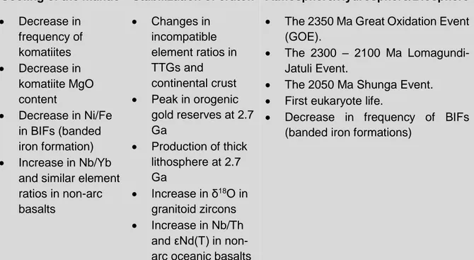
Cooling of the mantle Stabilization of craton Atmosphere/Hydrosphere/Biosphere
Decrease in frequency of komatiites Decrease in komatiite MgO content Decrease in Ni/Fe in BIFs (banded iron formation) Increase in Nb/Yb
and similar element ratios in non-arc basalts Changes in incompatible element ratios in TTGs and continental crust Peak in orogenic gold reserves at 2.7 Ga Production of thick lithosphere at 2.7 Ga Increase in δ18O in granitoid zircons Increase in Nb/Th and εNd(T) in non-arc oceanic basalts
The 2350 Ma Great Oxidation Event (GOE).
The 2300 – 2100 Ma Lomagundi-Jatuli Event.
The 2050 Ma Shunga Event. First eukaryote life.
Decrease in frequency of BIFs (banded iron formations)
Table 1.1: Summary of the events in the Late Archean – Early Paleoproterozoic (See (Condie, 2015) for an exhaustive review).
22
1.1.1 Earth’s Atmosphere, Hydrosphere, and Biosphere
The Paleoproterozoic atmosphere was certainly different from today. Indeed, at ca. 2350 Ma the oxygen level increased sharply during an event well-known as the Great Oxidation Event (GOE). Oxygen then becomes free in the atmosphere for the first time on Earth and could be present at the surface of the ocean (but deep ocean stayed anoxic) (Figure 1.1.A) (Holland, 2006). The first presence of oxygen in the atmosphere is marked by the appearance and deposition of redbeds (oxidized fluvial deposits), an increase of evaporate sulfates, and manganese deposits. Presence of atmospheric O2 is also marked by the disappearance of major deposits of uraninite-pyrite and banded iron formations (BIFs). The end of the BIF’s deposition at ~1880 Ma would suggest the oxidation of the deep oceans (Holland, 1984), whereas an alternative model would suggest the development of sulphidic deep oceans (H2S), the “Canfield Ocean” (Canfield, 1998) (Figure 1.1.C). BIFs “sensu lato” are divided into two groups with different textures, the BIFs “sensu stricto” are dominant in the Archean whereas
GIFs (Granular iron formations) is much common in Paleoproterozoic after GOE, which would suggest different environment and depositional process (Bekker et al., 2010). During the Proterozoic, most studies consider the presence of two O2 concentration upsurges without intermediate variations, the first at ca. 2350 Ma (GOE event) and a second at ca. 850 Ma during the Neoproterozoic (Bao et al., 2008; Lyons et al., 2014). Increase of oxygen in the atmosphere has important implications on the sulfur isotope fractionation. We have indications that the sulfur cycle during Archean times was different before the GOE, characterized by a mass-independent signal. We can explain this behavior with low concentration of O2 in the atmosphere coupled with photochemical reactions on SO2 (Farquhar et al., 2000). After ~2450 Ma the signal was greatly dominated by mass-dependent fractionations (Figure 1.1.B) (Johnston, 2011).
After the Archean – Proterozoic transition, the sedimentary rocks on all continents have recorded the largest positive carbonate carbon isotope excursions with δ 13C values between + 5 and + 16 ‰ (Figure 1.1.B). This excursion is referred to the Lomagundi-Jatuli Event which lasted from 2300 Ma up to 2100 Ma (Martin et al., 2013). Its role and association with the Great Oxidation Event are not well understood and require more consideration. Mechanisms to explain a positive excursion of δ 13C imply increase in organic carbon burial rates (changes in chemistry of ocean or methanogenesis) or more acidic weathering conditions with increase in biological productivity (Schrag et al., 2013). Following the Lomagundi-Jatuli Event, the Shunga Event at ca. 2050 Ma occurred relatively close in time. We can observe this event in the Onega Basin (Fennoscandia) or in the Francevillian Group (Gabon). This event records the largest burial in carbon which form huge volume of sediments rich in carbon (giant petrified oil field)
23 (Melezhik et al., 2009). Asael et al. (2013) associate this event with a severe decrease in oceanic oxygenation.
Fluctuations in the Precambrian paleoclimate is marked by the presence of paleoclimatic indicators. Laterites and bauxites are geological markers for hot/humid climates. Eolian sandstones and evaporites are indicators for arid climate but not always for hot or warm weathers. Redbeds are rather indicators for semi-arid to arid climate. Diamictites, tillites, glacial pavement, striated rocks, and dropstones are good indicators for widespread cold climates. Major glaciations could have occurred at ca. 2400 – 2200 Ma, the so-called Huronian glaciations. The low-latitude position for the Superior craton (Laurentia) at that time suggests an episode of snowball earth and/or high obliquity (Evans et al., 1997) (Figure 1.1.C). Figure 1.1: A: Evolution of Earth’s atmospheric oxygen content through time according Lyons et al. (2014). Two models are illustrated: the red curve show two sharp steps for the rise of the oxygen and the blue curve is the emerging model with more fluctuation. Blue arrows are possible rise of O2 in the atmosphere. B: Summary of
carbon (black) and sulphur (red and grey) isotope data in Earth History (Lyons et al., 2014). C: Two models for the oxygenation of the ocean with the model 1 of Holland (2006) and the model 2 of Canfield (1998) with anoxie until 540 Ma. Glaciations and possible snowball earth are represented. Eukaryotes and metazoans apparitions are indicated.
24 Glaciation also occurred at ca. 1800 Ma in NW Australia, as denoted by the glaciogenic King Leopold Sandstones (Kimberley Basin), and paleomagnetic data suggest this glaciation also occurred at low latitudes (Williams, 2005). Some authors proposed that the observed oxygen rise occurred as a consequence of the deglaciation of the two snowball earth episodes, at ~2200 Ma and ~750 Ma (Harada et al., 2015; Kirschvink et al., 2000; Kopp et al., 2005).The absence of BIFs, glaciations and isotopic fluctuations in the period between 1850 Ma and 850 Ma has been referred to as the “Boring billion” or the “Barren billion” period (Young, 2013) (Figure 1.1).
Precambrian times were a crucial period for the diversity of life and in addition of fossils record (rare or absent for these ages) we can use the geochemistry to reconstruct the history of life (Knoll et al., 2016). Recently, Jackson (2015) used the manganese – iron (Mn/Fe) ratio
- as proxy of the oxidation-reduction potential (Eh) in non-detrital marine sediments (cherts, dolomite,...) at the time of deposition to quantify biological evolution and observe variations with time (Figure 1.2). Fe oxides precipitate more easily than Mn. So a high Mn/Fe suggests an oxidizing setting during the deposition of the sediment (for a constant pH). High values at
ca. 3416 Ma (localized oxidation by cyanobacteria) is supported by a prokaryote life in Archean
times with production of stromatolites. Early fossil record is registered from the Apex chert basalt at ca. 3460 Ma in Australia (Brasier et al., 2015). The ratio decreases until a minimum between 2500 – 1880Ma (Supposed age for the Gunflint Fm. - Superior craton). Major change at ca. 1880 Ma would reflect the accumulation of O2 in the atmosphere, which coincides with the evolution of first eukaryotic photoautotrophs (algae) and eukaryotic primary consumers fossils. Fossils record is very well preserved in the 1880 Ma Gunflint chert (Brasier et al., 2015). The increase of Mn/Fe ratio between 1880 – 800 Ma suggests gradual evolution in natural process (eukaryotes evolution and O2 concentration) until the last upsurge in O2 in atmosphere during the Neoproterozoic (800 – 680 Ma). This gradual evolution changes the general view that oxygen levels in Mesoproterozoic is low and without significant fluctuations. Besides,
Mukherjee and Large (2016) have also reported a possible oxygenation event around ~1400 Ma. Oxygenation of the atmosphere and hydrosphere could have boosted the evolution of eukaryote and the rise of metazoans (Margulis et al., 1976).
25 Figure 1.2: Diagram of Jackson (2015) showing variation in the Mn/Fe ratio (proxy for the oxide-reduction) in non-detrital sedimentary rocks (chert dolomite) through time.
1.1.2 Cooling of the mantle and crustal evolution
All changes described above seem to be tied directly or indirectly to the cooling of Earth’s mantle. This reflects also in a gradual change in the Earth tectonics.
Thermal model for the mantle evolution through time
The thermal History of the Earth is controlled in first approximation by a balance between internal heating by radioactive elements (232Th (44%), 238U (39%), 40K (15%) 235U (2%)) in the mantle (H), and the surface heat loss by mantle convection (Q), following the formula (Christensen, 1985):
𝐶𝑑𝑇𝑖
𝑑𝑇 = 𝐻(𝑡)− 𝑄(𝑡)
Where C is the heat capacity of the whole Earth, Ti is the average mantle temperature, and (t) is the
time.
We can approximate the evolution of the internal temperature, Ti, using the notion of mantle potential temperature, Tp, which is the temperature expected at the surface after correcting for adiabatic cooling (See Korenaga (2013) for a review). With the knowledge of half-lives of relative abundance of radioactive elements we can estimate the past values H (t). Q (t) is more problematic because different scenarios are possible following the modalities of the
26 convection. Usually the mantle heat flux is considered as a function of Tp, noted as Q (Tp). The Urey ratio (Ur), can describe the heat balance and is defined as (Korenaga, 2008):
𝑈𝑟 =𝐼𝑛𝑡𝑒𝑟𝑛𝑎𝑙 ℎ𝑒𝑎𝑡 𝑝𝑟𝑜𝑑𝑢𝑐𝑡𝑖𝑜𝑛 𝑆𝑢𝑟𝑓𝑎𝑐𝑒 ℎ𝑒𝑎𝑡 𝑓𝑙𝑢𝑥 =
𝐻 𝑄
Estimation for the present value for the convective Urey ratio, Ur (0), is 0.23 ± 0.15 (Korenaga,
2008). With a ratio of ~0.3 (< 1), it is logical to assume that Earth cools over time and that the mantle was warmer in the Archean and Paleoproterozoic. But by extrapolating this ratio in the past, we reach too high and unrealistic temperatures for the mantle at times before 2000 Ma, this would be the so-called “thermal catastrophe” (Christensen, 1985) (Figure 1.3.A). To avoid this problem, researchers have assumed a higher Urey ratio as 0.7 – 0.8 (Figure 1.3.A) (Davies, 2009; McGovern and Schubert, 1989) but these values are not compatible with the budget of decay of radioactive elements (Ur ~0.3) which is constrained by the chemical composition of the Earth.
We have very little evidence on the mantle temperature in the past. Herzberg et al. (2010) have calculated the mantle potential temperature Tp using non-arc basalts of Archean and Proterozoic ages. They found a maximum temperature of 1500 – 1600°C at ca. 2500 – 3000
Ma (1350°C is the estimation today – see Figure 1.3.B) to form these primary magmas. Non arc-basalts are therefore indicative of a warmer ambient mantle. Besides, higher Tp of komatiites (1600 – 1780°C) is consistent with plume model conditions. Petrological estimations are consistent with low Urey ratio of ~0.34 and supports an onset of plate tectonic between 2 and 3 Ga (Figure 1.3.B). Shirey and Richardson (2011) propose that lithospheric subduction in the sense of modern plate tectonics appeared at ca. 3 Ga after the nature of mineral inclusions in Archean diamonds.
In the Korenaga’s model, the onset of plate tectonics at ca. 1 Ga would imply a too cold mantle
to produce the non-arc basalts and seems unlikely. So the onset of plate tectonics was likely gradual in the early Earth (> 2500 Ma). Moreover geodynamic modeling suggests that Earth may have begun as a hot stagnant-lid and evolved through an episodic transitional state into plate tectonics over 1 – 3 Ga (O’Neill et al., 2016) (Figure 1.3.B).
More realistic models use non-classical behavior for mantle convection with (1) difference in the rheology of the lower mantle (Solomatov, 2001), (2) dehydration stiffening upon mantle melting in the upper mantle (Korenaga, 2006), (3) the gradual hydration of the whole mantle (Korenaga, 2011). To evaluate the effect of water we can consider an open-system evolution where the net water content in the mantle can vary over time, or a close system evolution where this content is constant (Figure 1.3.C).
27 The Archean mantle is thus hotter but also drier than today. The first implication is to produce a thicker oceanic crust (~30 – 35 km) that contrasts with the current oceanic crust thickness of 7 km. This thicker dehydrated lithosphere implies a lower difference of relative viscosity with the asthenosphere than today. Subduction is the main process for the hydration of the mantle. A drier mantle than today could imply more voluminous oceans and the immersion of continents during the Archean (Korenaga, 2011). Indeed, the bulk silicate Earth (BSE) contains approximately one ocean of water within the crust and the mantle. A drier asthenosphere has a lower viscosity in comparison to the lithosphere. Finally, a hotter mantle implies a thicker lithosphere which slows down the plate tectonics because the process of subduction is more difficult. Mantle hydration facilitates the establishment of plate tectonics throughout Earth’s history (Korenaga, 2013).
Geological evidence for the decrease in mantle temperature
Komatiites are olivine spinifex-textured ultramafic rocks (> 18 wt.% MgO, 40 – 45 wt.% SiO2, < 1 wt.% TiO2, low incompatible trace element concentrations) (Nisbet and Arndt, 1982). They result from melting under extreme conditions of the mantle (> 1600 °C). There is an intense debate if the komatiites are derived from a dry and hot mantle with the partial melting of super-hot Archean plumes (Berry et al., 2008) or derived from the melting under hydrous conditions of the mantle at lower temperature in the context of subduction (Parman and Grove, 2005). Recently, Sobolev et al. (2016) showed that the low oxygen fugacity is inconsistent with a subduction setting and confirm a plume origin for komatiites with a hydrous reservoir in the deep mantle. The gradual decrease in frequency for the komatiites at the end of the Archean (Isley and Abbott, 1999) is considered as a decrease of the mantle temperature through time Figure 1.3: Thermal evolution modeling modified from Korenaga (2013). (A) Evolution of mantle heat production (H in red) with low present-day Urey ratio (0.34) and Ur (0.84) related to the potential mantle temperature, Tp. (B)
Evolution of mantle heat flux (Q in blue) during the transition between a stagnant lid convection toward a plate tectonics convection (simulation at 3 Ga, 2 Ga and 1 Ga) with the relation to the potential mantle temperature, Tp.
(C) Thermal evolution modeling with the effect of water in plate tectonics in open-system or close-system. Solid circles denote petrological estimates on past potential temperature (Herzberg et al., 2010).
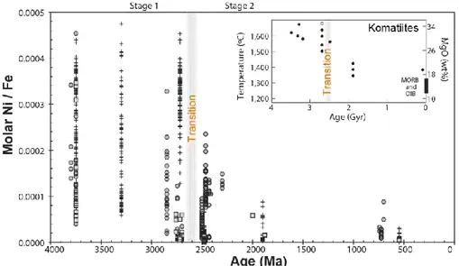
28 (Figure 1.4.A). We can note that the last pulse for Precambrian komatiites is at ca. ~1880 Ma. In the Late Cretaceous (~90 Ma) ultramafic and mafic lavas of the Gorgona Island (Colombia) are identified as komatiites (Gansser et al., 1979) and is a geological peculiarity witnessing the existence of a Cretaceous superplume.
Figure 1.4.B represent the average (red squares) in MgO content for komatiites (purple dots) from a given greenstone belt (Condie et al., 2016). The decrease in the average MgO content at the end of the Archean (after 2500 Ma) could reflect a decrease in mantle temperature as viewed previously in the model of Korenaga (2013).
Figure 1.4: Komatiites through time. A: Time series of occurrences of komatiites modified after Isley and Abbott (1999). B: Secular variation in MgO in komatiites (Condie et al., 2016). In purple – MgO content; In red – aveage MgO content with respective error bars.
29 The decrease in Ni/Fe ratio in BIFs (banded irons formations) is also associated to the reduction of komatiites frequency (Figure 1.5). Because komatiites frequency decreases, the Ni content into the ocean is reduced and the decrease of the Ni/Fe ratio in BIFs can be associated with a global decrease in mantle temperature (Konhauser et al., 2009).
Increase in incompatible element ratios such as Nb/Yb (Figure 1.6) in non-arc oceanic greenstone (basalts) is visible after 2500 Ma, which also implies a decrease in the degree of partial melting, and so a decrease in mantle temperature (Condie and O’Neill, 2010).
Figure 1.6: Nb/Yb through time in non-arc oceanic basalts modified from Condie and O’Neill (2010). Figure 1.5: Ni/Fe mole ratios for iron banded formation (BIF) through time after Konhauser et al., (2009). Inset: Evolution of the temperature is deduced by calculation of the MgO content of komatiite liquids (T°C = 1000 + 20MgO).
30
1.1.3 Stabilization of cratons
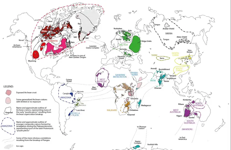
Figure 1.7: Localization of the different cratons in the world, modified from Ernst et al. (2013a).
The Precambrian rocks exposed on the Earth’s surface are found primarily on the cratons (Figure 1.7). The cratons (or “shields”) are stable areas of continental crust with a thick continental lithospheric mantle, named SCLM ("Subcontinental lithospheric mantle") with a thickness of 250 km. The SCLM is a peridotitic mantle root highly melt-depleted, and cold. A low density for this keel allows to the cratonic lithosphere to be significantly buoyant relative to the asthenosphere. The formation of the SCLM is a matter of debate in the literature but it is accepted that the cratonic roots are formed before 2500 Ma and would be remained “cold and stable” until today. We can know the age of the SCLM by investigating the Re-Os isotopic system of mantle xenoliths in kimberlites. Os is compatible in relation with Re, so Os is retained in the Re-poor residue and Re is evacuated in the melt. Re-Os depletion ages from mantle xenoliths suggests that the thick SCLM was formed before 2500 Ma with a peak at ca. 2700 Ma (Carlson, 2005). Many studies on mantle xenoliths show that the SCLM can be refertilized by episodic events. The North China Craton (NCC) is one of the most typical example because the SCLM was almost destroyed during the Paleozoic (Gao et al., 2002). Recently, Liu et al. (2016b) showed that the Rae craton was formed at ca. 2700 Ma (Laurentia – North America),
31 and suffered an episodic refertilization during the Paleoproterozoic 1770 – 1700 Ma Kivalliq-Nueltin event which can explain the layered structure for the SCLM.
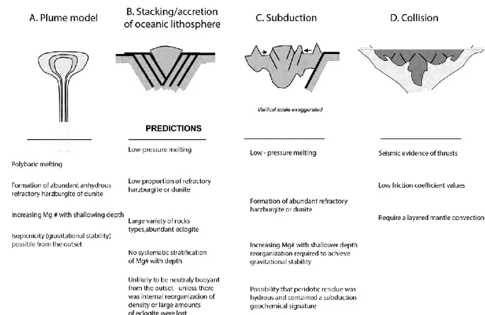
The models proposed for the SCLM formation can be included in 4 categories (Figure 1.8): (1) high-degree melting of a plume head (> 1650°C) (Lee, 2006), (2) slabs stacking, (3) subduction zone, and (4) continental collision. Formation by plume was reviewed by Arndt et al. (2009) who propose a compositional stratification in a very hot plume (~1700 °C) with the Fo-rich olivine (forsterite) ± orthopyroxene in the upper parts of the melting zone. The partial melting is possible in the range of pressures up to 7 GPa. Denser (more fertile) material with Fe-rich olivine ± garnet is ejected of the system by gravitational redistribution.
Formation through accretion of different slabs of oceanic lithosphere (slabs stacking) is consistent with shallow conditions for the partial melting (~4 GPa) and lateral accretion would imply a greater amount of eclogite.
Figure 1.8: Models for the formation of the subcontinental lithospheric mantle (SCLM) adapted from Lee (2006).
Another model suggest the formation of the SCLM in the mantle wedge above a subduction zone (Simon et al., 2007). Transformation of fertile peridotite in more refractory harzburgite or dunite is induced by partial melting with fluids related to the subduction. The thickening of 200 km is induced by deformation during the accretion. In this model redistribution of lithologies is
32 needed to produce a gravitationally stable configuration with the ejection of the large quantity of eclogite. The problem of this model is the efficiency of the partial melting to produce the necessary material.
The last model implies the “continental” collision. Cooper et al. (2006) conducted numerical simulations and they show the possibility to form the cratonic lithosphere by thrust stacking over conductive downwelling. Gray and Pysklywec (2010) have studied the thickening of the lithosphere depending on the composition of the crust and the degree of radioactive (heat production). They show three modes to deform the lithosphere, which are imbrication (weak crust and low radioactive), underplating (lower crust strong) and pure-shear thickening (high temperature by radiogenic heat production).
Among these four models, the plume model (Arndt et al., 2009) and the collision model seem to have the fewest number of problems.
Continental growth and evolution of the continental crust
Formation and thickening of the cratons early in the Earth’s History are crucial parameters to know how the continental growth evolved. Continental growth is the net grain in mass continental crust per unit time (balance production/recycling).
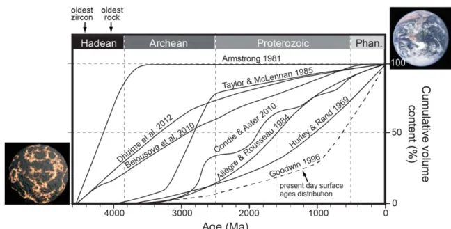
Figure 1.9: Crustal growth models for the continental crust, adapted from Cawood et al. (2013).
Models of growth of the continental crust are based on age and radiogenic isotopic data on rocks and minerals. Different methods imply a range of models on the rate of growth of the continental crust (Figure 1.9). Since the formation of the Earth, most models indicate that the continental crust has increased in volume and area with time (Allègre and Rousseau, 1984;
33
Armstrong and Harmon, 1981; Armstrong, 1991; Belousova et al., 2010; Dhuime et al., 2012;
Fyfe, 1978; Hurley et al., 1962; Hurley and Rand, 1969; Taylor and McLennan, 1985; Veizer et al., 1979, 1985). Armstrong and Harmon (1981); Armstrong (1991) proposed an early burst of continental growth during the Hadean, followed by steady-state or decreasing thereafter. This suggests a process for recycling the crust with time to maintain a constant volume. Most models in Figure1.9 favor continuous growths, and more recently an episodic growth with pulses was also proposed (Condie and Aster, 2010). Dhuime et al. (2012) proposed two stages to explain the continental growth: a rapid production of ~65% of the current volume prior to 3000 Ma, followed by a slower production due to the recycling process on Earth (plate tectonics with subduction zones).
Recently, Nicoli et al. (2016) proposed a new model that attempts to take into account the thermal evolution over time (Figure 1.10). Brown (2006) compiled a database for the metamorphic conditions through time. During the Archean granulite-ultrahigh temperature metamorphism (G-UHTM) predominated in contrast with modern gradients with high pressure – ultrahigh pressure metamorphism (HPM-UHPM). Nicoli et al. (2016) used these data to constrain an apparent metamorphic gradient and calculate a burial rate (km.Ma-1) for each craton since 4000 Ma. Burial rates correspond to the crustal shortening and give an indication on the velocity for recycling and tectonic regime. Before 3000 Ma a large range of burial rates associated with a large variety of geodynamic mechanisms (vertical/sagduction and different horizontal displacements) were proposed. After ca. 3000 Ma, recycling became dominant on Figure 1.10: Evolution for crustal processes modified from Nicoli et al. (2016). The Archean – Proterozoic transition shows the first evidence for continental collisions in convergent settings wth the onset of plate tectonics. Ar-Pr = Archean – Proterozoic transition. Pr-Ph = Proterozoic – Phanerozoic transition. PT = Onset for the plate tectonics in this model.
34 Earth in convergent settings and the geodynamic diversity decreased until the modern duality subduction-collision. The Proterozoic is a period with long-lived accretionary orogens (100 – 700 Ma) with a good potential for the recycling and reworking of the continental crust. In this period a large amount of examples for mixed orogens, hot orogens and ultra-hot orogens can be observed (Chardon et al., 2009). The transition Archean – Proterozoic (Ar-Pr) is consistent
with the onset of continental collision (CC) but modern collision would start predominantly on Earth at the Proterozoic – Phanerozoic (Pr-Ph) transition.
The evolution of the continental crust through time is characterized by major changes in composition. The crust evolved from a highly mafic bulk composition before 3000 Ma to a more felsic bulk composition (Tang et al., 2016). Archean crust is represented by mafic greenstone belts and large felsic granitoids grouped into four categories (Laurent et al., 2014): (1) TTGs (Tonalite – Trondhjemite – Granodiorite) (Moyen and Martin, 2012), (2) Sanukitoids, which are metaluminous (monzo) diorites and granodiorites, (3) Biotite- and two-mica granites, (4) Hybrid granitoids.
The origin of dominant TTGs may be related to melting of a hot subducted slab (like adakitic magma) as described by the classical model of (Martin, 1986). Other models are possible, like melting at the base of a thick oceanic crust, subduction of oceanic plateaus (Hastie et al., 2016) or delaminated portions below a plateau (Bédard, 2006). Alternatively, new models suggest their origin by proto-collision zones in Archean tectonics by melting of hydrated mafic rocks (Moyen et al., 2016). Sanukitoids (< 15% in proportion in the continental crust) are derived from interaction/hybridization between a mantle peridotite and a component rich in incompatible elements. We can cite as sanukitoid, the Rio Maria granodiorite (Carajás Province) dated at ca. 2870 Ma as we will see later (Santos and Oliveira, 2016). Biotite- and two-mica granites are crustal-derived granites (partial melting from TTGs and/or metasediments). The hybrid granitoids form a heterogeneous group that contains all kind of intermediate granitoids that cannot be strictly associated to the first three groups. Therefore, they result from interaction (mixing, mingling, or metasomatism) of sources and magmas.
Laurent et al. (2014) proposed a long-stage (up to 500 Ma) evolution up to late-Archean granitoids: TTGs formation followed by a short-stage (< 50 Ma) of sanukitoids formation and late crustal granitoids (Figure 1.11). Although diachronic, this evolution is the same in cratons worldwide before 2500 Ma.
35 Figure 1.11: Model of Laurent et al. (2014) for the evolution of the granitoids during the Archean (after 3000 Ma).
Proterozoic granitoids
Evolution of the continental crust after the Archean – Proterozoic transition is marked by the absence of TTGs. In Figure 1.12, decrease in La/Yb suggest decrease in garnet content, therefore a gradual change in the source of granitoids after 2500 Ma. Nevertheless, rare presence of granitoids with TTG-affinity was observed between 2200 – 2150 Ma during the early stages of the Eburnean orogeny in West Africa within the gradual evolution of the continental crust and this suggests episodic returns to Archean conditions (Dioh et al., 2006).
36 We observe the dominance of a distinctive magmatic suite specific to the Proterozoic times. The rapakivi granite suites and associated rocks are typical examples of the rocks formed during the Proterozoic times in all cratons and these granites are generally classified as A-type granite (Loiselle and Wones, 1979). The anorthosite, mangerite, charnockite, alkali-feldspar (Rapakivi) granite (AMCG suite) and associated mafic rocks occurred closely in both space and time (Rämö and Haapala, 1995). The Finnish rapakivi granites (Fennoscandia – Baltica) were intruded into the Paleoproterozoic (1900 – 1800 Ma) (Andersen et al., 2009) and during the Mid-Proterozoic in two stages at 1650 – 1620 Ma and 1590 – 1540 Ma (Heinonen et al., 2015). We can observe the same duality in age for the Amazonian craton between the A-type granites of Carajás dated at ca. 1880 Ma (Dall'Agnol et al., 2005) and the A-type granites in the southwestern of the craton dated between 1600 – 1400Ma (Sadowski and Bettencourt, 1996). The petrogenetic relationship in the AMCG suite is controversial (Bonin, 2007). The comparison of geochemical data between different lithologies for the North China Craton (NCC) showed that they have different magmatic sources and petrogenetic histories (Liu et al., 2016a). The system is constituted by the anorthosites (A) and norites with magmas from the enriched mantle (fractional crystallization in the lower crust at ~1300°C). The mangerites (M) and charnockites (C) could be related from the partial melting of the lower crust induced by underplating of mafic magmas. The rapakivi granites (G) would be formed by partial melting in the mid/upper crust in shallowing conditions (Figure 1.13.B). Two geological contexts are proposed to form the AMCG suite with an intracontinental rift setting related to the break-up of the Columbia/Nuna supercontinent or in a post-collisional/post-orogenic tectonic setting. The relation between the AMCG suite and the Columbia/Nuna supercontinent was studied by Vigneresse (2005) who proposed a progressive warming of the lithosphere by amalgamation and concentration of zones of juvenile crust during the rotation of the Columbia supercontinent.
In summary, the evolution of the felsic composition of the continental crust can represent the secular decrease of mantle temperature. The evolution from TTG followed by the sanukitoid suite is characteristic of the hot Archean conditions whereas AMCG suite during the Proterozoic could represent a transitional stage before reaching modern conditions (Figure 1.13) (Nédélec and Bouchez, 2015).