Quantitative analysis of non-cooperative
transboundary river basins
Thèse
Nicolas Avisse
Doctorat en génie des eaux Philosophiæ doctor (Ph. D.)
Québec, Canada
Quantitative analysis of non-cooperative
transboundary river basins
Thèse
Nicolas Avisse
Sous la direction de:
Résumé
Le partage de l’eau dans des bassins versants transfrontaliers est un problème complexe, en particulier lorsqu’il n’y a pas de tradition de coopération entre les pays riverains dans d’autres domaines non liés à l’eau tels que le commerce. De plus, à mesure que les ressources en eau se développent et que le changement climatique est une nouvelle source de risque, le manque d’informations partagées quant aux débits hydrologiques et aux décisions humaines et institutionnelles sur la gestion des ressources rend de plus en plus difficile la distinction entre facteurs naturels et anthropiques dans le dérèglement d’un régime hydrologique.
Des tentatives de récupération de données hydrologiques dans des régions difficiles d’accès ont été réalisées avec succès en utilisant la télédétection. Mais l’application de cette technique pour la modé-lisation des systèmes d’eau (notamment pour caractériser des infrastructures ou des comportements d’usagers) reste difficile puisqu’elle nécessite d’importantes observations et interactions avec les ges-tionnaires de la ressource sur le terrain. La portée de la plupart des techniques de modélisation est également limitée par leur incapacité à gérer la multitude d’institutions en charge des ressources en eau, ou l’impact de leurs intérêts spécifiques et souvent opposés sur la ressource en elle-même. Pen-dant des décennies, ce manque de données détaillées et de techniques de modélisation appropriées a conduit de nombreuses études sur des bassins versants internationaux non gérés de façon concertée à rester qualitatives ou conceptuelles. Cette incapacité à comprendre et à quantifier de manière indé-pendante les causes de changements hydrologiques est particulièrement frustrante pour des décideurs politiques.
Dans le bassin du Yarmouk, par exemple, qui est partagé entre la Syrie, la Jordanie et Israël, le débit annuel moyen correspond aujourd’hui à moins de 15 % de celui qui a précédé la période de dévelop-pement, et ce malgré la signature d’accords bilatéraux entre la Syrie et la Jordanie (1987) et entre la Jordanie et Israël (1994). Cette situation a conduit les pays riverains à développer chacun leur propre théorie, contestée, concernant l’effondrement du débit du Yarmouk.
En prenant ce bassin comme étude de cas, cette thèse de doctorat vise à analyser quantitativement des changements hydrologiques dans des bassins versants transfrontaliers, non gérés de façon concer-tée, complexes institutionnellement, et aménagés à l’excès. Cet objectif passe par deux activités de recherche principales : (i) le suivi de la retenue d’eau de petits barrages dans des zones inaccessibles – comme première étape à la caractérisation d’un système multi-réservoirs ; et (ii) la simulation et
l’analyse de scénarios, dans le but d’étudier de manière quantitative des changements hydrologiques dans un bassin versant. Les résultats indiquent que des facteurs naturels et anthropiques sont res-ponsables de la chute du débit du Yarmouk et évaluent leur contribution à cet effet en combinant télédétection, simulation multi-agent et analyse de scénarios.
Abstract
Sharing waters in a transboundary river basin is challenging, especially when there is no tradition of cooperation between riparian countries in other, non water-related, issues such as trade. Moreover, as water resources are being developed and climate change is a new source of risk, the lack of shared information on hydrological flows and human/institutional decisions on resources management im-plies that it is increasingly difficult to distinguish between natural and anthropogenic factors affecting a flow regime.
Attempts to retrieve hydrological data in hardly accessible areas have successfully been made using remote sensing. But the use of this technique for water systems modeling efforts, and particularly for characterizing infrastructure or understand water user behaviors, remains challenging as it requires extensive on-the-ground observations and interactions with water resources managers. The scope of most modeling techniques is also limited by their inability to handle the multiplicity of institutions dealing with water, or the impact of their specific and often competing interests on water resources. For decades, this lack of detailed data and suitable modeling techniques has led many studies on non-cooperatively managed international river basins to remain qualitative or conceptual, and has therefore frustrated policy makers for not being able to independently understand and quantify the causes of hydrological changes.
In the Yarmouk River basin, for example, which is shared between Syria, Jordan and Israel, the annual outflow now corresponds to less than 15% of that of pre-development era, despite the signature of bilateral agreements between Syria and Jordan (1987), and between Jordan and Israel (1994). This state of affairs has led riparian countries to develop their own, contested, narratives regarding the collapse of the Yarmouk flow.
Taking the Yarmouk basin as a case-study, this Ph.D. thesis consequently aims at quantitatively an-alyzing past hydrological changes in non-cooperatively managed, institutionally complex, over-built, transboundary river basins. This objective goes through two main research activities: (i) the monitor-ing of small reservoirs’ storage in inaccessible areas, as a start to characterize a multi-reservoir system; and (ii) the simulation and analysis of scenarios to quantitatively study changes in a river basin. Re-sults reveal that the contributions of natural and anthropogenic factors to explain the decline of the Yarmouk flows can be identified and then assessed using remote sensing, multi-agent simulation, and scenario analysis.
Contents
Résumé iii
Abstract v
Contents vi
List of Tables viii
List of Figures ix
Preface xi
Introduction 1
0.1 Jordan Water Project – Analysis of Freshwater Resources Sustainability in Jordan 1
0.2 Ph.D. context and objectives . . . 2
1 Current context and issues 5 1.1 Water scarcity . . . 5
1.2 Common pool resources . . . 7
1.3 Managing shared water resources. . . 8
1.4 Circumventing the lack of data . . . 10
2 Case study: the Yarmouk River basin 17 2.1 Historical and hydrological background . . . 17
2.2 Bilateral agreements . . . 19
2.3 Agricultural development policies in Syria . . . 20
2.4 Challenges to quantitatively analyze the basin . . . 21
3 Methodology 22 3.1 Remote sensing . . . 22
3.2 Multi-agent simulation . . . 24
3.3 Application to the Yarmouk River basin . . . 25
4 Results and discussion 43 4.1 Remote sensing . . . 43
4.2 Historical flows . . . 48
4.3 Scenarios over the historical period. . . 50
Conclusions 55
Bibliography 58
A Monitoring small reservoirs’ storage with satellite remote sensing in inaccessible
areas 71
B Quantitative analysis of contested water uses and management in the conflict-torn
Yarmouk basin 87
C A New Temperature-Vegetation Triangle Algorithm with Variable Edges (TAVE)
for Satellite-Based Actual Evapotranspiration Estimation 98
D Impact of the Syrian refugee crisis on land use and transboundary freshwater
re-sources 100
List of Tables
1.1 Global distribution of the world’s water. . . 5
1.2 Conventional definitions of water stress levels. . . 6
1.3 Types of goods depending on the level of rivalry and excludability. . . 7
1.4 A water management game: the Prisoner’s Dilemma. . . 13
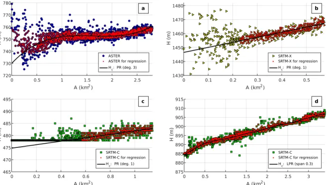
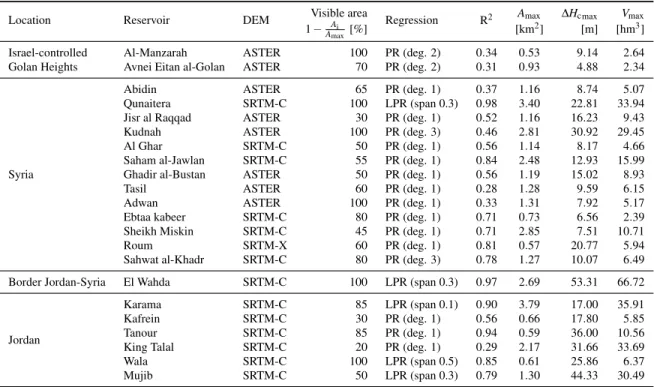
3.1 Parameters and results of the elevation–area regression. . . 32
3.2 Dams considered in the modeling. . . 42
4.1 Errors in terms of R2and NRMSE for Jordanian reservoirs’ H cand V assessments. . 47
4.2 Initial Fmask classification inside the final water areas , and stages’ percentage changes that led to the classification as water. . . 47
4.3 Consequences of each scenario on the transfers as per the 1994 Treaty of Peace be-tween Israel and Jordan. . . 53
List of Figures
0.1 Integrated model considered in the Jordan Water Project. . . 2
0.2 Institutional framework considered in the Jordan Water Project. . . 3
1.1 Physical and economic water scarcity in the world. . . 6
1.2 Risks of conflict in transboundary river basin. . . 8
1.3 Various degrees of cooperation between users/managers in a water resources system. 9 2.1 The Yarmouk River basin as part of the Jordan River basin, with reservoirs detected using remote sensing. . . 18
2.2 Yarmouk River flow at the Wahda dam; and PERSIANN-CDR precipitation upstream that station. . . 19
2.3 Diversion systems downstream from Adasiya. . . 20
3.1 Flowchart of the reservoir storage monitoring procedure. . . 23
3.2 Unified modeling language (UML) diagram of PyNSim. . . 24
3.3 PyNSim simulation workflow. . . 25
3.4 Image of the number of times each pixel has been covered by water (Mocc). . . 27
3.5 2-D dynamic water classification over a part of a Landsat 7 image (174/37) obtained on 30 March 2010. . . 28
3.6 Two-dimensional dynamic classification procedure. . . 29
3.7 Procedure for the statistical correction of topography. . . 30
3.8 Relative non-immersion frequency and elevation in the Kudnah reservoir. . . 31
3.9 Elevation–area relationship and regression for a few reservoirs in the Yarmouk River basin. . . 31
3.10 SWIR-R-G image. Final water bodies as obtained after the 2-D enhancement and the 3-D reconstruction applied to the Landsat 7 image (174/37) taken on 30 March 2010. 34 3.11 Canals and pipes assuring West–East water transfers inside the YRB.. . . 35
3.12 Flowchart of the protocol developed to create the land use map for 2014. . . 37
3.13 Reservoirs, usages, wadis and canals detected in the Yarmouk River basin using re-mote sensing. . . 41
3.14 Schematic of the water resources system considered in this study, and associated multi-agent representation with supervising institutions from each riparian country. . 42
4.1 Land use map of the Yarmouk River basin for 2014. . . 44
4.2 Storage variations in the Syrian and Israeli reservoirs. . . 45
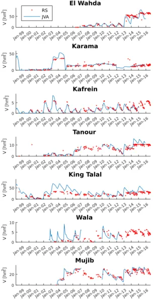
4.3 Storage variations for Jordan-managed reservoirs. . . 46
4.4 Cumulated storage capacity and variations in Syria and the Israel-occupied Golan Heights. . . 48
4.5 Measured flows and simulation results of the historical run at Wahda and Adasiya
stations. . . 49
4.6 Simulation results at the Wahda dam location for the proposed scenarios, and water
year flow difference with the historical run. . . 52
4.7 Simulation results at the Wahda dam location for future scenarios. . . 54
Preface
This Ph.D. thesis presents the research that has been performed between January 2014 and December 2017 at the Water Engineering Department of Université Laval under the supervision of Professor Amaury Tilmant. The work also makes part of a Belmont Forum G8 international project on the
Integrated Analysis of Freshwater Resources Sustainability in Jordan.
The document starts with an introduction of the context and current main challenges related to the management of transboundary water resources, and then gives a summary of the literature review, research activities and main findings conducted and obtained during these four years of research. More detailed information on the work that has been carried out can be found in the following research papers, in which I am first author:
PaperA Avisse, N., Tilmant, A., Müller, M. F., and Zhang, H.: Monitoring small reservoirs’ storage with satellite remote sensing in inaccessible areas, Hydrology and Earth System Sciences, 21, 6445–6459, doi:/10:5194/hess-21-6445-2017, 2017.
Status: published
PaperB Avisse, N., Tilmant, A., Rosenberg, D., and Talozi, S.: Quantitative analysis of contested water uses and management in the conflict-torn Yarmouk basin.
Status: manuscript in preparation
I have also contributed to the following papers through my research:
Supplementary paper 1 Zhang, H., Gorelick, S. M., Avisse, N., Tilmant, A., Rajsekhar, D., and Yoon, J.: A New Temperature-Vegetation Triangle Algorithm with Variable Edges (TAVE) for Satellite-Based Actual Evapotranspiration Estimation, Remote Sensing, 8, 735,
https://doi.org/doi:10.3390/rs8090735, 2016.
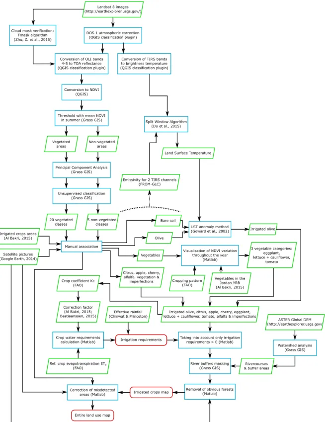
I produced a land use map for southern Syria without any access to ground data. The whole procedure is presented in this thesis in Sect.3.3.4. The quality of the map was very high but the procedure required many cumbersome steps (see Fig.3.12). For these reasons, the land use map was used to calibrate other land use maps for Jordan, and served as a basis for crop assessment. The French version of the abstract is available in AnnexC.
Supplementary paper 2 Müller, M. F., Yoon, J., Gorelick, S. M., Avisse, N., and Tilmant, A.: Impact of the Syrian refugee crisis on land use and transboundary freshwater resources, P. Natl. Acad. Sci. USA, 113, 14932–14937,https://doi.org/doi:10.1073/pnas.1614342113, 2016.
I developed an innovative approach to retrieve storage–area relationships for reservoirs in data-scarce areas, and to characterize the Syrian multi-reservoir system. This work corresponds to earlier stages of the 2-D dynamic classification and Statistical correction of elevation presented in PaperA. The results were not good enough to precisely estimate reservoir storage, but they were perfectly suited for a statistical analysis of storage variations in the Yarmouk River basin. The French version of the abstract is available in AnnexD.
Finally, some of my work has been presented to the following conference oral presentations and posters:
Poster Avisse, N., Lachaut, T., and Tilmant, A.: Consequences of the unilateral management of the Yarmouk waters on transboundary water allocation in the Jordan River basin, Canadian Water Resources Association, Montreal, National Conference 2016.
Oral presentation Avisse, N., Tilmant, A., Zhang, H., Talozi, S., Müller, M. F., Rajsekhar, D., Yoon, J., and Gorelick, S.: Combining Remote Sensing and Multi-Agent Simulation to Assess Alter-native Water Management Policies in Conflict-Prone Areas - The Case of the Yarmouk River Basin, American Geophysical Union, San Francisco, Fall Meeting 2016, abstract #H52F-08. Oral presentation Avisse, N. and Tilmant, A.: Simulation de l’impact de politiques de gestion de
l’eau dans des régions soumises à des conflits ou inaccessibles. Application au Bassin Versant du Yarmouk, Institut Eau Développement Société, Québec, Colloque 2017.
Poster Avisse, N. and Tilmant, A.: Combiner télédétection et simulation multi-agents pour soutenir la conception d’accords internationaux efficaces, Réseau Environnement, Lévis, Symposium sur la Gestion de l’Eau 2017.
Poster Avisse, N., Tilmant, A. and Rosenberg D.: Quantitative analysis of contested water uses and management in conflict-torn transboundary river basins, European Geophysical Union, Vienna, EGU General Assembly 2018.
Introduction
0.1 Jordan Water Project – Analysis of Freshwater Resources
Sustainability in Jordan
This work has been carried out under a larger project – Integrated Analysis of Freshwater Resources Sustainability in Jordan, which has been undertaken in collaboration with different universities: Stan-ford University (USA; lead), Université Laval (Canada), UFZ and Leipzig University (Germany), Manchester University (UK), King’s College (UK), and Jordan University of Science and Technology (Jordan). By gathering engineers, earth scientists and social scientists specialized in fields as various as surface water hydrology, hydrogeology, modeling, programing, remote sensing, system analysis, economics, institution analysis, risk analysis and geography, our objective has been to develop a quan-titative policy-evaluation tool to explore ways to enhance the sustainability of freshwater systems in Jordan (https://pangea.stanford.edu/researchgroups/jordan/).
Through this Jordan Water Project (JWP), we have aimed at building a multi-agent hydro-economic simulation model combining hydrological modules, to represent environmental processes, and human modules, to characterize human and institutional decisions on various hierarchical levels in Jordan and its main neighbors. By simulating a set of potential future scenarios (e.g. climatic or socioeco-nomic changes) and interventions (e.g. demand-side regulation or supply side enhancement), valuable information can be retrieved to support Jordanian managers’ decision making process. Endogenous interactions between human and biophysical modules, and exogenous inputs impacting these modules, are represented in the integrated model representation of Fig.0.1.
The institutional framework of the JWP is shown in Fig. 0.2. As a member of this project, I have worked on an optimization model of the Water Authority of Jordan (WAJ) freshwater distribution net-work (see AnnexE). Most of my activities inside the project, though, have focused on international aspects, i.e. on interactions between Jordan and its riparians with which common pool water resources are shared. In particular, Jordan shares the Jordan River basin with Lebanon, Syria, Israel, and the Palestinian Territories; and the Disi Aquifer with Saudi Arabia. Yet, the part of the basin covering Lebanon is marginal, there is almost no water left in the Jordan River (water resources in the Pales-tinian Territories are by any means mostly managed by Israel), and there is no regulation on water abstractions in the Disi Aquifer but on the quality of its water (Jordan and Saudi Arabia,2015). The
5. Crop Yield Module 2. Urban Modules 3. Agricultural Modules 4. Institutional Modules 7. Surface Water Modules 6. Groundwater Module purchases, deliveries crop choice, water application crop yield Climate Forcings Population, Socioeconomic Characteristics diversions, withdrawals withdrawals water levels flows, storage volumes Non-Jordan Withdrawals Non-Jordan Withdrawals withdrawals withdrawals recharge soil moisture Energy Prices, Environmental flows Biophysical Modules Human Modules
physical processes (endogenous) human decisions (endogenous) scenario inputs (exogenous) LEGEND
Climate Forcings
intervention inputs (exogenous)
regulations, prices, etc. Energy Prices, Crop Prices, Land Area withdrawals
new supply wells
Pipeline capacities, New sources
1. Riparian Modules
transfers, sharing
Figure 0.1: Integrated model considered in the Jordan Water Project (Jim Yoon, Stanford University group).
study of international aspects has consequently focused on Syria and Israel, and I have contributed to the JWP multi-agent simulation model by developing management decisions for Jordanian and Israeli institutions as per their Treaty of Peace (Israel and Jordan,1994).
For these reasons, the Yarmouk River basin, which is shared between the Hashemite Kingdom of Jordan, the Syrian Arab Republic and Israel, has also been taken as a case study for my Ph.D. research.
0.2 Ph.D. context and objectives
One of the main challenges with freshwater resources is to access, transport, and treat these resources at affordable costs to different users. Easily accessible freshwater resources indeed represent only 0.0075% of global water resources on the planet (they are mostly lakes and rivers;Shiklomanov and
Rodda,2003), and the per capita availability of this freshwater keeps decreasing since the beginning of
the 20th century due to population growth, rising living standards, and more recently climate change-induced uncertainties. Such large global changes are prone to increase the share of physically scarce water areas (areas physically lacking of water, which have originally mostly been limited to arid parts of the world); but also of economically scarce areas (areas lacking of financial and institutional resources to connect the supply to the demand) since accessing freshwater requires more and more financial resources.
Ministry of Water and Irrigation
Water Authority of Jordan
Water Resellers Water User Associations
Water Allocations, Reservoir Operation Rules Water Prices, Water Quotas, Crop Rules Farm Level Allocations Water Prices Water Prices GW / Spring Extraction Rules GW / Spring Extraction Rules Ministry of Agriculture Urban Utilities Water Schedules Crop Price Controls, Subsidies Ministry of Environment G ove rnm en t Org a n iz a ti o n s W ater Use rs Flow Requirements Water Prices
Urban Utilities Water Resellers
Ri
pa
ri
an
s
Storage levels & anticipated needs
Israel Lebanon Saudi Arabia Syria
Palestinian Territories
Upstream Water Diversions
Jordan Valley
Farmer Households Urban Households
Highland Farmer Households Jordan Valley
Farmer HouseholdsFarmer HouseholdsJordan Valley
Highland
Farmer HouseholdsFarmer HouseholdsHighland Urban HouseholdsUrban Households IndustriesIndustriesIndustries
Anticipated withdrawals Water exchanges through Lake Tiberias
Jordan Valley Authority
Figure 0.2: Institutional framework considered in the Jordan Water Project (Jim Yoon, Stanford Uni-versity group).
Decreasing freshwater availability is particularly concerning when water resources are shared between different users and usages (common pool resources), and even more when such users and usages are located in different countries with multiple jurisdictions. In the absence of effective transboundary regulation on surface water resources, upstream riparian countries indeed tend to develop and manage their resources unilaterally without considering the potential externalities (i.e. consequences) on their downstream neighbors. Such situation is a challenge for many interdependent countries: 92 among them have more than 50% of their territory within international basins (Wolf,2010). In these basins, sharing information on hydrological flows or human activities (e.g. reservoir storage, water diversion or consumption) is often acknowledged as a first step to cooperation. Unfortunately, because this kind of information is generally considered sensitive, countries are often reluctant to release it to their neighbors.
In this data-scarce context, remote sensing has been extensively used for a few decades to retrieve hydrological data in inaccessible areas, either for monitoring or modeling applications. Its coupling to system modeling has however faced numerous limitations for inaccessible areas, as representing anthropogenic activities such as infrastructure, agricultural policies, or reservoir operation, typically requires extensive in situ observations, surveys and interactions with water resources managers. It must be stressed that most modeling techniques are also limited by their inability to handle the multi-plicity of institutions and decision-makers that are responsible for water management, as well as the interactions between them or with the resource in itself (Dinar and Wolf,1994;Giuliani et al.,2015).
Studies that analyzed transboundary water resources systems have then mostly remained qualitative or conceptual, due to the difficulty to address the above-mentioned issues.
The challenge of this Ph.D. has been to develop a modeling framework for quantitatively analyzing past hydrological changes in non-cooperatively managed, institutionally complex, over-built, trans-boundary river basins. By taking the Yarmouk River basin as a case study, this research has gone through two secondary objectives which are:
1. To characterize the Yarmouk basin’s water resources system, and particularly water stored in the multi-reservoir system (PaperA), using remote sensing data only.
2. To identify and assess the contributions of natural and anthropogenic factors in the decline of the Yarmouk flows, by combining remote sensing, multi-agent simulation, and scenario analysis (PaperB).
This Ph.D. thesis summarizes the findings of my two research papers. Chapter1introduces a litera-ture review on cooperation as a way to effectively share common pool resources, and on alternative approaches that have so far been developed for that matter in transboundary basins when shared in-formation is lacking. Chapter2presents our case study, the Yarmouk River basin, and the particular issues related to the hydrological changes that have affected its riparian countries. The methodology is then described in Chapter 3, the results are discussed in Chapter 4, and followed by concluding remarks on the research conducted in this Ph.D., on its limitations, and on potential future work.
Chapter 1
Current context and issues
1.1 Water scarcity
When focusing on freshwater resources availability issues, one of the main challenges today is to access, transport and treat these resources at affordable cost to different users. Indeed, only 0.0075% of global water resources are considered easily accessible freshwater (i.e. freshwater lakes and rivers; Table1.1).
Moreover, since the beginning of the 20th century, the world is witnessing some rapid transforma-tions that are altering the quantity and quality of water resources. With population growth only, per capita freshwater availability has dropped by more than 60% in the last 60 years (Dinar et al.,2007). Considering industrialization and rising living standards, this availability has then certainly decreased even more.
Falkenmark(1989) defined per capita water availability thresholds to characterize a certain pressure on
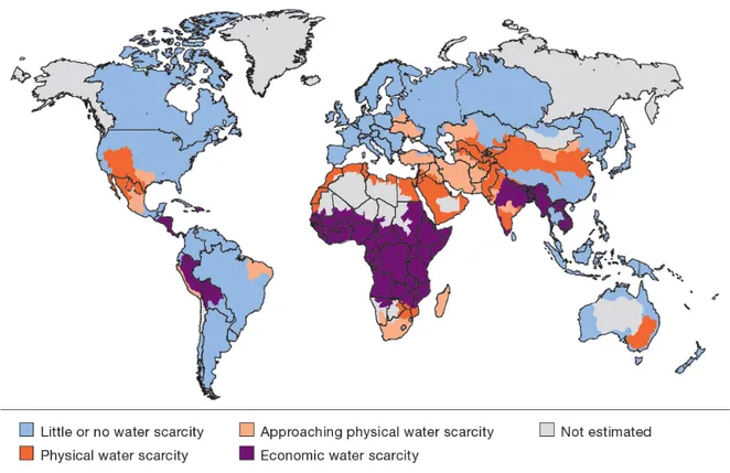
freshwater resources (Table1.2). These thresholds are widely used today to estimate how vulnerable to water a population is. Two types of water scarcity can actually be distinguished: (i) physical water scarcity if not enough freshwater is physically available to meet a population demand, and (ii) economic water scarcity if there is not enough financial and institutional resources to access and to distribute freshwater to satisfy the demand. We can see in Fig. 1.1 that physical scarcity typically affects areas in the Middle East and North Africa (MENA), and economic scarcity affects areas that may receive a lot of precipitation (e.g. Equatorial Africa).
Table 1.1: Global distribution of the world’s water (fromShiklomanov and Rodda,2003). Total water
Saltwater (97.5%)
Glaciers (68.7%) Freshwater Groundwater (30.1%)
(2.5%) Lakes & rivers (0.3%) Other (0.9%)
Table 1.2: Conventional definitions of water stress levels (Food and Agriculture Organization,2012). Renewable freshwater resources Level of water stress
[m3/cap./yr]
< 500 Absolute scarcity 500–1,000 Chronic scarcity 1,000–1,700 Regular stress
> 1,700 Occasional or local stress
Table 1.3: Type of goods depending on the level of rivalry and excludability. A usage is rival if the use of the good from a certain party reduces the availability for others; and it is excludable when the use from a certain party prevents the others from using it.
Rival Non-rival Excludable Private goods Club goods Non-excludable Common goods Public goods
1.2 Common pool resources
The increasing water stress is raising even more concern when water resources are naturally shared between rival but non-excludable uses (i.e. common pool resources; see Table1.3) since some parties are relying on others’ decisions. In the absence of effective regulation, users often tend to unilaterally manage and develop the resources they can access for their own interests without taking into account the potential externalities (i.e. consequences) that will affect others, or the resource in itself. This important issue, better known as the “Tragedy of the Commons”, gained wide popularity withHardin
(1968). In the context of river basins, externalities are most of the time unilateral in the sense that the use from an upstream riparian often affects the availability of downstream users. Therefore, the water management challenge for such basins is often a unilateral externalities problem.
International river basins have particularly been studied as the potential for severe consequences in-creases with the geographical scale of a dispute (Ashton, 2007). The case of such basins is all the more relevant as 276 river basins cross borders around the world, covering 45% of land area (exclud-ing Antarctica;Wolf,2010), gathering 40% of the world population, and 60% of the global freshwater flow (UNEP, 2002). However, the risk for a conflict to occur (Fig. 1.2) is more an issue of water scarcity than of geographical scale (Fig.1.1). The analysis of past international water-related events has indeed shown that violent cases are rare in international basins (Wolf et al.,2003). Water may be a trigger for conflicts, but it is not the only one; and other economic, political, social, historical or environmental aspects need to be considered (Heywood,2012).
For many years, customary law has been a standard to manage transboundary river basins. It comes from state practices and constitutes implicit agreements supposed to bind all countries sharing the resource. Three main doctrines have historically been called for by riparians depending on the river basin configuration, and on their relationships with neighboring countries (Dellapenna,1996;Kliot et al.,2001;UNDP,2006):
Absolute territorial sovereignty also known as Harmon doctrine. This doctrine stipulates that ri-parian countries have exclusive authority on the water flowing down within their territory. In other words, they can manage their waters without considering the effect of potential externali-ties. This doctrine is typically used by upstream countries, and goes in the opposite direction to current international agreements.
Figure 1.2: Risks of conflict in transboundary river basin (Wolf et al.,2003).
Absolute territorial integrity. It maintains that downstream countries have the right to receive an unaltered river flow from their upstream riparians. This doctrine is exactly the opposite of the absolute territorial sovereignty, but it is seen as too constraining for upstream countries to be applied.
Limited territorial sovereignty. This doctrine claims that each riparian country has sovereignty on the water flowing in its territory, as long as it does not cause significant harm to its neighbors. This principle has been taken over in the building of many international agreements.
Most of the time, these doctrines, though, do not have any acknowledged legitimacy across interna-tional river basins. This is the reason why, for a few decades, neighboring countries sharing freshwater resources are more and more encouraged to consider a holistic management of these resources. Man-aging water in an integrated manner at the river basin scale enables parties to “internalize” externalities (Dinar et al.,2007), so that conflicts can be avoided.
1.3 Managing shared water resources
Methods to solve mutual problems in transboundary basins are sometimes separated in three categories
(Jennings et al.,1998): cooperation (i.e. working together towards a common objective), coordination
(i.e. scheduling activities to prevent harmful unilateral decisions and foster beneficial actions), and negotiation (i.e. establishing cooperative arrangements acceptable for all parties). These approaches are however presented as different levels of cooperation characterizing a range of more or less realistic
Full cooperation Intermediate cooperation No cooperation
Figure 1.3: Various degrees of cooperation between users/managers in a water resources system. possibilities depending on the international river basin considered. In this thesis, the word cooperation is used as a standard term to characterize this whole range of possibilities (Fig.1.3).
In a transboundary context, cooperation is often associated to the establishment of international agree-ments (Wolf et al.,2003;UNDP,2006) and to the building of transnational basin-wide organisations
(Ostrom,1990;Kliot et al.,2001). Guidelines were first presented by theInternational Law
Associa-tion(1966) in the Helsinki Rules on the Uses of the Waters of International Rivers. The International Law Commission (affiliated to the United Nations) took over these principles soon after to prepare
theUnited Nations(1997) Convention on the law of the non-navigational uses of international
water-courses. It got approved on 21 May 1997 and entered into force on 17 August 2014 after 35 countries ratified it. The main principles are (UNDP,2006;Dombrowsky,2007):
• The responsibility to use a shared water in an equitable and reasonable way with the aim of reaching “optimal and sustainable utilization thereof and benefits therefrom” (articles 5 & 6). • The duty to not cause any significant harm to riparian parties (article 7). It must be stressed that
this point and the previous one meet the doctrine of limited territorial sovereignty.
• The commitment to cooperate with riparians, and an incentive to consider the creation of joint mechanisms or commissions to help building this cooperation (article 8).
• The requirement to provide a prior notification to riparian countries sharing the same resource before any implementation of a measure likely to affect them significantly (articles 12 to 19). • The obligation to protect the rivercourse ecosystem by avoiding any unreasonable degradation
of their own environment or their riparian countries’ (articles 20 to 23).
Some regret the lack of explicit tools in the Convention to solve competing claims. It can indeed be noted that only one case involving international rivers has so far been investigated by the International Court of Justice in 55 years (UNDP,2006). But generally speaking, the Convention is considered as a standard against customary law, and as a basis for building other agreements better suited to address the complexity and variety of issues associated with each transboundary river basin.
In practice, the difficulty to establish any kind of joint management increases with the number of stakeholders and competing interests, particularly when parties are located in different countries with multiple jurisdictions. To better address this complexity,Marty(2001) actually advocates the imple-mentation of bilateral agreements instead of multilateral agreements.
By any means, the existence of cooperative arrangements does not necessarily mean that the “coop-eration” will be effective (Underdal,1992;Zeitoun and Warner,2006;Zeitoun and Mirumachi,2008;
Selby,2013). Such regimes, or the studies that are made to build them, may be flouted to benefit more
some parties than others (Messerschmid and Selby, 2015). Helm and Sprinz (2000) and Siegfried
and Bernauer(2007) have actually developed indices to assess existing regulatory regimes
effective-ness by comparing them to non-cooperation and full cooperation scenarios. These baseline situations respectively represent cases in which each manager develops its own water resources system in a de-centralized manner independently of the other riparian countries, and in which a single decision-maker is assumed to manage water resources with the aim of maximizing utility at the basin scale. Taking these two extreme scenarios as a reference is also commonly done to assess the value of intermediate (and more realistic) cooperation strategies (Giuliani and Castelletti,2013).
However, no matter the number of parties involved and the level of complexity of a certain coordina-tion arrangement, cooperacoordina-tion often starts with the sharing of informacoordina-tion, either on hydrological flows or management decisions (e.g. reservoir operation or diversion system). Because this information is particularly sensitive in transboundary river basins (Chenoweth and Feitelson, 2001), international cooperation is generally affected by the reluctance of riparian countries to share that data on their part of the basin.
1.4 Circumventing the lack of data
The lack of data issue cannot be narrowed to non-cooperatively managed river basins since it more broadly concerns many remote or inaccessible river basins, if not many river basins in general.
Solan-der et al. (2016) note that there is a scarcity of monitoring data in most parts of the world as many
countries cannot financially build gauging stations. Vörösmarty et al.(2001) even notice a decline in available in situ measurements in all parts of the world. And when monitoring systems do exist, there may not be institutions to collect the data or legal means to disseminate it (Alsdorf et al.,2007;Duan
and Bastiaanssen,2013).
Then, the study of non-cooperatively managed river basins, or more generally of remote or inacces-sible areas, requires (i) to find methods to access information when technical, legal or institutional means are lacking; and (ii) to develop modeling tools to interpret this information and to analyze past changes or future potential scenarios.
1.4.1 Remote sensing
Large amounts of spatially distributed data can be retrieved via remote sensing and serve as input data for hydrological models (Lakshmi,2004;Lettenmaier et al.,2015). Physically based distributed hy-drological models are often adopted to take into account the spatial heterogeneity of parameters such as precipitation, evapotranspiration or soil moisture (Stisen et al.,2008;Wanders et al.,2014;Zhang
et al.,2016). Efforts performed byZhu and Woodcock(2014) to continually detect land cover changes
can also be noted, as they may prove to be useful for near real-time analysis. Moreover, remote sens-ing has recently been used to evaluate the spatial pattern performance of hydrological models (e.g.
Conradt et al., 2013;Mendiguren et al., 2017) to complement the usual calibration/validation that
compares simulated parameters to in situ specific measurements at specific locations (typically flow time series at the outlet of a basin). The goal of this approach is to take into account spatial consider-ations, instead of temporal ones, for performance evaluation.
As water resources are increasingly developed, remote-sensed information on reservoir storage can also be useful for downstream water users relying on upstream reservoir releases when coordination is lacking (Crétaux et al., 2015). This information also becomes essential to conduct hydrological studies in committed basins, from defining reservoir operation rules in simulation models (Yoon and
Beighley, 2015) to assessing the impact of multi-reservoir systems on downstream river discharge
(Vörösmarty et al., 1997; Hanasaki et al., 2006;Döll et al., 2009). A lot of research has actually
been carried out towards the analysis of surface water bodies, but most approaches have only been applied to reservoirs larger than 100 km2(seePaperA), which are estimated to represent only 0.54%
of reservoirs larger than 0.1 km2 in the world (Lehner et al., 2011). Studies that analyzed small
reservoirs could only get storage capacity estimates by conducting bathymetrical surveys (Sawunyama et al.,2006;Liebe et al.,2009;Rodrigues et al.,2012). As a matter of fact, applying remote sensing to characterize infrastructure or water user behaviors most of the time requires extensive calibration through on-the-ground observations, surveys, and interactions with water resources managers. Such approaches are consequently inapplicable to remote, ungauged or conflict-torn areas.
Assumptions, such as a stationary land use (Pereira-Cardenal et al.,2011), linear or polynomial reser-voir elevation–area relationships (Gao et al.,2012;Duan and Bastiaanssen,2013;Song et al.,2013) or cyclic storage variations (Yoon and Beighley, 2015) are then sometimes made to circumvent the lack of in situ parameters for system modeling applications.
1.4.2 Water resources system modeling techniques
Generally speaking, the modeling of a river basin water resources system is valuable to go beyond qualitative observations or analyses. Modeling techniques can be classified in two main categories: simulation and optimization. Simulation is useful to assess the impact of hypothetical scenarios over a historical period or a planning horizon, while optimization is generally applied to determine the best option among a set of possibilities. Most studies modeling transboundary water resources
man-agement have used three techniques: hydro-economic optimization, game theory and multi-agent simulation.
Hydro-economic optimization
Hydro-economic models are used to represent hydrological, engineering, environmental and economic aspects in a coherent framework. These models take into account both supply and demand, and dynamically allocate water in terms of its economic value for each usage at each time, considering specific environmental and societal constraints. Such an approach is then often used to value the integrated water resources management, based on the principle that “managing water as an economic good is an important way of achieving efficient and equitable use, and of encouraging conservation and protection of water resources”, which was developed during theInternational Conference on Water
and the Environment(1992). It can be noted that assigning a value to water also enables to simplify
complex multi-objective problems into a single-objective one to be optimized. Modeling parameters are generally integrated in a unified computational framework constituted of arcs and nodes (Harou et al.,2009). Arcs typically stand for rivers, canals or pipes; and nodes for wells, reservoirs, or demand sites. Hydro-economic optimization studies includeRosegrant et al.(2000);Cai et al.(2003);Ringler et al.(2004);Geressu and Harou(2015).
Hydro-economic optimization problems often consist in an objective function to be maximized (or minimized) over a planning period, and subjected to physical, economic and institutional constraints:
Z∗=max xt ( E qt "T
∑
t=1 αtbt(wt,xt) + αT+1ν (wT+1) #) (1.1) subject to: gt+1(xt+1) ≤0 (1.2) ht+1(wt+1) ≤0 (1.3) wt+1= ft(wt,xt,qt) (1.4)where t is the index of stage, T the end of the planning period, b the one-stage benefit function, x the vector of allocation (decision) variables, α the discount factor, w the vector of state variable, ν the future expected benefits, q the vector of stochastic inflows, E the expectation operator, f the transi-tion functransi-tion from stage t to state t + 1, g the set of functransi-tions constraining the decisions, h the set of functions constraining the state and Z∗ the maximum total benefits associated to the optimal
alloca-tion (x∗
1,x∗2, ...,x∗T). In most of the studies reported in the literature, the formulation is deterministic
(the expectation operator E can be omitted) and the optimization problem is solved using non-linear programing solvers.
However, traditional hydro-economic models rest on the assumption that there is only one decision-maker overlooking the entire situation in the river basin. In the context of transboundary rivers, this is considering a joint, supranational, entity is responsible for allocating water to the different parties, or,
Table 1.4: A water management game: the Prisoner’s Dilemma with two players (Dombrowsky,
2007). Considering that each player has the choice between unilaterally defecting (D), or cooperating (C) with the other, no-cooperating is the strictly dominant strategy in the game: it is always more interesting for a player to not cooperate, no matter what the other does (4 > 3 and 2 > 1). Strategies for a Nash equilibrium (N; no player has any incentive to change his position as long as the other does not change his own) and a Pareto equilibrium (P; the situation of a player cannot improve without making another one’s worse) respectively characterize the predominance of individual interests and of collective interests. The aggregated welfare optimum P+is also presented.
C D
C 3,3P+ 1,4P
D 4,1P 2,2N
in other words, it corresponds to a fully cooperative management scenario. Since political, social and institutional aspects are of paramount importance in many transboundary river basins, considering a unique decision-maker that follows an economic objective may not be suited to represent the com-plexity of international basins. But such an approach still provides an upper bound on the economic value of cooperation. Various attempts have been made to derive a lower bound (i.e. the basin-wide net benefits without any cooperation) based on an ad hoc implementation of hydro-economic mod-els. The basic idea is to resolve the optimization problem sequentially, starting with the upstream country, determining the optimal (unilateral) allocations in that country, which are then imposed to the immediately downstream riparian country, and so on (Tilmant and Kinzelbach,2012). The com-parison between the upper and lower bounds provides an estimate of the benefits of cooperation in a transboundary river basin.
Game theory
By mathematically representing conflictive and cooperative interactions between stakeholders sharing a resource (see example in Table1.4), game theory (GT) enables to characterize more realistic inter-actions than a traditional hydro-economic model and is considered useful to study transboundary river basins (Madani et al.,2014). GT is based on the assumption that each player is rational and follows its own interests measured in terms of payoffs. Games can then be cooperative (for non-zero-sum games where all players can benefit from certain configurations, which is not always the case;Dufournaud,
1982), or non-cooperative (McKinney and Teasley,2007;Madani,2010).
Non-cooperative game theory (NCGT) has been extensively used in transboundary river basins in con-flict, with the objective to resolve issues by evaluating conditions that would lead to mutual benefits.
Madani and Hipel (2007) have, for instance, applied the method to the Jordan River basin between
Lebanon, Syria, Jordan, Palestine, and Israel; Rogers(1969) to the Ganges and Brahmaputra rivers between India and Pakistan;Dufournaud(1982) to the Mekong River basin,Elimam et al.(2008) to the Nile basin between Egypt, Sudan, Ethiopia, and the upstream nations; and Sheikhmohammady
et al. (2010) to the Caspian Sea to model negotiations between Azerbaijan, Iran, Kazakhstan,
each player’s behavior, which is typically based on parameters like level of foresight, risk aversion, or knowledge of the other players’ preferences (Madani and Hipel,2011), which may all be difficult to assess. Moreover, while NCGT produces insightful information into strategic behaviors for studying negotiations, for instance, the results remain most of the time qualitative (Madani et al.,2014). Cooperative game theory (CGT) assumes that parties are already bound, and communicate and ex-change information before the game. Decisions are not taken unilaterally but jointly to lead to a Pareto equilibrium. The objective is to address the allocation problem, particularly for water-scarce basins, by developing functional water allocation arrangements (Parrachino et al.,2006;Madani et al.,2014). The approach is quantitative and it is aimed at assessing the value of cooperation under different coali-tions in transboundary river basins including the Syr Darya basin between Kyrgyzstan, Uzbekistan, and Kazakhstan (McKinney and Teasley,2007;Teasley and McKinney,2011); the Nile basin between Egypt, Sudan, Ethiopia, Uganda, Kenya, Tanzania, Burundi, Rwanda, Democratic Republic of Congo, and Eritrea (Wu and Whittington,2006); the Tigris and Euphrates river basins between Turkey, Syria, and Irak (Kucukmehmetoglu and Guldmann, 2004); but also in western Middle East for a regional water trade between Egypt, Israel, the West Bank, and the Gaza Strip (Dinar and Wolf,1994). Stud-ies that used CGT have then worked on resource allocation methods so that the sharing can be more acceptable and produce more benefits to the riparian countries. Typical allocation systems include: (i) social welfare maximization – maximization of the basin-wide benefits as described in Eq.1.1and the previous section, (ii) bankruptcy methods – for fairly sharing a scarce resource between users, e.g. with the Caspian Sea (Sheikhmohammady and Madani, 2008) or the Tigris River between Turkey, Syria and Iraq (Mianabadi et al.,2015), and (iii) benefit sharing – for equitably sharing the benefits through water allocations, e.g. on the Eastern Nile river between Ethiopia, South Sudan, Sudan, and Egypt (Arjoon et al.,2016).
Although useful, the scope of such studies is limited by their inability to handle both the multiplicity of institutions dealing with water, and these institutions’ specific and often competing interests on water resources. Dinar and Wolf(1994) actually concluded their study by noting that future studies on international water transfers should include more interacting mechanisms and institutions that are responsible for water management.
Multi-agent simulation
Shoham and Leyton-Brown(2009) define multi-agent systems as “systems including agents that have
diverging information, or different information or both, and performing in the same environment”. The difference with a single-objective optimization problem is that there is no global supervising structure. Agents are autonomous entities that interact with others and take their own decisions. Reynolds
(1987), for instance, used multi-agent modeling to simulate a flock of birds: he computationally reproduced its global behavior while developing an agent for each bird moving in accordance with its own perceptions.
Multi-agent system environments can be differentiated on the basis of five parameters:
Deterministic or stochastic i.e. whether the future state of the environment entirely depends on the current state of the system and on the decisions of the agents that are about to be taken
Episodic or sequential i.e. whether current decisions affect all future decisions Static or dynamic i.e. whether the environment changes when agents are deliberating
Discrete or continuous i.e. whether time is divided into steps during which agents have to take decisions, or continuous
Known or unknown i.e. whether agents have any information on how the environment works Among all these potential configurations, agent-based modeling (ABM) commonly refers to au-tonomous intelligent agents in an episodic environment, and the term multi-agent simulation (MAS) refers to a more general simulation modeling framework that can fit in any multi-agent system envi-ronment.
Multi-agent systems have been applied in various domains: from distributed-artificial intelligence, to economics or linguistics. The technique has quite recently received a lot of attention for environmental applications due to its ability to associate social and organisational aspects to environmental processes – a review of MAS for ecosystem management applications has been conducted byBousquet and Le Page(2004). Multi-agent systems also capture decision-making at the agent level, be it an institution (e.g. a government agency, a riparian country) or a resource user (e.g. a farmer, a household, an industry) as well as their interactions (Barnaud et al., 2013). It can be noted that MAS therefore addresses the above-mentioned limitations of game theory as it enables the representation of multiple institutions with varying degrees of cooperation (see Fig. 1.3) in heterogeneous conditions (Parker et al.,2003).
It must be stressed that ABM analyses, due to the complexity of their implementation, have only focused on small-scale case studies:Feuillette et al.(2003) simulated water management interventions in the complex and distributed system of the Kairouan water table in Tunisia; Berger and Ringler
(2002) andBerger et al.(2007) represented hydrological and socio-economic aspects, and interactions between the resource and its users in micro-basins in Chile to develop new management policies;Becu
et al.(2003) coupled hydrological modeling, farming decisions and crop dynamics in a small basin in
northern Thailand; andLe et al.(2012), for instance, studied long-term land-use decisions in the Hong Ha basin in Vietnam. Full decentralized optimization methods, such as the complex ABM constraint-based reasoning, could only been applied to simple hypothetical basins (Yang et al.,2009;Giuliani et al.,2015).
Applications to real large-scale basins have then adopted a simpler decentralized sequential optimiza-tion instead of the complex ABM formulaoptimiza-tion – e.g. on the Yellow River basin (Yang et al.,2012) or
on the Zambezi basin through the definition of an intermediate cooperation scenario in which infor-mation is exchanged (Giuliani and Castelletti,2013) –; or have assumed the existence of a centralized institution to collect data from the riparians – e.g. on the Nile basin (Ding et al.,2016).
Because the Yarmouk River basin is non-cooperatively managed, strongly affected by unilateral reser-voir management and irrigation development policies through autonomous managers and farmers, and at the same time characterized by institutional interactions through water transfers between Jordan and Israel at the outlet of the basin, the MAS formulation presents significant assets for the modeling of this case-study. The Yarmouk basin, its resources, water users, and water managers, are then described in the following chapter.
Chapter 2
Case study: the Yarmouk River basin
This chapter presents the Yarmouk River basin (YRB). It gives an overview of the history of the basin, and introduces hydrological changes that occurred since the pre-development stage (pre-1960s) and their related consequences on the neighboring countries.
2.1 Historical and hydrological background
The Yarmouk River drains an area of almost 7,000 km2on the left bank of the Jordan River,
down-stream from Lake Tiberias (Fig.2.1). The river is shared, but not jointly managed, by three countries: Syria, Jordan, and Israel. The drainage area is mostly an open plateau incised by the Yarmouk River and its tributaries, which are flowing in deep gorges before discharging into the Jordan River. Precip-itation (473 mm/yr on average;Salameh and Bannayan,1993) is highly variable and is concentrated during the winter season, from November to April. It mainly occurs in the western part of the basin, on the slopes of the Golan Heights.
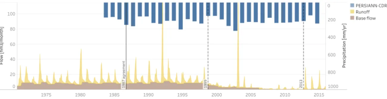
In situ measurements of the Yarmouk River flow at the Wahda dam (major dam built on the Yarmouk River) or Maqarin station before the dam’s construction, and Adasiya (outlet of the YRB by conven-tion; see Fig. 2.1) are the only ground data available in the basin. For years following the 1960s, three stages can clearly be noticed in the monitoring data from the Jordanian Ministry of Water and Irrigation/Jordan Valley Authority (MWI/JVA) that are presented in Fig.2.2: (i) a stationary regime before 1999; (ii) a sharp decrease of both the base flow and the runoff during the period 1999–2012; and (iii) the return of the runoff from 2013, when many Syrian refugees fled the civil war (Müller
et al.,2016). Quantitatively, the historical annual flow of the Yarmouk River is estimated to have been
in the range 450–500 hm3/yr (million cubic meter per year;Burdon,1954;Salameh and Bannayan,
1993;Hof,1998;UN-ESCWA and BGR,2013), and characterizes the pre-development stage. Over
the past, the discharge of the river has decreased by more than 85% to reach 60 hm3/yr in 2010. With
the civil war in Syria, the flow rose to an average of 120 hm3/yr for the period 2013–2015. Therefore,
as most springs and wadis feeding the Yarmouk are located in Syria and the Israel-controlled Golan Heights, Jordan is generally considered as the downstream riparian country suffering the most from
3 4 5 0 0 0 0 N 3 5 0 0 0 0 0 N 3 5 5 0 0 0 0 N 3 6 0 0 0 0 0 N 3 6 5 0 0 0 0 N 3 7 0 0 0 0 0 N 700 000 E 700000 E 750 000 E 750000 E 800 000 E 800000 E 850 000 E 850000 E Country/territory borders Jordan River basin Yarmouk River basin Inland sea Jordan River Ungauged reservoir Reference reservoir Landsat scene frame Legend 20 0 20 40 km SYRIA JORDAN Dead Sea LEBANON WEST BANK ISRAEL Lake Tiberias 173/37 174/38 174/37 3 4 5 0 0 0 0 N 3 5 0 0 0 0 0 N 3 5 5 0 0 0 0 N 3 6 0 0 0 0 0 N 3 6 5 0 0 0 0 N 3 7 0 0 0 0 0 N
Figure 2.1: The Yarmouk River basin as part of the Jordan River basin, with reservoirs detected using remote sensing (Sect.3.3.1; seeAvisse et al.,2017). Because in situ measurements are accessible for those managed by Jordan, they have been used to validate the method. All coordinates are expressed in the Coordinate Reference System (CRS) WGS 84/UTM zone 36N (EPSG:32636), in which 1 unit equals 1 m.
the river decline.
There are various theories related to the collapse of the Yarmouk flows. Most consider that it was caused by large droughts, increased diversions from the Yarmouk tributaries and groundwater abstrac-tions (UN-ESCWA and BGR,2013). According toSalameh and Bannayan(1993), rainfall dropped by 30% in the second half of the 20th century, andBeaumont(1997) estimates a natural runoff for the period 1968–1987 inferior by 25% to the one given bySalameh and Bannayan(1993) for the period 1927–1954. According to Kelley et al.(2015), the trend also continued after 1990 with the occur-rence of three of the four most severe multi-year droughts in the region in 25 years since 1901. Other analyses overlook climate change aspects and rather consider that the Yarmouk depleted because of excessive water abstractions and uncoordinated construction of dams in the Syrian part of the YRB
1975 1980 1985 1990 1995 2000 2005 2010 2015 0 20 40 60 80 100 Fl ow [h m 3/ m on th ] 0 200 400 600 800 1000 Pr ec ip it at io n [m m /y r] 19 87 a gr ee m en t 19 99 20 13 19 87 a gr ee m en t 19 99 20 13 PERSIANN-CDR Runoff Base flow
Figure 2.2: Yarmouk River flow – expressed in terms of base flow (moving minimum) and runoff – measured at the station of the Wahda dam by the Jordanian Ministry of Water and Irrigation, and the Jordan Valley Authority; and PERSIANN-CDR precipitation upstream from that station.
(FAO, 2009;Yorke,2016). It must be stressed that these potential explanations actually reflect the
perspectives of the two main riparian countries: Jordan considers that Syria violated their1987 bilat-eral agreement by building more dams than what was agreed on, while Syria blames climate change (Hussein,2017).
2.2 Bilateral agreements
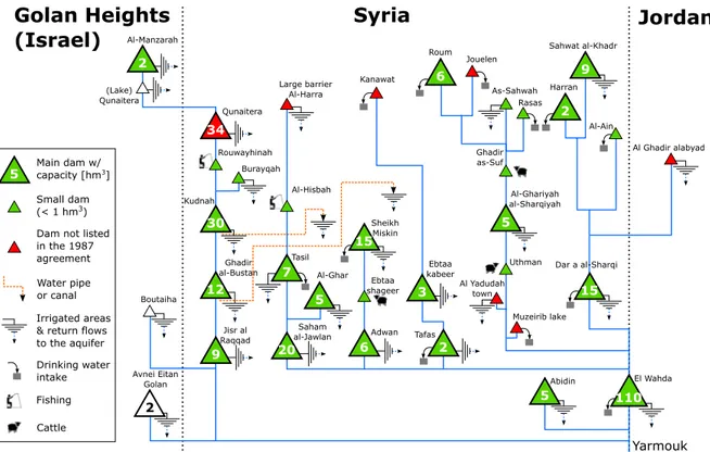
A first bilateral agreement was signed in 1953 between Jordan and Syria (Syria and Jordan,1953), and updated in 1987 (Syria and Jordan,1987) essentially to recognize water uses and dams already built in Syria (Rosenberg,2006;Hussein,2017). The 1987 version gave the right to Syria to retain water in 28 dams on the Yarmouk basin for a cumulated capacity of 164.64 hm3, and to access water welling
up above the 250 m level above the Wahda dam (less than 0.3% of the YRB area;Rosenberg,2006), or below the 200 m level below the site of the dam. Jordan got the right to use this reservoir’s water to irrigate crops in the Jordan Valley along the King Abdullah Canal (KAC; see Fig.2.1) essentially, and to supply Amman in freshwater. No explicit limitation regarding groundwater withdrawals is mentioned in the document. Consequently, after considering surface water flow depletions caused by the Syrian reservoirs listed in the1987agreement, reduced groundwater triggered by irrigation from springs and projected wells, and irrigation return flows, MWI/JVA(2002) expected inflows to the Wahda dam to attain 117.6 hm3/yr.
Yet, the flow monitored by MWI/JVA has never reached such a level before the civil war. Wahda has held at most 20 hm3(i.e. 18% of its 110 hm3capacity) between 2006, when it became operational, and
the beginning of the refugees migration in 2013. Consequently, the Yarmouk depletion has affected Jordan’s capacity to comply with the Treaty of Peace signed later with Israel (Israel and Jordan,1994). As per the two water rights on the Yarmouk described in the Israel–Jordan treaty, the hydrological risk is borne by Jordan: no matter the quantity reaching Wahda, (i) Israel has the right to a 25 hm3annual
allocation when Jordan gets the rest of the flow; and (ii) Jordan has the possibility to store up to 20 hm3
each year in Lake Tiberias during the Winter Period, and get it back at the entrance of the KAC in the Summer Period (concession). Technically, the sharing of water is operated at Adasiya: the flow is
Lake Tiberias ISRAEL SYRIA JORDAN Yarmouk River α β Adasiya KAC Jordan River Mukheibeh wells From Wff5 UntilWff 4 (&1 + (W1 (31
(&1: allocation = for Israel (W1: concession = for Jordan
(31: uncontrolled t losses = to the Jordan River (W1
Wahda dam
Figure 2.3: Diversion systems downstream from Adasiya.
separated between “alpha”, the diversion to the KAC, and “beta”, the natural route (Fig.2.3).
2.3 Agricultural development policies in Syria
As mentioned above, the role of Syria in the Yarmouk decline is still controversial, but not the fact that irrigation increased in its part of the basin since the pre-development stage. Before the 1960s, the Yarmouk and upstream wadis waters were primarily exploited for subsistence agriculture (Courcier
et al., 2005), but it changed with the first agrarian reform in 1958 and further highly centralized
economic policies towards the development of agriculture (Ababsa, 2013; Ibrahim et al., 2014) at the expense of water resources sustainability (Barnes,2009). In 1997, irrigation accounted for more than 80% of water use in the Syrian part of the YRB (World Bank,2001). Aw-Hassan et al.(2014) distinguish three phases in the development of this usage in Syria. In the first one, between 1966 and 1984, irrigation systems expanded. The country started building numerous dams and canals on the Yarmouk tributaries in the upper part of the YRB to increase surface water availability. However, these investments were not sufficient to enable the agricultural production to meet the ever-growing population needs. In the middle of the 1980s, Syria still had to import a large share of basic food supplies (Ababsa,2013). In the second phase (1985–2000), irrigated crops area kept expanding with the Government’s objective to increase food security and ensure self-sufficiency (Salman and Mualla,
2008). Some crops were guaranteed fixed price, and important subsidies for agricultural inputs such as seeds and fertilizers were given to farmers involved in governmental production schemes (Salman and
Mualla,2008;Ababsa,2013;Aw-Hassan et al., 2014;Ibrahim et al., 2014). Groundwater-irrigated
Yasser,2004) – as farmers could get low interest loans, well licenses were more easily delivered and fuel was strongly subsidized (Gül et al.,2005). But some of these incentives also fostered the growth of illegal groundwater pumping: 50% of wells were unlicensed at the end of the century (World Bank,
2001; Salman and Mualla, 2008). By any means, we can see in Fig. 2.2 that the decrease of the
Yarmouk River flow started at the end of this period. The third and last phase defined byAw-Hassan
et al.(2014), from 2001 to 2010, can then be described as a challenging management period for Syria.
The Government tried to address groundwater depletion while liberalizing the economy to stimulate investments in the agricultural sector (Ababsa, 2010; Kelley et al., 2015) and ensure food security. As a result, the decrease in the water table level could only be tempered. To these development stages followed the civil war in March 2011, which is still ongoing. This conflict and the 2013 Syrian refugees migration led to a strong reduction in irrigated land area, number of operational wells and reservoir storage in the Syrian part of the YRB (Müller et al.,2016).
2.4 Challenges to quantitatively analyze the basin
While all the above-mentioned studies provide useful information to understand the Yarmouk River flow variations since the end of the pre-development stage, they remain qualitative and basin-wide. Local, quantitative analyses are difficult because of the lack of available data going back as far as 1983 and the ongoing Syrian civil war. To our knowledge, the study conducted byAl-Bakri(2015) on the Jordanian part of the YRB is indeed the only analysis that provides local information on land use and water withdrawals. However, detailed information such as reservoir storage, canal diversions, ground-water withdrawals, crops and irrigation activity is crucial to identify with precision the causes of the Yarmouk River flow decline, and to distinguish consistent study results from widespread politically biased narratives.
Chapter 3
Methodology
This chapter introduces a modeling framework for quantitatively analyzing past changes and future scenarios in transboundary river basins. The approach relies on two components: (i) the development of remote sensing-based analysis tools to access information on infrastructures, and on both hydro-logical and anthropogenic parameters; and (ii) the implementation of a MAS system to adequately represent different human and institutional behaviors, and characterize various levels of interactions. Through the combination of these two techniques, one can get a somehow realistic representation of complex water resources systems in non-cooperatively managed river systems.
The chapter starts with a general description of the remote sensing techniques and MAS tools. Sec.3.3
then provides a more detailed description of the methodology to retrieve the above-listed data from remote sensing products in the Yarmouk basin.
3.1 Remote sensing
Remote sensing is used to retrieve hydrological and anthropogenic data without any detailed on-the-ground measurement, observation, survey, or interaction with water resources managers. Various techniques are applied to get precipitation, to build the multi-reservoir system, to estimate the incre-mental natural inflows to each reservoir, and to assess water withdrawals.
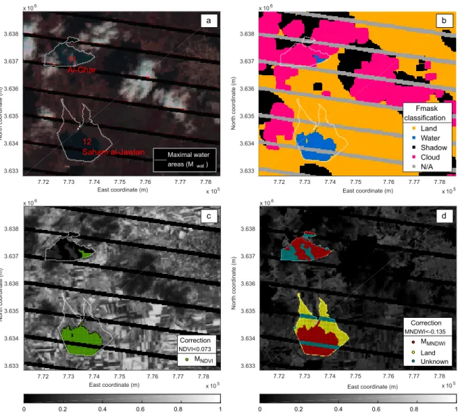
Precipitation Many remote sensing precipitation datasets exist with different coverage and resolu-tion. The monthly PERSIANN-CDR (Precipitation Estimation from Remotely Sensed Infor-mation using Artificial Neural Networks - Climate Data Records) product is used in this study. This global dataset covers the period from January 1983 onwards with a 0.25° spatial resolution. Dams A method is implemented to locate reservoirs, to assess their maximal storage capacities, and to monitor their storage from 1998 onwards for further validation of the model. It relies on Landsat satellite images for water area estimation, and digital elevation models (DEMs) for topography. Unlike existing approaches, the method does not require any in situ measurement
Landsat satellite images
(i). 2-D dynamic classification & water
bodies area retrieval
(ii). Statistical correction of elevation (iii). 3-D reconstruction through hidden areas
Digital elevation models
Final water surface area estimate
Reservoir elevation & storage estimates
Figure 3.1: Flowchart of the reservoir storage monitoring procedure (Avisse et al.,2017). and is appropriate for monitoring small, and often undocumented, irrigation reservoirs. The procedure works in three stages that are presented in the flowchart in Fig.3.1. The idea behind the process is (i) to use Landsat bands to enhance the detection of water pixels, then (ii) to exploit this information to statistically correct the DEM vertical errors and characterize reservoir bathymetry, and (iii) to use the updated topography to reconstruct missing parts of Landsat images (e.g. pixels covered by clouds or not captured by the Landsat sensor).
Incremental natural inflows to each reservoir The rainfall–runoff hydrological model GR2M de-veloped byMouelhi et al.(2006) is chosen, because of its simple formulation, to estimate the natural flow at the outlet of the basin. This lump model relies on two parameters only – pre-cipitation (see above) and evapotranspiration ETP (see below) – to produce a discharge on a monthly basis. The resulting flow is then separated between base flow and runoff. The runoff is disaggregated at each reservoir’s location using a modified drainage area ratio, and the base flow is assimilated to the groundwater flow.
Rivers, pipes and canals Connections between reservoirs are obtained using DigitalGlobe and CNES/Airbus high resolution (∼1 m) imagery available via Google Earth and elevation from a DEM.
Water withdrawals Irrigation water demand is calculated from remotely sensed land use maps, crop water requirements (Allen et al.,1998), precipitation (see above) and standard irrigation effi-ciencies.
All this data (except storage variations that are used for validating the results; see Sect.4.2) serves as input for the MAS model that is described below. It is then retrieved on a monthly basis from 1983 onwards (period covered by PERSIANN-CDR data).
3.2 Multi-agent simulation
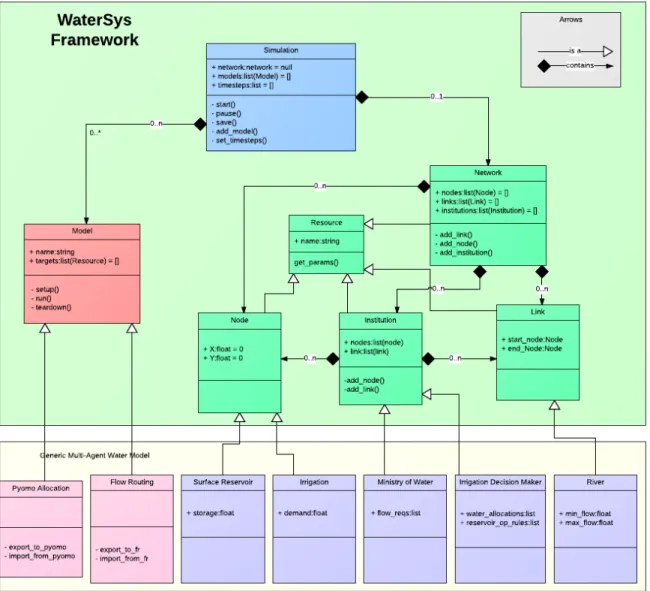
The PyNSim architecture (written in the object-oriented programing language Python; Knox, 2014, see Fig.3.2) has been chosen for developing the entire Jordan Water Project MAS model (Sect.0.1), and thus for developing the related transboundary MAS model for this Ph.D. research.
PyNSim is composed of three classes: Component, Simulator, and Engine (i.e. Model). The Com-ponent class (in green in the UML of Fig.3.2) further includes the classes Nodes, Links, Institutions, which can form Networks; the Engine class (in red in the UML) includes models that are designed to solve specific problems; and the Simulator class (in blue in the UML) is eventually defined for undertaking simulations through the individual Engines for a range of time-steps. Unique agents can further be defined from these classes.
Figure 3.2: Unified modeling language (UML) diagram of PyNSim (Knox,2014). The generic PyN-Sim framework is presented in the upper part (“WaterSys” refers to the previous denomination of PyNSim, but the UML remains unchanged), and the bottom part illustrates its application to the JWP.
Setup Institutions Setup Nodes Setup Links Network Setup Self
Run() Run() Run()
Engines
Run()
Engine 1 Engine 2 Engine 3 Engine 4
For each time step:
simulation.start() Step 1
Step 2
Figure 3.3: PyNSim simulation workflow. At each time-step, each resource in the network goes through a setup phase allowing it to make decisions independently. Then each engine runs, performing actions over the network as a whole (Knox,2014).
For water resources systems, PyNSim then adopts an arc and node configuration, which is particularly useful for representing the spatially distributed organization of agents inside the same system (Harou
et al.,2009, see also Sect. 1.4.2). The main asset of PyNSim, though, lies in the capacity to define
different levels of agents, from individual actors who manage one site to institutions who supervise interactions within the water resources system. All these agents are integrated in a single computing framework where human and institutional decisions complement the physical processes. When a simulation is launched, the Engines are sequentially run to reach their own objectives. All agents then store and update parameters that can be either inherent to their classes, or defined by the user of the model (e.g. a capacity, storage or inflow for a reservoir agent; see the simulation workflow in Fig.3.3). Except for the JWP modeling application, PyNSim has for instance been used to determine the optimal placement of new power plants within a network (Knox et al., 2016). It must be stressed that the PyNSim code has been developed recently, which explains why applications are for now limited.
3.3 Application to the Yarmouk River basin
Information on the inaccessible part of the YRB (i.e. Syria and the occupied Golan Heights) is re-trieved using the remote sensing techniques introduced in Sect.3.1above and detailed in the following. The first subsection below describes the storage monitoring technique, which is used for both

![[PDF] Les feuilles de style cours complet avec exemples de pratique - Cours informatique](data:image/gif;base64,R0lGODlhAQABAIAAAP///wAAACH5BAEAAAAALAAAAAABAAEAAAICRAEAOw==)