Pingos, palsas and lithalsas:
comparison with the Martian mounds
Albert Pissart
Professeur émérite à l’Université de Liège, 29, rue Lavaux, 4130 Esneux (Belgium). E-Mail: [email protected]
KEYWORDS: Mars, pingos, lithalses, Canadian Arctic, Hautes-Fagnes. ABSTRACT
On Mars, mounds similar to pingos were described for a long time. From the Canadian Arctic, some rare pingos which are neither of the Greenland type, nor of the Mackenzie type may be equivalent of some features on Mars. On the other hand, remnants of lithalsas looks very similar to “ring shaped features” described by de Pablo & Komatsu (2009) in the Utopia Basin.
1. Introduction
The similarities between Martian mounds and pingos on Earth are so great that as soon as the first Viking images became available, it was proposed that pingos are present on Mars (see Rossbacher & Judson 1981). Now the periglacial origin of mounds on some parts of Mars seems largely accepted (de Pablo & Komatsu 2009, Burr et al. 2009). They have been compared extensively to periglacial mounds in the Arctic, starting more than 25 years ago (Lucchita 1981, Greeley 1985, Joens 1985, Witbeck & Underwood 1985). Recognizing periglacial mounds from satellite images is, however, a delicate matter. It is especially difficult on Mars images as we generally do not know the nature and structure of the substrate near the surface of this planet (de Pablo & Komatsu 2009).
In the present paper, I review in greater detail the properties of diverse periglacial mounds on Earth including lithalsas as recently discussed by Burr et al. (2009). I also describe a type of mounds that to our knowledge has not been mentioned so far: the pingos of the summit of Prince Patrick Island that are probably the best candidate for comparison with some Martian mounds formed in bedrock.
2. Pingos
Two kinds of pingos are known on Earth, as described in periglacial geomorphology textbooks (e. g. Washburn 1979, Ballantyne & Harris 1994, French 1996, 2007).
2.1. OPEN-SYSTEM PINGOS
Open-system pingos (also called East Greenland pingos) appear at the base of slopes where ground water moves by gravity generally under, or sometimes inside, the permafrost generating artesian pressure. These types of pingos require significant relief, an unfrozen permeable substrate, and enough alimentation in water (precipitations?).
Open-system pingos can be large. In Alaska, based on a study of 270 such pingos, Holmes et al. (1968) reported that the maximum diameter and height were 500 m and 35 m. In the Yukon, the maximum diameter and height of the 472 pingos described by Hughes (1969) were 330 m and 25 m. Müller (1959) described a 30 m high pingo in Greenland. In Spitzbergen, Ahman (1973) reported a 42 m high mound and Liestol (1975), who located 69 pingos, mentioned one with a large base, 825 m in length and 275 m in width. Open-system pingos are usually round or elliptical in plan view, but their morphology can be complex. Pingos clusters also occur, possibly due to the displacement of the exit point of the water through the surface material.
This kind of pingo usually domes up soft sediments ranging from gravels to clay. However, in Spitzbergen and Greenland, they lift bedrock including sandstones (Müller 1959) and schists (Balkwill et al. 1974). Müller (1959) and Holmes et al. (1968) calculated that artesian water pressure forming open-system pingos is not sufficient to raise the sediments; they concluded
that cryostatic pressure (generated by the volumetric expansion in the water-to-ice phase transition) probably combines with artesian pressure to raise the mounds. On Mars, as gravity is lower than on Earth, artesian water pressure is correspondingly smaller for the same difference in altitude but this effect tends to be offset by the water pressure required to rise the pingo also being smaller.
2.2. CLOSED-SYSTEM PINGOS
2.2.1. THE MACKENZIE TYPE
More than 1,300 pingos occur in the Mackenzie Delta. Their morphology and distribution were studied from aerial photos by Stager (1956) who gives the following statistics (fig. 1):
“Minimum average distance between pingos in miles per 10 square miles”: 0.3 miles (0.5 km) “Height”: 49% less than 10 m, 41% between 10 and 27 m, 10% more than 27m. “Vertical shape”: Plug like, relatively steep slope 81%, swelling shaped 16%, swelling and plug 3%.
“Planar outline”: round 71%, oval 20%, irregular outline 9%. “Summit character”: smooth 76%, ruptured 16%, collapsed 8%. “Location”: in present or former lake basins 98%, not in lake basin 2%.
Fig. 1. Size, shape outline and summit morphology of the closed-system pingos of the Mackenzie delta from Stager (1956, fig. 1). Regarding the size classes: small means less than 10 m in height; medium between 10 and 27 m; large more than 27 m. This classification is relative and has been determined without precise measurement.
The genesis of these pingos is well established and described in the numerous excellent papers of Mackay. His observations over more than 20 years of study are conveniently summarised in his 1998 paper.
These pingos are located above unfrozen domains within the permafrost, so-called taliks that exist in the high Arctic under deep lakes or rivers. Taliks often comprise coarse permeable material (gravel, sands) saturated in water. Once the lakes are drained or the rivers have shifted courses due to lateral erosion, the taliks begin to freeze. As the freezing front propagates downward from the top of the talik and joins the steep sides of the talik, a closed system develops in which water is pressurized by the progressive increase in the H2O volume as
freezing continues. Water from the pressurized talik can be injected towards the surface where it can suddenly appear as a geyser, or more commonly, the water is injected below the pingo itself and forms a water lens that domes up the pingo. This water will later freeze to become what is called “injection ice”. The injections are localized under the pingo because it is the path of least resistance; upheaving of the pingos occurs more readily than the deformation of frozen sediments elsewhere.
The majority of the lakes in the Mackenzie delta have only one pingo; lakes with two or more pingos are rare. Accordingly, the spatial density of closed-system pingos is always low. The maximum density reported by Stager (1956) was 31 pingos per 10 square miles (1.2 pingos per km2) corresponding to a mean spacing of 1.7 km; the density is generally lower than 0.4 pingos
by km2.
Closed-system pingos usually form in sands and gravels. But at least one was described in Palaeozoic dolomite bedrock with numerous fractures and joints that made it permeable (St Onge & Pissart 1990). This mound (22 m high, 60 m in diameter, ~ 75,000 m3; fig. 2) shows that
fractured bedrock may contain enough water that can migrate and freeze to form pingos.
Fig. 2. 22 m-high, closed-system pingo in Palaeozoic dolomite that is pervasively fractured in the N-W territories (68° 27′ 34″ N; 117° 02′ 39″ W), District of Mackenzie, 70 km S-W of Dolphin and Union Strait (St Onge & Pissart 1990).
The thickness of the upheaved sediments or rocks on the pingos slopes is unknown and likely varies from one pingo to another. It must be thicker than the active layer to prevent melting at the end of summer. The 14.30 m-thick debris mantling Ibyuk pingo (Mackay 1986), one of the biggest of the Mackenzie Delta with its 49 m in elevation, seems to be the thickest cover that has been reported.
Almost all the pingos that are known in the Queen Elisabeth Island were near the seacoast and are in relation with changes of the sea level (see their location on the map of Washburn 1979, fig. 5.53, p. 189).
2.2.2. THE PRINCE PATRICK ISLAND TYPE
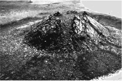
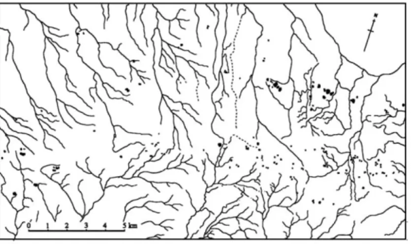
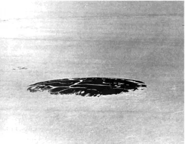
A distinct type of pingos occurs on the summit of Prince Patrick Island (Canada, 76° 25′ N, 120° 07′ W) (Pissart 1967). A group of 130 pingos located in two linear trends near the summit of the island (fig. 3) in a region of deep permafrost. Their spatial density, 2.2 pingos per square kilometre (in the west part of the figure), exceeds that of the Mackenzie Delta. In contrast with open-system pingos, they do not occur at the base of hill slopes or near former lakes or rivers. They form in sands and gravels of the Beaufort Formation, which overlies Palaeozoic bedrock. The maximum height of 70 of these pingos is 13 m (mean 3.30 m) and larger diameter is 250 m (mean 59 m). The smallest mounds have a swelling shape (following the catalogue given by Stager on our figure 1) and sometimes a swelling and plug shape. A plug shape is frequent for the medium-sized mounds. The morphology of the highest mounds is usually complicated with a lot of irregular small mounds as shown on figure 5. That morphology is not clear but a sketch of crater is perceptible. Some irregular forms result clearly from the joining of two, three or four circular forms of different sizes, similar to clusters of open-system pingos. All of these pingos are covered, much like the surrounding terrain, by polygonal patterned ground (fig. 4 and 5).
Fig. 3. The two linear series of pingos on the summit of Prince Patrick Island (Pissart 1967).
I postulate that unfrozen pockets of saturated sands became isolated in the growing permafrost when deep permafrost developed after the retreat of the last ice sheet. These seem aligned with known faults in the area. It seems likely that these pockets were pressurized by the progressive freezing of water and that water was injected to the surface to release this pressure preferentially through the brecciated or fractured bedrock along the faults.
Fig. 4. A 2 m-high pingo near the summit of Prince Patrick Island with its polygonal pattern ground underlined by the snow in the troughs between polygons (Pissart 1967).
Fig. 5. A large pingo on the summit of Prince Patrick Island with its irregular shape and the ice wedge polygons. Height 11 m, diameter 210 m (Pissart 1967).
In 1967, the Prince Patrick pingos did not show any sign of growth or decay presumably because they formed long ago and are stable due to the very cold climate. The mean annual temperature is −17.7°C. The mean monthly temperature exceeds 0°C during only two months of a year. Annual precipitation averages 95.1 mm per year. (1962–1990 data from http://www.climate-charts.com).
Similar pingos were described by Hodgson (1982) on the summit of Amund Ringness Island (600 km to the East, 78° 20′ N, 96° 20′ W); they are also aligned, over a distance of 1.5 km. They and the pingos of the summit of Prince Patrick Island may have formed in similar ways.
2.3. OTHER CHARACTERISTICS OF PINGOS
All pingos are formed by pressurized water. Water is injected under closed-system pingos and becomes injection ice as Mackay (1998) demonstrated unambiguously. Segregation ice may also
form, aided by the water pressure, but this kind of ice has not been reported for closed-system pingos.
Injected water forms lenses below the closed-system pingos that are thicker in the centre (Mackay 1998). Consequently, the young mounds usually are lens shape (swelling shape of Stager 1959, see our fig. 1) a few decimeters in height. Later, with subsequent injections, they grow progressively and become domes and eventually cones. According to Mackay pingos grow only vertically and not laterally. To our knowledge, in contrast with palsas and lithalsas, pingos never appear like pancakes with a very flat top and steep slopes on the sides.
Due to their growth, the frozen sediment cover of mature pingos may rupture forming cracks that tend to be radial near the pingo summit. These cracks expose the ice and initiate the demise of the pingo with the formation of a crater due to melting of the exposed ice. A small pond usually appears in this crater and accelerates the melting. Later through continued thermokarst development, the crater becomes so large that the pingo eventually disappears leaving a rampart around a depression. Although the internal structure of this kind of rampart has not been described, it most probably comprises mainly active layer material that moved off the slopes of the pingo and accumulated at its border. Part of this rampart probably also results from the tilting of the material during the growth of the pingo. Mackay (1998) has shown that the thickness of ice under the ramparts of degraded pingos is so large that “probably very little of the rampart would remain if it was complete degradation of permafrost surrounding and beneath the pingos.” If similar ramparts exist on Mars, much ice may also remain in the ramparts.
The growth of pingos due to injection of water may be interrupted by direct drainage to the surface, which may occur repeatedly. The raised pingo then collapses partially and a circular fracture may appear around its perimeter. Mackay (1977) who observed the phenomenon in the Mackenzie delta gave the name of “pulsating pingos” to these mounds. Similar circular fractures are visible not only in the Mackenzie Delta but also around open-system pingos (see for example the plate II of Müller 1959).
2.4. COMMENTS FOR COMPARISON OF TERRESTRIAL PINGOS WITH POTENTIAL
PINGOS ON MARS
Some Martian mounds with a diameter between 100 and 250 m described by de Pablo & Komatsu (2009, fig. 3b and 3f) show circular fractures surrounding pingos similar to those described by Mackay for pulsating pingos. These fractures suggest a similar process of recurrent inflation and deflation for these Martian mounds. Many mounds on Mars are far away from slopes making it unlikely that they are open-system pingos. The hypothesis that these mounds are closed system pingos is somewhat more viable as they share many similarities with the pingos described above that form in bedrock or on Prince Patrick Island. These unlike the more common closed system pingos in the high Arctic, are not associated with deep lakes or rivers and probably appeared during the present permafrost installation as it is shown on fig. 6.
Fig. 6. Sketch showing a possible genesis for the Pingos of the summit of Prince Patrick Island (Canada, 76° N).
3. Palsas and lithalsas
Palsas and lithalsas are quite different from pingos as they do not require pressurized water to form. Their icy core develops due to growth of lenses of segregation ice or of layers of ice formed in saturated peat (e. g. Seppälä & Kujala 2009). The growth of these ice lenses is fuelled by the flow of unfrozen water towards the freezing zone where it accumulates as segregation ice, an ubiquitous form of ice long recognized (e. g. Taber 1929, Beskow 1935).
3.1. PALSAS
The first patches of permafrost that appear on the way to the North are palsas, which grow in peatlands. With notable exceptions (e. g. Seppälä & Kujala 2009, Seppälä 2011), the ice of these mounds is almost entirely accumulated in silty material under the peat cover (Zoltaï & Tarnocaï 1971, Brown 1973, Evseev 1973, Ahman 1977, Allard et al. 1986). Peat is a very good thermal insulator when it is dry in the summer. In the winter, frozen ice-rich peat conducts heat more readily, leading to colder ground under a palsa than in surrounding terrain; small permafrost island can form where ground conditions are favorable in areas generally devoid of permafrost (see review by Pissart 2002). The thawing of a palsa does not leave a rampart remain. Very low ridges may reflect the former location but just for a short time. As peat is most unlikely on Mars, palsas are not expected there.
3.2. LITHALSAS
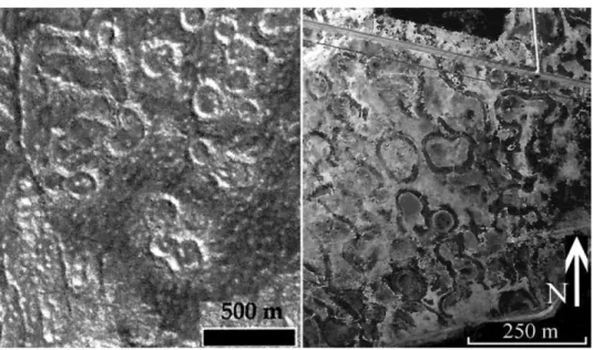
As shown by fig. 7, the morphology and size of lithalsas in the Hautes Fagnes Plateau are strikingly similar to some ring shaped features on Mars reported by de Pablo & Komatsu (2009, fig. 5c). The role of the snow cover is however considered in the formation of lithalsas. These kinds of mounds are the more often very flat and the mechanism of their formation is still in discussion (Pissart et al. 2011).
Fig. 7. On the left, these annular ridges on Mars (modified from fig. 5c of de Pablo and Komatsu (2009) closely resemble the remnants of lithalsas in the Hautes-Fagnes, Belgium shown on the right (Pissart 2000, 2003).
One interesting possibility is that the loose, fine-grained surface material visible from the Mars landers plays the same thermal insulating role as the insulating cover on lithalsas. Taking a specific example, a 1.15 m-thick insulating cover shielded the ice of the mound on a lithalsa described by Pissart et al. (1998) in the Yukon. From the surface downward, the cover consisted of 25 cm of calcareous humus; 30 cm of a white and very light (dry density: 590 kg m−3) soft
chalk fragments, and 60 cm of powdered chalk. Similar mounds with a fine-grained mineral cover, which would provide excellent thermal insulation at the low atmospheric pressure of Mars (B. Hallet; personal communication, 2010), may also exist on Mars.
4. Conclusion
Similarities between mounds on Mars and pingos on Earth are considerable; they include the shape, summit craters and occasional circular fractures around some mounds. Pingos probably exist on Mars. Being sometimes far from slopes, they are unlikely to be open-system pingos. On the other hand, it is difficult to interpret the mounds on Mars as closed-system pingos because no trace of lakes is visible and the spacing of these mounds is smaller than that of the typical pingos in the Mackenzie delta. Pingos that occur in deep permafrost near the crest of Prince Patrick Island or in pervasively fractured bedrock may constitute the most realistic known terrestrial analogues for some of the Martian mounds.
With their characteristic pancake shape, lithalsas resemble relatively flat mounds bordered by steep slopes on Mars. The striking similarity between annular ridges on Mars and the depressions surrounded by ramparts that are remnants of lithalsas in the Hautes-Fagnes (fig. 7) (Belgium) suggest a similar origin involving segregation ice growth in moist silty material followed by thawing. In closing, I note that pingos and lithalsas on Earth form under different
climatic conditions. If both of these types of mounds are present in the same place, on Mars they could reflect two generations of periglacial mounds and a significant change of climate between these generations.
Acknowledgements
Bernard Hallet suggested that I write this short paper and he gave me numerous valuable remarks and suggestions, both editorial and scientific. I thank him very much for his help and encouragements. I am also grateful to my friends Amand Lucas and Jean Grimberieux who improved my English text.
References
Ahman, R. (1973): Pingos in Adventdalen and Reindalen, Spitsbergen. – Svensk Geografisk Arsbok 49: 190–197.
Ahman, R. (1977): Palsar i Nordnorge (Summary: Palsas in Northern Norway). – Meddelanden fran Lunds Universitets Geografiska Institution 78, 156 p.
Allard, M., Seguin, M. K. & Lévesque, R. (1986): Palsas and mineral permafrost mounds in northern Québec. – In: Gardiner, V. (ed.): International Geomorphology. Part II. J. Wiley and Sons Ltd., 285–309. Balkwill, H. R., Roy, K. J., Hopkins, W. S. & Sliter, W.V. (1974): Glacial features and pingos, Amund Ringnes
Island, Arctic Archipelago. – Canadian Journal of Earth Sciences 11: 1319–1325.
Ballantyne, C. K. & Harris, C. (1994): The periglaciation of Great Britain. – Cambridge University Press, 330 p.
Beskow, G. (1935): Tjälbildningen och Tjällyftningen, Statems Väfinstitut. – Meddelande, 48, Sveriges Geologiska Undersökning, Sor. C., n° 375, Stockholm, 242 p.
Brown, R.J. E. (1973): Ground ice as an initiator of landforms in permafrost regions. – 3rd Guelph Symposium on Geomorphology. Research in polar and alpine Geomorphology, Proceedings Geobooks, Norwich, 25–42.
Burr, D. M., Tanaka, K. L. & Yoshikawa, K. (2009): Pingos on earth and Mars. Planetary and Space Science 57: 541–555.
de Pablo, M. A. & Komatsu, G. (2009): Possible pingo fields in the Utopia basin, Mars: geological and climatical implications. – Icarus 199: 49–54.
Evseev, V. P. (1973): Monticules de boursouflement de migration. – Proceedings, Second International Conference on Permafrost, Yakutsk, vol.2, 98–102.
French, H. M. (1996): The periglacial environment. – Second edition. Longman, 341 p. French, H. M. (2007): The periglacial environment. – Third edition. Longman, 458 p. Greeley, R. (1985): Planetary landscapes. – Allen and Unwin, London, 265 p.
Hodgson, D.A. (1982): Surficial materials and geomorphological processes, Western Sverdrup and adjacent islands, district of Franklin. – Geological Survey of Canada, Paper 81– 9, 42p.
Holmes, G. W., Hopkins, D. M. & Foster, H. (1968): Pingos in central Alaska. – Geological Survey Bulletin, 1241-H, Washington: H1–H40.
Hughes, O. L. (1969): Distribution of open system pingos in central Yukon territory with respect to glacial limits. – Geological Survey of Canada, paper 69–34, 8 p.
Joens, H. P. (1985): Permafrost features on earth and Mars: Similarities, difference. – In: Terrestrial planets: compared planetology, 11. Luna and Planetary Institute, 22–91.
Liestol, O. (1975): Pingos, springs and permafrost in Spitzbergen. – Norsk polarinstiyutt Arsbok 7–29. Lucchita, B. K. (1981): Mars and Earth: Comparison of cold-climate features. – Icarus 45: 264–303.
Mackay, J. R. (1977): Pulsating pingo, Tuktoyaktuk peninsula, NWT. – Canadian Journal of Earth Sciences 14: 209–222.
Mackay, J. R. (1986): Growth of Ibyuk Pingo, Western Arctic Coast, Canada and some Implications for Environmental Reconstructions. – Quaternary Research 26(1): 68–80.
Mackay, J. R. (1998): Pingo growth and collapse, Tuktoyaktuk peninsula area, Western Arctic Coast, Canada: a long-term field study. – Geographie Physique et Quaternaire 52(3): 271–323.
Müller, F. (1959): Beobachtungen über Pingos. Detailuntersuchungen in Ostgrönland und in der kanadischen Arktis. Meddelelser om Gronland 153(3), 127 p. Technical translation 1073 prepared in 1963 for the division of Building Research, National Research Council of Canada under the title “Observations on pingos”.
Pissart, A. (1967): Les pingos de l’île Prince Patrick (76° N– 120° W). – Geographical Bulletin 9 (3), 189– 217. Technical translation 1401, made in 1970 by William Barr for the Division of Building Research, National Research Council of Canada, under the title “The pingos of Prince Patrick Island (76°N– 120°W)”.
Pissart, A. (2011): The potential lateral growth of lithalsas. – Quaternary Research 75: 371– 377.
Pissart, A. (2000): The remnants of lithalsas of the Hautes Fagnes (Belgium): a summary of present day knowledge. – Permafrost and Periglacial Processes 11(4): 327–355.
Pissart, A. (2002): Palsas, lithalsas and remnants of these periglacial mounds. A progress report. – Progress in Physical Geography 26(4): 605–621.
Pissart, A. (2003): The remnants of Younger Dryas lithalsas on the Hautes Fagnes Plateau in Belgium and elsewhere in the world. – Geomorphology 52: 5–38.
Pissart, A., Harris, S., Prick, A. & Van Vliet-Lanoë, B. (1998): La signification paléoclimatique des lithalses (palses minérales). – Biuletyn Peryglacjalny 37: 141–154.
Rossbacher, L. S. & Judson, S. (1981): Ground ice on Mars: Inventory, distribution and resulting landforms. – Icarus 45: 39–59.
Seppälä, M. & Kujala, K. (2009): The role of buoyancy in palsa formation. – In: Knight, J. & Harrison, S. (eds.): Periglacial and Paraglacial Processes and Environments. The Geological Society, London, Special Publications 320: 51–56.
St Onge, D. & Pissart, A. (1990): Un pingo en système fermé dans les dolomies paléozoïques de l’Arctique canadien. – Permafrost and Periglacial Processes 1: 275–282.
Stager, J. K. (1956): Progress report on the analysis of the characteristics and distribution of pingos east of the Mackenzie Delta. – Canadian Geographer 7: 13–20.
Washburn, A. L. (1979): Geocryology. A survey of periglacial processes and environments. – London, Edward Arnold, 406 p.
Witbeck, N. E. & Underwood, J. R. (1985): Enigmatic hills of the mottled plains, Mare Acidalium quadrangle (MC-4), Mars. – In: Reports of Planetary Geology and Geophysics Program, 1984, NASA, Washington, DC, 358–360.
Zoltaï, S. C. & Tarnocaï, C. (1971): Properties of a wooded palsa in northern Manitoba. – Arctic and Alpine Research, 3(2): 115–129.