HAL Id: hal-01081861
https://hal-mines-paristech.archives-ouvertes.fr/hal-01081861
Submitted on 1 Dec 2014
HAL is a multi-disciplinary open access
archive for the deposit and dissemination of
sci-entific research documents, whether they are
pub-lished or not. The documents may come from
teaching and research institutions in France or
abroad, or from public or private research centers.
L’archive ouverte pluridisciplinaire HAL, est
destinée au dépôt et à la diffusion de documents
scientifiques de niveau recherche, publiés ou non,
émanant des établissements d’enseignement et de
recherche français ou étrangers, des laboratoires
publics ou privés.
M Abzalov, S Drobov, O Gorbatenko, A Vershkov, Olivier Bertoli, Didier
Renard, Hélène Beucher
To cite this version:
M Abzalov, S Drobov, O Gorbatenko, A Vershkov, Olivier Bertoli, et al.. Resource estimation of
in situ leach uranium projects. Applied Earth Science, Maney Publishing, 2014, 123 (2), pp.71-85.
�10.1179/1743275814Y.0000000055�. �hal-01081861�
projects
M. Z. Abzalov*
1, S. R. Drobov
2, O. Gorbatenko
3, A. F. Vershkov
2, O. Bertoli
4,
D. Renard
5and H. Beucher
5Sandstone-type uranium deposits contain approximately 28% of the world uranium resources. Many of
these deposits are located below the water table in weakly lithified or non-consolidated sands, and
therefore they can be exploited using in situ leach (ISL) technology. Such technology is based on
dissolving uranium minerals directly in their host rocks (in situ) by reactive solutions that are injected
through drill holes and then pumping the dissolved solution to the surface through some discharge drill
holes. Uranium grade is determined by down-hole geophysics, in particular the prompt fission
neutrons, or PFN, technique, coupled with sampling and assaying of the drill core. The drill grid which
is used in Kazakhstan for definition of ISL uranium resources are as follows: (i) Measured: average
506100 m (range from 25650 to 506100 m); (ii) Indicated: average 506200 m (range from
506100 to 506200 m); and (iii) Inferred: average 506400 m (range from 506400 to 1006800 m).
Estimation and reporting of uranium resources for ISL projects differ from hard rock mining projects in
the need for quantitative estimation of the geotechnical and hydrogeological parameters which are
specific for ISL technologies. The main parameters which need to be considered are as follows: (i)
grade and geometry of mineralisation are estimated with accuracy sufficient for supporting the remote
mining; (ii) if grade is estimated using the gamma logging technique secular disequilibrium should be
studied and reported; (iii) hydrogeological confinement of the mineralised horizon; (iv) permeability of
the mineralised horizon; (v) composition of the host rocks, in particular the carbonate content, in order
to estimate if uranium mineralisation is amenable to dissolution by acid or alkaline solutions; (vi)
groundwater flow; (vii) aquifer salinity; and (viii) rate of the in-situ dissolution of the uranium minerals.
Hydrogeological and geotechnical information is obtained by testing the drill core samples and in the
field, using the pump tests and the down-hole piezometers. Modifying factors for conversion resources
to reserves are verified and corrected using field leach tests of uranium. This test is a strict requirement
for feasibility studies of the ISL uranium projects in Kazakhstan.
Keywords: Uranium, ISL, Sandstone type, Mineral resources, Evaluation
This paper is part of a special issue on Mineral Resource Estimation
Introduction
Uranium deposits are formed in many different geolo-gical environments, including surficial uranium accumu-lations, different magmatic settings, volcanic edifices,
altered metamorphic rocks, sedimentary rocks and various hydrothermal setting in both high and low temperature (Dahlkamp, 1993). Because of their geolo-gical diversity, there is no single procedure to define resources for this group of deposits; therefore, the current paper is focused on sandstone type of uranium (Fig. 1a). Globally, this is most abundant type of uranium deposits containing approximately 28% of the world uranium resources (Abzalov, 2012); however, the mining of these deposits is very challenging because of the difficult geotechnical conditions caused by the presence of aquifers in the poorly consolidated sands that host these deposits.
In order to overcome the technical challenges caused by the geotechnical conditions, a new exploitation technology was developed in 1960s, known as in situ leach (ISL). In situ leach technology is based on 1Centre of Exploration Targeting, University of Western Australia, and
MASSA Geoservices 8 Burnettia Lane, Mount Claremont, WA 6010, Australia
2VOLKOVGEOLOGIIA, Uranium Exploration Company, Almaty,
Kazakhstan
3Mining and Chemical Department, National Atomic Company
Kazatomprom, Astana, Kazakhstan
4Geovariances, Avon, Cedex, 77212, France
5Centre of Geostatistics, Mines-Paris Ttech, Fontainebleau, Cedex,
France
dissolving uranium minerals directly in their host rocks (in situ) by reactive solutions injected through drill holes. Solutions dissolve the uranium and are then pumped to the surface through discharge drill holes (Bush, 2000; IAEA, 2001; McKay et al., 2007). On the surface the solutions are collected and supplied to the processing plant for extraction of uranium. The technology requires high permeability of the host rocks, which favours exploitation of the sandstone-type uranium deposits by ISL techniques.
In comparisons with conventional mining, ISL technology has certain advantages. It allows access to a lower grade deposits than conventional mining techniques, and permits exploitation of uranium ore bodies hosted in weakly lithified sands at depth up to 700 m (Abzalov, 2012). However, evaluation of the technical feasibility of the ISL uranium projects and assessment of their economic viability different com-pared to conventional hard rock mining projects. The most important of these are as follows:
(i) groundwater flow
(ii) permeability of the host rocks (iii) geometry of uranium mineralisation (iv) aquifer salinity
(v) contents of carbonate in the host rocks (vi) rate of the in-situ dissolution of the uranium
minerals
(vii) environmental impact of the groundwater resources
(viii) aquifer restoration requirements.
Special geological characteristics of the sandstone-type uranium deposits and their highly specific exploitation techniques based on ISL technology have led to the development of special procedures for resource estimation. Although reporting of ISL resources under the JORC Code has the same basic principles as that used for other mineral commodities (JORC, 2012), implementation of the JORC code principles to ISL uranium projects requires additional issues which are specific for these types of projects.
1 Map showing distribution of the sandstone-type uranium deposits and the studied basins: a main sandstone-type ura-nium deposits of the world; b Syrdarja and Shu-Sarysu basins in Kazakhstan (Abzalov, 2012); c Great Divide basin, Wyoming (Abzalov and Paulson, 2012); d Callabonna sub-basin, South Australia
The current paper describes resource estimation practices used at ISL uranium projects. It explains the drilling, sampling and logging requirements for the estimation of ISL uranium resources and shows the limitations of geophysical grade estimation techniques. The paper also overviews the geotechnical and hydro-geological characteristics of uranium mineralisation that need to be studied and reported as an integral part of the ISL project resource estimation. The main risks and possible approaches to mitigate these risks are also shown. The information included in the current review mainly was collected at ISL operations in Kazakhstan (Table 1), where ISL uranium production commenced in the 1970s (Fig. 1b). These data were coupled with observations made at the ISL sandstone-type uranium deposits amenable for exploitation by ISL technologies in the USA (Fig. 1c) and ISL operations in Australia (Fig. 1d).
Geological background of the ISL
projects
Sandstone-type uranium mineralisation is formed by low temperature hydrothermal solutions depositing uranium in permeable sedimentary strata. As a consequence of a given depositional environment, the mineralisation geo-metry is highly irregular. It commonly occurs as roll-shaped (rollfront) bodies (Fig. 2a), or, more complex bodies of irregular (Fig. 2b) to amoeba-like shapes (Fig. 2d). The vertical profile of the sandstone-type uranium deposits can be extremely complex; in particular, if the deposit includes several vertically stacked miner-alised zones (Fig. 2b). In plan view, minerminer-alised zones can form meandering ribbons up to several tens of kilometres long (Fig. 1b), or, can be represented by a swarm of discontinuous lenses (Fig. 1d). This is common for basal channel type deposits where uranium is distributed along braided palaeo-channels (Fig. 2c).
The main uranium minerals of the sandstone-type uranium deposits are pitchblende and coffinite (Abza-lov, 2012). These are relatively easily recovered from host rocks by sulphuric acid or alkaline leach.
Depending on their depositional environments and structural characteristics, the sandstone uranium deposits are subdivided into four main groups: roll-type, also known as rollfront; tabular; basal channel; and structurally controlled (Dahlkamp, 1993; IAEA, 2009; Abzalov, 2012). This current review mainly uses data collected in central Kazakhstan from roll-type mineralisation that coexists with tabular mineralisation (Petrov et al., 2008). The studied deposits include Inkai and Budenovskoe, both of which are located in the Shu-Sarysu basin (Fig. 1b). Rollfronts were additionally studied at the Akdala (Shu Sarysu basin) and Kharasan (Syrdaria basin) deposits in central Kazakhstan (Fig. 1b). Several roll-type deposits were studied in the Great Divide basin, Wyoming, USA (Fig. 1c). The review of the basal-channel type mineralisa-tion is based mainly on the deposits of the Collabonna sub-basin in Australia (Fig. 1d).
The studied deposits differ in their depositional envir-onments and structural characteristics, in particular their degree of spatial variability of the grade and geometry of the mineralised domains which is reflected in the different exploration grids applied for their resource estimation (Table 1). However, the methodology of estimation of
resources is similar within the studied group and so they are described together.
Resource definition drilling
Exploration for sandstone-type uranium deposits is entirely based on drilling and usually commences as a series of widely spaced drill fences distributed along a redox front with the drill fences oriented at a right angle to the front. The distance between drill traverses at this stage is several kilometres. The quality of drilling and recovery of representative samples is important from the early stage of the project and progressively increases as the project matures and approaches the resource estimation stage. In order to minimise core losses, triple-tube diamond drilling is routinely used. Shallow deposits can be drilled using Sonic methods which are success-fully used for exploration of the mineral sands deposits (Abzalov et al., 2011).
In Kazakhstan, the exploration traverses are distrib-uted at 6 to 12 km spacing. The distance between drill holes on the traverse is usually 200 m. When miner-alisation is encountered the drilling spacing is progres-sively reduced. Depending on mineralisation style, the final resource definition grid can be 100650 or 50620 m (Table 1). At the feasibility study stage, the drilling pattern is further infilled using mud rotary non-core drilling. In the Great Divide Basin, USA, a similarly staged drilling approach was used for estimation resources, although, some deposits in the region have been infilled to 30630 m (Abzalov and Paulson, 2012).
Resources of the sandstone-type uranium deposits in Australia (e.g. Beverly and Honeymoon) are estimated using drill holes distributed as a square grid with 25 to 30 m centres (McKay et al., 2007; Skidmore, 2007).
As an approximate guidance the following drilling grids, which are used in Kazakhstan for roll-type deposits, can be considered for preliminary estimation of the drilling budget:
(i) Measured: average 506100 m (range from 25650 to 506100 m)
(ii) Indicated: average 506200 m (range from 506100 to 506200 m)
(iii) Inferred: average 506400 m (range from 506400 to 1006800 m)
The validity of these grids has been studied by estimating the resource uncertainty using Conditional Simulation (Abzalov, 2010). The data presented in Fig. 3 show that relative error of the estimated uranium grade is approxi-mately 8?5% for Measured, 15 to 25% for Indicated and 30% for Inferred resources with smaller uncertainties on average thicknesses that vary from 3 to 12%.
The geometry of basal channel type mineralisation is usually more complex and therefore requires tighter drilling than commonly used for uranium rolls. In contrast, tabular mineralisation is characterised by a simple geometry and good spatial continuity of the uranium grade, meaning that resources can be estimated using fewer drill holes.
Estimation of uranium grade of the drill
hole intersections
Uranium grade is determined by down-hole geophysics coupled with sampling and assaying of the drill core.
Tab le 1 Charac terist ics of the studie d depos its Resou rces and pa st prod uctio n D rilling grid by Re source * categ ories Aci d co nsumption Tonnage/Mt Gra de D eposit Dep osit type Countr y, ba sin D epth be low surf ace/m U3 O8 % Cut-off (U 3 O8 %) In ferred Indica ted Measu red Uraniu m rec overy/ % (acid tonn es pe r 1 tonne uran ium) Rock density/ t m 2 3 Re ferenc e Kh arasan Rolls Kazakh stan, Syrdarya 56 0–680 38 . 60 . 11 0 . 010 40 0 6 50 200 6 50 50 6 50–2 5 9 3 90–1 40 1 . 70 Po ol and Wa llis, 20 06a; Pe trov et al. , 2008; Ab zalov, 2012 Ak dala Rolls Kazakh stan, Shu-Sar ysu 20 0–250 30 . 30 . 06 9 0 . 010 40 0 6 50 200 6 50 50 6 50–2 5 9 0 3 5 1 . 70 Po ol and Wa llis, 20 06a; Pe trov et al. , 2008; Ab zalov, 2012 In kai Tabu lar and Rol ls Kazakh stan, Shu-Sar ysu 35 0–510 32 . 70 . 05 1 0 . 010 40 0 6 50 200 6 50 50 6 50–2 5 9 0 5 0 1 . 70 Po ol and Wa llis, 20 06a; Pe trov et al. , 2008; Ab zalov, 2012 Bu denovsk oe Tabu lar and Rol ls Kazakh stan, Shu-Sar ysu 63 0–680 250– 275 0 . 08 9 0 . 010 40 0 6 50 200 6 50 50 6 50–2 5 70–9 0 4 5 1 . 70 Pe trov et al. , 20 08 H oneym oon Basa l chann el Australi a, Callabon na 10 0–200 1 . 20 . 24 0 . 030 n.a. n.a. n.a. 70 7 . 71 . 90 Bu sh, 2000; M cKay et al. , 20 07; Penney , 20 12 Be verly Basa l chann el Australi a, Callabon na 10 0–120 11 . 70 . 18 0 . 015m% n.a. n.a. 35 6 35 68 (s and), 36 (s ilty sand) 7 . 71 . 70 D aniel et al. , 20 07; Penney , 20 12 Fo ur Miles Basa l chann el Australi a, Callabon na 18 0–250 9 . 80 . 33 0 . 015m% n.a. n.a. 35 6 35 n.a. n.a. 1 . 70 Pe nney , 2 0 1 2 Sh eep M ountain Tabu lar and Rol ls USA, Great Div ide 20 –300 12 . 90 . 12 n.a. n.a. n.a. 30 6 30 n.a. n.a. n.a. Ab zalov an d Pa ulson, 2012 RE B Rolls USA, Great Div ide 30 –200 10–1 4 0 . 04 –0 . 05 0 . 025 n.a. 60 6 60 n.a. n.a. n.a. 2 . 30 * Reso urc es of the Kaza khstan depo sits are reporte d usin g the Ka zakhs tan Stat e R e porting Syste m (usually ref erred as GKZ). Th e J O R C c a tegories have be en assigned ap proxim ately by the cu rrent au thors.
Geophysical methods
Two geophysical methods are currently used for the estimation of uranium grade, gamma log and prompt fission neutrons (PFN). The methods are fast, inexpensive and allow logging of mineralised intersections at 10–15 cm intervals. However, application of the geophysical meth-ods, in particular the gamma logging technique, requires special study of the radioactive isotope systems ensuring that methodology is applicable at the given deposit.
Secular disequilibrium
The most common technique for in-situ measuring of the uranium grade in the drill holes is based on measuring gamma radiation, which is recorded as counts per second and recalculated to uranium content. However, most of the gamma rays are generated by radioactive isotopes 214Bi and 214Pb representing the daughter products of the 238U radioactive decay (Fig. 4). 238U itself does not generate significant gamma-ray energy (Fig. 4), therefore, the gamma logging is only an indirect estimation method deducing the uranium content
from the daughter isotopes. Accurate estimation by this method is possible if there is a strict relationship between uranium and its daughter products, but this is not always the case. The daughter isotopes have different geochemical characteristics to238U and therefore can be removed from uranium ore, as is commonly observed in young sandstone type uranium deposits where uranium often is not in equilibrium with its decay products, which may have been removed by the ground water. As a result of this, the gamma intensity may not match the concentration of uranium and gamma logs can under-estimate or overunder-estimate the actual uranium grade. Intensity and type of disequilibrium can change over short distances within the same ore body, which makes it impossible to calibrate gamma logs for resource estima-tion. Disequilibrium can also cause a vertical offset of the daughter products displacing the gamma anomalies from the actual location of the uranium ore body. Therefore, isotopic relationships in the uranium decay system need to be studied before gamma logging technique are applied for resource estimation.
2 Geometry of the sandstone type uranium deposits: a rollfront of the Shirley basin in Wyoming. Dark colour denotes high grade uranium mineralisation (Photo courtesy of O. Paulson); b cross-section of the uranium rollfront, Shu-Sarysu basin, Kazakhstan (Abzalov, 2010); c map of the basal channel uranium deposit, Tortkuduk. Based on written communication by Cherniakov, V. M. (Volkovgeologiia); d 3D model of the uranium rollfront in Shu-Sarysu basin, Kazakhstan
3 Resource uncertainty depending on the drilling grid, Shu-Sarysu basin, Kazakhstan: a uranium grade; b thickness of the uranium mineralisation; c characteristics of the resource blocks
Gamma logging
The use of gamma log is warranted when a stable relationship between parent and daughter isotopes has been confirmed for a domain. Uranium content is estimated from the gamma counts by correcting them for hole and probe diameters, logging intervals, K-factor (conversion factor), drill mud factor and dead time, and is commonly referred to as eU3O8. The K-factor is
obtained by calibration of the gamma probe from a known drill hole in a specially constructed test pit, that are typically located at government nuclear testing facilities. Additional calibration should be run at the project site and should be a regular part of a gamma logging process. This is usually made by keeping one hole at the project site open through the course of the project and using it for internal control.
Quality control of the gamma probe also requires re-logging of approximately 10% of the drill holes to ensure repeatability of the results.
Estimated eU3O8values need to be calibrated against the
chemical assays of the drill core samples. Because gamma logs and chemically assayed samples represent different volumes of rocks their direct comparison is difficult and requires a large amount of samples for statistically valid results. For example, at one of the studied projects, 107 drill holes were used for calibration of eU3O8data.
Prompt fission neutron (PFN) analyser
A PFN is a geophysical technique which overcomes the gamma-ray technology gap for disequilibrium (Penney et al., 2012). The PFN method uses a pulsed neutron source for emitting high energy neutrons to the rocks and it records the ratio of generated epithermal neutrons to thermal neutrons. This ratio is proportional to the U235 content in the rocks which allows direct measure-ment of uranium content and does not require equili-brium between uranium decay products (Skidmore, 2007; Penney et al., 2012). The uranium content determined by the PFN method is commonly denoted as pU3O8 instead of the eU3O8 used for uranium
contents deduced from the gamma logs.
Currently the PFN is the main method for estimating uranium grade in the Australian ISL uranium projects (Skidmore, 2007; McKay et al., 2007), and is also widely used in USA and in the former USSR. In particular, in Kazakhstan, no less than 20% of the uranium resource estimation drill holes have to be logged using the PFN1 technique.
Skidmore (2007) has reported that detection limit of their used PFN instruments were 0?025% U3O8 and
therefore they limited the application of the method to ore grade intersections. However, the 3rd generation of KND instruments developed in USSR and currently used in the post-Soviet republics, reportedly have detection limits in the range of 0?005–0?008% U3O8
(Drobov, unpublished data)
PFN instruments need to be calibrated against known standards including consideration of the moisture content and salinity of water (Penney et al., 2012). PFN quality control includes weekly calibration and reconciliation of PFN grades against XRF core assays. Repeat runs of the
PFN tool in the drill holes are used for estimation precision error (repeatability) of the PFN results. At the Honeymoon mine, the PFN precision error was 20% (Skidmore, 2007). Both gamma-log and PFN require accurate measurement of the drill hole diameter for correction of the down-hole geophysical measurements.
Supplementary geophysical techniques
Application of the geophysical methods for estimating uranium grade requires knowledge of the drill hole diameter, which is measured by routinely using the down-hole calliper survey.
Drill hole locations are also surveyed if holes are deeper than 100 m. Studies at the Beverly mine in Australia have shown that vertical drill holes drilled using mud rotary drilling technology deviate on average 10 m at a depth of 100 m (mine geologists, pers. comm.). In Kazakhstan, surveying drill holes deeper than 100 m is mandatory.
Drill hole sample assays
Sampling of the drill holes and chemical analysis of samples are necessary for accurate estimation resources of the ISL projects. In Kazakhstan, it is compulsory to collect and assay drill core samples through all miner-alised intervals of the ISL projects. This is prescribed by the resource reporting guidelines in Kazakhstan. Representative samples are obtained by using triple tube diamond drilling technique. Drill hole samples are assayed for uranium and Th, Se, V, Mo, Sc, Re and As and organic carbon (Corg).
Carbonate content is assayed from the drill core samples and reported as CO2 (wt-%). This is the
deleterious component for acid leach ISL method and the assay is used for estimating the acid consumption at the ISL operations. The CO2 content is accurately
estimated and reported for every mineralised domain. The distribution of the drill core samples should be representative for the deposit covering the entire ore body. In Kazakhstan carbonate contents is determined using the 400650 m sampling grid. However, the grid varies depending on complexity of the deposit. The entire intersection of the ore-bearing aquifer is sampled. The samples are also used for detailed geotechnical, petrographic and mineralogical study of the uranium mineralisation and their host rocks. In particular, the mineralised rocks need to be categorised by the grain size distribution profiles and porosity.
Data quality and mineral resource categories
In order to standardise reporting of the ISL uranium projects McKay and co-authors (2007) have suggested classifying resources depending on type and quality of data: (i) mineralisation in which grade is estimated using poorly calibrated ‘historical’ gamma-ray data not corrected for disequilibrium can be classified as Inferred resources at best
(ii) Indicated resources are assigned if the gamma-ray probe data are properly calibrated using PFN and supported by adequate allowance for disequilibrium
(iii) Measured resource status is assigned to min-eralisation which is estimated by properly calibrated PFN data, hydrological and geotech-nical characteristics are accurately estimated. 1In USSR a different version of the prompt fission neutron logging
technique was developed in early 1980s, called ‘KND’ and widely used in Russia, Uzbekistan and Kazakhstan for the estimation uranium resources in ISL projects
These criteria only address data quality. Drill spacing optimal for estimation of resources should be estimated for each deposit separately depending on geological and grade variability.
Geological and geotechnical logging of
the drill holes
Lithology
Feasibility of the ISL projects depends on permeability of the host rocks, which significantly varies depending on the rock types, facies and the oxidation state of the system. Therefore detailed lithological logging of the drill holes is very important and usually precedes the modelling of spatial distribution of the uranium grade. Lithological characteristics of the ore-bearing strata are deduced from the down hole electric survey logs. Two methods that are commonly used are apparent resistivity and self-potential, with electro-magnetic techniques used in highly saline conditions. Emphasis of the lithological interpretation is made on the following parameters:
(i) grain sizes of the clastic sediments (ii) degree of the diagenetic lithification
(iii) diagnostic and accurate location of the clay beds
(iv) diagnostic and accurate locations of the carbo-nate beds
(v) oxidised state of the rocks.
The geophysical logs are supported by conventional petrographic logging of the drill cuttings, which includes the lithofacies and documentation of their colours. Colour of the rock chips assists in identification of the oxidation state. More detailed petrographic studies are made using drill hole samples.
Geophysical data and petrographic logs are used for cross-section interpretations and construction of the litho-stratigraphic model of the deposit.
Hydrogeology
Hydrogeological data used in ISL resource estimation include chemical composition of the ground waters, its pressure at the mineralised aquifers and ground water flow directions. In Kazakhstan, ground water tempera-ture is also measured using down hole thermometry and monitored during production. High temperatures, exceeding 20uC (e.g. Zhalpak deposit, Kazakhstan) are a favourable factor for ISL project.
Water pressure within aquifers is estimated by systematic piezometer measurements made in the test drill holes distributed through the entire deposit. These techniques, together with pumping test run for estimat-ing the permeability of the rocks, are at the core of the hydrogeological studies and were used systematically at all of the studied ISL projects. Distribution of the hydrogeological drill holes varies depending on com-plexity of the hydrogeological conditions of the deposit. In Kazakhstan, every uraniferous aquifer is studied by at least 3–5 hydrogeological drill holes, distributed at a distance of 1–5 km. Additionally 2–3 drill holes are drilled outside of the studied resource domain for estimation of ground water flow direction and velocity. The chemical composition of the ground water controls the in-situ uranium recovery rates. For example, high chlorine contents can lower uranium recovery. In Kazakhstan, aquifers hosted by Palaeogene sediments and all deposits in the Syrdarya basin are characterised by low salinity waters, concentration of the dissolved mineralisation is 0?3–1?0 g L21. Aquifers in the Shu-Sarysu basin hosted in Upper Cretaceous sediments are more saline, and concentration of mineralisation is in the range of 1?5–6 g L21.
At the Australian uranium ISL projects the high salinity aquifers have been encountered which have caused significantly lower recovery rate than it was envisaged (e.g. Honeymoon).
Permeability
Permeability of the host strata is determined separately for all main lithological types of rocks. Example of filtration coefficient determined in the host rocks of the Budenovskoe deposit in Kazakhstan is shown in Fig. 5. Average filtration coefficients change from 9?8 m/day in conglomerates to 6?6 m/day in fine grained sands and drop to less than 1 m/day in the silty clay beds (Fig. 5). Permeability is determined initially by testing the drill core samples and, when a project matures, by using drill hole pump tests. The drill core samples are collected from all lithological types of rocks in the studied aquifer and should include samples from barren sediments outside of mineralised units. ISL mining is favoured when the permeability of mineralisation is higher than that of the enclosing sediments. Opposite relationships lead to excessive losses and/or dilution of leach solutions, significantly decreasing the economic effi-ciency of the ISL operation.
The samples are collected from specially drilled holes, which are distributed along the strike of mineralisation at a distance of 800–1600 m. Samples are collected every 3–5 m in uranium mineralisation and 3–10 m in over-lying and underover-lying waste rocks. Two types of samples are studied, solid unbroken samples where sedimentary textures are well preserved and broken rocks, allowing a
5 Box plot showing permeability (filtration coefficient) of the different rocks at the Budenovskoe deposit, Shu-Sarysu basin, Kazakhstan
realistic estimation of the permeability ranges to be obtained for every lithotype.
Mature projects use down hole pump tests. These tests require estimation of speed and degree of dropping of the water level at the studied aquifer and the time needed for its restoration. The duration of the pumping tests differs depending on hydrogeological characteristics of the deposit. In Kazakhstan, pumping tests for aquifers hosted in Palaeogenic rocks last 1 to 3 days with pump tests for aquifers hosted in Upper Cretaceous rocks lasting up to 4 days (Gorbatenko, pers. comm.).
These tests in addition to characterisation physical parameters of the studied aquifers also provide water samples for chemical characterisation.
Porosity and rock density
The dry bulk density of the rocks is determined indirectly through geophysically estimated porosity of the host sediments and composition of the sand grains. The latest generation of PFN tools (generation 3) measure the porosity of the rock together with the uranium grade (Penney et al., 2012). The density can also be measured directly using core samples collected by Sonic drilling (Abzalov et al., 2011) or using triple tube diamond drilling. Average rock densities of the sandstone uranium deposits are commonly vary within the range of 1?70–1?90 t m23(Table 2).
Resource estimation
Estimation resources of the sandstone-type deposits start with construction of a litho-stratigraphic model of the deposit. These data are used for guiding correlation of the uranium intersections between drill holes when a three-dimensional (3D) model of uranium
mineralisation is constructed (Fig. 2d). The litho-strati-graphic model is also used as a background for the hydrogeological characterisation of the deposit.
Geological model
Two approaches are currently used for construction of litho-stratigraphic models, conventional cross-sectional interpretations (Fig. 6) and geostatistical 3D modelling (Fig. 7). Conventional geological cross-sections are sub-jective and their uncertainty cannot be quantified, which is the main limitation of the conventional cross-sectional technique.
This limitation is partially overcome by a plurigaus-sian simulation method (Armstrong et al., 2011), which allows the construction of multiple realisations of the litho-stratigraphic model, and the selection of the model with the highest likelihood (Fig. 7). This approach allows the estimation of the overall uncertainty of the litho-stratigraphic model. It was implemented at some Kazakhstan deposits (Fontaine and Beucher, 2006) where it was used together with conventional cross-sectional techniques. During the current study, the method was tested at the Budenovskoe deposit in Shu-Sarysu basin, Kazakhstan (Fig. 7), which identified significant differences between conventionally constr-ucted cross-sections and the plurigaussian model, con-firming the importance of validating the conventional geological models by the less subjective stochastic simulation techniques.
Estimation of uranium grade
Construction of uranium bodies can be made using two-dimensional seam models (e.g. Beverly mine), or in 3D (e.g. REB and ENQ deposits). In both cases the mineralised intersections are found in every drill hole using a cut-off grade established for the given project. Example of the uranium cut off grades which are used for constraining uranium resources is shown in Table 3.
Definition of the domains
Mineralisation is initially constrained on cross-sections (Fig. 5), which are then correlated to form the resource blocks (domains). 3D wireframes can be constructed, although this is a time consuming approach for complex roll-type deposits (Fig. 2a and b).
An alternative approach, which uses geostatistical criteria for constraining the mineralised domains, was tested at the Budenovskoe deposit. The method, which is based on constraining mineralisation using grade indictors, was initially proposed for orogenic gold deposits (Abzalov and Humphreys, 2002) and has not been applied before to sandstone type uranium miner-alisation. Results of application of the method to the Budenovskoe deposit are highly encouraging, showing
Table 2 Dry bulk density
Basin, Country Deposits
Dry Bulk Density (DBD)/t m23
Average Reference
Shu-Sarysu, Kazakhstan South Inkai 1.70 Pool and Wallis, 2006a Akdala 1.70 Pool and Wallis, 2006b Budenovskoe 1.70 Current study
Syrdarya, Kazakhstan North Kharassan 1.70 Pool and Wallis, 2006c
Great Divide, USA REB 2.30 Lilley, pers. comm.
Callabonna, Australia Honeymoon 1.90 Skidmore, 2007 6 Cross-section of the Akdala deposit, Shu-Sarysu basin,
Kazakhstan. Uranium mineralisation is constrained using 0?01 U% cut-off
that rollfront structures can be reproduced in great detail using this technique (Fig. 8).
For resource estimation purposes the constrained domains can be grouped together, ensuring that the created groups are geologically related and geostatisti-cally stationary. Grouping of the domains was used by Abzalov (2010) for estimating resources of the complex uranium rollfront formed by multiple hydrothermal episodes. At this deposit, located in the Shu-Sarysu basin, the domains have been grouped using grade-thickness relationships of the mineralised intersections (Fig. 9). Thin lenses of high grade uranium were combined into an HN group (Fig. 9a) and separated from the second group containing thick layers of high grade uranium. The second group is referred as the HT
group (Fig. 9a). Third group includes low grade miner-alisation (LG) that usually present as narrow and discontinuous lenses (Fig. 9a). These groups occupy different parts of the rollfront forming three separate ribbon-like bodies elongated in the north-south direc-tion along the strike of the rollfront (Fig. 9b). The spatial distribution of the domains combined together into the HN, HT and LG groups (Fig. 9b) is in good accordance with their grade-thickness characteristics (Fig. 9a) and confirms the validity of the defined groups.
Geostatistical resource estimation
Sandstone-type uranium mineralisation is characterised by a positively skewed statistical distribution of U3O8
grades with coefficient of skewness commonly exceeding 25. Two typical histograms of the uranium grades (Fig. 10) shows long tails created by the small numbers of high grade samples.
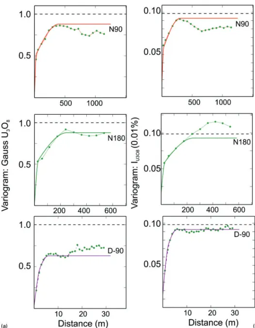
The highly skewed distribution of uranium grade (Fig. 10) represents an additional challenge for estimation resources of the sandstone-type deposits, which together with extremely complex geometry of this type deposits (Fig. 2) makes their resource estimation a highly challen-ging process. Conventional variograms of U3O8 grades
are usually very noisy therefore they are commonly modelled by transforming data to Gaussian distributed variables or using grade indicators (Goovaerts, 1997; Chiles and Delfiner, 1999). Both of these approaches can be used and usually improve the variograms (Fig. 11). Further improvement can be achieved if the geometry of the uranium rolls is simplified by straightening them using one of the available unfolding algorithms which are
7 3D litho-stratigraphic model of the mineralised aquifer at the Budenovskoe deposit, Shu-Sarysu basin, Kazakhstan
Table 3 Examples of the cut-offs used for definition uranium resources
Deposit Cut-off U3O8/wt-%
ISL operations
Inkai, Kazakhstan 0.010 Honeymoon, Australia 0.030 Open pit mining
Rossing, Namibia 0.015 Ranger, Australia 0.020 Langer Heinrich, Namibia 0.025 Trekkopje, Namibia 0.010 Polymetallic underground operation
Olympic Dam, Australia 30–70 US$/t
available within the majority of commercially available mining software packages.
Sandstone-type uranium mineralisation is charac-terised by strong variability of the uranium grade at short distances, which is clearly represented on the constructed variograms (Fig. 11). In general, geostatis-tical analysis suggests that 60 to 80% of the global variance at the studied sandstone-type uranium deposits occurs at distances of 30 to 80 m between data points (Tables 4 and 5). This observation accords well with the common practice of estimating Measured resources of the ISL uranium projects using tight drilling, commonly 25625 to 50625 m (Table 1).
Viability of the resources
The final stage of definition of resources of the ISL uranium projects is construction of the blocks which have reasonable prospects for eventual economic extraction
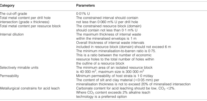
(JORC, 2012). This requires integration of the litho-stratigraphic model (Fig. 7) with the uranium grade model (Fig. 8) and implementing geological, hydrogeo-logical, geotechnical and economic parameters for con-straining the potentially mineable blocks. The parameters commonly used for constraining resource blocks are overall contained metal (product of grade by thickness), thickness of the mineralised intersection, thickness of the waste rocks in the constrained domains, thickness of the impermeable strata in the block and the concentration of the carbonates (Table 6). Contained metal is used for initial definition of the resource blocks. At the Kazakhstan deposits, the economic mineralisation is delineated at a 0?06 m*%U3O8 cut off value. This
parameter is higher at the Australian ISL projects; for example at the Honeymoon mine it varies from 0?18 to 0?51 m*%U3O8with a global average of 0?42 m*%U3O8
(McKay et al., 2007). The constrained block is further checked and corrected for internal waste and thickness of
9 Grouping of the domains by their grade-thickness characteristics and spatial distribution. Roll-type deposit in Shu-Sarysu basin, Kazakhstan (Abzalov, 2010). LG – low grade, HN – high grade narrow, HT – high grade thick: a grade vs thickness diagram of the mineralised intersections; b map showing spatial distribution of the mineralised intersections
10 Histograms of the drill holes uranium grades: a Budenovskoe deposit, Shu-Sarysu basin, Kazakhstan. Composite length is 0?5 m; b deposit in Great Divide basin. Composite length is 0?6 m
the enclosed impermeable layers (Table 6). The con-strained block is finally reported as resources only if overall permeability of the rocks is not less than 1?0 m/ day (Table 6). Mineralisation which does not meet the criteria shown in the Table 6 is reported as a low grade non-economic resource.
An example of a final resource block (1-5C1) constrained by using technical and economic parameters is presented in Fig. 12. This block was constructed by applying the criteria listed in Table 6 to the litho-stratigraphic and grade model of the deposit shown in Fig. 6. The uranium ISL resources in Kazakhstan are
11 Variograms (experimental and model) of transformed U3O8 grade at the rollfront uranium deposit in Great Divide
basin, Wyoming. N90 is along the strike of the roll, N180 across the strike, D-90 vertical: a Gaussian transformed; b U3O8indicator variable (I:U3O8.0.01)
Table 4 Example of the 3D variogram models applied for estimation resources of the roll type uranium deposits, Great Divide basin, USA
Deposit Modelled variable Nested structure Sill
Range
Comments Major axis Semi- axis Minor axis
Case 1 I: U3O8.0.02% Nugget 0.010 Nugget effect
Spherical – 1 0.017 60 60 3 Local component Spherical – 2 0.008 300 120 12 Regional component Case 1 I: U3O8.0.01% Nugget 0.015 Nugget effect
Spherical – 1 0.037 30 30 2.5 Local component Spherical –2 0.040 300 250 6 Regional component
reported in strict accordance with the assumed mining method, expected minimum mining dimensions and inter-nal mining dilutions which is compliant with reporting principles outlined in the JORC Code (JORC, 2012).
Concentration of carbonates is the main parameter for metallurgical characterisation of the ISL uranium resources, which requires determining a leaching system. Two chemical leaching systems are used: acid (IAEA, 2001) and alkali (McMurray, 1998). Acid leaching is faster and produces better recovery of uranium than alkaline leach. At the Honeymoon mine, Australia, direct compar-ison of the two approaches has shown that acid leach achieves 80% recovery of the in situ resources approxi-mately four times faster than using alkaline leach method (Bush, 2000). Acid leaching also allows recovery of some byproduct metals (Karimov et al., 1996). However, the acid leaching approach becomes inefficient when the host rocks contain carbonates because of excessively high acid consumption. In general, when the CO2content of the host
rocks exceeds 2%, acid leaching becomes economically non-viable for exploitation of the deposit.
An alternative approach is alkaline (sodium carbo-nate) leaching, which has been successfully used for sandstone deposits containing carbonates (McMurray, 1998). The alkaline leach method is also characterised by a high selectivity for uranium with a minimal attack on most gangue minerals, therefore alkaline solutions, in
general, are less corrosive and contain less impurities than sulphuric acid leach. These characteristics partially compensate for lower kinetics, less aggressiveness and the higher energy consumption of the alkaline leach method.
The parameters presented in Table 6 are the basis for developing modifying factors for conversion resources to reserves. The modifying factors are eventually developed by using field leach tests of uranium that the verification of parameters (Table 6) and where it is necessary to correct them adjusting to specific features of the studied project. The pilot production of uranium using a field leach test is a strict requirement for feasibility studies of the ISL uranium projects in Kazakhstan.
In general, the parameters presented in Table 6 can be used as an approximate guide for planning resource estimation programmes at the green field uranium ISL projects elsewhere. However, it should be remembered that these parameters are project specific and can vary depending on mineralisation depth, composition and permeability of the host rocks and aquifer characteristics.
Reconciliation of the resources
Publicly available data on reconciliation of the ISL uranium resources are very limited. In Kazakhstan
Table 5 Example of the two-dimensional variogram models estimated at the tabular type of the sandstone uranium deposit, Shu-Sarysu basin, Kazakhstan
Modelled variable Nested structure Sill
Range
Comments Major axis Minor axis
Gauss U3O8 Nugget 0.1 Nugget effect
Spherical – 1 0.3 85 50 Local component
Spherical – 2 0.6 450 150 Regional component
Gauss thickness Nugget 0.1 Nugget effect
Spherical – 1 0.5 120 60 Local component Spherical –2 0.4 440 200 Regional component
Table 6 Parameters for constraining economic mineralisation of uranium-ISL projects in Kazakhstan
Category Parameters
The cut-off grade 0.01% U Total metal content per drill hole
intersection (grade x thickness)
The constrained interval should contain not less than 0.060 m% U per drill hole Total metal content per resource block The constrained resource block (domain)
should contain not less than 0.1 m% U Internal dilution The maximum thickness of internal waste
within the mineralised envelops is 1 m Overall thickness of internal waste intervals
included in resource block (domain) should not exceed 6 m The minimum mineralisation-to-barren ratio is 0.75.
This is a ratio between the number of economic resource holes to the total number of holes within the outline of a resource block
Selectively minable units The minimum area of an isolated resource block is 40 000 m2, maximum size is 300 000 m2 Permeability Minimum permeability of host strata is 1.0 m/day
The content of silt and clay material (,0.05 mm) per
mineralisation thickness is not to exceed 20% of mineralised intersection Metallurgical constrains for acid leach Carbonate content for acid leaching should be low, CO2,2%.
Where CO2content exceeds 2% alkaline leach
the reported recovery is approximately 90% (Table 1), although lower than expected recovery was reported at the Budenovskoe project (Table 1), albeit in an early stage of production meaning that recovery rates can improve. Reported recovery rates at the Australian ISL uranium operations are significantly lower at 60–70% and dropping to 36% in silty sands (Daniel et al., 2007). At this stage it is not clear what is causing the low recovery rates at the Australian ISL uranium opera-tions. One of the possibilities is that recovery is hampered by a different kinetics of the in situ chemical reactions caused by high salinity of the ground water; however, this hypothesis needs to be investigated.
Summary and conclusions
The estimation and reporting of uranium resources for ISL projects is entirely based on drilling. The drill grid which are most commonly used for definition of ISL uranium resources are as follows:
(i) Measured: average 506100 m (range from 25650 to 506100 m)
(ii) Indicated: average 506200 m (range from 506100 to 506200 m)
(iii) Inferred: average 506400 m (range from 506400 to 1006800 m)
The drilling grids are used for classification resources in conjunction with consideration of the data quality. The preference is given to chemical assays of the drill core samples and properly calibrated PFN data. Minerali-sation in which grade is estimated using poorly calibrated historical gamma-ray data and not corrected for dis-equilibrium can be classified as Inferred resources at best. It should also be noted that the estimation and reporting of resources of the ISL uranium deposits differs from hard rock mining projects because they require quantitative
estimation of the geotechnical and hydrogeological para-meters that are specific for ISL technologies. The main parameters that need to be considered are as follows:
(i) hydrogeological confinement of the mineralised horizon, in particular water pressure at the aquifers and directions of the ground water flows (ii) chemistry of the ground waters
(iii) permeability and porosity of the mineralised horizon
(iv) composition of the host rocks in order to estimate if uranium mineralisation is amenable to dissolution by acid or alkaline solutions (v) grade and geometry of mineralisation are
estimated with accuracy sufficient for support-ing the remote minsupport-ing
(vi) rate of the in-situ dissolution of the uranium minerals.
Hydrogeological and geotechnical information is obta-ined by testing the drill core samples and in the field using pump tests and piezometers. Modifying factors for conversion resources to reserves are verified and corrected using field leach tests of uranium. This test is a strict requirement for feasibility studies of the ISL uranium projects in Kazakhstan.
Acknowledgements
Critical reviews of the paper by A. Abzalov, S. Hancock and two anonymous reviewers are gratefully acknowl-edged. The authors also express sincere gratitude to N. Phillips and S. Jowitt for editorial corrections that have helped to significantly improve the paper.
References
Abzalov, M. Z. 2010. Optimisation of ISL resource models by incorporating algorithms for quantification risks: Geostatistical 12 Cross-section of the Akdala deposit, ShuSarysu basin, Kazakhstan showing resource block (1-5C1) constrained using
approach. Technical meeting on in situ leach (ISL) uranium mining, International Atomic Energy Agency (IAEA), Vienna, Austria, 2010.
Abzalov, M. Z. 2012. Sandstone hosted uranium deposits amenable for exploitation by in-situ leaching technologies, Appl. Earth Sci. (Trans. Inst. Min. Metall. B), 121, (2), 55–64.
Abzalov, M. Z. and Humphreys, M. 2002. Resource estimation of structurally complex and discontinuous mineralisation using non-linear geostatistics: Case study of a mesothermal gold deposit in northern Canada, Explor. Min. Geol., 11, (1–4), 19–29. Abzalov, M. Z. and Paulson, O. 2012. Uranium deposits of the Great
Divide Basin, Wyoming, USA, Appl. Earth Sci. (Trans. Inst. Min. Metall. B), 121, (2), 76–83.
Abzalov, M. Z., Dumouchel, J., Bourque, Y., Hees, F. and Ware, C. 2011. Drilling techniques for estimation resources of the mineral sand deposits, Proc. Heavy Miner. Conf., Perth, Australia, October 2011, AusIMM, 27–39.
Armstrong, M., Galli, A., Beucher, H., Le Loc’h, G., Renard, D., Doligez, B., Eschard, R. and Geffroy, F. 2011. Plurigaussian simulation in geosciences, 2nd edn, Berlin, Springer.
Bush, P. D. 2000. Development considerations for the Honeymoon ISL uranium project, CIM Bull., 93, (1045), 65–73.
Chiles, J.-P. and Delfiner, P. 1999. Geostatistics: Modelling spatial uncertainty, New York, John Wiley and Sons.
Dahlkamp, F. J. 1993. Geology of the uranium deposits, 460, Berlin, Springer Verlag.
Daniel, C., Beinke, L., Pobjoy, R., Nesbitt, C. and Phillips, R. 2007. Variations in permeability and sedimentology and their effect on the in-situ leaching of the Beverly uranium deposit, Australia’s Uranium Conference, Darwin, Australia, May 2007, AusIMM, 15–16. Fontaine, L. and Beucher, H. 2006, Simulation of the Muyunkum uranium
roll front deposit by using Truncated Plurigaussian method, Proc. 6th Int. Min. Geol. Conf., Darwin, Australia, August 2006, AusIMM, 1–12. Goovaerts, P. 1997. Geostatistics for natural resources evaluation, New
York, Oxford, Oxford University Press.
IAEA, 2001. Manual of acid in situ leach uranium technology, TECDOC-1239, 283, Vienna, International Atomic Energy Agency. IAEA, 2009. World Distribution of Uranium Deposits (UDEPO) with
Uranium Deposit Classification, TECDOC-1629, 117, Vienna, International Atomic Energy Agency.
The JORC Code. 2012. The Australasian Code for Reporting of Exploration Results, Mineral Resources and Ore Reserves. [online]. Available at: http://www.jorc.org
Karimov, Kh. K., Bobonorov, N. S., Brovin, K. G., Goldshtein, R. I., Korsakov, Yu. F., Mazurkevich, A. P., Natalchenko, B. I., Tolstov, E. A. and Shmariovich, E. P. 1996. Uranium deposits of the Uchkuduk type in the Republic of Uzbekistan, 335, Tashkent, FAN (in Russian).
McKay, A. D., Stoker, P., Bampton, K. F. and Lambert, I. B. 2007. Resource estimation for in-situ leach uranium projects and reporting under the JORC Code, in Uranium Reporting Workshop, Uranium and the JORC Code. Adelaide, Australia, November 2007, The AusIMM, Adelaide branch.
McMurray, J. M. 1998. The United States uranium production industry: Survival in a turbulent market, World Uranium Mining Congress, Toronto, Canada, June 1998.
Penney, R. 2012. Australian sandstone-hosted uranium deposits, Appl. Earth Sci. (Trans. Inst. Min. Metall. B), 121, (2), 65–75. Penney, R., Ames, C., Quinn, D. and Ross. A. 2012, Determining
uranium concentration in boreholes using wireline logging techniques: comparison of gamma logging with prompt fission neutron technology (PFN), Appl. Earth Sci. (Trans. Inst. Min. Metall. B), 121, (2), 55–64.
Petrov, N. N., Berikbolov, B. R., Aubakirov, Kh. B., Vershkov, A. F., Lukhtin, V. F., Plekhanov, V. N., Cherniakov, V. M. and Yazikov, V. G. 2008. Uranium deposits of Kazakhstan (exo-genic), 2nd edn, 318, Almaty, Volkovgeologiia (in Russian). Pool, T. C. and Wallis, C. S. 2006a. Technical report on the South Inkai
uranium project, Kazakhstan, repared for Urasia Energy (BVI) Ltd, Roscoe Postle Associates Inc., Toronto, Canada.
Pool, T. C. and Wallis, C. S. 2006b. Technical report on the Akdala uranium mine, Kazakhstan, prepared for Urasia Energy (BVI) Ltd, Roscoe Postle Associates Inc., Toronto, Canada.
Pool, T. C. and Wallis, C. S. 2006c. Technical report on the North Kharasan uranium project, Kazakhstan, Prepared for Urasia Energy (BVI) Ltd, Roscoe Postle Associates Inc., Toronto, Canada. Skidmore, C. 2007. Resource estimation using prompt fission neutron (PFN) technology with examples from the Honeymoon uranium deposit, Uranium Reporting Workshop, Uranium and the JORC Code, Adelaide, Australia, November 2007, The AusIMM, Adelaide branch.