Initial stndy of terrestrial forces training sites
potentially contaminated by energetic
materials, CFB Petawawa
Marc-André Lavigne, Karine Champagne, Richard Martel and René Lefebvre
ISBN: 2-89146-316-1
Initial study of terrestrial forces training sites potentially contaminated
by energetic materials, CFB Petawawa
Study prepared for
Defence Research Establishment Valcartier (DREV) and CFB Petawawa
By
Marc-André Lavigne, Karine Champagne, Richard Martel and René Lefebvre INRS-ETE
Sainte-Foy, Québec
Avis
Le présent document a été conçu à l'aide des informations disponibles à l'époque, soit à l'été 2000. Depuis, certains travaux ont été réalisés ou sont en cours sur certains sites. La nature de ces travaux consiste principalement en la caractérisation des sites à laquelle s'ajoute des analyses d'échantillons d'eau. Pour connaître les derniers résultats, il est fortement suggéré de consulter des ouvrages émis après l'année 2000, s'il ya lieu. En somme, la présente classification ne tient pas compte des résultats recueillis après l'été 2000.
Notice
The CUITent document is a preliminary study. It has been made with the data available at Summer 2000. Since then, fieldwork have been undertaken on particular sites in order to have a better understanding of the hydrogeological system. Furthermore, water analysis have been realised on samples taken in the studied areas. For up to date information, it is suggested to verify if other documents, morerecent (2000-present), have been issued. This classification does not take into account the data acquired aft:er the summer 2000.
Résumé
Le présent rapport évalue le potentiel que pose les différents champs de tir de la base de Petawawa sur l'environnement et la santé humaine. Il traite des récents travaux d'évaluation environnementale effectués sur cette base. Ces travaux s'inscrivent dans le cadre d'un vaste projet de conformation et de gestion environnementale des bases militaires canadiennes entrepris par le Centre de Recherche pour la Défense Va1cartier (CRDV).
Le rapport contient en premier lieu une présentation générale de la base. La situation
géographique, l'historique et les activités actuelles ayant cours sur la base de Petawawa y sont décrits. Ensuite, les sites sélectionnés sont décrits en détail et sont évalués selon une méthode dérivée de celle du CCME (Conseil Canadien des Ministres de l'Environnement). Ces sites sont ceux où des matériaux énergétiques sont employés. Dans l'ensemble, le risque posé par ces sites est de moyen à fort, en raison des possibilités élevées de transport des matériaux énergétiques dans les eaux de surface et souterraines, ainsi que de la proximité des récepteurs potentiels.
Des conclusions et recommandations sont ensuite émises quant à la gestion des champs de tir de
Petawawa et quant aux possibilités d'améliorer les évaluations effectuées. Parmi celles-ci, une meilleure connaissance des eaux souterraines et du degré réel de contamination des sites pourraient aider à définir les risques sur les récepteurs potentiels avec plus de précision.
Abstract
The following report provides an assessment of the potential risk associated with the shooting ranges of CFB Petawawa with respect to the environment and human health. The report gives account of the recent environmental evaluation work of performed in this base. This work is part of a major environmental compliance and management project of the Canadian military bases undertaken by the Defence Research Establishment ofVa1cartier (DREV).
The report first provides a general introduction to the base. The geographic setting, the site history and the CUITent activities on the base are outlined. Then, the selected sites are described and evaluated with a method inspired by (and compatible with) the CCME's (Canadian Council of Ministers of the Environment) method. The sites are generally selected if their use involves energetic materials. The risk associated with the ranges is medium to high, due to the high migration potential of energetic materials in groundwater and surface water and due to the proximity of potential receptors.
Finally, conclusions and recommendations are made on the environmental management of the firing ranges and on the possible improvements to the evaluations, which were made of the sites. ArnQng others, a better knowledge of the hydrogeological settings and of the actual state of contamination on the base could help better define the possible receptors and environmental risks with more accuracy.
CONTENTS
TABLE LIST ... 6
1. INTRODUCTION ... 7
1.1 CONTEXT ...•... 7
1.2 EVALUATION METHOD ... 7
2 CHARACTERISTICS OF PETAWAWA CANADIAN FORCE BASE ... 9
2.1 GEOGRAPHIC AND CLIMA TIC BACKGROUND ... 9
2.2 PROPERTY'S BOUNDARIES ... 9
2.3 HISTORICAL AND ACTUAL ACTIVITIES ... 10
2.4 INFORMATION SOURCES ... Il 3. SITES STUDIED ... 12 3.1 TRAININGAREAD ... 12 3.1.1 Site characteristics ... 12 3.1.U 3.1.1.2 3.1.1.3 3.1.1.4 3.1.1.5 1.1.2 3.1.2.1 3.1.2.2 3.1.2.3 3.1.2.4 3.1.3 Geographie setting ... 12 Site boundaries ... : ... 12
Site history and activities ... 12
Description of installations ... 12
Geological, hydrogeological and hydrological contexts ... 12
Risk identification ... ... 14
Potential or known sources of contamination ... 14
Potential contaminants ... 14
Potential sources of contamination outside the site ... 15
Natural or human risks of increasing damages ... 15
Hazard eva/uation ... 16
3.1.3.1 Potential pathways for contaminants ... 16
3.1.3.1.1 Groundwater ... 16 3.1.3.1.2 Surface water ... 16 3.1.3.1.3 Aerial transport ... 16 3.1.3.2 Receptors ... 17 3.1.3.2.1 Humans ... 17 3.1.3.2.2 Other receptors ... 17
3.1.3.4 Potential hazards inherent in site ... 18
3.1.4 Prevention and emergency measures ... 19
3.1.5 Site classification ... ... 20
3.1.6 Recommendations and supplementary information required ... 21
3.2 DEMOLITION RANGE ...•...•... 22
3.2.1 Site characteristics ... 22
3.2.1.1 Geographie setting ... , ... 22
3.2.1.2 Site boundaries ... 22
3.2.1.3 Site history and activities ... 22
3.2.1.4 Description of installations ... 22
3.2.1.5 Geological, hydrogeological and hydrological contexts ... 22
3.2.2 Risk identification ... ... 24
3.2.2.1 Potential or known sources of contamination ... 24
3.2.2.2 Potential contaminants ... 24
3.2.2.3 Potential sources of contamination outside the site ... 24
3.2.2.4 Natural or human risks ofincreasing damages ... 24
3.2.3 Hazardevaluation ... 25
3.2.3.1 Potential pathways for contarninants ... 25
3.2.3.1.1 Groundwater ... 25 3.2.3.1.2 Surface water ... 25 3.2.3.1.3 Aerial transport ... 25 3.2.3.2 Receptors ... 26 3.2.3.2.1 Humans ... 26 3.2.3.2.2 Other receptors ... 26
3.2.3.3 Known contarrünation cases ... 26
3.2.3.4 Potential hazards inherent in site ... 27
3.2.4 Prevention and emergency measures ... 28
3.2.5 Site classification ... 29
3.2.6 Recommendations and supplementary information required ... 30
3.3 DZANZIOAREA 1 ... ·.31
3.3.1 Site characteristics ... 31
3.3. \.\ Geographie setting ... 3 \
3.3.\.2 Site boundaries ... , ... 3\
3.3.\.3 Site history and activities ... 3\
3.3.\.4 Description of installations ... 3\
3.3.\.5 Geological, hydrogeological and hydrological contexts ... 31
3.3.2 Risk identification ... 33
3.3.2.1 Potential or known sources of contarrünation ... 33
3.3.2.2 Potential contarrünants ... 33
3.3.2.3 Potential sources ofcontarrünation outside the site ... 33
3.3.2.4 Natural or human risks ofincreasing damages ... 34
3.3.3 Hazard evaluation ... 35
3.3.3.1 Potential pathways for contarrünants ... 35
3.3.3.1.1 Groundwater ... 35 3.3.3.\.2 Surface water ... 35 3.3.3.1.3 Aerial transport ... 35 3.3.3.2 Receptors ... 36 3.3.3.2.\ Rurnans ... 36 " 3.3.3.2.2 Other receptors ... 36
3.3.3.3 Known contarrünation cases ... 37
3.3.3.4 Potential hazards inherent in site ... 37
3.3.5 Prevention and emergency measures ... 38
3.3.5 Site classification ... 39
3.3.6 Recommendations and supplementary information required ... 40
3.4 IMPACT AREAA ... 41
3.4.1 Site characteristics ... 41
3.4.1.\ Geographie setting ... 41
3.4.\.2 Site boundaries ... 4\
3.4.1.3 Site history and activities ... 41
3.4.\.4 Description of installations ...•... 4\
3.4.1.5 Geological, hydrogeological and hydrological contexts .... ~ ... 42
3.4.2 Risk identification ... : ... 43
3.4.2.\ Potential or known sources of contarrünation ... 43
3.4.2.2 Potential contarrünants ... 43
3.4.2.3 Potential sources of contarrünation outside the site ... 44
3.4.2.4 Natural or hurnan risks of increasing damages ... 44
3.4.3 Hazard evaluation ... 45
3.4.3.1 Potential pathways for contarrünants ... 45
3.4.3.1.1 Groundwater ... 45
3.5.1.4 Descriptionofinstallations ... : ... 51.
3.5.1.5 Geological, hydrogeological and hydrological contexts ... 51
3.5.2 Risk identification ... 53
3.5.2.1 Potential or known sources of contanùnation ... 53
3.5.2.2 Potential contanùnants ... 53
3.5.2.3 Potential sources of contanùnation outside the site ... 54
3.5.2.4 Natural or hurnan risks ofincreasing damages ... 54
3.5.3 Hazard evaluation ... 55
3.5.3.1 Potential pathways for contanùnants ... 55
3.5.3.1.1 Groundwater ... 55 3.5.3.1.2 Surface water ... 55 3.5.3.1.3 Aerial transport ... 55 3.5.3.2 Receptors ... 56 3.5.3.2.1 Rumans ... 56 3.5.3.2.2 Other receptors ... 56
3.5.3.3 Known contanùnation cases ... : ... 57
3.5.3.4 Potential hazards inherent in site ... 57
3.5.4 Prevention and emergency measures ... 58
3.5.5 Site classification ... 59
3.5.6 Recommendatüms and supplementary information required ... 60
3.6 PETAWAWA GRENADE RANGE ... 61
3.6.1 Site characteristics ... 61
3.6.1.1 Geographic setting ... 61
3.6.1.2 Site boundaries ... 61
"3.6.1.3 Site history and activities ... 61
3.6.1.4 Description of installations ... 61
3.6.1.5 Geological, hydrogeological and hydrological contexts ... 61
3.6.2 Risk identification ... 63
3.6.2.1 Potential or known sources of contanùnation ... 63
3.6.2.2 Potential contaminants ... 63
3.6.2.3 Potential sources of contanùnation outside the site ... 63
3.6.2.4 Natural or human risks ofincreasing damages ... 63
3.6.3 Hazard evaluation ... 65
3.6.3.1 Potential pathways for contanùnants ... 65
3.6.3.1.1 Groundwater ... 65 3.6.3.1.2 Surface water ... ; ... 65 3.6.3.1.3 Aerial transport ... 65 3.6.3.2 Receptors ... 66 3.6.3.2.1 Rurnans ... 66 3.6.3.2.2 Other receptors ... 66
3.6.3.3 Known contanùnation cases ... 66
3.6.3.4 Potential hazards inherent in site ... 67
3.6.4 Prevention and emergency measures ... 68
3.6.5 Site classification ... 69
3.6.6 Recommendations and supplementary information required ... 70
3.7 IMPACTAREAS7 AND8 ... 71
3. 7.1 Site characteristics ... , ... 71
3.7.1.1 Geographic setting ... 71
3.7.1.2 Siteboundaries ... 71
3.7.1.3 Site history and activities ... 71
3.7.1.4 Description of installations ... 71
3.7.1.5 Geological, hydrogeological and hydrological contexts ... 72
3.7.2 Risk identification ... 73
3.7.2.1 Potential or known sources of contanùnation ... 73
3.7.2.2 Potential contanùnants ... 73
3.7.2.3 Potential sources of contanùnation outside the site ... 73
3.7.2.4 Natural or hurnan risks of increasing damages ... 73
3.7.3 Hazard evaluation ... 74
3.7.3.1 Potential pathways for contanùnants ... 74
3.7.3.1.1 Groundwater ... 74
3.7.3.\.3 Aeria\ transport ... 74
3.7.3.2 Receptors ... 75
3.7.3.2.\ Humans ... 75
3.7.3.2.2 Other receptors ... 75
3.7.3.3 Known contamination cases ... 75
3.7.3.4 Potentia\ hazards inherent in site ... 76
3.7.4 Prevention and emergency measures ... 77
3.7.5 Site classification ... 78
3.7.6 Recommendations and supplementary information required ... 79
4. GENERAL CONCLUSIONS AND RECOMMENDATIONS ... 80
REFERENCES ... 83
APPENDIX ... 84
TABLE LIST TABLE 1-POPULATIONS OF MUNICIPALlTIES AND PARISHES AROUND CFB PETAWAWA ... 10
TABLE 2 - CLEARANCE LEVELS ... 19
TABLE 3 -'-CLEARANCE LEVELS ... 28
TABLE 4 - CLEARANCE LEVELS ... 3 8 T ABI,.E 5 - CLEARANCE LEVELS ... 48
TABLE 6 - CLEARANCE LEVELS ... 58
TABLE 7 - CLEARANCE LEVELS ... 68
TABLE 8 - CLEARANCE LEVELS ... 77
1. Introduction
1.1 Context
While developing an environmental management pro gram for the Department of National Defence (DND) sites, it was agreed to do a study of the terrestrial forces training sites where the use of energetic materials could threaten the environment. This study, that represents a first step toward the environmental management of DND sites, will allow the identification and classification of potentially contaminated sites by energetic materials so that the need of complementary characterisation, the priority of intervention and the remedial actions be established. The study will also permit a synthesis of available information on each DND site to be done.
In this perspective, some training sites from Canadian Forces military Base (CFB) of Petawawa have been chosen by the DND and submitted to a preliminary evaluation of environmental risks. This evaluation, as weIl as a synthesis of the available information on each sites, are the subject of this study.
1.2 Evaluation method
The evaluation method used to classify potentially contaminated training sites is mainly based on the method developed by the Canadian Council of Ministersof the Environment (CC ME, 1992). The CCME's method is simple, reliable and versatile. However, a few adjustments inspired by a method developed by the French "Bureau des Recherches Géologiques et Minières" (BRGM, 1997) have been made in order to remedy the deficiencies of the CCME method. Consequently, the evaluation of each site will follow these steps (reference of documents in parenthesis) :
- Site description sheet (CCME)
- Checklist ofnecessary information (CCME) - Short evaluation form of site (CCME)
- Site classification (modified) worksheet (CCME &BRGM)
- Site classification computerised worksheet (Excel worksheet; INRS Géoressources)
A detailed description of CCME evaluation method and a summary of the modifications brought to it are presented in appendix A. Site classification computerised sheet can be found in appendix B, along with the documents corresponding to each step mentioned above.
The structure of the two studied methods (CCME and BRGM) is divided in three basic steps leading to a contamination:
1) Presence and characteristics of contaminants ; 2) Exposure pàthways of contaminant;
This structure has heen kept in the modified method.
Although the evaluation method gives a good idea of the site's risk potential, it does not provide a quantitative risk assessment. Furthermore, the study (consisting in the sites evaluations) is only a preliminary step. It should he completed with complementary characterisation studies in some cases. These actions can however he realised afterwards.
2
Characteristics of Petawawa Canadian force base
2.1 Geographie and climatic background
The CFB Petawawa is located in the Ottawa valley and more precisely in the Renfrew county
municipality. It is located at 150 km west of Ottawa and 200 km east of North Bay. Its current
area covers approximately 21 968 ha. Petawawa garrison's town is at the crossing of the Ottawa River and the Barron River (Topographic map MCE 132 TR89 Ed 7).
The eastern part of the Training and Range Area is mostly flat. There are sorne hills close to the Sturgeon Lake like Highview Tower Hill. Numerous lakes are found in this area. The western part of the CFB Petawawa is a less flat terrain. Many hills are found throughout the area. Once again, many lakes are found on this part ofthe base (see Appendix E for maps).
Except for the north-western part, CFB Petawawa is located within the Renfrew Climatic Region. Data show that the average annual temperature is approximately 5°C and that the mean annual precipitation is 711 mm. The mean annual surplus water of280 mm flows by runoff.
The western part of the Training and Range area is located in the Canadian Shield. Hence, the bedrock is mainly Precambrian rocks (metamorphic and intrusive). Amphibolite, granulite, mafic, ultramafic and anorthositic rocks are commonly found in this area. Over the bedrock, there are sorne irregular layers of deposits. During the quaternary period, the Champlain Sea was covering the Saint-Lawrence River valley and a part of the Ottawa River valley. This is why marine sediments are found in the eastern part of CFB Petawawa. These sediments are mostly fine sand and are surrounded by sandy till.
The drainage system of the CFB Petawawa is separated in four watersheds: the Ottawa River watershed, the Barron River watershed, the Petawawa River watershed and the Sturgeon Lake watershed. The Petawawa River is a tributary of the Barron River, which is, with the Sturgeon Lake, tributary of the Ottawa River. The direction flow of the Ottawa River is towards south. The Petawawa River is the only one that flows through the military base. Its direction flow is south-east while the Barron River flows towards south-east.
The study contains the evaluation of Il training sites that present a potential risk of contamination due to energetic materials. These areas include grenade ranges, impact ranges, demolition range, fighting in built up area (FIBUA) and field firing ranges (direct and indirect firing).
2.2 Property's boundaries
The limits of CFB Petawawa are mostly rivers, park and lakes. The Barron River borders the southern part of the Training Area. The west shore of the Ottawa River constitutes another border of the base. On the western side of the Training and Range Area, the Algonquin Provincial Park defines the border. However, the northern frontier is not weIl defined. It goes along First Egan
Lake, Corry Lake, Porch Lake and the western end of Sturgeon Lake but there sorne parts that simply go through the wooden area and do not follow any precise physical element.
There are a few municipalities located around the Training and Range Area. The most densely populated are Pembroke, Petawawa and Chalk River. Beside these larger cities, there are sorne parishes, which are formed due to the low population density in these areas. A li st of the main cities and parishes that surround CFB Petawawa is presented in table 1.
TABLE 1 - POPULATIONS OF MUNICIP AUTIES AND PARISHES AROUND CFB PETA W A WA
Municipalities Population
Petawawa 15015
Pembroke 70000
Chalk River 25000
Parishes
Black Bay NIA
Fort William NIA
2.3" Historical and actual activities
The government of Canada bought the land in 1904 but the military activities did not begin until 1905. Before World War I, the "A" and "B" Batteries of the Royal Canadian Horse Artillery, the infantry and the cavalry were training at the base. During the war, CFB Petawawa served as a training site for aU Canadian artillery units. Moreover, the Russian government, in accordance with the Canadian government, tested 100 mm shells made in Canada.
World War II gave to Petawawa military base an important role. Three training centres were in operation. There was one for the engineer units and two for the artillery units. The highest number of troops which were present and training during wartime was 20 000.
After the Second World War, Petawawa became a training site for the regular armyand sorne militia units as it was before. In 1948, the 1 st Battalion of the Royal Canadian Regiment and the Royal Canadians Dragoons settled at Petawawa. In 1951, the military base became officially a permanent camp and in 1966, it was renamed Canadian Forces Base Petawawa (CFB Petawawa).
- Signal units
These units are now garrisoned at the base. These units undergo routinely manoeuvres in the Training Area, which involves weapons and pyrotechnics. Small weapons are used on a daily basis either on conventional or on expediate ranges. Heavier weapons such as howitzer and mortar are also use but it occurs sporadically.
2.4 Information sources
Most information were found in the study conducted by Jacques Whitford Environment Lirnited and on the topographic map of the CFB Petawawa Range and Training Area (MCE l32 TR 89 Ed 7). Sorne information conceming either energetic rnaterials or the sites were also communicated through contacts at the CFB Petawawa and at the DREV. A list of the persons contacted is presented below.
Defence Research Establishment Valcartier (DREV)
• Stéphane Jean, Environmental agent
Petawawa rnilitary base (CFB Petawawa)
~ • Mr. Chris Hogan, Environmental officer
• Mr. Sean Moyles, Range Control officer
(418) 844 - 4000 ext. 4263
(6l3) 687-5511
Appendix C presents a table containing properties and criteria related to energetic materials. This table is also shown at the end of each site classification worksheet.
3. Sites studied
3.1 Training Area D
3.1.1 Site characteristics
3.1.1.1 Geographie setting
The Impact Area D, now known as the Training Area D, is located at the eastem part of CFB Petawawa and especially, between the square by these co-ordinates: 5092000m N, 5096700m N, 317800m E and 322250m E in the UTM system (NAD 83). The site covers an area of
ap-proximately 8.78314 km2
• This value inc1udes the area occupied by Chalk Bay and Clement
Lake. The range is characterised by a flat terrace bordered by a steep slope going towards Ottawa River's level on the eastem side and by another steep slope going uphill towards areas C and L's level. The soil along Chalk Bay is coyer with trees. As for the rest of the range, it is covered by either sand or grass. There are sorne fragile areas such as marshes along Clement Creek in the northem part of the area.
3.1.1.2 Site boundaries
AlI the limits are well defined on this site. The northem border goes along Deluthier Road. Both Chalk Bay and Ottawa River define the eastern limit. As for the western limit, it is representedby Thackray road. Finally, Bostwick Lake defines partly the southern limit.
3.1.1.3 Site history and activities
When CFB Petawawa started its activities at the beginning of the century, this area was used as an impact zone for artillery exercises. During the World War l, the Russian Army was testing the 100 mm shells on the eastern part of the base. The vocation of this site stood until a few years ago when it became a training area. Nowadays, no artillery exercise occurs in this area, but only troop manoeuvres.
and Ottawa Rivers. At that time, the great Champlain Sea was covering the Saint-Lawrence Valley and the Ottawa River Valley. However, there are sorne small areas near the northem border that show sorne outcrops sometimes covered by thin drift cover. As for Clement Point, the bedrock is undemeath a layer ofpoorly sorted tiii. Finally, the shore of the Ottawa River is more likely covered by modem unsubdivided alluvium like clay, silt, sand, gravel and muck.
The hydrogeological context is not well known due to the fact that no study was undertaken in the past. Hence, there are no monitoring well on the base. The only sampling campaigns were done few years ago by both provincial and federal govemments. The observation wells were set at the end of the Petawawa River. The analysis of water samples did not concem energetic materials, but showed a high concentration of nitrates and metals.
According to the nature of surface deposits, it seems that the aquifer is unconfined. As for the bedrock, it may allows water to flow rapidly or not. The velocity of water depends on the hydraulic conductivity, porosity and hydraulic gradient. Numerous factors influence the hydraulic conductivity like the porosity, the grain size and the presence of fractures. The higher this criteria is, the more easily the water can flows. In the case of Training Area D, the hydraulic conductivity of the bedrock has been neglected because of the lack of information and by comparison with the main material, which composed most of the surface deposits, i.e. the sand. The hydraulic con-ductivity of the sand has been estimated to vary between 10-5 mis and 10-2 mis because of its porous nature (Freeze and Cherry, 1979).
The depth of the water table is another important information that is unknown. The closer it is of the surface, the more rapidly the contaminants can reach it. No estimate has been done for this criteria because the classification form do not consider it.
The direction of groundwater flow is presumed to be towards south-west considering the Ottawa River and the Petawawa River as discharge zones. The Sand Plain itself constitutes a recharge zone of the aquifer due to its high permeability.
3.1.2 Risk identification
3.1.2.1 Potential or known sources of contamination
The potential sources of contaminant come from the use of explosive ammunitions, which contain energetic materials. The risk ofthreatening the environment occurs when these projectiles do not or partially explode. Once these duds are in the ground, there is a possibility that a leak occurs and then, cause sorne damages to the receptors located downstream.
3.1.2.2 Potential contaminants
The ammunitions used at Rocket Launcher Range are:
- ATGM BGM 7lAE HE (TOW) - BLANK AMMUNITION - CSRIOTGAS - GTG.38 - CTG.50mm - CTG5.56mm - CTG7.62mm - CTG9mm - CTG 38mm FLITERITE - CTG 38mm SPEDEHETE CS - CTG 60mm MOR HE - CTG 60mm MOR SMK WP - CTG 60mm MOR III - CTG 76mm HESH - CTG 76mmSHIP - CTG 76mmSMK (HOW) - CTG 81mm MOR HE - CTG 81mm MOR SMK WP - CTG81mmMORIII - CTG 84mm HEAT FFV 551
- PROJ155mmSMKWP - PYROTECHNICS - RKT2.75inHE
- RKT 21mm SUB-CAL(M72)
This ammunition list can be found in appendix D (Training Area Authorisation Form). Heavy metals and energetic materials are contained in these ammunitions. The ratios and weights of these materials are unknown.
Arnmunitions contain energetic materials that can decompose into numerous metabolites. These derivative products are sometimes more toxic and mobile than the original compound. TNT is a good example; there are approximately 21 metabolites. Sorne ofthese are even more soluble than the TNT itself.
3.1.2.3
Potential sources of contamination outside the siteAccording to the flow direction of surface water and topography, there is a low risk of con-tamination by other sites. The southem part of Impact Area A appears to be the most probable sourfe of contaminants. Otherwise, the neighbouring sites are not classified as dangerous area. Actually, the odds of finding unexploded ammunitions in the ground of Training Areas C, F and L are non-existent except if these sites were used as training manoeuvres with the support of ammunitions containing energetic materials. Special considerations must be make on groundwater flow direction and to the understanding of the role of watercourses in the base's area, i.e. whether or not they are recharge zones. If so, the concentration of energetic materials in groundwater would increases and hence, constitutes a greater danger for receptors susceptible to be in contact with it.
3.1.2.4
Natural or human risks of increasing damagesFew factors could increase the potential damages caused by a contamination with energetic materials. A decrease in the quality of ammunitions would cause an increase of non-exploded projectiles, which could be dangerous. Moreover, an increase in precipitation or less frequent cleaning of the site (leading to a greater possibility oftransfer of the energetic materials) could be harmful to the environment. Finally, levelling or bulldozing the soil could cause sorne duds to be buried in the ground, leading to a greater threat for the environment. Tanks or heavy vehicles movements can also be a cause of ground disturbance.
3.1.3 Hazard evaluation
3.1.3.1 Potential pathways for contaminants
Two pathways for transport of energetic materials are possible: aerial and aqueous. When a misfire occurs, the energetic materials present in the ammunition under a powdered form, can either be dissolved in water or be easily moved by the wind.
3.1.3.1.1 Groundwater
As known (see section 3.1.1.5), groundwater flow direction is not known due to the fact that no study on the hydrogeological context has been made. The hypothetical direCtion has been choose because 'of the sampling campaign done by both governments on the influence of military
activities on the quality ofwater. In regard of the Training Area D, groundwater would flows into
. Chalk Bay or into the Ottawa River.
As for the depth of the water table, it is also unknown. Even if this criteria is not taken into account into the classification, it is important to consider it. If the sand aquifer has a shallow water table, the contaminants will reach the water table more easily and the contaminant can spread in the aquifer.
The energetic materials undergo biodegradation, so does the metabolites. Sorne of these, derived from TNT are highly soluble. However, theyare also easily absorbed by organic matter and clay particles. This could exp Iain why the lest soluble RDX can travel as fast or more then TNT if biodegradation is considered (Thiboutot et al., 1998).
3.1.3.1.2 Surface water
Surface water appears to be another pathway considering the runoff. Chalk Bay and the Ottawa River are watersheds that border what is now Training Area D to the east and the north. The flow is towards south-east. As for Clement Lake, it drains water of the western part of the site and the eastern part of Training Area C. Clement Creek is a link, which is tributary ofthe Chalk Bay.
Otherwise, the others habitat possibly affected would be the aquatic fauna of the Ottawa River and the closest fragile areas, i.e. the marshes located along Clement Creek.
3.1.3.2 Receptors
Receptors are those located downstream of the site potentially contaminated with energetic materials. As for CFB Petawawa, the groundwater flow direction is assumed to be the same as the surface water. Receptors have been divided in two groups: humans and other receptors. This classification has been made to facilitate an overview of either living being or fragile areas that might be affected by a contamination with energetic materials. It does not suggest any value judgement. In fact, the same attention is provided to every receptors.
3.1.3.2.1 Humans
The closest city to the site is Fort William in the Province of Québec on the eastem shore of the Ottawa River. However, considering the flow direction of the river and the direction of the wind,
the Town of Petawawa located approximately 7 km south-east of the range, would be the most
probable receptor affected by a contamination by energetic materials. Furthermore, the water plant intake is situated downstream of the range.
People working on the site are mainly military personneL Moreover, they are healthy and aware ofhazards related to energetic materials.
3.1.3.2.2 Other receptors
This category contains both wildlife and vegetation. Large mammals such as White-tailed Deer, Moose and Black Bear can be found in this area. Other species living in this area include Red Fox, Beaver, Muskrat Grouse and Cottontail Rabbit.
As for marshes, they constitute fragile habitats that can easily be affected by any changes. Thus, there are sorne of these fragile areas along Clement Creek in the northem part of the range. A survey of the marshes did many years ago showed sorne high priority marshes in Training Areas C and L. The influence of energetic coming from Training Area D would have to be proved considering both groundwater flow direction and wind directions.
3.1.3.3 Known contamination cases
According to the Environmental Impact Assessment of Military Training Activities at CFB
Petawawa and to Mr. Chris Hogan, B.Env.O., there is no known contamination case caused by the past activities on Training Area D at CFB Petawawa either in the past or nowadays. However, the presence of old unexploded shells in the ground always constitutes a threat for troops and a potential source of contamination.
3.1.3.4 Potential hazards inherent in site
The site presents a high risk of soil erosion especially because of its proximity to the Ottawa River and to Chalk Bay. Furthermore, the lack of vegetation increases the sensitivity to aerial erosion of the area. Flood is another risk of propagation of energetic materials because of the relatively flat terrain. During a flood, all energetic materials particles would be in suspension and would undergo an aquatic transport until they set in place downstream. Moreover, explosion risks related to duds are a constant threat to military personnel especially if clearance operations are not conducted frequently.
3.1.4 Prevention and emergency measures
To our knowledge, no emergency measures were ever taken on the site since it has been operated. Nevertheless, clearance operation are not conducted on a regular basis. The philosophy of CFB Petawawa regarding unexploded shells is to wait until there is one reported and then, taking care of it. However roads and areas that have an extensively use have been in part clean. There is still a possibility that duds located deep in the ground come back to the surface because of the combining actions ofthaw/frost.
The last major clearance operation occurred in the late 80's. However, newly constructed roads and installations have been clean in order to create a zone where there is no doubt about security.
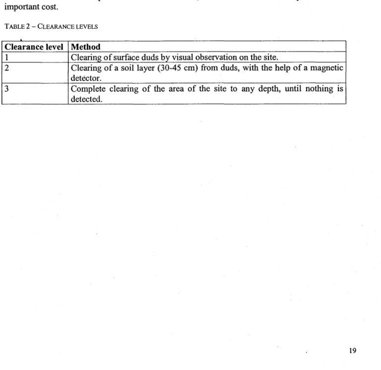
The following table shows the different level of clearance. Level 1 is the more frequently used. The only existing records of a level 2 clearance operation were for the construction of roads and other structures in the impact area 2. As for level 3, it is not often used mostly because of its important co st.
TABLE 2 - CLEARANCE LEVELS
Clearance level Method
1 Clearing of surface duds by visual observation on the site.
2 Clearing of a soillayer (30-45 cm) from duds, with the help of a magnetic
detèctor.
3 Complete clearing of the area of the site to any depth, until nothing is
3.1.5 Site classification
The Training Area Dis being given a score of72.7 ± 4.3 /100, or between 68.4 and 76 /100. This score puts the site in c1ass 1; thus, the potential risk is high. However, it could changes to a medium potential risk ifthere were more information available on this site. In orderto respect the limits, many special considerations have been lowered. The evaluation has been based on the uses of this site in the past years. Nowadays, there is no high explosives ordnance fired on this range. The sections conceming the environment, the groundwater and the surface water receive the maximum amount ofpoints because of the lack of information.
Threats to humans and to other receptors are quite low mostly because of the distance that separates the range from fragile areas.
As shown in the special considerations of section nA (groundwater), the adsorption of energetic materials on fine partic1es slows down the transfer from surface to the aquifer. This situation could facilitate an eventual c1eanup and makes biodegradation possible to occur before contamination reaches the aquifer.
The ... uncertainty associated to the total score originate from the lack of information regarding the availability of altemate drinking water supply, floodpotential and aerial transport.
3.1.6 Recommendations and supplementary information required
Due to the lack of information, many parts of the evaluation still involve sorne uncertainty. Sorne simple actions could be taken in order to improve knowledge on the site. This could probably lower the score of the range.
The first uncertainty concems the quantity of contaminants in presence. In the present situation, nature and quantity of the contaminants are unknown; this makes it difficult to estimate the importance of the contamination. Furthermore, because ofthis lack of information, contamination has been estimated with the area of the site, without knowing if contamination was effectively spread on the whole area. Consequently, it would be important to get further information on the nature and quantity of ammunition used. Knowing the exact impact or training locations (for example the locations of the targets used if so, would also help to estimate the real potentially contaminated area and to determine the direction followed by contaminants (this direction can vary depending on the part of the range where contamination occurs).
The other major point of uncertainty consists in the understanding of groundwater flow. It has been supposed that the aquifer lay in the quatemary deposits. Groundwater flow direction and hydtaulic conductivity of the sediments should be established; while waiting for information, groundwater has been supposed to go towards south-east, i.e. towards Ottawa River and hydraulic conductivity of the sand has been estimated between 10-5 and 10-2 mis (Freeze and Cherry, 1979). Hydraulic conductivity of sediments and hydraulic heads appear to be a key factor to localise the areas of recharge and dis charge of the aquifer.
Finally, information on possibility of aerial transport of energetic materials and on flood potential would help to get a more precise idea of the risks of contamination on and off the site. It is to be noted that a major c1eaning of the site helps to prevent contamination of the area and of the surroundings.
3.2 Demolition Range
3.2.1 Site characteristics
3.2.1.1 Geographie setting
The Demolition Range, is located within Impact Area 8 on the south-western part of CFB Petawawa and especially, at these co-ordinates: 305700m E and 5083300m N in the UTM system (NAD 83). The site covers an area is less than 1 km2
• The range is located in an area
characterised by important hills. However, the Demolition area is on a flat terrain. Biggar Lake is the closest basin approximately 300m north. That portion of Impact Area 8 is covered with grass and sand, but surrounded by trees and marshes. These marshes are considered as fragile habitats. They are concentrated around Biggar Lake and along Biggar Creek.
3.2.1.2 Site boundaries
The Demolition Range is located within the Area 8 and especially at the southern part of it. There is no particular physical feature, which could delimit precisely the area. Biggar Lake and Biggar
Lak~ Road are the only features present within the range and the security area. 3.2.1.3 Site history and activities
When CFB Petawawa started its activities at the beginning of the century, the eastern areas were used as impact zones for artillery exercises. During the World War 1, the Russian Army was testing the 100 mm shells at Petawawa. Gradually, the govemment expropriated the lands located in the western part. Progressively, military exercises were undergoing in the western part of CFB Petawawa leaving the eastern areas as dry-firing ranges.
3.2.1.4 Description of installations
The area where duds are destroyed do not exceed 3 ha. It is a small range surrounded by a fireguard and a wired fence. Near the gate, there is a bunker where military personnel can witness the destruction of ammunition, explosives, etc.
According to the nature of surface deposits, it seems that the aquifer is unconfined. As for the bedrock, it may allows water to flow rapidly or not. The velocity of water depends on the hydraulic conductivity, porosity and hydraulic gradient. Numerous factors influence the hydraulic conductivity like the porosity, the grain size and the presence of fractures. In the case of the Demolition Range, the hydraulic conductivity of the bedrock has been neglected because of the lack of information and its nature. The comparison with the materials that overlain the bedrock, i.e. gravel, gravely sand, sand and poorly sorted tilI. The hydraulic conductivity of the deposits has been estimated to vary between 1O-l2 mis and 10-2 mis depending of the material and its porous nature (Freeze and Cherry, 1979).
The depth of the water table is another important information that is unknown. The closer it is of the surface, the more rapidly the contaminants can reach it. No estimate has been done for this criteria because the classification form do not consider it.
The groundwater flow direction is presumed to be towards south-west considering the Barron River as a discharge. As for the recharge areas, there is no information that specified where the aquifer recharges. However, mountains are usually known to be a recharge zone due to the contact between bedrock and permeable surface deposits. The influence of Biggar Lake is not well"known. It could be either a discharge or a recharge zone.
3.2.2 Risk identification
3.2.2.1 Potential or known sources of contamination
The potential sources of contaminant come from the use of explosive ammunitions which contain energetic materials. The risk of threatening the environment occurs when these projectiles do not or partially explode. Once these duds are in the ground, there is a possibility that a leak occurs and then, cause sorne damagesto the receptors located downstream.
3.2.2.2 Potential conta minants
The ammunitions used at Rocket Launcher Range are:
- EXPLOSIVES
This ammunition list can be found in appendix D (Training Area Authorisation Form). Heavy metals and energetic materials are contained in these ammunitions. The ratios and weights of this material are unknoWn.
Ammunitions contain energetic materials that can decompose into numerous metabolites. These derivative products are sometimes more toxic and mobile than the original compound. TNT is a good example; there are approximately 21 metabolites. Sorne of these are even more soluble than the TNT itself.
3.2.2.3 Potential sources of contamination outside the site
According to the flow direction of surface water and topography, there is a risk of contamination by other sites. The Impact Area 8 constitutes the most probable source of contaminants because the Demolition Range is a part of it. Otherwise; the neighbouring sites do not appear to be potential sources of contamination. Area P and Area Q are not c1assified as dangerous, which lower the possibility of finding duds in the ground. As for Impact Area 6, its location downstream of the Demolition Range c1assify this site as potentially contaminated. Finally, the Petawawa River separates Impact Area 7 from Impact Area 8. It implies that energetic materials will go downstream. Considerations on the groundwater flow direction must be made to provide a good analysis of a particular site.
3.2.3 Hazard evaluation
3.2.3.1 Potential pathways for contaminants
Two pathways for transport of energetic materials are possible: aerial and aqueous. When a misfire occurs, the energetic materials present in the ammunition under a powdered form, can either be dissolve in water or be easily moved by the wind.
3.2.3.1.1 Groundwater
As known (see section 3.2.1.5), groundwater flow direction is not known due to the fact that no study on the hydrogeological context has been made. The hypothetical direction has been choose because of the sampling campaign done by both governments on the influence of military activities on the quality of water. In regard of the Demolition Range, groundwater would flows into Barron River.
As for the depth of the water table, it is also unknown. Even if this criteria is not taken into account in the classification, it is important to consider it. If the aquifer has a shallow water table, the eontaminants will reach the water table more easily and the contaminants can spread in the aquifer.
The energetic materials undergo biodegradation, so does the metabolites. Sorne of these, derived from TNT are highly soluble. However, they are also easily absorbed by organic matter and clay particles. This could explain why the lest soluble RDX can travel as fast or more then TNT if biodegradation is considered (Thiboutot et al., 1998).
3.2.3.1.2 Surface water
Surface water appears to be another pathway considering the runoff. The Demolition Range does not have any well-defined border like river, pond or lake. However, Biggar Lake is located in the middle of the area. It de fines the area as well drained. According to the topography, surface water flows towards the centre. Biggar Creek drains the water to the Barron River, which is the closest watershed in this part of the Training Area. There are sorne wetlands surrounding Biggar Lake that might be affected by energetic materials.
3.2.3.1.3 Aerial transport
Explosive compounds such as RDX, TNT and HMX are not volatile. Furthermore, they are under a powder state when used in ammunitions. However, there is a possibility particles present at the surface of the ground undergo an aerial transport. What also happen is that these explosive materials can be absorbed by soil particles, which are also susceptible to aerial transport. It exists sorne ammunition, which contain energetic materials that release toxic fumes while burning. For example, the hexachloroethane (HC) fumes are harmful to the fauna and flora because of their toxicityand their persistence in the environment.
The wind has a relatively important influence on the Petawawa ranges. Eastern lands were in the past and nowadays influenced by the wind. As for the western lands, their rocky composition lowers· the wind incidence. However, drift cover might undergo an aerial transport. For this reason, aerial transport can not be neglected. Predominant winds are usually coming from west, south-west and north-west. As for the velocity, ranges from 13 kmIh to 17 kmIh depending on its direction (Climatic atlas of Canada, 1988).
The CFB Petawawa is located in a remote area. The closest city is located far east of the Demolition Range. Beside the Town of Petawawa (including the garrison), the lands that might be influenced by the energetic materials
3.2.3.2 Receptors
Receptors are those located downstream of the site potentially contaminated with energetic materials. As for CFB Petawawa, the groundwater flow direction is assumed to be the same as the surface water. Receptors have been divided in two groups: humans and other receptors. This classification has been made to facilitate an overview of either living being or fragile areas that rnight be affected by a contamination with energetic materials. It does not suggest any value judg.ement. In fact, the same attention is provided to every receptors.
3.2.3.2.1 Humans
CFB Petawawa is located in a remote area of north-eastern Ontario. The cities surrounding the base have for the majority, a low population. Ifwe consider the groundwater flow, the cities that is the more likely to be affected would be the garrison and the town of Petawawa and other municipalities that have its water supplies downstream into the Ottawa River. Otherwise, the remoteness of the range lower the risks that energetic materials that are undergoing an aerial transport affect the cities in the areas surrounding the base.
People working on the site are mainly military personnel. Moreover, they are healthy and aware ofhazards related to energetic materials.
3.2.3.2.2 ·Other receptors
According to the Environmental Impact Assessment of Military Training Activities at CFB Petawawa and to Mr. Chris Hogan, B.Env.O., there is no known contamination case caused by
the past activities on Demolition Range at CFB Petawawa either in the past or nowadays. However, the presence of old unexploded shells in the ground always constitutes a threat for troops and a potential source of contamination.
3.2.3.4 Potential hazards inherent in site
The site shows a high risk of soil erosion especially because of the presence of Biggar Lake within the area. However, the vegetation that partly surrounds the lake lowers the sensitivity to both aerial and water erosion. The terrain just east of the lake is treeless which makes it propitious to both erosion and flooding. If these events occur, energetic material particles would be in suspension and undergo an aquatic transport until they set in place downstream. Moreover, explosion risks related to duds are a constant threat to military personnel especially if clearance operations are not conducted frequently.
3.2.4 Prevention and emergency measures
To our knowledge, no emergency measures were ever taken on the site since it has been operated. Nevertheless, clearance operation are not conducted on a regular basis. The philosophy of CFB Petawawa regarding unexploded shells is to wait until there is one reported and then, taking care of it. As for the Demolition Range, the presence of UXO in the ground is probable but do not represent a major concem. The issue is more the residues of energetic material thrown away after an explosion.
There is still a possibility that duds located deep into the ground of the security area fired a long time ago come back to the surface because of the combining actions of thaw/frost.
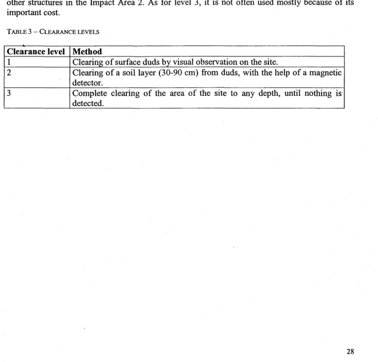
The following table shows the different leve1s of clearance. Leve1 1 is the more frequently used. The only existing records of a level 2 clearance operation were for the construction of roads and other structures in the Impact Area 2. As for level 3, it is not often used mostly because of its important co st.
TABLE 3 - CLEARANCE LEVELS
Clearance level Method
1 Clearing of surface duds by visual observation on the site.
2 Clearing of a soillayer (30-90 cm) from duds, with the help of a magnetic
detector.
3 Complete clearing of the area of the site to any depth, until nothing is
3.2.5 Site classification
The Demolition Range receives a score of 61 ± 4.3 /100 or ranging from 56.7 to 65.3 /100. This grade puts the site in class 2 and the risk potential associates with this classification is medium.
Higher grades were given for the groundwater, surface water and the receptors. The lack of information conceming the geological, hydrogeological and hydrological contexts forced us to sorne suppositions especially for the flow direction of water in and on the ground. As for the hydraulic conductivity of the aquifer, it was estimated in accordance with the nature of the surface deposits and to with the chart of values of hydraulic conductivity and permeability (p.34 of the site classification worksheet). However, the map of the surface deposits was not precise enough to characterise the real nature of materials in place. That is why an average value of hydraulic conductivity was given. There was no trace of engineered or natural containment system. The presence of Biggar Lake can not be neglected. In fact, we think it represents the main drainage basin and the potential pathway for the contaminants contained in runoff water by spreading down the slopes beside the lake and then, towards Biggar Creek. The marshes around the lake increase the score for the presence of fragile sites to its maximum value.
The "receptors received a low grade because of the remoteness of the site. The closest village is
Black Bay located approximately 10 km east. Another reason is that the site is within the Impact
Area 8 where ordnance land. Furthermore, only military personnel has an access to this part of the base
Even if the Demolition Range had a low score, it does not mean that there is no chances of a contamination by energetic materials. On the contrary, it is on these small areas often usèd that the concentration of contaminants in water ought to be higher than usuaI. If traces of TNT, RDX or HMX are in the water, it would be hard to determine the real influence of the Demolition Range. For this reason, it is important to see the global influence of the ranges upstream and see which sites had and still have an extensive use that could be directly related to the contamination.
As shown in the special considerations of section lIA (groundwater), the adsorption of energetic materials on fine particles slows down the transfer from surface to the aquifer. This situation could facilitate an eventual cleanup and makes biodegradation possible to occur before contamination reaches the aquifer.
The uncertainty associated to the total score originate from the lack of information regarding the availability of altemate drinking water supply, flood potential and aerial transport.
3.2.6 Recommendations and supplementary information required
Due to the lack of information, many parts of the evaluation still involve sorne uncertainty. Sorne simple actions could be taken in order to improve knowledge on the site. This could probably lower the score of the range.
The tirst uncertainty concems the quantity of contaminants in presence. In the present situation, nature and quantity of the contaminants are unknown; this makes it difticult to estimate the importance of the contamination. Furthermore, because of this lack of information, contamination has been estimated with the area of the site, without knowing if it was effectively spread on the whole area. Consequently, it would be important to get further information on the nature and quantity of materials destroyed;
The other major point of uncertainty consists in the understanding of groundwater flow. It has been supposed that the aquifer lay in the quatemary deposits. Groundwater flow direction and hydraulic conductivity of the sediments should be established in order to ob tain these data necessary to know the direction a potential contamination would follow. While waiting for information, groundwater has been supposed to go towards south-east, i.e. towards the Barron
River and hydraulic conductivity of the surface deposits has been estimated to range between 10-8
and 10-02 mis (Freeze and Cherry, 1979). Hydraulic conductivity of sediments and hydraulic heads appear to be a key factor to localise the areas of recharge and discharge of the aquifer.
Finally, information on possibility of aerial transport of energetic materials and on flood potential would help to get a more precise idea of the risks of contamination on and off the site. It is to be noted that a major cleaning of the site helps to prevent contamination of the area and of the surroundings.
3.3 DZ Anzio Area 1
3.3.1 Site characteristics
3.3.1.1 Geographie setting
The DZ Anzio Area 1 is located at the eastern part of CFB Petawawa and especially, between the square fonned by these co-ordinates: 5089350m N, 5092450m N, 315000m E and 318200m E in
the UTM system (NAD 83). The site covers an area of approximately 5.44656 km2
• The range is
characterised by a flat terrain with small hills sparsely located. The soil along Highway 17 and along hnpact Area 4' s limit is coyer with trees. The rest of the range looks like a corridor covered by either sand or grass. There are sorne fragile areas such as marshes along Tucker Creek in the northern part of the hnpact Area 4.
3.3.1.2 Site boundaries
The DZ Anzio Area l 's borders are well defined. Actually, this site is located within the area defined by Gust Trail, Old Bran Road, Stewart Road, tucker Road, Orange Road and Road 17.
o.
3.3.1.3 Site history and activities
When CFB Petawawa started its activities at the beginning of the century, this area was used as an impact zone for artillery exercises. During the World War l, the Russian Anny was testing the 100 mm shells on the eastem part of the base. The vocation of this site stood until a few years ago when it became a training area. Nowadays, no artillery exercise occurs in this area, but only troop manoeuvres.
3.3.1.4 Description of installations
The access to this site is controlled by eight gates. On the southem part ofthe area, there are gates ID and 1C which control the access to Gust Trail. As for the northem part, gate 4C restrains the access to Tucker Lake Road from Orange Road. The western part of the area contains three gates. Two ofthese gates, i.e. 4A and 4B, control the access to TotalizeRoad that goes across the area. As for the third one( 4G), it restrains the traffic coming from the south on Old Bran Road. Finally, gates lA and lB control the eastem side of the area that come from Messer Trail. Their is also a building within the area located west of gate lA.
3.3.1.5 Geological, hydrogeological and hydrological contexts
The geology of DZ Anzio Area 1 is composed of limestone, minor dolostone, shale and sand-stone. The bedrock is mostly overlain by fine sand. This layer of sediments is commonly known as the Petawawa Sand Plain. This plain was fonned during the Quatemary Period by a delta fonned by Petawawa, Barron, Indian and Ottawa Rivers. At that time, the great Champlain Sea was covering the Saint-Lawrence Valley and the Ottawa River Valley.
The hydrogeological context is not well known due to the fact that no study was undertaken in the past. Renee, there are no monitoring well on the base. The only sampling campaigns were done few years ago by both provincial and federal governments. The monitoring wells were set at the end of the Petawawa River. The analysis of water samples did not concem energetic materials, but showed a high concentration of nitrates and metals.
According to the nature of surface deposits, it seems that the aquifer is unconfined. As for the bedrock, it may allows water to flow rapidly or not depending on its nature and . The velocity of water depends of the hydraulic conductivity, porosity and hydraulic gradient. Numerous factors influence the hydraulic conductivity like the porosity, the grain size and the presence of fractures. In the case of DZ Anzio Area 1, the hydraulic conductivity of the bedrock has been neglected because of the lack of information and by comparison with the main material, which composed most of the surface deposits, i.e. the fine sand. The hydraulic conductivity of the fine sand has been estimated to vary between 10-6 mis and 10-4 mis because of its relatively porous nature (Freeze and Cherry, 1979).
The depth of the water table is another important information that is unknown. The closer it is of the surface, the more rapidly the contaminants can reach it. No estimate has been done for this criteria because the classification form do not consider it. ... .
The groundwater flow direction is presumed to be towards south-west considering the Ottawa River and the Petawawa River as discharge zones. The Sand Plain itself constitutes a recharge zone of the aquifer due to its high permeability.
3.3.2 Risk identification
3.3.2.1 Potential or known sources of contamination
The potential sources of contaminant come from the use of explosive ammumtlOns, which contain energetic materials. The risk of threatening the environment occurs when these projectiles do not or partially exp Iode. Once these duds are in the ground, there is a possibility that a leak occurs and then, cause sorne damages to the receptors located downstream.
3.3.2.2 Potential contaminants
The ammunitions used at DZ Anzio Area 1 are:
- BLANK AMMUNITION - CSRIOTGAS - CTG .50mm - CTG5.56mm - CTG7.62mm - CTG9mm - CTG 38mm FLITERITE CS - CTG 38mm SPEDEHETE CS - PYROTECHNICS
This ammunition list can be found in appendix D (Training Area Authorisation Form). Heavy metals and energetic materials are contained in these ammunitions. The ratios and weights of these materials are unknown.
Ammunitions contain energetic materials that can decompose into numerous metabolites. These derivative products are sometimes more toxic and mobile than the original compound. TNT is a good example; there are approximately 21 metabolites. Sorne ofthese are even more soluble than the TNT itself.
3.3.2.3 Potential sources. of contamination outside the site
According to the flow direction of surface water and topography, there is a low risk of contamination by energetic materials coming from other sites. Preferential pathway of surface water outside the site is more likely towards west and south. Other neighbouring sites are not classified as danger areas. The risk of contamination by water coming from Area C, E, L and 0 is improbable. Special considerations must be make on groundwater flow direction. In addition, the understanding of the role of waterways in the base's are a, i.e. whether or not they are recharge zones. If so, the concentration of energetic materials in groundwater would increases and hence, constitutes a greater danger for receptors susceptible to be in contact with it.
3.3.2.4 Natural or human risks of increasing damages
Few factors could increase the potential damages caused by a contamination with energetic materials. A decrease in the quality of ammunitions would cause an increase of non-exploded projectiles, which could be dangerous. Moreover, an increase in precipitation or less frequent cleaning of the site (leading to a greater possibility oftransfer of the energetic materials) could be harmful to the environment. Finally, levelling or bulldozing the soil could cause sorne duds to be buried in the ground, leading to a greater threat for the environment. Tanks or heavy vehicles movements can also be a cause of ground disturbance.
3.3.3 Hazard evaluation
3.3.3.1 Potential pathways for contaminants
Two pathways for transport of energetic materials are possible: aerial and aqueous. When a misfire occurs, the energetic materials present in the ammunition under a powdered form, can either be dissolve in water or be easily moved by the wind.
3.3.3.1.1 Groundwater
As known (see section 3.3.1.5), groundwater flow direction is not known due to the fact that no study on the hydrogeologicalcontext has been made. The hypothetical direction has been choose because of the sampling campaign done by both governments on the influence of military activities on the quality of water. In regard of the DZ Anzio Area 1, groundwater would flows towards Petawawa River.
As for the depth of the water table, it is also unknown. Even if this criteria is not taken into account in the classification, it is important to consider it. If the aquifer has a shallow water table, the ~ontaminants will reach the water table more easily and the contaminants can spread in the aquifer.
The energetic materials undergo biodegradation, so does the metabolites. Sorne of these, derived from TNT are highlysoluble. However, they are also easily absorbed by organic matter and clay particles. This could explain why the lest soluble RDX can travel as fast or more then TNT if biodegradation is considered (Thiboutot et al., 1998).
3.3.3.1.2 Surface water
Surface water appears to be another pathway considering the important runoff. Soils and surface deposits are mostly composed of fine sand. The DZ Anzio Area 1 does not have any weil defined border like river, pond or lake. However, Tucker Creek and Duke Lake are the closest basin where surface water could tip into it by runoff because of the absence of watercourse within the area. Due to the important distance which separate basins from this area, it is considered as poorly drained. There are sorne wetlands located along Tucker Creek that might be affected by energetic materials and then, flow towards Sturgeon Lake.
3.3.3.1.3 Aerial transport
Explosive compounds such as RDX, TNT and HMX are not volatile. When used in ammunition, they are under a powder state. After the explosion, there is a possibility that particles present at the surface of the ground or in the air undergo an aerial transport. Another possibility would involve that these explosive materials can be absorbed by soil particles, which are also susceptible to aerial transport. Sorne ammunitions contain energetic materials that release toxic fumes while burning. As an example, the hexachloroethane (HC) fumes are harmful to the fauna and flora because oftheir persistence in the environment.
The wind has a relatively important influence on the Petawawa ranges. Western lands with their rocky composition are not so influenced by the wind. As for the eastern lands, the sandy content in the surface materials are more propitious to be modified by the wind. Drift cover might undergo an aerial transport. For this reason, aerial transport can not be neglected especially at DZ Anzio Area 1 where records show the modifications of the topography trough time. Impact Area A is a different case because of its highly dense wooded areas and the use of non explosive ordnances. Predominant winds are usually coming from west, south-west and north-west. As for the velocity, it ranges from 13 km/h to 17 km/h depending on its direction (Climatic atlas of Canada, 1988).
The direction of the wind varies a lot, but is more often towards east. If an aerial transport occurs due to the destruction or the leakage of unexploded shells, the cities that are more likely to be affected are Petawawa (south-east) and Fort William (East). Otherwise, the others habitat possibly affected would be the aquatic fauna of the Ottawa River and the closest fragile areas, i.e.
the marshes located along Clement Creek.
3.3.3.2 Receptors
Receptors are those located downstream of the site potentially contaminated with energetic
"
materials. As for CFB Petawawa, the groundwater flow direction is assumed to he the same that surface water. Receptors have been divided in two groups: humans and other receptors. This classification has been made to facilitate an overview of either living being or fragile areas that might be affected by a contamination with energetic materials. It does not suggest any value judgement. In fact, the same attention is provided to everyreceptors.
3.3.3.2.1 Humans
The closest city to the site is the Town of Petawawa that would be the most probable receptor affected by a contamination by energetic materials.
People working on the site are mainly military personnel. Moreover, they are healthy and aware ofhazards related to energetic materials.
3.3.3.3 Known contamination cases
According to the Environmental Impact Assessment of Military Training Activities at CFB
Petawawa and to Mf. Chris Hogan, B.Env.O., there is no known contamination case caused by
the past activities on DZ Anzio Area 1 at CFB Petawawa either in the past or nowadays. However, the presence of old unexploded shells in the ground always constitutes a threat for troops and a potential source of contamination.
3.3.3.4 Potential hazards inherent in site
The site presents a low risk of soil erosion especially because of the distance that separates it from the closest basins. However, the absence of vegetation and the type of surficial deposits, i.e. fine sand, constitute a propitious environment to aerial erosion and erosion caused by runoff water. Flooding in this area are not considered as a potential hazard due to the distance to Ottawa River. Moreover, explosion risks related to duds are a constant threat to military personnel especially if clearance operations are not conducted frequently.