Hosting by Elsevier B.V. All rights reserved DOI: 10.1016/S1672-6308(14)60282-1
Elevation and Land Use Types Have Significant Impacts on
Spatial Variability of Soil Organic Matter Content in Hani
Terraced Field of Yuanyang County, China
LI Feng-bo
1, LU Guang-de
2, ZHOU Xi-yue
1, NI Hui-xiang
2, XU Chun-chun
1, YUE Chao
2,
Y
ANG Xiu-mei2, FENG Jin-fei
1, FANG Fu-ping
1(1
Rice Science & Technology Information Center, China National Rice Research Institute, Hangzhou 310006, China; 2Agro-Tech Extension Center of Yuanyang, Honghe 662400, China)
Abstract: Soil organic matter (SOM) content is one of the most important indicators of the sustainability of soil. To maintain sustainable soil utilization and management in fragile Hani terraced field, it is meaningful to investigate the effects of topography and land use type on SOM content. Descriptive statistics and geostatistics were used to analyze the data and the kriging method was applied to map the spatial patterns of SOM content. The results showed that the mean SOM content was 32.76 g/kg, with a variation coefficient of 40%. The SOM content was affected by elevation and land use type. As the increase of elevation, the SOM content in Hani terraced field also increased obviously. The SOM content in tea garden, which is almost at high elevation, was the highest in all six land use types, and the SOM content decreased in a following sequence: tea garden > paddy field > corn field > banana garden > cassava field > sugarcane field. In addition, at the same elevation, the paddy field had the highest SOM content compared with other land use types. All these results demonstrate that paddy field is the most efficient and suitable land use type for SOM conservation at high, middle or low elevations in the fragile Hani terraced field. In order to protect soil quality and maintain the sustainable agricultural development, it is necessary to maintain or even to enlarge the area of paddy field in Yuanyang county, Yunnan Province, China.
Key words: Hani terraced field; elevation; land use type; geostatistics; soil organic matter content
As the product of on-site biological decomposition, soil organic matter (SOM) affects the chemical and physical properties of soil and its overall health. Also, the composition and breakdown rate of SOM affect structure and porosity, water infiltration rate and moisture holding capacity, diversity and biological activity, and plant nutrient availability of soil (Bot and Benites, 2005). Accurate information of the spatial variation of SOM content is extremely critical for sustainable soil utilization and management (Zhang et al, 2012). Therefore, the spatial variation of SOM content and its influence factors are becoming hot spots in studying of soil science, ecology and geochemistry.
Scholars have performed numerous studies on the spatial distribution of SOM content in various countries, regionals and ecosystem scales, such as China (Li Q Q
et al, 2012), Taiyuan (Zhang et al, 2009), urban-rural transition zone of Beijing (Hu et al, 2007), eastern Canada (Mabit and Bernard, 2010), small watershed of the Loess Plateau (Fang et al, 2012), river marginal wetlands (Bai et al, 2005), Qinghai Lake (Cao et al, 2011) and different agricultural ecosystems (Yang et al, 2008). These studies had a high consistence with spatial heterogeneity in SOM content, and revealed its influence factors including climate, topography, natural vegetation, texture, drainage, soil erosion, cropping and tillage, crop rotations, nutrients and others. Of all these factors, land use type is the most sensitive to human disturbance (Fang et al, 2012). Therefore, monitoring SOM contents in different land use types is essential for estimating SOM distribution.
Terraced field is one of the most important land types for agricultural products in hilly and mountainous areas of China. According to statistics, the cultivated area with a slope greater than 8° is 3.334 × 10⁷ hm2,
Received: 11 February 2014; Accepted: 30 October 2014 Corresponding author: FANG Fuping (fangfuping@163.com)
accounting for 35.11% of the cultivated area in China. In China, the hilly and mountainous areas are widely distributed in northeast, southeast, south, southwest, Loess Plateau and Qinba Mountain area. The area of slope farmland in hilly and mountainous areas of Southeast, South and Southwest China is 1.669 × 10⁷ hm2, which occupies 43.1% of total hilly area and 17.5% of total cultivated area of China (Zhang and Huang, 1999). Hence, revealing the spatial variability of SOM and analyzing its influence factors in terraced fields are important to improve sustainable land use. Hani terraced paddy fields are the predominant mode of agriculture in tropical mountain areas, they are developed by ethnic groups such as Hani and Yi along the slopes of the Ailao Mountains in Yunnan Province of Southwest China (Adachi, 2007). Hani terraced paddy fields have been selected into the list of the world cultural relics by UNESCO (United Nations Educational, Scientific, and Cultural Organization). To sustain the cultures of Hani ethnic minorities, it is important to preserve the farmland and maintain the terraced rice cultivation. In recent years, several studies have been carried out to reveal spatial distribution patterns of soil nutrients in Hani terraced paddy fields. Wang et al (2011) found spatial distribution patterns of soil nutrients along the increasing elevations are different in Mengpin and Quanfuzhang transects. Cui et al (2010) found the distribution of soil nutrients of Hani terraced paddy fields is affected by geographical environmental conditions and agricultural technology. Although SOM contents in part of Hani terraced paddy fields have been studied, relatively few studies have been conducted to determine the effects of land elevation and use type on the SOM content in a whole county scale. With the acceleration of agricultural restructuring, the area of dry land is keeping increase, and that of paddy fields is decreasing sharply. Thus, in order to protect soil quality and maintain sustainable agricultural development in Yuanyang county, Yunnan Province, China, it is meaningful tostudy the effects of land elevation and use type on spatial distribution of SOM content.
The objectives of this study were to (1) estimate the spatial distribution of SOM content in the whole Yuanyang county; (2) analyze the effects of land elevation on the SOM content; (3) analyze the effects of land use types on the SOM content; and (4) discuss the most suitable land use type for SOM sequestration and sustainable agriculture development in Hani
terraced fields of Yuanyang county.
MATERIALS AND METHODS
Study area
The studied area is Yuanyang county in Yunnan Province of China, which located at 102°27′ to 103°13′ E and 22°49′ to 23°19′ N, with an altitude of 156 m to 2 944 m above sea level. It is one of the most typical terraced field areas in Yun-Gui Plateau. This area has a subtropical monsoon climate with a mean annual temperature of 16.4 °C, a mean annual precipitation of 665.7–1 189.1 mm, a mean annual sunshine time of 1 770.2 h, and frost proof date of 363 d. The seasonal rainfall pattern shows the existence of two contrasting seasons: rainy season with moist monsoon from the south and dry season with dry monsoon from the north.
Field sampling and analysis
The soil samples were collected from areas with different land use types and environmental factors such as altitude, gradient, and orientation of slope. Soil was collected during the fallow period. Five soil cores were randomly sampled from 0 to 20 cm depth in each sampling plot and mixed into a composite sample. A portable global positioning system (GPS) was used to locate the sampling sites and 437 sampling sites were selected in the Hani terraced fields of Yuanyang county in December 2010. After three weeks of air dry, all soil samples were crushed and sieved through a 0.18 mm sieve, and then used to determine SOM content according to the method of Walkley and Black (SSSSC, 1998).
Statistical analysis and geostatistics
Basic statistical parameters such as mean, extreme value, standard deviation (SD), skewness, kurtosis and coefficient of variation (CV) were analyzed. One sample Kolmogorov-Smirnov (K-S) test was used to examine the normality of the data. One-way analysis of variance (ANOVA) and Duncan’s test (Duncan, 1955) were used to test the significance of geometric means of SOM content at the 0.05 probability level. Simple correlation analysis was performed to determine the relationship between the SOM contents and the topography factors. These statistical analyses were conducted using SPSS software 13.0 (Chicago, USA).
and predict the values associated with spatial or spatiotemporal phenomena, has been widely used in mapping soil nutrient levels (soil organic matter, organic carbon, nitrogen, phosphorus, and so on) (Hu et al, 2007; Li et al, 2011; Simón et al. 2013), and ordinary kriging was employed for prediction. Geostatistical technique was used to evaluate autocorrelation commonly observed in spatial data (Wallace et al, 2000). Spatial autocorrelation statistics measure and analyze the degree of dependency among observations in a geographic space. The semivariogram function is defined as:
[
]
( ) 2 1 1 ( ) ( ) ( ) 2 ( ) N h i i i r h z x z x h N h = =∑
− + (1) where ( )N h is the number of sample pairs at eachdistance interval h , and z x( )i and z x( i+h) are the
values of the variable at any two places separated by a lag distance h .
Geostatistical analysis consists of variogram calculation, cross-validation, kriging and mapping. First, the unobserved value was estimated by the kriging method, then the file format was transformed into raster format, and finally, the raster calculator was used to obtain the distribution map of the difference for SOM content between two time intervals (Hu et al, 2007).
Geostatistical analysis consisting of variogram calculation, kriging and mapping was performed using the geostatistical analyst extension of ArcGIS 8.3 (Johnston et al, 2001).
RESULTS
SOM contents in Yuanyang county
Statistics showed that the mean SOM content of 437 samples in the terraced paddy fields of Yuanyang country was 32.76 g/kg, which was higher than that of China (16.70 g/kg) (Xu et al, 2006) and Southwest China (17.75 ± 9.60 g/kg) (Cheng et al, 2009). The SOM contents ranged from 1.10 to 81.20 g/kg with a CV of 0.4. The CV value below 0.1 indicates low variability, 0.1–0.9 indicates moderate variability, and above 0.9 indicates high variability. Therefore, the SOM content in this area had a moderate variability, indicating the SOM content had heterogeneous spatial distribution, which can be related to heterogeneity in the land use and topography (Fang et al, 2012).
SOM contents at different elevations
The correlation analysis between the topographic
factors including elevation, slope and aspect and the SOM contents showed that only one positive correlation was found between the SOM content and the elevation. Namely, high SOM content was associated with high elevation. The SOM content (C, g/kg) in topsoil was significantly (P < 0.01) related to elevation (E, m; Eq. 2).
C = 14.755 + 0.015E (R2 = 0.172) (2)
Variance analysis indicated that the SOM content at the altitudinal > 1 700 m was significantly higher than those at other altitudes (P < 0.05), whereas no significant differences were observed between 500– 800 m and 801–1 100 m, 801–1 100 m and 1 101–1 400 m, and 1 101–1 400 m and 1 401–1 700 m (Fig. 1). There were significant differences of SOM contents among the other different altitudinal ranges.
SOM contents in different land use types
The ANOVA and the Duncan’s test were used to examine the spatial variations of SOM content under different land use types. The Lenene’s test showed that the variances within the different land use types were homogenous at the significance level of 0.134 and thus the Duncan’s test can be used. As shown in Fig. 2, the contents of SOM followed the trend of tea garden > paddy field > corn field > banana garden > cassava field > sugarcane field. Single factor variance analysis showed that the SOM content in tea garden was significantly higher than those in other land use types (P < 0.05). Also, the SOM content in paddy field was significantly higher than those in other land use types except corn field and tea garden. The SOM content in sugarcane field was much lower than those in corn
Fig. 1. Soil organic matter (SOM) content at different altitudinal ranges.
Different lowercase letters indicate significant difference at P < 0.05 level.
field, paddy field and tea garden, whereas no significant differences were observed for SOM contents in cassava field, banana garden and corn field. Generally, land use type is one of the main determinant factors for the spatial distribution of SOM content, among which paddy field had a higher SOM content due to greater dry matter production than dry farmland (Liu et al, 2006).
Fig. 3 illustrates the distribution frequencies of SOM content in six land use types. The majority (79.02%) of paddy field contained SOM content in a range from 20.1 to 50.0 g/kg, and showed a tendency of moving to a significantly higher range (30.1 to 40.0 g/kg). The distributions of SOM contents in corn and cassava fields were very similar, with 84.25% and 85.19% in the range from 20.1 to 50.0 g/kg, respectively, and the
peak distributions (36.99% and 29.93%) both occurred in the range from 20.1 to 30.0 g/kg. The SOM content in banana garden was distributed mainly (50%) in the range from 20.1 to 30.0 g/kg, while the majority (57.14%) of tea garden contained the SOM content over 50.1 g/kg. However, the majority of sugarcane field contained the SOM content in a narrow range, because 80% appeared between 10.1 and 30.0 g/kg. For paddy and corn fields, the mean values of SOM content were significantly higher than those in other four land use types.
SOM contents in land use types at different elevations
The SOM contents in land use types at different elevations are shown in Table 1. Soil samples were classified according to the land use type, and then further grouped according to the elevation. The SOM content in the same land use type tended to increase with the increase of elevation, while the SOM content in the paddy field was higher than those in other land use types at the same elevation. Furthermore, elevation affected the distribution of land use types: banana and sugarcane fields were mainly located below an altitude of 1 100 m, tea garden was mainly distributed above 1 400 m, and paddy and corn fields were distributed in the range of 200–2 000 m. Results indicated that the vertical characteristic of altitude was
Table 1. Soil organic matter content in land use types at different elevations.
Land use type Elevation (m) Soil organic matter (g/kg) Corn field 200–500 22.20 ± 0.14 a 501–800 25.43 ± 0.18 a 801–1 100 29.87 ± 0.03 a 1 101–1 400 32.15 ± 0.004 a 1 401–1 700 32.34 ± 0.004 a > 1 700 44.86 ± 0.12 b Paddy field 200–500 16.34 ± 0.09 a 501–800 29.18 ± 0.06 b 801–1 100 31.71 ± 0.01 b 1 101–1 400 35.87 ± 0.002 bc 1 401–1 700 35.89 ± 0.003 bc > 1 700 42.39 ± 0.03 c Cassava field 501–800 19.10 ± 0.09 a 801–1 100 30.10 ± 0.08 b 1 101–1 400 23.31 ± 0.29 ab Banana garden 200–500 18.30 ± 0.36 a 501–800 31.63 ± 0.69 b Sugarcane field 200–500 19.49 ± 0.13 a 501–800 23.87 ± 0.08 a 801–1 100 20.83 ± 0.26 a 1 401–1 700 25.10 a Tea garden 1 101–1 400 31.70 a 1 401–1 700 61.45 ± 0.23 a
Fig. 3. Frequency distributions of soil organic matter (SOM) content in six land use types.
Fig. 2. Duncan’s test analysis following of mean values of soil organic matter (SOM) in each land use type.
Different lowercase letters indicate significant difference at P < 0.05 level.
one of the important driving factors for the Hani terraced field ecosystem structure, and the vertical characteristic of altitude represented the distribution of different land use types.
Spatial variability and distribution of SOM content
The result of K-S test showed that the SOM content was normally distributed at a significant level (P < 0.05), and can be directly used for geostatistics analysis. The variogram of SOM content showed a typical spatial behavior and was described by a spherical model, which showed a spatial autocorrelation in its effective range. The range of variogram was 11.1 km for the SOM content, larger than that in hills (Sun et al, 2003), but lower than that in plain regions (Hu et al, 2006). The results revealed that the spatial structural variance and random variance both had important significances for the total sample variance in the SOM content. Because of the similar conditions of climate and parental material in hills, topography was the main influence factor in the zones, while a long human disturbance made the spatial correlation weakening, and tended to homogeneous.
The nugget ratio can be used to define classes of spatial dependence of soil variables: if the ratio was ≤ 25%, the variable was considered strong spatial dependence; if the ratio was between 25% and 75%, the variable was considered moderate spatial dependence; and if the ratio was > 75%, the variable was considered weak spatial dependence (Cambardella et al, 1994). In this study, the nugget ratio of SOM (50%) showed moderate dependence, which may be due to intrinsic variations in soil characteristics, such as texture, mineralogy, soil farming process and topography, as well as agricultural management practices, such as fertilizer application and tillage.
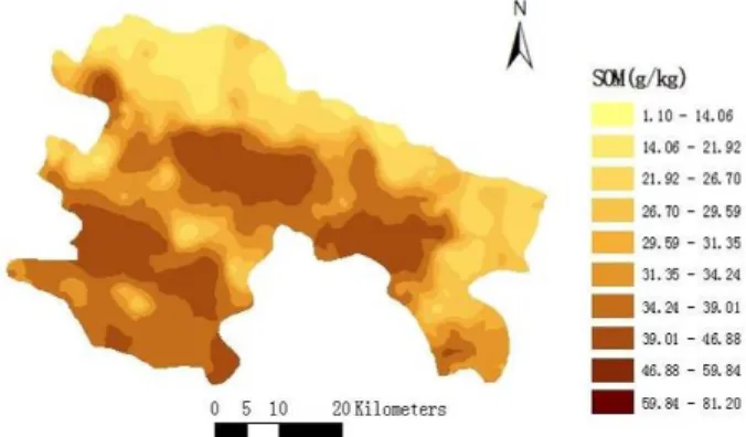
The mean error and the root-mean-square standardized for SOM content were close to 0 and 1, respectively, indicating that the variogram model was accurate and can be used for the kriging method. Kriging accounts for spatial patterns of variation, which can be used to obtain a clear picture of the spatial distribution of SOM content. The process of spatial interpolation involved a search neighborhood with 15 nearest-neighbors. The ordinary kriging predictions were mapped with 5 m × 5 m grid size as shown in Fig. 4. The high content of SOM was distributed in the middle and southwest of Yuanyang county, where the elevation was higher. When the map of SOM distribution was superimposed on the map of
topography, the SOM content in higher elevation was higher than that in lower area. Meanwhile, paddy fields were widely distributed at high altitude (Table 1). Therefore, the spatial distribution of SOM content was generally consistent with the spatial structures of topography and land use patterns, which were basically in agreement with the classical statistics presented above.
DISCUSSION
Effects of topographic factors on SOM content
Topography is one of the major factors affecting the distribution characteristics of SOM content. This study demonstrated that SOM content varied with altitude in Ailao Mountains. The SOM content has been proved to be positively correlated with elevation in Hani terraces, and this result is in agree with previous studies, such as Zhang et al (2007), who studied SOM content in peak-cluster depression areas of Karst Region, and Dai and Huang (2006), who found the SOM content was positively correlated with altitude in the regions of eastern, southern and southwestern of China. However, Cantón et al (2003) showed that the SOM content of gypsiferous materials in Tabernas Desert was negatively correlated with elevation. These contrasted results indicate a possibility that the relationship between SOM content and elevation also depends on the characteristic of landscapes.
The main reasons for the spatial heterogeneity in Hani terraces were as follows: firstly, the ecosystem of Hani terraced fields is composed of ‘forest-village- terrace paddy field-river’ as decreasing of altitude, namely the landscape is comprised of the forest at the hilltop, the stockaded villages below the forest, the
Fig. 4. Spatial distribution of soil organic matter (SOM) content in Yuanyang county, Yunnan Province, China.
terraced fields below the villages and the Honghe water system below the terraced fields. Not only the natural forest, which is helpful for the accumulation of soil organic matter and the conservation of soil and water, but also the farmland adjacent to village, which is convenient for tillage and other agricultural management, resulting in higher SOM content in the top terraced (Wen et al, 2009). Secondly, specific manure management would also be one of the main factors affecting the spatial distribution of SOM content. It was found that SOM content had a distinctive negative correlation with the distance from village with a correlation coefficient of 1.29. This is consistent with the results reported by Cui et al (2010), who found that the local farmers usually manure the farmlands near the village or close to irrigation channels. Because of high and steep mountainous area, the paths from village to farmland were generally too narrow and bumpy to send manure into terraced paddy fields, especially the further terraced fields. Thirdly, the temperature of the area with high elevation was low, which was beneficial for SOM accumulation (Bot and Benites, 2005). Finally, elevation affects the distribution of land use types. For instance, banana and sugarcane, which require a large number of heats, are located below an altitude of 1 100 m, while tea gardens distribute above 1 400 m. The growth of crop under different land use types requires different natural conditions, which may lead to different distributions, and directly resulting in differences of SOM content under different land use types (Xie et al, 2011).
Effects of land use type on SOM content
Changes of land use type can significantly impact SOM content (du Preez et al, 2011). Previous studies showed that the SOM content increased significantly when paddy fields were changed to orchards (Hu et al, 2007), and the soil organic carbon density of paddy fields in hilly regions of south China was lower than that in tea gardens and orchards (Li F B et al, 2012), which was probably due to little or no manure input, low crop intensity and seldom organic material supplement. However, this might not be the truth in some special cases. The mean values of SOM content in paddy fields in karst area and purple hill area are both significantly larger than that in dry land (Li et al, 2009). One possible reason was that cropping under dry land resulted in significant losses of soil organic matter, which was not always the case with cropping under irrigation (du Preez et al, 2011). But the
contents of soil nutrients under different land use types also depended on the characteristics of studied regions, such as climatic, soil condition, and agricultural practice. In this study, the research area has a long history of rice cultivation (Xu et al, 2010), and paddy fields have a high management for sustaining the soil nutrient content and their spatial distribution. Farmers improve soil fertility by plowing, fertilization (manure and chemical fertilizer) and irrigation (Cui et al, 2010). Therefore, the content of SOM in paddy fields is higher than those in other soils from uplands. However, as the penetration of the cash economy, it had become increasingly difficult to continue the traditional agricultural practices that have long sustained the rice terrace agriculture (Adachi, 2007). The crops with high economic value are developed quickly, which might give rise to collapse in some terraces and loss of soil and water. The uplands in Yuanyang county undergone erosion to various degrees, resulting in surface exposure and low amount of organic materials returned to soil. However, paddy fields possess higher SOM content due to greater dry matter production than dry farming land (Liu et al, 2006). These cases remind us that keeping a sustainable development of the terraced rice cultivation must be taken into account immediately.
Paddy field was best for SOM accumulation in Hani terrace fields
The SOM content showed strong spatial heterogeneity based on different land use types. The mean SOM contents in paddy field in the range of 801–1 100 m and 1 101–1 400 m were 31.71 g/kg and 35.87 g/kg, respectively, higher than those in other land use types. Moreover, the SOM content in paddy field at high altitude was even higher than those in other land use types except tea garden and corn field (Table 1). On the whole, paddy field is the best land use type for SOM accumulation in the Hani terraces.
According to Chinese historical materials, Hani terraced paddy fields in Yuanyang county of Southwest China has a history of more than 1 500 years, which is endowed with a special meaning, such as ethical culture, biodiversity, ecological tourist resource and landscape of manmade wetlands. Therefore, terraced paddy cultivation not only has significances to terraced resources protecting and farmland resources sustainable utilization, but also importance for ensuring regional food security and ecological security. These cases remind us to protect paddy fields.
CONCLUSIONS
In the study, case of the Hani terraced fields, the SOM content showed moderate heterogeneity based on the values of the coefficient of variation and the nugget ratios. Elevation and land use type had significant impacts on the spatial variability of SOM content. Soils at higher elevation were seemed to have higher SOM content in comparison with those at lower altitudes. The SOM content in paddy field was 10.83 g/kg, significantly higher than those in other land types except corn field and tea garden, which was mostly located at higher altitudes. The SOM contents in other land use types decreased as follows: paddy field > corn field > banana garden > cassava field. The mean SOM content in paddy field at an altitude of below 1 400 m was 28.28 g/kg, higher than those in other land use types.
Land use management should be enforced for protecting Hani terraced fields. Paddy fields might be an optimal choice for SOM sequestration in Hani terraced fields. In the process of agricultural restructuring, it might be necessary to slow down the pace of agricultural restructuring. Although dry crops might be helpful to increase the income of peasants, it is deleterious for SOM sequestration and environmental protection. Consequently, in order to protect Hani terraced fields and ensure food security in this ecological fragile zone, it is necessary to maintain or even to enlarge the area of paddy fields in Yuanyang county, Yunnan Province, China.
ACKNOWLEDGEMENTS
This work was supported by the National Natural Science Foundation of China (Grant No. 70973143) and Natural Science Foundation of Zhejiang Province, China (Grant No. Y5110259).
REFERENCES
Adachi S. 2007. Agricultural technologies of terraced rice cultivation in the Ailao Mountains, Yunnan, China. Asian Afr
Area Stud, 6: 173–196.
Bai J H, Ouyang H, Deng W, Zhu Y M, Zhang X L, Wang Q G. 2005. Spatial distribution characteristics of organic matter and total nitrogen of marsh soils in river marginal wetlands.
Geoderma, 124: 181–192.
Bot A, Benites J. 2005. The importance of soil organic matter key
to drought-resistant soil and sustained food production. Viale delle Terme di Caracalla, Italy: Food and Agriculture Organization of the United Nations.
Cambardella C A, Moorman T B, Novak J M, Parkin T B, Karlen D L, Turco R F, Konopka A E. 1994. Field-scale variability of soil properties in central Lowa soils. Soil Sci Soc Am J, 58: 1501–1511.
Cantón Y, Solé-Benet A, Lázaro R. 2003. Soil-geomorphology relations in gypsiferous materials of the Tabernas Desert (Almerı´a, SE Spain). Geoderma, 11: 193–222.
Cao S K, Chen K L, Cao G C, Zhang L, Ma J, Yang L, Lu B L, Chen L, Lu H. 2011. The analysis of characteristics and spatial variability for soil organic matter and organic carbon around Qinghai Lake. Procedia Environ Sci, 10: 678–684.
Cheng K, Pan G X, Tian Y G, Li L Q. 2009. Changes in topsoil organic carbon of China’s cropland evidenced from the national soil monitoring network. J Agron Environ Sci, 28: 2476–2481. (in Chinese with English abstract)
Cui B S, Zhao H, Li X, Zhang K J, Ren H L, Bai J H. 2010. Temporal and spatial distribution of soil nutrients in Hani terraced paddy fields, Southwestern China. Procedia Environ Sci, 2: 1032–1042.
Dai W H, Huang Y. 2006. Relation of soil organic matter concentration to climate and altitude in zonal soils of China.
Catena, 65: 87–94.
du Preez C C, van Huyssteen C W, Mnkeni P N S. 2011. Land use and soil organic matter in South Africa: 2. A review on the influence of arable crop production. South Afr J Sci, 107: 358–358.
Duncan D B. 1955. Multiple range and multiple F tests. Biometrics, 11: 1–42.
Fang X, Xue Z J, Li B C, An S S. 2012. Soil organic carbon distribution in relation to land use and its storage in a small watershed of the Loess Plateau, China. Catena, 88: 6–13. Hu K L, Yu Y, Zhang F R, Wang R. 2006. The spatial-temporal
variability of soil organic matter and its influencing factors in suburban area of Beijing. Sci Agric Sin, 39: 764–771. (in Chinese with English abstract)
Hu K L, Li H, Li B G, Huang Y F. 2007. Spatial and temporal patterns of soil organic matter in the urban-rural transition zone of Beijing. Geoderma, 141: 302–310.
Johnston K, ver Jay M H, Krivoruchko K, Lucas N. 2001. Using ArcGIS Geostatistical Analyst. USA: ESRI,St. Charles: 19–203. Li D, Wang Z F, Zhang J B, Gao M. 2009. Contents of soil organic matter, nitrogen, phosphorus and potassium under different land-use patterns in purple hill area. Chin J Soil Sci, 40: 310–314. (in Chinese with English abstract)
Li F B, Lan Y X, Xu C C, Chen H Y, Zhou X Y, Fang F P. 2012. Distribution and effecting factors of soil organic carbon density in terraced fields. J Soil Water Conserv, 26: 179–183. (in Chinese with English abstract)
Li Q Q, Wang C Q, Yue T X, Zhang W J, Yu Y. 2012. Method for spatial simulation of topsoil organic matter in China based on a neural network model. Adv Earth Sci, 27: 175–184. (in Chinese with English abstract)
Li X F, Chen Z B, Chen H B, Chen Z Q. 2011. Spatial distribution of soil nutrients and their response to land use in Eroded area of South China. Procedia Environ Sci, 10: 14–19.
Liu D W, Wang Z M, Zhang B, Song K S, Li X Y, Li J P, Li F, Duan H T. 2006. Spatial distribution of soil organic carbon and analysis of related factors in croplands of the black soil region, Northeast China. Agric Ecosyst Environ, 113: 73–81.
Mabit L, Bernard C. 2010. Spatial distribution and content of soil organic matter in an agricultural field in eastern Canada, as estimated from geostatistical tools. Earth Surf Proc Land, 35: 278–283.
Simón N, Montes F, Díaz-Pinés E, Benavides R, Roig S, Rubio A. 2013. Spatial distribution of the soil organic carbon pool in a Holm oak dehesa in Spain. Plant Soil, 366:537–549.
State Soil Survey Service of China (SSSSC). 1998. China Soil. Beijing: China Agricultural Press. (in Chinese)
Sun B, Zhou S L, Zhao Q G. 2003. Evaluation of spatial and temporal changes of soil quality based on geostatistical analysis in the hill region of subtropical China. Geoderma, 115: 85–89. Wallace C S A, Watts J M, Yool S R. 2000. Characterizing the
spatial structure of vegetation communities in the Mojave Desert using geostatistical techniques. Comput Geosci, 26: 397–410. Wang Q G, Bai J H, Huang L B, Deng W, Xiao R, Zhang K J. 2011.
Soil nutrient distribution in two typical paddy terrace wetlands along the elevation gradient during the fallow period. J
Mountain Sci, 8: 476–483.
Wen B L, Ren G, Zhang N M. 2009. Soil nutrient vertical variance of Hani terraced field in Yuanyang county of Yunnan Province. J
Yunnan Agric Univ, 24: 78–81. (in Chinese with English
abstract)
Xie J, Li Z L, Li Y M, Guo F F. 2011. Evaluation of soil quality under different land use in Naban River watershed, Yunnan
Province of Southwest China. Chin J Appl Ecol, 22: 3169–3176. (in Chinese with English abstract)
Xu H F, Wang Q G, Bai J H, Xiao R, Cao H F, Cui B S. 2010. Changes of phosphate and ammonium nitrogen in irrigated waters of Hani terrace wetlands along the elevation gradients.
Procedia Environ Sci, 2: 1368–1373.
Xu Q, Rui W Y, Liu J L, Liu Z, Yang L, Yin Y J, Zhang W J. 2006. Spatial variation of coupling characteristics of soil carbon and nitrogen in farmland of China. J Ecol Rural Environ, 22: 57–60. (in Chinese with English abstract)
Yang G, Xie Y H, Huang J S, Ren B, Luo W B, Hou Z Y. 2008. A comparative study on spatial distribution characteristics of soil nutrients in natural ecosystems and farmlands in the Dongting Lake area. Res Agric Moder, 2: 213–215. (in Chinese with English abstract)
Zhang C C, Huang R. 1999. Several discussions on constructing high-standard basic farmland in hilly and mountainous areas of China. Probl Agric Econ, 10: 44–47. (in Chinese with English abstract)
Zhang J J, Li F Z, Hu K L, Zhang Q, Guo C X, Huang Y F. 2009. Spatial characteristics and impact factors of soil total nitrogen and soil organic matter in Taiyuan. Acta Ecol Sin, 29: 3163– 3172. (in Chinese with English abstract)
Zhang S W, Huang Y F, Shen C Y, Ye H C, Du Y C. 2012. Spatial prediction of soil organic matter using terrain indices and categorical variables as auxiliary information. Geoderma, 171/172: 35–43.
Zhang W, Chen H S, Wang K L, Su Y R, Zhang J G, Yi A J. 2007. The heterogeneity and its influencing factors of soil nutrients in peak-cluster depression areas of Karst Region. Agric Sci China, 6: 322–329. (in Chinese with English abstract)