1 Uncharted waters: the rise of human-made aquatic environments in the age of the «Anthropocene»
Émilie Saulnier-Talbot & Isabelle Lavoie
Anthropocene 2018
https://doi.org/10.1016/j.ancene.2018.07.003 Abstract
Current anthropogenic global change, including the direct alteration of landscapes and rapid shifts in climate, is having deleterious impacts on existing aquatic resources but is also giving rise to new water bodies. This is affecting the types, area and distribution of continental waters worldwide, and altering global biogeochemical cycles. In addition to the provisions that new aquatic systems can provide, their multiplication and
diversification pose a global challenge regarding their management as aquatic resources and providers of diverse ecosystems services. They also offer opportunities to explore fundamental and applied ecological questions that can lead to a better understanding of ecosystem function in a rapidly changing world. Here, we review the various types of human-made aquatic systems and propose a new term: “anthropohydrocosms”, to designate and contextualize them within the concept of the «Anthropocene». We also develop a classification scheme and briefly discuss the challenge of assessing their importance in providing sustainable ecosystem services.
Keywords: anthropohydrocosm, freshwater, ecosystem services, human impact, water management
2 Highlights:
• Water bodies of human origin have been multiplying throughout the «Anthropocene»
• We propose a new term, “anthropohydrocosm”, to designate this diverse category of water bodies
• Anthropohydrocosms influence the distribution of continental waters worldwide • Anthropohydrocosms play a role in global biogeochemical cycles and provide
ecosystems services
3 Graphical/Visual Abstract and Caption
Caption: Anthropohydrocosms, aquatic systems that owe their inception to deliberate or unintentional human impact, have been multiplying throughout the «Anthropocene».
4 1. Introduction
Globally, the freshwater environment is mutating at an alarming rate due to multiple stressors (Ormerod et al. 2010). Lakes, ponds, and rivers constitute less than 2% of Earth’s non-oceanic area (Downing et al. 2006), but nonetheless, freshwaters represent one of the planet’s richest pools of biodiversity (Dudgeon et al. 2006). Yet, they are also among the most degraded and imperiled ecosystems as they are increasingly under threat from human pressures (Vörösmarty et al. 2010, Carpenter et al. 2011). For example, there has been a staggering 81% decline in freshwater vertebrate populations monitored
between 1970 and 2012 (WWF 2016). Many inland water bodies are currently vanishing due to warmer and drier climate, to mismanagement, or a combination of both (Ravilious, 2016). Worldwide, freshwater availability is changing in response to over-use by humans and anthropogenic climate change, with terrestrial water storage trending below previous ranges (Rodell et al. 2018).
Whereas disappearing surface waters often receive much press coverage because of the catastrophic nature and consequences of these events (see for example, a recent case of “river piracy” in western North America; Shugar et al. 2017), we more seldom hear about cases where aquatic environments are appearing. Although it has been assessed that there has been a net loss of freshwater versus land area across the Earth’s surface over the past 30 years (about 58 000 km2), many regions, most notably South and East Asia and Amazonia, have seen their aquatic area coverage increase (Donchyts et al. 2016). For example, assessment using the Aqua Monitor tool (Donchyts et al. 2016) revealed the appearance of 1180 km2 of water in Myanmar between 1985 and 2010, linked with the
5 construction of dams and reservoirs. Moreover, Lehner et al. (2011) have estimated that about 16.7 million reservoirs larger than 0.01 ha potentially represent an area of
terrestrial surface water of more than 305 000 km2.
Humans have been impacting and modifying existing aquatic systems throughout their history. Early human impacts on continental aquatic systems are temporally and spatially very heterogenous (see Dubois et al. 2017) but impacts that are increasingly global in scope, such as widespread cultural eutrophication, are concurrent with the mid-19th to mid 20th century. Humans have also been creating aquatic systems to accommodate their needs throughout history. The end uses of these anthropogenic aquatic systems are numerous and varied. They include (but are not limited to) water supply, flood control, irrigation, land drainage, hydropower, recreational opportunities, navigational pathways, fisheries and aquaculture. As the global human population has increased at exponential rates, especially since the mid-20th century, so has its need for freshwater and aquatic resources (e.g. Postel et al. 1996). Consequently, the number of human-made aquatic systems has increased accordingly. A prime example of this is the increase in the capacity of large reservoirs built throughout the 20th century (Figure 1).
6 Figure 1. Cumulative nominal volume (capacity) of the world’s largest reservoirs (based on data complied by the International Commission on Large Dams; see also Chao, Wu & Li, 2008; Figure 1). Note that this trend is very similar to the increase of total reservoir storage of dams in the United States (see Figure 3 in Graf, 1999).
Regardless of the boundary that will officially be assigned to the start of the
Anthropocene, this epoch will likely include an exponential increase in human-made aquatic systems, probably following the general trend of the mid-20th century Great Acceleration (Steffen et al. 2015). The effects of this reorganisation of the hydrosphere, which are conceivably multifaceted and highly significant for the whole of the Earth’s functioning, remain relatively unknown. With this review of human-made aquatic systems, our objectives are to (1) bring attention to the importance and diversity of these systems by naming the concept and placing it within a classification scheme and (2) to spark interest in their study and management and invite discussions on the topic within the context of the «Anthropocene».
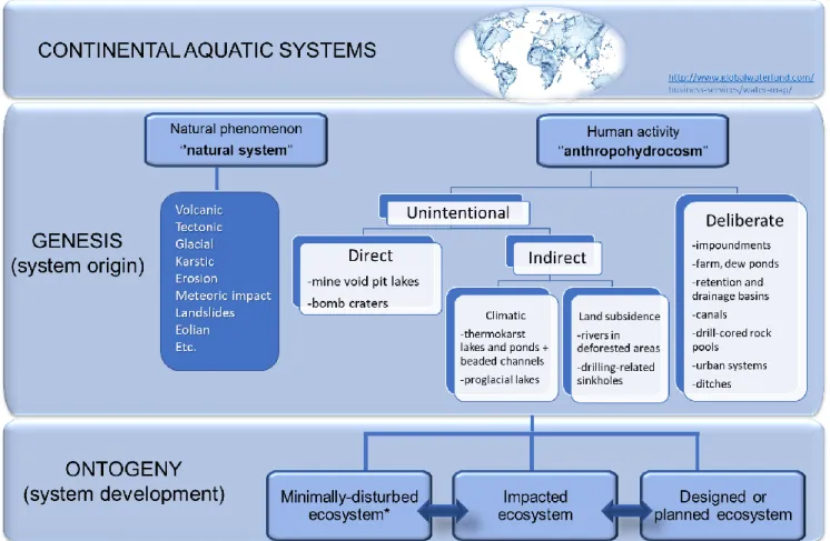
2. Classification of anthropogenic continental aquatic systems based on genesis and ontogeny
Because of the vital services that freshwaters provide, humans have always settled preferentially near rivers, lakes, and wetlands, thereby significantly altering continental aquatic resources throughout history. Anthropogenic modification of all types of continental waters has lead to changes in their distribution, numbers, shapes, sizes, dynamics, physicochemical properties, biodiversity, and functions (e.g. Downing et al. 2006 and Downing 2010 and references therein). Moreover, with an ever-expanding
7 capacity to reshape the environment and to affect global biogeochemical cycles, direct and indirect human activity has been generating new continental aquatic ecosystems at an increasing rate since the mid-20th century (e.g. Graf, 1999; Chao, Wu & Li, 2008).
Aquatic systems of various anthropic origins are a global phenomenon (see Table 1). However, despite their growing numbers, no term exists to refer to them as a
systematically distinct group. As such, we believe that there is a need for an official term, the purpose of which is (1) to refer to this group of systems collectively, and (2) to define them by a specific classification scheme. Here, we put forward a term that endeavors to specifically designate this category of freshwater systems that have come into existence because of direct or indirect human action. We also propose a classification of the various types of human-made freshwater systems. We suggest the term “anthropohydrocosm” to refer to any body of water that was created by human action on the environment. The term anthropohydrocosm is the combination of the Greek anthrop, meaning “human”, hydro meaning “water” and the Latinised Greek cosmos, meaning “world or ordered system”.
The defining characteristic of an anthropohydrocosm is the human origin (genesis) of its physical setting, preceding the establishment and development (ontogeny) of a
functioning ecosystem therein. The need for a term which applies to these systems is further substantiated by the fact that, as a group, even the smallest anthropohydrocosms, by their sheer abundance, can have a large impact on global processes related to
hydrology, climate, sedimentology, geochemistry, and ecology (e.g. Smith et al. 2002; Biggs et al. 2017). Furthermore, the human origin of these systems can have an impact on
8 how they are managed, on the ecosystem services that they provide (see section 5), and on how the general public perceives and values them.
Defining the origin of aquatic systems is, in itself, a useful concept, as has been shown, for example, by the seminal work of Hutchinson (1957), in which lake types are
classified according to their origin. Hutchinson observed that lakes tend to be grouped together in lake districts with a common origin (glacial, tectonic, volcanic, etc.) that unites the different basins. Even though lakes in any given district can differ markedly in size and shape, they resemble each other in certain general characteristics (Hutchinson talked of “diversity in unity”). One of the categories of lakes included in Hutchinson’s classification is anthropogenic (or artificial) lakes. This category differs from the others because human action, as opposed to natural phenomena, is at the origin of the systems and because this type of lake does not necessarily occur in districts. Therefore, some types of anthropogenic lakes will tend to have less in common with the other lakes occurring in their vicinity, such as their age, rate of maturation and senescence. Such differences add to the challenge of understanding their long-term dynamics and
functioning. For example, some reservoirs show a high complexity of outline following the contours of the valleys they occupy, that is unlike most natural lakes (Hutchinson, 1957). This is meaningful because basin morphology (including bathymetry) is a key factor in ecosystem functioning (Wetzel & Likens, 2000). By creating a new term that encompasses all man-made aquatic systems (and not only lakes), we aim to expand and build on the framework of the classification of this type of system.
Classification provides a means for comparing various systems that can contribute to a better understanding of how they function. Figure 2 presents a succinct hierarchical
9 diagram of how we propose to classify anthropohydrocosms within the context of
continental aquatic ecosystems based on genesis and ontogeny. The genesis (origin or coming into being) of an aquatic system can be either natural (i.e. the result of natural phenomena, such as tectonics, volcanism or erosion) or anthropic (i.e. the result of human activity). The human origin of anthropohydrocosms can be either (i) deliberate, i.e. the result of the planned inception of an aquatic system, like canals, polders and reservoirs, or (ii) unintentional, i.e. the human impact that created the physical setting in which the water eventually accumulates, wasn’t initially intended to create an aquatic system, like bomb craters, mine pits, or those that are the result of anthropogenic climatic warming (see Table 1). In this way, we can refer to the former as deliberate anthropohydrocosms, and to the latter as unintentional anthropohydrocosms. Unintentional
anthropohydrocosms can be the result of either direct (such as a bomb crater) or indirect (such as anthropogenically-induced climatic change) human impact on the environment. Although we consider here that climatic anthropohydrocosms (systems that arise from anthropogenically-induced climatic change) are unintentional indirect
anthropohydrocosms, we recognize that this classification can be contentious. In fact, this particular class of systems, which includes new aquatic systems linked to the degradation of the cryosphere (see section 3.2.2.b), could also be considered “iterocosms” – habitats with periods of presence and absence at various temporal scales. We choose to include them as anthropohydrocosms because we argue that, in their current iteration within the context of the «Anthropocene», they have a human origin.
The ontogeny of aquatic systems refers to their physical and biological development or evolution through succession, as ecosystems will become established and transform
10 through time. The state and equilibrium of aquatic ecosystems can depend largely on their history (concept of hysteresis; see Beisner et al. 2003). Consequently, knowing that a system is man-made, and therefore often relatively young, can contribute to a better understanding of how it functions. The following level of the classification of aquatic ecosystems refers to the type of human impact to which they have been subjected through time: (1) minimally disturbed; subjected to little human impact (as totally pristine
ecosystems are now rare; see Catalan et al. 2013), (2) impacted; either unintentionally through indirect or direct human activity, such as through pollution, and (3) designed; deliberately created or changed and redesigned through direct and planned human activity. Designed ecosystems are heavily managed systems in which structure and function are largely the result of intentional human modification. They can include ecosystems that have been restored. In contrast, we use the term "impacted" to denote an ecosystem that is subjected to unintentional anthropic alterations or degradation.
Minimally-disturbed ecosystems are usually located far from human settlements, but can still be subjected to contamination, such as with long-distance atmospheric pollution. Both natural aquatic systems and anthropohydrocosms can fit these three categories. It might appear counter-intuitive that a natural system could be designed, but a system with a natural origin can very well be intentionally modified by humans with a specifically intended design (e.g. dredged rivers). Furthermore, if they are deliberately or
unintentionally impacted through direct anthropogenic stress, natural systems and anthropohydrocosms can in some cases become novel ecosystems, i.e. “ecosystems in which the species composition and/or function have been completely transformed from
11 the historic system” (Hobbs, 2009). They must meet the specific criteria for this
designation, such as those enumerated by Morse et al. (2014).
Providing a unifying term for anthropogenic aquatic systems and placing them into a new classification based on their origin is useful and necessary within an emerging framework for strategic management and conservation of water and aquatic resources in the context of the «Anthropocene». It provides a means by which to better consider the history of a system and improve our understanding of its current state and functioning. We
acknowledge that, at different times of their development, some anthropohydrocosms may be similar to natural systems in various ways and to different degrees, and that their management may not need to differ markedly from nearby natural systems. However, in the early phases of their ontogeny, most anthropohydrocosms will differ significantly from natural systems in their physico-chemical and biotic characteristics (see example in section 3.2.1.a).
The inception of freshwater environments can be attributed to many different
mechanisms, deliberate or not, on the part of humans. The examples presented in the following section serve to demonstrate that anthropohydrocosms contribute in different ways to a life-supporting resource and in many cases, can improve human well-being. However, some can also have various deleterious effects. Here, we review different types of anthropohydrocosms and illustrate them with examples from around the world. We examine them in the context of their potential as providers of ecosystem services (i.e. benefits to humans and their environment) and as vectors of environmental change at various spatial and temporal scales. We also reflect succinctly on the implications of their
12 multiplication for environmental policy making, management of aquatic resources and the development of fundamental environmental knowledge.
Figure 2. Classification of continental aquatic systems according to their origin and ecosystem development. *As some will argue that very few truly pristine ecosystems remain (excluding perhaps some underground or sub-glacial systems), this category includes ecosystems which have been little impacted by direct anthropic activities. An example of this would be aquatic ecosystems in remote locations that are subjected to an amount of long-distance atmospheric deposition pollutants that might have affected certain mechanisms such as primary production, but not species assemblages.
13 3. The hand of humans: anthropogenic environmental modification and the
creation of aquatic ecosystems
Environmental modification by humans resulting in the inception of
anthropohydrocosms, whether it is intentional or not, is present worldwide and in many forms. The physical setting for the appearance of anthropohydrocosms is often rapidly put into place, within a few days to a few years. However, the developmental trajectory towards functioning ecosystems in these spaces can be highly variable and depends on multiple environmental and human factors. The following section presents different examples of anthropohydrocosms, either deliberate or unintentional, illustrated with examples from around the world. This list is by no means exhaustive but is meant to show the diversity of anthropohydrocosms and their impacts on humans and the environment.
3.1 Deliberate anthropohydrocosms: aquatic systems purposefully created by humans to meet a need
3.1.1 Reservoirs and impoundments: trading land for water
Humans have been controlling water to construct reservoirs of all kinds for thousands of years with the aim of storing water for various uses (Lehner et al. 2011; Wohl et al. 2017). As demand for water is predicted to increase drastically by 2050, it is estimated that the area of large impoundments and farm ponds will likely increase annually by 1-2% (Downing et al. 2006). It is also estimated that 48% of the world’s river volume is moderately or severely affected by flow regulation and/or fragmentation; this number is expected to rise to 93% if all planned or proposed dams to be built by 2030 are completed (Grill et al. 2015). Not all reservoirs are aquatic anthropohydrocosms; reservoirs that are
14 natural lakes, where a dam was installed to control water levels, for instance, do not qualify as anthropohydrocosms. We consider reservoirs to be anthropohydrocosms where swaths of land are permanently inundated by an impoundment, creating a new lentic system from what were lotic and terrestrial environments. Reservoirs associated with dams, which transform terrestrial ecosystems into aquatic ones (e.g. Figure 3a), represent a large enough mass of water to affect global climate by altering the global carbon and hydrological cycles (Tranvik et al., 2009). At local to regional scales, they can influence climate and the biota; for example, by creating cooler summers and windier conditions that have a significant impact on tree growth (Tremblay and Bégin 2000), and by
changing the connectivity of freshwaters that can affect species dispersal (e.g. Havel et al. 2005). These constructions serve modern-day needs for power generation, water supply provision and flood control, and also play a key role in aquaculture and agriculture in numerous regions.
Despite the advantages that large reservoirs provide, they can trigger multiple and challenging environmental and societal impacts. One of the most insidious effects of large reservoirs is the emission of methylmercury and greenhouse gas (GHG; especially CH4; see Deemer et al. 2016). Important drawbacks to the construction of dams and reservoirs include: 1) the destruction of land and displacement of human populations (e.g. Three Gorges Dam, China; Jackson and Sleigh 2000), 2) altered water flow potentially affecting downstream biological components all the way into the marine realm (e.g. St. Louis et al. 2000; Hall et al. 2005; Mims and Olden 2013), 3) flow intermittency or drying-up of some rivers (e.g. Colorado River, USA; Flessa et al. 2013), and 4) the increased scarcity of downstream water flow that fuels human conflicts (e.g. Middle East;
15 Barnaby 2009). In fact, it is easy to find examples of rivers (and people who depend on them) that have suffered greatly because of the creation of dams. Nevertheless, negative impacts from the implementation of impoundments can (in part) be abated by better planning, thereby increasing their potential benefits (e.g. Grill et al. 2015).
The different properties and uses of reservoirs around the world imply that they require specific management strategies. Hydroelectric reservoirs built on rivers in thinly populated boreal regions, for example, will not face problems such as overfishing and cultural eutrophication, but may be a source of conflict with autochthonous populations losing access to spiritual or hunting territories. Also controversial are the impoundments that flood arable land, that significantly modify downstream water accessibility or that eliminate important seasonal processes. Such is the case with the damming of the river Nile. The power of the world’s longest river, harnessed in the 1960s for the purpose of generating lower-cost electricity for Egyptians, has been accompanied by both
advantages and disadvantages. The Aswan High Dam effectively altered sediment and nutrient dispersal with consequences for the productivity of downstream ecosystems (Nixon 2003) and put an end to the seasonal flooding along the banks of the Nile, which had been the source of their fertility for thousands of years in this desert environment. However, Lake Nasser, one of the world’s largest artificial lakes, now provides not only hydro-electricity, but is also a reliable water supply and has allowed the development of a multi-species fishery that provides livelihoods for thousands of people (Van Zwieten et al. 2001). Further damming of the Nile, in upstream regions of the Sudan and Ethiopia, remains a source of complex transboundary disputes in the region (Cascão, 2009).
16 An unexpected effect of the implementation of large reservoirs is how it can trigger rapid evolution in some species. A recent study by de Amorim et al. (2017) showed how the creation of isolated islands from formerly connected mountain-tops through the
impoundment of a 170 000-ha area for the creation of a large hydroelectric reservoir in the Cerrado biodiversity hotspot of central Brazil, led to the extirpation (local extinction) of four larger termite-eating lizard species, which in turn freed-up the food-source for smaller termite-eating geckos. Within the space of just 15 years (i.e. since initial flooding in 1997), the geckos on the new islands developed significantly larger heads to
accommodate to newly available larger prey. This rapid adaptive physiological change clearly illustrates how drastic landscape modifications by humans, including the creation of impoundments, can impact the environment at many levels, some unforeseen.
3.1.2 Strength in numbers: small ponds with global significance
The global lake area is dominated by small lakes, both natural and artificial, that roughly outnumber large ones 100:1 (Downing et al., 2006; Céréghino et al., 2008). Even if the volume of water stored in small water bodies (those with an area between 0.1 and 10 km2) is estimated to represent only 2% of the planetary distribution (Messager et al. 2016), their global significance has been largely underestimated. In addition to the regional ecological functions they serve, such as maintaining biodiversity and increasing connectivity between ecosystems, small water bodies contribute significantly to regional and global processes, such as carbon budget, GHG emissions, and biodiversity (Downing 2010; Biggs et al. 2017).
17 Stormwater ponds are increasingly included in urban development planning as best management practices. They serve numerous purposes for the control of runoff flows that may be significant in areas with dense impervious surfaces (Williams et al. 2013). For most people, these small ecosystems are barely noticeable and rarely attract attention. It is when situated in neatly designed parks and made accessible that retention ponds are fully appreciated by the public and can even significantly improve urban life quality. However, these small water bodies are often exposed to strong environmental pressures as they are conceived to receive stormwaters that carry contaminants such as salts, metals and hydrocarbons. Despite their sometimes not so pristine conditions, stormwater
retention ponds (and their associated wetlands in some cases) have the potential to increase local biodiversity. To date, although numerous studies have shown the potential of these systems for increasing and maintaining urban biodiversity and other functions, information is lacking concerning water quality assessment, criteria, and objectives regarding their health. A recent evaluation of Singapore’s ABC waters program (Lim and Lu 2016) provides an example of the kind of assessment of sustainable urban stormwater management that is needed to move forward. Urban stormwater runoff retention provided through low impact development includes the construction of stormwater ponds and wetlands, such as those found in Bishan-Ang Mo Kio, a major park in Singapore. This type of water-sensitive urban design can lead to the development of highly-valued spaces that provide multiple ecosystem services (recreation, tourism, increased biodiversity, reduction of urban heat island effect, etc.).
18 Small rural anthropohydrocosms, such as dew ponds (in the UK), farm ponds and aquatic environments associated with polders (land reclaimed from the sea or other water body) can also be considered individually as small-scale anthropohydrocosms, but collectively may cover substantial areas. In fact, Downing et al. (2006) give a conservative estimate of 77 000 km2 for the area covered by small agricultural ponds worldwide, with annual increase rates that can reach 60% in some regions through pressure to provide food for growing populations. Anthropohydrocosms created for farming purposes tend to be at risk from agricultural intensification and climatic change that could affect certain attributes (such as water quality and sediment in-filling) and require active management for ecosystem services to be maintained. They provide many local ecosystem services, including flood protection (in the case of polders), water for livestock and wildlife (artificial watering holes have been created in some parks and conservation areas, especially in dry climates such as southern Africa), irrigation, and small-scale fish farming. Furthermore, these small ecosystems have the potential to affect biodiversity at much larger scales by providing “stepping stones” for migrating and colonizing species (Erős et al. 2012). In this respect, rural ponds are more than just cisterns.
3.1.2.c Urban and rural wetlands
Wetlands are highly productive ecosystems that play a key role in sustaining biodiversity (Kennedy and Mayer 2002). They absorb the impacts of floods and are efficient natural filters for nutrients and pollutants, making them useful environmental buffers between upland sources within the wider catchment and adjacent ecosystems (Reddy et al 1999). They also have the potential to lower temperature, thereby reducing heat-island effects (Calheiros et al., 2017). However, these unique ecotones have been traditionally
19 perceived as vast wastelands and a large proportion has been drained or filled-in. Even now, many wetlands worldwide are at risk of being wiped-out to
accommodate agriculture or urban developments (Zedler and Kercher 2005). As a small compensation, new wetlands are being created to mitigate the loss of this particularly valuable type of environment (e.g. Giosa et al. 2018). The following examples of constructed wetland success stories show some of the benefits that these
anthropohydrocosms provide in both urban and rural environments.
The very recently created (2016) Woodberry Wetlands are situated in the Inner London borough of Hackney (UK) and cover 4.5 ha. Now a great urban oasis for people to enjoy nature in the heart of a modern metropolis, this anthropohydrocosm traces its origins to the Victorian era when two reservoirs were built to meet the growing demand for drinking water in 19th century suburban London. They are now a hotspot for urban biodiversity and an easily accessible haven for wildlife enthusiasts (Harding and Spencer 2017).
The Réserve naturelle du marais-Léon-Provancher, located approximately 20 km from Québec City (Canada) on the north bank of the St Lawrence River, harbours a recently created wetland in a rural setting (Figure 3b). This 19-ha wetland was built to
accommodate waterfowl on a 125-ha plot of agricultural land where no water was naturally present, except during the snowmelt season. The wetlands and surrounding territory received natural reserve status in 2005 and are well-known for birdwatching.
20 Figure 3 Examples of ‘’direct’’ anthropohydrocosms around the world: a)
Daniel-Johnson (formerly Manic-5) hydroelectric dam impoundment, Rivière Manicouagan, Québec, Canada; b) Réserve naturelle du marais-Léon-Provancher, near Québec City, Canada; c) Canal du Midi, Southern France
(b)
(a)
21 Image credits: a) and b) : photos by first author; c): Le Canal du Midi, paysage d’été (excerpt): oil on canvas, by Gustaf Albert (1866-1905)
3.1.3 Created and resurrected water courses
3. 1.3.a Canals
Canals that were created where no water was previously flowing are, according to our criterion, anthropohydrocosms. Two main types of constructions qualify for this
designation: (1) canals that run parallel or near a natural system and that share its water, and (2) canals created to connect two or more watersheds. Those constructed by dredging a channel at the bottom of an existing water body to facilitate navigation would be better classified as natural designed ecosystems. Ancient purposes for these man-made water courses (water supply, irrigation, transportation) are still relevant today. Proper
management of these anthropohydrocosms is fundamental to preserve their uses by humans, but also for conservation of their biota and riparian environments, some of which have existed for hundreds of years. Many of these constructions now serve recreational and touristic functions and are valued as patrimonial monuments.
One of the best examples of a canal connecting two or more watersheds is the canal du Midi, in southern France (Figure 3c) which dates back to the 17th century. It connects the Garonne River to the Mediterranean Sea, from Toulouse to the Étang de Thau through a 240-km network of navigable waterways. In the mid-19th century, it was linked to the Canal de Garonne, thus joining the Atlantic Ocean (at Bordeaux) to the Mediterranean Sea (together, the two make-up the Canal de Deux Mers). This amazing engineering feat paved the way for the Industrial Revolution and became an indispensable motor for the
22 economy of Southern France, facilitating the transport of goods and people into and out of the region (Mukerji 2009). Although the canal is now mostly used for recreation and tourism, both on the water and on its banks, it also serves as an agricultural reservoir during the dry season, able to irrigate up to 40 000 ha of farmland, and provides drinking water to numerous communes. At this point in its ontogeny, the canal is a self-sustaining ecosystem, valued for the fish and molluscs that are harvested from it and as a highly vegetated area with a diversity of useful tree species growing along its banks. It was designated a UNESCO World Heritage Site in 1996 (Fowler 2002) on the basis that it is an exceptional example of a designed landscape combining technological innovation and a concern for high aesthetics.
3.1.3.b Resurrected rivers
Great potential for new fluvial ecosystems lies six feet under cities, where urbanisation has buried watercourses over time. These inconspicuous former watercourses hidden under layers of concrete are common in large urban centres. For example, it is estimated that about 82% of Montréal’s (Québec, Canada) watercourses have vanished due to urbanisation (Mahaut 2016). These moribund portions of watercourses, connected upstream and/or downstream to natural systems, are now being resurrected and are resurfacing in numerous large cities. When daylighting requires the construction of a new physical stetting, some emerging reaches of watercourses can be regarded as
anthropohydrocosms. However, their pre-existence as natural systems before being lost to culverts and pipes makes the concept of anthropohydrocosms more ambiguous to apply to this type of system. Nevertheless, the fact that a completely new streambed must be excavated and designed to fit with modern urban environments and that colonisation of
23 the newly exposed reach is required to establish a natural community in the newly
exhumed reach justify the use of the term in certain cases.
The practice of creating or ‘’re-creating’’ sections of watercourses comes with numerous advantages: reduced flooding problems due to outdated culverts, decreased run-off which may increase water quality through the filtration of pollutants by riparian vegetation and by reducing nutrient inputs, valuable natural environments for citizens to enjoy, increased value of properties, habitat for biota and improved connectivity along river continuum and between watercourses.
The ambitious Cheonggyecheon Project was implemented to restore the ‘’dead portion’’ of Cheonggyecheon stream in Seoul, South Korea (Lee and Anderson, 2013). This lotic system had been buried under a concrete street in the 1950s when the city decided to “solve” stream issues (in other words, get rid of open sewage). In the 1970s, a freeway was built over this initial street, creating a two-story road. From 2003 to 2005, everything was ripped out and colossal landscaping work followed. The resulting six kilometers of daylighted stream re-introduced nature to this part of the city, promoting a massive 639% increase in overall biodiversity between 2003 and 2008, with bird and insect species increasing from 6 to 36 and from 15 to 192, respectively. Road removal reduced the urban heat island effect, lowering temperatures by 3.3-5.9 degrees Celsius along the stream. This anthropohydrocosm also provides flood protection for up to a once in 200-year event. Moreover, the eco-friendly urban design stimulated the use of public transportation, thus improving air quality by reducing small-particle pollution by 35% (Jang et al. 2010). This sustainable development example also benefitted the economy of the region by boosting property values, commercial development and tourism.
24
3.1.3.c Ditches
Ditches are found globally, mostly in agricultural and wetland-rich regions, but also in forests and urban landscapes. For example, it has been estimated that the United
Kingdom has 600 000 km of permanent and intermittent ditches (Biggs et al. 2017). In spite of low water quality in certain environments, ditches have been found to support important biological diversity and to provide ecosystem services (e.g., Williams et al., 2004; Verdonschot et al. 2011; Fabre-Bac et al. 2016; Biggs et al. 2017). Despite their significance in terms of abundance and the ecological benefits they can provide, these anthropohydrocosms are deemed the “least investigated part of the freshwater
environment” (Biggs et al. 2017).
3.2 Unintentional anthropohydrocosms: where an aquatic system that had not been planned arises following environmental disturbance by humans
3.2.1 Direct modification of the landscape
3.2.1.a Mine void pit lakes
Mine void pit (or strip mine) lakes, as the name entails, are cavities resulting from the excavation of mineral resources that have filled-up with water. In a simplistic way, we can picture these lakes as an often-undesirable industrial legacy metamorphosed into ecologically, economically, aesthetically and scientifically valuable aquatic ecosystems featuring various end-point uses: drinking water supply, recreation, fisheries, irrigation, etc. Each void to be rehabilitated comes with specific challenges. In terms of water quality, the risk of contamination is minimal if inert materials (sand, limestone or gravel) were quarried, but can be more complicated for other types of deposits; for example, gold
25 deposits are often rich in sulphides, or with the presence of radionuclides. In fact, many mine pit lakes are toxic and as such, pose risks to nearby communities and ecosystems, stressing the fact that they must be carefully managed (Blanchette and Lund 2016). The origin of the incoming water (river, rainfall, groundwater) will also influence the chemistry, amount and replenishment (residence time) of the water. The morphology of the basin and proximity to other water bodies are key factors for system functioning and colonization by biota. In Denmark, groundwater-fed gravel pit lakes have added
considerably to the number of high-quality lakes (Søndergaard et al. 2018).
Mine void pit lakes are found in urban and rural areas, as well as in undeveloped areas, far from any human habitation. Those that are near human settlements are increasingly being turned into recreational areas, such as the Lusatian Lakeland. For over 100 years, the Lusatia region of eastern Germany was an important lignite producer and one of the most heavily polluted areas in the country. Now, the region’s former mining pits make-up Europe’s largest artificial lake district, offering a number of recreational activities.
Despite having been filled with ground or river water, many of the lakes were still very acidic in 2005 (pH 2.5-3.5; Kleeberg and Grüneberg 2005). Today, most of the lakes are neutral, and some have been stocked with fish, while others have been put aside for nature conservation (Schultze et al. 2010), indicating that these anthropohydrocosms are developing into ecosystems which support biodiversity worthy of conservation.
The many potential socio-economic and environmental advantages of void pit lakes reflect the feasibility and relevance of carrying-out such rehabilitation projects in urban
26 and rural areas. For example, a study conducted in the late 2000s estimated the annual non-market benefits (ecoservices that don’t directly generate revenue) of the Lusatian lake district at between 10.4 and 16.2 million euros (Lienhoop and Messner 2009). However, there are numerous mine pits in remote regions, where rehabilitation may be more difficult to achieve and less desirable, due in part to less palpable beneficial uses. Even though human populations are less likely to directly benefit from the rehabilitation of mine voids in remote areas, anthropohydrocosms created there could nonetheless be beneficial to biodiversity and perhaps even conservation purposes, such as in arid areas where water is in short supply. They also offer research opportunities to study the development of new ecosystems in a diversity of settings at various spatial and temporal scales.
3.2.1.b Bomb craters
During the 1960-1970s, American military intervention in southeast Asia wreaked havoc on the environment. Spraying of toxic chemicals and herbicides such as Agent Orange and Napalm combined with the dumping of hundreds of thousands of bombs left a legacy of destruction in Laos, which received over 2 million tons of bombs between 1964 and 1973 (Wikes and Allman, 2015). The small craters left behind (10-15 meters in diameter and a few meters deep) subsequently filled with water and became small lakes and ponds. Local inhabitants stocked them with fish and began to practice fish farming, adding protein to their diets and providing them with a way to make a living in some cases. The water from the ponds is also used to irrigate surrounding farmland. The quality of the water has not, to the best of our knowledge, been assessed and it is possible that wartime chemicals could still be present in potentially unsafe levels in some of the lakes, but this
27 remains to be investigated. It therefore appears that these anthropohydrocosms, despite their wicked origin, now offer valuable ecosystem services for local populations.
3.2.2 Indirect modification of the landscape and anthropogenic climate change
3.2.2.a Land subsidence
Land use changes, such as deforestation for agricultural purposes can induce drastic modifications of the landscape. In central Argentina’s San Luis province, a network of new rivers appeared overnight following a storm in 2015
(https://www.theguardian.com/world/2018/apr/01/argentina-new-river-soya-beans). Named Río Nuevo, the watercourses now flow through a maize- and soy-growing region that was originally covered with forests and grasslands. Deforestation decreased the water-absorbing capacity of the unstable soils. This was exacerbated by climate change in the form of wetter conditions over the past few years.
Drilling for various hydrocarbons can weaken ground structure and has been shown to lead to the appearance of sinkholes, for example in Texas (Kim & Lu 2018). These can eventually fill-up with water and become anthropohydrocosms.
3.2.2.b Climate change
The accelerated degradation of the cryosphere due to anthropogenically-induced warming of the climate is producing new aquatic systems, both at high altitudes and latitudes. The types of aquatic systems considered in this section have existed since before humans roamed the Earth, but the fact that in their current iteration, it is human-induced climate
28 change that is now triggering their appearance makes them, in our opinion, unintentional indirect anthropohydrocosms in the context of the «Anthropocene».
Glacial lakes
Melting glaciers are a source of anthropohydrocosms at both high altitudes and latitudes. Indeed, with continued climate warming, current glacial landscapes will likely be
transformed into ones dominated by lakes (Haeberli and Linsbauer 2013). Mountain glaciers are disappearing fast in East Africa (Taylor et al. 2006), the Andes (Bradley et al. 2006) and the Alps (Paul et al. 2004). Shrinking alpine glaciers are also creating
anthropohydrocosms in less conspicuous areas, such as New Zealand (Chinn et al. 2012), where large proglacial lakes such as Lake Tasman (Figure 4a) have formed within the past few decades (Röhl 2008). Receding glaciers and ice-caps expose territory that has been laid bare while uncovering depressions or cavities and leaving behind moraines. These geomorphological features can form basins and can act as barriers for meltwater, creating new lakes. Therefore, some of the meltwater from alpine glaciers is
accumulating in newly formed lakes and is to some degree being retained, although no one knows for how long. Because they are at risk of breaching, causing sudden and intense inundations, new alpine lakes created in this way can sometimes pose a threat to the security of populations living immediately downstream from them (Haeberli et al. 2016). These anthropohydrocosms have the potential to become a source of water and food for local populations and perhaps the deliberate construction of reservoirs to conserve an additional fraction of the alpine meltwater could represent a useful strategy for the future of water availability in these regions. Management must consider how they
29 will be maintained in order to conserve declining meltwater inputs for as long as possible and overseen to avoid catastrophic drainage.
At high latitudes, where human settlements are small and sparse, periglacial
anthropohydrocosms seldom represent hazards. These new lakes and streams have high scientific value because they can be studied to better understand ecological succession, migration and colonization patterns of species and their adaptation to environmental change and variability in a rapidly mutating environment (e.g. Brown et al. 2017). They represent potential habitat for the biota that will be migrating northward with continued warming. Scientific observation of these ecosystems could have important implications for biodiversity conservation. They also represent opportunities to study the physical periglacial environment and how it reacts to climate warming; for example, measuring the rates and the geomorphological effects of permafrost melting that occur beneath these newly formed lakes and wetlands.
Permafrost thaw
A rapidly warming Arctic due to human activities has numerous consequences for the extent and distribution of the hydrosphere. One of the most conspicuous is the
degradation of permafrost in arctic and boreal regions over the last decades, which has simultaneously triggered the appearance of numerous thaw ponds with initial melting, while causing existing lakes to drain, in part or completely, with further degradation (Smith et al. 2005). Substrate permeability is a major factor in determining how these systems will evolve (such as in the case of the aqualysis of boreal patterned fens; White and Payette 2016) and which ones will persist, but Smith et al. (2005) predict that the result will ultimately be a net loss in aquatic ecosystems at high latitudes.
30 Figure 4. Examples of “indirect” anthropohydrocosms around the world: a) proglacial lake Tasman, Aoraki / Mount Cook National Park, Southern Alps, New Zealand; b) permafrost thaw ponds near Umiujaq, Hudson Bay, Northern Québec, Canada; c) beaded stream channels, south of Nuiqsut, Northern Alaska.
(a)
(b)
31 Image credits: a) Photo by first author; b) Photo by I. Laurion (INRS-ETE, used with permission); c) snapshot from Google Earth
Like reservoirs, organically-rich thermokarst lakes and thawing peatlands (Figure 4b) contribute GHG to the atmosphere. These GHGs, dominated by carbon dioxide (CO2) and methane (CH4), are of wide-ranging ages (modern to thousands of years), come from various sources and are emitted at different rates (Bouchard et al. 2015). Higher
temperatures have been shown to significantly increase CH4 and CO2 production and emissions, accompanied by changes in bacterial community composition in small arctic thaw ponds (Negandhi et al. 2014), thereby strengthening several components of the climate feedback loop. As such, thermokarst lakes are of undeniable scientific interest to better understand the dynamics, feedbacks and multi-faceted effects of global change at various spatial and temporal scales.
Beaded stream channels (Figure 4c) are another form of anthropohydrocosm linked to the degradation of permafrost in arctic soils. Because the water in the small pools that make-up these systems tends to remain above 2°C in winter, they may create habitats for fish and other biota (Arp et al. 2015). Although they are frequent in landscapes above 66°N (Arp et al. 2015), beaded stream channels remain little-studied (Tarbeeva and Surkov 2013).
4. Outstanding questions and future avenues for anthropohydrocosm research
Clearly, anthropohydrocosms have the potential to provide humans with a plethora of provisioning, regulating, supporting and cultural services (see Table 1). However, because they can also induce unwanted consequences, they need to be closely planned
32 and managed to ensure that their net effects are positive and that their potential benefits are maximized. For example, net effects of the multiplication of anthropohydrocosms on the global hydrological cycle is a question that needs to be addressed. Large
impoundments (>10 km2) alone are estimated to contain 3% of the global continental water volume and have an average residence time of 5 years (Messager et al. 2016), in effect changing the water cycle pathways and rates of carbon burial in certain regions.
The role of man-made systems at a time when natural systems are increasingly under threat from human pressures is indeed particularly important to assess (e.g. Vörösmarty et al. 2010; Carpenter et al. 2011). The value of anthropohydrocosms can be contextualized within the concept of planetary boundaries (critical processes that regulate Earth System functioning) for estimating a safe operating space for humanity. In the concept of
planetary boundaries, key Earth System processes and boundary levels that should not be transgressed are identified with the objective of avoiding unacceptable global
environmental change (Rockström et al. 2009). For example, the threshold rate at which biological diversity is lost was estimated at <10 extinctions per million species (annual rate). Considering that anthropohydrocosms may affect numerous processes for which planetary boundaries have been established (e.g., climate change, biogeochemical nitrogen and phosphorus cycles, global freshwater use, biological diversity loss; see Rockström et al., 2009), these man-made ecosystems should be included in the equation and appropriately considered. An assessment is needed to determine if and how
anthropohydrocosms play a role in preventing sudden shifts toward contrasting dynamic regimes in aquatic ecosystems. This question deserves in-depth investigation, starting with an estimation of the boundaries for inland water quality and quantity that are needed
33 to maintain aquatic ecosystem services at a safe-operating level. Moreover, the question of how anthropohydrocosms can counteract the disappearance of natural ecosystems must be addressed. In our opinion, anthropohydrocosms have this potential, in many cases. It should also be determined at what point an anthropohydrocosm becomes an “ecologically valuable ecosystem”.
Other research questions that are particularly well-suited to anthropohydrocosms include investigations into rates and patterns of colonisation (succession) by the biota and the development of structure and functions within these aquatic systems. How
anthropohydrocosms can abet environmental risk factors and effects associated with more frequent and stronger extreme climatic events also needs to be better understood, and how, on the other hand, anthropohydrocosms can contribute to aggravating certain effects of global change at various spatial and temporal scales.
Finally, considering the complex mechanisms at work in socio-ecological systems, a better understanding of the trade-offs and synergies in ecosystem services that
anthropohydrocosms create or modify is another question that needs to be addressed. The social and ecological value of anthropohydrocosms could thus be better evaluated and even quantified, allowing for more effective environmental management and increased public awareness (see following section).
5. Valuation of ecosystem services: a price tag on anthropohydrocosms
The goods and services provided by aquatic ecosystems are numerous; from simple esthetics to essential water and food provision. What are the marketable and non-marketable losses related to the destruction of aquatic environments as a result of urban development, farming, or mining, just to name a few? How much money are we willing
34 to invest in the conservation and rehabilitation of aquatic environments, or in the creation of new ones? Putting price tags on ecosystem services is an increasingly popular
approach that is useful, for example, in decision-making (urban development planning, ecosystem restoration, etc.) and could also be applied to certain aspects of the
anthropohydrocosm concept.
Integrating environmental variables into policy-making processes can favor better land development and management (e.g. Hamilton et al., 2015).The idea behind ecosystem valuation, in addition to serving as an influential negotiating tool, is to increase public awareness about the trillions of dollars’ worth of environmental services surrounding us. In this respect, anthropohydrocosms also have a non-negligible economic value, despite the fact that natural ecosystems have often been lost in the first place. Different methods used for ecosystem valuation and the actual exercise of pricing the monetary value of anthropohydrocosms could realistically be carried-out.
Ecological benefits are often broadly categorized into provisioning,
regulating, supporting, and cultural services in accordance with the definition in
the Millennium Ecosystem Assessment (2005; but see US EPA document from Landers and Nahlik (2013) for a more refined definition). For the purpose of this paper, the concept is simply and briefly represented using a general example of some “valuable” ecosystem services provided by a theoretical storm water retention pond located in an urban setting (Figure 5). Ecological valuation may also extend beyond the physical limits of an ecosystem, as benefits cascade to nearby environments. For example, it is unlikely that an urban retention pond will be used for provisioning drinking water or stocked with
35 fish. However, the water quality of nearby receiving natural environments such as natural rivers may be considerably improved by reduced urban runoff, resulting in decreased costs for water treatment, and increased water quality leading to better health and biodiversity in the downstream systems. Along the same line, a functional aquatic ecosystem, even man-made, can provide habitat that may favour pollinators of urban gardens. This latter service is, however, more difficult to value in terms of dollar units and is much less tangible compared to the money saved by cities on water treatment costs or pricy after-flood reconstruction, for example.
36 Figure 5. Examples of goods, services and functions provided by a hypothetical
stormwater retention pond. Benefits not only profit the urban setting where the pond is located, but also the nearby receiving ecosystem.
Ultimately, anthropohydrocosms can provide much the same ecosystem services as natural systems. However, because anthropohydrocosms are often in the early stages of their ontogeny, managing and conserving them in an informed way requires taking into account the fact that their evolutionary trajectories could diverge considerably and unpredictably from those that are anticipated. This is especially to be expected in cases where management is minimal or absent.
Conclusion
Anthropohydrocosms constitute one of the most important human impacts on our planet. They are often the result of activities and disturbances that are at some level questionable or that can have adverse effects on one or more components of the environment or of society but can in time come to represent a valuable resource providing ecosystem services. The need exisits to more closely study and manage all aspects related to them.
In the context of environmental research, management and conservation,
anthropohydrocosms can be useful in expanding our understanding of fundamental ecological processes such as ontogeny and succession and could also serve as
experimental systems to test new ecological theories and to carry out novel management protocols. Moreover, the ecological knowledge gleaned from observations of these new ecosystems over relevant timescales could have direct applications for refining and
37 improving the management and conservation of natural ecosystems and resources in a wide variety of settings.
Because of their non-natural origin, anthropohydrocosms might be considered of lesser value than their natural counterparts. This review shows that these “artificial” systems have the potential to provide valuable ecosystems services. By having a specific term with which to refer to them as a group, and by placing them within a classification, we hope to bring more attention to this type of system and contribute to their improved integration into the ecological, conservation and management literature.
This work did not receive any specific grant from funding agencies in the public, commercial, or not-for-profit sectors.
38 References
Arp, C.D., Whitman, M.S., Jones, B.M., Grosse, G., Gaglioti, B.V., Heim, K.C., 2015. Distribution and biophysical processes of beaded streams in Arctic permafrost
landscapes. Biogeosci 12, 29-47.
Barnaby, W., 2009. Do nations go to war over water? Nature 458, 282-283.
Beisner, B.E., Haydon, D.T., Cuddington, K., 2003. Alternative stable states in ecology. Front Ecol Environ 1, 376-382.
Biggs, J., Von Fumetti, S., Kelly-Quinn, M., 2017. The importance of small waterbodies for biodiversity and ecosystem services: implications for policy makers. Hydrobiol 793, 121-133.
Blanchette, M.L., Lund, M.A., 2016. Pit lakes are a global legacy of mining: an
integrated approach to achieving sustainable ecosystems and value for communities. Curr Opin Env Sust 23, 28-34.
Bouchard, F., Laurion, I., Prėskienis, V., Fortier, D., Xu, X., Whiticar, M.J., 2015. Modern to millennium-old greenhouse gases emitted from ponds and lakes of the Eastern Canadian Arctic (Bylot Island, Nunavut). Biogeosci 12, 7279−7298.
Bradley, R.S., Vuille, M., Diaz, H.F., Vergara, W., 2006. Threats to water supplies in the tropical Andes. Science 312, 1755−6.
Brown, L.E., Khamis, K., Wilkes, M., Blaen, P., Brittain, J.E., Carrivick, J.L, Fell, S., Friberg, N., Füreder, N., Gislason, G.M., Hainie, S., Hannah, D.M., James, W.H.M., Lencioni, V., Olafsson, J.S., Robinson, C.T., Saltveit, S.J., Thompson, C., Milner, A.M., 2017. Functional diversity and community assembly of river invertebrates show globally
39 consistent responses to decreasing glacier cover. Nature Eco Evo 2, 325-333. DOI:
10.1038/s41559-017-0426-x.
Calheiros, C.S.C., Barreira, E., Ramos, N.M.M., Castro, P.M.L. 2017.Water masses surface temperatures assessment and their effect on surrounding environment. Water Sci Tech 75, 2916-2925. DOI: 10.2166/WST.2017.146.
Carpenter, S.R., Stanley, E.H., Vander Zanden, M.J., 2011. State of the world’s
freshwater ecosystems: physical, chemical and biological changes. Ann Rev Environ Res 36, 75-99.
Cascão, A.E. 2009. Changing power relations in the Nile river basin: Unilateralism vs. cooperation? Water Alternatives 2(2): 245‐268.
Catalan, J., Pla-Rabés, S., Wolfe, A.P., Smol, J.P., Rühland, K., Anderson, J.N.,
Kopáček, J. Stuchlink, E., Schmidt, R., Koinig, K., Camarero, L., Flower, R.J., Heiri, O., Kamenik, C., Korhola, A., Leavitt, P.R., Psenner, R., Renberg. I. 2013. Global change revealed by palaeolimnological records from remote lakes: A review. J Paleolim 49: 513– 535.
Céréghino, R., Biggs, J., Oertli, B., Declerck, S. 2008. The ecology of European ponds: defining the characteristics of a neglected freshwater habitat. Hydrobiol 597, 1-6. Chao, B.F., Wu, Y.H., Li, S., 2008. Impact of artificial reservoir water impoundment on global sea-level. Science 320, 212-214.
40 Chinn, T., Fitzharris, B.B., Willsman, A., Salinger, M.J. 2012. Annual ice volume
changes 1976-2008 for the New Zealand Southern Alps. Global and Planetary Change 92-93, 105-118. doi:10.1016/j.gloplacha.2012.04.002.
Dearing, J.A., Yang, X., Dong, X., Zhang, E., Chen, X., Langdon, P.G., Zhang, K., Zhang, W., Dawson, T.P., 2012. Extending the timescale and range of ecosystem services through paleoenvironmental analyses, exemplified in the lower Yangtze basin. P Natl Acad Sci USA 109:E1111-20.
Deemer, B.R., Harrison, J.A., Li, S., Beaulieu, J.J., Delsontro, T., Barros, N., Bezerra-Neto, J.F., Powers, S.M., Dos Santos, M.A., Vonk, A., 2016. Greenhouse gas emissions from reservoir water surfaces: a new global synthesis. BioSci 66, 949-964.
de Amorim, M.E., Schoener, T.W., Santoro, G.R.C.C., Lins, A.C.R., Piovia-Scott, J., Brandão, R.A., 2017. Lizards on newly created islands independently and rapidly adapt in morphology and diet. P Natl Acad Sci USA 114, 8812-8816.
Donchyts, G., Baart, F., Winsemius, H., Gorelick, N., Kwadijk, J., van de Giessen, N., 2016. Earth’s surface water change over the past 30 years. Nat Clim Chang 6, 810−813. Downing, J.A., 2010. Emerging global role of small lakes and ponds: little things mean a lot. Limnetica 29, 9−24.
Downing, J.A., Prairie, Y.T., Cole, J.J., Duarte, C.M., Tranvik, L.J., Striegl, R.G., McDowell, W.H., Kortelainen, P., Caraco, N.F., Melack, J.M., Middelburg, J.J., 2006. The global abundance and size distribution of lakes, ponds, and impoundments. Limnol Oceanogr 51, 2388−2397.
41 Dubois, N., Saulnier-Talbot, É., Mills, K., Gell, P., Battarbee, R., Bennion, H., Chawchai, S., Dong, X., Francus, P., Flower, R., Gomez, D.F., Gregory-Eaves, I., Humane, S., Kattel, G., Jenny, J.-P., Langdon, P., Massaferro, J., McGowan, S., Mikomägi, A., Nguyen, T.M.N., Sandaruwan Ratnayake, A., Reid, M., Rose, N., Saros, J., Schillereff, D., Tolotti, M., Valero-Garcés, B., 2017 First human impacts and responses of aquatic systems: a review of paleolimnological records from around the world. Anthropoc Rev 5, 28-68. doi/10.1177/2053019617740365.
Dudgeon, D., Arthington, A.H., Gessner, M.O., Kawabata, Z.I., Knowler, D.J., Lévêque, C., Naiman, R.J., Prieur-Richard, A.H., Soto, D., Stiassny, M.L., Sullivan, C.A., 2006. Freshwater biodiversity: importance, threats, status and conservation challenges. Biol Rev 81, 163−82.
Erős, T., Olden, J.D., Schick, R.S., Schmera, D. and Fortin, M.J., 2012. Characterizing connectivity relationships in freshwaters using patch-based graphs. Landscape Ecol 27, 303-317.
Evans, A.J., Firth, L.B., Hawkins, S.J., Morris, E.S., Gouge, H., Moore, P.J., 2015. Drill-cored rock pools: an effective method of ecological enhancement on artificial structures. Mar Freshwater Res 67, 123-130.
Favre-Bac, L., Mony, C., Ernoult, A., Burel, F., Arnaud, F.-F., 2016. Ditch network sustains functional connectivity and influences patterns of gene flow in an intensive agricultural landscape. Hered 116, 200-212.
42 Flessa, K.W., Glenn, E.P., Hinojosa‐Huerta, O., Parra‐Rentería, C.A., Ramírez‐
Hernández, J., Schmidt, J.C., Zamora‐Arroyo, F.A., 2013. Flooding the Colorado River Delta: A Landscape‐Scale Experiment. Eos, Trans Am Geophys Union 94, 485-486. Fowler, P., 2002. World Heritage Cultural Landscapes, 1992-2002: a review and
prospect. In: Cultural landscapes: The challenges of conservation; World Heritage Papers 7, UNSECO World Heritage Center. 189 pp.
Giosa E., Mammides C., Zotos, S., 2018. The importance of artificial wetlands for birds: A case study from Cyprus. PLoS ONE 13(5): e0197286. https://doi.org/10.1371/journal. pone.0197286.
Graf, W.L., 1999. Dam nation: A geographic census of American dams and their large-scale hydrological impacts. Wat Resour Res 35, 1305-1311.
Grill, G., Lehner, B., Lumsdon, A.E., MacDonald, G.K., Zarfl, C., Reidy Liermann, C., 2015. An index-based framework for assessing patters and trends in river fragmentation and flow regulation by global dams at multiple scales. Environ Res Let 10, 015001. doi: 10.1088/1748-9326/10/1/015001.
Haeberli, W., Linsbauer, A., 2013. Global glacier volumes and sea level – small but systematic effects of ice below the surface of the ocean and of new local lakes on land. Cryosphere 7, 817-821.
Haeberli, W., Buetler, M., Huggel, C., Friedli, T.L., Schaub, Y., Schleiss, A.J., 2016. New lakes in deglaciating high-mountain regions–opportunities and risks. Clim Change 139, 201−214.
43 Hall, B.D., St. Louis, V.L., Rolfhus, K.R., Bodaly, R.A., Beaty, K.G., Peterson, M.J., Cherewyk, K.P., 2005. Impacts of reservoir creation on the biogeochemical cycle of methyl mercury and total mercury in boreal upland forests. Ecosystems 8, 248-266.
Hamilton, P.H., Lavoie, I., Alpay, S., Ponader, K., 2015. Using diatom assemblages and sulphur in sediments to uncover the effects of historical mining on Lake Arnoux (Quebec, Canada): A retrospective of economic benefits versus environmental debt. Front Ecol Evol 3, article 99.
Harding, M.J., and Spencer, K.S., 2017. What Has The Heritage Lottery Fund Done For Nature? Report by Hummingbird/OHES for the Heritage Lottery Fund, London. 111pp.
Havel, J.E., Eunmi Lee, C., Vander Zanden, J., 2005. Do reservoirs facilitate invasions into landscapes? Biosci 55, 518-525.
Hobbs, R.J., Higgs, E., Harris. J.A., 2009. Novel ecosystems: implications for conservation and restoration. Trends Ecol Evol 24, 599-605.
Hutchinson, G.E., 1957. A treatise on limnology. Geography, physics, and chemistry; (Part 1) Geography and physics of lakes. New York: Wiley, 540 pp.
Jackson, S., Sleigh, A., 2000. Resettlement for China’s Three Gorges Dam: socio-economic impact and institutional tensions. Communist Post-Commun 33, 223-241.
Jang, Y.-K., Kim, J., Kim, H.-J., Kim, W.-S. 2010. Analysis of Air Quality Change of Cheonggyecheon Area by Restoration Project. J Env Impact Assessment 19, 9-106.
Kennedy, G., Mayer, T., 2002. Natural and constructed wetlands in Canada: An overview. Water Qual Res J Can 37, 295-325.
44 Kim, J.W., Lu, Z., 2018. Association between localized geohazards in West Texas and human activities, recognized by Sentinel A-1/B satellite radar imagery. Sci Rep 8, article number 4727. doi:10.1038/s41598-018-23143-6.
Kleeberg, A., Grüneberg, B., 2005. Phosphorus mobility in sediments of acid mining lakes, Lusatia, Germany. Ecol Eng 24, 89-100.
Landers, D.H., Nahlik, A.M., 2013. Final Ecosystem Goods and Services Classification System (FEGS-CS). EPA/600/R-13/ORD-004914. U.S. Environmental Protection Agency, Office of Research and Development, Washington, D.C.
Lee, J.Y., Anderson, C.D., 2013. The Restored Cheonggyecheon and the Quality of Life in Seoul. J Urb Technol 20, 3-22.
Lehner, B., Reidy Liermann, C., Carmen, R., Vörösmarty, C., Fekete, B., Crouzet, B., Döll, P., Endejan, M., Frenken, K., Magome, J., Nilsson, C., Robertson, J.C., Rödel, R., Sindorf, N., Wisser, D., 2011. High-resolution mapping of the world’s reservoirs and dams for sustainable river-flow management. Front Ecol Env 9, 494-502.
Lienhoop, N., Messner, F., 2009. The economic value of allocating water to post-mining lakes in East Germany. Water Resour Manag 23, 965-980.
Lim, H.S., Lu, X.X., 2016. Sustainable urban stormwater management in the tropics: An evaluation of Singapore’s ABC Waters Program. J Hydrol 538, 842-862.
Mahaut, V. 2016. User's guide to the cartographic data of the island of Montreal's former watercourses, thalwegs, and watersheds (In French). Faculté de l’aménagement, Université de Montréal. 11 pp.
45 Messager, M.L., Lehner, B., Grill, G., Nedeva, I., Schmitt, O., 2016. Estimating the volume and age of water stored in global lakes using a geostatistical approach. Nat Comms 7, article number 13603.
Millennium Ecosystem Assessment 2005. Ecosystems and Human Well-being: Synthesis. Island Press, Washington, DC.
Mims, M.C., Olden, J.D., 2013. Fish assemblages respond to altered flow regimes via ecological filtering of life history strategies. Freshwat Biol 58, 50-62.
Morse, N.B., Pellissier, P.A., Cianciola, E.N., Brereton, R., Sullivan, M., Shonka, N., Wheeler, T., McDowell, W., 2014. Novel ecosystems in the «Anthropocene»: a revision of the novel ecosystem concept for pragmatic applications. Ecol Soc 19:12.
Mukerji, C., 2009. Impossible engineering: technology and territoriality on the Canal du Midi. Princeton University Press.
Negandhi, K., Laurion, I., Lovejoy, C., 2014. Bacterial communities and greenhouse gas emissions of shallow ponds in the High Arctic. Polar Biol 37, 1669−1683.
Nixon, S.W., 2003. Replacing the Nile: are anthropogenic nutrients providing the fertility once brought to the Mediterranean by a great river? AMBIO 32, 30-39.
Ormerod, S.J., Dobson, M., Hildrew, A.G., Townsend, C.R., 2010. Multiple stressors in freshwater ecosystems. Freshwat Biol 55, 1−4.
Paul, F., Kääb, A., Maisch, M., Kellenberger, T., Haeberli, W., 2004. Rapid
46 Postel, S.L., Daily, G.C., Ehrlich, P.R. 1996. Human appropriation of renewable fresh water. Science 271, 785-788.
Ravilious, K., 2016. Many of the world’s lakes are vanishing and some may be gone forever. New Scientist, Daily News, 4 March 2016;
https://www.newscientist.com/article/2079562-many-of-worlds-lakes-are-vanishing-and-some-may-be-gone-forever/
Reddy, K.R., Kadlec, R.H., Flaig, E., Gale, P.M., 1999. Phosphorus retention in streams and wetlands: a review. Crit Rev Env Sci Tech 29, 83-146.
Rodell, M., Famiglietti, J.S., Wiese, D.N., Reager, J.T., Beaudoing, H.K., Landerer, F.W., Lo, M.-H. 2018. Emerging trends in global freshwater availability. Nature 557, 651-659. doi:10.1038/s41586-018-0123-1.
Rockström, J., Steffen, W., Noone, K., Persson, Å., Chapin III, F.S., Lambin, E., Lenton, T.M., Scheffer, M., Folke, C., Schellnhuber, H., Nykvist, B., De Wit, C.A., Hughes, T., van der Leeuw, S., Rodhe, H., Sörlin, S., Snyder, P.K., Costanza, R., Svedin, U., Falkenmark, M., Karlberg, L., Corell, R.W., Fabry, V.J., Hansen, J., Walker, B., Liverman, D., Richardson, K., Crutzen, P., Foley, J., 2009. Planetary boundaries: exploring the safe operating space for humanity. Ecol Soc 14, 32.
http://www.ecologyandsociety.org/vol14/iss2/art32/
Röhl, K., 2008. Characteristics and evolution of supraglacial ponds on debris-covered Tasman Glacier, New Zealand. J Glaciology 54, 867-880.
47 Schultze, M., Pokrandt, K.H., Hille, W., 2010. Pit lakes of the Central German lignite mining district: Creation, morphometry and water quality aspects. Limnologica 40, 148-155.
Shugar, D.H., Clague, J.J., Best, J.L., Schoof, C., Willis, M.J., Copland, L., Roe, G.H., 2017. River piracy and drainage basin reorganization led by climate-driven glacier retreat. Nat Geosci 10, 370-375.
Smith, S.V., Renwick, W.H., Bartley, J.D., Buddemeier, R.W., 2002. Distribution and significance of small, artificial water bodies across the United States landscape. Sci Tot Env 299, 21-36.
Smith, L.C., Sheng, Y., MacDonald, G.M., Hinzman, L.D., 2005. Disappearing arctic lakes. Science 308, 1429−1429.
Søndergaard, M., Lauridsen, T.L., Johansson, L.S., Jeppesen, E., 2018. Gravel pit lakes in Denmark: chemical and biological state. Sci Tot Env 612, 9-17.
St. Louis, V.L., Kelly, C.A., Duchemin, E., Rudd, J.W., Rosenberg, G.M., 2000.
Reservoir surfaces as sources of greenhouse gases to the atmosphere: A global estimate. Biosci 50, 766−775.
Steffen, W., Broadgate, W., Deutsch, L., Gaffney, O., Ludwig, C., 2015. The trajectory of the Anthropocene: The Great Acceleration. Anthropoc Rev 2, 81-98.
Tarbeeva, A.M., Surkov, V.V., 2013. Beaded channels of small rivers in permafrost zones. Geogr Nat Res 34, 216-220.