HAL Id: hal-01949323
https://hal.archives-ouvertes.fr/hal-01949323
Submitted on 10 Dec 2018
HAL is a multi-disciplinary open access archive for the deposit and dissemination of sci-entific research documents, whether they are pub-lished or not. The documents may come from teaching and research institutions in France or abroad, or from public or private research centers.
L’archive ouverte pluridisciplinaire HAL, est destinée au dépôt et à la diffusion de documents scientifiques de niveau recherche, publiés ou non, émanant des établissements d’enseignement et de recherche français ou étrangers, des laboratoires publics ou privés.
Distributed under a Creative Commons Attribution - NonCommercial - NoDerivatives| 4.0
OMERE: A Long-Term Observatory of Soil and Water
Resources, in Interaction with Agricultural and Land
Management in Mediterranean Hilly Catchments
Jérôme Molenat, Damien Raclot, Rim Zitouna, Patrick Andrieux, Guillaume
Coulouma, D. Feurer, Olivier Grünberger, Jean-Marie Lamachère,
Jean-Stéphane Bailly, Jean-Luc Belotti, et al.
To cite this version:
Jérôme Molenat, Damien Raclot, Rim Zitouna, Patrick Andrieux, Guillaume Coulouma, et al.. OMERE: A Long-Term Observatory of Soil and Water Resources, in Interaction with Agricultural and Land Management in Mediterranean Hilly Catchments. Vadose Zone Journal, Soil science society of America - Geological society of America., 2018, 17 (1), �10.2136/vzj2018.04.0086�. �hal-01949323�
OMERE: A Long-Term Observatory of Soil
and Water Resources, in Interaction with
Agricultural and Land Management in
Mediterranean Hilly Catchments
J. Molénat,* D. Raclot, R. Zitouna, P. Andrieux, G. Coulouma,
D. Feurer, O. Grunberger, J.M. Lamachère, J.S. Bailly,
J.L. Belotti, K. Ben Azzez, N. Ben Mechlia, M. Ben Younès
Louati, A. Biarnès, Y. Blanca, D. Carrière, H. Chaabane,
C. Dagès, A. Debabria, A. Dubreuil, J.C. Fabre, D. Fages,
C. Floure, F. Garnier, C. Geniez, C. Gomez, R. Hamdi, O.
Huttel, F. Jacob, Z. Jenhaoui, P. Lagacherie, Y. Le Bissonnais,
R. Louati, X. Louchart, I. Mekki, R. Moussa, S. Negro, Y. Pépin,
L. Prévot, A. Samouelian, J.L. Seidel, G. Trotoux, S. Troiano,
F. Vinatier, P. Zante, J. Zrelli, J. Albergel, and M. Voltz
To account for the diversity of agricultural and ecosystem situations in hilly Mediterranean areas, the agro-hydrological observatory OMERE (Observatoire Méditerranéen de l’Environnement Rural et de l’Eau) monitors two farmed catchments—one in northern Tunisia and the other in southern France. Mediterranean regions are typified by a highly variable climate, with an alter-nation of long droughts and intense storms, and by a strong heterogeneity of soil properties, due to a combination of climate, relief, parent materials, sparse vegetation, intense land use, man-made infrastructure (ditches, terraces, etc.), and agricultural activities. In this context, OMERE aims to document the impacts of agricultural and land management on mass fluxes in Mediterranean farmed headwater catchments. The observation strategy is motivated by monitoring water, sediment, and contaminant fluxes and hydrologic and climatic variables at different spatial scales from cultivated plots and landscape elements to the catchment scale. These measurements have been performed at a fine time reso-lution over a long-term scale and by surveying land use, agricultural practices, and soil surface characteristics. The long-term observation strategy intends to support integrative multidisciplinary research for elucidating the conditions that improve soil and water management and delivery of ecosystem services in a Mediterranean rainfed cultivated context. The observatory has led to scientific insights regarding three scientific objectives: (i) to better understand the fluxes of water, erosion, and contaminants, especially pesticides, and of their natural and anthropogenic drivers on short- and long-term scales; (ii) to analyze the aggre-gate effects of farming and land management on mass fluxes across scales, from plot to catchment or landscape scales; and (iii) to derive new scenarios for sus-tainable agricultural management and improved delivery of ecosystem services.
Abbreviations: ERT, electrical resistivity tomography; ET, evapotranspiration; OMERE, Observatoire Médi-terranéen de l’Environnement Rural et de l’Eau; SASW, spectral analysis of surface waves; Vis-NIR, visible– near-infrared.
The Mediterranean region
is one of the areas in the world that is a hotspot for climate change and, more generally, for global change. Climate change projections pre-dict a significant decrease in winter precipitation and an increase in rainstorms and torrential rains (IPCC, 2014). It is also expected that the population will largely increase from 370 million in 2000 to an estimated 560 million in 2030 (Ludwig et al., 2010). Natural resources and agriculture will be put under large pressure, while there is alreadyCore Ideas
• OMERE is a Mediterranean observatory of two farmed catchments in Tunisia and France.
• Water, contaminant, and erosion fluxes are monitored from plot to catchment scales.
• Soils and land use in relation with agriculture are surveyed.
• Scientific results concern elementary processes and integrated catchment functioning.
• Models were conceived for evaluation of land use and agricultural manage-ment scenarios.
J. Molénat, D. Raclot, G. Coulouma, D. Feurer, O. Grunberger, J.M. Lamachère, J.S. Bailly, J.L. Belotti, K. Ben Azzez, A. Biarnès, Y. Blanca, D. Carrière, C. Dagès, A. Dubreuil, J.C. Fabre, D. Fages, C. Floure, F. Garnier, C. Geniez, C. Gomez, R. Hamdi, O. Huttel, F. Jacob, Z. Jenhaoui, P. Lagacherie, Y. Le Bissonnais, R. Moussa, S. Negro, Y. Pépin, L. Prévot, A. Samoue-lian, G. Trotoux, S. Troiano, F. Vinatier, P. Zante, J. Albergel, and M. Voltz, LISAH, Univ. Montpellier, INRA, IRD, SupAgro, Montpellier, France; R. Zitouna, R. Louati, I. Mekki, and J. Zrelli, INRGREF, Carthage Univ., Tunis, Tunisia; P. Andrieux, ASTRO, INRA, Guadeloupe, France; K. Ben Azzez, M. Ben You-nès Louati, R. Hamdi, and Z. Jenhaoui, IRD, Tunis, Tunisia; N. Ben Mechlia and H. Chaabane, INAT, Car-thage Univ., Tunis, Tunisia; A. Debabria, DG-ACTA, Ministry of Agriculture, Tunis, Tunisia; X. Louchart, Envilys, Villeneuve-les-Maguelone, France; J.L. Seidel, HydroSciences Montpellier, Univ. Montpel-lier, CNRS, IRD, MontpelMontpel-lier, France. J. Albergel and M. Voltz are founders of the OMERE observatory. D. Raclot, R. Zitouna, J. Molénat and P. Andrieux are past or current coordinators of the OMERE observatory. D. Raclot, R. Zitouna, P. Andrieux, G. Coulouma, D. Feurer, O. Grunberger, and J.M. Lamachère are past or current site managers of the OMERE observatory. *Corresponding author (jerome.molenat@inra.fr).
Received 22 Apr. 2018. Accepted 9 Aug. 2018.
Citation: Molénat, J., D. Raclot, R. Zitouna, P. Andrieux, G. Coulouma, D. Feurer, O. Grunberger, J.M. Lamachère, J.S. Bailly, J.L. Belotti, K. Ben Azzez, N. Ben Mechlia, M. Ben Younès Louati, A. Biarnès, Y. Blanca, D. Carrière, H. Chaabane, C. Dagès, A. Deba-bria, A. Dubreuil, J.C. Fabre, D. Fages, C. Floure, F. Garnier, C. Geniez, C. Gomez, R. Hamdi, O. Huttel, F. Jacob, Z. Jenhaoui, P. Lagacherie, Y. Le Bissonnais, R. Louati, X. Louchart, I. Mekki, R. Moussa, S. Negro, Y. Pépin, L. Prévot, A. Samouelian, J.L. Seidel, G. Trotoux, S. Troiano, F. Vinatier, P. Zante, J. Zrelli, J. Albergel, and M. Voltz. 2018. OMERE, a long-term observatory of soil and water resources, in inte-raction with agricultural and land management in Mediterranean hilly catchments. Vadose Zone J. 17:180086. doi:10.2136/vzj2018.04.0086
Special Section: Hydrological Observatories
© Soil Science Society of America.
This is an open access article distributed under the CC BY-NC-ND license
(http://creativecommons.org/licenses/by-nc-nd/4.0/).
a shortage of these resources and in agricultural production in this area. Arable land is scarce, which leads to the expansion of intensive agriculture in several countries, whether irrigated or rain-fed, toward marginal land that can degrade when too intensively exploited (MediTERRA, 2008). Water resources are basically lim-ited in most Mediterranean ecosystems, given the chronic deficit between rainfall and potential evapotranspiration (ET) and the long drought periods. Water withdrawals for crop irrigation cur-rently amount to a very large proportion of the annual renewable water resources in many Mediterranean countries (Milano et al., 2013). Consequently, the present trends may lead to severe and irreversible environmental damages and, thus, to large social ten-sions within and between Mediterranean countries.
In this context, long-term observation of the fate of soil and water resources is essential to understanding key processes under-way and their interaction with agricultural and land management to better assess the main environmental risks and identify the mitigation levers. It is on these premises that we set up OMERE, a long-term agro-hydrological observatory, situated in the hilly areas of the Mediterranean region, in 2002 (Voltz and Albergel, 2002). The name OMERE is an acronym for Mediterranean Observatory
of Rural Environment and Water (Observatoire Méditerranéen de l’Environnement Rural et de l’Eau, in French). It was part of an initiative of the French Ministry of Research that launched a call for funding Environmental Research Observatories (French acronym ORE, for Observatoire de Recherche en Environnement) to provide high-quality observational data for studying the func-tioning of continental systems and their long-term dynamics. The observatory OMERE filled the lack of long-term environmental observatories in the Mediterranean region. To illustrate this point, one can note that at the landscape or regional scales, only five Mediterranean agricultural observatories are registered on the Long-Term Ecosystem Research sites map (https://data.lter-europe. net/deims/site/list), two of them being the OMERE observatory. To take into account the diversity of agricultural and eco-system situations in the hilly Mediterranean areas, OMERE monitors two farmed catchments—one in Cap Bon Peninsula in Tunisia, and the other in the south of France. Both sites have been monitored since the 1990s and represent two typi-cal Mediterranean land uses, namely, (i) the combination of cereal crops and rangelands and (ii) vineyard monoculture. The OMERE observatory is co-managed by five research insti-tutes: Institut National de la Recherche Agronomique (INRA), Institut de Recherche pour le Développement (IRD), and Centre National de la Recherche Scientifique (CNRS) in France, and Institut National Agronomique de Tunisie (INAT) and Institut National du Génie Rural, des Eaux et Forets (INRGREF) in Tunisia. In 2011, OMERE took part in the creation of the French network of drainage basins, Réseau des Bassins Versants (RBV, http://portailrbv.sedoo.fr/), and now the Observatoire de la Zone Critique, Applications et Recherches (OZCAR) infrastructure for observing the critical zone for the long term (Gaillardet et al., 2018). Furthermore, OMERE has taken part in international
research initiatives such as the Surfaces et Interfaces Continentales en Méditerranée (SICMED) project (Voltz et al., 2018) and the Soil Transformations in European Catchments (SoiLTrEC) proj-ect (Menon et al., 2014).
Here, we describe the motivation and science questions that support the monitoring efforts of OMERE and present the char-acteristics and monitoring design of both OMERE sites, as well as an overview of the obtained results. Today, 20 yr of results provide very positive scientific paybacks. Finally, some lessons and perspec-tives that emerged, in our opinion, from the long-term monitoring experience are emphasized.
6
Motivation and Science Questions
In addition to the environmental challenges described above, Mediterranean landscapes exhibit strong intrinsic specifications that make them a suitable model for studying global change effects. A major characteristic of Mediterranean landscapes is that they are the fruit of millennia of anthropogenic cultivation. Therefore, they are an example of intensive land management that has often shaped the landscapes through digging ditches, build-ing hilly reservoirs, formbuild-ing terraces for preventbuild-ing or limitbuild-ing water erosion and surface runoff, or intensive farming practices that exploited almost every piece of land. Moreover, they offer a diversity of situations for comparison. Today, for example, strong social dynamics imply the coexistence of agricultural intensifica-tion in favorable places with agricultural decline in marginal lands (de Franchis and Ibanez, 2003; García-Ruiz et al., 2013). Both OMERE sites include such diversity.
The characteristics of Mediterranean climate, namely, its chronic deficit of water, long periods of drought, very large inter-annual variations, and high frequency of intense, sometimes devastating, storms, may also be seen as an experimental model for many temperate countries that will experience climate change. Examining strategies developed by Mediterranean ecosystems and farmers to adapt to this highly variable climate may offer very useful lessons for mitigating climate change.
Eventually, Mediterranean soils that result from a unique com-bination of climate, relief, heterogeneous parent materials, sparse vegetation, and intense land use also add to the exemplary character of the Mediterranean area. Soils are organized in a complex pattern across short distances, often associating uphill shallow and skeletal soils with downhill deep soils, formed from a colluvium of eroded material. They are generally poor in organic matter and prone to erosion. With the predicted increase in temperature, droughts, and intense storms, it is expected that soil losses may accelerate, and soil C stocks may be depleted (Lagacherie et al., 2018). The overall vulnerability of Mediterranean soils and their high spatial variabil-ity is thus an opportunvariabil-ity for evaluating sustainable management practices, both at the plot and landscape scale.
In this context, OMERE observatory aims to document the impact of agricultural and land management on mass fluxes in typical farmed headwater catchments of the Mediterranean region.
Its long-term observation strategy intends to support integrative multidisciplinary research for elucidating the conditions for improved soil and water management and delivery of ecosystem services. Accordingly, the researchers that take advantage of the facilities provided by OMERE address a large number of scien-tific issues that can be grouped according to three broad objectives. We describe these objectives below and how they lead to specific research questions, in relation to the particular characteristics and processes of the Mediterranean farmed areas.
A first objective is to estimate the fluxes of water, erosion, and contaminants and to identify their natural and anthro-pogenic drivers on short- and long-term scales. This very basic objective, common to most hydrological observatories, requires, in the case of OMERE, the tackling of specific research questions related to the particular characteristics and processes that occur in Mediterranean hydrosystems. Among them are the study of (i) the influence of uneven and intense runoff events and of long periods of drought on the hydrological cycle and on the dynamics of soil and water contamination by pesticides; (ii) the spatiotemporal variations in infiltration and runoff partitioning and in erosion in relation to soil types and soil tillage; and (iii) the influence of slopes and of row cropping, such as in vineyards and orchards, on ET fluxes.
A second objective is to elucidate the aggregate effects of farm-ing and land management on the mass fluxes across scales, from plot to catchment or landscape scales. It is expected that these effects are very significant in regard to the general fate of soil and water resources, and in turn, good management may mitigate the negative effects of global change. Accordingly, the influence of many natural or man-made features is studied at OMERE. Among them are soil tillage, plot and catchment water harvesting tech-niques, ditch networks, and terraces that all correspond to typical management activities in Mediterranean farmed areas.
A third objective is to derive new scenarios for a sustainable agricultural management and improved delivery of ecosystem services by Mediterranean farmed landscapes (e.g., agricultural biomass production, water production, erosion prevention, flood regulation, and water contamination regulation). For this aim, spatially distributed modeling approaches for simulating water, sediment, and contaminant fluxes at plot and catchment scales are developed and evaluated. They benefit from large, long-term moni-toring datasets and detailed processes analysis, prone to facilitate model design, calibration, and validation. Moreover, basic knowl-edge and multi-decadal time series observations sustain applied research, dedicated to diagnostic tools for agro-environmental engineering of cultivated landscapes.
Motivation of OMERE goes largely beyond its strict scientific interests. Equipped sites offer very good support for educational purposes and capacity building. Each year, many students and professionals in hydrology, agronomy, soil sciences, and related topics visit the sites, become familiar with monitoring tech-niques, observed processes, and farming systems, or have tutorials in the field. Moreover, since OMERE is binational, it enhances
cooperation between the northern and southern shores of the Mediterranean Sea and helps to build some pieces of common culture and understanding, which is valuable in the present times.
6
Catchment Characteristics
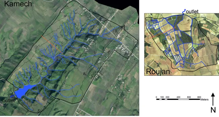
The experimental catchments are located on both sides of the Mediterranean Sea. The Roujan catchment is 60 km west of Montpellier (43°30¢ N, 3°19¢ E) in the south of France, and the Kamech catchment (36°87¢ N, 10°87¢ E) is located within the Cap Bon Peninsula in the north of Tunisia (Fig. 1). The main fea-tures of both catchments are given in Table 1. The climate is rather similar for the two sites. Kamech and Roujan are characterized by a similar annual rainfall (25-yr means of 645 and 628 mm for Kamech and Roujan, respectively), unevenly distributed through-out the year. The major rainfall occurs in spring and autumn for the French site, whereas the end of spring and the summer are sys-tematically dry periods for the Tunisian site. The mean maximal temperature is the same at both sites (?15°C in January and 30°C in July to August). However, the minimal temperature is different; it is always 5°C lower in Roujan and without frost days in Kamech. The two catchments present typical Mediterranean hydrological responses (Fig. 2), with annual stream runoff depending mainly on annual rainfall and with the occurrence of extreme runoff events (a maximum annual specific runoff of 520 mm observed in Roujan in 1996). The annual reference ET (ET0) is 1109 and 1366 mm in Roujan and Kamech, respectively. Every year, the two catchments are characterized by a threshold cumulative rainfall of ?450 mm, before marked stream runoff starts. This large rainfall threshold can be explained by the ET that leads to soil drying from spring to fall, by rainfall infiltration due to topsoil cracks at the end of the summer in Kamech, and by runoff infiltration through ditch bottoms, due the dense network of ditches in Roujan.
The substratum of the two catchments belongs mainly to the Miocene marine deposits (Fig. 3). However, the nature is differ-ent. In Roujan, the calcareous loose sandstone with centimetric laminations and intercalations of loamy clay material is covered by lacustrine limestone, which constitutes the bedrock of the catchment. In Kamech, the bedrock corresponds to the slightly calcareous laminated mudstone, with intercalations of hard sandstone. The soil along the hillslopes is directly developed over and from the Miocene deposits and is representative of the main Mediterranean soils (European Soil Data Centre, 2014). The soil depends on the nature of the deposits and on the position within the slope. The main difference is observed in the highly clayed soils in Kamech and calcareous silty soils in Roujan (Table 1). Following International Union of Soil Sciences classification, soils are Cambisols, Regosols, and Calcsols in both catchments, with the addition of Vertisols in Kamech (IUSS Working Group WRB, 2014). The soil depends mainly on the slope. Along the hillslope, soil depth increases from upslope to downslope, with changes in soil texture in relation to the colluvial deposits. Temporary and permanent shallow groundwaters are present along the hillslopes
and in the bottom lands of the two catchments. The unweath-ered mudstone in Kamech (between 2 and 6 m deep) and the deep loamy clay marine deposits in Roujan (between 4 and 7 m deep) constitute the lower bed of shallow groundwater.
More than 80% of the catchment area is covered by crop-lands. There are sharp contrasts in landscape between the steep slope areas with human terraces or rangelands (i.e., west to east for Roujan, and northwest to southeast for Kamech) and the rest of the catchment, especially the glacis in the Roujan catchment.
The gentle slopes are covered mostly by vineyards in Roujan, with some orchards in the bottom lands. Remaining parts are covered by shrubs and low trees. Kamech is mainly covered by cereals and leguminous crops. Remaining parts are covered by
Fig. 1. Locations of Roujan and Kamech experimental catchments.
Table 1. Main features of the Observatoire Méditerranéen de l’Environnement Rural et de l’Eau (OMERE) catchments.
Property Roujan Kamech
Area, km2 0.92 2.63
Slope (quartiles), % 0, 3, 6, 11, 30 0, 6, 11, 18, 30
Clay content (range), % 5–37 12–67
Pebbles (range), % 0–58 0–16
Soil calcium carbonate (range), g kg−1 4–479 2–199 Soil organic matter (range), % 0.4–2.6 0.3–2.0 Soil thickness (range), m 0–4.5 0–2.5
Land use vineyards and
cereals cereals, legumes, and degraded rangeland
Fig. 2. Relationship between annual rainfall and annual stream runoff in the two sites. The period ranges from 1993 to 2015 in Roujan and from 1995 to 2013 in Kamech (adapted from Voltz et al., 2016).
degraded rangelands and dwellings. Agricultural practices are dif-ferent between Roujan and Kamech. Intensive viticulture in the Languedoc area has tended to decrease with lower production since the middle of the past century, whereas the use of mechanization and chemicals has been increasing in Kamech.
The two sites have been dedicated to agriculture for several thousand years and currently present anthropogenic features aiming to control runoff, to decrease erosion damages, and to preserve soils and water (Fig. 4). There are >10 km of ditches in Roujan, around the vineyard fields. A dam was built at the Kamech outlet in 1994 for reducing downstream siltation and for water harvesting. These anthropogenic features highly affect the hydro-logical behavior of both catchments.
6
Basic Long-Term Observations
Observation Strategy
To meet its objective of observing hydrological processes related to agricultural activities in hilly rural Mediterranean areas, OMERE developed an observation strategy, allow-ing for the high spatial and temporal variabilities of different
observed variables to be considered. As we aimed to study how farming and land management at local scales control water and soil resources, the observation infrastructure was designed to monitor fluxes at nested scales, from the plot (i.e., the farm field) to the catch-ment scales (Fig. 5). More generally, most observations are recorded through a network of sensors, which allows the description of the spatial heterogeneities within the catchments. Table 2 details the hydrometeorological variables monitored in both OMERE sites.
In accordance with the high temporal variability of hydrological and meteorological processes in the Mediterranean region, the observations are performed at high frequency— typically 5-min intervals or shorter. As the observatory is dedicated to the study of land cover and agricultural practices as drivers of soil and water resources, surveys of land cover and agricultural practices are also a key element of the observation strategy.
Meteorological Data
Eleven daily-read cumulative rain gauges and four automatic tipping-bucket rain gauges were installed to monitor rainfall intensity and its spatial pattern. Automatic rain gauges provide instantaneous data. Quality control is performed by comparing
Fig. 3. Geological cross-sections of the main hillslope of the two catchments. The main soils are described according to the World Reference Base clas-sification (IUSS Working Group WRB, 2014).
daily reads of cumulative rain gauges and cumulative daily records with automatic rain gauges. Rainfall has been monitored since 1992 in Roujan and 1994 in Kamech.
A weather station records the following atmospheric parameters at each site: air temperature and humidity, wind speed and direc-tion at 2 m above ground level, and global radiadirec-tion at 1 m above ground level. In addition, free water evaporation is measured on a
daily basis on the Tunisian test site, with a sunken Colorado 1-m2
evaporation pan.
Surface Water
Water levels in the hydrographic network are measured with hydrometric stations. The stations are placed strategically to obtain water flow data for studying the scale effects from field to
Fig. 4. Aerial maps of Roujan and Kamech catchments (same scale). The catchment boundaries are depicted by thick black lines, the elevation curves are thin black lines, and the drainage system, including a small reservoir in the Kamech catchment, is drawn with blue lines. The thin red lines correspond to the geological cross-sections of Fig. 3.
Fig. 5. The Observatoire Méditerranéen de l’Environnement Rural et de l’Eau (OMERE) hydrometeorological monitoring infrastructure (see details in Table 2). The different surface colors indicate the subcatchments delineated from hydrometric stations. In the Roujan catchment, the drainage system contains mainly anthropogenic ditches, fed by surface runoff. In the Kamech catchment, the drainage system contains mainly a natural wadi network.
catchment scales, as well as to understand the impacts of the land-scape and soil structures on water flow, such as gullies in Kamech and ditches in Roujan. In total, a network of hydrometric stations (five in Kamech and seven in Roujan) equipped with flumes were installed. Water levels in Venturi or U-shaped concrete flumes are continuously recorded, as well as water electrical conductivity. For that purpose, a flat V-weir was built in hydrometric stations with U-shaped flumes. Stage-discharge curves were obtained with field surveys for a large range of discharges.
Groundwater
The water table is measured through piezometer networks, which were designed to describe spatial and temporal variabili-ties of the water table and to understand groundwater–stream exchanges. The piezometers are equipped with automatic pressure sensors, recording water level and temperature at sub-hourly time steps. Depending on the catchments, one to four piezometers are equipped with an automatic water electrical conductivity sensor. Manual measurements of the water level
Table 2. Recorded hydrometeorological variables and sensors used at Observatoire Méditerranéen de l’Environnement Rural et de l’Eau (OMERE) sites.
Variables
Scale
Measured since
Acquisition Field plot/
distributed Hillslope/network Catchment Sensors Automatic or manual (frequency)† Meteorology
Rainfall (intensity) X X X 1992R/1994K‡ 400-cm2 0.5-mm tipping-bucket Précis Mécanique rain gauges A (instantaneous) Rainfall (total) X X X 1992R/1994K 400-cm2 Précis Mécanique and Hydreka rain gauges M (daily) Rainwater chemistry X X 2004R/2016K CIMEL rain sampler and manual sampling A (event) and M
(daily)
Wind speed X 1992R/1999K A100RK (Vector) and CIMEL-CE155R anemometers A (30K and 60 minR daily)
Wind direction X 1992R/1999K W200PK (Vector) and CES157R (Cimel) wind vanes Air temperature and
humidity X 1992
R/1999K HMP45K (Vaisala) and CES185-191R (Cimel) thermohygrometers
Global radiation X 1992R/1999K SP1110K (Skye) and CMP6R (Kipp & Zonen) pyranometers
EvaporationK XK 1995K sunken Colorado pan M (daily)
Land surface fluxes Actual
evapotranspiration X 2005
R/2010K CSATK (Campbell) and 81000R (Young) three-dimensional
sonic anemometers, Li7500 (LI-COR) H2O/CO2 analyzers A (30–60 min) Surface water fluxes
Discharge (water level) X X X 1993R/1994K CS451 (Campbell) and ELSYDE SPI pressure sensor, SEROSI
nilometer A (1 min)
Sediment load X X X 1994R/2004K OBS500 turbidimeter (Campbell), SD900P 24-bottle samplers (Sigma) and homemade cumulative sampler, manual sampling during floods
A and M (5 min, event)
Sediment budgetK XK 1994K field surveyed Kamech’s lake bathymetry M (biennial)
Major cations and
anions X X X 1994
R/2009K SD900P 24-bottle samplers (Sigma) and manual sampling A and M (event) Pesticides X X X 1997R/2017K SD900P 24-bottle samplers (Sigma), manual sampling A and M (1-min,
event) Groundwater
Water table level and
temperature X X 1993
R/2007K pressure sensor (Keller & Druck, Diver, US 517, LevelTroll) A (5 minK, 60 minR)
X X 1992R/2007K manual measures M (weekly)
Groundwater
conductivity X X 2004
R/2007K CTD (Diver) A and M (event)
Major cations and
anions X X 2004
R/2007K SD900P 24-bottle samplers (Sigma), manual sampling M (event) Soil moisture
Water content XR XR 2005R neutron probes M (monthly)
XR 2014R SoilNet network with SPADE (Sceme) soil moisture sensors A (30 min) † A, automatic acquisition; M, manual acquisition.
are performed monthly to check for and correct potential pres-sure sensor drifts.
Soil Moisture
In the Roujan catchment, nine neutron probe access tubes were installed in 2004 to monitor soil moisture in the rooting zone, mostly in vineyards. They were installed in the vicinity of existing piezometers to obtain deep water content profiles. The accessible depths vary between 2.2 and 3.8 m, depending on tube locations, and measurements are performed at 0.2- to 0.4-m depth increments. Measurements are performed approximately every month, with the frequency varying according to rainfall events. To obtain a higher time resolution, a SoilNet wireless network (Bogena et al., 2010) of five soil moisture profiles was installed in 2014. Each profile includes six temperature and soil moisture sensors (ring oscillators) located at approximate depths of 0.1, 0.3, 0.6, 1.0, 1.5, and 2.0 m. Data are collected and transmitted every 30 min. In Kamech, soil moisture has been measured less continuously; the main campaigns were conducted in 1999–2000 and 2012–2013, with a neutron probe or from gravimetric samples (Mekki et al., 2018).
Land Surface Fluxes
Eddy covariance techniques are routinely used to measure fluxes between surface and atmosphere, mainly the latent heat flux or ET. Similar flux towers were installed near the centers of the Roujan and Kamech catchments in 2005 and 2010, respectively. Both towers are equipped with fast response (20 Hz) sensors, a three-dimensional sonic anemometer and an open-path H2O/CO2 analyzer. They differ by the height of the sensors, which are 6.2 and 9.6 m above ground level for Roujan and Kamech, respectively, leading to a smaller average footprint (12 ha) in Roujan than in Kamech (19 ha). The sensible and latent heat fluxes are routinely calculated hourly, quality checked using standard tests, and then aggregated at a daily time step after the gap-filling of missing or rejected data to obtain continuous chronicles of ET.
Water Chemistry and Contaminants
For each runoff event occurring at both sites, samples of water are collected, using either automatic 24-bottle samplers or cumulated automatic samplers, in each of the hydrometric stations. Additionally, the electrical conductivity and the major anions and
cations are analyzed.
The dynamics of pesticides, mainly herbicides, have been monitored since the beginning of the observatory, using the nested network of hydrometric stations in Roujan. The monitoring is based on the knowledge of the applied treatments that are recorded at the two sites. Since 1994, samples of surface waters have been collected during each runoff event at the catchment outlet and on a vineyard plot, for which the applications of pesticides are pre-cisely known. A network of perforated and buried bottles near the piezometers allows stratified sampling of groundwater at given depths, ranging from 0.5 to 5 m. The depth intervals between the bottles are ?1 m. Furthermore, soil samples are also collected for
chemical analysis on some vineyard plots. The number and type of molecules of pesticides and metabolites researched and analyzed have varied over time, depending on their use by farmers.
Erosion
Suspended sediment concentration is monitored for each runoff event using dedicated water samplers or the water samples collected for water chemistry. The water samples are first dried or filtered and then weighed to derive sediment concentrations in the runoff. In the downstream hydrometric station of each catchment, a continuous measurement of turbidity was added a few years ago to better capture the high-frequency dynamics of sediment fluxes. In Kamech, regular bathymetric surveys are performed to assess changes in the volume of sediment trapped in the outlet reservoir and to derive an erosion rate at the catchment scale (see Raclot and Albergel, 2006, for more explanation). All of these devices enable the evaluation of sediment fluxes and the establishment of a sediment budget at different timescales at the nested monitor-ing stations in the two catchments. Note that some analyses of pesticides, C and N nutrients, and metallic trace elements are also performed on the sediments (particulate phase) in a selection of runoff water samples.
Land Use, Agricultural Practices,
and Soil Surface Characteristics
Because of their strong impact on runoff, erosion, and con-tamination by pesticides, a major effort is put into documenting land use, agricultural practices, and the resulting soil surface char-acteristics. Specific field surveys are dedicated to the monitoring of land use on all the plots of both catchments. Field surveys, con-ducted approximately once per month, permit the monitoring of visible agricultural practices, such as soil tillage, whereas farmer surveys allow for the documentation of other practices, mainly dates of application and types of pesticides used. Because of their strong effect on the infiltration rate and runoff generation, the soil surface characteristics are also observed during the field sur-veys, following the method proposed by Andrieux et al. (2001). Furthermore, other anthropogenic activities, such as water releases from the outlet reservoir in Kamech or maintenance of ditches in Roujan, are also recorded.
6
Dedicated Campaigns
and Experiments
Numerous campaigns and short- and long-term experiments have been conducted within both catchments in relation to the scientific questions of the OMERE observatory, namely, the analy-sis of the high spatiotemporal variations of infiltration and runoff partitioning in relation to the spatial variations of soil properties and to the spatiotemporal variations of soil treatments. They mainly aimed (i) to determine permanent properties and (ii) to monitor, with high frequency and/or high spatial resolution, one or more variables of state or temporally variable properties. At
the beginning of the observatory, most surveys were conducted to understand the hydrological dynamics of the two catchments (e.g., infiltration of the soil surface in Leonard and Andrieux, 1998; aquifer systems and geochemistry in Bouzigues et al., 1997, and Tassinari et al., 2002; stream sources in Ribolzi et al., 2000; hydro-logical behavior in Moussa et al., 2002; and erosion flux in Albergel et al., 2003). As long-term hydrological monitoring equipment is described in the section above, we focus here on geophysical and remote sensing campaigns dedicated to soil properties or mapping of soil surface properties. In addition, a third part traces the evolu-tion of the monitoring of ET flows, according to the development of new methodologies and new issues that we addressed.
Dedicated Geophysical Survey Campaigns
for Soil Property Mapping
The use of indirect methods, such as geophysical surveys, to explore underground is necessary to avoid destructive and expen-sive drilling. Three types of techniques have been used in the observatory: (i) the self-potential signal to monitor groundwater levels and their variations, for which the observatory was a pilot site for methodological development (Revil et al., 2002; Suski et al., 2006; Linde et al., 2007); (ii) the electrical resistivity tomogra-phy (ERT); and (iii) the spectral analysis of surface waves (SASW). The last two techniques are used for bedrock mapping, which is a mandatory prerogative for each long-term observatory. In the lithologic and pedological context of the observatory, no conven-tional geophysical bedrock mapping method has been shown to be effective, due to the combination of uphill shallow and skeletal soils with downhill deep soils typical of Mediterranean head catch-ments and of a shallow water table. Spectral surface wave analysis and high-resolution classical ERT in wet and dry conditions were combined to map the bedrock depth of the Roujan catchment. The map was built from eight transects across the catchment and 81 drill holes, to calibrate geophysical measurements (Coulouma et al., 2012). The observatory databases were also used to compare three conventional geophysical approaches—dry ERT, diachronic ERT, and SASW—for mapping bedrock depth (Coulouma et al., 2013).
Dedicated Remote Sensing Campaigns
for Soil Surface Property Mapping
Remote sensing surveys have been widely used in the obser-vatory. The objective was to map permanent or variable soil properties involved in water, sediment, and contaminant transfers. The development of new methods and their applications constitute a major challenge, given the great spatial and temporal variability of soil properties and the variability of the transfers induced by agricultural activities and by the Mediterranean climate. On 2 Nov. 2010, a visible–near infrared (Vis-NIR, 0.4–2.5 mm) hyperspec-tral AisaDUAL image was acquired by plane across a study area (12 ´ 25 km) including the Kamech catchment. As an emblem-atic example, the evaluation of the soil property prediction and spatialization based on Vis-NIR hyperspectral airborne data was performed (Gomez et al., 2012). The interest of combining a field
soil survey, airborne campaign, and simulated satellite data for the prediction of soil clay content at different spatial resolutions was also evaluated, providing maps of surface clay content from 5- to 30-m spatial resolution (Gomez et al., 2015).
With respect to time-varying properties, preliminary work has been conducted to map the soil surface characteristics, such as soil plant cover and soil crust (Wassenaar et al., 2005; Corbane et al., 2008a, 2008b, 2012). More recently, we have studied the ability of aerial photography with low-tech kites to obtain a decimeter digital elevation model. Aerial photography, with simple but appropriate equipment, has proven to be an alternative tool for surveying gul-lies with submetric details across the Kamech catchment (Feurer et al., 2018). Indeed, a decimetric-resolution digital elevation model of 3.18-km2 area was constructed, with a mean error and a standard
error in elevation of +7 and +22 cm, respectively.
Dedicated Campaigns for Evapotranspiration
Fluxes: Technological Evolution
Several experimental campaigns have been devoted to the evaluation of the actual ET at various spatial scales, from field-scale to mesofield-scale catchments (?100 km2). At the field scale,
Trambouze et al. (1998) monitored different components of ET in a vineyard—soil evaporation and plant transpiration were mea-sured using microlysimeters and sap-flows devices, respectively, and compared with Bowen-ratio ET measurements. Using eddy covariance measurements, Zitouna-Chebbi (2009) conducted sev-eral campaigns to characterize the evolution of ET for the main crops in the Kamech catchment. At the headwater catchment scale, Hébrard et al. (2006) analyzed spatial and temporal variability of surface soil moisture. Bsaibes (2007) and Zitouna-Chebbi (2009) used large aperture scintillometers to investigate flux tower eddy covariance measurements. At the mesoscale of the Peyne catch-ment (that includes the Roujan site), time series of thermal infrared images (taken with the Advanced Spaceborne Thermal Emission and Reflection Radiometer [ASTER] instrument aboard the Terra satellite) were used to evaluate remote sensing methods of ET retrieving across vineyards (Galleguillos et al., 2011a, 2011b).
6
Data Management and Policy
The long-term observations acquired in OMERE are all preprocessed and implemented in a dedicated PostgreSQL database called HYSAE, an acronym standing for HYdrologie Spatialisée-Agrosystème-Environnement (spatial hydrology-agrosystems-environment). The OMERE observatory has set up a quality assurance procedure based on the drafting of protocols that trace the data and their preprocessing from field acquisition to stor-age in the HYSAE database and backup on a remote datacenter. The applied preprocessing information is also stored in the data-base and can be retrieved with the dataset. The HYSAE datadata-base is coupled to a spatial data infrastructure, based on the GeOrchestra OpenSource solution, which mobilizes Geoserver for the manage-ment of Web Map/Web Feature Service flows and Geonetwork
for the metadata catalog. The OMERE spatial data infrastructure enables easy rendering and user-friendly cartographic querying of data, accessible via the internet (http://www.obs-omere.org/). Specific developments have also been made for the online visu-alization of time series. The observatory’s long-term monitoring has been specially set up for and dedicated to online data access. Basic monitoring data are accessible without any embargo time, whereas additional data, including data acquired within a spe-cific research project (e.g., a third-party-funded Ph.D. study), are accessible after a maximum embargo time of 5 yr. Some sensitive personal data (e.g., pesticides) or data acquired by third parties are not disseminated, in compliance with the information technol-ogy and freedom regulations that guarantee the confidentiality of personal data.
6
New Insights and
Novel Scientific Findings
The OMERE observatory has led to many and various research results in the fields of hydrology, soil science, erosion, contaminant fate, agronomy and geography. Among these results, we focus hereafter on a few that we believe to be significant with respect to the three main objectives addressed by the observatory.
Water, Erosion, and Contaminant Fluxes:
Estimation and Drivers
Several drivers of the mass fluxes in Mediterranean hilly areas have been identified from the OMERE observations. One main driver is the specific rainfall pattern in this region, with intense and uneven showers and long drought periods. The impact of rainfall pattern on hydrological cycles is well known and was con-firmed by our observations, which emphasized that the Hortonian runoff mechanism is predominant in the OMERE catchments (Louchart et al., 2001; Moussa et al., 2002; Mekki et al., 2006; Raclot and Albergel, 2006). Accordingly, the main water, erosion and contaminant fluxes were observed to occur during intense rainfall events and were found to be very uneven (Louchart et al., 2001; Raclot et al., 2009; Smetanová et al., 2018). However, it must be noticed that during winter, despite the global water deficit at the annual scale, water tables can rise to the surface and create temporarily saturation excess runoff in small parts of the catchments. The impact of Mediterranean rainfall patterns on contaminant fate is less understood and was therefore studied in detail. We observed that pesticide losses occurred almost only during intense rainfall events by surface runoff and remained at a surprisingly high level several months after their application (Lennartz et al., 1997; Louchart et al., 2001, 2004). This latter observation could be explained as a consequence of drying peri-ods that preserve a pesticide stock in the topsoil by slowing down its dissipation. This observation also allowed to notice from field observations and additional laboratory experiments that wetting/ drying cycles lead to a systematic increase in sorption (Fig. 6). This result was much larger than previously measured in less variable
environmental conditions (Louchart et al., 2005; Louchart and Voltz, 2007; Lennartz and Louchart, 2007; Saison et al., 2010).
Other main drivers of the observed water, erosion and con-taminant fluxes were shown to be soil surface characteristics. Given the Hortonian runoff regime, these drivers strongly impact the soil infiltration-runoff partitioning (Leonard and Andrieux, 1998; Hébrard et al., 2006; Mekki et al., 2006), which influences all water and mass transport. The soil surface characteristics appeared to change largely with time, according to farming practices (e.g., soil tillage, chemical weed control or grass covering), soil type, erosion and swelling-shrinking processes (Leonard and Andrieux, 1998; Chahinian et al., 2006; Pare et al., 2011; Follain et al., 2012; Inoubli et al., 2016). The occurrence of soil cracks in the Kamech catchment controls local runoff generation and transfer within the fields (Inoubli et al., 2016). Their effect on water, erosion and con-taminant fluxes proved to be of paramount importance (Lennartz et al., 1997; Louchart et al., 2001; Moussa et al., 2002; Raclot et al., 2009; Inoubli et al., 2016, 2017). Accordingly, soil tillage and soil surface management can be considered a powerful lever for controlling surface runoff and infiltration fluxes at the plot and catchment scales in the Mediterranean context.
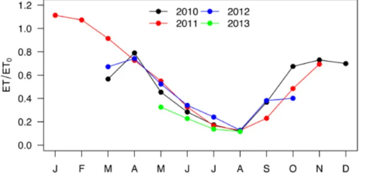
A specific focus has also been given to the drivers of ET, which is the second major flux after rainfall in the Mediterranean
Fig. 6. Temporal variation in the effective sorption coefficient for diuron vs. cumulated rainfall since application, observed for 7 yr in Roujan (adapted from Louchart and Voltz, 2007).
hydrological cycle. The relief and cropping patterns of the farmed land in the hilly areas of the OMERE catchments led us to exam-ine the effects of slope and canopy geometry on the estimation and modeling of land ET. Indeed, concerning sloping conditions, a major knowledge gap is the influence of topography on the structure of turbulence within the boundary layer (Raupach and Finnigan, 1997). Few data exist in farmed hilly areas, although they are common in many parts of the world. In this respect, we collected eddy covariance measurements across a typical slope of the Kamech catchment and found that airflow inclination was strongly influenced by the combined effects of wind direction, topography, and vegetation height. Consequently, novel methods were developed to correct and gap-fill the eddy covariance measure-ments on slopes by considering vegetation height, slope, and wind direction at the field (Zitouna-Chebbi et al., 2012, 2015; Boudhina et al., 2018) and hillslope scales (Zitouna-Chebbi et al., 2018). As an example, Fig. 7 presents the seasonal evolution of actual ET across the northern hillslope of the Kamech catchment. The ratio of actual to reference ET was systematically high from fall to early spring and very low during summer; the interannual variability observed in spring and fall was related to the variability of rainfall amounts. Concerning crop geometry, the impact of row cropping on ET fluxes has already been demonstrated (Riou et al., 1994), but its simulation remained rather empirical. Dedicated monitoring campaigns (Trambouze et al., 1998; Trambouze and Voltz, 2001) enabled the acquisition of detailed ET and soil moisture data on rows and interrows at the vineyard scale to test and upgrade models for simulating ET of crops planted in rows. The main improve-ments were the inclusion of a dedicated light interception scheme in existing models (Bsaibes, 2007; Galleguillos et al., 2017) and the development of a three-source Soil–Vegetation–Atmosphere Transfer (SVAT) model, dedicated to grassed vineyards (Montes
et al., 2014).
Aggregation Effects of Farming
and Land Management
A major issue when studying farmed catchments is to under-stand how farming and land management at the local scale influence water and soil resources at the catchment scale. Analysis of the observed data at plot, hillslope, and catchment scales has allowed for the identification of several specific situations, accord-ing to the nature of fluxes and land management. In this respect, the comparison of Roujan and Kamech catchments was fruitful since they exhibit different features of land management. Indeed, both catchments exhibit farming across a large part of their area, but in Roujan, land management over the centuries has led to ter-raced slopes and a man-made hydrographic network, whereas in Kamech, land management has only consisted of the building of a hill reservoir at the catchment outlet, and the natural hydrographic network that consists of a dense network of long-term stable gullies has not been deeply modified (i.e., perennial).
The scale effect, namely, the issues related to the extrapolation (upscaling) of local (field) measurements or fluxes to catchments,
was studied for surface runoff and erosion transfers in both catch-ments. Large-scale effects were observed in the Roujan catchment as a result of its network of ditches that collect water and erosion fluxes from the fields and route them to the outlet. Observations confirmed their overall control on floods (Moussa et al., 2002), groundwater recharge (Dagès et al., 2009), erosion fluxes (Raclot et al., 2009), or pesticide transfer (Louchart et al., 2001; Dagès et al., 2015; Dollinger et al., 2016, 2017, 2018). The estimation of the hydrological water balance of the central depression of the Roujan catchment (Fig. 8) showed that, despite comprising a small fraction of the area (1% of catchment area), ditches concentrate 50% of autumnal groundwater recharge (Dagès et al., 2009), which indicates the existence of substantial reinfiltration in ditches. It thus explains, in part, that the observed annual erosion rate and herbicide losses at the catchment outlet are more than one order of magnitude less than the sum of the edge of field losses (Louchart et al., 2001; Raclot et al., 2009; Dagès et al., 2015; Dollinger et al., 2018). For erosion, the scale effect must also be related to sedimen-tation in the interfield elements (e.g., in natural vegesedimen-tation strips at the edges of the plots or in ditches). For pesticides, significant retention processes occur during transport in ditches because of sorption to the ditch bed soil material, whose characteristics vary largely, according to the maintenance operations of the ditch (Dollinger et al., 2016, 2017). Conversely, the presence of a dense ditch network in the Roujan catchment was observed to weaken the general hillslope effect on the spatial variation of soil water content, which is observed in many catchments where the influ-ence of topography leads to much wetter downslope areas than those upslope. Indeed, the ditch network suppresses or restricts the lateral connectivity between fields with regard to surface runoff. Hébrard et al. (2006) thus observed that spatial variation of top-soil water content was predominantly controlled by the field top-soil surface characteristics, as related to farming practices, and not by nonlocal factors such as topography attributes. In the same line, it was found that ET fluxes across the catchment could be evaluated by simply aggregating the field-scale fluxes (Bsaibes, 2007). This result justified the estimation of vineyard ET across large areas,
Fig. 7. Seasonal evolution of the ratio of actual (ET) to reference (ET0) evapotranspiration at the hillslope scale across 4 yr in Kamech. Actual evapotranspiration was measured by the flux tower installed on the northern hillslope of Kamech, whereas ET0 was measured by the meteorological station (adapted from Zitouna-Chebbi et al., 2018).
using remote sensing methods, by combining field-scale ET estima-tion derived from soil moisture content and eddy covariance flux tower (Galleguillos et al., 2011a, 2011b, 2017).
In the Kamech catchment, in contrast with Roujan, runoff and erosion rates and their dynamics were found to be of the same order of magnitude at field and catchment outlets (Mekki et al., 2006; Inoubli et al., 2017), suggesting a small influence of the gul-lies network. Two specific surveys were thus conducted to better understand the role of gullies in Kamech: one at the gully scale using regular intensive field surveys (El Khalili et al., 2013), and a second at catchment-scale using a radionuclide-based fingerprint-ing approach (Ben Slimane et al., 2013). The results showed that rill and interrill erosion contributed ?80% of the outlet sediment fluxes, which means that gullies in Kamech behave more as ele-ments facilitating water and sediment transfer than as sediment sources or sediment trapping locations, which is very different from the ditch networks in Roujan. However, applications of fingerprinting methods in four other Tunisian reservoirs showed that the role of gully erosion in total erosion is very dependent on the catchment context (Ben Slimane et al., 2016). Concerning a hill reservoir, which is typical of the water-harvesting structures that have been increasingly adopted in Mediterranean regions, the observations of OMERE were aimed at establishing its water bal-ance. The impact of hill reservoirs on the depletion of hydrological regimes downstream is well known, but their impact on the whole hydrological balance had not been quantified in the literature. A thorough water balance analysis in Kamech demonstrated that the reservoir–subsurface exchanges were by far the main output component in water balance (Bouteffeha et al., 2015). This result may somewhat change the paradigm of hill reservoir water management, as it generally relies on a tradeoff between keep-ing water in the reservoir for the long-term use in the dry season and using water in the short term to avoid losses by evaporation. Knowledge that the major losses are probably due to infiltration
to groundwater suggests that the key water harvesting effect of hill reservoirs may rather be to recharge groundwater and strengthen deep water resources.
In summary, the OMERE observations clearly illustrate the major impact of land management on hydrological variables in the Mediterranean context. According to the state or flux variables, land management can either reinforce or blur the difference in hydrological response between field and catchment but is always a main factor to be taken into account for understanding, predict-ing, and managing water resources in Mediterranean catchments.
Toward New Scenarios for
Sustainable Agricultural Management
The design and evaluation of scenarios for more sustain-able agricultural management and improved ecosystem services in farmed Mediterranean landscapes have been one of the main long-term objectives of the observatory. Because experiments at the catchment scale are not feasible, modeling approaches were adopted to answer the latter objective and to allow for the numer-ical evaluation of scenarios. To this aim, in a first step, a series of physically based hydrological models have been progressively developed, taking into account the main processes and drivers of water, erosion, and contaminant fluxes in both OMERE catch-ments. The main specific and common feature of the developed models is the subdivision of each catchment into “hydrological units” of irregular shape, according to the hydrological discon-tinuities of farmed catchments. This feature allows the explicit representation of many of the particular characteristics of farmed areas, such as field boundaries, change in land use, and agricul-tural practices between fields, grass strips, ditches, and bank networks. The series of models consists of MHYDAS (Moussa et al., 2002) for runoff generation and transfer, MHYDAS-Erosion (Gumiere et al., 2011), and LandSoil (Ciampalini et al., 2012) for soil erosion and particle transfer, MHYDAS-Pesticides
Fig. 8. Water balance of the central depression of the Roujan catchment, calculated for the period of 7 to 20 Oct. 2005. CR, DR, and DS stand for con-centrated recharge, diffuse recharge, and water volume variations in groundwater and in the vadose zone, respectively (adapted from Dagès et al., 2009).
(Bouvet et al., 2010) for organic contaminant transfer, and Geo-MHYDAS for landscape segmentation (Lagacherie et al., 2010), with MHYDAS standing for Modélisation hydrologique spatial-isée des agrosystèmes (spatially distributed hydrological modeling of agrosystems). The OMERE database has been extensively used for calibrating and validating the models. Multiscale calibration procedures were specifically developed for taking advantage of the OMERE nested monitoring system (Hallema et al., 2013, Gumiere et al., 2014). Moreover, to support the development of these models, a comprehensive software platform, OpenFLUID, was set up for helping modelers to build spatially distributed landscape models (Fabre et al., 2010).
Several applications of these models have already been used. Most of them first intended to analyze the impact of landscape organization, namely, the distribution of agricultural field man-agement and land infrastructures, on soil and water resources. Second, the applications were intended to derive the optimal design of land management for improving ecosystem services. The earliest applications studied numerically whether catch-ment streamflow and erosion can vary significantly, depending on ditch network geometry and topology (Moussa et al., 2002;
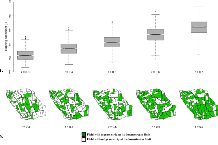
Levavasseur et al., 2012), and on the spatial organization of soil tillage, weeding practices, or vegetated filter strips (e.g., Fig. 9; Moussa et al., 2002; Biarnès and Colin, 2006; Colin et al., 2012; Gumiere et al., 2015). These applications also determined the optimal spatial organization of the latter management prac-tices that maximizes or minimizes runoff characteristics (peak, time lag, volume, etc.). Additionally, scenarios of global change, combining climate change and land-use change, were tested for guiding soil conservation practices (David et al., 2014; Paroissien et al., 2015). Other applications concerned the assessment of the influence of landscape spatial organization on pesticide dissipa-tion. In a multidisciplinary study, MHYDAS pesticide was used for evaluating several soil treatment strategies in Mediterranean vineyard areas, chosen by a group of experts to restrict the use of herbicides and decrease the overall water contamination by pesticides but still secure grape yields (Biarnès et al., 2017). In another study, the influence of the geometry of ditches and of their spatial distribution on pesticide fate within the catchment was also addressed by simulation. The results obtained to date indicate the possibility for increasing pesticide retention of the ditch networks by adapting their geometry and by specific
Fig. 9. Simulated effects of grass strip density on the sediment yield at the Roujan catchment outlet, using the MHYDAS-Erosion model and a stochas-tic generation model of grass strip locations. Panel (a) shows boxplots of the sediment trapping efficiency (i.e., the percentage of sediment reduction due
to sediment trapping by grass strips, considering a grass strip density [r] varying from 0.3 to 0.7 and 800 repetitions of grass strip locations computed
according to a Monte Carlo-based numerical procedure). The notches indicate the 95% confidence interval of the median value, and the whiskers indi-cate the 25th and 75th percentiles of the trapping coefficient distribution. Panel (b) shows the best configuration of grass strip locations, with regard to soil loss reduction at the Roujan outlet, for grass strip density ranging from 0.3 to 0.7 (adapted from Gumiere et al., 2015).
maintenance operations (Dagès et al., 2016). All these simulation results helped to produce guidelines for improved soil and water management by local stakeholders.
6
Retrospective Analysis of
Observation Design Evolution
The OMERE observatory was founded in 2002, but the two farmed catchments had already been in operation since the 1990s. Therefore, the observation design of OMERE is now more than 25 yr old. It largely evolved during this period. Below, we share some lessons that emerge, in our opinion, from the long-term monitoring experience and conclude with some perspectives.
First, the instrumentation design has to be permanently improved and questioned. This design is related not only to the evolution of measurement techniques, but also and even more to the natural change and expansion of scientific issues that the observatory aims to meet. As previously mentioned, the OMERE catchments were first established to elucidate the influence of changes in land-use practice on surface water resources. Regarding land-use practices, both catchments were particularly relevant for studying farming practices and landscape infrastructures, such as ditches in Roujan and hill reservoirs in Kamech. Accordingly, from the beginning, a monitoring design with embedded spatial scales from plot to catchment scales was defined. However, it was mainly limited to monitoring surface runoff. With time, it became clear that land-use practices had a very strong influence on many interacting fluxes, and reciprocally, that they were also affected by these fluxes at the landscape scale. Therefore, a more comprehensive observation design was developed, step by step, for monitoring all components of the hydrological balance, namely, surface–subsurface interactions and atmospheric fluxes. The design also considered the monitoring of sediment fluxes, since farmers and local land managers expressed their interest in this topic. In contrast, the monitoring of contaminant fluxes was due to the initiative of a researcher and took place after a few years. This monitoring has yet to be reinforced on the Kamech obser-vatory. However, at the start of the OMERE observatory in the early 1990s, it was already well observed that intensive agricul-ture was a source of water pollution by nitrates and pesticides in North America and northern Europe, but little information was available in Mediterranean regions, and most farmers and land managers were not aware of this threat or preferred to ignore it. Given the intense use of pesticides on permanent Mediterranean crops such as vineyards or fruit orchards, on one hand, and the intense wash-off potential of the Mediterranean rain events, on the other hand, it was very probable that Mediterranean agricultural areas had to face water pollution issues, similar to those of more northerly regions but with different patterns. The data collected in the Roujan catchment helped to recognize the issue and to guide the farmers in modifying their weeding practices. This illustrated the potential role of an environmental long-term observatory in anticipating new environmental and social issues.
Second, long-term monitoring is not self-evident at first sight, neither for those who manage observatories, nor for funding agen-cies or for the scientific community. This became evident only with time. When the OMERE catchments were initiated, they were thought to last only a few years, until a good picture of the impacts of land-use changes on hydrological flows could be obtained. Progressively, several reasons motivated researchers to maintain and to expand the observation facility for longer terms. The first reason was the inherent temporal variability of processes that required long-term observation to identify either slow-rate processes or scarce events with strong impacts. This point is illustrated by the pesti-cide losses, occurring mainly during a few intense rainfall events by surface runoff, while desorption rates are submitted to slow changes at the seasonal timescale (Lennartz et al., 1997; Louchart et al., 2001, 2004). A second reason was the advantage of using the observatory for short-term specific experimental investigations. On this point, the established basic observation infrastructure and the available monitoring records of the observatory facilitate both the implementation of any new investigation and the discussion of the generic significance of its results, within the variability of processes already observed. A third reason was the attractiveness of a unique experimental site to foster multidisciplinary collaborative work and the establishment of common research paradigms between scientific fields. For example, collaborative actions involving hydrology and geophysics allowed the development and testing of the self-potential method to monitor infiltration rates and groundwater levels (Revil et al., 2002; Suski et al., 2006; Linde et al., 2007).
Third, in environmental sciences, observation infrastructures have to be linked as closely as possible to modeling approaches. Modeling helps to interpret the observed dynamics and to test hypoth-eses about the underlying mechanism and can also guide the design of the observation setup. Moreover, modeling is a means for extending the significance of the results of an observatory. Indeed, the general sig-nificance of the observations provided by environmental observatories such as OMERE is intrinsically limited by the specific characteristics of the instrumented area and by those of the observational periods. In this respect, fitting and testing models with an extensive database helps not only to improve models but also to extract general information from the database, such as the values of physically based model param-eters. This will then support simulation in different locations and/or time periods, provided that the acting processes remain similar. As an example, due to the OMERE database, the MHYDAS-Pesticides model was thoroughly fitted and could be applied successfully on other vineyard catchments to compare the impact of soil treatment scenar-ios (Biarnès et al., 2017). Similarly, the adaptation of the Hydrus-1D model to row vineyards (two-dimensional) was first tested using the OMERE database before being applied to vineyards located in the surrounding region (Galleguillos et al., 2017).
6
Conclusions and Perspectives
Here, we have provided an overview of the OMERE obser-vatory, a Mediterranean observatory that contains two farmed