HAL Id: hal-02982420
https://hal.inria.fr/hal-02982420
Submitted on 28 Oct 2020
HAL is a multi-disciplinary open access
archive for the deposit and dissemination of
sci-entific research documents, whether they are
pub-lished or not. The documents may come from
teaching and research institutions in France or
abroad, or from public or private research centers.
L’archive ouverte pluridisciplinaire HAL, est
destinée au dépôt et à la diffusion de documents
scientifiques de niveau recherche, publiés ou non,
émanant des établissements d’enseignement et de
recherche français ou étrangers, des laboratoires
publics ou privés.
A causal hierarchical Markov framework for the
classification of multiresolution and multisensor remote
sensing images
Alessandro Montaldo, Luca Fronda, Ihsen Hedhli, Gabriele Moser, Sebastiano
Serpico, Josiane Zerubia
To cite this version:
Alessandro Montaldo, Luca Fronda, Ihsen Hedhli, Gabriele Moser, Sebastiano Serpico, et al.. A
causal hierarchical Markov framework for the classification of multiresolution and multisensor remote
sensing images. ISPRS 2020 - XXIV International Society of Photogrammetry and Remote Sensing
Congress, Aug 2020, Nice / Virtual, France. pp.269-277, �10.5194/isprs-annals-V-3-2020-269-2020�.
�hal-02982420�
A CAUSAL HIERARCHICAL MARKOV FRAMEWORK FOR THE CLASSIFICATION
OF MULTIRESOLUTION AND MULTISENSOR REMOTE SENSING IMAGES
Alessandro Montaldo1, Luca Fronda1, Ihsen Hedhli2, Gabriele Moser1, Sebastiano B. Serpico1, and Josiane Zerubia3 1
University of Genoa, Italy, [email protected]´e Laval, Quebec, Canada 3Inria, Universit´e Cˆote d’Azur, Sophia Antipolis, France, [email protected]
Commission III, WG III/6
KEY WORDS: Multiresolution and multisensor fusion, causality, hierarchical Markov random models, Markov chain, semantic image segmentation.
ABSTRACT:
In this paper, a multiscale Markov framework is proposed in order to address the problem of the classification of multiresolution and multisensor remotely sensed data. The proposed framework makes use of a quadtree to model the interactions across different spatial resolutions and a Markov model with respect to a generic total order relation to deal with contextual information at each scale in order to favor applicability to very high resolution imagery. The methodological properties of the proposed hierarchical framework are investigated. Firstly, we prove the causality of the overall proposed model, a particularly advantageous property in terms of computational cost of the inference. Secondly, we prove the expression of the marginal posterior mode criterion for inference on the proposed framework. Within this framework, a specific algorithm is formulated by defining, within each layer of the quadtree, a Markov chain model with respect to a pixel scan that combines both a zig-zag trajectory and a Hilbert space-filling curve. Data collected by distinct sensors at the same spatial resolution are fused through gradient boosted regression trees. The developed algorithm was experimentally validated with two very high resolution datasets including multispectral, panchromatic and radar satellite images. The experimental results confirm the effectiveness of the proposed algorithm as compared to previous techniques based on alternate approaches to multiresolution fusion.
1. INTRODUCTION
Thanks to the potential offered by current and forthcoming space missions, very high spatial resolution (VHR) optical (e.g., Pl´eiades, WorldView-3, SPOT-6/7) and synthetic aper-ture radar (SAR; e.g., COSMO-SkyMed Seconda Generazione, TerraSAR-X, RADARSAT-2) instruments are now available to serve many applications. From the viewpoint of image ana-lysis, the joint exploitation of the resulting data requires novel methods that operate with images collected by multiple sensors on the same area at multiple spatial resolutions. This is highly promising because it allows to benefit from data associated with different physical natures, frequencies, polarizations, etc., and from the tradeoff between a synoptic view at coarser resolu-tions and the spatial detail of finer resoluresolu-tions. In this paper, the semantic segmentation (Wang, 2016, Arnab et al., 2018) or dense supervised classification of images that are both mul-tiresolution and multisensor is addressed. A major challenge in this joint multisensor-multiresolution scenario is the combina-tion of heterogeneous statistics of the input images and of the need to characterize spatial information associated with differ-ent resolutions (Hedhli et al., 2017). Trivial well-known solu-tions mostly use resampling procedures and do not attempt to capture the multiresolution structure of the data explicitly. Here, an approach to address multiresolution fusion is pro-posed based on hierarchical latent Markov modeling (Li, 2009). Within the family of structured output learning meth-ods, Markov models postulated on planar or multilayer graphs are known as flexible and powerful stochastic models for spatial and possibly multimodal information (Li, 2009). A common shortcoming of generic Markov random fields (MRFs) is their non-causality that generally leads to possibly time-consuming
inference algorithms. The resulting non-convex problems are addressed with stochastic optimizers such as simulated anneal-ing (Li, 2009) or graph-theoretic algorithms (Boykov et al., 2001). In opposition to the case of classical MRFs, for causal probabilistic 1D models (e.g., Markov chains) efficient sequen-tial techniques (e.g., the Baum-Welch algorithm (Baggenstoss, 2001)) are widely used for inference. Indeed, an effective approach to multiresolution and multisensor fusion addressed with Markov modeling is to postulate Markovianity on a hier-archical graph structure (e.g., systems of quadtrees (Hedhli et al., 2017)). However, despite hierarchical MRFs on quadtrees capture relations among sites located at different scales through the use of a Markov chain, a common limitation is that they do not explicitly characterize spatial dependences within the layer at each resolution (Lafert´e et al., 2000).
To join the benefits of both hierarchical and planar MRFs, the classification of multiresolution and multisensor remote sens-ing data is formulated in this paper through a causal hierarch-ical Markov framework. The contribution of the paper is two-fold. First, we extend the approach developed in (Montaldo et al., 2019a, Montaldo et al., 2019b), in which hierarchical MRFs on quadtrees have been combined with planar Markov meshes and with various pixelwise probabilistic models, to a broader framework in which each layer of the quadtree is asso-ciated with a Markov model with respect to an arbitrary total order relation. The resulting framework is highly general and includes the Markov meshes in (Montaldo et al., 2019a, Mont-aldo et al., 2019b) as a special case. Secondly, within this gen-eralized framework, we develop a novel algorithm that is based on a Markov chain model (Fjortoft et al., 2003) on each layer of the quadtree. In this model, Markov chains are formulated both across the scales of the tree and with respect to a 1D scan of the
pixel lattice of each layer. This joint strategy benefits from the spatial information within each layer and inherently supports multiresolution fusion. A case-specific scan is defined on each layer of the quadtree by integrating a simple zig-zag trajectory and a Hilbert space-filling curve (Abend et al., 1965). Method-ologically, we prove that the proposed generalized framework ensures causality for the whole probabilistic graphical model, thus favoring efficient inference. Then, we derive the analytical formulation of the marginal posterior mode (MPM) inference algorithm for the proposed framework and we customize it to the special case of the aforementioned Markov chain. MPM is especially advantageous for classification and segmentation in a multiresolution scenario (Lafert´e et al., 2000) and its formu-lation for causal hierarchical Markov models explicitly relies on the causality of the models. In the proposed framework, the images coming from the various sensors are inserted in a quadtree based on their resolutions. On one hand, when dis-tinct sensors provide data at different resolutions, multisensor fusion is accomplished naturally thanks to the adopted hierarch-ical topology. On the other hand, when data sources from dis-tinct sensors are available at the same resolution, multisensor fusion is addressed by incorporating a nonparametric ensemble method within the proposed algorithm. Similar to (Montaldo et al., 2019a, Montaldo et al., 2019b), gradient boosting regres-sion trees (GBRT) (Friedman, 2001) are employed in this role.
2. METHODOLOGY 2.1 Causal hierarchical Markov models
Among the main current trends of probabilistic graphical els in remote sensing, multiscale and multiresolution mod-els are of primary importance. The rationale is that comple-mentary information is appreciated at different spatial scales. While fine-scale observations provide lots of geometrical de-tail but are spatially heterogeneous and noise-sensitive, coarse-scale observations capture only large image regions and cov-ers but with strong robustness to noise and outlicov-ers. Many multiscale or multiresolution graphical models have been in-troduced on the basis of hierarchical graphs (Willsky, 2002), such as quadtrees (Lafert´e et al., 2000). With this topology, hierarchical MRF models typically involve Markovianity along the scale axis. However, a limitation of a hierarchical MRF on a quadtree is that, while it captures relations among data at different scales through a Markov chain, it generally does not characterize spatial dependencies within the layer at each scale (Lafert´e et al., 2000). Here, a causal hierarchical frame-work that postulates Markovianity not only among pixels be-longing to pixel lattices with different resolutions but also among pixels in the same lattice is defined. This framework describes both cross-layer (multiscale) and intra-layer (spatial) dependence relations.
2.1.1 Planar causal Markov models Let R ⊂ Z2 be a planar rectangular pixel lattice and let us define a total order relationE on R. This means that this relation fulfills the fol-lowing properties (r, s, t ∈ R):
Antisymmetry: rE s, sE r =⇒ r = s Transitivity: rE s, sE t =⇒ rE t
Connexity: at least one holds between rE s and s E r. We shall also write r C s to indicate that r E s and r 6= s. Accordingly, the set {r ∈ R : r C s} formalizes the idea
Figure 1. Quadtree structure and notations on the tree
of the “past” of site s ∈ R. Let us consider also a neighbor-hood relation to be defined in R consistently with the order relationC, so that, intuitively, it makes sense to speak of the “past neighbors” or “recent past” of each site. We write rJ s to indicate that r is one of such past neighbors of s. Formally, {r ∈ R : r J s} ( {r ∈ R : r C s}, i.e., the past neighbors of s ∈ Rare all included in the past of s but form a proper (strict) subset of its entire past. Normally, this subset is meant to be small to favor low computational burden in the inference.
Let a discrete random variable xsbe attached to each site s ∈ R and let X = {xs}s∈R be the corresponding random field. A Markovianity property restricted to the past of each site holds for X if (Abend et al., 1965, Devijver, 1993, Willsky, 2002):
P (xs|xr, rC s) = P (xs|xr, rJ s) ∀s ∈ S. (1) This notion of causal Markovianity on a planar lattice extends the one discussed in (Montaldo et al., 2019a, Montaldo et al., 2019b), in which the order relation was referred to a 2D mesh. We also recall that it can be proved for several planar causal Markov models (including Markov meshes of second and third order and Markov chains) that the following factor-ization holds (Abend et al., 1965):
P (X ) =Y s∈R
P (xs|xr, rJ s), (2)
up to properly defining the behavior of X at the image borders.
2.1.2 Hierarchical causal Markov random fields Let now {S0, S1, . . . , SL} be a collection of pixel lattices organized as a quadtree, as shown in Fig. 1. This hierarchical structure is ar-ranged so that the width and the height of S`−1are twice smal-ler than those of S`(` = 1, 2, . . . , L). If ` ∈ {1, 2, . . . , L}, each site s ∈ S` in layer S` has a well-defined parent site s− ∈ S`−1. If ` ∈ {0, 1, . . . , L − 1}, each site s ∈ S`has in S`+1 four well-defined children sites, which we collect in the set s+⊂ S`+1. These definitions imply a hierarchy on the whole tree S = S0∪S1∪. . .∪SL
from the root S0to the leaves SL(Lafert´e et al., 2000). If again a discrete random variable xs is associated with each s ∈ S, then X = {xs}s∈Sis a hierach-ical MRF on the quadtree if the following property holds for all
layers but the root (` = 1, 2, . . . , L) (Lafert´e et al., 2000): P (X`|X`−1,X`−2, . . . , X0) =
= P (X`|X`−1) = Y s∈S`
P (xs|xs−), (3)
where X` = {xs}s∈S` (` = 0, 1, . . . , L). The first equality
in (3) indicates that Markovianity is valid across the layers of the quadtree. The second equality expresses that the transition probability P (X`|X`−1)from the (` − 1)th to the `th layer fac-torizes on a pixelwise basis. Accordingly, a hierarchical MRF on a quadtree describes the dependence along the scale axis but not the spatial-contextual dependence associated with the ran-dom field X`that is supported on each layer S`.
2.2 The proposed framework
2.2.1 Model assumptions In this paper, we formulate a general framework for the joint fusion of multisensor and mul-tiresolution images in a supervised classification scenario. The key-idea of the proposed framework is to generalize the ap-proaches in (Montaldo et al., 2019a, Montaldo et al., 2019b) by introducing a hierarchical Markov model with respect to a quadtree topology and to an arbitrary total order relation on each layer of the tree. Considering a set of well-registered im-ages acquired by distinct VHR sensors at different spatial resol-utions on the same area, each image is included in a correspond-ing layer of the quadtree. Hence, the resolutions of the input images should be in a power-of-2 relation. This is a restriction, but given the resolutions of current VHR sensors, it can be eas-ily met up to minor resampling (Dikshit, Roy, 1996, Inglada et al., 2007) and appropriate antialiasing filtering (Alparone et al., 2008, Mallat, 2009). The hierarchical model naturally fits the requirements of multiresolution fusion. Furthermore, the relationsC, E, and J are assumed to be defined within each planar layer of the quadtree. From a graphical viewpoint, this implies that every site s ∈ S` of every layer S`but the root (` = 1, 2, . . . , L) is linked to one parent s−∈ S`−1located in the upper layer and to the past neighbors {r ∈ S` : r
J s} located in its own layer. A pixel in the root S0 has no parent and only the causal neighbors, if any.
With the same notations as above, xsis now meant as the class label of site s ∈ S and a finite set Ω of classes is assumed to be defined by a training map (xs ∈ Ω, s ∈ S). For each s ∈ S, let Csbe the vector collecting the labels of all nodes linked to s (the “context” of s), i.e., Cs= {s−} ∪ {r ∈ S`: r
J s} if s is not in the root (s ∈ S \ S0), and Cs= {r ∈ S0 : r
J s} if s ∈ S0is in the root. As the input multisensor and multiresolution images are framed in the quadtree, each s ∈ S is also associated with a feature vector ys. Thus, a random field Y = {ys}s∈S of observations is defined. If a site s is not in the leaf layer (s ∈ S \ SL), then we shall denote as Dsthe vector collecting the feature vectors of all sites that descend from s ∈ S in the quadtree. If s in the leaf layer (s ∈ SL), we set Ds= ys. The proposed framework is defined by the following assumptions:
1. X is Markovian across the scales as in (3) and the fol-lowing proportionality and factorization hold on all layers except the root (` = 1, 2, . . . , L):
P (X`|X`−1, X`−2, . . . , X0) = P (X`|X`−1) ∝ ∝ Y
s∈S`
P (xs|xr, rJ s)P (xs|xs−). (4)
2. On the root, X0satisfies the factorization in (2): P (X0) = Y
s∈S0
P (xs|xr, rJ s). (5)
3. Conditional independence holds for the observations given the class labels:
P (Y|X ) =Y s∈S P (ys|xs) = L Y `=0 Y s∈S` P (ys|xs). (6)
4. The label of each site, given the labels of the sites linked to it, only depends on the observations of its descendants and not on those of the other sites:
P (xs|Cs, Y) = P (xs|Cs, Ds) ∀s ∈ S. (7) 5. Given the observation field, the parent and neighboring
la-bels of each site are conditionally independent:
P (Cs|Y) = ( P (xs−|Y)Q rJsP (xr|Y) ∀s ∈ S \ S 0 Q rJsP (xr|Y) ∀s ∈ S 0 (8) 6. The parent and neighboring labels of each site, when con-ditioned to the label of that site, are independent on the observations of its descendants and mutually independent: P (Cs|xs, Ds) = P (Cs|xs) = (9) = ( P (xs−|xs)Qr JsP (xr|xs) ∀s ∈ S \ S 0 Q rJsP (xr|xs) ∀s ∈ S 0
These assumptions play different roles within the proposed framework. On one hand, methodologically, the framework is defined by Assumptions 1, 2, and 3. Assumption 1 expresses the key idea of the proposed combination of a hierarchical MRF on a quadtree and a causal planar Markov model with respect to a generic order relationE. It implies that Markovianity holds across the scales and that the corresponding transition probab-ilities factorize so that the labels in each layer convey both con-textual and multiscale dependencies. Accordingly, the model can characterize both multiresolution and spatial information. From this perspective, Assumption 2 is necessary for complete-ness, as it ensures that the analogous spatial factorization holds on the root as well. The conditional independence in Assump-tion 3 is a commonly accepted statement in the applicaAssump-tion of MRFs to image classification and is used in the proposed frame-work to favor tractability. On the other hand, Assumptions 4, 5, and 6 are not meant to formalize specifically desired behavi-ors of the proposed model. As we shall argue in more detail in the next section, they are basically technical conditions that fa-vor the analytical tractability of the inference. They are similar in nature to conditional independence hypotheses that are often stated for mathematical convenience when operating with either hierarchical (Lafert´e et al., 2000) or planar MRFs (Li, 2009). Regarding inference within the proposed framework, we use the MPM criterion, i.e., s ∈ S is assigned to the class ω ∈ Ω that maximizes P {xs = ω|Y}(Li, 2009). MPM is especially appropriate for hierarchical MRFs because it penalizes errors according to the scale on which they are made, which is desir-able to avoid error accumulation along the layers (Lafert´e et al.,
2000). We shall prove in the next section that the proposed framework is causal both spatially and across scales, which makes it possible to compute P (xs|Y) on each s ∈ S recurs-ively and efficiently. As data associated with different resolu-tions are associated with the observaresolu-tions in distinct layers of the quadtree, this recursive inference inherently accomplishes their fusion, thus jointly classifying multisensor data suppor-ted at different resolutions. If two or more considered input sensors correspond to the same resolution, then their data con-tribute to the feature vectors in the same layer (stacked vec-tor). In this case, multisensor fusion is obtained by integrat-ing the GBRT ensemble of decision trees (Friedman, 2001) in the MPM scheme (see Section 2.3). The flexibility of tree en-sembles and their applicability to highly heterogeneous input feature vectors allows the proposed framework to address multi-sensor fusion in this case as well.
2.3 Methodological properties and MPM inference Here, we prove the causality of the proposed hierarchical Markov framework and we derive a set of relations that allows computing the MPM functional P (xs|Y) of each site s ∈ S. Operatively, the causality is expressed in terms of the factoriz-ation of the joint distribution of all observfactoriz-ations and labels in terms of causal transition probabilities.
Theorem 1. Under Assumptions 1-3, the joint distribution P (X , Y) of all class labels and feature vectors in the quad-tree is entirely defined by the parent-child transition probabilities {P (xs|xs−)}s∈S\S0, the past neighbor transition probabilities
{P (xs|xr, rJ s)}s∈S, and the pixelwise data conditional like-lihoods {P (ys|xs)}s∈S.
Proof. According to (3), Assumption 1 implies that:
P (X , Y) = P (Y|X )P (X ) = P (Y|X )P (XL, XL−1, . . . , X0) = P (Y|X )P (XL|XL−1) . . . P (X1|X0)P (X0). (10) Plugging the factorizations (6) for P (Y|X ), (5) for P (X0), and (4) for P (X`|X`−1 )(` = 1, 2, . . . , L) into (10) yields: P (X , Y) ∝ L Y `=1 Y s∈S` P (xs|xr, rJ s)P (xs|xs−)P (ys|xs)· · Y s∈S0 P (xs|xr, rJ s)P (ys|xs). (11)
Therefore, P (X , Y) is entirely defined by the parent-child transition probabilities P (xs|xs−), the past neighbor transition
probabilities P (xs|xr, r J s) and the data conditional likeli-hoods P (ys|xs).
Theorem 2. Under Assumptions 1-6, for each site s ∈ S \ S0 not in the root1:
P (xs) =X xs− P (xs|xs−)P (xs−), (12) P (xs|Cs, Ds) ∝ P (xs|Ds)P (xs|xs−)P (xs−)P (xs)−|Cs|· ·Y rJs P (xs|xr)P (xr), (13) P (xs|Y) =X Cs P (xs|Cs, Ds)P (xs−|Y) Y rJs P (xr|Y). (14) 1 We denote as |A| the cardinality (i.e., the number of elements) of a
finite set A.
For each root site s ∈ S0: P (xs|Cs, Ds) ∝ P (xs|Ds) P (xs)|Cs| Y rJs P (xs|xr)P (xr), (15) P (xs|Y) =X Cs P (xs|Cs, Ds)Y rJs P (xr|Y). (16)
For each site s ∈ S \ SLnot in the leaf layer: P (xs|Ds) ∝ P (xs|ys) Y t∈s+ X xt P (xt|Ds)P (xt|xs) P (xt) . (17)
Proof. First, (12) is a straightforward application of the total probability theorem, and the proof of (17) is the same as that reported in (Lafert´e et al., 2000) for a hierarchical MRF. Then, the total probability theorem implies that:
P (xs|Y) =X Cs
P (xs|Cs, Y)P (Cs|Y), (18)
and (14) and (16) follow from plugging (7) and (8) into this equation. Moreover, thanks to Bayes theorem:
P (xs|Cs, Ds) ∝ P (Cs|xs, Ds)P (xs|Ds), (19) where the proportionality constant does not depend on xs. If s ∈ S \ S0and if we plug (9) into this equality, we obtain:
P (xs|Cs, Ds) ∝ P (xs|Ds)P (xs−|xs)
Y rJs
P (xr|xs), (20)
from which (13) follows due to Bayes theorem. The case of (15) is analogous.
Theorem 1 indicates that (X , Y) is a Markov chain with respect to the causal structure described above, which determines the causality of the proposed hierarchical Markov model. Hence, the proposed hierarchical Markov framework is causal both spatially and across scales, which allows an efficient recursive algorithm to be formulated for the MPM criterion. Based on Theorem 2, this criterion can be formulated in terms of three re-cursive steps. First, the prior probabilities P (xs)are initialized on the root and (12) is used to calculate them for each class on all sites of the quadtree through a top-down pass from the root to the leaves. Second, (17), (13), and (15) are used to compute P (xs|Cs, Ds)through a bottom-up pass from the leaves to the root and within the root. Third, (14) and (16) are used to derive P (xs|Y) through a second top-down pass within the root and from the root to the leaves.
2.4 Proposed Markov chain-based method
Different choices for the definition of the total order relationE, meaning different choices of the set of pixels which represent the past of a site s ∈ S, lead to different algorithmic formu-lations. In (Montaldo et al., 2019a, Montaldo et al., 2019b), a Markov mesh model was considered, which, in the generalized formulation of the present paper, is equivalent to saying that r C s if pixel r is a neighbor of s and is reached before s as the image is raster-scanned. Here, a Markov chain formulation is used, which implies that the past of a pixel is determined on a 1D basis according to a certain way of scanning all the pixels in a lattice.
Figure 2. Zig-zag scan
On each layer S`of the quadtree (` = 0, 1, . . . , L), let us con-sider a scan trajectory, i.e., a sequence that visits every pixel once and moves from one pixel to one of its neighbors. Given a pixel s ∈ S`, let us indicate as s?∈ S`
the previous pixel in the scan. We focus here on the special case in which rJ s if and only if r = s?. Accordingly, (4) and (5) characterize the spatial behavior of X as a first-order Markov chain. In particular, (13) and (14) simplify as follows (s ∈ S \ S0):
P (xs|xs−, xs?, Ds) ∝ P (xs|Ds)P (xs)−2· (21)
· P (xs|xs−)P (xs−)P (xs|xs?)P (xs?),
P (xs|Y) = X xs−,xs?
P (xs|xs−, xs?, Ds)P (xs−|Y)P (xs?|Y),
and (15) and (16) simplify analogously.
Two well-known ways to perform such a pixel scan include a zig-zag trajectory and the Hilbert space-filling curve. In the former case, a zig-zag scan over the lattice S`is performed as shown in Fig. 2. With the exception of the pixels at the border of the lattice, s?is the pixel adjacent to s and placed diagonally with respect to s in the direction of a zig-zag. Along the image borders, this trajectory aligns with the borders themselves. The latter scan option is based on the Hilbert space-filling curve over a power-two sized lattice S`(see Fig. 3). The rationale for the introduction of this order relation is twofold. First, the Hilbert curve is useful because it gives a mapping between 1D and 2D spaces that preserves locality, a precious property for contextual classification. This means that two points which are close to each other in the 1D scan are also close to each other after fold-ing. The converse may not always be true. Second, the Hilbert curve is particularly interesting in the case of a multiresolution data set as the recursive construction of the curve matches the power-of-2 relation of the layer sizes of the quadtree.
A typical drawback of causal Markov approaches is the possible presence of anisotropic corner-dependent artifacts. To prevent them, symmetrization procedures that ensure that, within the overall execution of the method, pixels are visited in a balanced and isotropic manner, are often necessary. In this paper, this drawback is addressed by defining the scan according to a sym-metrized combination of the aforementioned zig-zag and Hil-bert curves. The proposed scan is shown in Fig. 4 and results as a combination of four zig-zag scans and two Hilbert scans. It is accomplished by moving onto two different directions of the Hilbert curve and onto the zig-zag curves along the two diagon-als, in both possible directions. Through this scan, each site is visited multiple times in a symmetric manner, which prevents the risk of geometrical artifacts that may occur while integrat-ing contextual information in a 1D scan on a 2D pixel lattice. Indeed, if asymmetric scanning was used, directional artifacts
Figure 3. Hilbert space-filling curve
in the classification map may generally occur in the shapes of regions and edges (Yousefi, Kehtarnavaz, 2011).
The same approach used in (Montaldo et al., 2019a, Mont-aldo et al., 2019b) is used to define the transition probability P (xs|xs−)across consecutive scales. It consists of a
paramet-ric stationary model in which P {xs = ω|xs− = ω} = θ for
all ω ∈ Ω, where θ is a hyperparameter of the method, and P {xs= ω|xs−= ω0} is constant over all ω 6= ω0(ω, ω0∈ Ω).
Following the results obtained in (Hedhli et al., 2016) in the case of a multitemporal hierarchical MRF model, the impact of θon the results of the method are expected to be minor. An ana-logous model is used for the transition probability P (xs|xs?)
along the scan trajectory.
GBRT is used to estimate the pixelwise posteriors P (ys|xs) from the training samples of the classes. GBRT is an ensemble of decision trees that uses boosting (Schapire, 1990) to iter-atively and adaptively manipulate the training set in order to generate multiple decision trees. A weight is assigned to each training sample, and at each iteration the weighted error on the training set is minimized by a decision tree. Then the weights are updated so that larger weight is given to wrongly classi-fied samples and smaller weight is given to correctly classiclassi-fied samples. The final predictor is constructed by a weighted vote of the individual decision trees where the weights are given by the accuracy of the corresponding decision tree.
3. EXPERIMENTAL RESULTS 3.1 Data sets and experimental setup
The proposed method was experimentally validated with two VHR remote sensing datasets. The first one was collected over Port-au-Prince, Haiti, shortly after the 2010 earthquake. It consisted of an RGB GeoEye-1 image at 1.25 m resolu-tion (1024 × 1024 pixels), an RGB-NIR (near infrared) Quick-Bird image at 2.5 m resolution, and a SAR COSMO-SkyMed stripmap image at 5 m resolution. For the COSMO-SkyMed stripmap modality, 5 m is the spatial resolution corresponding
Steps 1, 2, and 3 of the scan
Steps 4, 5, and 6 of the scan
Figure 4. Symmetrized scan introduced. It consists of a combination of four zig-zag scans and two Hilbert scans (6 steps
illustrated in the figure).
to 4-look data. The resolution of the multispectral channels of QuickBird is 2.4 m, so minor resampling was applied. In the case of GeoEye-1, the resolutions of the multispectral and panchromatic channels are 1.64 and 0.41 m, respectively. The 1.25m image was obtained by resampling after pansharpen-ing. Pansharpened data were used as this was the format in which GeoEye-1 imagery was provided by the Google Crisis Response initiative2. In all resampling processes, proper an-tialiasing filtering was applied (Alparone et al., 2008, Mallat, 2009). The thematic classes in the data set included “build-ings,” “asphalt,” “containers,” “vegetation,” and “water.” In the desired output map, these classes were meant to be discrimin-ated at the finest observed resolution, i.e., 1.25 m. Yet, the pro-posed method also mapped them at the other observed scales, i.e., 2.5 and 5 m.
The second data set was acquired by the IKONOS optical mul-tiresolution sensor in 2004 over the area of Alessandria, Italy. It consisted of a single-channel panchromatic image at 1 m resolu-tion (1024 × 1024 pixels) and a 4-channel RGB-NIR multispec-tral image at 4 m resolution. The thematic classes in this data set were “urban,” “agricultural,” “rangeland,” “forest,” “bare soil,” “wet soil,” and “water.” As in the case of the first data set, they were meant to be discriminated on the 1 m lattice, although the method also provided a classification map at 4 m as a by-2 http://www.google.com/relief/haitiearthquake/geoeye.html
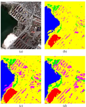
(a) (b)
(c) (d)
Figure 5. “Haiti” data set. Details of (a) the optical image at 1.25-m resolution and of the classification maps obtained using (b) a single-resolution MRF after resampling, (c) an adaptation
of the method in (Moser et al., 2016) to the case of input multisensor optical-SAR imagery, and (d) the proposed algorithm. Class legend:containers,vegetation,asphalt,
buildings,water.
product. The urban area was meant to be discriminated as a whole, without separating possible subclasses associated with ground materials.
For both data sets, non-overlapping training and test sets were manually annotated in homogeneous areas by a specialist. No borders were taken into account in the training and test sets to avoid mixed pixels in the ground truth.
For comparison purposes, three previous approaches to mul-tiresolution and multisensor fusion were considered. The first one consists in a planar MRF classifier in which unary po-tentials were based on the pixelwise predictions obtained by random forest (Breiman, 2001) after resampling all the im-ages to the finest resolution. The pairwise potential was the Potts model, and the energy minimization was through sequen-tial tree-reweighted message passing (TRW-S) (Kolmogorov, 2006). The second one is the method in (Moser et al., 2016) for the classification of multiresolution optical images through MRF, graph cuts, and a linear mixture model. This method makes use of a Gaussian class-conditional model. In the ap-plication to SAR data, it was adapted by using a log-normal class-conditional model and by extending the technique accord-ingly. The third benchmark technique is the recently developed approach in (Montaldo et al., 2019a, Montaldo et al., 2019b) in which decision tree ensembles are combined with a causal hierarchical Markov model in which a Markov mesh is postu-lated at each resolution scale. The framework proposed in the present paper extends this previous technique. The algorithm
(a) (b)
(c) (d)
Figure 6. “Alessandria” data set. Details of (a) the IKONOS panchromatic image at 1-m resolution and of the classification
maps obtained using (b) a single-resolution MRF after resampling, (c) the method in (Moser et al., 2016), and (d) the
proposed algorithm. Class legend:urban,agricultural,
rangeland,bare soil,forest,water,wet soil.
developed here within the proposed framework differs from that in (Montaldo et al., 2019a, Montaldo et al., 2019b) especially in the modeling of spatial-contextual information within each layer of the quadtree (through Markov chains in the developed method and Markov meshes in (Montaldo et al., 2019a, Mont-aldo et al., 2019b)).
3.2 Experimental results and comparisons
The overall and class-wise accuracies obtained on the test sets are presented in Tables 1 and 2. Spatial details of the clas-sification maps are shown in Figs. 5 and 6. The proposed technique obtained high accuracies on the test sets of both data sets, a result that suggests the effectiveness of the pro-posed causal hierarchical Markov framework and of the Markov chain-based algorithm developed within this framework. Re-markably, the accuracies obtained by the technique in (Mont-aldo et al., 2019a, Mont(Mont-aldo et al., 2019b) were very similar (identical in some cases) to those of the proposed technique. This similarity is consistent with the fact that both algorithms are special cases of the general framework formalized in the present paper and share the same multiresolution hierarchical structure based on a quadtree. On one hand, this similarity suggests that the spatial-contextual models based on Markov meshes and Markov chains, when integrated in the proposed framework and at least in the case of the considered data sets, allows for analogous capabilities in terms of class discrimina-tion. From this perspective, large accuracy differences between the two approaches are generally not expected. On the other hand, this similarity in accuracy is contrasted by significantly different computational burdens. In the proposed chain-based algorithm, a pixel s is linked to the preceding pixel in the 1D scanning curve. Hence, (13) and (14), in their special case (21), involve looping over the three labels xs, xs−,and xs?,
which is computationally O(|Ω|3). In the case of the
previ-ous method in (Montaldo et al., 2019a, Montaldo et al., 2019b), the mesh formulation involves additional neighboring pixels, which leads, for instance, to O(|Ω|4)or O(|Ω|5)in the case of meshes with second- or third-order, respectively. Accordingly, the algorithm developed here exhibits significant computational advantages over the previous formulation in (Montaldo et al., 2019a, Montaldo et al., 2019b).
The other two previous approaches also obtained high classi-fication performances, yet with lower overall and/or class-wise accuracies (e.g., for “forest” in the “Alessandria” data set). This further suggests the effectiveness of the proposed framework based on a hierarchical causal probabilistic graphical model as compared not only to the use of a planar MRF together with a traditional resampling process but also to a previous recent Markov model in which multiresolution fusion is formalized through linear mixtures.
A visual analysis of the classification maps confirm these com-ments (Figs. 5 and 6). The map generated by the proposed algorithm was characterized by remarkable visual regularity without exhibiting oversmoothing issues. This is interpreted as a consequence of the contextual modeling obtained through Markovianity across both the scale and spatial domains.
4. CONCLUSIONS
A general hierarchical causal Markov framework has been pro-posed for the challenging problem of jointly classifying in-put image data that are both multiresolution and multisensor. The proposed framework generalizes previous formulations that made use of Markov meshes by combining a multiresol-ution quadtree structure with a spatial Markovianity condition formulated with respect to a generic total order relation. The causality of the overall framework and the formulation of MPM have been analytically proven, thus generalizing the previous methodological results we proved in (Montaldo et al., 2019a). Within this framework, a novel classification algorithm based on a Markov chain model within each layer of the quadtree has been developed. Experimental results obtained with VHR satel-lite images collected by panchromatic, multispectral, and SAR sensors pointed out the capability of the proposed algorithm to achieve high class-wise and overall accuracy. This behavior is shared by the previous technique in (Montaldo et al., 2019a, Montaldo et al., 2019b), which can be seen as a special case of the general framework developed here. On one hand, these results confirm the capability of this framework to address mul-tiresolution and multisensor fusion through a causal hierarch-ical Markov approach. A further desirable property of the pro-posed framework is that it allows classification maps to be ob-tained at all spatial resolutions in the input data set. On the other hand, the specific algorithm developed in the present pa-per exhibits significantly lower computational complexity than the previous one in (Montaldo et al., 2019a, Montaldo et al., 2019b). Indeed, the approach of associating each layer of the quadtree with a 1D Markov chain along Hilbert and zig-zag curves demonstrated advantageous from a computational per-spective thanks to its lower complexity and correspondingly shorter execution times. This reduction in the order of com-plexity allows to address more efficiently larger images and al-lows especially to consider a larger number of classes. Higher accuracies were also obtained by the proposed algorithm as compared both to a traditional resampling-based approach and to an advanced multiresolution model based on linear mixture
Table 1. “Haiti” data set. Overall accuracy (OA) [%], Cohen’s κ, and class-by-class accuracies [%] on the test set for the proposed algorithm and the compared benchmark methods.
resolution 1.25 m containers vegetation asphalt buildings sea OA κ Single-res. MRF after resampling 63.97 74.81 98.64 99.30 76.24 94.58 0.8880 Adaptation of (Moser et al., 2016) 75.06 85.32 95.89 97.75 99.36 95.11 0.9010 Method in (Montaldo et al., 2019b) 87.08 33.27 95.17 99.04 97.18 96.36 0.9124 Proposed method 86.97 34.57 97.82 99.36 100 96.90 0.9057
resolution 2.5 m containers vegetation asphalt buildings sea OA κ Method in (Montaldo et al., 2019b) 86.31 32.71 94.87 100.00 96.04 96.63 0.9276
Proposed method 86.92 33.08 97.29 100.00 100 97.00 0.9218 resolution 5 m containers vegetation asphalt buildings sea OA κ Method in (Montaldo et al., 2019b) 87.98 25.39 96.55 100.00 88.88 96.01 0.9288
Proposed method 87.98 25.39 96.55 100.00 88.88 96.01 0.9288 Table 2. “Alessandria” data set. Overall accuracy (OA) [%], Cohen’s κ, and class-by-class accuracies [%] on the test set for the
proposed algorithm and the compared benchmark methods.
resolution 1 m urban agri rangeland forest water wet soil bare soil OA κ Single-res. MRF after resampling 98.58 99.12 92.23 36.98 100 98.30 96.82 96.03 0.9453
Method in (Moser et al., 2016) 99.70 99.21 97.34 64.92 100 100 99.66 98.60 0.9804 Method in (Montaldo et al., 2019b) 100 99.07 99.65 100 99.65 100 100 99.12 0.9976 Proposed method 99.54 98.26 99.91 86.40 99.80 100 100 98.58 0.9853
resolution 2 m urban agri rangeland forest water wet soil bare soil OA κ Method in (Montaldo et al., 2019b) 99.54 98.06 99.91 78.74 99.53 100 100 98.01 0.9825
Proposed method 99.49 98.08 99.91 79.52 99.84 100 100 98.03 0.9829 resolution 4 m urban agri rangeland forest water wet soil bare soil OA κ Method in (Montaldo et al., 2019b) 99.09 96.81 99.82 64.86 98.72 100 100 96.36 0.9697
Proposed method 99.09 96.81 99.82 64.86 98.72 100 100 96.36 0.9697 concepts (Moser et al., 2016). Furthermore, these previous
ap-proaches allow a classification map to be generated at the finest spatial resolution in the input data set but not at the other resol-utions involved (unless case-specific resampling procedures are applied).
Future extensions of this work may involve integrating its multiresolution structure with convolutional neural networks, whose convolution and pooling layers intrinsically extract multiscale data representations (Goodfellow et al., 2016), and with adaptive multiresolution topologies based for instance on superpixel segmentations at different scales (Li, 2009).
ACKNOWLEDGMENTS
The authors would like to thank the Italian Space Agency (ASI), DigitalGlobe Inc., and Google Crisis Response for providing the COSMO-SkyMed, QuickBird, and GeoEye-1 images used for experiments, respectively.
REFERENCES
Abend, K., Harley, T. J., Kanal, L. N., 1965. Classification of Binary Random Patterns. IEEE Transactions on Information Theory, 11(4), 538-544.
Alparone, L., Aiazzi, B., Baronti, S., Garzelli, A., 2008. Remote Sensing Image Fusion. CRC Press.
Arnab, A., Zheng, S., Jayasumana, S., Romera-Paredes, B., Larsson, M., Kirillov, A., Savchynskyy, B., Rother, C., Kahl, F., Torr, P. H. S., 2018. Conditional Random Fields Meet Deep
Neural Networks for Semantic Segmentation: Combining Prob-abilistic Graphical Models with Deep Learning for Structured Prediction. IEEE Signal Processing Magazine, 35(1), 37-52. Baggenstoss, P. M., 2001. A modified Baum-Welch algorithm for hidden Markov models with multiple observation spaces. IEEE Transactions on Speech and Audio Processing, vol. 9, no. 4, pp. 411-416.
Boykov, Y., Veksler, O., Zabih, R., 2001. Fast approximate en-ergy minimization via graph cuts. IEEE Transactions on Pattern Analysis and Machine Intelligence, vol. 23, no. 11, pp. 1222-1239.
Breiman, L., 2001. Random forests. Machine Learning, 45(1), 5-32.
Devijver, P. A., 1993. Hidden Markov mesh random field mod-els in image analysis. J. Applied Stat., 20(5-6), 187-227. Dikshit, O., Roy, D. P., 1996. An empirical investigation of image resampling effects upon the spectral and textural su-pervised classification of a high spatial resolution multispec-tral image. Photogrammetric Engineering and Remote Sensing, 62(9):1085-1092.
Fjortoft, R., Delignon, Y., Pieczynski, W., Sigelle, M., Tupin, F., 2003. Unsupervised classification of radar images using hid-den Markov chains and hidhid-den Markov random fields. IEEE Trans. Geosci. Rem. Sens., 41, 675-686.
Friedman, J. H., 2001. Greedy function approximation: A gradient boosting machine. Ann. Stat., 29(5), 1189-1232. Goodfellow, I., Bengio, Y., Courville, A., 2016. Deep learning. MIT Press.
Hedhli, I., Moser, G., Serpico, S. B., Zerubia, J., 2017. Clas-sification of Multisensor and Multiresolution Remote Sensing Images Through Hierarchical Markov Random Fields. IEEE Geosci. Rem. Sens. Lett., 14(12), 2448-2452.
Hedhli, I., Moser, G., Zerubia, J., Serpico, S. B., 2016. A New Cascade Model for the Hierarchical Joint Classification of Multitemporal and Multiresolution Remote Sensing Data. IEEE Trans. Geosci. Rem. Sens., 54(11), 6333-6348.
Inglada, J., Muron, V., Pichard, D., Feuvrier, T., 2007. Analysis of artifacts in subpixel remote sensing image registration. IEEE Transactions on Geoscience and Remote Sensing, 45(1):254-264.
Kolmogorov, V., 2006. Convergent Tree-Reweighted Message Passing for Energy Minimization. IEEE Transactions on Pat-tern Analysis and Machine Intelligence, vol. 28, no. 10, pp. 1568-1583.
Lafert´e, J. ., P´erez, P., Heitz, F., 2000. Discrete Markov im-age modeling and inference on the quadtree. IEEE Trans. Imim-age Process., 9(3), 390-404.
Li, S., 2009. Markov Random Field Modeling in Image Ana-lysis. Springer.
Mallat, S., 2009. A wavelet tour of signal processing – The sparse way. Academic Press.
Montaldo, A., Fronda, L., Hedhli, I., Moser, G., Zerubia, J., Serpico, S. B., 2019a. Causal markov mesh hierarchical model-ing for the contextual classification of multiresolution satellite images. Proc. of IEEE ICIP 2019.
Montaldo, A., Fronda, L., Hedhli, I., Moser, G., Zerubia, J., Serpico, S. B., 2019b. Joint classification of multiresolution and multisensor data using a multiscale markov mesh model. Proc. of IEEE IGARSS 2019.
Moser, G., De Giorgi, A., Serpico, S. B., 2016. Multiresolu-tion Supervised ClassificaMultiresolu-tion of Panchromatic and Multispec-tral Images by Markov Random Fields and Graph Cuts. IEEE Trans. Geosci. Rem. Sens., 54(9), 5054-5070.
Schapire, R., 1990. The strength of weak learnability. Machine Learning, 197227.
Wang, X., 2016. Deep learning in object recognition, detec-tion, and segmentation. Foundations and Trends in Signal Pro-cessing, 8(4), 217-382.
Willsky, A. S., 2002. Multiresolution Markov models for signal and image processing. Proceedings of the IEEE, 90(8), 1396-1458.
Yousefi, S., Kehtarnavaz, N., 2011. Generating symmet-ric causal Markov random fields. Electronics letters, vol. 47(22):1224-1225.


![Table 1. “Haiti” data set. Overall accuracy (OA) [%], Cohen’s κ, and class-by-class accuracies [%] on the test set for the proposed algorithm and the compared benchmark methods.](https://thumb-eu.123doks.com/thumbv2/123doknet/14371324.504412/9.892.113.770.151.347/overall-accuracy-accuracies-proposed-algorithm-compared-benchmark-methods.webp)
