HAL Id: hal-01089641
https://hal.archives-ouvertes.fr/hal-01089641
Submitted on 2 Dec 2014
HAL is a multi-disciplinary open access
archive for the deposit and dissemination of
sci-entific research documents, whether they are
pub-lished or not. The documents may come from
teaching and research institutions in France or
abroad, or from public or private research centers.
L’archive ouverte pluridisciplinaire HAL, est
destinée au dépôt et à la diffusion de documents
scientifiques de niveau recherche, publiés ou non,
émanant des établissements d’enseignement et de
recherche français ou étrangers, des laboratoires
publics ou privés.
Cartographie des connaissances dans les humanités
numériques par l’Iles de mémoires – une démonstration
Bin Yang, Jean-Gabriel Ganascia
To cite this version:
Bin Yang, Jean-Gabriel Ganascia. Cartographie des connaissances dans les humanités numériques
par l’Iles de mémoires – une démonstration. IHM’14, 26e conférence francophone sur l’Interaction
Homme-Machine, Oct 2014, Lille, France. pp.76-78, 2014. �hal-01089641�
1
Cartographie des connaissances dans les humanités
numériques par l’Îles de mémoires – une démonstration
Bin YANG
LIP6-UPMC-Sorbonne University
75005, Paris, France
Bin.Yang@lip6.fr
Jean-Gabriel GANASCIA
LIP6-UPMC-Sorbonne University
75005, Paris, France
Jean-Gabriel.Ganascia@lip6.fr
RÉSUMÉDans cet article, nous discutons la façon dont la tech-nique des « îles des mémoires » pourrait aider les cher-cheurs dans des domaines de recherche tels que les hu-manités numériques et les bibliothèques numériques où l’on travaille sur des contenus numérisés. Le terme « îles des mémoires » a été inspiré par l’ancien « Art de la mémoire», qui décrit comment dans l’antiquité et au Moyen Age la spatialisation était utilisée pour augmenter la capacité de mémorisation des lecteurs. Notre approche consiste à créer une carte virtuelle et à associer chaque portion de contenu et chaque item à des zones de la carte. Nous allons exposer les raisons pour lesquelles l’approche cartographique que nous développons est utile pour les chercheurs en sciences humaines numé-riques, en montrant certains résultats que nous avons obtenus dans le cadre de Projet OBVIL et LOCUPLETO.
Mots Clés
Visualisation d’information; Memory Islands; Humanités numériques.
ACM Classification Keywords
H.5.2. User Interfaces (D.2.2, H.1.2, I.3.6).
INTRODUCTION
Recently, emerging scientific research areas such as Digital Humanities and Digital Libraries have shown needs in visualization techniques that could help to share and facilitate access to knowledge between experts of different domains. These visualizations will become useful when they will fit the requirements of users. Knowledge maps was a promos tools for sharing and showing knowledge, which can be preferred by both its creators and users, they could also help the users to ac-cess and navigate through that knowledge. A well de-signed knowledge map could not only visualize the structure that may the users already knew, but also pro-vide some surprises (insights) for the users, that means showing some meanings that the creator would like to be given, and normally they will be difficult find with
clas-sical visualization tools like lists or a graphs.
Many researchers in information science have used knowledge maps for long times to facilitate the achieve-ment of their information tasks. However most of those knowledge maps were infographics. Experts of specific fields of knowledge created them for making their work easier. However, this empirical method is challenging in the digital humanities when the data become large enough.
In this paper, we show how we could use our cartograph-ic visualization technique called Memory Islands to au-tomatically create visualizations (knowledge maps) with the data of Digital Humanities. We will briefly introduce our idea of Memory Islands, then we discuss why we want to create a map, some examples made with data of Digital Humanities will be shown in the end of this pa-per.
MEMORY ISLANDS TECHNIQUE
Memory Islands is our on working cartographic visuali-zation technique which attempts to generate knowledge maps from the given knowledge likes ontologies or from some data by using a culturing technique or a text mining technique.
Memory Islands’ idea -- Map based cartographic vis-ualization
The basic idea behind our technique was inspired by the method of "loci" (plural of Latin "locus" for place or location) in the "Art of Memory" technique, which de-scribed how people in the antiquity and the Middle Ages used spatialization to increase their memory capacity. We transform structured knowledge (e.g. tree or ontolo-gy) into a 2D cartographic representation. The preliminary prototype of our memory Islands in de-scribed in [5].
Geographic metaphors
Maps (or landscapes) metaphors are often used [1] in situations where huge numbers of data items have to be displayed. Maps have many advantages, because as a picture they reside in the memory like any image or physical mapping [4]. Many of the advantages of maps for visualizing knowledge are so evident that they fall under common sense. For example, with an interactive knowledge map generated from an ontology, the users can navigate through the contents of the ontology and
76
76
2 finding their interesting concepts themselves or explorer the contents of a query’s results.
Beside the landscape metaphors, we also bring together some geographical metaphors to express the hidden meanings inside the knowledge, likes proportions, dis-tances, centrality, etc. Location’s labels font and their size, location’s point types, and the colors make our technique different from many existing map-based visu-alizations or graph drawing (spatialization) algorithms [3]. These cartographic metaphors will be shown in the examples we did with the data of Digital Humanities.
VISUALIZATIONS OF DIGITAL HUMANITIES BY MEMORY ISLANDS
In this section, some results obtained within the project LOCUPLETO, the Labex OBVIL and the visualization of a large table of contents will be demonstrated, while some others knowledge maps that illustrate our technique could be found in [6].
Project LOCUPLETO --- Children’s Books
The project LOCUPLETO is an ambitious R&D project on digital publishing challenges for educating young children, which aims to develop media-rich children eBooks. Visualization of the contents of a book can help the children to learn from their book, and even they could share their visiting traces with others.
Figure 1 A Memory Island for the book “Œdipe le maudit”
For instance, with the visualization given in figure 1, (An old version of this example could be found in [6]) the
users can access to the content of the book by the visual-ization. The People identified from each chapter are showing in the map with the chapters. The visiting trace of a user is shown in the map directly by click show-my-visiting trace button.
To build this figure, we apply an unsupervised approach for Named Entity Recognition and Disambiguation (UNERD) [2] with a French knowledge-base and a statistical contextual disambiguation technique. It helps us visualize some children books for such entities as People, Locations or Organizations. The result is shown in Fig.1.
Table of contents of 20 books
The second example we want to discuss is a large table of contents of a collection of books (20 tables of con-tents). The distant in the map between one chapter to its subchapters be can be measured by the number of sub-chapters of each subchapter (the one used for Fig.2) or number of pages in each sub-chapter.
Figure 2 The Memory Island for a large Table of Contents created for École supérieure d'art et design Grenoble-Valence.
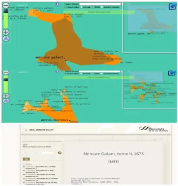
Figure 3 The Memory Islands for the Le Mercure Galant journals. The top image show the islands for all the docu-ments in the website of OBVIL and we can access to the
77
77
3
journal by this visualization. The second island is visualiza-tion of an ontology created by Paris-Sorbonne University with the topics (nearly 1000 topics) of Le Mercure Galant Journals.
Project OBVIL --- Children’s Books
The project Labex OBVIL (l’Observatoire de la vie litté-raire) intends to develop all the resources offered by computer applications to examine both the French litera-ture of the past as more contemporary. It promotes scien-tific research in the field of Digital Humanities. In this paper we will illustrate some examples we did with the Le Mercure Galant journals (Fig.3).
CONCLUSION AND DISCUSSION
In this proposition paper, we have demonstrated some examples we did within Digital Humanities by using Memory Islands. Our technique is taking advantage of the users’ familiarity with interactive map (such as the Google Maps) to help them achieve complex visualiza-tion tasks. The geographic metaphors we designed ena-bled users to have in-depth insight into the given knowledge.
These gave researchers in Digital Humanities seeking for a visualization technique to apply to their work a prelim-inary overview of our technique. We have done a series of users experiments with different techniques applied to different ontologies; we found that our technique gives some advantages for the users without experience in visualization to navigate and remember their ontologies. We hope it would be a worthwhile topic for both infor-mation visualization researchers and scholars in Digital Humanities.
ACKNOWLEDGMENTS
We wish to thank all the interns and participants of the experiment, anonymous reviewers for their helpful comments. This work was supported in part by a grant from the French National Research Project (Investisse-ments d’avenir) LOCUPLETO and this work has been done within the Labex OBVIL project, and received financial state aid managed by the Agence Nationale de la Recherche, as part of the programme "Investissements d'avenir" under the reference ANR-11-IDEX-0004-02".
BIBLIOGRAPHIE
1. Gansner, E., Hu,Y., and Kobourov, S., Chapter: Viewing Abstract Data as Maps, in book: Handbook of Human Centric Visualization, Publisher: Springer, Editors: Weidong Huang, pp.63-92, 2013. 2. Mosallem, Y. Abi-Haidar, A. and Ganascia J.G.: Unsupervised
Named Entity Recognition and Disambiguation: An Application to Old French Journals, volume 8557 of the Lecture Notes in Com-puter Science series. In Proceedings of ICDM 2014.St. Peters-burgh, Russia. (2014)
3. Skupin, A., Fabrikant, S. I.: Spatialization methods: A cartographic research agenda for non-geographic information visualization. Car-tography and Geographic Information Science, 30(2), 99−120. (2003)
4. Thorndyke, P., and Hayes-Roth, B. Differences in Spatial Knowledge Acquired from Maps and Navigation. 1982, Academic Press. Cognitive Psychology 14, pp 560-589.
5. Yang, B and Ganascia, J-G,: Memory Islands: an approach to cartographic visualization, In: Classification & visualization: inter-faces to knowledge: proceedings of the International UDC Semi-nar. Edited by Aida Slavic, Almila Akdag Salah, Sylvie Davies. Wurzburg: Ergon Verlag, pp 137-152. (2013)
6. Yang, B and Ganascia, J-G,: Creating knowledge maps using Memory Islands, In: proceedings of Knowledge Maps and Infor-mation Retrieval (KMIR) workshop at ACM/IEEE Digital Librar-ies 2014, London. (2014)