ARTIFICIAL NATURE: Water Infrastructure and Its Experience as Natural Space
byFatma Aslihan Demirtag B.Arch.
Middle East Technical University, 1991 Submitted to the Department of Architecture In Partial Fulfillment of the Requirements for the Degree of
Master of Science in Architecture Studies at the
Massachusetts Institute of Technology June 2000
02000 Fatma Aslihan Demirtag. All rights reserved. The author hereby grants to MIT permission to reproduce
and to distribute publicly paper and electronic copies of this thesis document in whole or in part.
thor Department of Architecture
May 18, 2000
Certified by William L. Porter
Norman B. and Muriel Leventhal Professor of Architecture and Planning Thesis Supervisor
Certified by Sibel Bozdogan
Associate Professor of Architecture Thesis Supervisor
Accepte8 bf Roy Strickland
Principal Research Scientist in Architecture Chairman, Department Committee on Graduate Students
MASSACHUSETTS INSTITUTE OF TECHNOLOGY
JUN 1_2R2000
UIBRARIES
Thesis Reader A. Hashim SarkisA. Hashim Sarkis Associate Professor of Architecture Thesis Reader
ARTIFICIAL NATURE: Water Infrastructure and Its Experience as Natural Space
by
Fatma Aslihan Demirta$
Submitted to the Department of Architecture on May 18, 2000 in Partial Fulfillment of the Requirements for the Degree of Master of Science in Architecture Studies
ABSTRACT
This work is about water infrastructure and its experience as urban and natural space. It deals with the concepts of nature/geography, technology, and the integral experiential space by analyzing water dams and reservoirs that are more than utilitarian structures. These structures at the same embody a space of imagination that unfolds into idealized geographies and nature's in their experience. In the process of formulating the concept of ARTIFICIAL NATURE, an expanded
definition of 'built activity' is pursued to embrace landscape/nature, infrastructure, and technology as well as imaginative and mental space. The specific sites of investigation range from Thrace to Central and Southeastern Anatolia in Turkey from 1920-2000.
Thesis Supervisor: William L. Porter
Title: Norman B. and Muriel Leventhal Professor of Architecture and Planning Thesis Supervisor: Sibel Bozdogan
Acknowledgements
My first 'thanks' goes to the Program for Islamic Architecture at MIT for their numerous
supports throughout my research including the Aga KhanTravel Grant. I would like to thank,
Sibel Bozdogan for being my initial source of inspiration as well as for her creative thinking and vast generosity,
William L. Porter for his wonderful shocking questions,
Hashim Sarkis for his 'Green Modern' class which made a difference.
I am very grateful to the State Water Works of Turkey (DSI), Istanbul Wakf Waters
Directorate of ISKI, Oral Onur from Edirne and METU for sharing their Gazi Model Farm study and my old friend Figen Isik for discovering it for me.
My friends and colleagues have been of enormous help. Thank you Janna for editing my
'drafts' so many times and more so for being a wonderful friend. I have to thank Heather for her friendship, optimism and her worldview, her presence was the most pleasant
support. My wise and young friend Mine, thank you so much for valuing my work and for sharing my Cambridge years. I would also like to thank Maura for the morning coffees and her warm heart, it made all the difference.
Without my parents this work would really have been impossible. Especially my father who worked as my 'research assistant'. I thank them for their strong belief in me and my work, and also for being my lovely friends. My grandfather and grandmother have always taken great pride in my profession, this work is dedicated to them. My last but not the least thanks goes to my 'life long partner' Alper for his patience and love without whom this process, as well as life, would have been very hard.
CONTENTS
INTRODUCTION: Spaces & Frameworks 7
I Land and Nature 12
1 Literary Sources: "These Anatolian landscapes are mute..." 12
2 Idea of Soil and Agriculture: Gazi Model Farms 15
a Ideas, and Reports
b 'Sword and Plough' 19
I Trans-planting Geography and Memory 21
1 Creating 'Instances' of Istanbul in Ankara 25
a 'Beaches of Ankara': Gazi Model Farm reservoirs 27
b 'Bosphorus of Ankara':
Qubuk
Dam 33c The 'Lake': Youth Park 43
d 'Islands' 45
2 Ritual: Kayzks and swimming 47
III ARTIFICIAL NATURE 52
1 artificial NATURE: the "Sea" of the Southeast 54
2 ARTIFICIAL nature: Re-anchoring Machines 55
a Narration: Writings in the Landscape 57
b Space and ritual 61
-'Water Sports Festival' and the 'Harvest Festivities' -The colorful dynamites
c From the Sublime Porte to The Sublime Land 64
-Sanctified Space
EPILOGUE: In-between Categories and Space of Imagination 68
Illustrations 69
Appendix A 143
Appendix B 145
Appendix C 149
Landscapes can be deceptive.
Sometimes a landscape seems to be less a setting for the life of its inhabitants than a curtain behind which their struggles, achievements and accidents take place. For those who, with the inhabitants, are behind the curtains, landmarks are no longer geographical but also biographical and personal.
J. Berger, A Fortunate Man, 19761
The ship is the heterotopia par excellence. In civilizations without boats, dreams dry up, espionage takes place of adventure, and the police take place of the pirates.
M. Foucault, "Of Other Spaces", 19862
INTRODUCTION: Spaces & frameworks
Think of a valley encircled by mountains in the midst of which stands a rocky hill that is enveloped by a walled city. (figs. 1, 2) Brown and ochre are the dominant colors in this geography, for the plateau onto which the city overlooks is covered with a layer of brown earth mostly of limestone. This brown soil is agriculturally very infertile because of the volcanic and limestone material it contains. The ochre color is of the steppe3 that is the predominant flora of the region, which is dry for most of the year except during
downfalls of rain. Rain and snow scarcely falls onto this province with the annual average of 367 mm. of rain and 14 days of snow. In short the climate is an arid one. Dust storms constitute a major disadvantage. The summers are hot, winters are cold, and the 1 Berger, J., A Fortunate Man, London: Writers and Readers, 1976, p.13-15
temperature difference between day and night can go up to 24'C. The most important water resource is the Ankara Stream which consists of Qubuk, Incesu and Hatip Creeks. The flow of these rivers is very unstable and weak, as it is well expressed in the name of the Incesu creek which literally means 'thin water'. The place I have been describing is Ankara just before it became the capital of the Turkish Republic that was established in
1923. It is a typical inland, arid Central Anatolian city, situated approximately at the
center of the Anatolian Peninsula.
Despite the aridness of the region, 1930's newspapers were full of references, celebrating Ankara's new, public "sea" and "shores" as "modem recreational spaces of the new
capital."4
Considering the natural and geographical qualities of Ankara which are usually summarized as 'arid, drought-ridden steppes,' a geographical term such as 'shore'-not just shore, but a new shore, sounds very ambitious as well as surreal. The peculiarity of the situation increases as one discovers that the containers of the 'seas' are in fact, man-made elements of infrastructure: the reservoirs of the Gazi Model Farm, The
Qubuk
Dam and the Youth Park Lake, constructed roughly between 1925-1935.The present work emerged out of a curious venture into the seemingly surreal 'shores' and 'seas' of Ankara and a personal/professional affinity to infrastructural works-with a special accentuation on water infrastructures. What particularly triggered this project was the coexistence of otherwise distinct and different spaces-such as natural space,
infrastructural or technological space, architectural space and imaginary/memory space-in a sspace-ingle place. Interestspace-ingly one discovers about these spaces that there were many different ways to perceive and refer to these spaces as well as distinctive fashions to live and imagine them. As it will be evident in the discussion of these spaces throughout the text, the terms that denote these structures show a variety such as: water bodies,
infrastructural constructions, shores, seas, reservoirs, (artificial) nature or technological icon. Thus a deepIn sigation into these particular will make it possible to question and elaborate on issues of nature, infrastructure (technology) and imagination (memory and prospect) and their place in the process of space making. Such an investigation poses 3 Steppe: A semiarid grassland.
many questions. For instance it demands the clarification of and the relationship between terms such as natural and technological-an exploration that constitutes the underlying premise of my study. I have largely benefited from the writings of Raymond Williams, Leo Marx, William Cronon and David Nye which investigate conceptions of 'nature' and technology5 and questions our received notions about these categories.
More specifically, an inquiry of the constructions that were referred to as 'shores' or 'seas' bring forward issues that challenges the conceptions and conventions of space making. The juxtaposition of spaces that are considered to be by definition incompatible such as utilitarian (merely functional) and imaginative is considered to be an exception and is not a common practice. Viewing of spaces that can be characterized by polar opposites, such as utilitarian versus fantasy, as odd and exceptional is due to the strict
compartmentalization in the institutionalization of building activity in general. These binary categorizations have become so autonomous and entrenched in our modem way of thinking that any trading amongst them has become hardly possible. The spaces that constitute the subject matter of this study are infrastructural and utilitarian constructions, containing significant bodies of water. Yet these bodies of water overlap with another space of a totally different program and raison-d'atre, which is the imaginative space created by formal expressions, enactment, rituals, and metaphors. For example, a reservoir that is referred to as "the Marmara Sea" and experienced as such, portrays an overlapping of contradictory spaces-utilitarian (since it is a reservoir for irrigation) and imaginary (for this space is connected to a distant place and its memory with imagination and the similar existence of a substance, i.e., water). The binary opposition between the utilitarian and the imaginary needs to be questioned and blurred. Michel Foucault formulates the most eloquent description of such hard to categorize spaces in his article
"Of Other Spaces"6 in which he defines heterotopias as effectively enacted utopias. In other words, these spaces are real, unlike utopian space, where all the sites are
represented, contested and inverted simultaneously: "The heterotooA apable of 5 These main texts are: Williams, R. The County and the City, New York: Oxford University Press, 1973; Cronon, W. Uncommon Ground: Toward Reinventing Nature, New York: W.W. Norton & Co., 1995; Marx, L. The Machine in the Garden; Technology and the Pastoral Ideal in America, London; New York: Oxford University Press, 1967 and Nye, D., Technologies of Landscape-From Reaping to Recycling, Amherst: University of Massachusetts Press, 1999, p. 3
juxtaposing in a single real place several spaces, several sites that are in themselves incompatible."7 However, it must be clear that the concept of heterotopia, while substituting a perfect analogy to the subject matter spaces in a descriptive level, is not central to this study.
Building of infrastructural spaces that are entertained as public spaces is an activity that has historical precedents in the Ottoman Empire where the architectural activity was not divorced from the construction of the infrastructure until the profession was modernized in the 20 century. Water dams existed in the Ottoman Istanbul since 16' century and their design revealed that they were spaces of ceremonies and leisure. At certain moments of this study I will try to trace the path of infrastructure in the bifurcated practice of the Ottoman Imar9 tradition. While doing this I will propose a way of looking
at contemporary examples of man-made water bodies such as the recent Southeastern Anatolia Project (Giineydogu Anadolu Projesi) through this lens that can perceive infrastructural construction in a historical perspective. The Southeastern Anatolian Project (GAP hereafter) is seldom conceived in terms of its architectural/landscape and instead, widely and almost solely discussed in terms of its political-ecological
repercussions.' A discussion of mere political and ethical points of view reduces a physical and a cultural phenomenon to a dimensionless entity that is by no means
illuminating in a debate that is about space and form. "Any attempt to use such codes as a means of deciphering social space must surely reduce that space itself to the status of a
6 Foucault, M., 1986.
7 Foucault, M., "Of Other Spaces", Diacritics 16-1, Spring 1986, p. 263
8 For a comprehensive discussion of water infrastructure in the Ottoman Empire see article in Appendix C.
9 Imar means development and constitutes the root of the word mimar, that is architect. Also more significant is the word muhandis that was used before mimar and which means engineer.
10 The discussions about the Southeastern Anatolian Project focus highly on the issues of minorities and international water rights. The former debate is about the Kurdish conflict that prevails in Southeast Anatolia in many levels. The problem addressed in this specific case is displacement of the minorities. The latter problem is between Syria and Iraq, who are the
downstream countries of the rivers Euphrates and Tigris. The construction of the dams reduces the normal flow of the rivers at certain periods. Turkey claims that the river flow is very irregular and
by way of these dams the droughts are prevented for all of the three countries. For extensive
message, and the inhabiting of it to the status of a reading."" Although I will be using this methodology that takes language as a model where necessary, my argumentation will
in no way adapt it as the only approach. Experiences have shown that despite the common appreciation of the formal and physical attributes of, for instance the Atattirk Dam, the major discussion cannot get beyond-even in architectural circles, what I would like to call 'media sustained intellectualism.' The latter takes its sources of argumentation mostly from political discussions that appear in popular media and do not concentrate on the physicalities of the subject at all-which actually is very hard to ignore considering its scale. Relevantly I will be dealing with the substitution of the Sublime Porte , i.e. the Ottoman Empire, with the technological and natural sublime power of the land that becomes symbolized in the mentioned contemporary examples.
The framework I propose aims at to widen the territories of architecture to contain infrastructure and landscape to establish a 'building activity' at large that can "embrace urbanism, infrastructure, strategic planning, and speculative ideas alongside the more familiar themes of nature and environment,"3 as James Corner puts it. While the case study will be specific to a certain space and time, Turkey 1920-2000, the theoretical discussion will address wider architectural and landscape questions and problems. However, this discussion will accommodate and analyze in depth the idiosyncrasies, nuances and peculiarities pertaining to the specificities of context not excluding the biographical and personal aspects of these geographical landmarks.
" Lefebvre, H., The Production of Space, Oxford, UK ; Cambridge, Mass., USA : Blackwell,
1991,p.7
12 Sublime Porte was the name used by the Europeans to refer to the Ottoman Empire. It is Bab-i Ali in the Ottoman language, which is the name of the last gate in the Topkapi Palace (the imperial
palace in Istanbul) leading to the Sultan's court.
13 Corner, J. Recovering Landscape- Essays in Contemporary Landscape Architecture, New York: Princeton Architectural Press, 1999, p5
I Land and Nature
1 Literary sources14
: "These Anatolian landscapes are mute..."
"I know well that what I am looking for is not these people themselves nor the times they have lived in... No, it is certain that we don't like things past for themselves. What attracts us to them is the void that they have left behind. Whether there is a visible trace or not, in our inner struggles, we search for our lost parts in them."5
So writes Ahmet Hamdi Tanpinar, a prominent Turkish author/novelist, in his book Be
Sehir.
Void and suspense-related to landscape, appear to be the common state of mind for the period, as revealed by a quick analysis of the literary sources of the time period. To quote from Yakup Kadri Karaosmanoglu, another author who has actively lived through the establishment of the new regime, writes in his book Ankara, through the voice of a bureaucrat:"It is as if I am suspended in the void here. I don't touch the ground at any point. There is such a distance between me and these trees, these rocks that I cannot surpass and
touch... It is as if this world is offended by me, and I, am hurt. Besides, these Anatolian landscapes have no language."1 6
4 It is hard not to agree with Lefebvre where he asserts "the problem is that any search for space in literary texts will find it everywhere and in every guise: enclosed, described, projected, dreamt of, speculated about." in Lefebvre, H. 1998, p.15. I will be using literature as one of my sources precisely for the same reason it constitutes a problem in a general theory of space: to find out and analyze the projections, speculations and dreams as 'mental and imaginative constituent' in the material production of the spaces. However, I must also note that the these sources primarily those of the (Istanbul( elite and the literati, not always reflecting the sentiments of the entire population. 1 Tanpinar, A. H., Bes Sehir. Istanbul: MEB Yayinlari, 1992, p. 256-258. Trans. mine. "Iyi biliyorum ki aradigim sey bu insanlarin kendileri degildir; ne de yasadiklari devre hasret cekiyorum... Hayir, aradigim sey ne onlar, ne de zamanlaridir.. .Hayir, muhakkak ki bu eski seyleri kendileri icin sevmiyoruz. Bizi onlara dogru ceken biraktiklari boslugun kendisidir. Ortada izi bulunsun bulunmasin, icimizdeki didismede kayip oldugunu sandigimiz bir tarafimizi onlarda ariyoruz."
16 Karaosmanoglu, Y.K. Ankara, Istanbul:Iletisim Yayinlari, 1998, p.87. Trans.mine. "Burada
adeta muallakta duruyorum. Hic bir tarafimdan topraga dokunmuyorum. Bu agaclar, bu taslarla benim aramda oyle bir uzaklik var ki, bir turlu gecip onlara yetisemiyorum... Sanki bu alem bana kus, ben de ona dargin gibiyim. Hem, bu Anadolu peyzajlarinin dili yok."
These literary topos, that depict the feeling of void, suspense and alienation, draw their mood largely from landscape, land and the surroundings. Yakup Kadri Karaosmanoglu continues, "These places must have a language but we don't understand it."17 The same land, the same geography seems to have been suddenly charged with an alien character or de-charged of its familiar aspects. "Not touching the ground" implies the sense of
rootlessness that is prevailing as an outcome of the newly established (or-to-be-established) identity, which is projected onto the landscape.
Such literary accounts are those of the Istanbul elite and bureaucrats who talk about Anatolia and principally Ankara. Most of the government bureaucrats who moved from Istanbul to the new capital found it hard to adapt to the new landscape. That is why rootlessness and alienation plays into the accounts. They are outsiders in this landscape, thus not integrated, suggesting an insider-outsider conflict articulated by Cosgrove:
"Herein is a clue to the status of the landscape concept. The visible forms and their harmonious integration to the eye may indeed be a constituent part of people's
relationship with the surroundings of their lives, but such considerations are subservient to other aspects of a working life with family and community. The composition of their landscape is much more integrated and inclusive with the diurnal course of life's
events-with birth, death, festival, tragedy-all the occurrences that lock together human time and place. For the insider there is no clear separation of self from scene, subject from object. There is, rather, a fused, unsophisticated and social meaning embodied in the milieu... (The insider) is... an 'existential insider' for whom what we may call landscape is a dimension of existence, collectively produced, lived and maintained." 8
Tanpinar acknowledges the relation of nature and landscape with the collective
imagination of the people: "Nature is a frame, is a stage. Our longings enable us to fill it with our own actors and atmosphere. However this elixir may be delicious or its effects
17 ibid., p.87
18 Cosgrove, D., Social Formation and Symbolic Landscape, Totowa, New Jersey: Barnes & Noble Books, 1984, p.19.
strong, it cannot overshadow the fact that Turkish Society is standing on the threshold of a new life."19
This threshold condition will lead to the concept and mechanism of re-anchoring, which I will deal with in the third chapter.
19 Tanpinar, A. H., Bes Sehir. Istanbul: MEB Yayinlari, 1992, p. 259. Trans. mine. "Tabiat bir cerceve, bir sahnedir. Bu hasret onu kendi aktorlerimizle ve havamizla doldurmamizi mumkun kilar. Fakat bu icki ne kadar lezzetli, tesirleri ne kadar derin olursa olsun Turk cemiyetinin yeni bir hayatin esiginde oldugunu unutturamaz."
2 Idea of Soil and Agriculture: Gazi Model Farms
a Ideas, Reports
The Ankara Gazi Model farm was the first of the several model farms developed in the country in the 20's and 30's. (figs. 3, 4) The enterprise was initially a private attempt of Ataturk. The dynamics at work in this case were dependent on Atatirk's own set of
individual thoughts. Later in 1933 Atattirk bequeathed this complex as well as the other five similar Gazi Farms to the State. Among the writers Atattrk read and cited in many occasions was Rousseau who seems to have significant impact on his thinking. Of the Rousseau literature we have concrete evidence that Social Contract was in his reading
list.20 Ataturk's beliefs regarding agriculture and land as the roots of the new State
resonate with Rousseau's thoughts on Nature in the Social Contract. In addition to the relation established through laboring the nature in the Book I called "The Property" Rousseau offers precepts claiming a territory and its rules. Third rule reads: "...he takes possession, not by an idle ceremony, but by actually working and cultivating the soil-the only sign of ownership which need be respected by osoil-ther people in soil-the absence of a legal title."
The parallel with this line of thought in Atatirk is quite fascinating. In a 1923 speech Atattirk said:
"There are two instruments of conquest in the world. One is the sword and the other, the plough. I have repeated elsewhere and find it necessary to repeat again.
A nation whose only instrument of victory remains to be the sword would
eventually get expelled, humiliated and would become wretched and ruined. The tragedy of these nations may even amount to being enslaved in their own country. For this reason the real conquest is the one not just done by the sword but also with the plough. Plough is the device to progress nations in their lands, it is not like sword. The more it is used the more powerful it becomes. The arm that
20 Tufekci, G. (ed.) Ataturk'un Okudugu Kitaplar, Ankara: Is Bankasi Yayinlari, 1983, p. 396-398
uses the sword is apt to get exhausted but the one that uses the plough becomes the possessor of the soil. The sword and the plough. The former has always been defeated by the latter..."2
Rousseau constructs a relation between climate and form of governing where climate also determines the characteristics of the people. He states that the ethos of the people and the nature of their State are directly related to the fertility of land. In this interpretation, the
alienation people feel in their new landscapes becomes more understandable. Nature plays almost the fundamental role in the construction of the society: "Freedom is not a fruit of every climate, and it is not therefore within the capacity of every people. The more one reflects on this doctrine of Montesquieu, the more one is conscious of its truth."2 He adds,
"Thus in every climate there are natural factors on the basis of which one can determine the form of government to which that climate leads; and we can say what sorts of inhabitants each must have... Mean and sterile places, where the product does not repay the labour, must remain uncultivated and deserted, or peopled only by savages. Places which yield only the bare necessities of men's lives must be inhabited by barbarous peoples, since no political society is possible. Places where the surplus of product over labour is moderate are suited to free peoples..."24
The steppes, where Ankara, the new capital was situated, are arid and thus infertile lands in the agricultural sense. In Rousseauian terms, Ankara does not show the characteristics of the climate of the free people. The primary importance given to the cultivation of the soil and greenification of the capital with the hydraulic engineering and modern farming projects can therefore be seen as an effort to transform its nature to fit the norms of the landscape of a democratic government as envisioned by Rousseau. Climatic reports seem 2 From the speech given by Ataturk to the farmers of Adana in 16, 3, 1923 quoted in Ataturk ve Tarim, Ankara: Tarim ve Orman Bakanligi-Ankara Ziraat Fakultesi, 1981, p. 19. The same 'sword and plough' motto is repeated in various speeches such as in 17, 2, 1923 in Izmir Economy Congress in the same source.
to be of paramount importance in those days capable of stirring some debate about the location of the capital. The reports were used for the justification and legitimization of the location of the capital which was many claimed to be arid, poor and inappropriate to live. One argument tried to prove that the climate in Ankara was actually not of a steppe and that the natural aspects of the location are suited for a city to prosper. As cited by Halit Rifki Atay in his memoirs, these reports delineated the same climate-determined relations between people as well:
"...This (Ankara) is a plateau and on this high platform most rich civilizations have been born and prospered. Because the climate in this plateau is a male climate. Annual averages of temperature do not show big differences... Professor of Climatologie et Hydrologie Therapetique Mr. Piery, in his oeuvre Traite de Climatologie Biologie et Medicale states despite the fact that he considers the climate a steppe-which is a wrong assumption-he explains the abundance of the factors here that enable the establishment a civilization: 'This climate is a unique school to train souls to endure difficulties. People here have adopted it as a moral to fight the rebelliousness of nature. They can adapt to the most hot and most cold weather. This climate develops the ability of initiatives and moral
,,25 energy...
The idea that technology is a masculine act on nature, (the latter typically personified as female)26 can be challenged in the case of Ankara, especially in
Cubuk
Dam and the reservoirs. Considering the reports that refer to Ankara's climate and flora as a 'male' climate, the introduction of artificial lakes and thus the greenification, which is an act of technology, may well be regarded as the 'feminization' of a 'masculine' nature. Likewise 'earth' and 'land' in Turkey are referred to as 'Mother Earth' and 'Motherland.'27 In its Turkish adaptation Anatolia becomes Anadolu which means "land of mothers". The view that pairs the irrational, the untamed and the uncultivated nature with femaleness is 24 ibid., p.12525
Atay. F. R. Cankaya, Istanbul: Dogan Kardes, 1969, pp. 356-359. (italics mine)
26 For representation of nature as female in Western mythology, literature and culture see
Merchant, C., Death of Nature: Women, Ecology, and the Scientific Revolution, San Francisco: Harper & Row, 1983.
reversed where the initial surrounding is perceived to be male to begin with.
Correspondingly the use of technology not to dominate nature itself but on the contrary to recreate and redeem nature is much more complex in this specific context than the theories that condemn modern technology as aggression toward nature.
The report cited above continues to try to prove that the climate here is not of a steppe according to international humidity standards. However, Prof. Piery adds that medical science advises the increase of the humidity of inland cities, especially those which are located high up in the plateaus, to decrease the possibilities of health related problems. The report ends by stating that lack of trees is the primary deficiency in this locality since trees are much-needed repositories of humidity. The Gazi State farm acts as an agent to resolve these problems of climatological deficiencies of the capital along with developing modern techniques in agriculture. It is not mere coincidence that the architect who constructed the Marmara Kiosk (residence for Atattirk), the Brewery, the siedlungs for the brewery workers and a hamam (Turkish Bath) in the Gazi farm, Ernst Egli2 8 precisely
talks about similar issues in his book Climate and Town Districts-Consequences and Demands.29
Like Rousseau, Egli also supports the direct relation between climate and people, and goes further ahead classifying the regions that share the same climate in the world.
27 In Turkish: Toprak Ana and Anavatan.
28 Ernst Egli got his architectural degree from Vienna Technical University in 1918. Among his professors was Fabiani. Around 1922 he becomes known as Siedlung builder. During his stay in Turkey he collaborates with ETH in Zurich, where eventually he settles. In his book there are abundant references to Switzerland more than anything and despite his German connections he seems to sympathize with French-Swiss line of thought with regards to nature. His buildings for the sake of this paper have been left out since the discussion of every built aspect of the State farm exceeded the limits of a study of such a scale. For the purpose of the paper his buildings have remained rather not so relevant and even insignificant. However, the intention remains to make a detailed analysis of the Farm buildings as part of the larger project. For a brief account of Egli's work in Turkey look at Nicolai, B. Moderne und Exil, Berlin: Verlag fur Bauwesen, 1998, pp.20-42.
29Egli, E. Die Neue Stadt in Landschaft und Klima- Climate and Town Districts Consequences
c 'Sword and Plough'
In 1935 Ataturk addressed the farmers of the new nation as follows, "Our country is the country of two things: farmers and soldiers. We are a nation that trains very good farmers and soldiers. We have produced good farmers for we have vast lands. We have produced good soldiers for we have numerous enemies envying those lands. You are the ones that both plough and protect the land."30
The "sword and plough"3 1 motto introduced by Atatfirk takes on an interesting path if we observe that agriculture or the cultivation of the soil takes on a militaristic quality with the analogy of 'instrument of conquest'.
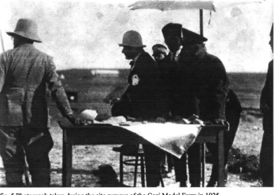
In fact the first photographs of the farm site with Atatirk and the research team testifies to the spirit of this project of 'conquest' at its inception. They look like reconnaissance troops. (figs. 5, 6) The farmer-soldier motif is not unique to Turkey at the time. Golan in his book Modernity and Nostalgia, gives an account of France between the two Wars and how the frustration from the war lead France to flee to the countryside and return to Nature. He informs us that peasants were the majority of the population that went to war and died. In return the glorification of agriculture and the peasants was also due to this "presumed victimization of the peasantry in war time." The persona who was both peasant and soldier was Soldat-Laboreur. He also adds that, "the emphasis on the land
as the locus of national identity, it ultimately contributed both to the glorification of those closest to the soil-the French peasantry-and to the denigration of all things urban and industrial, and thereby modern and foreign."33
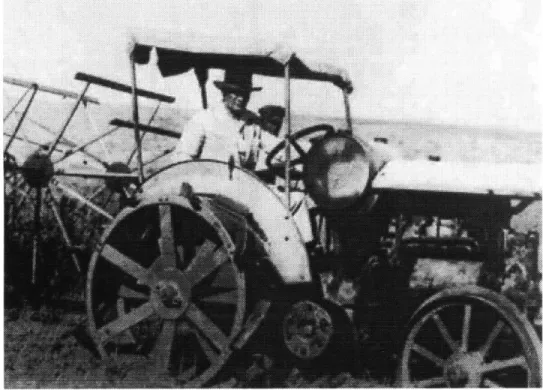
The condition was similar in Turkey. Atatfirk referred to himself as the Master Farmer and Master Soldier, and showed that he was a farmer on every occasion. (fig. 7)
30 Kocaturk, U. Ataturk'un Fikir ve Dusunceleri, Ankara: Ayyildiz Matbaasi, 1971
31 The very same motto is used by Mussolini.: "0 Blackshirts, 0 veterans, the arms of the Nation
must be very strong. For the plough drives the furrow, but the sword defends it... Now you know why you heard the voice of the cannon thunder alongside mine." Cited in Schmidt, C. T. The Plough and the Sword-Labor, Land, and Property in Fascist Italy, New York: AMS press, Inc.
1966.
32 Golan, R. Modernity and Nostalgia, New Haven and London: Yale University Press, 1995
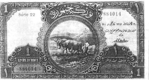
However, instead of refusing everything industrial and urban such as in the French case, a blending of urban-rural qualities was the aspiration in Turkey. The capital became the site where the countryside was brought into the urban setting. The first banknote of the Republic portrays this in pictorial sense. (figs. 8, 9) The currency portrays Ankara, with the citadel at the background and with the first National Assembly. In the foreground a young boy is ploughing the soil. What is most accentuated in this image is the rural activity taking place almost in the front yard of the National Assembly. The capital becomes a place where the village is contained. State farm also illustrates this
understanding where the capital becomes a testing ground for agriculture and the most prominent recreational-public spaces are contained within it.
II. Trans-planting Geography and Memory
In 1923, Ankara had become the new capital of the Turkish Republic that represented itself in opposition to the recent past of its people, namely the Ottoman Empire. The new regime situated its center in the heart of Anatolia-read inland and poor in comparison to the former capital Istanbul-3 5 to move away from the history centered in Istanbul. The decision to establish the new capital in Ankara was the result of a two step process. The first step had been taken when it became the headquarters for the Turkish War of Independence against invading powers at the end of First World War. Ankara was favored since it was geographically close to Western Anatolia where the battle was taking place but at the same time it was relatively remote and secluded for safety. Istanbul had already been occupied and was being controlled by the Allied Forces. Moreover it was a cosmopolitan city in its social structure and pregnant with
conspiracies of different ethnic groups who were supported by external forces, which made it an inappropriate location for a nationalist project.36 After Anatolia consolidated its resistance that initially had started as individual local revolts against the invading forces, Ankara became the symbol and representative of that resistance. This could happen only after Istanbul was identified as 'traitor'. It was not difficult to do that since the Sultan had signed the pact with the Allied occupation forces in 1918 who demanded the division of the Ottoman Empire. The second phase that lead to the decision on Ankara was the declaration of the Turkish Republic as the new regime following the
success of the War of Independence. Seemingly, the plan during the struggle for independence was to eventually re-instate the Sultanate and Istanbul as it's capital. However by the early 1920's Ankara had become prestigious by the role it had played in the struggle for freedom, while Istanbul was charged with the negative connotations of
'collapse' and 'betrayal.'
35 There are numerous references to the fact that the new province-capital was found very inferior to the old seat of government in terms of its climate, nature and geography. The fact that it was a steppe climate-arid and infertile, was highly criticized by the Istanbul governmental elite: "If even trees cannot grow, how would it be possible to raise men?" For reference see Atay, F.R. Cankaya, Istanbul: Dogan Kardes, 1969.
36 Tekeli, I. "Ankara'nin Baskentlik Kararinin Ulkesel Mekan Organizasyonu ve Toplumsal
Yapiya Etkileri Bakimindan Genel Bir Degerlendirmesi" in Batur, E. (ed.) Ankara Ankara, Istanbul: Yapi Kredi Yayinlari, 1994, pp. 143-160.
The change that took place as a result of the abolition of the dynastic Sultanate not only occurred in terms of history and identity but also implied a spatial and geographical dis-placement. The center of gravity of the country shifted into the midst of Anatolia. It is important to note that where the displacement decided to settle-Ankara, was initially chosen for its appropriateness as a military headquarter. With the end of the Turkish War of Independence and the declaration of the Turkish Republic in 1923 the dynamics changed from a state of war into a relatively stable and peaceful condition. So did the definition of Ankara, from headquarters into capital. Before Ankara became the capital of Turkey, the Ottoman city of Angora (Ankara's former name) had been a very small province. The railroad that was constructed in the late 1800's had contributed to its economy significantly and connected it to the rest of Anatolia, yet it had not raised it to the level of a prosperous city.3 7
Ankara during 1920's was described as "a small, sad and dusty province."38 The epic story of the construction of the capital of Ankara involved the re-creation of this "sad" place into a 'new space' which would be cultivated and modernized by the will and power of the young nation. The official manifestation of the new identity of the Republic was a tabula rasa condition, that is starting from scratch. The architecture of the 30's in Ankara, in accordance with the ideology of the State, showed a practice of a 'stylistic modernism' which cleansed the architectural vocabulary from historical/traditional motifs.39 The new architecture operated under the pressure to express the 'new' in terms of visual architectural vocabulary.40 On the other hand, the
37 For the 1 9th century Ankara see Ortayli, I. "19. Yuzyilda Ankara" in Batur, E. (ed.) Ankara Ankara, Istanbul: Yapi Kredi Yayinlari, 1994, pp. 109-119, and Akture, S. 19. YUzyil Sonunda
Anadolu Kenti Mekansal Yapi 6dziimlemesi, Ankara: ODTO Mimarlik Fakfiltesi Basim Igligi,
1981.
38 Araz, N., "Mustafa Kemal'in Ankara'si" in Batur, E. (ed.) Ankara Ankara, Istanbul: Yapi Kredi Yayinlari, 1994,pp. 347.
39The discussion of the concept of modernism in Turkish Architecture is beyond the scopes and limits of this study. I will content myself by stating that the modernism and the search for new remained in visual expressions, without being reflected in production or new spatial inventions. For a very extensive and detailed discussion of this subject see Bozdogan, S. Modernism and Nation-building: Turkish Architectural Culture in the Early Republic, Seattle: University of Washington Press, forthcoming in 2000.
40 The field of landscape in Modern Turkish Architecture is unexplored. The general historiography of Turkish Architecture tends to look at 'buildings' in the conventional sense through a stylistic and formal lens. A critique of this approach has been itirated in Bozdogan, S., forthcoming in 2000. However individual studies on this issue of landscape need still be produced.
practices of landscape and infrastructural activities remained outside the official architectural domain. These practices constituted another domain where the Ministry of Public Works (Nafia Isleri Vekaleti) functioned. The ministry was responsible for
amenities such as railroads, roads, parks, dams and other such structures which can be roughly categorized as 'non-conventional-architectural activities'. I will suggest that the most generative and innovative spatial creations have occurred in this domain since it fell into an area where stylistic architectural concerns were minimal or nonexistent. The programs and spaces that the ministry created, proposed new spatial formulations-such as the reservoirs of the Gazi Model Farm, the Cubuk Dam and the Youth Park that constitute the first part of my study. Since the Ministry of Public Works was operating within the realm of landscape and infrastructure realms, it was involved with the idea of land and nature with all the connotations and connections these could bring. As I have previously elaborated in the Land and Nature chapter a sense of rootlessness and suspense prevailed in the perceptions of land and landscape in early Ankara.41 The affects of World War I which ended with defeat were still physically evident in the landscape where villages and fields were burnt or devastated. The feeling of frustration that the landscape and nature conveyed through the ruins of the war was felt at a deeper and wider level in comparison to the euphoria of victory procured by the success of the War of Independence. The ideological motivation of the new regime that celebrated the breaking away from the past and starting anew was diametrically opposite to the sentiments that the destruction of the war evoked which was indeed a nostalgia for the past.
This difference evolved into a tension between the nostalgia for the conditions before the war (read Istanbul in comparison to Ankara in the condition of building a new capital) and the enthusiasm for the new nation. This moment,42 as David Harvey would call it, points to a "capacity for transformative activity" for "a new imaginary; a new discourse arising out of some peculiar hybrid of others; new rituals or institutional configurations; 41 Of course not so in the rural population for they were not displaced as the elite that moved from Istanbul to Ankara and Anatolia.
42 I am using Harvey's term 'moment', which he uses to "avoid, as far as possible, any sense of prior crystallization of processual activities into 'permanences'-things, entities, clearly bounded
new modes of social relations arising out of their internalized contradictions."43 The Ministry of Public Works precisely worked on these dynamics where it had to tackle with "internalized contradictions," between the longing for the past and the devotion to a new future. As I will demonstrate, the spaces created under these conditions proposed new imaginaries and new rituals. Here it should be emphasized that the 'new
imaginaries' and 'new rituals' emerge out of a process of transformation, which always refers back to an original, i.e., the memory of Istanbul in the case of Ankara. In other words a transformative activity always needs something already existing to operate on. What was going through transformation were "moments of material practice "44 which
were "the sensuous and experiential nexus -the point of bodily being in the world-from which all primary knowledge of the world ultimately derives. But the material practices also instantiate and objectify human desires in the material world, not only through the reproduction of self and bodily being but also through modifications of surrounding environments encompassing everything from microtechnologies of the living and the workplace through to the built forms and created environments of cities, agrarian landscapes, and globally modified the ecosystems."45 Along these lines, the shores and the seas built by the Public Works constitute the imaginations, fantasies and, the desires regarding nature and their materialization in terms of both bodily experience and spatial construction in the wider sense.46 The material practice that emerged from this
internalized contradiction is what I call the 'trans-plantation of geography' that implies the creation of an existing geography in a distant place, that is in concrete terms, re-creating Istanbul in Ankara.
domains, or systems." Harvey, D., Justice, Nature and Geographies of Difference, Cambridge, Mass.: Blackwell Publishers, 1996, p.10 5.
43 Ibid., p. 78.
44 Ibid., p. 79. Italics mine.
41 Ibid., p. 79.
46 The imagination might be of one single authority however the receptivity allows one to think that the public shared the enthusiasm and was welcoming. The analysis of manipulation and utilization by users who are not its makers is of utmost significance and of equal value as intentions. De Certeau illustrates this point with a very clear analogy: as " construction of individual sentences within an established vocabulary" and as "speaking vs language" in De Certeau, M. The Practice of Everyday Life, , Berkeley : University of California Press, 1984.p.xi-xiv
1 Creating 'Instances' of Istanbul in Ankara47
"Se non e vero, e ben trovato."48
The three spaces that were of focal public importance which I will be discussing-the Gazi Model Farm, the Cubuk Dam and the Youth Park-overlap with the only three creeks in the region. The
Qubuk
Creek originates in the northern region of Ankara (the river that will be contained by the Cubuk Dam), while the Incesu traverses the city from south to west (through an area which will become the Gazi Model Farm) and the Hatip creek springs from the Idris Mountains in the East (which will be diverted into the Youth Park in addition to the water brought from the qubuk Dam). What emerged out at these points were spaces where architecture, landscape and infrastructure converged and the geography was transformed and represented different temporalities. By trans-planting geography in the general sense I refer to the application or the creation of a replica of aspecific geographical locale that also contains its historical connotations. More specificifically I refer to the trans-planting of Istanbul. At this point the questions how and why this transplantation was realized becomes important, as well as the identification of what was exactly selected to be represented which was a geography surrounded with
water, with its own patterns of urban practice.
A conventional reading of Turkish architectural history would attest that no such
reference to Istanbul existed in 1930's and that Ankara was created by definition as an opposition to it. I argue and will demonstrate that a re-creation of Istanbul was a 'deep-structure' in the creation of Ankara. It was an invisible deep-structure-that is, it did not visually relate to Istanbul by imitating any architectural or urban aspects of the city but
4 7Allusion to distant geographies--especially to 'shores' and 'banks' or lakes and rivers seems to
be existing since Ankara's establishment. During the visit of Metaksas, Prime Minister of Greece, to Turkey in 1937, an interesting and relevant conversation takes place. Ataturk asserts that the origins of the name 'Ankara' is actually 'Angara' and situates the name on a world map. This geographical origin is Lake Baikal, of which the only outlet is the Angara River, which flows west from the lake into the Yenisey River. There is also another river that is connected called 'Turka' and an island named 'Orkhun'. Not only expanding the capital in almost limitless space all the way to Central Asia, this thesis suggests the combination of the two roots. Asia Minor is connected with Central Asia via this explanation.
replicated it at a more abstract level. At this level what was transplanted as a version of Istanbul were selected natural geographical qualities and the rituals that are embedded in them. It would be against the entire ideology of the new regime to overtly reminisce of the old in the capital of the Turkish Republic in 1930's, where the governing class voluntarily moved to construct a 'brand new' young nation. Hence the existence of water and the related performances were selected to be remembered as I will demonstrate. These structures were also ingeniously translated as technological achievements of the new nation which disguised their nostalgic facet. So the citizens of Ankara were provided with the means to be able to navigate in the 'Marmara Sea' and swim in the 'Black Sea' thanks to the technology that was enabled by the Republic.
48 "If it isn't real (true), it's well invented." Traditional Italian saying cited in Baxter, J., Fellini,
a 'beaches of Ankara': The Reservoirs of the Gazi Model Farm
Founded in 1925 by Ataturk, the Gazi Model Farm had the following objectives: to develop and support advanced techniques in agriculture, to experiment, develop and distribute optimized seeds and samples to the entire nation, to produce modem
agricultural equipment and tools, to transform the flora and fauna of Ankara in to a green one. This particular farm was the central farm among the six other Gazi Farms in the country, all of which were established with the same objectives and ideals stated above.
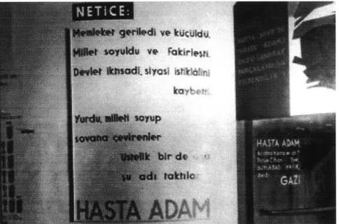
The story of the Gazi Model Farm begins when Ataturk assigned a group of agricultural and soil scientists to survey and prepare a report on the soil conditions of Ankara. Atatiirk, who personally selected the most unfavorable site in Ankara, a marshy and malaria-stricken area, responded to the committee's resistance with the following words, "Who will and who can, if not the nation, ameliorate this site?" Thus the site was determined by Atattirk's personal choice. It is not a coincidence but a deliberate preference that all the other Gazi Farms were built on marshy areas as well. At the foundations of the farm laid the idea of turning marshes into agricultural fields4 9 which metaphorically meant transforming the 'sick man' into a healthy young nation. During its final years, the Europeans referred the Ottoman Empire as the 'Sick Man' of Europe and later the same definition was used by the succeeding Turkish Republic. This connection becomes very clear in the 1934 Exhibition called "Economy Before and After Lausanne", that was held in Ankara. The texts and graphic material in the exhibition narrated the story of the Ottoman Empire slowly proceeding to poverty and collapse. (figs. 10, 11) One of the exhibition panels read: "The country regressed and shrank. The people became poor. The State lost its economical and political independence. The people who
sacked the country also gave him this name: The SICK MAN. Was he really sick? The whole world replied yes. NO, said the leader [Atattirk]."'0 In this bodily analogy, the
49 This was a central trope in other modernization projects like that of Italy under fascism. See Ghirardo, D.Y., Building New Communities : New Deal America and Fascist Italy, Princeton,
N.J.: Princeton University Press, 1989.
50 Illustrated Evren, B. 20'li Yillarin Bozkir Kasabasi Ankara, Istanbul: AD Kitapcilik AS, 1998,
recovery of the nation from sickness is expected to come from agriculture. Not only recovery but also independence was equated with agriculture. Other panels read "The Republic gave us wheat and our independence."" It is significant that forests were also included in this narration of progress and cultivation as the redemption of the arid land: "The steppes are longing for the forest. Love and protect the forest."2 The trees and the fields stood for the physical and visual representation of a cultivated and civilized land. Hence Ankara.
Water became central for this campaign of forestation and agriculture in Ankara since the climate was not at all appropriate for irrigated agriculture that depended on natural cycles of rain. The droughts had frustrated the citizens of Ankara for years. The main economic activity of the city was animal husbandry. The Ankara (Angora) Goat from which the famous Angora Wool was produced had been primary economic resource of the region.3 The only other agricultural production was the cultivation of grape. The vineyards just outside Ankara which were situated higher in altitude were at the same time retreat locations for the elites during the hot and arid summers. The scarcity of
water and the irregular downfall of rain and snow necessitated substantial effort for extensive irrigation. For this reason, the water system was the backbone of this project of green'fication. Thus the water system of the farm, consisting of regulating dykes, canals, dams, conduits, pumps and reservoirs that collected, reserved and distributed the water attained form the available sources was urgently completed in a total of four years. Apart from the fields and forests which were among components, the farm was made up of a brewery that used the wheat grown in the farm, a milk factory, an agricultural tool factory, a zoo, workers houses and a Turkish bath.
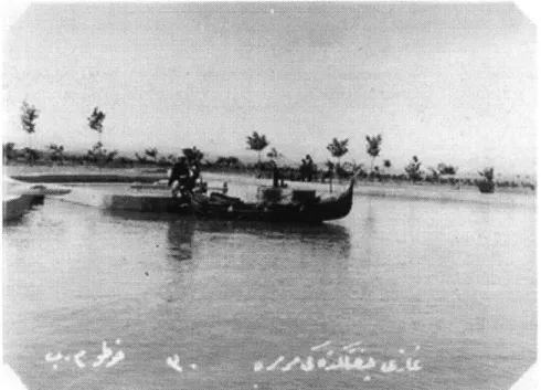
The Marmara Pool (figs. 12, 13, 14) and Black Sea Pool (figs. 15, 16, 17) are the two main reservoirs of the farm's water system, properly sited on the tops of the highest two prominent hills to establish a high water table enabling gravity flow irrigation. The references to the recreational spaces in and around the reservoir pools as the 'Black Sea " ibid., p.64
coasts and beaches' or the Marmara Sea in the popular newspapers of the 1930's are quite fascinating. The newspapers proudly announce that "the citizens need not feel the need of an actual sea shore."5 The water contained in these reservoirs is the underground
water pumped up to the surface and reserved to regularly irrigate the field and part of the forest. Reservoirs are essentially utilitarian structures constructed to store water for controlled and regulated distribution. They are designed as simple containers usually of concrete and with the simplest and easiest-to-build form as possible. The Marmara and Black Sea reservoirs are very particular with regards to this utilitarian aspect in terms of efficiency and diverge significantly from the typical definition and design of a reservoir. The plans of the Black Sea and Marmara Pools exactly replicate the contours of the actual seas they have been named after. (figs. 18, 20, 21, 22, 23) The formations have
been minutely copied-compare with the map (fig. 19)- to such an extreme that, for instance, the islands that actually exist in the Marmara Sea are modeled and built on the reservoirs. Specific enclaves or projections are referred to as 'bays' and 'peninsula's with their corresponding real life district names such as 'Gemlik Bay' (Gemlik Koyu) and
'Kapidag Peninsula' (Kapidagi Yarimadasi).'5 5 In the Black Sea reservoir there is a connected but distinct pool which is called the 'Azak Sea' (Azak Denizi), which actually is the inner sea at the Northern Black Sea to the east of Crimea. The functional and mostly rectangular-or any other shape efficient in terms of construction and material-plan of a reservoir is highly modified to fit in the intricate curvatures and edges of the
shores. These details make it harder and harder to conceive the structures as sole hydraulic works with a supplementary leisure function. Rather, the utilitarian and the recreational functions overlapped. In addition to their primary utilitarian use, the details in the designs of these pools clearly reveal significance as public pools, no less important than their use as reservoirs. These reservoirs/pools clearly embody several overlapped spaces. However the question remains, even though they were also designed as public pools, why did they have to be modeled after 'sea's and particularly why Marmara and Black Sea? This question leads one to think that, in addition to their utilitarian and urban
5 For the textile industry dependent on the Angora wool in Ankara see Kilicbay, M. A. "Sof Sehri
Ankara" in Batur, E.(ed), Ankara Ankara, Istanbul: Yapi Kredi Yayinlari, 1994, pp. 65-72. 14 "Ciftlikte Yaz" , Ulus, Ankara, 28.6.1938
56
recreational function, another level of space was introduced: representational space. Representational space is one of the concepts in the conceptual triad Lefebvre formulates in his discussions of space. These three concepts are:
"1-Spatial practice, which embraces production and reproduction, and the particular locations and spatial sets characteristic of each social formation. Spatial practice ensures continuity and some degree of cohesion. In terms of social space, and of each member of a given society's relationship to that space, this cohesion implies a guaranteed level of competence and a specific level of performance. 2-Representations of space, which are tied to the relations of
production and to the 'order' which those relations impose, and hence to knowledge, to signs, to codes, and to 'frontal' relations. 3- Representational space, Embodying complex symbolisms, sometimes coded, sometimes not, linked to the clandestine or underground side of social life, as also to art (which may come eventually to be defined less as a code of space than as a code of representational spaces)."57
It is "directly lived through its associated images and symbols, and hence the space of 'inhabitants' and 'users,' but also of some artists and perhaps of those, such as a few writers and philosophers, who describe and aspire to do no more than describe... It overlays physical space, making use of its objects."5 8 Although the inclusion of the mental entity into the discussion and conceptualization of space is a breakthrough, I would like to modify this formulation. Representational space does not overlay physical space, the former is embodied in the latter. It does not only make symbolic use of its objects, but the object or more precisely, the physicality of the space already bears these symbolic and imaginary spaces as an integral part of the materialization process. Mental space plays an active role in the creative process of space, since imaginations and symbolisms get transmitted into design and construction. The experience of space than reveals and brings forth this representational space.
56 Lefebvre, H., 1991, p.3 3
" ibid., p.33 58d. p3
The allusion to distant but familiar geographies (read Istanbul) in the construction of reservoirs points to the existence of representational spaces as described above. By the construction of water bodies in Ankara an experience of Istanbul is created at the level of imagination and memory (and also of ritual which will be discussed later), although it is reinterpreted. It is important to note that the seas chosen to be replicated are the ones on which Istanbul has its coasts, not the Aegean nor the Mediterranean. These constructed bodies of water are micro-geographical59 spaces. By micro-geographical space I mean the replication or transplantation of a specific geographical location in a different setting. Although the ideology of the Republic manifested the creation of a new space and of a new history, physical and performative practices continued in a modified configuration. Thus similar to Istanbul, Ankara also had beaches, shores and seas in its geographical setting, which were however, man-made (read Made in Turkey) and technological in comparison to those of Istanbul.
A good example to the transplanted yet transformed space is the kiosk on the edge of the
Marmara reservoir. (fig. 24)This kiosk is a small structure the primary purpose of which is not clear. It is used as a covered extension of the open space during the summer A
1930's photograph of the Marmara pool (fig. 25) shows the little perched on the bank of the pool. The structure cantilevers over the water, accommodating a balcony with a view of the coast across. Although the stylistic and material aspects of the architecture do not offer any conspicuous connection, the experiential qualities of a yali are ever present. Described as "a charming villa perched on the Kapidagi Peninsula in the 'Marmara
Pool,"'6' it stands in one the central spaces of the proud Republican accomplishment.
'Marmara Sea' is complemented with 'Marmara Pavilion' (Marmara Kosku) which overlooks the entire valley on which the farm and the siedlungs, bath, and factories were located. (fig 23) The Marmara Pavilion was often used for receptions and gatherings of the bureaucrats. Designed by Ernst Egli around 1930's it has a portico or eyvan with arches.
59 Here I am inspired by the term micro-climate which also is an outcome in this process of transplantation of geography
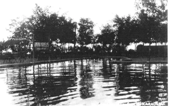
Unlike natural beaches, the periphery of the reservoir-sea is covered with grass. Gemlik Bay is admired for the dark green trees that surround it. Whereas Marmara was shallow thus only navigable. (fig 26) the depth of the Karadeniz reservoir allowed for very high springboards for diving, as shown in the photograph from 1930's. (fig. 27) The end product is not a perfect copy of the original and the motivation is not to exactly replicate. The original is reinterpreted, modified, inverted and turned into a space that is an
amalgam of all the forces that act in its formation. This is why it is not a simulation but a reinterpretation of what ideal nature is and should be-as in all the examples I examine in this thesis and categorize as artificial natures. Such designs are perfect expressions of their moments, containing the technological means and mediums available, historical connections, future projections and local/regional constituents and other peculiarities. As
a result infrastructural facility acts as or substitutes for nature, i.e., becomes what I refer to as 'artificial nature.' It not only transforms nature per se by supplying irrigation and thus greenifying an arid geography but also re-creates the urban practices spatially and ritually.
b 'Bosphorus of Ankara':
Gubuk
DamThe
Qubuk
Dam is the first concrete dam constructed in the history of the Turkish Republic. (fig 28, 29) The contractor, Tahsin Ibrahim, began the construction in May1930 after a year of projecting and negotiating. Tahsin Ibrahim Bey, a graduate of the
Istanbul School of Engineering in 1920 appointed Heiden Berger from Germany as construction manager-who was considered an expert in dam building.62 Geological analyses were done by a 'Mosyo Sapot', Professor of Geology in Istanbul and Dijon Universities.
The discussions about the material and construction technique of the dam during the process of its design and implementation as documented in the State Water Works (DSI)
are quite interesting. The initial design of the dam, which was not executed, was a stone gravity structure. Although in the major monograph about
Qubuk
I Dam, the dams built in the Ottoman Empire are considered to "have become history"- thus not a viable precedent, "since the available constructional information about them is unsatisfactory," it has to be acknowledged that they were all stone constructions.63 The suggestion of this type of construction despite the scarcity of its primary proposed material-stone in the locality, points to the fact that stone construction was proposed because it was the known and conventional method, following the tradition of Istanbul-based dam building.'Mosyo Sapot' later proposes the building of a concrete dam, to avoid the very high cost of transporting of stone from other cities. Also stressed that concrete was the new and advanced technique of the modem era. However, if one were to analyze the
correspondences and documents during the construction of the dam, it becomes obvious that funding was definitely not the motive for concrete construction, for the simple reason
that it was far more expensive than stone. While the idea of a stone dam was discarded for reasons of remoteness to the closest quarry, almost all the raw material for concrete,
62 Cubuk I Baraji, Ankara: DSI Matbaasi, 1971. Written by Bedri Olcer. 63 Ibid., p. 22