comMotion: a context-aware communication system
Natalia Marmasse
B.S., Computer Science
Empire State College, State University of New York, 1995
Submitted to the Program in Media Arts and Sciences, School of Architecture and Planning,
in partial fulfillment of the requirements for the degree of Master of Science in Media Arts and Sciences
at the
Massachusetts Institute of Technology September 1999
© Massachusetts Institute of Technology, 1999 All rights reserved
Author:
Program in Media Arts and Science 28 June 1999
Certified by:
Christopher M. Schmandt
Principal Research Scientist, MIT Media Laboratory Thesis Supervisor
Accepted by: vi Z y . f/ r
Stephen
A Bentn V JChair, Departmental Committee on Graduate Students
Program in Media Arts and Sciences MASSACHUSETTS INSTITUTEOF TECHNOLOGY
OCT 0 1 1999
LIBRARIES
comMotion: a context-aware communication system
Natalia Marmasse
Submitted to the Program in Media Arts and Sciences, School of Architecture and Planning,
on June 28, 1999
in partial fulfillment of the requirements for the degree of Master of Science in Media Arts and Sciences
Abstract
How many times have you gone to the grocery store but left your shopping list on the refrigerator door? Wouldn't it be more efficient to have a reminder to buy groceries and the shopping list delivered to you when you were in the vicinity of the store?
How many times have you suddenly thought of something you must do or have just had a great idea that you want to write down, or record, for future reference? Wouldn't it be useful to record that thought and be reminded of it when in the relevant place and time?
Information delivery utopia would be to receive the exact amount of data we need (no more, no less), when and where we need it, and in a gratifying format, for example, in a pleasant voice or well-structured text. Although we are still far away from this goal, a partial solution to the information overload is to create systems which deliver timely information when the user is in the relevant context.
This thesis describes comMotion, a context-aware communication system for a mobile or wearable computing platform. A behaviour-learning agent automatically learns the salient locations in the user's life. Once these places have been determined, location specific to-do lists, electronic Post-it notes or reminders, and subscription requested information can be delivered to the user at the right place and time. The user interacts with the system through a visual and/or speech interface.
Thesis Supervisor: Christopher M. Schmandt
Thesis Committee
Thesis Supervisor: *1
-Christopher Schmandt Principal Research Scientist MIT Media Laboratory
Thesis Reader:
Dr. Rosalind W. Picard
Associate Professor of Media Arts and Sciences MIT Media Laboratory
Thesis Reader: ,
Dr. Henry Lieberman
Research Scientist MIT Media Laboratory
Preface
Faithful to the essence of my project, I would like to reach people from different contexts. I have tried to explain my ideas simply and comprehensively with the hope that this document will be read by a large community of colleagues and friends from different backgrounds.
People often give an extensive list of all colleagues, personal friends and family they acknowledge. The important people in my private life know who they are. Therefore, I will limit myself to acknowledging only people directly related to this thesis work.
First and foremost I thank my advisor Chris Schmandt who provided me with the opportunity and the environment in which to carry out my research. I thank him also for understanding why I had to be part of the Everest project, although this meant investing most of a semester in work unrelated to our group. At least he can boast having received e-mail from Everest base-camp.
I also wish to thank: Roz Picard and Henry Lieberman for being readers and for their comments and feedback; my colleagues from the Speech Interface Group, Keith Emnett, Stefan Marti, Nitin Sawhney and Sean Wheeler, for support, discussions and feedback; Brad Rhodes for discussions on context-aware issues; Nuria Oliver for discussions and feedback during the development of this project.
And last but not least, a big hug to Isabelle Marmasse my devoted editor.
Natalia Marmasse June, 1999
Table of Contents
1. INTRODUCTION ... ---... 13
1.1 M otivation ...---...---... 13
1.2 System overview ... ... 14
1.3 The plot thickens ... 15
1.4 Terminology ...-...---...- -.. ---... 17
1.4.1 Context-aware, mobile, ubiquitous and wearable computing ... 17
1.4.2 Global Positioning System ... 18
1.4.3 Cellular Digital Packet Data... .. 19
1.4.4 Global System for M obile communication...20
1.5 Speech technology... -... 20
1.5.1 Speech recognition ... 20
1.5.2 Speech synthesis ... 21
1.5.3 Speech technology used in comM otion ... 22
1.6 Document overview ... 24
2. RELATED W ORK ... -. ... 25
2.1 Context-aware systems - indoors... 25
2.1.1 The Active Badge Location System ... 25
2.1.2 Forget-M e-Not ... ... 25
2.1.3 Locust Swarm ... .... 26
2.1.4 C-M ap ...--....-...-.. ---... 26
2.1.5 Activity Server and W atcher ... 26
2.1.6 RadioSpace ... ... 27
2.1.7 The Remembrance Agent ... 27
2.1.8 DyPERS...28
2.2 Context-aware systems - outdoors... 28
2.2.1 CyberGuide and Savoir... .... 28
2.2.2 M etroNaut... ... 29
2.2.3 Stick-e Notes... .... 29
2.2.5 City Guide... 29
2.2.6 Augment-able Reality ... 30
2.3 M obile messaging system s ... 30
2.3.1 Phoneshell... 30
2.3.2 Chatter ... 31
2.3.3 Portico... 31
2.3.4 W ebley ... 31
2.3.5 Nom adic Radio ... 31
2.3.6 Knothole ... 32
2.3.7 Active M essenger ... 32
2.3.8 AT&T PocketNet Service... 33
2.3.9 Ericsson, M otorola and Nokia ... 33
2.3.10 3Com 's Palm VII... 34
2.3.11 GPS and m obile phones... 34
2.3.12 Garmin Navtalk GPS / Cell-phone ... 34
2.4 How comM otion differs ... 35
2.4.1 Time... 35 2.4.2 Place...35 2.4.3 Inform ation ... 36 2.4.4 Behaviour learning ... 36 3. DESIGN ISSUES...37 3.1 W hyspeech ... 37 3.2 Learning ... 38
3.3 Inform ation delivery ... 39
3.3.1 Notifications ... 39 3.3.2 Interfaces... 40 3.3.3 M odes ... 40 3.3.4 Interaction ... 41 3.4 Privacy...41 3.5 Precision of position... 42 3.6 Hardware ... 44
4. AR CH ITECTURE ...
47
4.1 The behaviour-learning agent... 49
4.2 M essage engine ... 51
4.3
Query
engine ...--- ...---.-... 535. COMMOTION CLIENT INTERFACE DESIGN ... 55
5.1 Behaviour-learning m odule... 55
5.2 To-do lists...57
5.3 Rem inders...60
5.4 M ap m odule... . ---... 62
5.5 Inform ation services ... 63
5.6 Query m odule...65
5.7 Speech UI...--. .. ---... 66
6. CO N CLU SIO N S ...--- .. . ---... 69
6.1 Evaluation...69
6.1.1 Location learning... 69
6.1.2 Inform ation delivery ... 69
6.2 Contribution ... .... -... 72
6.3 Future w ork ... ... 73
6.3.1 Short-term ...- ... ---... 73
6.3.2 Long-term ... 74
APPENDIX A - COLOUR PLATES...77
Table of Figures
Figure 1.1: GPS triangulation from three satellites, showing how position is narrowed
dow n to tw o points... 19
Figure 1.2: Architecture of a speech recognizer... 21
Table 1: Dialogue between comMotion (CM) and the user showing the different speech technologies em ployed... .. ... 23
Figure 2.1: The ParcTab personal digital assistant (PDA)... 26
Figure 2.2: The RadioSpace Web-based dynamic map showing users' physical location...27
Figure 2.3: The DyPERS system ... 28
Figure 2.4: Nortel's Soundbeam Neckset wireless telephone, adapted for Nomadic Radio... 32
Figure 2.5: The Motorola PageWriter 2000 ... 32
Figure 2.6: A PalmPilot with a Minstrel 19.2 Kbps wireless IP modem... 33
Figure 2.7: The Nokia 9000il Communicator with personal organizer, fax capabilities, data and m essaging services ... 33
Figure 2.8: The Garmin Navtalk GPS / Cellular Phone ... 34
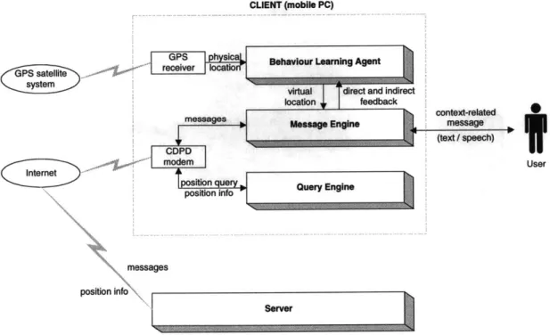
Figure 4.1: Hardware components of the comMotion system* ... 47
Figure 4.2: The architecture of comMotion showing the three main modules of the client application and its connection to the server... 48
Figure 4.3: GPS data showing how signal is lost when arriving at a building ... 50
Figure 4.4: GPS data showing how signal was acquired only several minutes after departing from a building... 50
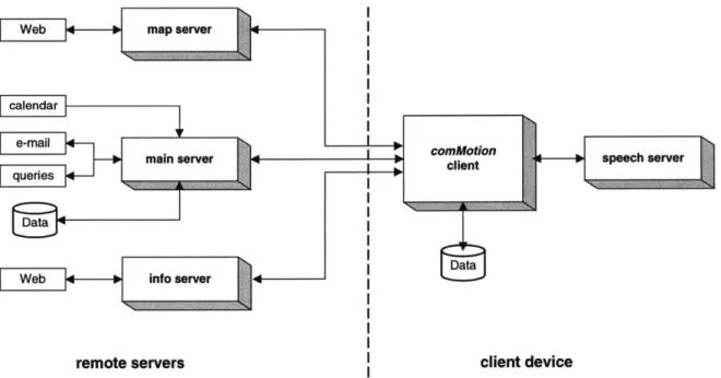
Figure 4.5: Map showing distance between location of departure (Media Lab, on Ames St) and location where identified by the GPS receiver (part way across campus, the grey area)*... 5 1 Figure 4.6: Detailed client-server architecture showing the different local and remote server processes and their communication with the comMotion client application... ...-- 52
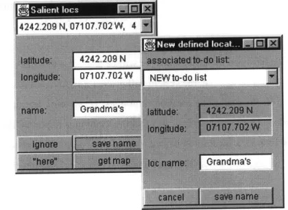
Figure 5.1: Visual interface components used to name a virtual location...55
Figure 5.2: Visual interface components used to see a salient location on a map and tag it w ith a virtual location nam e*... 57
Figure 5.4: Visual interface component used to record audio to-do items ... 59
Table 2: Dialogue between comMotion (CM) and the user showing how audio to-do items are recorded using speech commands ... 59
Figure 5.5: Visual interface component to view and scan reminders*...60
Figure 5.6: Visual interface component used to create a new reminder...61
Table 3: Examples of context-aware e-mail messages... 62
Figure 5.7: List of eight closest requested locales, shown on accompanying map* ... 63
Figure 5.8: Map indicating current location and eight closest requested locales*...63
Figure 5.9: Visual component displaying headline news ... 64
Figure 5.10: Interface component used to subscribe to location-based content information ... 64
Figure 5.11: Visual interface component used to query the whereabouts of another user...65
Table 4: Speech commands supported by the system ... 67
1. Introduction
1.1 Motivation
How many times have you gone to the grocery store but left your shopping list on the refrigerator door? Wouldn't it be more efficient to have a reminder to buy groceries and the shopping list delivered to you when you were in the vicinity of the store?
How many times have you suddenly thought of something you must do or have just had a great idea that you want to write down, or record, for future reference but were unable to? Wouldn't it be useful to record that thought and be reminded of it when in the relevant place and time?
Personal computers have not really lived up to their name: most of them sit on desktops where their interaction with the user is limited to a small part of the day. Over recent years, the trend has been to make smaller and faster PCs in the form of laptops and Personal Digital Assistants (PDAs), consequently making computers more mobile. The main function of the PDAs has been day-planners, notebooks and address books.
Moreover, we live in a world in which the information overload is part of our daily life. Information delivery utopia would be to receive the exact amount of data we need (no more, no less), when and where we need it, and in a gratifying format, for example, in a pleasant voice or well-structured text. Although we are still far away from this goal, a partial solution to the overload is to create systems which deliver timely information when the user is in the relevant context [1], taking into account his mobility.
The ideal personal device would understand you, that is, have a model of you. It would know your context from unobtrusive monitoring sensors and it could combine this knowledge to make the right decisions and present you with required information. You could communicate with it via a multi-modal interface but its dialogue would be context sensitive, for example, choosing speech if it knew you were in a hands and/or eyes busy situation.
Imagine you had a device which always knew where you were and learned about the important locations in your life. Imagine a device which would not only provide specific information upon request, but also proactively remind you of items on your relevant to-do list, pending electronic reminders or other associated information. This data might be text or recorded audio, the output of
which could be visual and/or speech. Not only would you receive the appropriate information where needed but you could also type or record reminders and associate them with specific locations.
1.2 System overview
comMotion is a context-aware, mobile or wearable (depending on the hardware used) communication
system. Emphasis is put on the mobility of the user and his context rather than on the mobility of the computer. Knowing where people are is the key to building location-aware applications. The ideal sensor for such a system would provide location information seamlessly both in- and outdoors. Currently such a sensor is not available, at least not at an affordable price. Therefore this version of
comMotion focuses exclusively on outdoor tracking.
A behaviour-learning agent, using data from the Global Positioning System, tracks the user and progressively learns the frequented locations in his life. Once a salient location has been identified, the user only has to name it or indicate that it is to be ignored. Naming or defining a place converts it into a virtual location, for instance "home", as opposed to its physical, geographic, coordinates. No boot-strapping is required; the agent monitors the user and progressively learns on its own, hence relieving him from the tedious task of classifying data or filling out preliminary forms.
A to-do list is associated with each defined virtual location. These lists resemble their real world paper parallel, on which items are listed and can be ticked off once they have been done. However, in
comMotion, the to-do items can be either text or recorded audio. When the user is in the relevant
location, he will hear an auditory cue alerting him that he has items on the associated to-do list. Moreover, other users can also send him reminders to his virtual locations. These reminders resemble the common 3M Posts-itsTM and can be sent via the regular e-mail system.
In addition, the user can subscribe to different information services, such as headline news, weather reports and current movie listings. Since requested information might vary depending on context, the subscription is per location and different schedules can be made for different days. For example, the user could request to receive a list of the movies showing at the local cinemas when leaving work on Fridays. In addition, comMotion can provide maps showing the user's current position together with neighbourhood locales, such as banks, movie theatres, grocery stores, etc.
comMotion has a multi-modal interface. The speech interface does not replace the visual one, but
rather it complements it, enabling access to the main functions when the user is in a hands and/or eyes busy situation, such as driving.
comMotion exploits location, the main feature of mobility, and provides a high degree of timely and
context-related information delivery, hence it also serves as a memory prosthesis. Once it has learned the important virtual locations, such as "home" and "work", it uses this knowledge to trigger relevant information to the user, in the form of to-do lists, reminders or virtual Post-it notes, as well as Web content information the user has subscribed to.
1.3 The plot thickens
Dramatis personae: typical family with Father, Mother and Child.
Father: has the car version of comMotion. He goes everywhere by car so when he enters his vehicle
he just docks his mobile computer to the car panel and uses the built-in GPS. Ever since he has been
using comMotion he is more time-efficient and he cannot remember when he last said: "I forgot to...".
He used to receive e-mail from his wife asking him to pick up milk on the way home, however, these messages would interrupt what he was doing and by the time he was ready to go home he had totally forgotten the request. Now she just sends the reminder to be delivered to him at the grocery store. He goes past the shop on his way home anyhow, and the reminders are very effective. He once programmed the system to have a traffic report delivered when he leaves home and he has been using this service ever since. It has been very helpful in choosing which route to take on his way to work. In fact, he also likes having the headline news read to him while driving.
Mother: holds a job, runs the household, and reads poetry once a week at the literary club, so she has
a very busy schedule and must have a grip on things. She has no time to forget stuff. She uses the full-fledged mobile version of comMotion.
Child: has the kid-comMotion version. After school he is allowed to go to any of his many friends, as
long as he sends Mom a reminder (to be delivered immediately wherever she is). He is an absent-minded child and he often forgets, however Mom can easily query his whereabouts -she no longer needs to make ten phone calls to find out where he is. Mom also once programmed a reminder for him
to be back home by seven o'clock in order to have dinner and do his homework. He gets this reminder every day since, when programming the reminder, Mom indicated to the system that this message was to be repeated daily.
The family is moving house. They will be staying within the same general area but far enough to change local grocery store, post-office, and so on. How will this affect them?
As for the Mother, after only three visits to new sites (grocery store, post-office, etc.) the system will learn the new physical locations and let her associate the old to-do lists with them. Moreover, she will be changing literary club and this is very import to her. Typically her friends send her snippets of book reviews by e-mail, which comMotion forwards to her at the club in the form of reminders (Post-its). She receives and reads these upon arriving at the club and hence they are fresh in her memory. She would definitely not want to miss any reviews because she likes to have some notion of the books people are commenting even if she has not found time to read them. Since this is very important to her, she teaches the system the new physical location of the club the very first time she goes there. She can do this easily by simply pushing a "here" button and comMotion will remember it from then on.
The Father will be keeping the same job, and the grocery store will also remain the same since it is conveniently close to his office. However, his other important locations, such as the soccer club, will be learned after three visits, therefore he is not concerned. What's more he has had changes in his life before and was amazed how easily comMotion adapted. He is sure it will deal with it well again, simply learning the new physical locations and, once he has named them, the system will associate all his old data and location preferences to the new physical site. For example, once comMotion has learnt (or been taught) the location of the new house, it will automatically deliver the traffic reports when he leaves home on weekdays, as well as the headline news. Therefore, he will not need to re-program these.
The Child will go to the same school and keep the same friends so he will not have any problems, and his Mother will not have to re-program anything either.
1.4 Terminology
1.4.1 Context-aware, mobile, ubiquitous and wearable computing
Context-awareness is a term which describes the ability of the computer to sense and act upon
information regarding its environment, such as location, time, temperature, user identity or user activity.
The context is the group of features of the environment not created explicitly to be input to the system. A context-aware application uses the context to perform something useful.'
Whether an application is context-aware depends on the user's motivation. For example, suppose a user lives in a "smart-house" that turns the heat down whenever there is nobody home. If the user were to leave home to go buy something, his action (leaving) would not explicitly be meant as input for the system, therefore it would be context-aware. However, if the user left the house in order to explicitly trigger the thermostat, then that input would no longer be context, but rather direct input.
Mobile computing is the area of technology which aims to provide computing resources in a mobile
environment. It enables a user to travel from place to place and still have computing facilities at the new location, or while on the move.
Ubiquitous computing is a term closely related to context-awareness and mobile computing: the idea
is to provide transparent access to computer resources where and when they are needed via devices embedded in the user's environment [2]. As Weiser stated, our goal should be to have personal relationships and not personal computers; the computing should be put in the wall paint.
Wearable computing [3] is a term which reflects the belief that mobile computers should be taken a
step further: they should not be carried but rather worn, just like a watch or clothes are worn. Wearable computers should interact with the user based on the context of the situation. Ideally this type of computer should:
'Definition attained after a long discussion of the MIT Media Lab context-aware group.
* be highly portable; * enable hands-free use;
e have sensors to learn about its environment;
e know how to get the user's attention even when it is not actively being used, and e always be on.
Both wearable and ubiquitous computing seek to increase human capabilities with computers. Wearable computing tries to do so by directly augmenting the user, whereas ubiquitous computing augments the surrounding physical environment with a network of machines and sensors.
1.4.2 Global Positioning System
The best system for outdoor location sensing is the Global Positioning System (GPS). GPS is a satellite-based radio-navigation system developed and operated by the U.S. Department of Defense [4]. It consists of a constellation of 24 satellites (six planes of four satellites) which permit users to determine their three-dimensional position (latitude, longitude, altitude), velocity and time, anywhere on the planet. The civil GPS system has a predicted accuracy of less than 100 metres, however, more precise positioning can be obtained with Differential GPS (DGPS), which typically provides a two-metre accuracy. In urban areas, the use of GPS systems may be limited since the signals can be shadowed by buildings, in the so-called concrete canyons.
The idea behind GPS is to use satellites in space as reference points for location on Earth and to triangulate from them. Knowing the distance from a single satellite confines location to the surface of a sphere that is centered around that satellite. Measuring the distance to a second satellite delimits position as a circle: the intersection of the two spheres (the perimeter of the striped area in Figure 1.1). Measurement from a third satellite narrows the position down to two points where the third sphere cuts the circle that is the intersection of the first two spheres. So from three satellites it is possible to narrow a position down to just two points in space (Figure 1.1). To determine which is the true location, a fourth measurement can be taken, however, one of the two points is usually a ridiculous answer (either too far from Earth or an impossible velocity) and can be rejected without another measurement. To triangulate, a GPS receiver measures distance using the travel time of radio signal (the time traveled by each signal describes a sphere around the satellite), and very accurate timing is required. Besides distance, it is necessary to know exactly where the satellites are in space.
This is achieved by high orbits and careful monitoring, though it is also necessary to correct the delays the signals experience as they travel through the atmosphere.
Three am iet put us
at o of two point
Figure 1.1: GPS triangulation from three satellites, showing how
position is narrowed down to two points
In DGPS a reference station at a known location is used. This fixed base station receives the same GPS signals as the mobile receiver but instead of using timing signals to calculate its position, it uses its known position to calculate timing. It computes what the travel time of GPS signals should be and compares this with what they are actually, and henceforth calculates the error. Subsequently, the inaccuracy information can be broadcast to other GPS receivers in the area so they can correct their measurements in real time. If two receivers are within a few hundred kilometres of each other, the signals that reach both of them will have traveled through virtually the same slice of atmosphere, and so will have virtually the same errors. DGPS can provide a position with an accuracy of less than two metres.
Latitude is expressed in degrees, minutes and seconds and an N or S to indicate North or South of the Equator. Longitude is also expressed in degrees, minutes and seconds and an E or W to indicate East or West of the Prime Meridian in Greenwich, England. One degree of latitude is roughly equivalent to
111,000 metres. One degree of longitude, in metres, equals the cosine of the latitude times 111,000.
1.4.3 Cellular Digital Packet Data
Cellular Digital Packet Data (CDPD) is a packet data protocol designed to work over Advanced Mobile Phone Service (AMPS -the standard system for analog signal cellular telephone service) or as a protocol for Time Division Multiple Access (TDMA -a digital air interface technology used in
cellular and personal communications services). Software on the client's portable PC transforms data into standard Internet protocol packets before transmitting them to the cellular system where they are inserted into the space between voice conversations on the cellular network. Currently the transmission rate is at best 19.2 Kbps, and often only 10 Kbps.
1.4.4 Global System for Mobile communication
Global System for Mobile communication (GSM) is a digital mobile telephone system which is widely used in Europe and other parts of the world. GSM uses a variation of Time Division Multiple Access (TDMA) and is the most widely used of the three digital wireless telephone technologies (TDMA, GSM, and CDMA). GSM digitizes and compresses data, then sends it down a channel with two other streams of user data, each in its own time slot. It operates at either the 900 MHz or 1800 MHz frequency band. The transmission rate is 9.6 Kbps and requires dial-up.
1.5 Speech technology
1.5.1 Speech recognition
Speech recognition allows computers to accept speech as an input medium. The content of an utterance can be transcribed (for machine dictation) or interpreted (for speech understanding) to perform some action. What makes speech recognition difficult is the wide acoustic and linguistic variability among different people, therefore, current technology has several limitations. There are
speaker-dependent systems that need to be acoustically trained to a new user while other systems are speaker-independent. Some systems accept continuous speech whereas others require the user to
make a small pause between each word -known as discrete word recognition. All prevailing systems work with limited vocabularies, that is, from a few thousand to tens of thousands of words (only for machine dictation), and on specific domains, for example, commercial letters, medical reporting, air-traffic control, etcetera.
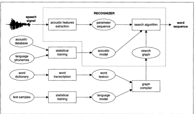
Modern systems are based on a search algorithm which looks for the most probable word sequence that matches with a suitable parametric representation of the input speech signal (Figure 1.2). The search is performed on a probabilistic graph which represents all possible word sequences and their corresponding phonetic transcriptions. Probabilistic matching with the input signal is made at the level of phonemes by means of a statistical acoustic model, which is capable of modeling both
duration and frequency variations of each phoneme. The acoustic model is trained on a large sample of speech recordings. The search graph is initially built from a dictionary and a statistical language model, and is then trained on a text body representing the application language.
Figure 1.2: Architecture of a speech recognizer
1.5.2 Speech synthesis
Speech synthesis programs convert written input to spoken output by automatically synthetic speech. Speech synthesis is often referred to as Text-to-Speech or TTS.
generating
As there are several algorithms, the choice will depend on the task they are going to be used for. The easiest way is to simply record a person's voice uttering the desired phrases. However, this method is only effective if a restricted volume of phrases and sentences is used, for instance, messages in a train station, or schedule information via phone. Needless to say, quality depends on the way the recording was done. Nevertheless, this method is inadequate for free-form text.
There are also algorithms, more sophisticated but inferior in quality, which split the speech into smaller pieces. The smaller the units, the fewer required, but the quality also decreases. A frequently used factor is the phoneme: the smallest linguistic unit. Depending on the language, there are about
Chapter 1: Introduction 21
word sequence
35-50 phonemes in western European languages, that is, there will be 35-50 single recordings. Since fluent speech requires smooth transitions between the elements, the problem lies in combining them. If there are few recordings the intelligibility will be low, but the memory required will be small. A solution to this problem is to use diphones, that is, instead of splitting at the transitions, the cut is made in the middle of the phonemes, thus leaving the transitions themselves intact. This produces about 400 elements (20*20) and the quality increases. The longer the units, the more elements there will be, but quality increases along with the memory required. Other units which are widely used are: half-syllables, syllables, words or combinations of them; for example, word stems and inflectional endings. This method of lining is known as concatenative synthesis.
An alternative to the concatenating of digitized speech units is the parametric or formant synthesis method. In this case, speech is generated by modifying parameters that control a model of the vocal tract, and by doing so, over time, speech-like sounds are created. The vocal tract (the throat from the vocal cords to the lips) has certain resonant frequencies which change as the configuration of the vocal tract changes. The resonant peaks in the vocal tract transfer function (frequency response) are called "formants", and it is by the formant positions that the ear is able to differentiate one speech sound from another. Parametric synthesizers mimic the speech production mechanism using digital oscillators, noise sources, and filters (formant resonators); similar to electronic music synthesizers.
1.5.3 Speech technology used in comMotion
comMotion has a Graphical User Interface (GUI) as well as a speech interface. An important
consideration when defining the user interaction is the type of speech technology which will be integrated: discrete word recognition versus continuous speech; dependence versus speaker-independence; user activated speech recognition (by means of a push-to-talk button) or continuous speech recognition. Moreover, issues of performance, operating system compatibility and ease of integration must also be contemplated.
comMotion uses a combination of speech technologies. Speech recognition is used to accept speech
commands as an input medium. Speech synthesis is employed to convert textual input, such as shopping lists, to spoken output. In order to avoid the need for extensive training and provide the user with natural spoken interaction, a continuous speech, speaker-independent recognizer was chosen.
Speech commands in comMotion are used to :
" navigate between different to-do lists or within the items of a specific list, regardless of whether these items are text or recorded audio;
* record an audio item for a specific to-do list which can later be heard as recorded audio (the system does not have dictation capabilities, therefore, this item will not be seen as text in the GUI, but rather it will appear as a button to play the audio file);
* navigate between the reminders (electronic Post-it notes) of different locations; * browse the reminders of a specific location.
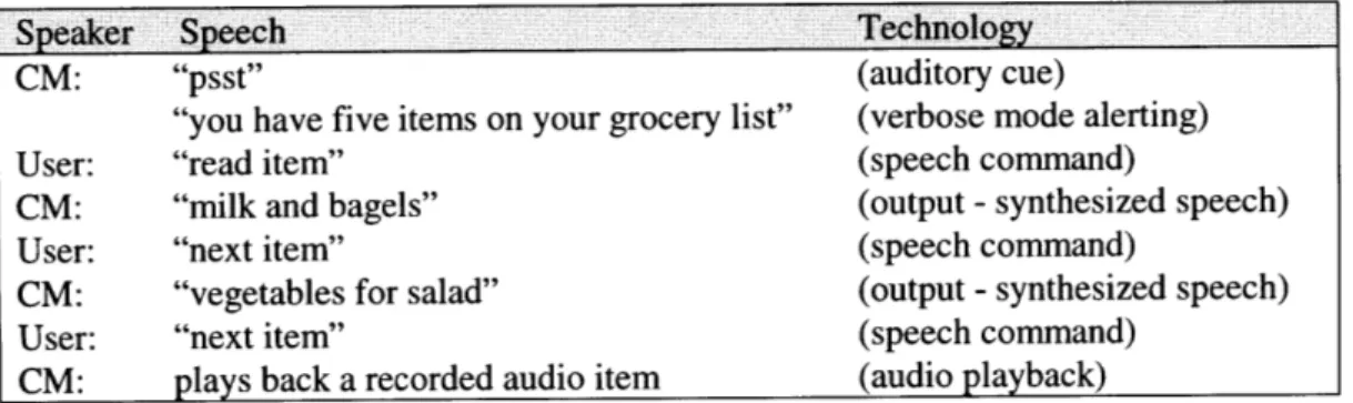
Speech is also used in auditory cues, as an alerting mechanism, and in audio playback. For example, as the user approaches his grocery store, the following dialogue (Table 1) may take place.
Speaker Speech Technology
CM: "psst" (auditory cue)
"you have five items on your grocery list" (verbose mode alerting)
User: "read item" (speech command)
CM: "milk and bagels" (output - synthesized speech)
User: "next item" (speech command)
CM: "vegetables for salad" (output - synthesized speech)
User: "next item" (speech command)
CM: plays back a recorded audio item (audio playback)
Table 1: Dialogue between comMotion (CM) and the user showing the different
speech technologies employed
As the user enters the vicinity of his grocery store, the system alerts him with an auditory cue, which serves as a subtle reminder. This cue has been pre-chosen by the user and is associated with his to-do lists. If operating in verbose mode, the system will also explain why the user is getting the alert; in this case, because he has pending items on the relevant to-do list. The user may then choose to act upon the reminder and interact with the system by means of speech commands. In this example, the user navigates through the list with simple two-word commands. If the item on the to-do list was entered as text, the user will hear it as synthesized speech. However, if the item was recorded audio, the system will play back the recorded speech.
By combining the different speech technologies, it is possible to operate the main features of
comMotion in a hands and/or eyes busy situation, that is, using speech as both input and output.
1.6 Document overview
Chapter 1 - explains the motivation behind comMotion, gives a basic overview of what the system does and defines terms and technologies used.
Chapter 2 - presents research done and applications designed in fields related to this thesis, that is,
mainly in the domain of mobile messaging and context-awareness, and points out the similarities and differences between comMotion and some of the other systems.
Chapter 3 - discusses design issues related to this work; the problematic aspects involved in the
creation of comMotion, such as the precision of the position information, or those which could evolve with the system itself, such as privacy.
Chapter 4 - lays out the architecture and the back end of the program, for example, the location
learning algorithm.
Chapter 5 - gives a detailed description of both the graphical and speech interface of each module.
Chapter 6 - presents the conclusions, as well as some preliminary user evaluations, and discusses future work.
Appendix A - includes a colour copy of some of the figures which appear in the text body. Colour is an important feature in the maps and in the visual component of the reminders (for example, the yellow immediately associates them with the very common 3M Post-itsTM).
2. Related work
comMotion builds on other research, applications, and ideas which have been developed over the last
few years, mainly in the fields of mobile messaging and context-awareness -both indoors and outdoors. Although similarities with these systems can be found, there are also a number of differences.
2.1 Context-aware systems - indoors
For interior location sensing, some type of active badge or beacon is usually used. Many of these badges use infra-red (IR) and, therefore, require line of sight between the transmitter and receiver. A number of systems based on this technology have been implemented, several of which also offer context-aware messaging for the office environment. Typically, the beacons are placed in passageways or transit areas between adjacent rooms, hence, the granularity of the information is at room-level.
2.1.1 The Active Badge Location System
The Olivetti Active Badge [5] is a beacon which transmits a unique code for approximately one tenth of a second every 15 seconds. These periodic signals are received by a network of sensors placed around the host building; a master station, also connected to the network, polls the sensors for badge "sightings". One of the applications implemented using this infrastructure was an aid for a telephone receptionist: the system provided a list of names and dynamically updated the field indicating the telephone extension number they were closest to, as well as a description of that location.
2.1.2 Forget-Me-Not
The Forget-Me-Not [6] was a wearable device which would record interactions with people and devices, and store this information in a database for later query. It interacted via wireless transmitters in the rooms and with equipment in the area to remember information such as who was there, who was being talked to on the telephone, and what objects were in the room. In this way, it allowed queries like: "Who came by my office while I was on the phone to Mark?". Its main function was to handle queries on information regarding daily activities (places visited, people met, documents
25
submitted, etc.) by using time as a retrieval key. Both the program and the data resided in a ParcTab device [7] developed by Xerox PARC.
Figure 2.1: The ParcTab personal digital assistant (PDA)
2.1.3 Locust Swarm
The Locust Swarm [8] is an environmentally-powered, networkless location and messaging system which supplies information to the wearable computer user, who can then control how much of this information is to be shared either with others or the installed infrastructure. The Locust [9] transmits its pre-specified location information, and the user's system can listen to this broadcast without being detected and decide whether or not to announce his presence. The Locust also monitors if a user is trying to upload an annotation to it: when a message has been added, the Locust will intermittently broadcast its location and the message number. When another user "hears" the message number, he can either ignore it or retrieve the message content from the database.
2.1.4 C-Map
C-Map (Context-aware Mobile Assistant Project) [10] is a tour guidance system which, based on location and individual interests, provides information to visitors at exhibitions. It uses Olivetti's Active Badge System [5] for location information. C-Map provides the user with both a geographical plan of the exhibit area and a semantic map indicating the exhibits recommended for his particular interests. To chart the latter, semantic relationships are established between the user's choice of listed keywords, and the actual displays.
2.1.5 Activity Server and Watcher
The Activity Server [11] is a system which periodically reports users' locations and activities, based on information it receives from: a finger server (which provides information on user activity on the local network), a phone server (providing information on use of phones), and a location server (which provides physical location of users wearing Olivetti Active Badges [5]). This system gives location
and activity information, such as, "Joe is alone in his office, active on computer-A". Watcher [38] is a
graphical interface to the Activity Server system.
2.1.6 RadioSpace
Using IR-based position tracking, RadioSpace [12] was designed to provide location awareness of
nomadic wearable computer users and their presence in physical space and time. The system enables
users to send messages to others or to different rooms. Moreover, dynamic Wed-based maps allow
them to view the location of other users and passively listen to cues indicating their activity. A
position-server maintains a history of user interaction and movement.
Figure 2.2: The RadioSpace Web-based dynamic map showing users' physical location
2.1.7 The Remembrance Agent
The Remembrance Agent [13] is a program which continuously monitors the wearable computer user
and displays one-line summaries of note-files, old e-mail, papers, and other text information which
might be relevant to the user's current context. These summaries are listed in a few lines at the bottom
of a heads-up display, so the wearer can read the information with a quick glance, however, to retrieve
the whole text described in a summary line, he must use a chording keyboard.
2.1.8 DyPERS
DyPERS (Dynamic Personal Enhanced Reality System) [14] is an audio-visual memory assistant which, using perceptual cues, prompts the user at relevant times. By means of a head-mounted camera and a microphone, it sees and hears what the user perceives, and thus collects an audio-visual memory. The resulting multimedia database can be indexed and played back in real-time. The user indicates to the system which visual objects are important memory cues, and in this way it will learn to recognize them in future encounters and associate them with the recorded memories. DyPERS was implemented in an application for a museum-gallery scenario: the user was given a tour with explanations of the paintings he was seeing. If and when the user sees the same paintings again, the
audio and video clips with the explanations he once heard, will be immediately triggered.
Figure 2.3: The DyPERS system
2.2
Context-aware systems
-outdoors
There are other systems which use GPS or bar-codes to track users and deliver information, for example, in guided tours of cities or a university campus. Most of these systems are not user-dependent, that is, the information is triggered according to physical location regardless of the user's identity.
2.2.1 CyberGuide and Savoir
The CyberGuide project [15] includes a series of prototypes of hand-held intelligent tour guides which provide information to tourists based on knowledge of their position and orientation. Prototypes for both indoor and outdoor tours were developed. The idea behind the project is that the size of a PDA is similar to that of the guidebook a tourist might take on vacation. Although the book might provide important practical information, such as locations of interesting sights, hotels and restaurants, it does not know where the tourist is located when he needs the facts. The application tries to predict what the user is attending to and supply relevant information.
The Savoir (Somewhat Assisted Voice-Only Interaction Research) project [16] explored issues related to context-awareness and voice-only computer interactions. A prototype, which enabled users to receive information from the Internet by means of a standard wired or cellular telephone, was developed. A version of CyberGuide, with an interactive tour guide facility, using the Savoir infrastructure and a GPS receiver, was implemented.
2.2.2 MetroNaut
MetroNaut [17] is an application developed for schedule negotiation and guidance instructions for a visitor to a university campus. It uses a bar-code reader for information input and position location, a two-way pager for communications, and an ARM processor for computation. The visitor's position is determined by reading bar-codes at information signs around campus. Modifications to the schedule are negotiated with the campus computing infrastructure by means of the two-way pager.
2.2.3 Stick-e Notes
Stick-e Notes [18] is an electronic version of the Post-it note. This application enables users to wander around outdoors attaching Stick-e Notes to locations and later have the notes trigger when passing through the area again. The system is user-dependent and GPS is used for positioning information.
2.2.4 FolksFinder
FolksFinder [19] consisted of a centralized Web-site which served as a clearinghouse for information produced by wearable computers equipped with GPS and cellular modems. Participants with wearable computers continually broadcast their positions to the centralized server from which they, and other non-wearable users, could access location information or be notified if a user was approaching a certain place.
2.2.5 City Guide
The City Guide application is part of the OnTheMove project [20]. It enables a user to know his geographical position by means of a digital map; as he moves, the map is scrolled to reflect his change in position. The user is able to view maps other than the one he is located on, scroll them, zoom them and search for restaurants and hotels. Position information is obtained by GPS; requested services are
received via WaveLAN or GSM. Larger and more detailed maps can be received if the connection is made through WaveLAN.
2.2.6 Augment-able Reality
The Augment-able Reality system [21] allows users to dynamically attach digital information, such as voice notes or photographs, to the physical environment, through wearable or desktop computers. Attached data is stored with contextual tags such as location IDs and object IDs -obtained by wearable sensors. Wearable users can then access the data when they come to the same context, regardless of whether the data was posted by another user.
2.3 Mobile messaging systems
Pagers and cellular phones are mobile communication devices, which are usually unaware of the user's context or physical location. Clues [22], a dynamic filtering system which has been in use over the last couple of years by some members of the MIT Media Lab and has been built into several messaging systems, infers geographic location from entries in the user's calendar, however, it does not know the user's actual location. Outdoor location information can be obtained from devices such as cellular phones through triangulation between base stations, in which case the location granularity is usually a cell. However, it is important to take into account that, in general, only service providers can know the location of a cellular phone and that this information is not usually available to the user. Still, cellular phones with built-in GPS units are starting to appear and, judging by the new-fashioned PDAs and cellular phones, connectivity, mobile messaging and access to personal organizer data, are becoming expected features.
2.3.1 Phoneshell
Phoneshell [23] permits mobile access to desktop applications. Using a touch-tone telephone, one can access e-mail, voice mail, calendar entries, Rolodex cards and hourly news broadcasts. Data entry, such as answering e-mail and adding new calendar items, is possible using DTMF tones or recording audio. Phoneshell is two-way, provided the user is motivated enough to type using the telephone keypad.
2.3.2 Chatter
Chatter [35] is a system which was built to provide the main functionality available in Phoneshell [23], however, with an improved voice interface. It used continuous, speaker-independent speech recognition for input and in this way enabled many more commands than is possible with DTMF tones. A discourse manager tracked the user's place in the dialogue and maintained context among separate tasks. For example, after reading a message from someone, the user could look up his number in the Rolodex and call. In addition, the system observed the user's history of actions and used this knowledge to predict the user's next action. For instance, if e-mail from a certain sender was always saved, the system would suggest: "Save it?".
2.3.3 Portico
Portico [36] is a virtual assistant which manages voice mail, e-mail, calendar and address book programs, and satellite news feeds. Interaction with the system is by means of natural language (as opposed to terse speech commands) through a phone, or via a Web-browser. The system can answer the phone, route calls or messages, make appointments, and prioritise and read e-mail messages. Certain personal information managers, such as the PalmPilot, can synchronise with Portico over the
Web.
2.3.4 Webley
Webley [37] is a personal communications assistant that places, screens, and takes calls in addition to forwarding e-mail, voice mail, faxes or pages to one or more locations. Moreover, other communication can also be controlled over the phone (with speech recognition or with touch tone keys), or over the Web. For example, it is possible to hear an e-mail message and dictate a reply; hear a voice message, record an answer and have the system return the call and play your recorded answer; or place a conference call.
2.3.5 Nomadic Radio
Nomadic Radio [24] is an audio-only wearable interface which permits one-way access to remote information services, such as e-mail, voice mail, hourly news broadcasts and personal calendar events. The messages are automatically downloaded to a wearable device throughout the day and users can
browse them using speech recognition and a tactile input. Nomadic Radio uses the Clues [22] dynamic filtering system and the user's level of attention (inferred from his degree of interaction with the system) to offer timely messages. To provide an unobtrusive interface for nomadic users, the audio/text information is presented using a combination of ambient and auditory cues, synthetic speech and spatialized audio. Moreover, it's alerting system is adaptive.
Figure 2.4: Nortel's Soundbeam Neckset wireless
telephone, adapted for Nomadic Radio
2.3.6 Knothole
Knothole [25] is a system which uses two-way pagers as a mobile interface to a desktop computer, hence, it combines PDA functionality, communication, and Web access into a single device. Instead of putting the intelligence into the portable appliance, it relies on a wireless network to connect to services which enable access to multiple desktop databases, such as a calendar or Rolodex, and external sources, such as news, weather, stock-quotes, and traffic.
Figure 2.5: The Motorola PageWriter 2000
2.3.7 Active Messenger
We have abundant channels through which a message can reach us, such as, e-mail, voice-mail, wired and cellular phones, different pagers, and fax machines. Active Messenger [26] infers the user's location based on which device he last used, and modifies its filtering and forwarding rules accordingly. For example, use of your business phone would indicate you were in your office, whereas use of an iridium pager would probably indicate that you were out in the middle of nowhere.
2.3.8 AT&T PocketNet Service
PocketNet [27] is a wireless information-access service provided by AT&T which enables users to link to their desktop and access their e-mail, calendar and Internet sites. The e-mail and personal organizer data is synchronized with the desktop. Currently, two manufacturers are offering wireless phones that are compatible with AT&T PocketNet service: the Samsung Duette and the Mitsubishi 100. Furthermore, software companies such as Umail [28] are providing services, based on PocketNet, which enable the delivery of Internet-based services to wireless telephones or a PalmPilot.
Figure 2.6: A PalmPilot with a Minstrel 19.2 Kbps wireless IP modem
2.3.9 Ericsson, Motorola and Nokia
American Personal Communications (APC), a subsidiary of Sprint, is using GSM as the technology for a broadband Personal Communications Service (PCS). This will ultimately have more than 400 base stations for the palm-sized handsets being made by Ericsson, Motorola, and Nokia. The handsets include a phone, a text pager, and an answering machine.
Nokia's 9000il Communicator [29] is a fully integrating GSM 1900 digital phone with a personal organizer, fax capabilities, data and messaging services, as well as Internet access. However, the user must sync-up with the standard calendar programs and other applications on his PC.
Figure 2.7: The Nokia 9000il Communicator with
personal organizer, fax capabilities,
data and messaging services
2.3.10 3Com's Palm VII
A widely anticipated product is 3Com's Palm VII. This device, currently in field tests, will combine the functions of a standard Palm hand-held organizer with a wireless connection for Web and intranet access, as well as two-way messaging.
2.3.11 GPS and mobile phones
GPS receivers have been combined with mobile phones for a number of functions. An interesting application of location information and messaging is one to protect vehicles: the GPSS system [30]. The GPS and mobile phone electronics are hidden in the vehicle to be protected. The system requires a PC running GPSS, and a modem connected to a regular telephone; the computer could be located anywhere in the world. If the car is stolen, and you want to know where it is, you simply use the telephone to dial up the number, and the GPS in the car then sends back GPS data every second, without those in the car knowing. The data is displayed on maps (GPSS software) running on the PC.
2.3.12 Garmin Navtalk GPS
/
Cell-phone
The Garmin Navtalk [31] is a combination of an analog cell-phone and a GPS receiver, with touch-tone location reporting and numeric paging. On the display, you can see exactly where you are calling from and this information can be sent to another unit. It is a full-featured GPS receiver and includes an internal database with cities and roads in North and South America.
2.4 How comMotion differs
comMotion has integrated and learned from many of the aforementioned systems. As a result, it
correlates with some of these in the sense that it uses position data to provide context-aware information. Nevertheless, comMotion also differs in several regards, namely time, place and information. However, what sets it apart is its independent-learning property.
2.4.1 Time
Systems such as the Forget-Me-Not [6], the Remembrance Agent [13] and DyPERS [14] serve as a memory prosthesis and augment memory for past events. In comMotion, the to-do lists and reminders are amongst the main features, that is, the system relates to events in the future. Since comMotion does not keep a record of past events, it could be a good complement to a system such as the Remembrance Agent. In practice, a user could choose to never delete old items from a to-do list or old reminders, and in this way have a record of the past. However, this would be very inconvenient since the to-do lists would become endless and would contain mostly checked items. Furthermore, outdated reminders would not be triggered since the context (which includes the date) would never match. So although a record of the past would be possible, it would defeat the purpose of the system.
2.4.2 Place
The Locust Swarm [8] enables leaving messages at specific indoor locations and retrieving them, yet the user must be in the particular site to upload a message to the Locust and likewise in order to retrieve it. Stick-e Notes [18] permits the user to attach electronic Post-it notes in different locations but, once again, the user must be in the locale in order to retrieve the note. Unlike these, comMotion allows messages to be posted regardless of the user's location and in this way is more related to RadioSpace [12], which enables messages to be sent from any Web browser. A comMotion user can also choose to view all of his to-do lists and reminders, regardless of his current physical location, and likewise browse any reminders, past or future, that he has received from others.
Mobile messaging systems using the Clues [22] dynamic filtering, infer geographic location based on users' calendar entries. The Active Messenger [26] tries to infer location from the person's usage of the different devices and uses this knowledge to deliver timely messages to the most appropriate channel, or device. Since comMotion knows the users' exact, as opposed to inferred whereabouts, it
could be a good complement to the Active Messenger. It could not only provide the Active Messenger with the virtual location ("home", "work", "grocery store") of the user, but also serve as an obvious communication channel for timely message delivery.
2.4.3 Information
Certain ideas in the CyberGuide [15] and City Guide [20] projects are related to those implemented in
comMotion, however, these systems access predefined databases of maps and site information, as
opposed to user-definable information. comMotion users can also access maps and locale information; in addition they have personal location specific to-do lists and reminders, that is, user-defined information, as well as the possibility to subscribe, per location, to other Web available content, such as weather, headline news, and movies.
2.4.4 Behaviour learning
What is unique in comMotion is its behaviour-learning module. Behaviour learning in DyPERS, for example, relies on user input, that is, the user must classify the data and specify whether the system should remember this information. Moreover, none of the systems that I am aware of observe the user's mobility data and identify frequented locations. Although the comMotion user can explicitly teach the system, for instance, when visiting a place for the first time, this type of teaching is not necessary. Once comMotion has located a site, after the third visit, it will learn it on its own and simply ask the user for feedback in the form of a virtual location name ("home", "work", "grocery store", etc.) or a command to ignore, for example, in the case of a bus-stop. In that sense, comMotion does not rely on the user for its learning process.
To sum up, comMotion, through its multi-modal interface, uses context-awareness to provide the mobile user not only with timely information, but also with the possibility of choosing the most appropriate type of interaction, that is, text and/or speech. No boot-strapping is required, rather, the behaviour-learning agent monitors the user and progressively learns the salient locations in his life, hence relieving him from the tedious task of classifying data or filling out preliminary forms. Once these frequented locations have been established, the system uses this knowledge to deliver to-do list items, relevant reminders and other information, when and where it is needed.
3. Design issues
The main objective of this work was to build a personal system which constantly knows the user's location and exploits this knowledge to deliver timely information. For the device to be most effective it should be highly portable and, hence, should be with or on the user at all times. Furthermore, it must enable multi-modal interaction to accommodate the user's different possible contexts.
comMotion, with the appropriate hardware, and with some modifications in the software could
accommodate different architectures. A number of scenarios can be envisioned, each adapted for different life-styles, or different modes of mobility:
" a wearable on-the-go architecture for the highly active, such as, cyclists; * a car architecture for the more sedentary;
* a briefcase architecture for the mobile individual, for example, knowledge workers; or * a stripped down kids architecture.
These are all variations on the same comMotion system, tailored to different needs. What changes is the hardware (cfr. section 3.6) and the features included in the system which range from full-fledged to stripped down variations.
Although the different architectures represent different paradigms, they share many design issues.
3.1 Why speech?
Computers are becoming smaller and faster; consequently they are becoming more mobile. However, their traditional interface (namely the display and keyboard) is simply being proportionally scaled down. As computers become more portable, our expectations of them change. For example, if we have a computer with us in the car or while walking down the street, why not be able to use it in these situations? Small displays and keyboards do not necessarily meet this new demand where our hands and eyes might be busy and we may be attending to another task, such as driving. In such circumstances, a speech interface is beneficial and auditory alerting essential (cfr. section 3.3.1).
Speech , on the one hand, provides portability since a microphone is much smaller, lighter and easier to carry than a keyboard, and it can be used even when one's hands and/or eyes are busy. Likewise, it