HAL Id: hal-01141698
https://hal.archives-ouvertes.fr/hal-01141698
Submitted on 13 Apr 2015
HAL is a multi-disciplinary open access
archive for the deposit and dissemination of
sci-entific research documents, whether they are
pub-lished or not. The documents may come from
teaching and research institutions in France or
abroad, or from public or private research centers.
L’archive ouverte pluridisciplinaire HAL, est
destinée au dépôt et à la diffusion de documents
scientifiques de niveau recherche, publiés ou non,
émanant des établissements d’enseignement et de
recherche français ou étrangers, des laboratoires
publics ou privés.
Building a field- and model-based climatology of surface
energy and water cycles for dominant land cover types
in the cultivated Sahel. Annual budgets and seasonality
C. Velluet, J. Demarty, B. Cappelaere, Isabelle Braud, H.B.A. Issoufou, N.
Boulain, D. Ramier, I. Mainassara, G. Charvet, M. Boucher, et al.
To cite this version:
C. Velluet, J. Demarty, B. Cappelaere, Isabelle Braud, H.B.A. Issoufou, et al.. Building a field- and
model-based climatology of surface energy and water cycles for dominant land cover types in the
cultivated Sahel. Annual budgets and seasonality. Hydrology and Earth System Sciences, European
Geosciences Union, 2014, 18 (12), pp.5001-5024. �10.5194/hess-18-5001-2014�. �hal-01141698�
www.hydrol-earth-syst-sci.net/18/5001/2014/ doi:10.5194/hess-18-5001-2014
© Author(s) 2014. CC Attribution 3.0 License.
Building a field- and model-based climatology of local water
and energy cycles in the cultivated Sahel
– annual budgets and seasonality
C. Velluet1,2, J. Demarty2, B. Cappelaere2, I. Braud3, H. B.-A. Issoufou4, N. Boulain2, D. Ramier2,5, I. Mainassara6,7, G. Charvet2, M. Boucher2,8, J.-P. Chazarin2, M. Oï2, H. Yahou4,7, B. Maidaji4,6, F. Arpin-Pont9, N. Benarrosh2,
A. Mahamane4, Y. Nazoumou7, G. Favreau2, and J. Seghieri2
1Université Montpellier 2, UMR HSM (CNRS/IRD/UM1/UM2), Montpellier, France 2IRD, UMR HSM (CNRS/IRD/UM1/UM2), Montpellier, France
3IRSTEA, Unit HHLY, Lyon, France
4Université de Maradi, Biology Department, Maradi, Niger 5Cerema, DTer IDF, Trappes-en-Yvelines, France
6IRD, UMR HSM (CNRS/IRD/UM1/UM2), Niamey, Niger
7Université Abdou Moumouni, Geology Department, Niamey, Niger 8IRD, LTHE, Grenoble, France
9CNRS, UMR HSM (CNRS/IRD/UM1/UM2), Montpellier, France
Correspondence to: B. Cappelaere (bernard.cappelaere@ird.fr)
Received: 9 March 2014 – Published in Hydrol. Earth Syst. Sci. Discuss.: 13 May 2014 Revised: 10 October 2014 – Accepted: 13 October 2014 – Published: 10 December 2014
Abstract. In the sub-Saharan Sahel, energy and water
cy-cling at the land surface is pivotal for the regional climate, water resources and land productivity, yet it is still very poorly documented. As a step towards a comprehensive cli-matological description of surface fluxes in this area, this study provides estimates of long-term average annual bud-gets and seasonal cycles for two main land use types of the cultivated Sahelian belt: rainfed millet crop and fallow bush. These estimates build on the combination of a 7-year field data set from two typical plots in southwestern Niger with detailed physically based soil–plant–atmosphere modeling, yielding a continuous, comprehensive set of water and en-ergy flux and storage variables over this multiyear period. In the present case in particular, blending field data with mech-anistic modeling makes the best use of available data and knowledge for the construction of the multivariate time se-ries. Rather than using the model only to gap-fill observa-tions into a composite series, model–data integration is gen-eralized homogeneously over time by generating the whole series with the entire data-constrained model simulation. Cli-matological averages of all water and energy variables, with
associated sampling uncertainty, are derived at annual to sub-seasonal scales from the time series produced. Similarities and differences in the two ecosystem behaviors are high-lighted. Mean annual evapotranspiration is found to repre-sent ∼ 82–85 % of rainfall for both systems, but with differ-ent soil evaporation/plant transpiration partitioning and dif-ferent seasonal distribution. The remainder consists entirely of runoff for the fallow, whereas drainage and runoff stand in a 40–60 % proportion for the millet field. These results should provide a robust reference for the surface energy- and water-related studies needed in this region. Their significance and the benefits they gain from the innovative data–model integration approach are thoroughly discussed. The model developed in this context has the potential for reliable sim-ulations outside the reported conditions, including changing climate and land cover.
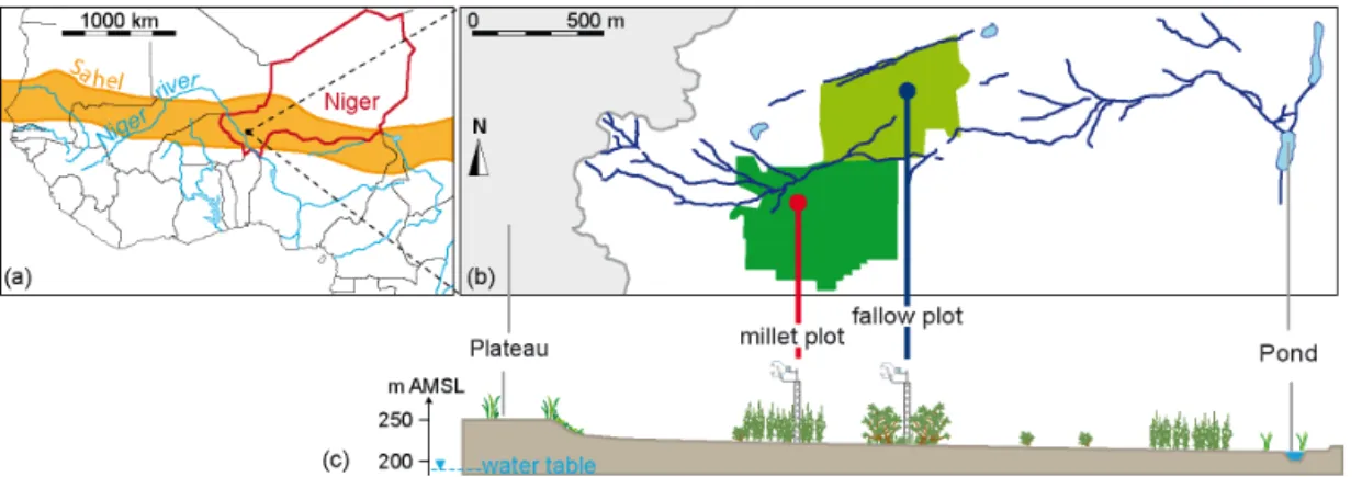
Figure 1. Situation of study plots: (a) location in Sahelian southwestern Niger, West Africa, (b) planar and (c) cross-sectional views of
Wankama hillslope with plot locations (modified after Ramier et al., 2009; vegetation and towers not sketched to scale in c).
1 Introduction
In Africa, counterintuitive water cycle dynamics (Favreau et al., 2009; Descroix et al., 2013) and prospects of increased water stress (Boko et al., 2007) or decreasing yields of rain-fed agriculture (Schlenker and Lobell, 2010) challenge our ability to provide reliable projections of these key resources, especially in the densely populated, semiarid Sahel (rainfall
∼300–700 mm yr−1; Fig. 1a). Surface–atmosphere interac-tions are critical processes for the water cycle in this region. Strong evaporation recycles much of the rainfall to the atmo-sphere locally (Boulain et al., 2009b), and the surface feed-back as vapor and radiative or turbulent energy plays a major role in atmosphere dynamics (Koster et al., 2004; Wolters et al., 2010; Taylor et al., 2011, 2012). Hence, meteorology, rainfall, and primary production all strongly depend on pro-cesses at the ground–atmosphere interface (GAI), as does recharge of the many ponds and of the underlying aquifer (Cappelaere et al., 2009; Favreau et al., 2009; Massuel et al., 2011).
Despite the importance of these surface processes, quan-titative knowledge of surface exchanges and ground– atmosphere interactions is still very limited in sub-Saharan Africa. Their distribution in space and time is all the more poorly documented. In the Sahelian domain of the West African monsoon, scarce field observations have generally covered only short periods of time – typically a few days to a few weeks – at a few sites (e.g., Lloyd et al., 1997; Ezza-har et al., 2009; Timouk et al., 2009). Few studies have cov-ered a complete seasonal cycle (Wallace et al., 1991; Miller et al., 2009; Ramier et al., 2009). To our knowledge, none have been based on a period of several years that is needed to capture the strong interannual variability of Sahelian rain-fall. Current adverse public security conditions throughout the Sahelian belt leave little hope that the complex type of instrumentation required (eddy covariance, scintillometry) could be significantly densified in the near future. In this con-text, remote sensing estimations are particularly promising
for this region. However, methods are still in development, and require context-specific field evaluation and calibration (e.g., Tanguy et al., 2012; Verhoef et al., 2012; Marshall et al., 2013). This is also true for model-derived estimates, as the ability of the current generation of land surface mod-els (LSMs) to correctly reproduce dominant land processes in Africa is still largely in question (Boone et al., 2009a). Evaluating and improving the capabilities of general-purpose LSMs for this large continental region requires substantial reliable documentation of surface energy and water cycles at different space- and timescales (Boone et al., 2009b).
When available, field estimates of surface fluxes are un-doubtedly an invaluable asset. Nearly all components (radia-tive, conduc(radia-tive, turbulent) of the surface energy cycle are now more or less readily accessible to field estimation, even though this involves rather complex techniques and inhomo-geneous representative scales. However, these data are as-sociated with significant uncertainty, particularly for turbu-lent fluxes of sensible and latent heat. This uncertainty arises from a variety of sources such as instrumental error, depar-ture of field conditions from underlying theory, or process-ing pitfalls (Foken et al., 2006; Aubinet et al., 2012). The general lack of energy balance closure that results from these estimation problems typically ranges between 10 and 35 % of the available energy (Foken, 2008). Its assignment to the various possible sources is still a matter of debate (Aubinet et al., 2012). When estimation becomes unreliable, the cor-responding data must be discarded. Added to the recurrent interruption of sensitive equipment in harsh field conditions (dust, temperature, wind), this generally leads to substantial gap rates in the derived time series. For the surface water cy-cle, a number of components can hardly be field-measured precisely and continuously on a routine basis, e.g., overland runoff, vertical drainage, and lateral subsurface flow, or parti-tioning of evapotranspiration into direct soil evaporation and canopy transpiration. For all these reasons – sparse data sets, unobserved components, and uncertain data with conserva-tion biases – it is not feasible to estimate complete and
re-liable water and energy balances at various timescales from field observations only, and some sort of modeling is thus necessary. Combining as many field observations as possi-ble with physics-driven models, which integrate availapossi-ble knowledge of the main local water and energy cycling pro-cesses, appears to be the most reliable way to make robust quantitative estimates of surface–atmosphere exchanges, par-ticularly in this region.
In this context, the purpose of this study is to propose – for the first time to our knowledge – a description that can be representative, in a climatological sense, of water and en-ergy cycles for two dominant land cover types in the cul-tivated Sahel, namely rainfed millet crop and fallow bush. First-order dynamics at annual to sub-seasonal scales are an-alyzed here, through estimation of long-term means. A reli-able climatology is useful as a powerful reference for a va-riety of purposes, including extracting the most significant features in system dynamics, deriving anomalies, analyzing processes and understanding system behavior, making robust comparisons between systems or across different bioclimatic settings (globally or regionally as expected from the AMMA-CATCH1network in West Africa; Lebel et al., 2009), or eval-uating and improving land surface models and remote sens-ing algorithms efficiently (e.g., bias detection and character-ization).
This climatological description is based on the production and analysis of a multivariate series covering an unprece-dented full 7-year-long period for two plots in Niger (Velluet, 2014). This continuous series was obtained by combining a unique field data set over that period (Boulain et al., 2009a; Cappelaere et al., 2009; Ramier et al., 2009) with the phys-ically based SiSPAT (Simple Soil–Plant–Atmosphere Trans-fers) model (Braud et al., 1995). The study area is located in the so-called central Sahel region, which is considered the most representative of the West African monsoon rain-fall regime (Lebel and Ali, 2009). Available data include lo-cal rainfall and meteorology, vegetation phenology, all sur-face energy cycle components, and soil moisture and tem-perature profiles. The SiSPAT model solves the 1-D vertical equations for coupled diffusive transfers of water and heat in a heterogeneous soil, coupled with surface and plant ex-changes with the atmosphere. It has been shown (Demarty et al., 2004; Shin et al., 2012) that even in the general heteroge-neous, layered case, this type of soil water model can be reli-ably inverted for hydrodynamic properties from soil moisture observations when the profile is predominantly draining (no underlying moisture source), which is the case in nearly all of this region. SiSPAT has already been tested successfully over a short period in this environment (Braud et al., 1997; Braud, 1998). Other GAI studies, either data-based (e.g., Miller et al., 2009; Ramier et al., 2009; Lohou et al., 2014) or
model-1African Monsoon Multidisciplinary Analyses – Coupling
Trop-ical Atmosphere and HydrologTrop-ical Cycle; http://www.amma-catch. org.
based (e.g., Daamen, 1997; Pellarin et al., 2009; Saux-Picart et al., 2009a, b), were carried out in the study area. However, as mentioned earlier for the whole subregion, they were all limited to sub-seasonal periods or at most to one particular year. The models used were generally less detailed than in this study, with a more exploratory perspective. Deriving a reference climatology as done here requires a long-enough, complete, and reliable series. This required continuous mul-tivariate series is provided by the strongly data-constrained 7-year model simulation, which is used in its entirety rather than only for gap-filling observations into a composite se-ries. As the paper shows, the series allows capturing statisti-cal population averages for the variables investigated, while minimizing the effect of possible decadal non-stationarities of the monsoon (Lebel and Ali, 2009) or of land manage-ment. As it carries the most robust features in the dynamics, analysis of mean system behavior enables a powerful com-parison of the two investigated systems. These results should contribute a substantial step to documenting the dynamics of surface fluxes in the Sahel.
After a brief description of sites, data, model, and overall methodology (Sect. 2), results are presented for the climatol-ogy of a synthetic average year from annual to sub-seasonal timescales (Sect. 3). The significance of these results – as duced in particular by the study methodology – as well as in-formation inferred on key processes are discussed in Sect. 4. As they play a key part in the methodology, implementation and evaluation steps for model–data integration (parameter estimation, model validation) are detailed separately in Ap-pendices A and B, for better overall readability.
2 Materials and methods
Equations of water and energy conservation are written as
P = R + D +Ev + Tr + dS/dt
SWin=SWout+LWnet+Rnwith : Rn=G + H +LE (1)
and : LWnet=LWout−LWin;LE = λ · ET; ET = Ev + Tr,
where P is precipitation, R runoff, D drainage below soil column, Ev direct soil evaporation, Tr plant transpiration, ET evapotranspiration, dS/dt water storage variation in soil col-umn, Rnnet radiation, SWinglobal radiation, SWoutreflected
solar radiation, LWnet net long-wave radiation, LWin and
LWoutdown- and upwelling long-wave radiation, G ground
heat flux, H sensible heat flux, LE latent heat flux, and λ la-tent heat of vaporization (units used hereafter are millimeter per unit time for P , R, D, Ev, Tr, ET and dS/dt, W m−2for SWin, SWout, LWin, LWout, LWnet, Rn, G, H and LE, and
kJ m−3for λ).
2.1 Study area
The study area is located ∼ 60 km east of Niamey, at 13.6◦N, 2.6◦E in the southwest of the Republic of Niger (Fig. 1). It
consists of two plots of around 15 ha each, located ∼ 0.5 km apart on the slope of the 2 km2Wankama catchment, in the AMMA-CATCH observatory (Cappelaere et al., 2009; Lebel et al., 2009). The plots consist of a millet field – millet is the single most important staple crop in the whole Sahel belt – and of a fallow field which is an integral part of the tra-ditional cropping system (views of plots in Cappelaere et al., 2009; Boulain et al., 2009a; Velluet, 2014). These are now by far the two main land use types in southwestern Niger (Leblanc et al., 2008; Descroix et al., 2009), as in much of the cultivated Sahel (van Vliet et al., 2013). The climate of the area is tropical semiarid, with average rain-fall of ∼ 500 mm yr−1 and mean temperature of ∼ 30◦C. It is typical of the West African monsoon regime, with a long dry season of ∼ 6 months (November–April) with practi-cally no rain, and a wet season with 30–50 convective storms concentrated mostly from June through September. Figure 2 shows this strong meteorological seasonality at Wankama, especially for rainfall, humidity, and wind, and to a lesser extent temperature. Soils are sandy, weakly structured, poor in nutrients, and prone to surface crusting, with an unsatu-rated depth of several tens of meters (Massuel et al., 2006). Pearl millet (Pennisetum glaucum) is grown using traditional techniques, relying on rainfall and animal manuring with no irrigation and very little or no chemical fertilization. Sparse shrubs of Guiera senegalensis are left to grow in the crop fields and cut yearly just before the growing season (April– May). Before sowing, weeds are removed by shallow till-ing with a hand hoe. After the first 5–10 mm of rainfall, traditional non-photosensitive varieties of millet are sown in pockets with a ∼ 1 m spacing. Depending on subsequent rain or drought, it may need to be re-sown several times be-fore plants can actually develop. Millet is harvested in late September or October, after the end of the rainy season. Shrubs are allowed to grow again from any remaining soil moisture in the late monsoon, until the end of the dry sea-son. The fallow vegetation typically consists of a shrub layer dominated by Guiera senegalensis (< 103individuals ha−1,
∼2 m high) and of a grass layer made of annual C3 and C4 species in variable composition, interspersed with bare soil patches (Boulain et al., 2009a). Traditional crop–fallow cy-cles used to alternate 10–20 years of fallow with 3–5 years of cropping, but with the acute need for food production this ratio is now almost reversed.
2.2 Field data and study period
At the start of the 2005 monsoon, the two plots were equipped with an identical data acquisition setup for con-tinuous recording of (i) meteorology: rainfall, air pressure, temperature and humidity, wind speed and direction, four-component radiation; (ii) high-frequency eddy covariance for sensible and latent heat flux estimation: 3-D wind, tem-perature, and vapor concentration (carbon flux also moni-tored but not used in this study); (iii) soil variables: shallow
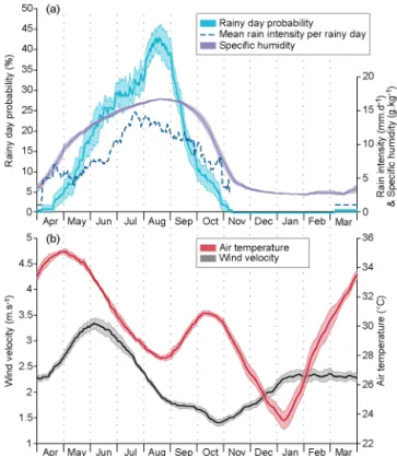
Figure 2. Mean seasonal courses of meteorological variables in
Wankama catchment: (a) probability and mean rain intensity of a rainy day and specific humidity; (b) air temperature and 3 m wind velocity. Values are 30-day running averages for 2005–2012, from instruments described in Table 1. Light-colored intervals represent a variation of ±1 standard estimation error.
ground heat flux, 2.5 m deep temperature and moisture pro-files. Details of this setup are given in Table 1. The millet plot was turned to cultivation just before instrumentation began in 2005, while the fallow field had not been cropped since the early 2000s. In both plots, land use remained unchanged throughout the 7-year study period (May 2005–April 2012). Soil texture and bulk density were analyzed from samples taken along several 2.5 m deep profiles at different dates over the period to calibrate soil moisture sensors for volu-metric water content. Consistent particle size distributions of
∼84–92 % sand and ∼ 5–13 % clay were found in all pro-files. Porosity was estimated from bulk density, in the range of 0.32–0.36 m3m−3.
For the practical and theoretical reasons mentioned earlier (e.g., equipment failure, temporarily unsuitable conditions), the data series include gaps of variable lengths (10–35 % missing data). Meteorological variables, needed for model forcing, were gap-filled by substituting the closest available data from similar instruments deployed over the Wankama catchment (Cappelaere et al., 2009). Eddy covariance data were processed into half-hourly turbulent fluxes, using EdiRe software (R. Clement, University of Edinburgh) and Car-boEurope recommendations (Mauder and Foken, 2004), as described in Ramier et al. (2009). Energy balance closure
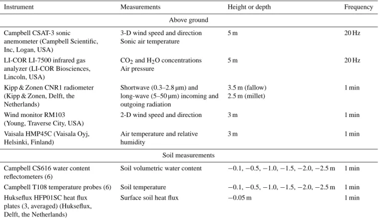
ob-Table 1. Description of permanent GAI-recording stations in the Wankama fallow and millet plots.
Instrument Measurements Height or depth Frequency
Above ground
Campbell CSAT-3 sonic 3-D wind speed and direction 5 m 20 Hz
anemometer (Campbell Scientific, Sonic air temperature Inc, Logan, USA)
LI-COR LI-7500 infrared gas CO2and H2O concentrations 5 m 20 Hz
analyzer (LI-COR Biosciences, Air pressure Lincoln, USA)
Kipp & Zonen CNR1 radiometer Shortwave (0.3–2.8 µm) and 3.5 m (fallow) 1 min (Kipp & Zonen, Delft, the long-wave (5–50 µm) incoming and 2.5 m (millet)
Netherlands) outgoing radiation
Wind monitor RM103 2-D wind speed and direction 3 m 1 min
(Young, Traverse City, USA)
Vaisala HMP45C (Vaisala Oyj, Air temperature and relative 3 m 1 min
Helsinki, Finland) humidity
Soil measurements
Campbell CS616 water content Soil volumetric water content −0.1, −0.5, −1.0, −1.5, −2.0, −2.5 m 1 min reflectometers (6)
Campbell T108 temperature probes (6) Soil temperature −0.1, −0.5, −1.0, −1.5, −2.0, −2.5 m 1 min
Hukseflux HFP01SC heat flux Surface soil heat flux −0.05 m 1 min
plates (3, averaged) (Hukseflux, Delft, the Netherlands)
tained with the different measured and estimated flux compo-nents is typical of what is commonly obtained with this type of instrumentation (Ramier et al., 2009). Extracts from these eddy covariance data have been extensively analyzed in vari-ous – local, regional, methodological – studies (e.g., Boulain et al., 2009a; Merbold et al., 2009; Ramier et al., 2009; Tan-guy et al., 2012; Verhoef et al., 2012; Marshall et al., 2013; Sjöstrom et al., 2011, 2013; Lohou et al., 2014).
A field survey of vegetation phenology was conducted at both plots every 1 or 2 weeks from June through De-cember of all 7 years (Boulain et al., 2009a). Of particular interest for this study are the seasonal courses of vegeta-tion height and leaf area index (LAI). Height was sampled from 15–30 individuals per plot and date. LAI was derived from hemispherical photographs, following the protocol pre-scribed by the VALERI project (http://www.avignon.inra.fr/ valeri). They were acquired at 13 locations in a 20 × 20 m square in each plot, using a Canon EOS 500 numerical cam-era with a Sigma-8mm-F4 fisheye lens, and were processed with the Can-Eye software (Weiss et al., 2004). To obtain continuous daily series over the study period (Fig. 3), LAI was interpolated between surveys and extrapolated outside surveying periods based on a regression on surface albedo, as recorded by the shortwave radiometers.
2.3 Model principles
The SiSPAT model (Braud et al., 1995; Braud, 2000; De-marty et al., 2002) was chosen for its ability to simulate the coupled heat and water exchanges through the soil–plant– atmosphere continuum on physical bases. Model overview diagrams are provided by Fig. 1 in Demarty et al. (2004) and Fig. 6.2 in Velluet (2014). As a SVAT (soil–vegetation– atmosphere transfer) column model, it is forced at a reference level with observed meteorology (rainfall, wind speed, air temperature and humidity, atmospheric pressure, incoming short- and long-wave radiation). Two energy budgets, one for the vegetation canopy and one for the soil surface, are solved concurrently and continuously for surface–atmosphere ex-changes over the diurnal cycle, with temperature and humid-ity at the soil surface, at the leaf surface, and at the canopy level of the atmosphere as state variables. Leaf area is pre-scribed as time-variable LAI, and also conditions a rainfall interception reservoir. Turbulent fluxes are expressed using a classical electrical analogy in this two-layer system, based on the computation of a bulk stomatal resistance and of three aerodynamic resistances. The bulk stomatal resistance, rep-resenting the plant physiological response to climatic and environmental conditions, is modeled in terms of incoming global radiation, vapor pressure deficit, and leaf water po-tential (Jarvis, 1976). The three aerodynamic resistances are determined using the Shuttleworth and Wallace (1985) wind
profile parameterization inside and above the canopy. Radia-tion transfers in the short- and long-wave bands account for the two-layer formalism with shielding and multiple reflec-tion effects (Taconet et al., 1986).
A major strength of the model is its mechanistic repre-sentation of soil thermal and hydraulic dynamics, accom-plished by solving the coupled differential equations of heat and mass transfer, including vapor phase. This allows in par-ticular to account for strong heterogeneity in the soil profile, e.g., the common presence of a surface crust in this envi-ronment or several soil horizons with contrasted thermal and hydraulic conduction and retention properties. Different pa-rameterizations of the hydraulic conductivity and retention curves are possible. Each horizon is discretized for a nu-merical solution of the dynamic and continuity equations, with variable node density in relation to magnitude of state variable gradients (e.g., higher near the surface or horizon boundaries). Water is extracted by plants based on a pre-scribed, constant or dynamic root density profile, assuming no plant storage (Federer, 1979; Milly, 1982). The above-and below-surface model components are coupled through soil surface temperature and humidity, leaf water potential, and conservation of energy and mass at the soil and plant surfaces. A lower boundary condition needs to be assigned for both the heat and mass transfer equations at the bottom of the simulated soil column. Various boundary condition types, including Dirichlet and Neumann types, are proposed (Braud, 2000). The model is forced with meteorological data at a sub-hourly timestep to capture the diurnal cycle, and the data are linearly interpolated at the computational timestep. The timestep is adjusted automatically according to soil wa-ter pressure and temperature gradients. This enables accurate representation of process dynamics (e.g., when sharp varia-tions occur during rain events) as well as satisfaction of nu-merical convergence and stability criteria.
The SiSPAT model has been previously applied to Sahe-lian sites near the study area (Braud et al., 1997; Braud, 1998), for relatively short simulation periods, but with en-couraging results as to the model’s ability to reproduce the Sahelian GAI behavior. It has also been used successfully in a variety of other complex, physics-oriented applications, such as isotopic tracing (e.g., Rothfuss et al., 2012) and remote-sensing simulations (e.g., Demarty et al., 2005).
2.4 Methodology
The SiSPAT model is forced for the fallow and millet plots with their 7-year (1 May 2005–30 April 2012) time series of half-hourly meteorological variables and daily LAI. A 4 m deep soil domain is modelled to minimize possible errors in surface energy and water fluxes arising from assumed bottom conditions. These conditions are gravitational water drainage and constant temperature taken as the observed multiyear av-erage at 2.5 m depth. To allow for vertical non-homogeneity, the soil column is divided into five horizons named H1 to H5,
with depth ranges of 0–0.01, 0.01–0.20, 0.20–0.70, 0.70– 1.20, and 1.20–4.00 m, respectively. The thin H1 horizon makes it possible to differentiate a surface crust – if any – from the soil proper. Separation of the latter into H2– H5 is derived from soil density profiles observed in the two fields. The five-layer soil column is discretized into a total of 194 computation nodes to ensure accurate state variable pro-files. These are initialized with soil water content and temper-ature profiles observed on 1 May 2005, linearly interpolated over the computation domain.
SiSPAT involves a rather large set of input parameters defining soil, vegetation, and surface properties (Table 2). Regarding soil properties, and based on previous experi-ences with the model for these Sahelian ecosystems (Braud et al., 1997; Braud, 1998), the water retention and conduc-tivity curves for each horizon are parameterized using the van Genuchten (1980) – with the Burdine (1953) condition – and the Brooks and Corey (1964) models, respectively. This leads to six hydrodynamic parameters (θsat, θr, Ksat, β, hg, n)
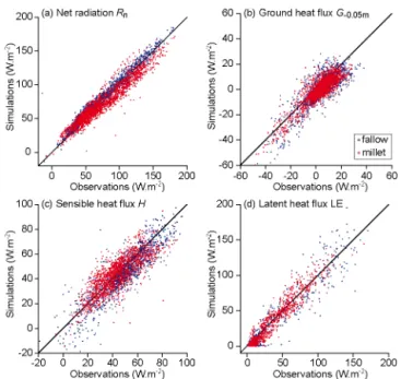
for each soil horizon (Table 2). For most model parameters, estimated values or plausible ranges are derived directly ei-ther from field observations or from the literature (Table 2). Note that pedotransfer functions are found to be of little help for prior conditioning of soil hydrodynamic properties, as ranges obtained are considerably larger than what is to be expected from the other information sources on these param-eters (Velluet, 2014). Four groups of paramparam-eters – denoted A to D in Table 2 – are differentiated, differing in the way they are assigned values in this model implementation, from di-rect assignment to model calibration on data from two of the 7 years. Definitions of these groups and corresponding pa-rameter assignment methods are detailed in Appendix A. Re-tained parameter values are shown in Table 2 and discussed in Appendix B together with model evaluation against the whole observation record, which reveals high model capabil-ity. Calibration evidences surface crusting at both sites, al-though much more significantly for the fallow.
The extensive validation of the simulated series (Ap-pendix B) permits derivation, from these entire multivari-ate series directly, of climatological averages for the wmultivari-ater and energy fluxes at both plots for annual to sub-seasonal (running monthly with a view to daily) timescales (Sect. 3). Despite the moderate sample size, sampling-induced uncer-tainty on estimated means is quite small. Combined with the high model skill, this small statistical uncertainty suggests that robust climatological features can be inferred from the analysis. The significance of these results, as governed by the data and model used and by the way these two sources of in-formation are blended in the study methodology, is discussed in Sect. 4.1.
T able 2. V egetation, surf ace, and soil parameters in SiSP A T model (Braud, 2000), with v alues either calibrated (parameter groups C and D; see Appendix A for group definitions) or non-calibrated (parameter groups A and B). The right column sho ws prior v alues or ranges obtained from the literature: aBraud (2000); bJacquemin and Noihlan (1990); cHanan and Prince (1997); dMonten y (1993); eJackson (1988); Demarty et al. (2004); fRoujean, J. L. (1994; personal communication in Braud et al., 1997); gFrançois (2002); hHillel (1998); iBraud et al. (1997); jŠim ˚unek et al. (1998); kV anderv aere et al. (1997); lMan yame et al. (2007); m Klaij and V achaud (1992); nRockström et al. (1998); oHoogmoed and Klaij (1990); pGaze et al. (1997). P arameter Unit Group F allo w field Millet field Literature v alues V egetation parameters F allo w Millet V apor deficit factor in P a − 1 B 2.50 × 10 − 4 2.50 × 10 − 4 2.50 × 10 − 4 a plant stress function Critical leaf w ater m B − 140 − 140 − 140 i – potential Maximum stomatal s m − 1 B 5000 5000 5000 b resistance Minimum stomatal s m − 1 C 70 100 80 c 125 c resistance Total plant resistance s m − 1 root C 1.50 × 10 13 6.50 × 10 12 6.50 × 10 12i – Root density profile (T ime in v ariant) (At peak de v elopment) adjusted from P1: maximum root mroot m − 3 soil C 22 900 25 000 Braud Rockström density @ depth @ m @ 0.03 to 0.1 @ 0.03 to 0.1 et al. (1997) et al. (1998) P2: intermediate root mroot m − 3 soil C 1603 5000 density @ depth @ m @ 0.85 @ 0.50 P3: maximum root m C 3.5 2.3 depth Radiati v e surf ace parameters Bare soil albedo α = f (θ ): – dry albedo (θ = 0.04) – A 0.345 0.340 – – wet albedo (θ = 0.18) – A 0.190 0.200 – Bare soil emissi vity – B 0.97 0.97 0.97 d V egetation emissi vity – B 0.98 0.98 0.98 e V egetation albedo – C 0.20 0.22 0.20 f – Interception parameter: F or a spherical canop y: – long-w av e – B 0.825 0.825 0.825 g – shortw av e – C 0.45 0.55 0.50 g
T able 2. Continued. P arameter Unit Group F allo w field Millet field Literature v alues Soil parameters Horizon H1 H2 H3 H4 H5 H1 H2 H3 H4 H5 Crust Soil depth (m) 0–0.01 0.01–0.2 0.2–0.7 0.7–1.2 1.2–4.0 0–0.01 0.01–0.2 0.2–0.7 0.7–1.2 1.2–4.0 Dry b ulk density g cm − 3 A 1.70 1.70 1.80 1.70 1.75 1.70 1.70 1.80 1.70 1.75 – Porosity 8 – A 0.358 0.358 0.321 0.358 0.340 0.358 0.358 0.321 0.358 0.340 – Sand % A 85 85 85 85 85 85 85 85 85 85 – Clay and silt % A 13 13 13 13 13 13 13 13 13 13 – Or g anic matter % A 2 2 2 2 2 2 2 2 2 2 – Dry v olumetric heat 10 6 J m − 3 K − 1 A 1.28 1.28 1.36 1.28 1.32 1.28 1.28 1.36 1.28 1.32 = 2 × 10 6 (1 − 8) a,h capacity Saturated w ater m 3 m − 3 A 0.30 0.30 0.30 0.30 0.30 0.30 0.30 0.30 0.30 0.30 [0.25; 0.35] i, j, k [0.25; 0.42] i, j, k, l, n content θ sat Residual w ater m 3 m − 3 A 0.01 0.012 0.028 0.027 0.037 0.01 0.023 0.046 0.047 0.056 [0; 0.03] i, j [0; 0.06] i, j, l, m, n content θ r Retention curv e m D − 0.85 − 0.60 − 0.40 − 0.30 − 0.20 − 0.50 − 0.30 − 0.30 − 0.20 − 0.20 [− 24; − 0.31] i, j [− 0.60; − 0.06] i, j, l, n shape parameter h g Retention curv e – D 2.75 3.00 3.10 3.00 3.30 2.75 3.00 3.00 3.00 3.00 [2.35; 3.53] i, j [2.55; 4.19] i, j, l, n shape parameter n Saturated h ydraulic m s− 1 D 1 × 10 − 7 7 × 10 − 5 5 × 10 − 5 7 × 10 − 5 7 × 10 − 5 2.5 × 10 − 7 5 × 10 − 5 5 × 10 − 5 5 × 10 − 5 5 × 10 − 5 [1.7 × 10 − 8 ; [4 × 10 − 6 ; conducti vity K sat 2 × 10 − 6 ]i, j, k 7 × 10 − 5 ]i–p Conducti vity curv e – D 6.0 5.0 5.0 4.5 5.0 6.0 5.0 5.5 5.5 6.0 [4.3; 6.1] i shape parameter β Soil thermal conducti vity – D 2.00 1.50 1.00 1.00 1.00 1.00 0.75 0.85 1.00 1.00 Def ault v alue: 1.00 scaling parameter
Figure 3. Seasonal course of daily LAI at (a) fallow and (b) millet plots for each growing season of 2005–2011 (in brackets: total rainfall, in
millimeters).
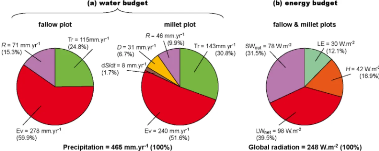
Figure 4. Estimated mean annual (a) water and (b) energy budgets for fallow and millet plots (average of two plots for energy budget, given
their similarity at that aggregation scale). Please see Eq. (1) for abbreviations and Fig. 5 for standard estimation errors.
3 Results: climatology of energy and water cycling at
the GAI
Over the 7-year period, rainfall shows interannual variabil-ity in amount and timing in line with that reported for the Wankama catchment over the longer 1992–2006 period (Ramier et al., 2009), suggesting that our study period is representative of the general conditions prevailing in this area. Specifically, annual rainfall (values in legend of Fig. 3) ranges from 350 to 580 mm yr−1, with a mean and a stan-dard deviation of 465 and 81 mm yr−1, respectively. Three years have similar, moderately below-average annual rainfall (420–430 mm yr−1), but differ in the number (38–50),
inten-sity, and time distribution of rain events.
Simulated variables are analyzed in their distribution at an-nual, semianan-nual, seasonal, and sub-seasonal scales over the study period, with the aim of estimating an average year for each site from this 7-year sample. Since climatological dif-ferences in forcing fluxes (rainfall, incoming short- and long-wave radiation) between the two sites are all very small, these specific variables are not duplicated in the following.
3.1 Annual and semiannual scale
The two pie charts in Fig. 4a display the distribution of the in-terannual mean water balance into its component parts for the fallow and the millet systems. It can be seen that (i) direct soil evaporation is the largest component for both systems, and for the fallow particularly (60 % of total rainfall against 52 % for the millet field); (ii) canopy transpiration is the second largest in both cases, albeit lower in the fallow (25 %) than in the millet field (31 %); (iii) these two evaporative compo-nents result in quite similar total evapotranspiration for the two systems that largely dominates the water balance (85 and 82 %, respectively); (iv) runoff ranks next in magnitude for both systems, but is substantially larger for the fallow (15 % against 10 % for the millet field), (v) drainage (< 7 %) and to a lesser extent interannual 0–4 m soil storage variation (< 2 %) is significant in the millet system only (none in the fallow). Canopy interception/evaporation is found to be non-significant in both systems.
Because, at this largest timescale, differences between the two systems are much less substantial for the energy
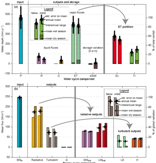
bal-Figure 5. Estimated (a) water and (b) energy budgets at annual and semiannual scales: interannual ranges (black thin bars), annual means
with standard estimation errors (black thick bars), and seasons means (light color for wet season, May–October; dark color for dry season, November–April), for the fallow (solid contours) and millet (dashed contours) plots. See Eq. (1) for abbreviations. Note that half-year water depths (color bars in a) are stacked to yield annual values, whereas annual energy fluxes are obtained as the means of half-year mean intensities (b).
ance, a similar decomposition – in this case of total global radiation – is presented only for the average of the two sys-tems (Fig. 4b). It shows that net long-wave radiation is the main component (40 % of global radiation), closely followed by reflected solar radiation (32 %). Sensible heat ranks next (17 %), followed by latent heat (12 %). Soil heat flux is negli-gible at this scale of integration. When compared to a global-averaged continental energy budget (Trenberth et al., 2009), all components are found larger at the study site, including latent heat. Regarding radiative losses, reflected shortwave is closer to net long-wave loss than it is globally. As for turbu-lent losses, sensible heat is greater than latent heat, contrary to globe averages.
Figure 5 displays in more detail the climatological water and energy balances for both systems, at the annual scale and for two 6-month periods corresponding to the monsoon (May–October) and dry (November–April) seasons.
Elemen-tal components are also grouped by type: liquid versus atmo-spheric vapor fluxes for water (Fig. 5a) and radiative versus turbulent for energy (Fig. 5b). Estimated annual means are shown with standard estimation errors and sample ranges. It can be seen that sampling uncertainty of estimated means is very small for all energy variables (max. standard error of 2.8 W m−2for latent heat flux in the fallow) relative to en-ergy input (248 W m−2). Relative to the 465 mm yr−1 rain-fall, standard estimation error is higher for water balance components: up to 14.3 and 21.2 mm yr−1 for evaporation
and total evapotranspiration from the fallow, respectively. Results suggest that annual-scale differences between ecosystems – even though small for the energy balance – are statistically significant for most elemental components. Exceptions are turbulent (latent or sensible) heat fluxes, and also aggregated liquid fluxes. Hence, when switching ecosys-tems, tradeoffs occur at the annual scale between runoff and
Figure 6. Estimated mean seasonal courses of water cycle
com-ponents, for fallow (solid lines) and millet (dashed lines) plots:
(a) fluxes and rate of storage change in 0–4 m soil column; (b)
ra-tios of above evaporation and runoff means to rainfall. Means are computed across years and over a 30-day running window. Light-colored intervals in (a) show a variation of ±1 standard estimation error around the estimated mean (not shown for storage change, for legibility).
drainage (∼ 30 mm yr−1, with more runoff for the fallow and vice versa), between direct soil evaporation and canopy tran-spiration (∼ 33 mm yr−1, with more transpiration from the millet field and vice versa), or to a lesser extent between short- and long-wave radiation losses (< 6 W m−2, with more long-wave for the millet field and vice versa). Stronger yet is the tradeoff (∼ 50 W m−2) between radiative and turbulent
fluxes when switching seasons (more radiation in dry season and vice versa), particularly between long-wave and latent heat losses. Shortwave radiation and sensible heat are much less impacted, with only 9.3 and 6.6 W m−2variation, respec-tively. When considering 6-month seasons separately, sensi-ble heat, reflected solar radiation, and wet-season transpira-tion are still not very significantly different between ecosys-tems. In contrast, dry-season transpiration is much larger for the millet system with ∼ 23 % of annual total, versus ∼ 4 % for the fallow.
3.2 Detailed seasonal cycle
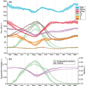
We are interested here in the general pattern of variation of daily variables over an average year, as can be derived from the 7-year sample. Figures 6a and 7a display the estimated interannual mean seasonal courses of water and energy bud-get components, respectively. A 30-day running averaging was applied to filter out high-frequency components and
ob-Figure 7. Estimated mean seasonal courses of energy cycle
compo-nents, for fallow (solid lines) and millet (dashed lines) plots: (a) in-coming shortwave and outgoing fluxes; (b) evaporative fraction and albedo. See Eq. (1) for abbreviations and Fig. 6 for further explana-tion of curves and colored intervals.
tain a more robust estimate of the low-frequency-dominated population’s mean seasonal cycle (the value of this filtering is further discussed in Sect. 4.1.3). The sample-induced stan-dard estimation error is shown as a confidence interval for each variable. It can be seen that the sample of years enables deriving interannual mean cycles with low statistical uncer-tainty, especially for most energy variables. Water cycle vari-ables show somewhat larger relative uncertainties, with the noticeable exception of millet transpiration for which statis-tical uncertainty is very small (< 0.14 mm d−1).
3.2.1 Water
The rainfall signal displays the slightly skewed bell shape, with a slow rise and sharp tail, that is typical of Sahelian rainfall seasonality (Fig. 6a). It is even strikingly close to the 1990–2007 mean seasonal cycle obtained for a 5◦×5◦ window centered on the study site (Lebel and Ali, 2009), in-cluding start/end timing, amplitude and timing of the peak (∼ 5.7 mm day−1) and of the successive phases of monsoon
development (plateau in June, secondary peak and break in late July) and recession (plateau of late August), which are characteristic of the central Sahelian monsoon regime.
Overall, both seasonal soil evaporation and runoff fol-low rather homothetic general courses relative to the rainfall bell, yet smoother for evaporation. Maxima are at 2.8 and 2.4 mm day−1for evaporation and 1.1 and 0.8 mm day−1for runoff at the fallow and millet sites, respectively (Fig. 6a).
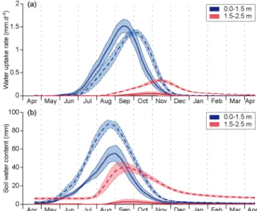
However, when considering the corresponding ratio to con-comitant rainfall (Fig. 6b), a general V-shape is obtained for evaporation, from ∼ 0.8 at the beginning and the end of the season, down to a low of 0.5 (fallow) or 0.4 (millet) at the monsoon peak. The shape is essentially opposite for the runoff ratio, in the range of 0–0.2 (lower for the millet field than the fallow), albeit with a double peak: an absolute high in the second half of July (cf. secondary rainfall peak, above, and peak rain intensity in Fig. 2a) and a relative high in late September, separated by a relative low at the monsoon peak. As transpiration is strongly buffered by the whole soil/vegetation system, it displays a very smooth course (Fig. 6a), lagged relative to rainfall by about 1 month for the fallow and 1.5 months for the millet system, and peak-ing around 1.5 mm day−1(slightly higher for the millet sys-tem). The lag in millet field transpiration is to be linked with the late phenological development of this ecosystem (Fig. 3), due in part to shrub management in the mixed crop–shrub farming. It is worth noting, however, that transpiration in the millet field peaks not only well after soil water content (stor-age inversion in Fig. 6a), but also slightly after LAI, with a growing contribution of the deep root zone (Fig. 8a). This may be traced both to (i) the downward extension of root extraction capacity that continues in that period – with shrub regrowth – in a wet subsoil (Fig. 8b) and (ii) maybe more im-portantly, the dynamics of the energy budget, with sustained global radiation but vanishing soil evaporation, allowing for higher density of transpiration flux per unit leaf area.
Drainage from the millet plot at 4 m depth starts later than all other fluxes (around the beginning of September), peaks in October with limited intensity (maximum: 0.3 mm day−1),
and recedes slowly over the dry season. Until nearly the end of September, all “consumptive” fluxes (runoff, evaporation, transpiration, but not drainage which has just started) are sub-stantially lower at the millet site than at the fallow, implying much higher storage/lower destorage up to then. This results in much higher soil water content in the millet plot through-out the average year, as illustrated by Fig. 8b for the root zone.
3.2.2 Energy
Due in particular to intertropical latitude and concomitance of the astronomical summer with the cloudier monsoon sea-son, global radiation shows only limited seasonality (230– 275 W m−2range in the average year), with two lows at
win-ter solstice and peak monsoon, an absolute high in March, and a relative high at the end of September (Fig. 7a). Yet sea-sonality is strong for all consumptive – radiative or turbulent – components of the energy cycle, and is essentially driven directly or indirectly by the single-pulse monsoon and asso-ciated water cycle dynamics. Only ground heat flux exhibits a bimodal response, but with small amplitude (±4 W m−2). Direct control by water occurs mostly through latent heat, whose dynamics shows among all energy components (i) the
Figure 8. Estimated mean seasonal courses of (a) water uptake by
plant roots and (b) soil water storage (above θr), separately in two
active root zone layers (depths in legend) for fallow (solid lines) and millet (dashed lines) plots. See Fig. 6 for further explanation of curves and colored intervals.
largest amplitude, peaking at ∼ 110 and 90 W m−2 for the fallow and millet plots, respectively, and (ii) the shortest du-ration: latent heat vanishes very quickly in the dry season for the fallow, and ∼ 2 months later in the millet field. Soil mois-ture also directly impacts the ground heat flux and albedo via soil thermal conductivity and color, respectively. Indi-rect water impact is that of vegetation on latent heat and albedo. Combined direct and indirect water effects on albedo (Fig. 7b) result in further reduction of net shortwave season-ality (not shown). Due to the stronger dynamics of soil evap-oration compared with canopy transpiration (Fig. 6a), latent heat peaks concomitantly with the former, during transpira-tion rise, even for the fallow. The time offset for transpiratranspira-tion results in a longer recession of latent heat – especially for the millet field – relative to soil evaporation alone.
As the monsoon sets in, consumption by latent heat of a major part of the net shortwave energy (more than half at monsoon peak, even for the less-consuming millet plot) carves a corresponding hollow in the courses of both net long-wave and sensible heat (Fig. 7a) through the lowering of surface temperature. These hollows are modulated in their amplitude and timing by other atmospheric controls, such as air humidity for net long-wave radiation (making LWnet
start decreasing by early April, i.e., before rainy season on-set and peak temperature, thereby offon-setting increased solar interception by the atmosphere) or wind regime for sensible heat. Sensible heat and, to a much lesser extent, ground heat reflect a combination of these different forcings, suggesting they are more dependent than all previous fluxes on the inter-play between the various land surface forcings and processes. Further illustrating the relative prominence of monsoon
pro-cesses over incoming solar radiation, net radiation follows a relatively simple course with a long rise (late December– early September) and a short recession.
The energy cycle dynamics is overall sharper and more pronounced for the fallow plot, generally displaying a some-what earlier timing. For example, like latent heat, net radia-tion is higher (lower net long-wave) in the fallow until late September, and vice versa until the next monsoon (∼ end of April). The evaporative fraction (the part of latent heat in to-tal turbulent heat flux, Fig. 7b) reaches around 0.9 in Au-gust in the fallow, versus less than 0.7 in the millet field. Differences in sensible heat are shorter in time, with more pronounced extrema (high in May, low in August) for the fallow.
4 Discussion
4.1 Results significance
4.1.1 Representativity of study sites and period
To our knowledge, this study is the first attempt to put for-ward a climatological view of GAI energy and water fluxes in the Sahel environment. While only two sites are consid-ered in this study, a fallow bush field and a rainfed millet field, these are quite representative of dominant ecosystems in the Sahelian agricultural context. This not only applies to southwestern Niger but also to a very significant part of the whole sub-Saharan Sahelian belt. Variations obviously exist within this huge domain, depending e.g. on geology, mon-soon specifics, population, and agricultural practices; how-ever, the first regional flux–site intercomparisons (Merbold et al., 2009; Sjöström et al., 2011, 2013; Lohou et al., 2014) ev-idenced strong similarities over the Sahelian domain, relative to the other ecoclimatic domains of tropical Africa. Hence, it is believed that the new results obtained at these two sites can serve as a useful reference well beyond the study area.
Previous studies (e.g., Braud, 1998; Verhoef et al., 1999; Miller et al., 2009; Ramier et al., 2009; Saux-Picart et al., 2009a) provided specific experimental and/or modeling re-sults for surface fluxes in such ecosystems over much shorter periods, i.e., at scales ranging from a single event to at most an annual cycle. For instance, Miller et al. (2009) made a detailed field analysis of the surface energy balance at sub-seasonal to sub-seasonal scales, based on a 1-year record at a Niamey fallow site, i.e., in conditions very similar to ours. However, in light of the 7-year series studied here, it ap-pears that the quite dry observation year (375 mm) at their site produced substantial flux anomalies, e.g., comparable latent and sensible heat fluxes at the heart of the rainy sea-son. Such results could be misleading if they were consid-ered alone. Conversely, the season analyzed by Ramier et al. (2009) was unusually wet (580 mm). This underlines the need for multiyear series to derive major features of surface
response to variable monsoonal forcing. The unprecedented length of our study period for this region is a step in that di-rection. Seven years is probably a lower limit for producing robust results. However, it seems a reasonable length in light of the rather small statistical uncertainty on estimated vari-ables. Comparison of rainfall statistics for the 7-year period (interannual mean and variability, seasonal distribution) with longer records for the catchment (Ramier et al., 2009) or for the area (Lebel and Ali, 2009) suggests that our study period is quite representative of current monsoon conditions in the central Sahel. Accounting for non-stationarities in climate or in the hydro-ecosystem (land cover, soil) or for land manage-ment variability (e.g., crop/fallow rotation, cultivation prac-tices, animal grazing/manuring) is another challenge facing the long-term observatory in the Wankama catchment (Cap-pelaere et al., 2009). Now that a seemingly robust model has been developed for these ecosystems, it will be interesting to investigate additional years as more meteorological and phe-nological forcing data become available.
4.1.2 Model versus data
It was suggested in the introduction that the study’s objec-tives could not be met with field data alone. This section further examines the need for and merits of the model– data integration performed. As mentioned, field data limi-tations include (i) not all variables of interest being moni-tored (e.g., evapotranspiration partitioning, runoff, drainage), (ii) substantial, unevenly distributed gap rates (one-fourth to one-third of turbulent fluxes observations missing here after data filtering, depending on variable and site, and 11 to 18 % for other energy fluxes), and (iii) measurement representativ-ity and accuracy issues, including scale discrepancies.
“Black-box” gap-filling techniques do exist, but they boil down to very basic data modeling, with crude hypotheses, which themselves may induce considerable errors and biases. Even when more elaborate modeling is achieved as it is here, observational shortcomings as well as likely statistical bi-ases in deriving a climatology from a heterogeneous series of gap-filled observations severely question the basic gap-filling approach. Using instead the physics-based model simulation for the whole reference series, provided it is constrained by successful calibration/validation with dense and diverse ob-servations through the whole simulation period, better inte-grates all sources of information into a homogeneous, coher-ent series. Specifically, it allows to (i) make all available field information work together (across variable types and over time) instead of separately, (ii) constrain them with physical principles for regularization rules to find the best compro-mise and make the most sense of all these different types of information/knowledge, and (iii) produce output variables at a consistent plot scale, obeying known physics, and as com-patible as possible with the whole data set.
Attempting to match a long and diverse set of observa-tions – all high-resolution surface energy fluxes, soil
mois-ture/temperature profiles – with a rather complex model, could be seen as quite a challenge. Results show that this is feasible for the two ecosystems and the variable forcing conditions (Appendix B), with parameters assigned in part from prior knowledge from the field and the literature, and in part from split-sample calibration/validation (2 and 5 years, respectively). This was performed with a heuristic parameter adjustment method, based on expertise with the model, the data, and the field properties and processes (Appendix A). In the authors’ judgement, the compromise achieved in in-tegrating the various data and regularization constraints is about the best possible. Some parameter equivalence does exist; however, because of the strong conditioning by the wide range of control variables and simulation conditions, including those for validation, this should not unduly affect the simulated trajectories. In this study, model application is restricted in time to the observation period, which avoids ex-trapolating to weakly conditioned situations. However, the calibrated model is thought to have the potential for reliable simulations well outside the observed conditions. Regarding unobserved fluxes, the fact that they may often occur sepa-rately in time (runoff during rainstorms, evaporation in the early rainy season, transpiration during dry spells and in the early dry season) makes calibration/validation of their main controlling parameters, and hence their simulation, all the more reliable.
These key methodological issues are further discussed in Velluet et al. (2014).
4.1.3 Timescales of seasonal cycle analysis
Strictly speaking, because of the 30-day filtering applied to the simulated time series, the mean seasonal cycles produced (Figs. 6–8) pertain to moving monthly quantities. However, the very smooth variations to be expected for the population’s mean cycles should imply low sensitivity of the latter to a time resolution below 1 month. Hence, it is believed that the estimated seasonal courses of Figs. 6–8 provide rather good climatological estimates for finer timescales as well, down to daily resolution. For this finest resolution, only the peaks (highs and lows) would be expected to be slightly smoothed out (underestimated maxima, overestimated minima). To get an idea of the possible differences between the population’s daily and running monthly mean seasonal cycles, we can simulate their relationship by applying a 30-day filter to the estimated seasonal signals of Figs. 6a and 7a: this reduces the seasonal standard deviation of water cycle variables by only 2 % (for soil evaporation) to 5 % (for runoff), and by 1.5 % (net long-wave or latent heat) to 3 % (sensible heat) for all energy variables but global radiation and ground flux (∼ 7 %). Note that these figures are quite stable with respect to recursive filter application, suggesting a robust approach. To obtain more rigorous, direct/unbiased estimates for the daily resolution, a record of considerable length would be needed to filter out sampling-induced high-frequency noise
and ensure acceptable standard estimation error. To reach at all times the same order of statistical uncertainty as with the estimations presented here, the required length is evaluated to vary from ∼ 15–20 years for soil water storage or drainage in the millet field to several centuries for rainfall, runoff, ground heat flux, or reflected shortwave (with > 2 decades for plant transpiration, > 3 decades for net long-wave radia-tion, and 6–10 decades for soil evaporation and all turbulent heat fluxes).
Finally, as only the systems’ mean behaviors are doc-umented here, variability around climatological means is not reflected. For instance, dry spells commonly occurring within the Sahel monsoon are not shown explicitly but only through their effects on the mean seasonal signals. Thus, it should be kept in mind that, at any timescale (daily to an-nual), some of the features highlighted by this first-order analysis may not hold at all times, and that they can even turn out to be the opposite under certain circumstances.
4.2 Insights into some key GAI processes
This discussion focuses on water cycle processes, as they were shown to also largely condition the other GAI processes in this environment (Sect. 3.2.2).
4.2.1 Runoff/infiltration, soil storage and drainage
Runoff values for the two sites are compatible with results from previous field plot studies in the area (e.g., Peugeot et al., 1997; Estèves and Lapetite, 2003). They show high variability, with annual runoff spanning a range of ∼ 120 % of mean for both sites, and annual runoff coefficient rang-ing 5.6–18.8 % for the fallow and 2.6–13.3 % for the millet plot. High runoff from the fallow is due in particular to a low hydraulic conductivity and high retention in the thin sur-face horizon (H1), representing the soil crust observed in the field. Lower runoff from the millet field is largely due to the comparatively higher conductivity/lower retention of its own H1 horizon. However, a sharp contrast with the underlying sandy soil (H2–H5 horizons) is also found, confirming that some degree of superficial restriction of infiltration/crusting subsists despite cultivation (Rockström and Valentin, 1997), even if infiltrability is significantly improved.
These differences in rain infiltration capacity between the two plots appear to be one cause for the consistently higher soil water storage obtained for the millet field, but not the only one. The other one – even more important, as hypoth-esized by Ramier et al. (2009) – appears to be lower evapo-transpiration from the millet field, at least until late Septem-ber (Fig. 7a). On average, these two factors account for, re-spectively, about one-third and two-thirds of the difference in 0–4 m soil storage up to that date. Direct soil evapora-tion dominates in this evapotranspiraevapora-tion contrast; however, both soil evaporation and rainy season plant transpiration are lower in the millet field despite generally higher soil
mois-ture. Hence, it appears that a combination of factors leads to higher soil water content in the millet field all along the wet season (and hence throughout the whole average year, Fig. 8).
Consequences of this higher water storage are that when the end of the rainy season approaches, drainage can start to occur at the 4 m depth in the millet field – at least in suffi-ciently wet years – as well as shrub regrowth that sustains transpiration into the dry season. This is not the case for the fallow. Even though drainage amounts to a modest fraction of the plot water balance, the average 31 mm yr−1estimated un-der the millet field (plus the 8 mm yr−1of net soil storage, es-sentially below the root uptake zone) represents a significant potential recharge source for the unconfined aquifer, given the considerable fraction of land now cropped (e.g., Leblanc et al., 2008). Due to the low water table (∼ 30–40 m at the study site; Massuel et al., 2006; Descroix et al., 2012), soil drainage should take years or even decades to actually reach the saturated zone (Ibrahim et al., 2014). Hence, water infil-trated after the extensive clearing of recent decades may in the future contribute to sustain very significantly the current rise in the water table, attributed mainly to enhanced indirect recharge via runoff to surface ponds (Favreau et al., 2009).
4.2.2 Evapotranspiration and its partitioning
During most of the year, evapotranspiration appears to be water-limited, with the latent heat flux being tightly con-nected to variations in soil water and rainfall. Only at the monsoon peak (August–beginning of September) does the evaporative fraction (Fig. 7b) or the ratio to reference evapo-transpiration (Allen et al., 1998; not shown) approach 1, sug-gesting that evapotranspiration becomes then more energy-limited. Both ratios peak higher for the fallow, despite lower total soil moisture.
On average over the study period, estimated transpiration amounts to ∼ 32 % of total evapotranspiration at the fallow site and ∼ 40 % at the millet site. This is a little more than that obtained for the same fields by Saux-Picart et al. (2009b) with the SEtHyS_Savannah model (∼ 27 and 31 %, respec-tively), but for a 2-year period with higher average rain-fall. Simulated millet transpiration is consistent with field estimates during the peak growth season at a nearby site (< 20 km; Soegaard and Boegh, 1995). Relatively small con-tributions have been reported for transpiration from the shrub layer in fallows (Brunel et al., 1997; Tuzet et al., 1997). Al-though no direct continuous observation of this partitioning of evapotranspiration into plant transpiration and soil evap-oration is available at the two study sites, the fact that one and only one of these two components is negligible at certain times of year (transpiration in the early rainy season before LAI actually starts; evaporation after the rainy season) en-ables validation of the other component through total evapo-transpiration for those periods.
The increase in transpiration in the late monsoon when soil evaporation declines (Fig. 6a; especially for the millet system where soil moisture is still high) is interpreted partly as reflecting a relaxed competition for energy between the two processes. Note that the climatic water demand, as ex-pressed by reference evapotranspiration, does not rise again after its monsoon low until the winter solstice. A corollary phenomenon, with soil evaporation bursts that appear to de-press plant transpiration, is noticeable at smaller timescales, just after rain events. In the following days, transpiration re-covers as evaporation declines (also reported by Braud et al., 1997), suggesting that evaporation extinction – for lack of shallow soil moisture – makes energy available for more plant transpiration.
Our results temper the Miller et al. (2009) suggestion that the seasonal course of evapotranspiration is driven primar-ily by the contribution of plants to atmospheric moisture in this environment. They also temper the hypothesized benefit that plants could draw during a growing season from subsur-face moisture accumulated during the previous rainy season: while this does happen in our simulations for the millet field vegetation in the months just after the rainy season (∼ 7 % of rainfall, on average; Figs. 5a, 6a and 8a) and possibly to a limited extent for moisture carried over from one monsoon season to the next in the 1.5–2.5 m depth range (Fig. 8b), no comparable benefit appears for the fallow in this study.
Partly due to the late wet season/early dry season shrub re-growth in the millet field, the general picture of higher evap-otranspiration from a fallow ecosystem than from a millet field (Gash et al., 1997; Ramier et al., 2009) is also some-what moderated by our results. In this study, this is true on average during most of the rainy season (Fig. 6) – despite generally lower soil moisture – but not in the late September– January period, making annual totals turn out very simi-lar (fallow slightly above). Also, when considering interan-nual variability, rankings may revert both aninteran-nually and/or at some periods of the wet season, likely in relation with higher short-timescale variability in transpiration for the fal-low. This larger variability can be traced both to the lower and more variable soil storage (Fig. 8b) that makes fallow vege-tation more exposed to rainfall shortage, and to the higher LAI variability (Fig. 3) reflecting higher ecosystem sensitiv-ity to environmental conditions (Boulain et al., 2009a) and exposure to external factors such as pasturing.
Finally, our results also suggest that these contrasts in wet season evapotranspiration between the two ecosystems orig-inate at least partly from differences in generation of di-rect soil evaporation, which is clearly enhanced in the fallow field. Hence, higher rainy season evapotranspiration from the fallow may not (only) be related to plant physiological ef-fects on transpiration, but maybe more importantly to the physics of direct soil–atmosphere exchanges within these two ecosystems (e.g., differences in convective “shield” ef-fect, cf. Tuzet et al., 1997, or in shallow soil properties).
Whether this conclusion can be generalized requires further analysis.
5 Conclusions
The purpose of this work is to build upon a unique, multi-year record of local water and energy observations for two typical plots in southwest Niger in order to propose, for the first time, a climatology of these processes in the Sahel re-gion. The methodology relies on the development of a de-tailed, physically based GAI column model that is finely calibrated/validated against this important data set. It pro-vides a time- and depth-continuous series of all water and energy variables involved, over a full 7-year period. This in-cludes unobserved variables, most notably direct soil evapo-ration, plant transpievapo-ration, runoff, and drainage. The model, forced with observed meteorology and phenology, is cali-brated against 2 years of data and evaluated against the full 7 years, showing very good skill in reproducing the whole ob-servation record. For instance, the model is able to reproduce faithfully the observation of larger evapotranspiration in the fallow than in the millet plot during most of the rainy season despite lower soil moisture. The variety of monsoon condi-tions encountered and of evaluation variables used – cover-ing the full surface energy balance (short- and long-wave ra-diation, turbulent fluxes, soil heat flux) and 2.5 m deep soil moisture and temperature profiles – offers a comprehensive set of constraints that ensures a reliable model trajectory.
The time series simulated for all water and energy vari-ables are analyzed statistically at several timescales: an-nual and seasonal aggregates, and seasonal cycles of run-ning monthly to daily values. A detailed documentation of climatological mean water and energy cycling, with sample-related uncertainty, is thus produced. From this analysis, new insights are derived on the interplay between processes that corroborate, refine, or question some ideas proposed so far in the literature. Uncertainty sources other than time sam-pling are not considered quantitatively in this study, as this requires elaborate assumptions to be made for all possible error sources, which is an upcoming step in this project.
With evapotranspiration/latent heat representing over 80 % of the mean annual water budget and nearly half the energy budget in peak monsoon, the case for studying these two strongly coupled cycles jointly, and for resolving this cou-pling explicitly, is thus clearly strengthened for the Sahel re-gion. The atmospheric vapor flux is shown to be dominated by direct soil evaporation during most of the monsoon sea-son in the average year. Plant transpiration becomes domi-nant only in the last part of the wet season (from the second half of September) and continuing into the beginning of the dry season.
Differences between the two land cover types are substan-tial for most components of the water budget. For instance, differences in estimated annual mean runoff (∼ 45 and
∼70 mm yr−1for the millet and the fallow, respectively) and drainage (∼ 30 mm yr−1 and nil, respectively) may induce potentially important land use effects on water resources. Nearly all the climatological water fluxes considered are higher in the fallow plot until around the end of September, and over the whole wet season for runoff and soil evapora-tion; conversely, soil storage, drainage, and dry-season plant transpiration are always larger in the millet field. Differences are somewhat smaller for the energy cycle, with generally more pronounced dynamics in the fallow plot.
These qualitative and quantitative results should prove useful as a reference field information for various purposes such as evaluating and improving land surface models and remote sensing algorithms in the framework of the current ALMIP-2 project2 (Boone et al., 2009b). To our knowl-edge, the study presented here represents one of the most extensive analyses of local field-scale water and energy cy-cling performed for the Sahelian context to date, associating both a unique data set in length and quality and a very de-tailed, finely calibrated model. This climatological analysis is currently being extended to sub-seasonal variability around mean behavior, with the aim of providing comprehensive sta-tistical signatures of surface fluxes to serve as reference for land–atmosphere studies. Observations are continuing at the Wankama site to extend model evaluation information, in-cluding to other land cover types, and to evaluate effects of land management practices on the water and energy balances (Cappelaere et al., 2009). Finally, as argued strongly in the discussion, it is believed that the unconventional approach used to combine all sources of information available into a homogeneous reference series through extensive model–data integration is the best way to produce the desired climatolog-ical characterization. The model properties and qualities also encourages its use for making projections beyond the study conditions (Velluet, 2014).