Publisher’s version / Version de l'éditeur:
PERD/CHC Report 31-27, 2001-06
READ THESE TERMS AND CONDITIONS CAREFULLY BEFORE USING THIS WEBSITE. https://nrc-publications.canada.ca/eng/copyright
Vous avez des questions? Nous pouvons vous aider. Pour communiquer directement avec un auteur, consultez la
première page de la revue dans laquelle son article a été publié afin de trouver ses coordonnées. Si vous n’arrivez pas à les repérer, communiquez avec nous à [email protected].
Questions? Contact the NRC Publications Archive team at
[email protected]. If you wish to email the authors directly, please see the first page of the publication for their contact information.
NRC Publications Archive
Archives des publications du CNRC
For the publisher’s version, please access the DOI link below./ Pour consulter la version de l’éditeur, utilisez le lien DOI ci-dessous.
https://doi.org/10.4224/12340895
Access and use of this website and the material on it are subject to the Terms and Conditions set forth at
Surficial Sediments, Grand Bank, Offshore Newfoundland
Sonnichsen, G.; King, E.
https://publications-cnrc.canada.ca/fra/droits
L’accès à ce site Web et l’utilisation de son contenu sont assujettis aux conditions présentées dans le site LISEZ CES CONDITIONS ATTENTIVEMENT AVANT D’UTILISER CE SITE WEB.
NRC Publications Record / Notice d'Archives des publications de CNRC:
https://nrc-publications.canada.ca/eng/view/object/?id=59f344a6-15a2-452b-86aa-f2b8d5e7844d https://publications-cnrc.canada.ca/fra/voir/objet/?id=59f344a6-15a2-452b-86aa-f2b8d5e7844d
SURFICIAL SEDIMENTS, GRAND BANK, OFFSHORE NEWFOUNDLAND
Technical report to
Dr. Garry Timco Canadian Hydraulics Centre National Research Council of Canada
From
Natural Resources Canada, Geologic Survey of Canada Atlantic Gary V. Sonnichsen and Edward L. King
Gary V. Sonnichsen and Edward L. King, Natural Resources, Canada, Geological Survey of Canada (Atlantic), Bedford Institute of Oceanography, 1 Challenger Drive, P.O. Box 1006, Dartmouth, Nova Scotia B2Y 4A2; [email protected];
Garry Timco, Canadian Hydraulics Centre, National Research Council of Canada, Ottawa, Ont. K1A 0R6 Canada, [email protected]
Executive Summary
Seabed scouring by icebergs is an impeding factor to the production and transshipment of oil and gas on Grand Bank. Understanding the seabed response to iceberg impact is essential for safe and cost-effective design of subsea facilities. Until now, a regional characterization of seabed sediments and engineering properties at a practical scale has been lacking. A new surficial geology zonation is presented here together with a brief geological setting, description, and geologic unit distribution. Existing geotechnical measurements are sparse and many are extrapolated from outside the map area but grain size, density, water content and strength values are presented for most sediment units. Values vary widely, reflecting the nature of the sediment and differing depositional processes and post-depositional history.
Most of the Grand Bank seabed is covered by a relatively hard till sediment (sub-glacially deposited clay to boulder range), the Grand Banks Till Formation. This originated from glacial ice cover, likely in more than one phase, the latest lasting from about 25,000 to 14,000 years before present. The Formation deposited locally in long moraine ridges and its upper surface was modified by relict icebergs and current action, creating an undulatory (1 to 3m relief) gravely or sandy gravel seabed. Reported shear strengths are as low as 20 kPa for young, unmodified deposits and as high as 515 kPa for old, glacially overridden and desiccated samples, but most seabed exposures probably range from 75 to 110 kPa.
In deep-water areas (generally over 300 m) and in small, isolated basins, suspension-deposited
glaciogenic silt-dominated deposits, Downing Silt Fm., overly the till: Deposits range from a few to tens of metres thick. The Downing Silt was deposited largely beyond the ice margin during retreat phases. Strength measurements from 10 to 35 kPa probably characterize the near-surface. Some have been extensively iceberg scoured but this is mainly from times of lower sea-level and abundant glacier calving. The modern iceberg regime is unlikely to impact these silts. The same holds for the overlying clay
dominated muds of the Placentia Clay Fm. A sandier sub-unit of the Downing Silt occurs in water depths more likely to be scoured. Measurements are largely lacking in the Downing Silt, but relict scours
dimensions are similar to those in the till at its deeper extents. The shallower extents are probably sandier and preserve fewer, shorter, and shallower scours.
The Grand Banks Till and Downing Silt Formations are covered with a veneer of silty sand, Adolphus Sand, over an extensive area between about 100 to 150 m water depth, deposited as near-shore sands below the former low stand of sea-level. This unit reaches up to several metres thickness but generally is thin enough that icebergs can potentially penetrate to the underlying substrate. The Adolphus Sand has only one reported shear strength of 20 kPa.
Washed sands and gravels of the Grand Banks Sand and Gravel Fm are widespread above 105 to 110 m water depths. They were subjected to coastal and shallow water processes as sea-level rose over the last 15,000 years. The rounded gravel locally overlies thin and/or patchy till deposits from which it derived through erosion and reworking. Where the till unit has been completely eroded, the gravel lies on older and partially consolidated marine sands and silts. Gravel thickness is not well documented but likely varies from several cm to 1 or 2 m. The gravel is overlain by medium and coarse sands of highly variable thickness (up to 10 m) and distribution. Cone resistance that is typically <15 Mpa characterizes these cohesionless soils. Engineering properties vary greatly, reflecting local heterogeneity. The surficial map and accompanying illustrations attempt to characterize this variability, where data control is available
TABLE OF CONTENTS
EXECUTIVE SUMMARY
2
1.0 INTRODUCTION
4
1.1 Regional Setting of the Grand Banks
5
1.1.1 Physiography
5
1.1.2 Regional Geology
6
2.0 SURFICIAL SEDIMENTS
9
2.1 The surficial geology map
9
2.2 Grand Banks Till
10
2.2.1 Ground Moraine
11
2.2.2 Terminal Moraines
12
2.2.3 Engineering Properties of the Grand Banks Till
13
2.2.4 Avalon Channel
14
2.2.5 Jeanne d’Arc Basin
15
2.2.6 Halibut Channel
16
2.3 Downing Silt
17
2.3.1 Engineering Properties of the Downing Silt
19
2.4 Adolphus Sand
20
2.4.1 Engineering Properties of the Adolphus Sand
20
2.5 Grand Banks Sand and Gravel Formation
21
2.5.1 Engineering Properties of the Grand Banks Sand and Gravel
22
2.6 Placentia Clay
23
2.7 Iceberg scour and sediment type relationships
24
3.0 CONCLUSIONS
25
4.0 REFERENCES
27
1.0 INTRODUCTION
Grand Bank, offshore from eastern Newfoundland, is actively undergoing hydrocarbon production and exploration. By 2004, three, and possibly four oil production projects will be in production, with proven reserves in excess of a billion barrels. Future discoveries and development of satellite fields will
undoubtedly increase the number of projects. Additionally, while all production plans to date have been exclusively oil, there is heightened interest in the development and trans-shipment of natural gas from Grand Bank. Feasibility assessments for regional pipelines have been initiated by both the Newfoundland government and by private consortia. Since construction of the Hibernia Gravity-Based Structure (GBS), Terra Nova and White Rose partners have opted for floating production designs and the associated subsea facilities such as well heads, manifolds, and flow lines. The reliance on subsea production
increases the risk of exposure to the effects of modern marine processes affecting seabed stability such as sediment transport and seafloor scouring by ice. A detailed understanding of the distribution and physical properties of seabed and near surface sediments is therefore necessary to ensure safe, cost-effective exploration and exploitation of marine hydrocarbon resources.
In this report, we present a new compilation of the surficial geology for northern Grand Bank, including
the Jeanne d'Arc Basin region from Flemish Pass inshore to and surrounding the Avalon Peninsula and the southern part of Northeast Newfoundland Shelf (Fig. 1). The surficial sediment units are described in terms of their geometry and distribution and the geologic processes responsible for their deposition and subsequent modification. They are then characterized by their sediment physical properties, including sediment grain size, and where possible, their geotechnical aspects. The chosen map area encompasses the known significant discoveries on Grand Bank, and also that portion of Grand Bank likely to be crossed by future transshipment pipelines to Newfoundland. The mapped distribution of Grand Bank surficial sediments is reconnaissance-level in both scale and resolution. The broad geographic coverage and relatively sparse geological control dictates generalization and extrapolation. Accompanying illustrations depict the local seabed variability at a smaller scale in a few examples.
The surficial sediment distribution was interpreted from regional GSC high resolution seismic reflection data (primarily Huntec Deep-Tow System (Huntec DTS™) boomer and sparker profiles (Fader and King, 1981; King and Fader, 1986; Fader and Miller, 1986a and b; Lewis et. al., 1987; Sonnichsen, et. al. 1994)
and from regional sidescan sonar profiles and site specific sidescan sonar mosaics collected by industry and GSC. Sediment thickness for the uppermost surficial sediments has been interpreted from the
profiles. Surficial sediment texture and physical properties have been extrapolated from isolated surficial grab samples, seabed photos and the upper samples from industry geotechnical boreholes. Within the Jeanne d’Arc Basin, high quality geotechnical soil measurements for the upper 5 m were extracted from published and unpublished reports of borehole results at Terra Nova, Hibernia, and Ben Nevis.
Boreholes and cone penetrometer data from 13 boreholes along a proposed southern pipeline route provided the only direct physical property data on Grand Bank sediments outside the Jeanne d’Arc Basin. Seabed features and processes are also described.
1.1 Regional Setting of the Grand Banks 1.1.1 Physiography
The continental shelf off eastern and southern Newfoundland has 3 physiographic zones (Fader and Miller, 1986a):
• an inner shelf of rough, undulating relief underlain by resistant Pre-Cambrian bedrock with channels filled with glacial sediment;
• an inner-central zone of longitudinal, broad depressions (e.g., Avalon Channel, and its extension, St. Pierre Channel); and
• an outer shelf of large, shallow banks separated by transverse saddles.
The six banks on the continental shelf off Newfoundland are collectively referred to as the Grand Banks of Newfoundland. Grand Bank is the largest, with an area of more than 100 000 km2, and it represents the eastern and southernmost portions of the Grand Banks. The surface of Grand Bank is relatively flat and slopes gently from shallow water (< 5 m) near the centre of the Bank (Virgin Rocks- Eastern Shoals) to about 100 m along its perimeter (Fig. 1). Surface morphology becomes more irregular in the southern and northwestern parts of the bank. Avalon Channel, locally up to 200 m deep, separates Grand Bank from the island of Newfoundland. To the east, Flemish Pass, with depths greater than 1000 m, separates Grand Bank from Flemish Cap, which rises to within 140 m of the ocean surface. Grand Bank is bordered to the north by Downing Basin, and a broadened Avalon marginal channel. To the west, elongated discontinuous depressions of Whale Deep separate Whale Bank from Grand Bank. North of
the Grand Banks is the southern portion of the Northeast Newfoundland Shelf, much of which lies between 100 and 350 m water depth. Trinity Trough is a transverse trough extending across the shelf
from Trinity and Bonavista Bays at the northern edge of the map. South of Trinity Trough, a region of highly dissected/channeled seabed on the central shelf locally reaches to 300 m depth.
The Hibernia, Terra Nova, and White Rose hydrocarbon discovery areas are all located on the
northeastern edge of Grand Bank. Above the 80 m isobath, the seabed is relatively flat while below, the contours are relatively smooth and sub-parallel with the exception of a ridge and valley morphology in the central north. The shelf break occurs at approximately 220 m (Piper and Pereira, 1992), but at nearly 400 m near Sackville Spur and 300 m just south of Trinity Trough.
1.1.2 Regional Geology
The stratigraphic column in Figure 2 provides an overview of the range in rock and sediment types, thickness and ages within the map area. Emphasis is placed here on the shallow and surficial units potentially impacted by iceberg scouring. The sub-cropping units are largely undifferentiated in this presentation.
The shallow (< 200m) bedrock geology off eastern Newfoundland consists of inner shelf late Precambrian
crystalline/metamorphic rocks (Unit 1); Cambrian to Devonian shelf-deposited siltstones and sandstones (Unit 2) which overly the Precambrian rocks offshore, and seaward of both, a shelf-prograding sequence of Cretaceous to Tertiary (Mesozoic) age, largely poorly lithified sedimentary rocks (Unit 3) (King et. al., 1986; Fader and Miller, 1986a). These are only locally exposed at the seabed, or exposed with a thin surficial sediment veneer. These exposures are largely restricted to the nearshore areas, usually shallower than 75 m water depth. Exceptions are the Virgin Rocks and Eastern Shoals where bedrock outcrops approach within metres of the sea surface. A series of north-south, fault-bounded, Mesozoic basins are separated by basement highs on central to outer Grand Bank (Grant et. al., 1986). Overlying the fault-bound basins is a wedge of undifferentiated Tertiary clastics identified as the Banquereau Formation that thickens seaward to more than 4,000 m in the East Newfoundland Basin. The Jeanne d'Arc Basin, the southern extension of the East Newfoundland Basin where all significant oil discoveries to date have been discovered, contains up to 14,000 m of Mesozoic and Cenozoic sediments (Grant et. al., 1986).
The seismic reflection pattern for the upper 200 m of the Banquereau Formation consists mostly of low angle (<0.1 degree), eastward-dipping, parallel reflections (Fader and King, 1981). These units sub-crop
along a regional seabed unconformity (shallow bank) in broad zones across the outer bank (Sonnichsen and Cumming, 1996; Terraquest Associates, 1995; King and Sonnichsen, 1999), beneath the relatively thin Quaternary sediments which include glaciogenic sediments and transgressive surficial sands, gravels and scattered boulders. Where these overlying units are sufficiently thin, it is possible that iceberg
scouring could impact the older sediment units beneath. For this reason, and because of local soil strength anomalies in them, their differentiation is included in this report. King and Sonnichsen (1999, 2000) divide these shallow Banquereau Formation strata into four unconformity-bound units:
• Unit 1: Upper Parallel Reflection Sequence:
! largely conformable marine shelf aggradation of sandy silts and clays.
! Divided into 5 sub-units based on recognition of regional erosional unconformities. • Unit 2: Clinoform Reflectors: including an upper
! Unit 2A encompassing the sandy clinoform body (“delta”) and its distal finer-grained equivalents, And a lower
• Unit 2B comprising a less well defined depositional complex but including rare sandy clinoforms and probably related to the younger delta.
• Unit 3: Lower Parallel Reflection Sequence:
! conformable shelf aggradation with minor unconformities
• Unit 4: Older progradational (sandy) unit with lower angle distal equivalents ! Unit 4 surface is eroded and small channels attest to subaerial exposure.
The sequence is the result of numerous fluctuations in sea-level and consequent exposure to shallow marine or terrestrial conditions. The age of Units 1 to 4 remains uncertain. Limited biostratigraphic evidence from boreholes in the Hibernia area, constrain the age of the parallel reflection sequences to Late Tertiary or younger. The regional seismostratigraphic setting suggests Late Tertiary and early Quaternary age (King and Sonnichsen, 1999).
Glacial ice once covered most of the map area. Whether or not the last glaciation covered the outer bank remains uncertain. Well-rounded boulders, channels cut into bedrock and filled with glaciogenic sediment, and exotic gravel lithologies within the surficial sands in the Jeanne d’Arc region were described as
evidence of previous glaciation of the Grand Banks by King and Fader (1986). Tills on the outer shelf edge have been attributed to glacial ice that crossed the outer Grand Banks in the early Wisconsinan
(Fader and Piper, 1990) with a Late Wisconsinan ice margin placed about mid-shelf. King and Sonnichsen (1999; 2000) mapped a series of long, low moraines across northeastern Grand Bank, informally named the Sackville Moraine complex. This series of end-moraines provide evidence for a glaciation across all of northeastern Grand Bank. Glacial deposits are not thick enough to be recognized seismically above the regional unconformity in the (shallower) Jeanne d’Arc region and there is no surficial morphological expression west of the Sackville Moraine complex. However, glacially derived sediments have been reported in borehole excavations at Hibernia and Terra Nova. The glacial sediments are thought to be thin and discontinuous due to erosion during the marine transgression following the –105 m late
Wisconsinan low stand at ~15,000 ka. The erosion and coastal reworking would have modified much of the pre-existing glacial till into the surficial sands and gravels.
As noted above, much of Grand Bank was affected by subaerial and coastal processes during the Late Wisconsinan low sea-level stand (ca. 105-110 m below present) and subsequent sea-level rise. Wave erosion and reworking would have eroded any surficial glacial deposits or modified them beyond recognition (Fader and Miller 1986a, Barrie et. al. 1984). Recently, King and Sonnichsen (2000)
speculated that an older sea-level low stand might have extended to 150-160 m below present sea-level. This would have broadened the zone of subaerial erosion and transgression on Grand Bank significantly. At present, the evidence for this low stand is the abrupt truncation of the N-S trending glacial moraines at depths shallower than 160 m water depth and broad erosional incisions on NE Grand Bank which reach down to 160 m and might represent drowned river valleys. Alternatively, a pro-glacial isostatic bulge may have raised the seabed into a strong wave base environment, thus eroding them during the last glaciation.
Sea-level lowstands, in addition to modifying/eroding deposits, also provided periods of subaerial exposure during which surface weathering may have produced diagenetic soil characteristics including
caliche or “hardpan”-like horizons as experienced in some near-seabed deposits. Associated
overconsolidation has proven problematic to drilling installations (Segall et. al. 1987, Long et. al. 1986; Sonnichsen and Zevenhuizen, 1996). An additional or perhaps alternative genesis for the
2.0 SURFICIAL SEDIMENTS
2.1 The surficial geology map
A new map of the surficial/Quaternary geology of the Avalon Peninsula to Flemish Pass has been
compiled. It represents a considerable improvement in detail over available maps. Nevertheless, given the large area and variable geographic coverage of control data, some boundaries, and stratigraphic concepts and relationships remain imprecise, poorly defined, or undifferentiated elsewhere on the map. Figure 3 shows the location of supplementary geologic profiles and maps to help characterize the geologic units and their local distributions. Compilation scale is at 1: 1,000,000. It was compiled partially from published information, unpublished maps of smaller areas, GSC Open File publications, GSC contract reports, unpublished GSC site specific surveys, and existing raw and partially compiled GSC survey and sample data including that from recent cruises. A separate reference list for the map is provided. The greatest amount of control data coverage reflects the location of hydrocarbon development industry interests on the outer shelf between 80 and 120 m water depth. The extra detail here reflects this. In contrast, vast areas of the outer and central bank have very sparse information and remain largely
undifferentiated on the map. Some features and geologic relationships are highly topographic or water depth dependent and the 1:350,000 CHS bathymetric maps provided valuable control for extrapolation beyond seismic data coverage. This map has the unique attribute that some thin surficial units (specifically Adolphus Sand (7) and Downing Silt (6C)) are portrayed with a degree of transparency such that the type and distribution of underlying units is conveyed. This is augmented with occasional notes indicating the surficial and immediately underlying units as well as occasional notes as to relative thickness. This is deemed useful where iceberg impacts may penetrate a surficial veneer and impact underlying sediments of a different nature. In addition, large and small-scale moraines are depicted. The larger moraines present enough relief to have an affect on grounded icebergs, perhaps with a filtering or corralling effect.
Surficial sediment type and distribution across Grand Bank is largely governed by deposits from times of glacial ice cover or proximity and the subsequent modifying effects of the low sea-level stand(s). Present-day surficial sediments above the regional unconformity are generally thin and sandy or gravely. The deeper basins are generally silt or clay filled, while large areas below the lowstand have till modified to
varying degrees. In some areas, more recent sediment transport and iceberg scour processes have modified the surficial sediments. Five main surficial sediment units have been mapped on Grand Bank
following the concepts of Fader and Miller (1986a) and King and Fader (1992): Grand Banks Till,
Downing Silt, Adolphus Sand, Grand Banks Sand and Gravel, and Placentia Clay. The units are
described from oldest to youngest in terms of the sedimentary characteristics and inferred geological processes of deposition and subsequent modification. This information is summarized in Figure 2. Detailed engineering properties for most of the units are also provided. With the premise that observed iceberg scours in the various sediment types in some way reflect their response to iceberg impact, some notes on iceberg scours are provided. However, given the complex history of sea-level and changes to
iceberg populations, this is only briefly pursued in this report.
Information regarding the thickness of surficial sediments on the Grand Banks of Newfoundland comes primarily from high resolution seismic reflection profiles collected by the GSC. Figures 4 to7 illustrate some of the nature and inter-relationships of the bedrock and Quaternary units in geologic sections. A regional map is presently being compiled depicting total Quaternary sediment thickness as measured at intervals along the seismic profiles (contoured where appropriate). For purposes of iceberg scour impact the surficial map with its “transparency” should provide satisfactory information on the sediment type potentially affected by impact.
2.2 Grand Banks Till
The Grand Banks Till (4) is a mixed-sediment of glacial origin, of poorly defined age, that overlies older bedrock units. Till, by definition, is intimately associated with sub-glacial depositional conditions and is highly variable in range of grain size and geotechnical character. It usually constitutes a diamict; a poorly sorted mixture of sand, silt and clay in a matrix supporting a large range of larger clasts ranging from granules to boulders. While till generally is characterized by a specific seismic signature, this signature is not unique to till, so some local occurrences may include sediments other than till (e.g. debris flows, iceberg turbate, immediately proglacial moraines). This is perhaps more of an academic question because the range in geotechnical character of true till is large and certainly overlaps with deposits of different genesis. It is considered likely that glacial ice has extended onto Grand Bank more than once and that present-day deposits of Grand Banks Till are the result of more than one glacial advance. These different
advances are differentiated locally in Trinity Bay and inner Trinity Trough as two or more stacked tills, an upper, and a lower, designated 4(up) and4(lw) respectively. They have a marked, smooth, intervening
glacial erosion surface (GES). The lower till is presumed to be more over-consolidated to some degree, an outcome of the GES interpretation (glacial overriding). Here, the presence of lower till exposed at the seabed is not recognized, but this may be in part because the very presence of a covering of upper till of a few metres thickness helps define occurrence of the lower till.
The same problem of differentiating older and perhaps harder tills exists on a regional scale. For example, the age and thus post-depositional modification history of the thin till blanket east of the Avalon
Peninsula is unclear with respect to the till in Trinity Trough or the till blanket on outermost Grand Bank. Also, at least two generations of major sub-glacial channel cutting are evident east of the southern Avalon Peninsula and there are indications of two till generations; the older one may be present near the seabed locally. Areas with till of unknown age/stratigraphic position are designated simply as 4. The character of the upper till must also vary locally, depending on conditions of deposition such as P, T, and water content and dynamics. The problem of characterizing the tills is compounded by the difficulty in obtaining adequate sample material. It is often covered with a gravely surface, the product of iceberg and current reworking, which makes penetration by sampling tools difficult. Despite such variability and lack of control, the nature of the till generally contrasts considerably with other units.
Grand Banks Till occurs on Grand Bank and the Northeast Newfoundland Shelf mainly as a thin ground
moraine, but also in terminal moraines, a series of recessional moraines (King and Sonnichsen, 2000) and locally as a subsurface component of channel fill (Fader and Miller, 1986a). Only surficial expressions of Grand Banks Till are addressed here.
2.2.1 Ground Moraine
The Grand Banks Till is exposed at the surface over much of Grand Bank south and east of Newfoundland in water depths greater than ~110 m (Fig. 1) as a relatively thin continuous ground moraine. Thicknesses are typically in the order of 0.5 to 15 m, although thicker deposits are found locally, in topographic lows and in terminal moraines. The thickest sediments are on the Northeast Newfoundland Shelf and parts of Avalon Channel and on the adjacent bank edges to the south. Over
much of northern and northeastern Grand Bank, the Grand Banks Till is thin. A subtle unconformable seismic reflector between 3 and 25 m depth below seabed separates the thin surficial unit from older,
eroded and truncated “bedrock” strata, and exhibits a similar acoustic character which precludes good definition of its base on seismic profiles. Till is present at the surface over much of the outer bank below ~150 m water depth. It thins south and east on the outer bank but is probably still present as thin
remnants beneath an Adolphus Sand (7) veneer up to about 110 m water depth. In contrast, till is likely thin and patchy in water depths above 100 m where “bedrock” strata extend up to the surficial sand and gravel south and west of Terra Nova and Hibernia respectively. The Grand Banks Till blanket in the Avalon Channel vicinity and out to Downing Basin and the Virgin Rocks is generally thin (1 to 3 m). Iceberg scours penetrate the till and impact the hard Cambro-Silurian bedrock below. This blanket thickens to over 10 m in the southern and northernmost part of the Avalon Channel (Fig. 5). It is generally present below younger sediments in the bays of the Avalon Peninsula.
2.2.2 Terminal Moraines
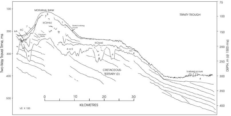
The Trinity Moraine is located about mid-shelf in Trinity Trough and spans its entire width (Fig. 1). It is up to 80 m thick with a gradually sloping landward side and a terraced seaward side, flanked with draping stratified Downing silt (6B(t)).
A broad field of linear, transverse (ribbed) moraines occurs on the southern flank of Trinity Trough, covering over 1,500 km2. They have a NNW-SSE orientation with crest to crest spacing of up to 500 m and amplitudes ranging from 10-15 m (Fig. 6). Individual crest-lines may be traced for distances of greater than 6 km on sidescan sonograms. In contrast to the Sackville Moraines, data control was
insufficient to map individual ridges. The moraine surfaces have been subjected to iceberg scouring which has strongly altered their surface morphology. A single large grab was successful in recovering
(disturbed) sample from within the Trinity Trough ribbed moraine field in what is mapped as upper till, 4(up). It comprises a red-brown, silt-clay matrix rich diamict with gravel and cobbles originating from both the Precambrian and Lower Paleozoic bedrock.
Another series of subtly elevated seabed mounds on seismic profiles in the northeastern map area (Fig. 1) can be correlated with the benefit of regional bathymetric control. The mounds form a series of linear and
bifurcating ridges whose pattern suggests a field of recessional moraines, here termed the Sackville Moraine complex. The ridge morphology is best developed on the northern ridges with relief of 10 to 15
m (Fig. 8) while the southern extremities have elevations only as high as 2 m. In deeper water, they exhibit a rough surface relief due partially to the presence of superimposed iceberg scours. The moraines have little sedimentary cover, exhibiting only partial infill of the scour troughs.
Smaller (2-10 m relief) ribbed moraines on the upper till surface also occur as fields buried by glacimarine sediment in small basinal areas in the outer portions of Conception and Trinity Bays and occasionally in the buried channels in the Central Shelf area.
The surficial moraines would present obstructions to iceberg trajectories, at least on a local scale, because of conceivable water depth filtering or the corralling affect they may have on icebergs. The location and orientation of the surficial moraines may therefore be a consideration for routing or siting of subsea facilities. The Sackville moraines are oriented nearly normal to the prevailing current regime.
The Grand Banks Till exhibits the greatest number and depths of iceberg scours and pits or craters. Figure 9 shows a typical image of the scour network in relatively deep water with a partial sand or silty sand infill in the troughs. The infill indicates their primarily relict nature, having formed and been
preserved in these competent sediments from times of active calving during glacial retreat and lower sea-level. Modern scours are not seen here in contrast to shallower depths where occasional “fresh” scours cut both the till/gravel and sands. Figures 4, 5, and 6 show typical profiles of scours in the till unit.
2.2.3 Engineering Properties of the Grand Banks Till
In an engineering context, the Grand Banks Till Formation correspond to tills composed of sands, gravels, cobbles, and occasional boulders in a silt-clay matrix. Due to stated difficulties in sampling, little sediment or strength property data exist for the till. In areas where the till was deposited beneath
grounded ice, it probably preserves the high density and undrained shear strength characteristic of over-consolidated terrestrial tills. However, for recessional moraines and till tongues interbedded with
2.2.4 Avalon Channel
Exposed ground moraine has only been sampled at two locations on Grand Bank, both during a 1983 geotechnical investigation of soils along a proposed southern pipeline route from Hibernia to Placentia Bay (Newfoundland Geosciences Ltd., 1984). The boreholes are located about 10 km south of the southern map boundary. PL-9 is from the southern Avalon Channel in an area mapped as till while PL-8 is located 40 km to the west on the bank where a thin sand and gravel layer covers the till. The soils at PL-8 were referred to in borehole logs as till-like (Table 1).
Table 1: Physical Properties of tills at two sites in and near the Avalon channel
Location Depth Description Undrained
Shear Strength (kPa) Bulk density Water Content Avg. Effect. Cohesion (kPa) Effective Friction Angle Pipeline Till PL8 0.8 to 10.4m
Very dense sand and gravel in fine grained matrix; frequent boulders and cobbles.
515 35-43
PL9 1.6 to 4.5m
Very stiff to hard silty clay with some sand and gravel; low plasticity and specific gravity 2.66
350 to 450
Till samples in both are very dense coarse-grained soils in a matrix of fines. Frequent cobbles and boulders were encountered. Undrained shear strength of the till, as measured by a triaxial compression test, is 515 kPa. Silt content is between 11% and 20%. This borehole is located in a position between glacially cut buried channels that are themselves partially infilled with till and stratified glacial sediments. As such it may be a sample of the lower till, 4(lw), having undergone repeated glacial overriding and considerably more time to consolidate (de-water) naturally or through emergence and drying during a lowstand. With a reported shear strength of 515 kPa (Table 2), it probably represents a high-end strength measurement in comparison to the more ubiquitous upper till, 4(up).
Table 2: Triaxial Compression Test Results from Grand Banks Till (NGL, 1984) Boring Penetration (m) Submerged unit weight KN/m3 Natural Water Content % Axial Strain At Failure % Deviator Stress kPa Undrained Shear Strength kPa PL8b 6.98 14.0 11.5 17.0 1029.3 515
2.2.5 Jeanne d’Arc Basin
Glaciogenic sediments described as till encountered at depth at Hibernia and Terra Nova likely represent remnants of a once pervasive ground moraine eroded during the last low sea-level low stand and
subsequent transgression. It is not consistently recognized within the Jeanne d’Arc Basin, where most geotechnical site investigations have taken place, perhaps reflecting it’s uncertain or patchy distribution. Subsurface sediments encountered at Terra Nova and Hibernia were interpreted to be glaciogenic, based on the presence of boulders and cobbles (inferred at Hibernia and confirmed during excavations at Terra Nova) and a high cone resistance and low friction. They have the engineering characteristics of clays of low plasticity and permeability. Table 3 summarizes some measured geotechnical properties of the tills based on geotechnical investigations at Jeanne d’Arc sites.
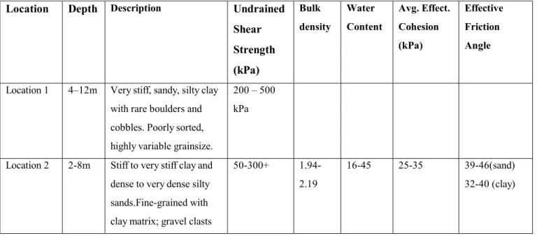
Table 3: Physical Properties of tills at Jeanne d’Arc Basin sites
Location Depth Description Undrained
Shear Strength (kPa) Bulk density Water Content Avg. Effect. Cohesion (kPa) Effective Friction Angle
Location 1 4–12m Very stiff, sandy, silty clay with rare boulders and cobbles. Poorly sorted, highly variable grainsize.
200 – 500 kPa
Location 2 2-8m Stiff to very stiff clay and dense to very dense silty sands.Fine-grained with clay matrix; gravel clasts
50-300+ 1.94-2.19
16-45 25-35 39-46(sand) 32-40 (clay)
The shallow water till (Location 1 and 2, Table 3), like the Avalon Channel example, may have a more complicated post-depositional history (repeated de-watering) than deeper water tills. The till on the outer
bank (Sackville Moraines area) is considered to be very dense and over-consolidated, based on our repeated inability to penetrate the surface with a large 1m3 clam-shell grab powered into the seabed. This contrasts with our experience on moraines in the Scotian shelf and Gulf of St. Lawrence and may be a n indication of higher sediment strength, consistent with the possibility of these being older tills.
2.2.6 Halibut Channel
Buried occurrences of the Grand Banks Till have been sampled in two geotechnical boreholes, 87B-2 and 87B-4, which intersected stacked multiple tills and Downing Silt well outside the map area on the
southern Grand Bank in Halibut Channel (Moran, 1987, Moran and Fader, 1997, Miller et. al., in press). Measured sediment properties are included here (Table 4) with some qualitative inferences as to the applicability to tills in the map area.
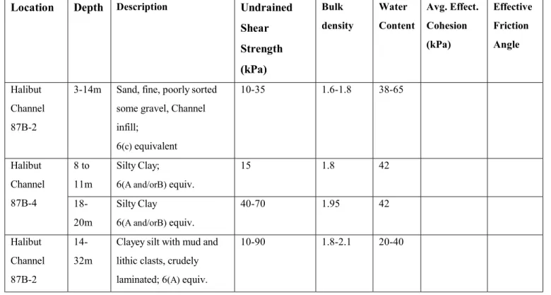
Table 4: Physical Properties of tills at Halibut Channel sites (southern Grand Banks)
Location Depth Description Undrained
Shear Strength (kPa) Bulk density Water Content Avg. Effect. Cohesion (kPa) Effective Friction Angle
3.5-9m “Upper till tongue” Stiff clay, massive, red; No map equivalent?
25-35 1.8-2.0 35-40 Halibut
Channel 87B-4
12-18m “Lower till tongue” Stiff clay, massive, with gravel; 4(up) equiv. but local distribution
20-65 1.65-2.15
35-52
32-38m “Red till”, massive silty clay possible 4(up) equiv.
20-90 1.85-2.0 30-41 38-48m “Grey till”
massive silty clay possible 4(up) equiv.
75-110 1.9-2.0 28-40 Halibut Channel 87B-2 48-75m “Basal till” probable 4(lw) equiv. 108-170 2.1-2.25 19-22
The shorter of the two Halibut Channel boreholes, 87B-4, intersects two till or till-like units (till tongues)
within the upper 20 m. The other borehole, 87B-2, samples three tills stratigraphically below (older) than tills in 87B-4. The “upper till tongue” (87B-4, Table 4) represents deposits from the latest ice cap
restricted to the outer bank and has no clear till equivalents in the map area of this study. The “lower till tongue” was likely deposited under similar conditions to till tongues in the map area. They have relatively high water content and low undrained shear strengths (20- 65 kPa). Both till tongues are considered normally consolidated. These till tongues are buried below the range of iceberg scour by Downing Silt but the sediment properties might be similar to the upper metres of the upper till, 4(up) in the map area. However, unlike the buried till tongue at the borehole site, most of the upper till in the map area has undergone post depositional lag gravel development from current action or intensive iceberg scouring soon after deposition. To what degree these affect strength properties, apart from developing a more gravely “crust”, is unknown.
The red and grey tills in 87B-2 (Table 4) are derived from a mainland based glacier. Likewise, the bulk of the upper till in the map area (Trinity Trough, Avalon Channel and eastward) is mainland derived and thought to be of similar age. Thus the sediment property values in these tills are most likely to be representative of the 4(up) tills. Shear strength measurements vary widely but are generally quite high (Table 4). A range of shear strengths from 75 to 110 kPa probably characterize the upper tills in the map area while their uppermost surface may be less competent, considering present conceptions of till
tongues, dilatent and “melt-out” or “flow” till with final retreat of the ice margin. The “basal till” in 87B-2 (Table 4) is from a glacial phase before the Late Wisconsinan maximum and its correlative in the map area is one of the lower tills (4(lw)). It is dense, with low water content, strength between 100 and nearly 200 kPa, and an overconsolidation ratio of 2.
2.3 Downing Silt
The Downing Silt Fm. consists of silty and clayey glacimarine sediments, typically confined to the basinal areas offshore of eastern Newfoundland. It is subdivided into several facies reflecting its varied
property differences among the silt-dominated facies (A and B) as among the sandier facies (C), so consider them as two sub-units here.
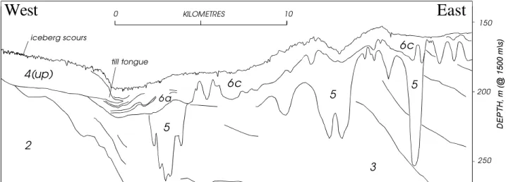
The silty facies of Downing Silt are generally rhythmically banded (cm scale) clayey-sandy silt with occasional gravel clasts, interpreted to have been deposited from suspension in front of a glacier margin from plumes and iceberg-rafted debris. It covers most of Trinity Trough as a blanket between five and 15 m thick but is thicker in the Bays of the Avalon Peninsula (Fig. 1). Here, icebergs scoured the Downing Silt during and after deposition and this action commonly destroyed the seismically stratified signature entirely (iceberg turbate, 6B(t)). This scouring is much diminished below a paleo-depth of about 320 m below present water depth such that the stratification is preserved.
Downing Silt thickness’ exceed 40 m in outer Trinity Bay while the inner bay has locally over 90 m along the central axis. It rarely exceeds 20 m thickness in the other bays. On the outermost shelf, just beyond the shelf break, Downing Silt thickens seaward to many metres; above ~ 500m it has been heavily scoured by large icebergs calved during past glaciation. Downing Basin, on the mid-shelf, has another extensive Downing Silt deposit.
The highly channeled part of the mid-shelf is dominated by Downing Silt deposits; the silty facies in the basins/channels (6A overlain by 6B) and the sandy time equivalents, 6C, on the flatter areas between basins (Fig. 7). Basinal fill is locally thick, typically over 20 m but not uncommonly over 50 m. These occurrences were sheltered from icebergs and their surfaces remain unscoured. The channels were the conduits for sub-glacial meltwater which eroded and infilled them and deposited a series of mounds in a broad, arcuate pattern near their termini. These mounds constitute what is informally here termed the Downing Moraine Complex (Fig. 1 and Fig. 4). These, and the broad apron of Downing Silt deposited beyond them, constitute the sandy facies (C) of the Downing Silt Fm. The morainic banks are complex but inferred to be mainly sandy. Locally they stand high enough to have been reworked by wave action during the lowstand and their upper surface constitutes clean sand, locally worked into small bedforms
that suggest continued reworking. The apron emanating from the mounds, 6C(oa) is locally thick (25 m) but thins toward greater water depth. It is sandy with gravel on its surface, near the morainic banks but internally may be more silty (local stratification). Its surface has preserved a highly iceberg scoured roughness which suggests a cohesiveness and strength closer to the silty facies of Downing Silt than sand
alone. At its northern edge it thins to blend with the till and a surficial gravel lag is evident. No physical property measurements are available.
Proximal (south) of the Downing Moraine, most of the seabed (between the channels/basins) has a thin (metres) cover of 6C (Figs. 1 and 7). This is a time equivalent of the basinal fill but exhibits a sandier seismic signature. It is overlain in turn by a veneer of Adolphus Sand, 7.
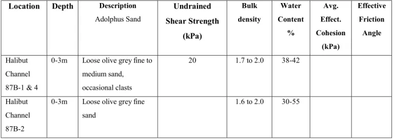
2.3.1 Engineering Properties of the Downing Silt
No physical measurements of the Downing Silt are available from the map area but there are equivalents in the Halibut Channel boreholes (Table 5). The near-seabed, fine sandy channel infill is analogous to the mid shelf highly channeled area. The other three samples should closely represent the siltier facies. Higher strengths at greater burial reflect normal consolidation. The lower of these values most likely corresponds to near-seabed exposures. Generally the basinal/silty facies of Downing Silt occurs below the present limit of iceberg scouring. No measurements are made on the presumably largely remolded Downing Silt
iceberg turbate, 6B(t).
Table 5: Physical Properties of Downing Silt (6) at Halibut Channel sites (southern Grand Banks)
Location Depth Description Undrained
Shear Strength (kPa) Bulk density Water Content Avg. Effect. Cohesion (kPa) Effective Friction Angle Halibut Channel 87B-2
3-14m Sand, fine, poorly sorted some gravel, Channel infill; 6(c) equivalent 10-35 1.6-1.8 38-65 8 to 11m Silty Clay; 6(A and/orB) equiv. 15 1.8 42 Halibut Channel 87B-4 18-20m Silty Clay 6(A and/orB) equiv. 40-70 1.95 42 Halibut Channel 87B-2 14-32m
Clayey silt with mud and lithic clasts, crudely laminated; 6(A) equiv.
2.4 Adolphus Sand
Adolphus Sand occurs at the seabed in the middle and outer shelf of the map area below approximately
105 and 110 m present-day water depth. It comprises variously compact to loose olive to olive grey fine or fine to medium sand, often with some silt and occasional shells and/or fine gravel, sometimes with lamination. It is interpreted as sublittoral deposits seaward of the limit of the late Wisconsinan low sea-level stand. It rarely exceeds two or three metres thickness but covers a large area of the map (Fig. 1). The cover of Adolphus Sand is generally thin at its shallow limit, thickens towards deeper water depths, and eventually gradually thins to only partially in-fill the relict iceberg scours cut into the top of the till, 4, or Downing Silt, 6C. The sidescan mosaic in Figure 10 shows the increasing continuity of sand cover to the NE as well as occasional gravel patches (till surface) protruding through the sand in deeper water. On the inner shelf the shallow limit of Adolphus Sand is mapped in shallower water depths reflecting our
current understanding of a shallower relative sea-level (John Shaw, GSCA, pers. comm.).
2.4.1 Engineering Properties of the Adolphus Sand
Geotechnical measurements are rare and only from outside the map area. The only shear strength measurement is approximately 20 kPa, from a Halibut Channel borehole (Table 6). Most geotechnical measurements were not taken in borehole 1 because of its overall sandy nature. It has been described as a fine to med sand with < 10% gravel and D50 of 0.22 mm. Fines content would be ~ from 0 - 5 %.
Table 6: Physical Properties of Adolphus Sand (7) at Halibut Channel sites (southern Grand Banks)
Location Depth Description
Adolphus Sand Undrained Shear Strength (kPa) Bulk density Water Content % Avg. Effect. Cohesion (kPa) Effective Friction Angle Halibut Channel 87B-1 & 4
0-3m Loose olive grey fine to medium sand, occasional clasts 20 1.7 to 2.0 38-42 Halibut Channel 87B-2
0-3m Loose olive grey fine sand
2.5 Grand Banks Sand and Gravel Formation
The youngest formation on outer Grand Bank is the Grand Banks Sand and Gravel Formation. The formation is in part relict (Grand Banks Gravel) and related to the late Wisconsinan-Holocene
transgression, but surficial sands and gravels (Grand Banks Sand) are presently undergoing reworking in water depths above approximately 100 m.
Grand Banks Gravel deposits are widespread, with rounded to sub-rounded lag gravels and boulders
that include lithologies derived from the Newfoundland mainland (Fader and Miller, 1986b). The gravels appear as a thin, fairly discontinuous cover in the regions above approximately 110 m where they were derived. In the Jeanne d’Arc Basin region, the gravel clasts consist of a variety of lithologies. Individual clasts range from 1 cm to as much as 10 or 20 cm in diameter and are generally angular to sub-rounded in shape. Isolated boulders are evident on the seabed. The gravel is interpreted as a basal transgressive deposit formed by reworking of glaciogenic sediments and bedrock during the low sea-level stand and the subsequent marine transgression. It is a thin lag deposit and is thought to be present across the entire
area, whether at the seabed, or in sub-crop beneath the surficial sands. Its thickness cannot be measured directly from the seismic data but is probably under one metre. Sand deposits, the Grand Banks Sand, represent the finer component of previously reworked material. The base of these sands is marked by the above noted gravel lag. The thickness of the sand is largely a function of where it has been reworked into large sand ridges. Where very thin (<1 m), its local distribution is commonly a function of smaller scale bedforms (extremely low relief flow transverse sand waves). The prominent sand ridges are the NE-SW oriented bodies of 8D (continuous sand) up to 9 m thick (Fig. 1). The gravel is typically exposed between sand ridges. Thinner sand ridges in the Hibernia-Hebron area are oriented more in an N-S sense. Storm conditions remobilize sand on the Grand Banks in the present day (Fader and Miller, 1986a; Fader et. al., 1985; Fader and Piper, 1990; King, 1989; Amos and King, 1984).
The Grand Banks Sand and Gravel Fm. is subdivided into 4 sub-units, 8A to 8D, plus an
undifferentiated designation largely reflecting the degree of sand versus gravel aerial extent and its ability to be mapped. Sub-unit 8A comprises the gravel lag. Unit 8B represents primarily gravel but with
the basal gravel lag. Sub-unit 8D comprises continuous sand, generally recognized from high resolution profiles as greater than 1 m in thickness. This sand is locally reworked at its surface into bedforms that
have further sorted some fine gravel and shell hash from the sand. While this can give a relatively high energy “gravel” acoustic signature on sidescan sonograms, it does not represent the coarser and thicker basal transgressive lag.
The boundaries shown on the map are necessarily approximations. A suite of figures, Fig. 10 to 15, is presented to depict the larger scale variability of sand and gravel at several sites. Figure locations are shown in Fig. 3. In these illustrations the Figure 1 zonation boundaries are superimposed in order to depict the degree of “averaging” or generalization. This suite of figures show either sidescan sonogram mosaics and/or a gravel-versus-sand interpretation based on the sidescan reflectivity signal strength. Figures 10 and 11 also show seabed photographs that further show the nature and variability of the sand and gravel distribution.
Iceberg scours in the Grand Banks Sand and Gravel represent the cumulative total since the onset of iceberg scouring 2500 years ago (Lewis and Parrott, 1987). However this total may be much diminished by scours which have since been reworked due to mobility of the sands. While sands are clearly mobile to some degree during large storms (Amos and Judge, 1991), the rate of scour degradation is unknown. There are greater numbers of scours recognized in the gravel but it is not clear if this is due to their more ready recognition on sidescan or their greater preservation potential in the less mobile sediments. Iceberg scours are much less numerous than in the relict scour network on the till surface (Fig. 9). Scours rarely exceed 1 m depth in the sands and gravels. These depths are clearly less than in the relict networks in the till, 4, and Downing Silt, 6c(oa), in deeper water, despite that sea-level was lower during glacial calving and peak scouring history of the latter. However, the iceberg draft population and wind/current regime were certainly different so scour depth differences are not readily related to differing sediment properties.
2.5.1 Engineering Properties of the Grand Banks Sand and Gravel
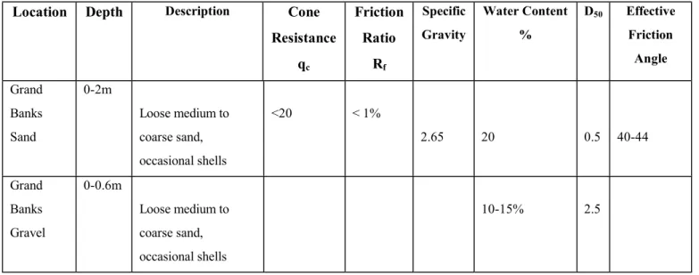
The Grand Banks Sand and Gravel is a clean, free-draining, well-sorted material ranging from uniform fine sand to gravel sized components. The large sand ridges on northeastern Grand Bank are comprised of clean, well-sorted medium to coarse-grained quartz sand with minor shell hash and gravel. D50 at the
Hibernia sand ridge site is 0.5 mm. Cone resistance (Qc) is typically < 15 Mpa. Friction ratio is < 1%.
Table 7 presents a summary of measurements from borehole studies (Mosher and Sonnichsen, 1992; Moran et. al. 1987; 1988). Representative measurements from the coarse Grand Banks Gravel are generally lacking due to sampling difficulties.
Table 7: Physical Properties of Grand Banks Sand & Gravel (8) at Jeanne d’Arc Basin sites
Location Depth Description Cone
Resistance qc Friction Ratio Rf Specific Gravity Water Content % D50 Effective Friction Angle Grand Banks Sand 0-2m Loose medium to coarse sand, occasional shells <20 < 1% 2.65 20 0.5 40-44 Grand Banks Gravel 0-0.6m Loose medium to coarse sand, occasional shells 10-15% 2.5 2.6 Placentia Clay
Placentia Clay, 9, is a soft, weakly stratified clay or silty clay ponded over Downing Silt 6B in basinal areas. Local occurrences at the base of small basins in the dissected part of the mid shelf are unmapped. Placentia Clay formed from suspension settling of the fines eroded from surrounding banks or
topographic highs and coastal areas, most active during early post-glacial marine sea-level rise. It is locally charged with gas. The surface is smooth with the exception of local cone-shaped pockmarks formed from resuspension and erosion with the periodic escape of gas from depth. There are no engineering properties measured on the clay in the map area. Its basinal setting precluded scouring by icebergs in early post-glacial times as it does for the modern iceberg population.
2.7 Iceberg scour and sediment type relationships
Iceberg scour and pit databases (Campbell, 2001) exist for the Grand Banks region, focusing on the post-glacial scours. This, combined with the regional sediment type distribution provides the possibility for future studies related to the modern scouring regime, and the study of the scour/sediment relationships. A GIS-based approach will be addressed. Clearly any relationships are complicated by water depth,
temporal variability in sea-level, glacial ice cover, and iceberg population and these factors also strongly influence sediment type and preservation. Thus, a straightforward comparison of scour characteristics and sediment type would be too simplistic.
The geologic record provides the ultimate field experiment regarding sediment/ice impact because it records countless actual events. However, extrapolation to the modern current-sediment-iceberg context requires an understanding of the context under which the scouring occurred. One of the challenges is a more routine or reliable dating method for scours. Another is the better understanding of the glacier flow and retreat pattern and paleo-geography.
For example, iceberg scour characteristics vary considerably in till of the northern Avalon Channel in comparison to scours in nearly identical water depths immediately to the east, in the area of sandy Downing Silt 6C seabed cover (Fig. 1). Scours are considerably fewer, shallower, less continuous, and recognized pits are fewer in the sandy unit. Part of the difference may be a different initial sediment competency or a greater preservation potential in the more cohesive till sediment (less immediate or enhanced mobility “healing”). However, despite the proximity of the two sites, a scenario can be
constructed whereby the iceberg population and behavior may have been different. The Avalon Channel area, under glacial retreat, is thought to have undergone relatively rapid, perhaps catastrophic, calving from a floating or near floating ice terminus, causing a “reentrant” of the ice margin to well south of the peninsula (Josenhans et. al. in prep.). This would have isolated Avalon Peninsula-based ice from central Grand Bank-based ice and created abundant icebergs which thoroughly scoured the newly exposed till
surface. Meanwhile, to the east, continued ice cover protected it from these icebergs. The Grand Bank based ice cap evolved into an ablation mode whereby meltwater was an important component while the ice margin remained temporarily stationary while forming the Downing Moraine complex. Iceberg
to the south, calving would resume but presumably from thinner and less voluminous glacier and with more meltwater presence. The meltwater abundance caused the sandy surficial cover of 6C. Resulting
iceberg scour population would be different.
Another approach relating ice impact to sediment type is through modeling, using the appropriate ice and soil properties; this report is an attempt to demonstrate the range and variability of these soil properties for this purpose.
3.0 CONCLUSIONS
A regional characterization of seabed sediments at a practical scale and a summary of their engineering properties are attempted. A new surficial geology zonation compilation is presented together with a brief geological setting, description, and geologic unit distribution. Existing geotechnical measurements for the surficial sediments are sparse and many are extrapolated from outside the map area but grain size,
density, water content and strength values are presented for most. Values vary widely, reflecting the variable nature of the sediment and its depositional processes and post-depositional history. Two types of
hard bedrock are exposed very locally, mainly in the shallowest, nearshore areas. Most of the seabed comprises an extensive blanket cover of relatively hard till (sub-glacially deposited clay to boulder range), the Grand Banks Till Formation. This originated from glacial ice cover, likely in more than one phase, the latest lasting from about 25,000 to 14,000 years before present. This deposited locally in long morainic ridges and its upper surface was modified by relict icebergs and current action, creating an undulatory (1 to 3m relief) gravely or sandy gravel seabed. Reported shear strengths are as low as 20 kPa for young, unmodified deposits and as high as 515 kPa for old, glacially overridden and desiccated samples, but most seabed exposures probably range from 75 to 110 kPa. In deep water areas (generally over 300 m) and in numerous but small, isolated basins, suspension-deposited glaciogenic silt-dominated deposits, Downing Silt Fm., overly the till in blankets from a few to ten’s of metres thick. This was deposited largely beyond the ice margin during retreat phases. Strength measurements from 10 to 35 kPa probably characterize the near-surface. Some have been extensively iceberg scoured but this is mainly from times of lower sea-level and abundant glacier calving and the modern iceberg regime is unlikely to impact these silts. The same holds for overlying clay dominated muds, the Placentia Clay Fm. A sandier sub-unit of the Downing Silt
occurs in water depths more likely to be scoured. Measurements are largely lacking but relict scours are similar to that in the till at its deeper extents. The shallower extents are probably sandier and preserve
fewer, shorter, and shallower scours. Both the Grand Banks Till and Downing Silt Formations are covered with a veneer of silty sand, Adolphus Sand, over an extensive area between about 100 to 150 m water depth, deposited as near-shore sands below the former low stand of sea-level. This sand reaches up to several metres thickness but generally is thin enough that icebergs can potentially penetrate to the underlying substrate. The Adolphus Sand has only one reported shear strength of 20 kPa. Above about 105 to 110 m water depths are extensive washed sands and gravels of the Grand Banks Sand and Gravel Fm. They have been subjected to coastal and shallow water processes as sea-level rose during the last 15,000 years. The rounded gravel locally overlies patchy till deposits from which it derived through the coastal zone reworking. However, generally all till remnants have been removed and the gravel lies on much older and partially consolidated or cemented marine sands and silts. Its thickness is not well documented but likely varies from several cm to 1 or 2 m. The gravel is overlain by medium and coarse sands of highly variable thickness (up to 10 m) and distribution. The surficial map and accompanying illustrations attempt to characterize this variability, where data control is available. Engineering properties vary greatly, reflecting local heterogenieties. These cohesionless soils are variously characterized by cone resistance that is typically < 15 Mpa. Iceberg scours accumulated since the rise of sea-level are best imaged acoustically and/or preserved in the gravely zones. The new geological zonation provides a basis for future correlation of an extensive database of iceberg scour features measured on the seabed with sediment type.
4.0 REFERENCES
Amos, C.L. and Judge, J.T., 1991. Sediment transport on the eastern Canadian continental margin. Continental Shelf Research, 11, 8-10, 1037-1068.
Amos, C.L. and King, E.L., 1984. Bedforms of the Canadian eastern seaboard; a comparison with global occurrences. Marine Geology, 57, 167-208.
Barrie, J.V., Lewis, C.F.M., Fader, G.B.J. and King ,L.H. 1984. Seabed processes on the northeastern Grand Banks of Newfoundland; Modern reworking of relict sediments. Marine Geology, 57, 209-227.
Campbell, P., 2001. Grand banks iceberg Scour Catalogue; 2001 Modifications and Additions. Database and report (in draft).
Fader, G.B. and King, L.H. , 1981. A reconnaissance study of the surficial study of the surficial geology of the Grand Banks of Newfoundland. In Current Research, Part A, Geological Survey of Canada, Paper 81-1A, 45-56.
Fader, G.B.J. and Miller, R.O. 1986a. A reconnaissance of the surficial and shallow bedrock geology of the southeastern Grand Banks of Newfoundland. In Current Research, Part B, Geological Survey or Canada, Paper 86-1B, 591-604
Fader, G.B.J. and Miller, R.O., 1986b. Regional geological constraints to resource development - Grand Banks of Newfoundland. 3rd Canadian Conference on Marine Geotechnical Engineering, St. John's Newfoundland, June 1986, Proceedings 1, 3-40.
Fader, G.B.J., Lewis, C.F.M., Barrie, J.V., Parrott, D.R., Collins, W., Miller, R.O., and d’Apollonia, 1985. Quaternary geology of the Hibernia area of northeast Grand Bank. Geological Survey of Canada, Open File 1222.
Fader, G.B. and Piper, D.J.W., 1990. The Southeast Canadian Region. In Piper, D.J.W., Mudie, O.J., Fader, G.B., Josenhans, H.W., MacLean, B., and Vilks, G. (Eds.) Quaternary Geology, Chapter 10, Geology of the Continental Margin of Eastern Canada, M.J. Keen and G.L. Williams, (eds.), Geological Survey of Canada, Geology of Canada, No. 2, 475-607 pp. (also Geological Society of America,
Geology of North America, v. I-1).
Grant, A.C., McAlpine, K.D., and Wade, J.A., 1986. The continental margin of Eastern Canada:
geological framework and petroleum potential. In M.T. Halbouty (ed.) Future Petroleum Provinces of the World. American Association of Petroleum Geologists, Memoir 40, 177-205.
Josenhans, H., Shaw, J. et al. (in prep.) Late Wisconsinan glacier margin reconstruction offshore the Atlantic Provinces. (unofficial title) Geological Survey of Canada report in progress.
King, E.L. 1989. Quaternary Geology of the Hibernia Area of northeast Grand Bank. Unpublished report by Edward L. King & Associates to Geological Survey of Canada, Atlantic Geoscience Centre, BIO, Dartmouth, N.S. 29p. plus appendices and enclosures.
King, E.L. and Fader, G.B. 1992. Quaternary geology of southern Northeast Newfoundland Shelf. Abstract, Geological Association of Canada-Mineralogical Association of Canada Joint Annual Meeting, May 25-27, Wolfville, Nova Scotia.
King, E.L., and Sonnichsen, G.V. 1999. Characterization of near-surface seismostratigraphy and features of northeastern Grand Bank: sea-level fluctuations, glaciation and slope stability. Geological Survey of Canada Open File D3886, 78 p. plus enclosures
King, E.L. and Sonnichsen G.V., 2000 New Insights into glaciation and sea-level fluctuation on northern Grand Bank, offshore Newfoundland. In Current Research, Geological Survey of Canada, Paper 2000-D6, 1-10.
King, L.H. and Fader, G.B., 1986. Wisconsinan glaciation of the Atlantic continental shelf of southeast Canada. Geological Survey of Canada, Bulletin 363, 72p.
King, L. H., Fader, G.B.J., Jenkins, W.A.M., & King, E.L. 1986. Occurrence and regional geological setting of Paleozoic rocks on the Grand Banks of Newfoundland. Canadian Journal of Earth Sciences, 23, 504-526.
Lewis, C.F.M., and Parrott, D.R., 19887. Iceberg scouring rate studies, Grand Banks of Newfoundland; in Current Research, Part A, Geological Survey of Canada. Paper 87-1A, p. 825-833, 1987.
Lewis, C.F.M., Parrott, D.R., and Durling, P.W., 1987. Shallow Tertiary Seismostratigraphy and engineering geology of the Northeastern Grand Banks of Newfoundland. Geological Survey of Canada, Open File 1437, 22p.
Long, L.C., Thompson, G.R., Brown, J.D., and Rivette, C.A. 1986. Hibernia site geotechnical
characterization. In Proceedings of the Third Canadian Conference on Marine Geotechnical Engineering, St. Johns, Newfoundland, June 1986, 99-116.
Miller, A.A.L., Fader, G.B.J. and Moran, K. in press. Late Wisconsinan ice advances, ice extent, and glacial regimes interpreted from seismic data, sediment physical properties, and Foraminifera: Halibut Channel, Grand Banks of Newfoundland. In: Weddle, T.K. & Retelle, M.J. (Eds.), Deglacial History and Relative Sea-Level Changes. Northern New England and Adjacent Canada. Boulder, Colorado,
Geological Society of America, Special Paper 351, 51-78 plus appendix.
Moran, K., 1987, Cruise Report 87400, M/B Balder Challenger: Dartmouth, Canada, Geological Survey of Canada, Atlantic Geoscience Center, Bedford Institute of Oceanography, 26 p.
Moran, K and Fader, G.B.J., 1997, Glacial and Glaciomarine Sedimentation: Halibut Channel, Grand Banks of Newfoundland. In: Davies, T.A., Bell, T., Cooper, A.K., Josenhans, H., Polyak, L., Solheim, A., Stoker, M.S., & Stravers, J.A. (Eds.) Glaciated Continental Margins: An Atlas of Acoustic Images. Chapman & Hall, London, 217-220.
Moran, K., Mosher, D.C., Gillespie, D., Jarrett, K., and Courtney, R.C. 1988. Cruise report M/V Pholas 88401. Geological Survey of Canada Open File 2297, 63 p.
Mosher, D.C. and Sonnichsen, G.V., 1992. Stratigraphy and sedimentology of sediments on the
northeastern Grand Banks of Newfoundland from borehole investigation. Geological Survey of Canada, Open File 2409, 91p.
Newfoundland Geosciences Ltd., 1984. Geotechnical investigation, pipeline route south of Virgin Rocks, Hibernia development. Report to Mobil Oil Canada, Ltd., 26 p. plus appendices.
Piper, D.J.W., and Pereira, C.P.G., 1992. Late Quaternary sedimentation in central Flemish Pass, Canadian Journal of Earth Sciences, 29, 535-550.
Segall, M.P., Buckley, D.E. and Lewis, C.F.M. 1987. Clay mineral indicators of geological and
geochemical subaerial modification of near surface Tertiary sediments on the northeastern Grand Banks of Newfoundland. Canadian Journal of Earth Sciences, 24, 2172-2187.
Sonnichsen, G.V., and Cumming, E., 1996. Shallow stratigraphy, sediment properties, and foundation stability in the Jeanne d’Arc Basin discovery area. 49th Canadian Geotechnical Conference, Proceedings Volume I, 181-188.
Sonnichsen, G.V., and Zevenhuizen, J. 1996. Seabed characterization and soil response at the Terra Nova O-90 glory hole: observed changes, 1990-95. Geological Survey of Canada Open File 3681, 80 p.
Sonnichsen, G.V., Moran, K., Lewis, C.F.M., and Fader, G.B., 1994. Regional seabed geology and engineering considerations for Hibernia and surrounding areas. Energy Exploration and Exploitation, 12, no. 4, 325-345.
Terraquest Associates, 1995. Structural contour maps of the shallow seismostratigraphy, Northeast Grand Bank, Newfoundland. Contract report submitted to the Atlantic Geoscience Centre, Geological Survey of Canada. Open File 3128.
5.0 SURFICIAL GEOLOGY MAP REFERENCES
Barrie, J.V., Lewis, C.F.M., Fader, G.B.J. and King ,L.H. 1984. Seabed processes on the northeastern Grand Banks of Newfoundland; Modern reworking of relict sediments. Marine Geology, 57, 209-227.
Fader, G.B. and King, L.H., 1981. A reconnaissance study of the surficial study of the surficial geology of the Grand Banks of Newfoundland. In Current Research, Part A, Geological Survey of Canada, Paper 81-1A, 45-56.
Fader, G.B.J. and Miller, R.O., 1986. A reconnaissance of the surficial and shallow bedrock geology of the southeastern Grand Banks of Newfoundland. In. Current Research, Part B, Geological Survey or Canada, Paper 86-1B, 591-604.
Geomarine Associates Ltd. 1993. Surficial Geology of the Central Grand Banks of Newfoundland, Halibut Channel to Whale Bank. Geological Survey of Canada. Open File No. 2088. 488 p. plus enclosures.
King, E.L. 1989. Quaternary Geology of the Hibernia Area of northeast Grand Bank. Unpublished report by Edward L. King & Associates to Geological Survey of Canada, Atlantic Geoscience Centre, BIO, Dartmouth, N.S. 29p. plus appendices and enclosures.
King, E.L. and Fader, G.B. 1992. Quaternary geology of southern Northeast Newfoundland Shelf. Abstract, Geological Association of Canada-Mineralogical Association of Canada Joint Annual Meeting, May 25-27, Wolfville, Nova Scotia.
King, E.L. and Fader, G.B. in prep. Quaternary Geology of the Northeast Newfoundland Shelf: Contrasts in Late Wisconsinan glacial regimes.
King, E.L. and Sonnichsen G.V., 2000 New Insights into glaciation and sea-level fluctuation on northern Grand Bank, offshore Newfoundland. In: Current Research, Geological Survey of Canada, Paper 2000-D6, 1-10.
King, L.H. and Fader, 1981. Seabed conditions east of the Avalon Peninsula to the Virgin Rocks - their relationship to the feasibility of a pipeline from the Hibernia P-15 wellsite area to Newfoundland.
Geological Survey of Canada, Open File 723, 5p.
McGregor Geoscience Ltd., 1998. East Flying Foam (1996) seafloor ice scour analysis. Contract Report to the Geological Survey of Canada (Atlantic)20 pages plus databases
Sonnichsen, G.V., Moran, K., Lewis, C.F.M. and Fader, G.B.J., 1994. Regional seabed geology and engineering considerations for Hibernia and surrounding areas. Energy Exploration and Exploitation, 12, 4, 325-345.
Sonnichsen, G.V., 1999. Establishment of the 024 baseline iceberg scour survey: CCGS Matthew 98-024. Geological Survey of Canada Open File Report #D3821 (CD-ROM).
Synmap Information Technologies, 1996. 4000 Series Repetitive Seafloor mapping, 1994. Contract Report to the Geological Survey of Canada (Atlantic) 27 pages pluas appendices and databases.
Staal, P. and Fader, G.B.J. 1987. Sediment Thickness Study of the Eastern Canadian Continental Shelf Geological Survey of Canada. Open File 1427. 25 p. plus 13 enclosures.
Zevenhuizen, J. 1997. Surficial geology and surficial features of northeastern Grand Banks: Hibernia – Terra Nova Oilfields area. Unpublished report by Seabed Exploration Associates (1997) to Geological Survey of Canada, Atlantic Geoscience Centre, BIO, Dartmouth, N.S. ?? p. Plus appendices and enclosures.