HAL Id: hal-01278938
https://hal.archives-ouvertes.fr/hal-01278938
Submitted on 30 Mar 2016
HAL is a multi-disciplinary open access
archive for the deposit and dissemination of
sci-entific research documents, whether they are
pub-lished or not. The documents may come from
teaching and research institutions in France or
abroad, or from public or private research centers.
L’archive ouverte pluridisciplinaire HAL, est
destinée au dépôt et à la diffusion de documents
scientifiques de niveau recherche, publiés ou non,
émanant des établissements d’enseignement et de
recherche français ou étrangers, des laboratoires
publics ou privés.
On the contribution of dendrometric “ rules ” to
improve accuracy and genericity of ALS models using an
area-based approach
L. Saint André, J. P. Renaud, C. Véga, J. Bock, S. Durrieu, M. Bouvier
To cite this version:
L. Saint André, J. P. Renaud, C. Véga, J. Bock, S. Durrieu, et al.. On the contribution of dendrometric
“ rules ” to improve accuracy and genericity of ALS models using an area-based approach. SilviLaser
2015, Sep 2015, La Grande Motte, France. pp.125-127. �hal-01278938�
On the contribution of dendrometric « rules » to improve accuracy and genericity of
ALS models using an area-based approach
L. Saint-André1,2, J.P. Renaud3, C.Véga4, J. Bock5, S. Durrieu6, M. Bouvier6 1: INRA, Biogéochimie des Ecosystèmes Forestiers, Rue d'Amance, F-54280 Champenoux
(st-andre@nancy.inra.fr)
2: CIRAD, UMR ECO&SOLS, F-34000 Montpellier
3: Office National des Forêts, Département RDI, 11 rue Ile de Corse, F-5400 Nancy. 4: IGN, Laboratoire de l’Inventaire Forestier, 11 rue Ile de Corse, F-54000 Nancy 5: Office National des Forêts, Département RDI, 42 quai Charles Roissard, F-73023 Chambéry
6: IRSTEA, Maison de la télédétection, F-34000 Montpellier
Highlights: An approach integrating forest allometric relationships into Lidar models is proposed in a
consistent and comprehensive way. This approach, generic and reliable, fits a large diversity of stands
and flight conditions (e.g. coniferous/broadleaves; mountain/lowland stands), and use only a limited
number of Lidar metrics.
Key words: Forest allometric relationships, relative density index, forest basal area
Introduction
Lidar remote sensing is a state of the art technology for characterizing forest structure and estimating forest attributes, e.g. dominant height, basal area, volume and aboveground biomass. For the last decade, two main approaches have been developed to predict them from Lidar point clouds. The most prevalent one consists in developing models based on Lidar metrics computed at the plot level. This area-based approach is considered to perform well in various acquisition conditions and has already been integrated into operational forest inventory procedures [e.g. 3]. However, it is based on empirical models that require field calibration for each Lidar survey [3]. Furthermore, field calibration plots has to be in synchronicity with the Lidar acquisitions in order to avoid bias associated with growth and silvicultural practices (e.g. thinning) between field and Lidar campaigns.
The alternative approach is based on individual tree segmentation and characterisation. This strategy provides measurements of tree attributes that are similar to field measurements and could benefit from some established allometries between tree height, crown area or diameters at breast height to refine segmentation. However, such tree segmentation required high point cloud densities (> 5 points/m²) and is computationally demanding. Moreover, its implementation over large areas remains challenging due to computational cost and to the calibration needs to minimize omission and commission errors for a wide range of forest types.
Recent developments have shown that it is possible to improve the area-based approach by using Lidar metrics that match closely different aspects of stand structures. For example, Bouvier et al. [1] showed that the use of such metrics improves model genericity, but does not alleviate the need to calibrate models for every Lidar acquisition. In this study, we hypothesize that integrating into area-based approach, constraints arising from allometric rules, well known and widely used by foresters, could further improve model genericity. We developed a model based on height-diameter relationships, and on Reineke’s rule of self-thinning [2]. We tested this approach on a large diversity of stands and Lidar acquisition conditions, in order to estimate its robustness.
Material and methods
Proposed methodology
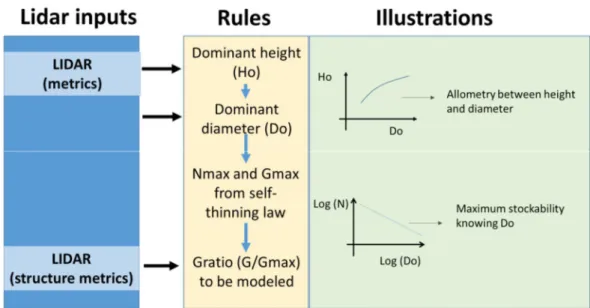
Figure 1 presents the flowchart of the proposed methodology that follows several steps to predict plot basal area (G). First, dominant height (Ho) is estimated at the plot level from Lidar metrics. Inverting standard height – diameter curves yield plot dominant tree diameter (Do) for each plot, which is further refined by using additional Lidar metrics to get unbiased estimates of Do among all stands. Then the maximum stockability in terms of stem density (N) and basal area (Gmax) for a given Do, is assessed based on self-thinning equations based on the
Reineke’s relative density index [2, 4, 5]. Next, a model of G ratio (assessing the deviation of the actual G from the maximal possible G value of the plot) is established. At this step, “structural” Lidar metrics are integrated into the model (e.g. canopy cover). Finally, back transforming the resulting model yield an estimate of G that only uses a few Lidar metrics.
Figure 1. Flowchart of the modelling approach followed, showing the inputs points of the Lidar metrics and the allometric rules used to obtain the final basal area (G) estimations.
Lidar acquisitions over eight coniferous and broadleaves stands were used in this study, covering a large range of Lidar densities (from 2 points/m² to 30 points/m²), topographical conditions (lowland and mountain locations), and both stand structures and composition (i.e. regular and irregular stands; monospecific and mixed stands). One broadleaves stand was also flown at 2 vegetation periods (i.e. leaf-on and leaf-off). Over 500 plots were used to estimate G using the proposed approach.
Results and discussion
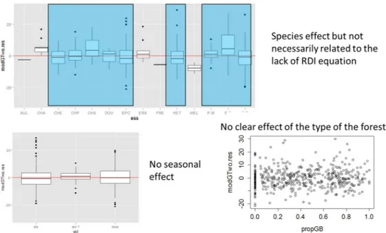
Over all stands examined in this study, the relative residual error (rRMSE) remained under 10% for the prediction of G. The resulting model appeared to be mostly unbiased (Figure 2), suggesting that this approach is robust to a large range of stand and both environmental and Lidar flight conditions. Examination of the residuals showed only a limited number of bias conditions associated to a few species. Globally the proposed model appeared unbiased and robust, providing accurate G estimations and showing neither seasonal, nor stand structure effects (Figure 2).
Figure 2. Model residuals as affected by tree species (top), season (bottom left), or forest types (bottom right).
Conclusion
The proposed approach integrates the knowledge developed in forest growth allometry into Lidar models in a consistent and comprehensive way. The work is still ongoing to further improved results and to provide volume, biomass, and stem density estimations along with G estimations.
References
[1] Bouvier, M., S. Durrieu, R.A. Fournier and J.-P. Renaud. 2015. Generalizing predictive models of forest inventory attributes using an area-based approach with airborne LiDAR data. Remote Sensing of Environment 156: 322‑34.
[2] Charru, M., I. Seynave, F. Morneau, M. Rivoire and J.-D. Bontemps. 2012. Significant Differences and Curvilinearity in the Self-Thinning Relationships of 11 Temperate Tree Species Assessed from Forest Inventory Data. Annals of Forest Science 69 (2): 195‑205.
[3] Næsset, E., T. Gobakken, J. Holmgren, H. Hyyppä, J. Hyyppä, M. Maltamo, M. Nilsson, H. Olsson, A. Persson and U. Söderman. 2004. Laser scanning of forest resources: the nordic experience. Scandinavian Journal of Forest Research 19 (6): 482‑99.
[4] Pretzsch, H. 2006. Species-Specific Allometric Scaling under Self-Thinning: Evidence from Long-Term Plots in Forest Stands. Oecologia 146 (4): 572‑83.
[5] Pretzsch, H. and T. Mette. 2008. Linking Stand-Level Self-Thinning Allometry to the Tree-Level Leaf Biomass Allometry. Trees 22 (5): 611‑22.