HAL Id: hal-01518639
https://hal-brgm.archives-ouvertes.fr/hal-01518639
Submitted on 5 May 2017HAL is a multi-disciplinary open access archive for the deposit and dissemination of sci-entific research documents, whether they are pub-lished or not. The documents may come from teaching and research institutions in France or abroad, or from public or private research centers.
L’archive ouverte pluridisciplinaire HAL, est destinée au dépôt et à la diffusion de documents scientifiques de niveau recherche, publiés ou non, émanant des établissements d’enseignement et de recherche français ou étrangers, des laboratoires publics ou privés.
Airborne and land-based controlled-source
electromagnetic surveying in challenging
electromagnetic environments – application to
geothermal exploration in a volcanic island
Mathieu Darnet, Nicolas Coppo, Pierre-Alexandre Reninger, Pierre
Wawrzyniak, Jean-François Girard, Bernard Bourgeois
To cite this version:
Mathieu Darnet, Nicolas Coppo, Pierre-Alexandre Reninger, Pierre Wawrzyniak, Jean-François Gi-rard, et al.. Airborne and land-based controlled-source electromagnetic surveying in challenging elec-tromagnetic environments – application to geothermal exploration in a volcanic island. 79th EAGE Conference & Exhibition 2017, Jun 2017, Paris, France. �hal-01518639�
Airborne and land-based controlled-source electromagnetic surveying in challenging
electromagnetic environments – application to geothermal exploration in a volcanic island Mathieu Darnet (1), Nicolas Coppo(1), Pierre Alexandre Reninger(1), Pierre Wawrzyniak(1), Jean-François Girard(2) and Bernard Bourgeois(1)
(1)
BRGM, France
(2)
Formerly at BRGM, now at EOST, France Summary
Exploring for underground resources using land-based electromagnetic methods can be very challenging due to the presence of strong human-generated and “geological” noise. In such context, some passive EM techniques like the Magneto-Telluric method may not be applicable at all and a dedicated toolbox of EM techniques capable of dealing with these issues is required. We focus here on the challenges encountered while exploring for geothermal resources in volcanic islands, namely a highly heterogeneous near-surface creating strong static-shifts, the presence of a sea/land transition zone and a high degree of urbanization over the area of interest. We will show that a combined airborne and land-based controlled-source EM approach provide a robust approach and illustrate these aspects with an EM dataset acquired over the Martinique Island, in the French Lesser Antilles. We believe this work sets the foundations for more robust geophysical exploration workflows in such challenging EM environments.
Introduction
Land-based electromagnetic (EM) methods, attempting to detect contrasts in electrical resistivity between target resources and their surroundings, have been developed and utilized for exploring buried resources such as minerals, hydrocarbons, geothermal energy, or groundwater for more than a century (Streich, 2016 and reference therein). Dealing with noise has complicated EM recordings ever since the first EM measurements were made. Various types of noise have been recognized as, for instance, human-generated noise (e.g. power grid, railways, industrial facilities). Magnetotelluric signal can be regarded as noise in the context of active EM surveying. Finally, subsurface heterogeneity like bodies at depth, small-scale structure near the sources or receivers not resolvable by the measurement technique used, can mask target responses and hence be considered as “geological noise”.
In order to explore for underground resources in a large variety types of environments (e.g. urbanized areas, mountainous terrains, volcanic areas, sedimentary basins), we have developed a comprehensive toolbox of EM techniques capable of dealing with such challenging EM environments. In this paper, we will focus on the challenges encountered while exploring for geothermal resources in volcanic islands, namely a highly heterogeneous near-surface, the presence of seawater and a high urbanization over the areas of interest. We will show that combined airborne and land-based controlled-source EM methods provide a robust approach and illustrate these aspects with an EM dataset acquired over the Martinique Island, in the French Lesser Antilles.
EM challenges in a volcanic island – Example of the Lamentin Bay area
The study area is the Lamentin bay area located near Fort de France, the main city of the Martinique Island (Lesser Antilles, France, see figure 1). This area is an alluvial plain lying over a volcanic substratum with a strong hydrothermal activity as evidenced by numerous hot springs. Exploratory drilling since the 1980’s highlighted a polyphased hydrothermal system with fossilized hydrothermal features and a recent hydrothermal activity. In terms of hydrogeology, the area is characterized by a superficial free aquifer in the sediments subject to seawater infiltration. As a result, the geothermal system is poorly understood and has prevented any exploitation of the geothermal resource to date. In an attempt to reduce the geological risk for future geothermal development, BRGM was mandated to conduct a geophysical survey over the area. It however exhibits all the typical challenges that can face geophysical methods in such volcanic islands. First, the near-surface is a highly heterogeneous system with a mix of altered and unaltered lavas alternating with volcano-detritic sediments. Secondly, the area is entirely urbanized and therefore the use of Magneto-Telluric soundings for deep EM imaging is not possible. Finally, the geothermal field is likely to extend underneath the bay area and the acquisition of offshore data is necessary. In order to tackle these issues, our strategy was to acquire high density airborne EM data to characterize the shallow layers and combined them with onshore/offshore CSEM data for deeper imaging.
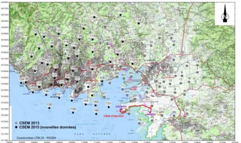
Figure 1: Location of the CSEM recording stations (black dots) and CSEM transmitter (thick red line) acquired of the prospective area of the Lamentin Bay area, next to the Fort de
France city. The
geothermal field is likely to sit underneath the bay area where several exploratory wells have been drilled (red circles).
Airborne EM survey results
A heliborne EM survey covering the whole Martinique has been carried out using the SkyTEM system, which operates in a dual transmitter mode. The survey was flown primarily in the N-S direction with a 400 m framework, locally reduced to 200 to 100 m spacing. The spacing between each EM sounding along the flight lines is approximately 30 m. The nominal height of the loop was on average about 64 m above ground level, due to the variable topography of the island.
Because of the presence of many urbanized areas and strong power lines that drastically deteriorate EM responses, the area of interest was only partially covered and particular attention was paid to properly remove noise from the data at the processing stage. The airborne EM soundings are available every 10m along flight lines. Data were then inverted using the Spatially Constrained Inversion (Viezzoli et al., 2008). Each EM sounding was inverted to obtain a 1-D earth model constrained vertically and laterally by nearby soundings.
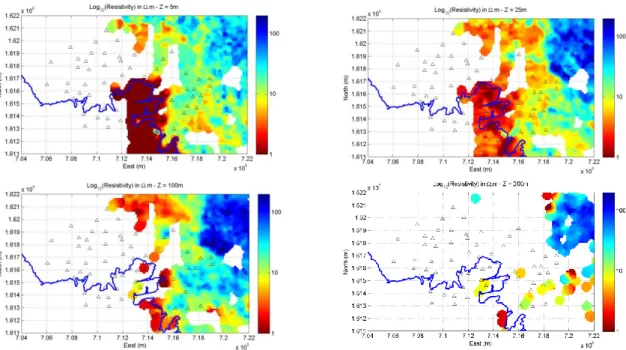
Figure 2 shows resistivity maps recovered at 5m, 25m, 100m and 200m depth over the area of interest. It clearly delineates a shallow conductive anomaly (< 1 Ω.m, <25m) around the bay area representative of the seawater intrusion zone. On the other hand, the eastern part of the survey is highly resistive at all depth (>100 Ω.m) highlighting the presence of thick andesitic lavas.
Figure 2: Resistivity maps recovered at 25m, 100m, 250m and 1000m depth from the 1D modelling/inversion of the airborne EM and CSEM datasets. Black triangles represent the CSEM recording stations.
Land/shallow marine CSEM survey results a) CSEM data acquisition and processing
The CSEM survey was acquired using a double LEMAM injection setup for the transmitter (LEMAM standing for Long Electrode Mise-à-la Masse). It uses the metallic casings of boreholes as long electrodes for current injection. Here, two deep exploratory boreholes (~400m) connected with a 4km long electric cable were used. Due to the good electrical coupling of the casings with the earth, the current injected was about 30A. To adequately characterize the subsurface, a broad band of CSEM frequencies (fundamental frequencies from 0.125 Hz up to 512 Hz increasing with a factor 4) was acquired with a minimum of 150 cycles at low-frequencies to ensure proper stacking of any random
number of 100 CSEM recording stations were deployed on the Lamentin bay area (figure 1), 80
onshore and 20 offshore. They were Metronix ADU06 or ADU07 acquisition systems, MFS07 or MFS06 magnetic coils and 2 orthogonal electric dipoles from 20 to 100m long.
Raw data have been processed in the frequency domain using a proprietary code. After automatic and manual quality control of the processed data, 20% of the data was rejected due to high levels of noise, mainly due to the weak CSEM signal at stations at large distances from the transmitter (> 6km). The remaining 80% of the data were considered of good quality and subsequently inverted. In total, 42 frequencies (= fundamental frequencies + frequencies up to the 13th harmonics x 7 transmitter frequencies) have been processed to provide a broadband signal and allow an easy removal of noisy frequencies bands (e.g. industrial noise at 50Hz and harmonics). At this stage, we only worked with the amplitude and phase of the maximum axis of the polarization ellipses of the horizontal electric field as their spectra are a lot smoother and hence easier to quality control than individual horizontal components (which can sometimes cross zero and hence be confused with noise). It surely comes at the expense of losing some information, especially the “3D effects”, but we consider these as second order effects that will be studied at a later stage.
b) CSEM static-shift corrections
As evidenced by the airborne EM data (figure 2), the near-surface (<100m) can be very heterogeneous and its electrical resistivity can increase from a few Ω.m up to a few 10’s of Ω.m in a very short distance (<500m), especially in the eastern side of the survey area where resistive silicified sediments can be found amongst conductive seawater filled sediments. Such a short contrast of resistivity will give rise to a static-shift effect on the CSEM measurements (MacLennan and Li, 2013), similar to what can be observed on MT data.
To correct for this effect, we have used the results from the airborne EM survey as inductive methods do not suffer from such effects (Sternberg, 1988). The CSEM static shift correction is calculated by fitting the high frequency amplitude response to the modelled response computed on the resistivity model obtained from the inversion of the airborne EM data, typically for frequencies greater than 100Hz. For CSEM stations located on the eastern side of the survey area and where shallow layers are rather heterogeneous (figure 2), significant static shift corrections are required. However, on the western part of the survey, shallow sediments are rather conductive and homogeneous and CSEM data do not require significant static-shift corrections.
c) 1D CSEM/AEM modelling/inversion results
Once data have been processed and static-shift corrected, we inverted them by determining the resistivity of a multi-layered earth model for each CSEM station. During this process, we fixed the resistivity of the shallow layers with the resistivity obtained from the inversion of the airborne EM data. When not available, we used the high frequency CSEM dataset to estimate it. Fortunately, such points are located in the western area of the survey where shallow layers are rather homogeneous and conductive and hence unlikely to be biased by large static-shifts corrections.
Because of a lack of a fast and accurate algorithm to compute the electric field at various frequencies accounting for the complex transmitter geometry and current injection parameters (e.g. cable geometry, metallic boreholes casings), we have approximated the transmitter as a finite length dipole at the ground surface. 1D modelling of the current flowing in the metallic casings shows that this approximation is valid as the shallow layers are very conductive and most of the current exits the borehole in the shallow section. Figure 3 shows the resistivity maps recovered at 25m, 100m, 250m and 1000m depth over the area of interest.
Figure 3: Resistivity maps recovered at 25m, 100m, 250m and 1000m depth from the 1D inversion of the CSEM dataset with static shift
corrections from the AEM data. Black triangles represent the CSEM recording stations.
AEM/CSEM data interpretation
As evidence in the geothermal exploration wells, the very shallow conductive layers (< 5 Ω.m, depth<100m) match well with the presence of unconsolidated sediments as well as highly altered volcano-detritic sediments. In the western part of the survey area, a deep conductive layer (5-10 Ω.m, depth 100m-500m) is present and corresponds well to the presence of altered volcanic-detritic sediments. This could be the caprock of a geothermal system made of medium temperature alteration minerals (<100 degC) like smectite (Ussher et al, 2000). At greater depths, the resistivity increases in the 10-100 Ω.m range and would correspond well to the former high temperature geothermal reservoir itself with high temperature alteration minerals like illite/chlorite. In the eastern part of the survey area, resistivities are high at all depths (> 100 Ω.m) and correspond well with the presence of the volcanic substratum composed of highly resistive low permeability sub-marine breccia.
Conclusions
Exploring for underground resources using land-based electromagnetic methods can be very challenging in volcanic islands. We have shown that a combined airborne and land-based controlled-source EM approach can provide an attractive alternative to image resistivity variations at depth in such a context. In particular, it does efficiently tackle the issue of static-shift correction of CSEM data in the presence of near surface heterogeneities. We believe this work sets the foundations for a more robust geophysical exploration workflow in challenging EM environments.
Acknowledgements
The authors wish to thank the FEDER and ADEME institutions, the Conseil Régional de la Martinique, the Syndicat Mixte d’Electricité de la Martinique (SMEM) and the MarTEM fund for funding this project.
References
MacLennan K. and Li Y. (2013). ”Denoising multicomponent CSEM data with equivalent source processing techniques.” GEOPHYSICS, 78(3), E125-E135. doi: 10.1190/geo2012-0226.1
Sternberg, B. K., Washburne, J. C. and Pellerin, L.: Correction for the static shift in magnetotellurics using transient electromagnetic soundings. Geophysics, Vol. 53, (1988), 1459-1468
Streich R., 2016, Controlled-Source Electromagnetic Approaches for Hydrocarbon Exploration and Monitoring on Land, Surv Geophys (2016) 37:47–80, DOI 10.1007/s10712-015-9336-0
Ussher, G., Harvey, C., Johnstone, R.: Understanding the resistivities observed in geothermal systems, Proceedings, World Geothermal Congress 2000, Kyushu-Tohoku, Japan, May 28-june 10, 2000, p. 1915-1920.