Conditions and Effectiveness of Land Use as a Mobility Tool
by Ming Zhang
Master of Science in Transportation, Massachusetts Institute of Technology, 1999 Bachelor of Architecture, Master of Urban Planning, Tsinghua University, Beijing, 1988
Submitted to the Department of Urban Studies and Planning in Partial Fulfillment of the Requirements for the Degree of
Doctor of Philosophy
in
ROTCH
Urban and Regional Planning at the
Massachusetts Institute of Technology February 2002
@ 2002 Ming Zhang. All rights reserved
MASSACHUSETTINSTITUTE
OF TECHNOLOGY
APR 0 12002
LIBRARIES
The author hereby grants to MIT permission to reproduce and to distribute publicly paper and electronic copies of this thesis document in whole or in part.
Signature of Author
De artment of Urban Studies and Planning
September 30, 2001
Certified
Ralph Gakenheimer of Urban Planning and Civil & Environmental Engineering S-Thesis Supervisor Certified by
Qing Shen Associate Professor of Urban Studies and Planning Thesis Co-Supervisor Accepted by
Alice Amsden Chair, The Ph.D. Committee
Conditions and Effectiveness of Land Use as a Mobility Tool by
Ming Zhang
Submitted to the Department of Urban Studies and Planning on September 30, 2001 in Partial Fulfillment of the Requirements for the Degree of
Doctor of Philosophy in Urban and Regional Planning
Abstract
This dissertation examines the potential of land use as a mobility tool to affect travel, a subject of long and ongoing policy debate. Land use strategies such as densification, mixed-use development, and non-driving-oriented design have been recommended by many to reduce vehicle travel. Others argue that land use is an ineffective mobility tool;
direct and effectual policies are economic measures such as pricing. This dissertation suggests that either is necessary but not sufficient. To achieve the environmental and social objectives of transportation, the two should act together as complements. The mobility role of land use is to modify transportation supply and to support expansion of travel choices, whereas pricing is to manage and redirect vehicle travel demand. This dissertation presents two case studies: Metropolitan Boston and Hong Kong. Taking a disaggregate approach, the empirical analysis builds on the economic choice theory and focuses on three aspects of travel behavior: mode choice, trip frequency and automobile dependence. Logit models of mode choice and trip frequency are estimated to examine the importance and magnitude of land use affecting travel when travel costs and socio-demographic factors are controlled for. The effects of densification and pricing on mode choice are extrapolated with incremental logit modeling while controlling for the impacts of these policies on individual accessibility, i.e., the utility associated with all available modes. Logit captivity models are estimated to quantify and explain automobile
dependence in the process of choice set generation. The analysis shows that densification has significant influence on mode choice and automobile dependence due to the
differentiated impacts of land use on modal supply. The influence of street patterns on travel is not much from the geometric difference between gridiron and cul-de-sac, but from the viability of the circulation systems for alternatives to driving. Automobile dependence in the Boston area displays certain patterns in the spatial, social and activity dimensions. The sources of automobile dependence are diverse, often lying beyond the physical environment. The Hong Kong case demonstrates that the presence of economic measures is a precondition for land use to be an effective mobility tool. Hong Kong's non-driving-dominated travel does not come by default from its unique land use pattern, but is accompanied by strong fiscal and regulatory constraints to private transportation.
Thesis Supervisor: Ralph Gakenheimer
Title: Professor of Urban Planning and Civil & Environmental Engineering, MIT
Thesis Co-Supervisor: Qing Shen
Title: Associate Professor of Urban Studies and Planning, University of Maryland (formerly) Associate Professor of Urban Studies and Planning, MIT
Reader: Joseph Ferreira
Title: Professor of Urban Studies and Operations Research, MIT Reader: Joseph M. Sussman
Title: JR East Professor of Civil and Environmental Engineering, MIT
Acknowledgments
I wish to thank many individuals for their help in bringing this thesis to completion. Particular thanks are due to the committee members: Professor Ralph Gakenheimer (chair and supervisor), Professor Qing Shen (co-supervisor), Professor Joseph Sussman and Professor Joseph Ferreira. My working relationships with them go beyond this
dissertation research. During my five years at MIT, I had great opportunities to study and work with them closely on the individual basis. They all have helped me a great deal in my academic training, in securing research resources, and in developing my future teaching career.
Many thanks to the following people who generously provided their time in assembling and supplying data used in this research: Mr. Anthony Loo, Mr. Wing-kwong Wong, and Mr. Alfred Lam in Hong Kong Transport Department, who provided most of the data sets for the Hong Kong case study; Mr. Hongbo Yu from the Chinese University of Hong Kong, who shared with me his data set on Hong Kong transit; Waiduen Lee who helped collect other data sets on Hong Kong; and Mr. David Carney in Massachusetts Bay Transportation Authority, who provided detailed transit operation data for the Boston area. Mr. Alfred Lam of Hong Kong Transport Department was visiting MIT when I just finished the first draft. He agreed to read the draft and carried the big volume all the way to Hong Kong. I very much appreciate his time and insightful comments.
During the long process of the dissertation research, Professor Nigel Wilson and
Professor Moshe Ben-Akiva at MIT have offered their resourceful assistance. Dr. Joffre Swait's reply to my inquiries on choice set modeling was extremely helpful. Dr. Dubin of the Dubin and Rivers Research at the California Institute of Technology generously emailed me the newest version of SST software free of charge. The numerous conversations with my CTS colleagues Joan Walker (now Dr. Walker) and Scott
Ramming often turned to 'Q&A sessions', with my provisions of Q's and their supply of A's. Many thanks to them!
I feel very lucky to have a group of close friends who are always behind me with strong and constant support. They gave me confidence and made my life at MIT a lot easier. I am particularly thankful to Jian Wu and Jie Li, Jialin Zeng and Di Chen, Zejun Gong and Wei Liu, Hao Song and Dexiu Zhang.
I am deeply indebted to my wife Ping Wang, to our son Yi, and to our parents for their love, encouragement and patience. This dissertation is dedicated to them.
The research was financially supported by the UPS Dissertation Fellowship from the MIT Center for Transportation Studies, and by the Lincoln Institute of Land Policy
Dissertation Fellowship. Project 2022, which was sponsored by Li & Feng Group, Esquel Group and other Hong Kong firms, provided financial assistance to my field trips to Hong Kong. The opinions expressed here and any remaining errors are solely my responsibility.
Table of Contents
Title Page 1 Abstract 3 Acknowledgment 5 Table of Contents 7 List of Figures 11 List of Tables 13Unit and Currency Conversion 15 Chapter 1 Introduction 17
1.1 Problem Statement 17
1.2 Objectives and Research Questions 21 1.3 Structure of the Dissertation 25
Chapter 2 The Premise of Land Use as a Mobility Tool 27 2.1 The Signs of Transportation Market Failure 27
e Excessive Travel 27
* Road Congestion 29
" Modal Mismatch of Demand and Supply 31 * Automobile Dependency 33
2.2 Land Use-Based Mobility Strategies 34 * Densification 34
* Mixed-Use Developments 35 * Jobs-Housing Balance 35
* Site Planning and Design Practices 35
2.3 Conflicting Evidence of Land Use's Mobility Role 36 * The 'Transportation/Land-Use Connection' Debate 36 * Evidence of Land Use Having/Having No Influence on Travel:
Regional Scale 38
" Evidence of Land Use Having/Having No Influence on Travel: Local Scale 42
* Land Use, the Causes and Consequences of Automobile Dependency 46 2.4 Research Needs 51
* A Research Gap in Policy Analysis 51
e Measuring Automobile Dependency 51
e Better Understanding the Built-Environment/Travel-Behavior Relationships 53
Chapter 3 Research Design and Methodology 57 3.1 Introduction 57
" A Brief Description of the Research Design 57 * Glossary of Symbols 59
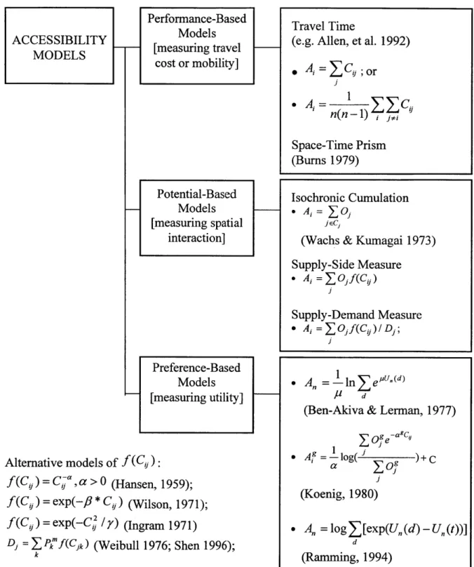
3.2 Accessibility Models: A Review 60
* The Concepts of Mobility and Accessibility 60 * Accessibility Models 62
(1) Performance-Based Models 64 (2) Potential-Based Models 64 (3) Preference-Based Models 66
3.3 The Accessibility Model Applied to This Research 68 3.4 Defining and Measuring Automobile Dependency 71
* Defining Automobile Dependency 71 * Measuring Automobile Dependency 75
3.5 Modeling Individual Trip Frequency 81
3.6 Land Use Indicators 83
3.7 Why Boston and Hong Kong? 84 3.8 GIS and DBMS Tools 86
Chapter 4 The Boston Case Study 89 4.1 Background Information 90
e The Study Area 90
* National and Regional Postwar Trends 93
e Mobility Supply in the Boston Area 96
4.2 Mode Choice/Accessibility and the Role of Land Use 108 " Data 108
e Mode Choice Modeling Results 116
4.3 Individual Trip Frequency and the Role of Land Use 121
* Qualitative Reasoning on Land Use Affecting Travel Behavior 121 * Trip Frequency Modeling Using Ordered Logit Regression 125
" Trip Frequency Modeling Using Generalized Ordered Logit Regression 131 4.4 Automobile Dependency and the Role of Land Use 136
* Measuring Automobile Dependency:
Single Coefficient Captivity Logit Modeling 137
* Explaining Automobile Dependency:
Parametrized Captivity Logit Modeling 147 4.5 Simulations of Pricing and Land Use Policy Effects 158
e Empirical Verification of Modeling Results 158
* Comparable Magnitude of the Effects of Pricing and Land Use on Travel 161 * Simulation #4.1: Driving Costs on Accessibility 163
* Simulation #4.2: Population Density on Accessibility 164
e Simulation #4.3: Driving Costs vs. Population Density
with Accessibility Held Constant 165
* Simulation #4.4: Driving Costs on Mode Choice Probabilities 166 * Simulation #4.5: Population Density on Mode Choice Probabilities 167
* Simulation #4.6: Combination of Density and Costs on Mode Choice Probabilities with Accessibility Held Constant 168
4.6 Chapter Conclusions 170
Chapter 5 The Hong Kong Case Study 171
5.1 Introduction 172
5.2 Background Information 176
5.3 A Case of Success in Transit-Based Mobility Supply 181
5.4 Explaining the Success 189
e Consistent Regional Transportation Strategies 189
* Diversified Public Transportation Systems 192 * Restrictive Automobile Policies 194
5.5 Mode Choice Modeling and the Role of Land Use 199
" Nested Logit Model Structure 202
e Estimation Results 206
5.6 Automobile Dependency in Hong Kong? 212
* Measuring Automobile Dependency:
Single Coefficient Captivity Logit Modeling 212 " Explaining Automobile Dependency:
Parameterized Captivity Logit Modeling 220
5.7 Simulations of Pricing and Land use Policy Effects 222
* Simulation #5.1: Driving Costs, Vehicle Ownership and Accessibility 224 * Simulation #5.2: Population Density, Parking Supply and Accessibility 227 * Simulation #5.3: Driving Costs vs. Population Density
with Accessibility Held Constant 230
" Simulation #5.4: Driving Costs, Vehicle Ownership
on Mode Choice Probabilities 231
" Simulation #5.5: Population Density, Public Parking Supply on Mode Choice Probabilities 234
" Simulation #5.6: Combination of Density, Public Parking Supply, Costs and Vehicle Ownership on Mode Choice Probabilities with Accessibility Held Constant 237
5.8 Chapter Conclusions 238 Chapter 6 Conclusions 239
6.1 Summary of Empirical Findings 240 " The Boston Case Study 240 " The Hong Kong Case Study 244 6.2 Policy Implications 247
* General Lessons Learned from the Boston and the Hong Kong Case Study 247 * Land Use-Based Mobility Strategies Revisited 249
* Overcoming Automobile Dependence 253 6.3 Contributions of the Research 258
6.4 Future Research 260 6.5 Concluding Remarks 262 References 263
Appendix: Technical Documentation 273 A.1 The Boston Case 274
A. 1.1 Data Management 274
A.l.2 MNL Mode Choice Modeling with SST 274
A.1.3 Captivity Logit for Automobile Dependence Modeling 290 A. 1.4 Trip Frequency Modeling with Ordered Logit and
Generalized Ordered Logit 292 A.2 The Hong Kong Case 293
A.2.1 Data Management 293
A.2.2 Nested Logit with HieLow for Mode Choice Modeling 293 A.2.3 Captivity Logit for Automobile Dependence Modeling 297
List of Figures
Chapter 2 The Premise of Land Use as a Mobility Tool Figure 2.1 Vehicle Miles Traveled in the US, 1960-98 28 Figure 2.2 Passenger Miles Traveled in the US, 1960-98 29
Figure 2.3 Energy Consumption vs. Urban Density in Global Cities 48 Chapter 3 Research Design and Methodology
Figure 3.1 Mobility vs. Accessibility 61
Figure 3.2 A Typology of Accessibility Measures 63
Figure 3.3 Space-Time Prism for an Individual Confronted with Trip Origin/Destination and Time Constraints 65 Figure 3.4 Database Diagram for the Boston Case Study 87 Figure 3.5 Database Diagram for the Hong Kong Case Study 88 Chapter 4 The Boston Case Study
Figure 4.1 Aerophoto: The Boston Downtown Area 89 Figure 4.2 The Boston Metropolitan Area 91
Figure 4.3 GDP per capita, Gasoline Price in the US, 1950-1994 94 Figure 4.4 Motorization in the US, 1960-1998 94
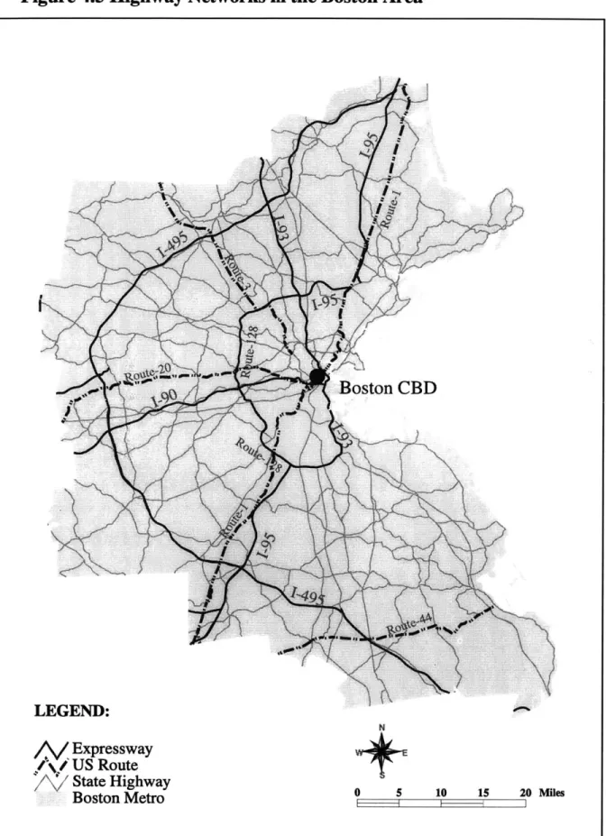
Figure 4.5 Boston Highway Networks 97
Figure 4.6 Spatial Distribution of Income in the Boston Area 101 Figure 4.7 Population Density in the Boston Area 103
Figure 4.8 Public Transportation Networks in the Boston Area 105 Figure 4.9a Spatial Patterns of Home-Based Work Trips
by Driving Modes in the Boston Area 111 Figure 4.9b Spatial Patterns of Home-Based Work Trips
by Non-Driving Modes in the Boston Area 113 Figure 4.10 Boston Suburban-Urban Cities/Towns 139
Figure 4.11 Driving Costs and Accessibility 163 Figure 4.12 Population Density and Accessibility 164 Figure 4.13 Iso-Accessibility Curves 165
Figure 4.14 Effects of Driving Costs (Toll and Parking) on Mode Choice 166 Figure 4.15 Effects of Population Density on Mode Choice 167
Figure 4.16 Combined Effects of Driving Costs and Density on Mode Choice 169 Chapter 5 The Hong Kong Case Study
Figure 5.1 Aerophoto: Kowloon and the Hong Kong Island 171 Figure 5.2 The Hong Kong Special Administrative Region 173 Figure 5.3 Real GDP Growth in Hong Kong, 1961-1998 176 Figure 5.4 Population Density in Hong Kong 179
Figure 5.5 Transit Routes and Stops on the Hong Kong Island in Hong Kong 183
Figure Figure Figure Figure Figure Figure Figure Figure Figure Figure Figure Figure Figure Figure Figure Figure
5.6 Major Highway and Rail Networks in Hong Kong 185
5.7 Registered Car/Vehicle Growth in Hong Kong, 1961-1998 197 5.8 Alternative Model Specification for Mode Choice Modeling 205 5.9 Spatial Distribution of Income Groups in Hong Kong 213
5.10 Driving Cost, Vehicle Ownership and Accessibility 224 5.11 Driving Cost, Motorization and Accessibility 225
5.12 Density and Accessibility (with fixed levels of parking supply) 229
5.13 Density and Accessibility (with varying level of parking supply) 229
5.14 Iso-Accessibility Curves 230
5.15 Effects of Density on Mode Choice (20 parking per 1000 jobs) 232
5.16 Effects of Density on Mode Choice (500 parking per 1000 jobs) 232
5.17 Effects of Density on Mode Choice (varying parking supply) 233
5.18 Effects of Driving Cost on Mode Choice
(low motorization: 65 vehicles per 1000 people) 235 5.19 Effects of Driving Cost on Mode Choice
(high motorization: 800 vehicles per 1000 people) 235
5.20 Effects of Driving Cost on Mode Choice (varying motorization) 236
5.21 Combined Effects of Driving Cost and Density on Mode Choice 237 Chapter 6 Conclusions
Figure 6.1 The Birdseye View of the Metropolitan Boston 240 Figure 6.2 The Birdseye View of Hong Kong 243
List of Tables
Chapter 2 The Premise of Land Use as a Mobility Tool
Table 2.1 Roadway Congestion Index in Selected US Metropolitan Areas 30 Table 2.2 Transit Ridership by Mode in the US (millions), 1920-1998 31 Table 2.3 Modal Share of Public Spending on Highways and Transit
in the US, 1956-94 32
Table 2.4 Urban Transit and Urban Automobile Passenger Miles (billions) in the US, 1945-97 32
Table 2.5 Total Person Trips by Mode and Trip Purpose (millions) in the US, 1995 33
Table 2.6 Built Environment-Travel Behavior Relationship 56 Chapter 4 The Boston Case Study
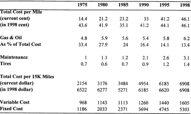
Table 4.1 Cost of Owning and Operating an Automobile in the US, 1975-98 95 Table 4.2a Motor Vehicle Registration Fees in Massachusetts, 2001 100 Table 4.2b License and Identification Card Fees in Massachusetts, 2001 107
Table 4.3: Descriptive Statistics for the Independent Variables 110 Table 4.4: Variable Definitions 115
Table 4.5a: Model Structure of Mode Choice for Home-Based Work Trips 117 Table 4.5b: Mode Choice Model for Home-Based Work Trips 118
Table 4.6 Ordered Logit Model of Trip Frequency: All Modes 127
Table 4.7 Ordered Logit Model of Trip Frequency: Non-Driving Modes 129 Table 4.8 Ordered Logit Model of Trip Frequency: Driving Modes 130
Table 4.9 Generalized Ordered Logit Model of Trip Frequency: All Modes 133 Table 4.10 Generalized Ordered Logit Model of Trip Frequency:
Driving Modes 134
Table 4.11 Generalized Ordered Logit Model of Trip Frequency: Non-Driving Modes 135
Table 4.12 Single-Coefficient Automobile Dependency Model: All Trips by Locations 138
Table 4.13 Single-Coefficient Automobile Dependency Model: All Trips by Income 141
Table 4.14 Single-Coefficient Automobile Dependency Model: Work Trips by Locations 142
Table 4.15 Single-Coefficient Automobile Dependency Model: Work Trips by Income 144
Table 4.16 Single-Coefficient Automobile Dependency Model: Non-Work Trips by Locations 145
Table 4.17 Single-Coefficient Automobile Dependency Model: Non-Work Trips by Income 146
Table 4.18: Parametrized Automobile Dependency Model: All Trips by Locations 148
Table 4.19: Table 4.20: Table 4.21: Table 4.22: Table 4.23: Table 4.24: Table 4.25:
Parametrized Automobile Dependency Model: All Trips by Income 149
Parametrized Automobile Dependency Model: Work Trips by Locations 154
Parametrized Automobile Dependency Model: Work Trips by Income 155
Parametrized Automobile Dependency Model: Non-Work Trips by Locations 156
Parametrized Automobile Dependency Model: Non-Work Trips by Income 157
Value of Time and Elasticities of Mode Choices 160
Pseudo-Beta Coefficients of MNL Mode Choice Model 162
Chapter 5 The Hong Kong Case Study Table 5.1 Land Use in Hong Kong, 1996 177
Table 5.2 Road Supply and Traffic Speed in Selected World Cities, 1990 182
Table 5.3 Vehicle and Private Car Ownership in Selected Countries/Regions, 1996 187 Table 5.4 Vehicle First Registration Fees in Hong Kong, 2000 195
Table 5.5 Vehicle License Fees in Hong Kong, 2000 196
Table 5.6 Sample Descriptive Statistics for Home-Based Work Trips 201 Table 5.7 Sample Mode Choice Distribution 203
Table 5.8a MNL Mode Choice Modeling Results 207
Table 5.8b NL Specification #1 Mode Choice Modeling Results 208
Table 5.8c NL Specification #2 Mode Choice Modeling Results 209 Table 5.8d NL Specification #3 Mode Choice Modeling Results 210 Table 5.9 Automobile Dependency Estimation: Region-wide 216
Table 5.10 Automobile Dependency Estimation: All Trips, by Income Groups 217 Table 5.11 Automobile Dependency Estimation:
Non-Work Trips by Income Groups 218
Table 5.12 Automobile Dependency Estimation: By Locations 219
Table 5.13 Parametrized Automobile Dependency Model: Non-Work Trips 221 Table 5.14 Pseudo-Beta Coefficients of NL Mode Choice Model 223
Unit and Currency Conversion
Hong Kong (Metric System) US (English System)
1 kilometer
1 square kilometers (sq. km.) 1 hectare
1 liter
= 0.622 mile
= 0.386 square mile (sq. mi.) = 2.47 acres
= 0.264 gallon (US)
1 Hong Kong dollar (HK$) = 0.128 US dollar (US$)
Chapter 1
Introduction
1.1 Problem Statement
1.2 Objectives and Research Questions 1.3 Structure of the Dissertation
1.1 Problem Statement
The growing public concern about the environmental and social problems of
transportation has motivated a global search for effective policy strategies to reduce motor vehicle travel (particularly the single-occupant auto travel), to enhance
accessibility of all population groups, and to achieve sustainable transportation. Many strategies have been proposed and they can be grouped largely into two approaches. One is the economic approach, that is, to "get the price right" to reflect the full costs of travel and hence to restore transportation market efficiency and to reduce the use of motor vehicles. Recommended measures include increasing vehicle registration fees, imposing higher fuel taxes, pricing road use, and eliminating free parking or parking subsidies. The
other is the land-use approach, that is, to "get the land use right" (in terms of development intensity, integration and urban form) to influence individuals' behavior and thus to promote environmentally and socially desirable travel. Suggested strategies include densification through infill-development, land-use mixing, traffic calming, job/housing balancing, and transit-oriented/neo-traditional neighborhood design*.
* A broader context of the pricing vs. land use debate is the evolvement of Travel Demand Management, or
TDM as an element of national transportation policy. TDM has been practiced in the US for over 30 years. Its main objective is to enhance mobility and to reduce congestion. The scope of TDM has been evolving and expanding, with the initial focus on improving the efficiency of the urban transportation system through operational improvements before the mid 1970's, and later incorporating concerns such as air quality and energy conservation into the transportation planning process since late 1970's. TDM includes a range of actions such as road system efficiency improvement and management, traffic control in congested areas, and encouragement of alternative travel like transit, walking, biking, and telecommuting. Pricing-based actions have been placed significant weight, although they are among the most difficult to implement. These actions are traditionally assumed to take place in a given land use context. The role of land use in TDM did not receive formal recognition until the early 1990's in the latest legislation such as the Clean Air Act Amendments (1990) and the Intermodal Surface Transportation Efficiency Act (1991) (Meyer 1999).
While there is a general agreement among policy analysts on the necessity to tackle the environmental and social problems associated with the private vehicle-dominated travel, there has been heated debate on the effectiveness of those suggested strategies. In
challenging the idea of "getting the land use right," the proponents of "getting the price right" argue that the linkage between land use and transportation is weakening in the U.S.
and other developed countries due to decreasing real costs of travel, existence of already well-developed transportation systems, and structural shifts to an information-based economy (Gordon, et al. 1991, Giuliano 1995 and Dunn 1998). Therefore, attempts to alter land use patterns via rezoning or urban design may not have much effect on travel. According to them, the effective remedies to the problems associated with existing travel are to directly price and regulate autos and their use. As long as prices can be set at the proper levels to reflect the real costs of travel, the transportation market would correct by itself to eliminate excessive automobile usage and the associated undesirables. In turn, the land use market would also behave in response to the transportation costs.
Researchers in this area pay most attention to finding the real costs of travel and to the implementation technologies and strategies of the pricing policies. In the analyses on travelers' response to pricing, land use variables are generally treated as fixed and thus left out of the policy formulation.
The proponents of "getting the land use right," on the other hand, maintain current land use requires and therefore causes current travel. In addition, true market pricing of transportation is unattainable, especially in a pluralistic, democratic society like the US. Land use planning is then the next best thing that can and should be done (e.g. Cervero
1989, 1991, Cervero and Landis 1995, Newman and Kenworthy 1989, 1999). The proponents of this argument believe that land use planning is a viable mobility tool. Reconfiguring urban and regional land use will alter regional travel demand patterns and lead to more desirable outcomes. The majority of the literature along this line has focused on finding the evidence or proving the significance of land use impacts on travel, and on initiating land use-based transportation strategies.
There is an implicit assumption underlying the arguments made by both sides of the debate: economic measures and land use initiatives are substitutable; either approach alone is thought sufficient to correct the transportation and land market failure. This assumption leads the current debate often to a dichotomous mode, and economic
measures and land use initiatives have been largly considered and analyzed in separated domain. This leaves a research gap in policy analysis: Few studies have been done to examine the interactive and collective effects of economic and land use-based strategies on travel, although the importance for policy analysis of emphasizing the interactions and complementary effects of these different strategies has been pointed out by a number of
scholars (e.g. Crane & Crepeau 1998, Levine 1998).
Another important source of debate comes from the conflicting interpretations of the observed correlation between the built environment and travel outcomes. It has been widely accepted that travel demand (by and large) is derived from the demand to
participate in activities such as work, shopping, leisure, etc. (Mitchell and Rapkin 1954, Jones, et al. 1983). Therefore the distribution patterns of activities and residential locations (i.e. land use patterns) basically define the spatial patterns of travel demand. One may thus expect that the characteristics of the built environment in which people live or work explain to a significant extent the way people travel. On the other hand, one may also theorize that the geographical patterns of land use and travel demand are
simultaneously determined by exogenous factors such as technological progress and the structure of transportation costs (Pickrell 1999a). A causal relationship between built environment characteristics and people's travel decisions may be indirect or nonexistent.
These mixed interpretations lie in the fact that the relationships between the built environment and travel behavior are very complex. Crane (1999) has warned that our current understanding of the relationships between land use and transportation is not enough to provide sufficient credibility to be the basis for policy. It is therefore imperative to better understand how specific aspects of travel behavior (such as trip making and mode choice) are related to particular attributes of land use (such as density and urban form). Researchers continue to investigate the connections between the built
environment and people's travel decisions in order to establish a solid behavioral ground for public policy making.
Joining the long and ongoing debate, this dissertation examines the potential of land use as a mobility tool to affect travel. It is aimed to better inform the policy debate by
improving understanding of the relationships between the built environment and people's travel behavior, and by investigating the complementarities between land use and
economic measures in affecting travel. The dissertation presents two case studies of world cities: Metropolitan Boston and Hong Kong, where there are sharp contrasts in land use, travel patterns, cultural settings, and transportation policy practice (The reasons in selecting these two cities are discussed in Chapter 3). Taking a disaggregate approach, the empirical analysis builds on the economic choice theory and focuses on three aspects of travel behavior: mode choice, trip frequency and automobile dependence. The analysis makes use of a set of choice modeling tools. Logit models of mode choice and trip
frequency are estimated to examine the importance and magnitude of land use affecting travel when travel costs and socio-demographic factors are controlled for. The effects of densification and pricing on mode choice are extrapolated with incremental logit
modeling while controlling for the impacts of these policies on individual accessibility. Accessibility, measured at the individual level as the utility associated with all available modes, serves to link together household/individual travel decision, transportation and land use policy instruments, and the policy goal (of enhancing accessibility). Automobile dependence is the critical concern to the public and the policy makers and therefore is investigated in greater detail. It is interpreted in this study from the perspective of individuals' travel choice and examine in the process of choice set generation. Logit captivity models are estimated to quantify and explain automobile dependence in relating to transportation, land use, economic, and socio-demographic factors. The main
conclusion of this study is that either land use or pricing is necessary but not sufficient policy to achieve the environmental and social objectives of transportation. For them to be effective and practical, the two should act together as complements. The mobility role of land use is to modify transportation supply and to support expansion of travel choices, whereas pricing is to manage and redirect vehicle travel demand.
1.2 Objectives and Research Questions
This dissertation research is aimed to achieve the following objectives:
* To examine the built-environment/travel-behavior relationships in an integrated framework that is built on the economic choice theory and to explicitly quantify and explain automobile dependency with simultaneous consideration of transportation pricing, transit supply, land use and socioeconomic factors;
* To investigate the complementarities between land use and economic measures in affecting travel and consequently to identify the potential that land use constitutes an effective mobility tool to achieve the social and environmental objectives of
transportation;
* To contribute to the literature by investigating two special cases of world cities (metropolitan Boston and Hong Kong) at the disaggregate level, and to promote international learning in effective mobility supply and accessibility enhancement and in searching for sustainable transportation strategies.
To achieve these objectives, the following specific questions are addressed:
(1) Are there still significant relationships between the built environment and individuals' travel behavior (i.e. mode choice and travel demand) after important behavioral factors (e.g. prices, resources and preferences) are taken into account? A large body of literature has been devoted to the topic of the relationships between the built environment and travel behavior (e.g. Friedman et al. 1994, Cervero and Kockelman 1997, Newman and Kenworthy 1989, 1999). The study approaches range from simple comparisons or bivariate correlation analyses in travel outcomes among neighborhoods or cities with different land use characteristics to sophisticated multivariate analyses. The results reported, however, are rather mixed. Some have concluded that land use variables are strong explainers of travel behavior while others found little of such evidence. One
common problem existing in many of these studies, as they have been criticized by a number of scholars (e.g. Gomez-Ibanez, J.A., 1991, Crane 1999, and Pickrell 1999a), is their omission of important variables such as income, price and/or transportation supply. In this research, we attempt to rigorously control for the effects of these behavioral variables.
(2) How does land use 'cause' changes in people's travel behavior? This is both a theoretical and empirical question concerning individual travel demand. The issue of causation has been a major challenge to researchers in explaining the observed empirical evidence on the built environment/travel behavior connections. Hence, the potential of land use planning as a mobility tool has often been questioned. Many advocates of land use-based mobility strategies themselves are cautious in interpreting their observed land use/travel behavior relationships as associative rather than causal (e.g. Cervero and Kokelman 1997). This is because when cross-sectional data are used to measure the associated effects, the true causality is largely indeterminate. Technically, the direction of causation can be better observed if time-serial models and temporal data are utilized. Unfortunately, such data rarely exist or are too expensive to collect. Furthermore, land use changes generally do not appear in a short period of time. When time goes by, other factors affecting travel behavior such as transportation technologies come into play, masking the true effects of land use. This creates a research dilemma in that the question of whether land use causes changes in individuals' travel behavior seems untestable. In this thesis, we attempt to address the question by qualitative reasoning within a
behavioral framework of travel demand in combination with empirical modeling of individual trip making.
(3) What is the nature of automobile dependency? How to quantify the degree of automobile dependency for a given population group or in a given geography? What factors do contribute to automobile dependency? The policy concern over automobile dependence relates not only to transportation services but also to the quality of life in general. Automobile dependency has been linked to many undesirable consequences of driving such as congestion, environmental degradation, personal distress and health
problems. Reducing automobile dependency has become one of the main objectives of contemporary transportation planning and policies.
Unfortunately, little is known about the nature of automobile dependency except for such general statements as 'people like their cars' or 'they don't have other alternatives'. Understanding how and to what extent various social, economic, spatial, and
idiosyncratic factors contribute to people's automobile dependency is important to public policy making that aims to reduce the undesirable social and environmental consequences associated with auto travel, and to improve the quality of urban and suburban life at large. To those who are captive to automobile due to social or spatial constraints, policy
strategies designed to improve alternative travel and social services would be more desirable (than punitive policies such as pricing). On the other hand, to those who depend on automobile for attitudinal reasons, economic approach such as pricing would be necessary and more effective. In this research, we attempt to advance the research on automobile dependence by explicitly modeling and quantifying it.
(4) What are the comparable magnitudes of the effects of economic measures and land use initiatives on travel? Most existing studies have focused on proving that toll and parking charges, land use density, land use mix, or urban form do or do not have impacts on people's travel decision making. It is of course useful to learn the directions of the effects that these factors potentially have on travel. For the purpose of policy making, it is even more important to know the magnitude of the effect, if any, or the extent of changes that policy action would induce.
Despite the disagreements, one thing in common among the advocates of different policy solutions is that they all expect behavioral changes in individuals' travel or location decisions in response to the implementation of the recommended policies. In evaluating the effectiveness of these policy options, it is then fundamental to ask whether or not individuals' behavior adjustments would take place to the extent expected.
(5) How do land use initiatives interact with economic measures in affecting travel? To what extent and under what conditions can land use initiatives effectively affect people's mobility choices and travel decisions? What lessons can be learned from the two case studies (i.e. Metropolitan Boston and Hong Kong) in land use development and transportation policy making? We address these questions by arguing that economic measures and land use initiatives reflect the two sides of one coin--they are inherently complementary.
1.3 Structure of the dissertation
Chapter 1, this chapter, introduces the issues concerned, states research objectives and questions, and describes the structure of tl-e dissertation.
Chapter 2 explains the motivation of the research based on the literature review on topics pertaining to the transportation pricing/land use policy debate, to the
built-environment/travel-behavior relationships, and to automobile dependence. From the literature review research needs are identified, which leads to the research design described in the following chapter.
Chapter 3 starts with a summary of the research design. It then provides a review of accessibility models, along with a general description of the concepts of mobility and accessibility. Within that context, the specific accessibility model applied to this research is introduced. Next, it gives a behavioral interpretation and an operational definition of automobile dependence and explains the extension of the mode choice modeling framework for the measurement of automobile dependence. The statistical tools used to analyze individual travel demand, i.e. trip frequency are described subsequently. The reasons why metropolitan Boston and Hong Kong are selected as our empirical study cases are given in the following part. Finally, it describes the ways that data sets are organized and managed using computational tools such as geographic information system (GIS) and database management system (DBMS).
In Chapter 4 we present the study on the Boston case, addressing the research questions stated in Chapter 1. We first provide the basic social, demographic and geographical information about the study area in the Greater Boston. National and regional postwar trends in urban and transportation development are also briefly reviewed. The mobility supply in the study area in terms of road networks and transit services are described in more detail. The major contents of this chapter include three sections on the empirical modeling of the built-environment/travel-behavior relationships focusing on travel mode choice, trip frequency, and automobile dependence. The fourth section is devoted to
simulation analysis of the policy effects on travel behavior based on the empirical.results. The chapter ends with a chapter conclusion.
-Chapter 5 is on the Hong Kong case study. Beginning with the background information on Hong Kong, the Chapter starts presenting a case of success on transit-based mobility supply. It then accounts for factors important to Hong Kong's success in maintaining sufficient mobility and accessibility to its citizens. Parallel to the Boston case, mode choice modeling, automobile dependence measurement, and policy effect simulations are presented next.
Chapter 6 first summarizes the results of the Boston and Hong Kong case studies. It then draws policy implications based on the findings from studying the two cases.
Contributions of this dissertation and areas of future research are highlighted next. The chapter ends with concluding remarks.
The appendix includes technical notes and programming codes for data processing and modeling of mode choice and automobile dependence.
Chapter 2
The Premise of Land Use as a Mobility Tool
2.1 The Signs of the Transportation Market Failure 2.2 Land Use-Based Mobility Strategies
2.3 Conflicting Evidence of Land Use's Mobility Role 2.4 Research Needs
2.1 The Signs of the Transportation Market Failure
Current travel patterns are generally believed the indication of the transportation market failure in the metropolitan US. Following stylized facts portray such travel patterns.
0 Excessive Travel
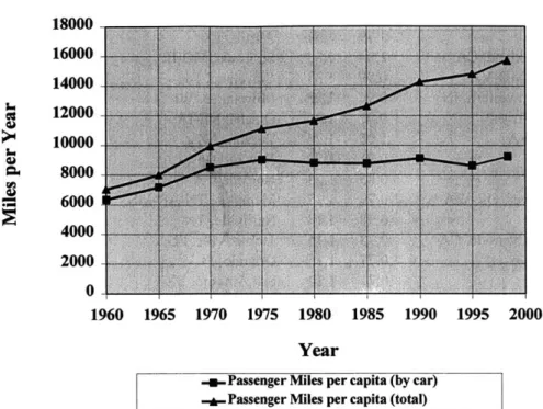
People travel extensively, and are traveling more and more. In 1998, annual vehicle miles-traveled in the US was 9,745 miles per capita (highway travel only), a 145% increase from 1960 (Figure 2.1). Travel by passenger cars also increased by 77% during the same time period. The excessive travel is further shown by the trend of passenger-miles traveled over time (Figure 2.2). Although car-based passenger passenger-miles traveled have been stable around 9,000 miles per capita per year, passenger miles traveled by all types of vehicles (including passenger cars, light trucks, motorcycles, and buses) have been continuously increasing, reaching 15,715 miles per capita in 1998. If we assume an average travel speed of 45 miles per hour, the annual travel figure translates to a total of 349 hours per person per year. In other words, on average, every American spent about two months traveling around, assuming that they traveled 8 hours per day in the two month period and that they did have weekends off.
The excessive travel is accompanied by the large and growing consumption of energy. In 1999, the transportation sector consumed over 26 trillion BTU of energy, and it
accounted for 67% of end-use consumption of petroleum products in the US (US DOE, 2000). The excessive travel also imposes significant impacts on the environment. In the
US, transportation accounts for about one third of total greenhouse gas emissions, of which 60% are from cars, 15% from tnicks, and the rest from ships, aircraft, etc. (Pickrell 1999). The growing energy consumption by transportation and increasing impacts on the environment have raised serious concerns over the long term sustainability issues that cannot be adequately dealt with by the transportation market itself.
Figure 2.1 Vehicle Miles Traveled in the US, 1960-98
12000
10000 8000 6000 4000 2000 0 196 17 1960 1965 1970 1975-u-Car Miles per capita Source: Bureau of Transportation Statistics, 2000
1980 1985 1990 1995 2000
Year
-- Veh Miles per capita
Figure 2.2 Passenger Miles Traveled in the US, 1960-98 18000 16000 14000 0 12000 10000 8000 6000 4000 2000 0 1960 1965 1970 1975 1980 1985 1990 1995 2000 Year
-+-Passenger Miles per capita (by car) -*-Passenger Miles per capita (total)
Source: Bureau of Transportation Statistics, 2000
e Road Congestion
Despite large investments in road infrastructure, road congestion is becoming worse in many major US metropolitan areas. Table 2.1 shows the Road Congestion Index (RCI)*
indicating the congestion levels from 1982 to 1997 in selected areas, including 50 largest urban areas in the country. In 1997, 38 out of the 68 selected urban areas have RCI
exceeding 1.0, a threshold that indicates the undesirable congestion level. Estimated congestion costs in 1997 for these urban areas were $72,205 million (TTI, 1999).
* RCI is measured as follows:
RCI = (FreewayVMTperLaneMib) * (FreewayVMT) + (ArteialVMTperLaneMie) * (ArterialVMT)
13,000 * FreeywayVMT + 5,000 * ArterialIVMT
where 13,000 and 5,000 VMT/lane are the system-wide congestion indicator levels for freeways and for principle arterial roads, respectively. RCI is essentially a measure of average vehicle travel density on major roadways in an urban area. It therefore does not reflect the congestion levels of specific routes or segments of road. When congestion occurs, travel speed decreases, resulting from less flow over the congested segments. When it is too congested, traffic flow becomes close to static. RCI as an aggregate measure does not represent the micro level traffic conditions. Furthermore, it does not consider local roads and streets, which most of the time in a day are free of congestion.
Table 2.1 Roadway Congestion Index in Selected US Metropolitan Areas 1982 1997 Urban area 1982 1997 Los Angeles, CA San Francisco-Oakland, CA Washington, DC-MD-VA Chicago, IL-Northwestern, IN Miami-Hialeah, FL Seattle-Everett, WA Boston, MA Atlanta, GA Portland-Vancouver, OR-WA Detroit, MI San Bernardino-Riverside, CA Tacoma, WA Sacramento, CA Minneapolis-St. Paul, MN Phoenix, AZ San Diego, CA
New York, NY-Northeastern, NJ Cincinnati, OH-KY Denver, CO Fort Lauderdale, FL San Jose, CA Houston, TX Las Vegas, NV Tampa, FL Honolulu, HI Albuquerque, NM Baltimore, MD Indianapolis, IN Philadelphia, PA-NJ Charlotte, NC Columbus, OH Dallas, TX Louisville, KY-IN Salt Lake City, UT
1.39 1.04 0.99 0.94 0.97 1.05 0.91 0.85 0.79 0.98 0.73 0.77 0.71 0.7 0.94 0.8 0.94 0.81 0.77 0.7 0.76 1.09 0.67 0.91 0.86 0.69 0.78 0.62 0.98 1.08 0.61 0.77 0.72 0.68 1.51 1.33 1.33 1.28 1.26 1.26 1.24 1.23 1.22 1.18 1.15 1.15 1.14 1.13 1.13 1.12 1.11 1.08 1.08 1.08 1.08 1.07 1.07 1.07 1.06 1.05 1.05 1.05 1.05 1.04 1.04 1.04 1.04 1.04
NOTES: The roadway congestion index (RCI) is a measure of vehicle travel density on major
roadways in an urban area. An RCI exceeding 1.0 indicates an undesirable congestion level, on average, on the freeways and principal arterial street system during the peak period.
SOURCE: 1982-97: Texas Transportation Institute, The 1999 Annual Urban Mobility Report
(College Station, TX: 1999), Appendix A-4.
Page 30 -- Chapter 2 The Premise of Land Use as a Mobility Tool Urban area Austin, TX St. Louis, MO-IL Cleveland, OH Milwaukee, WI Omaha, NE-IA Tucson, AZ New Orleans, LA Norfolk, VA Memphis, TN-AR-MS Nashville, TN Jacksonville, FL Orlando, FL San Antonio, TX Fort Worth TX Beaumont, TX Fresno, CA Hartford-Middletown, CT Providence-Pawtucket, RI-MA El Paso, TX-NM Oklahoma City, OK Eugene-Springfield, OR Salem, OR Spokane, WA Boulder, CO Rochester, NY Colorado Springs, CO Kansas City, MO-KS Pittsburgh, PA Albany-Schenectady-Troy, NY Bakersfield, CA Buffalo-Niagara Falls, NY Corpus Christi, TX Brownsville, TX Laredo, TX 0.78 0.81 0.75 0.76 0.67 0.79 0.89 0.75 0.76 0.71 0.84 0.65 0.73 0.73 0.67 0.81 0.69 0.79 0.66 0.57 0.54 0.57 0.64 0.64 0.53 0.62 0.56 0.72 0.48 0.47 0.6 0.67 0.53 0.52 1.03 1.03 1.01 1.01 1 1 0.99 0.97 0.96 0.96 0.93 0.93 0.92 0.91 0.9 0.9 0.9 0.87 0.86 0.85 0.84 0.82 0.81 0.8 0.78 0.77 0.76 0.76 0.75 0.75 0.72 0.72 0.71 0.61
* Modal Mismatch of Demand and Supply
While highway travel demand continues to grow, transit ridership has been declining. In 1998, national transit ridership was only slightly over half of the 1920 level (Table 2.2). From 1960 to 1998, the US population increased by 49%. The transit ridership, however, was down by 7%. In spite of growing share of public spending on transit since the 1950's (Table 2.3), transit share of total urban passenger miles keeps declining (Table 2.3). In
1997, transit share of total urban passenger miles was merely 2%, a result of long term decrease since World War II (Table 2.4).
Table 2.2 Transit Ridership by Mode in the US (millions), 1920-1998
Year Bus Heavy Light Commuter Other Total
Rail Rail Rail
1920 -- 1,792 13,770 -- -- 15,562 1930 2,481 2,559 10,530 -- 16 15,586 1940 4,255 2,382 5,951 -- 542 13,130 1950 9,447 2,264 3,904 -- 1,686 17,301 1960 6,425 1,850 463 -- 657 9,395 1970 5,037 1,881 235 -- 182 7,332 1980 5,837 2,108 133 280 209 8,567 1990 5,677 2,346 175 328 273 8,799 1998 5,387 2,393 275 382 309 8,746
Source: Luberoff and Altshuler, 1999
Table 2.3 Modal Share of Public Spending on Highways and Transit, in the US, 1956-94
Year Total Spending Highways Transit
(billions, in 1997$) 1956 $44.60 92% 8% 1960 $55.80 93% 7% 1964 $66.50 93% 7% 1968 $74.40 91% 9% 1972 $74.90 90% 10% 1976 $67.00 85% 15% 1980 $74.30 81% 19% 1984 $77.50 76% 24% 1988 $92.50 78% 22% 1992 $104.00 77% 23% 1994 $109.70 75% 25%
Source: Luberoff and Altshuler, 1999
Table 2.4 Urban Transit and Urban Automobile Passenger Miles (billions) in the US, 1945-1997 Transit 130 90 60 48 43 41 38 40 40 41 38 42 Auto 240 403 515 627 786 1,089 1,341 1,288 1,400 1,533 2,024 2,106 Transit Share 35% 18% 10% 7% 5% 4% 3% 3% 3% 3% 2% 2% Source: Luberoff and Altshuler, 1999
Page 32 -- Chapter 2 The Premise of Land Use as a Mobility Tool
Year 1945 1950 1955 1960 1965 1970 1975 1980 1985 1990 1995 1997
. Automobile Dependence
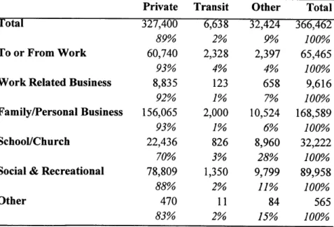
Most North American communities are believed automobile dependent (Newman and Kenworthy 1999, Litman 1999). In these communities, the use of automobile is not so much a choice but a necessity. According to Newman and Kenworthy, US cities (along with Australian cities) are the most extensive in their dependence on the automobile, three to four times more than the European cities. American's dependence on automobile is characterized by the high per capita transportation use of energy (2.5 times higher than that in the Europe), the dominant role of cars among travel modes, generous road and parking supply, and low density suburban sprawl that support and require car use. The 1995 Nationwide Personal Transportation Survey shows that in the US, 86% of total person trips were made by private vehicles. Private mode of transportation served for over 90% of all commute and personal business trips (Table 2.5 ).
Table 2.5 Total Person Trips by Mode and Trip Purpose (millions) in the US, 1995
Private Transit Other Total
Total 327,400 6,638 32,424 366,462
89% 2% 9% 100%
To or From Work 60,740 2,328 2,397 65,465
93% 4% 4% 100%
Work Related Business 8,835 123 658 9,616
92% 1% 7% 100%
Family/Personal Business 156,065 2,000 10,524 168,589
93% 1% 6% 100%
School/Church 22,436 826 8,960 32,222
70% 3% 28% 100%
Social & Recreational 78,809 1,350 9,799 89,958
88% 2% 11% 100%
Other 470 11 84 565
83% 2% 15% 100%
Source: Nationwide Personal Transportation Survey, 1995
2.2 Land Use-Based Mobility Strategies
It is generally agreed that one of the main causes of current Transportation market failure is the mis-pricing of private vehicle use. Charging motorists prices that reflect the long-run social costs of driving is therefore considered the most direct, effective measure to correct the market failure. However, political barriers make such measure unfeasible to implement, at least in the near future.
Many have thus argued that land use should play the role, because the transportation market failure is closely related to the land use practice prevailing in the urban and suburban communities. It is believed that people are traveling long distances because jobs, stores, shops, and other services are located far away from where they live; they make frequent trips because these service facilities are segregated and isolated, which generate more single-purpose trips than the case with mixed-use development; they rely on automobiles too much because there are no other viable options such as transit, which is not efficiently supported by existing land use patterns. Accordingly, many land use initiatives have been recommended, and some are being practiced nation-wide, aiming to alter current travel patterns. Following four are believed the most effective, land use-based mobility initiatives. They are closely related and, in practice, are often jointly implemented.
9 Densification
Density is considered the single most important land use factor that affects travel (Newman and Kenworthy 1989, 1999). Suggested desirable density is 18 units per acre (or FAR of 2.0), which is necessary to achieving mode splits in the 15 to 20 percent transit share. Densification is recommended at both ends of the commute trip.
. Mixed-Use Developments
Mixed-use places compatible activities side-by-side so that they mutually benefit from one another. The transportation benefits of mixed-use developments are believed to include: increased walk trips; evenly distributed trip-making throughout the day and week; higher likelihood of carpool or vanpool (Duany, et al. 1991).
* Job-Housing Balance
The idea of job-housing balancing is to provide opportunities for people to live reasonably close to their workplaces. It requires balanced distribution and diversified housing and job opportunities in a given area. Job-housing balance reduces cross-zone commuting that has been currently spreading out in many metropolitan areas (Cervero 1991).
e Site Planning and Design Practices
Design-based strategies include neotraditional neighborhood design, transit-oriented development, and traffic calming (Duany, et al. 1991, Calthorpe 1993, Ewing 1999). The basic idea is to design the built environment that is more pleasant for walking, biking, which helps create a sense of place and promotes human interactions. Expected
transportation benefits are that more pedestrian-friendly work environments could attract larger numbers of suburban employees to vanpools, carpools, and transit.
2.3 Conflicting Evidence of Land Use's Mobility Role I
How effective are these land use-based mobility tools? There have been heated debates among policy analysts. Mixed evidence is reported in the literature. Below we review related literature and design our research with detailed examination of previous studies
and findings.
0 The 'Transportation/Land-Use Connection' Debate
An important issue pertaining to the effectiveness of land use as a mobility tool is whether the evolving land-use and transportation connections offer any significant potential for land use to play a role in influencing people's mobility choice and in modifying urban accessibility. Historically, land-use and transportation developments have been closely related. Frequently cited example is the strip-type land use
development patterns in the street-car era. In the automobile era, however, such close connections between land use and transportation development are no longer as obvious since automobile has provided almost ubiquitous access. If the connections between land-use and transportation become weakening, the role of land land-use as a mobility tool would be diminishing.
Giuliano and Small (1995) suggest that this is what's happening to contemporary cities, particularly in urban America. They list a number of reasons. First, transportation costs are low relative to housing costs and the real cost of commuting has dropped dramatically over time. Rising income increases demand for more space (lower density) and cleaner air (farther away from central city). Transportation is of declining importance in the locational decisions of households and firms. Second, American cities are already built up with highly developed transportation systems, which have long life. The relative impact of even major transportation investments is minor. Studies in Los Angeles and Oregon show that land use policies (e.g. densification) and transportation policies have to be truly extreme to have significant impact on mode shares, trip lengths and urban form.
Third, structural economic shifts to information-based activities engender
decentralization. It allows more flexible work arrangements (temporal and spatially) and less clustering among firms. This implies more spatial dispersion.
Cervero and Landis (1995) take a contrary position. They argue that the existing land use and travel patterns are the outcomes in a distorted market of cheap auto usage, not representing the true land use-transportation relationships. They challenge that Giuliano and Small's findings and conclusions are based on questionable information or examples, i.e. modeling results with unrealistic assumptions, stated-preference survey, and
incomplete trip data. In contrast, they cite studies in which strong capitalization effects are found for proximity to San Francisco's BART and San Diego's light rail system. In the case of freeway accessibility, the opposite effect is observed. They conclude that the land-use/transportation connection still matters and public policy plays a vital role in shaping the connection. True market pricing of transportation is more unattainable than strengthening transportation-land use linkages in a pluralistic, democratic society. In the absence of true market-based pricing of travel, land use policies are among the next best things.
Pickrell (1999) tells a more detailed story on transportation/land-use relationships. He observes that urban development represents the cumulative effect of incremental
improvements to the transportation technologies. In this cumulative development process, the effect of innovations in transportation technology on development pattern is exerted primarily within the expanded portion of growing urban areas. Since technological improvements eventually translate to reduction of the time or monetary costs of travel, each successive innovation in passenger transportation, including urban transit and automobile, contributes in turn to metropolitan decentralization and lower development densities than in preceding eras.
Another feature related to the cumulative effect is that, because of the durability of the urban (infra)structures, even massive investments in the capital infrastructure represent comparatively modest additions to the cumulative value of investments that are already in
place. Therefore, the role of transportation in location and land use decisions is likely to have weakened over time. Changes in travel costs fostered by technological innovation and investment are likely to be much smaller than was historically the case.
Pickrell thus concludes that, although the historical effect of transportation on land use has been pronounced, current and foreseeable technological innovations and investment levels are unlikely to have comparably large effects. Consequently, the influence of land use patterns on the volume and geographic pattern of urban travel is modest. "Land use planning as a means to mitigate externalities such as traffic congestion and air pollution
generated by urban transportation thus seems unlikely to be an effective substitute [emphasis added] for rationalizing investment levels and pricing policies in urban transportation." (p.432)
e Evidence of Land Use Having/Having No Influence on Travel: Regional
Scale
Many empirical and simulation studies have been done searching for evidence of land use having or having no influence on travel. One approach is to examine, at the regional scale, whether travel patterns are attributable to urban spatial structure.
Cervero (1989a, 1989b) and Downs (1989) have hypothesized that imbalances and mismatches between jobs and housing cause long commutes and increase highway congestion. Imbalances occur when the number of workers who can be housed in an area differs substantially from the number of jobs located in the area. Mismatches occur when prices or other characteristics make housing in the area unsuitable for the works who hold jobs there. Both make inter-area commutes necessary and longer than the balanced and matched case. They contend that the continuing lengthening of commuter trips and the marked deterioration of traffic conditions is partly due to a widening job-housing
imbalance in many metropolitan areas across the country. The spatial mismatch between the location of jobs and the location of affordable housing is forcing growing numbers of