HAL Id: tel-01631400
https://tel.archives-ouvertes.fr/tel-01631400
Submitted on 9 Nov 2017HAL is a multi-disciplinary open access archive for the deposit and dissemination of sci-entific research documents, whether they are pub-lished or not. The documents may come from teaching and research institutions in France or abroad, or from public or private research centers.
L’archive ouverte pluridisciplinaire HAL, est destinée au dépôt et à la diffusion de documents scientifiques de niveau recherche, publiés ou non, émanant des établissements d’enseignement et de recherche français ou étrangers, des laboratoires publics ou privés.
Construction Site Layout Optimization, Considering
Risk of Natural or Technological Hazard Utilizing GIS
Mohammed Abune’Meh
To cite this version:
Mohammed Abune’Meh. Construction Site Layout Optimization, Considering Risk of Natural or Tech-nological Hazard Utilizing GIS. Other. Université Paris-Est, 2017. English. �NNT : 2017PESC1012�. �tel-01631400�
Construction Site Layout
ALHEIB Marwan AFRA Hamid MEBARKI El MEOUCHE HIJAZE Ihab SHAHROUR BERAUD HélèneConstruction Site Layout
Natural or Technological Hazard
ALHEIB Marwan AFRA Hamid EBARKI Ahmed MEOUCHE Rani Ihab HAHROUR Isam BERAUD Hélène
En
Construction Site Layout
Natural or Technological Hazard
Ecole des Mines de Nancy CNERIB/ENSTP Université Paris ESTP Paris An-Université Lille1 UPEM
Thèse
En vue de l'obtention du titre de
D
OCTEURDe L'Université
Spécialité
École doctorale
Construction Site Layout Optimization
Natural or Technological Hazard
MOHAMMED
Soutenue
Ecole des Mines de Nancy CNERIB/ENSTP
Université Paris ESTP Paris
-Najah National University Université Lille1
UPEM
Thèse
vue de l'obtention du titre de
OCTEUR
Université Paris
Spécialité
:GENIE CIVIL
doctorale
Optimization
Natural or Technological Hazard
OHAMMED ABUNEMEH
Soutenue le 24 Mai 201
Jury:
Ecole des Mines de Nancy CNERIB/ENSTP
Université Paris-Est
Najah National University Université Lille1
vue de l'obtention du titre de
Paris-Est
ENIE CIVILdoctorale
:SIE
Optimization, Cons
Natural or Technological Hazard Utilizing GIS
BUNEMEH Mai 2017 France Algeria France France Najah National University Palestine
France France
onsidering Risk of
tilizing GIS
France Rapporteur Algeria Rapporteur Président France Directeur France Co thèse et Palestine Examinateur France Examinateur France Examinateuridering Risk of
tilizing GIS
Rapporteur Rapporteur et Président du Jury Directeur de thèse Co-encadrant de thèse et Examinateur Examinateur Examinateur Examinateuridering Risk of
du Jury de thèse encadrant de Examinateur
A
CKNOWLEDGMENTS
All praise and thanks are due to Almighty Allah, Most Gracious and Most Merciful, for his immense beneficence and blessings. He bestowed upon me health, knowledge, and patience to complete this work.
During my Ph.D. studies, I have met many persons who left a great impact on my life either personally or scientifically. Their presence was vital for my accomplishments and success; thus, I dedicate the following unpretentious words to express my gratefulness and to acknowledge their help each in their own way.
I acknowledge, with deep gratitude and appreciation, the inspiration, the encouragement, the valuable time and the continuous guidance given to me by my thesis advisor, Prof. Ahmed MEBARKI. I am also grateful to my Co-advisors, Dr. Rani ELMEOUCHE, Dr. Ihab HIJAZE,and Dr.
Isam SHAHROUR for their constructive guidance and support, their valuable suggestions, and
comments throughout the study.
Thereafter, acknowledgments are due to ESTP-Paris for the support extended towards my research through its remarkable facilities and for granting me the opportunity to pursue graduate studies. My sincere appreciations and prayers are due to all administration staff in the MSME lab and in PARIS-EST. University for their endless assistance. Finally, special thanks are due to my
colleagues in the university and in ESTP-Paris, for their help and prayers.
Really, I am lucky to have family who supports me all the time despite the long graphical distance that separated us over the last three years. Therefore, I am thankful for my mother, my father, my brothers and my sisters. I believe that this dream would never have become a reality without their encouragements.
I am also thankful to my fiancée Zahra for her support, kindness, patience over the last two years of my Ph.D. study. Her existence in my life was a mighty bless.
Finally, I have tried my best to avoid any mistakes or inaccurate data and information in this study. I apologize for any mistake that was beyond my understanding and knowledge, and may ALLAH forgive me.
To My Beloved Family & My Fiancée,
For their endless support, patience, continuous
prayers and encouragement led to this
v
Abstract
Construction Site Layout Optimization, Considering Risk of Natural or
Technological Hazard Utilizing GIS
Construction sites contain several supporting facilities that are required to complete construction activities. These facilities are susceptible to damage due to the occurrence of natural or technological hazards such as fire, explosion, blast wave, and so on. These may cause adverse consequences for the whole construction process, which in turn lead to fatal accidents that have a major impact on worker and employee productivity, project completion time, project quality and project budget. Therefore, project planners must adopt and develop innovative approaches able to face the occurrence of potential hazards, minimize their consequences, and facilitate the evacuation of the site in case of their occurrence. One of these approaches is optimizing construction site layout. In general, generating construction site layout able minimizing risk resulting from natural or technological hazards is still a scientific challenge.
In the present research, two proposed model (deterministic and probabilistic) are developed to minimize the risks within a construction site. The common methodology adopted to develop these two models consists of:
• Modeling construction site components, for instance; electric generator, offices and material storages, in a 2D layout, to act as either hazardous source or potential target or both at the same time.
• Modeling hazard: it shows the hazard interaction among site components and the attenuation of hazard.
• Modeling vulnerability: it represents the potential weakness of whole targets to the hazard generated from each source.
• Defining the utility function: it aims to afford an optimized site layout with minimum total risk in the construction site. The differential evolution algorithm is adopted to run optimization process.
Particularly, in the deterministic model, we use space syntax principle in order to realize the impact of space configurations in evaluating the risk in the construction site. Therefore, as the
vi
evacuation process is considered in estimating the risk, the actual risk is amplified by utilizing penalty factor called mean depth. Furthermore, Dijkstra’s algorithm is run on deterministic model to find the safest paths (least risk paths) for evacuating sites from any position on the construction site towards the safe places in order to diminish losses and fatalities. On the other hand, the framework utilized to develop a probabilistic model assumed that the risk is combined of the individual failure of each facility within a construction site. Moreover, the numerical simulation is performed to find the probabilistic distribution of failure for the whole site.
Geographic information system (GIS) capabilities were exploited, in this research, to present data in maps format, generate the spatial risk map in the construction site, and implement the Dijkstra’s algorithm and least-cost path analysis.
For illustration purposes, the proposed models are employed in a case study consisting of several facilities. In the deterministic model, all of these facilities act as hazardous sources and potential targets, at the same time, while, in a probabilistic model, only some of these facilities act as fire hazardous sources, whereas, all of them are potential targets. The results revealed that the proposed models are efficient due to their capability of generating site layout with the safer work environment. In addition, the model is capable of highlighting the riskiest areas within a construction site. Moreover, the proposed models are able to generate paths through least-risk zones, which will minimize the serious injuries and victims in cases of emergencies.
Keywords: Construction site layout, risk analysis, vulnerability, optimization algorithm, optimal
vii
Résumé
Optimisation de l’aménagement d’un chantier de construction en fonction des
risques naturels et technologiques, utilisation du SIG.
Les chantiers de construction contiennent plusieurs installations. Celles-ci sont susceptibles d’être endommagées par des incidents liés aux risques naturels ou technologiques comme les incendies, les explosions, les ondes de souffles, etc. Ces incidents peuvent avoir des conséquences néfastes sur l’ensemble du processus de construction, ce qui pourrait entrainer des accidents graves ayant un impact majeur sur la productivité des employés, le temps global du projet, sa qualité et son budget. Par conséquent les gestionnaires et les planificateurs du projet doivent adopter et développer des approches novatrices capables de faire face aux risques naturels potentiels, de minimiser leurs conséquences et de faciliter l’évacuation du site en cas de danger. Une de ces approches consiste à optimiser l’aménagement des chantiers de construction. En général, la réduction des dommages résultants de risques naturels ou technologiques est encore un défi scientifique.
Dans cette thèse, deux modèles (déterministe et probabiliste) sont développés pour minimiser les risques au sein d’un chantier. La méthode adoptée pour le développement de ces deux modèles consiste en :
• La modélisation des éléments du chantier, par exemple : le générateur électrique, les bureaux et les entrepôts de matériaux, sont modélisés en 2D, pour agir en tant que source d’aléa et/ou cible vulnérable potentielle.
• La modélisation de l’aléa : elle montre l’interaction des aléas entre les composants du chantier.
• La modélisation de la vulnérabilité : elle représente la faiblesse potentielle des cibles sur l’aléa généré par chaque source.
• La définition de la fonction d’utilité : elle vise à offrir une disposition optimisée avec un minimum de risque total sur le chantier. L’algorithme à évolution différentielle est adopté pour exécuter le processus d’optimisation.
viii
D’une part, dans le modèle déterministe, nous utilisons le principe de la syntaxe spatiale pour étudier l’impact des configurations spatiales dans l’évaluation du risque sur le chantier. Par conséquent, comme le processus d’évacuation est pris en compte dans l’estimation du risque, le risque réel est amplifié en utilisant le facteur de pénalité appelé « profondeur moyenne ». L’algorithme de Dijkstra est appliqué sur un modèle déterministe afin de trouver les chemins les plus sûrs (chemins de moindre risque) pour évacuer les sites à partir de chaque position sur le chantier vers les lieux sûrs afin de diminuer les pertes humaines et matérielles.
D’autre part, le modèle probabiliste suppose que le risque est composé de la défaillance individuelle de chaque installation sur le chantier de construction. La simulation numérique est utilisée pour trouver la distribution de probabilités des défaillances pour l’ensemble du site. Les fonctionnalités d’un SIG (Système d’Information Géographique) ont été utilisées pour présenter les données sous forme de cartes, pour produire des cartes spatiales de risque sur le chantier de construction, pour mettre en œuvre l’algorithme de Dijkastra et pour l’analyse du coût le plus faible.
A titre indicatif, les modèles proposés sont utilisés dans un cas d’étude comprenant plusieurs installations. Dans le modèle déterministe, toutes ces installations agissent comme des sources d’aléa et des cibles vulnérables, en même temps, dans le modèle probabiliste, quelques-unes de ces installations agissent comme des sources d’aléa et toutes comme des cibles vulnérables. Les résultats obtenus montrent que les modèles proposés sont efficaces en raison de leur capacité à générer une disposition optimale du site avec un environnement de travail plus sûr. En outre, les modèles obtenus sont capables de mettre en évidence les zones les plus risquées d’un chantier, de générer les chemins d’évacuation les moins risqués, ce qui permettra de minimiser les blessures graves et les victimes en cas d’urgence.
Mots clés: Aménagement du site de construction, l'analyse des risques, vulnérabilité, algorithme
T
ABLE OF
C
ONTENTS
A
CKNOWLEDGMENTS... xi
Abstract ... v
Résumé ... vii
LIST OF FIGURES
... xiii
L
IST OFT
ABLES... xv
CHAPTER 1 ... 1
General Introduction ... 1
1.1 Background ...1
1.2 Statement of the problem ...3
1.3 Research justifications ...4
1.4 Research objectives ...5
1.5 Significance of study ...6
1.6 Thesis organization and contribution ...7
1.7 Résumé du chapitre 1 ...8
CHAPTER 2 ... 11
Related Work ... 11
2.1 Project life cycle ...11
2.1.1 Feasibility study ... 12
2.1.2 Design phase ... 12
2.1.3 Procurement phase ... 12
2.1.4 Construction phase ... 13
2.1.5 Operation and maintenance phase ... 13
2.3 Temporary facilities ...15
2.4 Optimal path ...16
2.5 Previous studies ...16
2.5.1 Criteria consideration for site layout planning ... 17
2.5.1.1 Optimization models based on travel cost distance ... 17
2.5.1.2 Optimization models for consideration of safety issues ... 18
2.5.2 Determining the optimal path ... 19
2.5.3 Risk management studies ... 20
2.6 Hazard ...26
2.7 Vulnerability ...27
2.7.1 Physical vulnerability ... 30
2.8 Risk ...30
2.9 Interaction matrix ...32
2.9.1 Generating the interaction matrix ... 33
2.9.2 Mathematical operations on interaction matrix ... 34
2.10 Space syntax ...36
2.11 Optimization algorithm...38
2.11.1 Evolutionary algorithm ... 39
2.11.2 Evolutionary approach technique ... 39
2.12 Dijkstra’s algorithm and least cost path analysis...40
2.13 Geographic information system (GIS) ...42
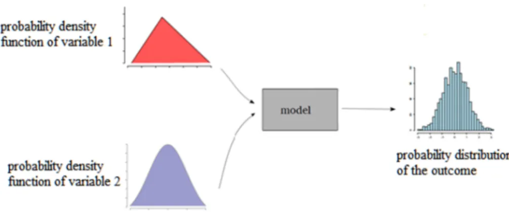
2.14 Simulation technique and uncertainty analysis ...44
2.15 Résumé du chapitre 2 ...45
CHAPTER 3 ... 46
Research Methodology and Model Development ... 46
3.1.1 Meticulous literature review ... 46
3.1.2 Risk analysis ... 47
3.1.3 Utility function and optimization ... 48
3.1.4 Numerical results ... 48
3.2 Developing deterministic model ...48
3.2.1 Generating optimal layout of construction site (phase 1) ... 49
3.2.1.1 Site and facility representation ... 49
3.2.1.2 Hazard and vulnerability interaction matrix ... 50
3.2.1.2.1 Modeling hazard interaction matrix ... 51
3.2.1.2.2 Modeling vulnerability interaction matrix ... 54
3.2.1.3 Optimization technique (evolutionary algorithm) ... 55
3.2.1.3.1 Utility function ... 56
3.2.1.3.2 Model layout constraints ... 57
3.2.1.4 Effect of space configuration (mean depth parameter) ... 60
3.2.1.5 Developing spatial risk map utilizing GIS ... 61
3.2.2 Finding optimal paths (phase 2) ... 63
3.3 Developing a probabilistic model ...65
3.3.1 Hazard modeling ... 67
3.3.2 Physical vulnerability modeling ... 70
3.3.3 Risk modeling ... 73
3.3.4 Probabilistic model utility function ... 74
3.4 Spatial methods for model validation ...75
3.5 Résumé du chapitre 3 ...76
CHAPTER 4 ... 78
Model Implementation and Results Discussion ... 78
4.1.1 Case study description ... 78
4.1.2 Optimization process and discussion of results ... 80
4.1.2.1 Optimal layout result... 80
4.1.2.2 Optimal path result ... 86
4.2 Implementation of a probabilistic model ...89
4.3 Résumé du chapitre 4 ...94
CHAPTER 5 ... 95
Conclusion and Perspectives ... 95
5.1 Summary of the research and findings ...95
5.2 Conclusion ...97
5.3 Directions of future research ...99
5.4 Résumé du chapitre 5 ...100
Author’s publication and contribution list ...101
xiii
LIST OF FIGURES
Figure 2.1. Life cycle of construction project ... 11
Figure 2.2. General vulnerability curve ... 29
Figure 2.3. Example of interaction matrix ... 34
Figure 2.4. Illustration of the decision variable chromosomes. ... 39
Figure 2.5. Total path cost between two cells ... 42
Figure 2.6. GIS data layers (Source: GIS LOUNGE) ... 43
Figure 2.7. Uncertainty analysis modeling ... 45
Figure 3.1. Research modeling methodology ... 47
Figure 3.2. Deterministic model to generate optimal site layout and optimal paths for evacuation ... 50
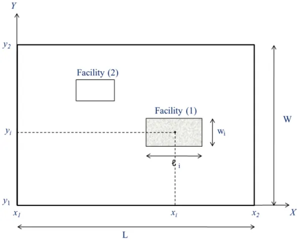
Figure 3.3. Representation of the construction site and facilities ... 51
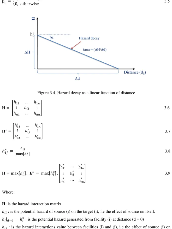
Figure 3.4. Hazard decay as a linear function of distance ... 53
Figure 3.5. Vulnerability as a linear function of hazard value ... 55
Figure 3.6. Decision variables chromosome ... 55
Figure 3.7. Illustration of the boundary constraint ... 58
Figure 3.8. Illustration of the overlapping constraint ... 59
Figure 3.9. Inverse distance weighted (IDW) interpolation process ... 63
Figure 3.10. Back-link convention ... 65
Figure 3.11. Probabilistic model to generate optimal site layout ... 67
Figure 3.12. Propagation of fire hazard ... 69
Figure 3.13. Hazard decay as normal distribution function ... 69
Figure 3.14. Damage curve functions ... 72
Figure 4.1. Layout of the optimal facility positions... 82
Figure 4.2. Map of site spatial variability of the potential global risk ... 83
Figure 4.3. Map of site mean depth ( ) ... 85
Figure 4.4. Map of spatial variability of risk within a site (risk amplification factor( )) ... 85
Figure 4.5. Determination of the exit gate position ... 86
Figure 4.6. Accumulated least risk dataset ... 87
Figure 4.7. Backlink risk dataset ... 88
xiv
Figure 4.9. Optimal facilities layout and their optimized coordinates [unit: meter] ... 92 Figure 4.10. Weibull distribution function and numerical results of probability failure of the site ... 93 Figure 4.11. Spatial fire risk map... 94
xv
L
IST OF
T
ABLES
Table 2.1. Some of the temporary facilities utilized over construction phase ... 15
Table 2.2. Example of interaction scale measurements categories (Hazard interaction scale) .... 34
Table 2.3. Implementation of mathematical operations on (4 x4) interaction matrix ... 35
Table 3.1. Categories of fire hazard intensity ... 68
Table 4.1. Facility dimensions, description, and categorization (fixed or movable), ... 79
Table 4.2. Maximum hazard intensity from each facility ... 80
Table 4.3. Coordinates of each facility center ... 81
Table 4.4. Normalized potential global risk of the facilities ... 81
Table 4.5. Distances [m] between facilities. ... 81
Table 4.6. Non-normalized optimal interaction risk matrix. ... 82
Table 4.7. Comparison between least-cost path and straight shortest path ... 88
Table 4.8. Facilities’ description and characteristics ... 90 Table 4.9. Expected probability of failure for each facility and for the whole construction site . 92
1
CHAPTER 1
General Introduction
This chapter involves presenting general introduction about construction site layout planning; the statement of the problem, justifications and objectives of conducting this research, the significance of this study, and finally the research outline.
1.1 Background
At the beginning of the twentieth century, a lot of the changes and evolutions happened in the construction industry. It becomes a fundamental criterion to measure countries’ growth and development. Consequently, a lot of money were spent and will be spent in this sector to construct many projects; highways, tunnels, bridges, schools, hospitals, water networks, and sewer treatment systems, for instance.
Unfortunately, the construction industry is distinguished from other industries by a lot of risks occurring during the execution of construction projects (Zhang et al. 2013). Moreover, one main feature of the construction industry is the frequent occurrence of uncertain extreme events, such as fire, explosion, blast waves, thermal flux, and leakage of hazardous material. They may lead to failure and/or adverse effect on the project schedule, project budget, and project quality. They also threaten lives of workers. Furthermore, they may lead to catastrophic consequences if they propagate from one area to another within a construction site.
Teo et al. (2005) and Tam et al. (2004) indicated that fire hazard is one kind of accidents that may occur at construction sites that may lead to construction schedule disturbance. Hui et al. (2012) designated that due to rapid development in the construction industries, the fire hazard is frequently occurring at construction sites. U.S. Fire Administration (2001) found that about
2
4,800 construction site fires occur every year, resulting in more than $ 35 million losses in property. It is obvious from these data; there is an urgent need to adopt creative ways to minimize these losses. Site layout planning, for instance, is one of these options that can be used for this purpose.
Construction managers and project site planners always aim to keep the consequences of these accidents events to a minimum level, and usually, they exert considerable effort to minimize injuries and fatalities that might be caused by these events. Therefore, it is necessary for the construction managers and project site planners to properly manage a construction site in order to maintain the integrity of the site, provide a safe working environment, and facilitate the evacuation process during the emergency cases. All of these will be positively reflected in workers’ morale and productivity (Huang and Wong 2015).
In fact, construction site contains several supporting temporary facilities (concrete plant, tower crane, materials storage area, fabrication lot, electrical generator, fuel storage, offices, and so on). These supporting facilities are necessary to execute and complete construction activities. In addition, these facilities must be accommodated in a proper position within a site to be helpful in minimizing consequences of the potential hazard and achieve project intents.
Actually, minimizing risk resulting from natural or technological hazards is still a scientific challenge. Referring to El-Rayes and Said (2009) the construction site space is considered as one of the project resources that require management, like any other resources, in order to accomplish the project objectives.
Site layout planning can be defined as the accommodation of supporting temporary facilities at a suitable location within the available site space. Hence, to consider a site layout plan as efficient, it is essential to benefit from the work areas provided to minimize hazard consequences and alleviate the catastrophic cascading effects. Zolfagharian and Irizarry (2014) stated that for each construction project, the site layout planning is distinctive from any other projects and depends entirely on the work areas and the location of different facilities.
According to that, this research aims to enhance site layout planning by developing new models that generate optimal site layout aims to minimize the catastrophic consequences of the potential hazard. Moreover, this research seeks identification of the shortest and safest paths to help evacuate the construction site quickly and safely during the occurrence of uncertain accidental
3
events. The advanced technology like; genetic algorithms (GA) and geographic information system (GIS) were used in this study to run optimization technique and to generate a site spatial risk map respectively.
1.2 Statement of the problem
Planning a construction site is a multi-objective task. In fact, it is very rare to complete a construction project without accidents. In addition, construction projects are not exempt from exposure to the occurrence of natural or technological hazards (fire, thermal flux, and explosions, for instance) that may lead to catastrophic consequences. The use of hazardous materials and the use of advanced technology in performing construction (production) activities are the main sources of these hazards’ occurrence. Fire hazard, for instance, may occur in one or more of the temporary supporting facilities assigned in a construction site. It may lead to damage construction site completely or partly. Whatever the damage level occurs, the work in the site will be suspended.
The current site layout planning models focus entirely on reducing the travel cost distance between facilities (El-Rayes and Khalafallah 2005). They ignored the potential hazards that may lead to infeasible or non-effectual solutions. They believe that minimizing the travel distance will help save time and money. This is not always true, because sometimes if the site layout is organized by focusing only on travel distance and the potential occurrence of fire hazard is overlooked, this may lead to the occurrence of fatal accidents. This may, in turn, lead to the suspension of work for a period of time, impacts on workers’ morale, and finally and more crucially, difficulties in evacuating the construction site. In addition to this, the parties involved in construction tend to make decisions regarding site layout plans based on their own experience. Sometimes these decisions may be incomplete and/or incorrect, which in turn leads to unsafe site layouts. Even though there are numerous researchers dealing with site space management to smooth arrangement of conducting construction activities, some of the construction site managers and planners still give less attention to site space management which still relies on the concept "first come first serve".
Moreover, only a few efforts have been devoted to organizing site layout for avoiding or at least minimizing the risk of potential hazards. El-Rayes and Khalafallah (2005); Sanad et al. (2008)
4
developed an optimization site layout model which aims to maximize construction safety. However, these models did not take into account the potential hazards such as fire and blast waves during optimization as they rather focus on the facilities containing hazardous materials. Furthermore, one of the most important issues that are often overlooked during site planning is the identification of the shortest and safest path to help evacuate the construction site quickly and safely during the occurrence of uncertain events. Evacuation is highly significant in construction site safety planning. If any hazard occurs within a site, the workers need to be evacuated safely, through crossing areas with least risk, to minimize casualties. According to Mahdjoubi and Yang (2001), finding the best paths can minimize the number of injuries and fatalities. Soltani et al. (2002) stated that the best route does not necessarily have to be the shortest distance path but must be the one with the lowest risk. The travel cost of moving along the shortest physical distance route within a construction site can be higher than that for other routes if there are limited visibility and a high risk along that route.
Therefore, this research aims to develop optimal site layout based on minimizing the risk of potential hazard. In addition, it aims to find the best paths to facilitate evacuation within a construction site, readily and without panic, from any position on the site to the external exit safe gate.
1.3 Research justifications
The site layout planning is one of the major tasks that should be performed by site managers and it is distinctive from one project to another. Most of the current site layout planning methods are ineffective because they primarily emphasized only on minimizing travel cost distance among facilities. In addition, they disregarded the expected risk of fire hazard. Moreover, construction site managers and planners give less attention to site space management due to complexity, great effort and time needed. Also, the rules and regulations for site layout planning have not been created. Also, there is a scarcity of studies aimed at identifying the lowest risk path for evacuating a construction site during emergencies.
Generally, implementing inefficient site layouts result in generating unsafe working environments, damage one or more of supporting facilities, project performance becomes poor, owner attitudes will not be met, price changes and cost overruns, and delay in project completion
5
date. These, in turn, lead to failure of the whole project. The present research addresses two main issues:
• The loss of life as a result of construction accidents every year should be reduced. According to (Banaitiene and Banaitis, 2012), about 1300 people are being killed every year in Europe due to construction accidents. Furthermore, construction workers are about three times more likely to be killed and twice as likely to be injured compared to other industries.
• The hazards such as fire may take place at any facilities on a construction site. It can then disseminate to other facilities or positions within the site, causing what is called domino-effect phenomena, which lead to catastrophic damages and losses in property and life. Even though this rarely happens in construction sites, the high dependence on advanced technology, which depends highly on electrical and fuel energy usage, may increase the probability of technological hazards occurrence. It is then worth to consider technological and natural hazard as one of other usual hazards happened during construction of the project. Since few efforts have been devoted to considering the impact of natural and technological hazards and their risks on construction sites, the current research is conducted to improve site layout planning in order to alleviate most of the problems associated with ineffective site layout plan.
1.4 Research objectives
This research aims to improve construction site layout planning in order to avoid or at least minimize the natural or technological hazard consequences during constructability process. Therefore, the objectives of this research can be summarized as follows:
1. Developing a new model that takes into account the hazard and vulnerability interactions among facilities. The model capable of avoiding, or at least diminishing the risk of natural or technological hazard and subsequent disasters.
2. Analyzing and identifying the influence of space configurations on spatial variability of risk within a construction site.
3. Visualizing the site spatial risk map (generated from potential hazards) within a construction site utilizing geographic information system (GIS).
6
4. Finding the best paths to facilitate evacuation within a construction site, readily and without panic, from any position on the site to the external exit safe gate. This will minimize the number of injuries and fatalities.
5. Developing a probabilistic optimization model aims to minimize the risk of failure of the whole site.
1.5 Significance of study
Indeed, performing efficient site layout planning considering the risk of natural or technological hazards will afford optimum safe working environments and minimize undesirable impacts of these hazards. In addition, construction companies that conducting site layout planning efficiently will benefit from greater productivity, financial savings, enhanced decision making and success rates of new projects. So, it is important to properly manage a site in order to minimize the number of accidents and injuries and maintain the integrity of the construction workers before, after and during emergency cases.
Foremost, this research draws inspiration from Dagan and Issac (2015) where the interaction between facilities is considered as a source of the hazardous situation within a construction site. However, up to now, only a few studies have been devoted to the generation of efficient models for site layout planning. The proposed model in this research overcomes the deficiencies of the existing optimization models, as the layout optimization now depends on the hazard and the vulnerability of the facilities, instead of transportation cost. The present research will focus on: 1. The implementing of an interaction matrix technique to determine the potential global impact
for each construction facility in the project.
2. The use of an optimization technique to optimize site layout facilities based on interaction matrices
3. The effect of space configuration in understanding, accommodating and modeling spatial analysis problems.
4. The use of geographic information system (GIS) capabilities to analyze spatial datasets and generate a site spatial risk map for the construction site. It will assist in identifying the most at-risk positions within the site, which will play a primary role in finding the safest paths for site evacuation to minimize injuries and fatalities. Generally, understanding and visualizing
7
the spatial variability of risk at the construction site will assist site managers in making and adopting proper decisions. This will be able to avoid or at least reduce the domino effect of a threat.
5. Develop a probabilistic model that consider the risk of failure of the whole site is a combined of individual failure of each facility presents in the construction site. It shows how optimizing site layout reduces the probability of failure for the whole site.
The proposed model will assist construction managers and planners in the hierarchy the existing facilities in the construction site based on their potential global impact. This hierarchy will lead to determining the facilities that required more attention (highest risk facilities) during the construction phase to enhance the constructability and safety of workspaces in the project site. Moreover, the risk is visualized within a construction site by considering the space configuration and visibility in estimating the risk at each position within a site
1.6 Thesis organization and contribution
Since the current site layout planning models focus only on travel cost distance, therefore, in this study, we are interested in developing site layout optimization model that takes into account the risk of natural or technological hazard within a construction site as the main utility function. Two models have been developed: deterministic and probabilistic. Both models consist of: (1) modeling construction site components, for instance; electric generator, fuel storage, offices, equipment and material storages, in the 2D layout. These components act as hazardous sources and potential targets at the same time; (2) modeling hazard interaction matrix: it shows the hazard interaction among site components and the attenuation of hazard with distance; (3) modeling vulnerability interaction matrix: it represents the potential weakness of whole targets to the hazard generated from each source; (4) defining the utility function: it aims to afford an optimized site layout with minimum total risk in the construction site; and (5) performing spatial analysis technique, utilizing space syntax principle, to realize space configurations in the construction site. As the evacuation process is considered in evaluating and visualizing the risk, the actual risk is amplified by utilizing penalty factor, took from space syntax analysis, called mean depth.
8
1. Chapter one: include an introduction to the study, the objective of the study, the reason behind performing this study, and the significance of it.
2. Chapter two: literature review that involves information about a current site layout planning methods, the criteria utilized for site layout planning, the optimization technique, the hazard, vulnerability and risk in a construction site, space syntax explanation, GIS capabilities, and Dijkstra’s and least cost path algorithm.
3. Chapter three: research methodology designates how the objectives of the study will be attained. Also, the model developments that display the mathematical formulas to formulate site layout planning problems and run optimization technique.
4. Chapter four: case studies that display the model implementation on a case project that consists of several facilities acting as hazardous sources and potential vulnerability targets at the same time. It involves discussion on the obtained results.
5. Chapter five: conclusion and perspective of the study.
1.7 Résumé du chapitre 1
Ce chapitre contient une introduction générale sur l’aménagement d’un chantier de construction, la problématique, l’importance ainsi que les objectifs de cette recherche.
En général, le secteur de la construction se distingue des autres secteurs par la présence des risques pendant le processus de la construction (Zhang et al. 2013). Une caractéristique principale en est la présence fréquente d’événements extrêmes incertains, comme le feu, l’explosion, les ondes de souffle, le flux thermique et la fuite de matériaux dangereux. Ces évènements pourraient jouer sur le calendrier d’un projet, sur son budget et sur sa qualité. Ils peuvent aussi mettre en danger la vie des ouvriers. En outre, ils peuvent mener à des conséquences catastrophiques s’ils se propagent d’une zone à une autre dans un chantier. Les chefs de projets de construction ont toujours comme objectif de minimiser les conséquences de ces événements accidentels et font un effort considérable pour réduire les blessures et les victimes sur les chantiers et pour faciliter le processus d’évacuation en cas d’urgence.
En fait, le chantier contient plusieurs installations provisoires nécessaires pour exécuter les travaux de construction. Elles doivent être situées dans une position appropriée afin de minimiser les conséquences du danger potentiel et de réaliser les objectifs du projet. Les modèles actuels de
9
planification des chantiers de construction se concentrent entièrement sur la réduction des coûts de déplacement entre les installations (El-Rayes and Khalafallah 2005). Ces modèles ne prennent pas en compte les aléas potentiels qui peuvent menacer les résultats attendus du projet.
Ils considèrent que la minimisation de la distance de déplacement aidera à économiser du temps et de l’argent. Ce n’est pas toujours vrai : si la disposition du chantier est organisée en prenant en compte seulement la distance des déplacements et en ignorant la présence potentielle des aléas naturels ou technologiques, elle peut mener à des accidents mortels. Ceci peut conduire à son tour à la suspension du travail pour une certaine période, à des impacts sur le moral des ouvriers et finalement à des difficultés dans l’avancement du chantier. De plus, les parties impliquées dans la construction ont tendance à prendre des décisions quant aux plans d’aménagement d’un chantier basés sur leur propre expérience. Certains chefs de projets de construction donnent peu d’attention à la gestion spatiale du site qui est toujours basée sur le concept « premier arrivé, premier servi ». Parfois, ces décisions peuvent être mauvaises et entrainent une disposition risquée du chantier.
Une autre question importante souvent oubliée pendant la planification du chantier est l’identification du chemin le plus court et le plus sûr pour évacuer le chantier rapidement et sans risque pendant la présence des aléas. Cette recherche vise à améliorer l’aménagement du chantier en développant des modèles capables de minimiser le risque de l’aléa potentiel. De plus, elle aide à trouver les meilleurs chemins pour faciliter l’évacuation sur un chantier, sans panique et à partir de n’importe quelle position sur le chantier. Cette recherche vise à étudier et à analyser l’influence de configurations spatiales sur la variabilité spatiale de risque dans un chantier. Le modèle proposé aidera les chefs de projets de construction dans l’identification des installations et des positions qui nécessitent plus d’attention (installations à haut risque) pendant la phase de construction, qui se traduira par l’amélioration de la constructibilité et de la sécurité des espaces de travail sur le site du projet.
Cette recherche sera présentée dans cinq chapitres comme illustré ci-dessous :
1. Chapitre un : il contient une introduction générale de la thèse, les objectifs, l’importance de la réalisation de cette recherche.
2. Chapitre deux : il présente une étude bibliographique concernant les modèles actuels pour l’aménagement des chantiers, les données générales sur l’aléa, la vulnérabilité, le risque, la
10
matrice d’interaction, les capacités des SIG, l’implémentation de l’algorithme de Dijkastra, l’impact de la configuration de l’espace sur le risque et la façon dont la technique d’analyse spatiale est appropriée pour cela, le mécanisme de travail de l’algorithme d’évolution de l’optimisation et finalement le principe d’analyse de l’incertitude.
3. Chapitre trois : il traite la méthodologie adoptée pour réaliser les objectifs de la thèse. Il illustre les étapes nécessaires pour développer deux modèles d’aménagement de chantier (déterministe et probabiliste). Il présente les formules mathématiques utilisées pour réaliser la modélisation de l’aléa, de la vulnérabilité et du risque, nécessaire pour développer des modèles d’aménagement de chantier. Il démontre la procédure adoptée pour générer une carte de risque spatial et pour déterminer les chemins optimaux à partir de n’importe quelle position jusqu’à la sortie de secours sécurisée extérieure.
4. Chapitre quatre : il décrit le cas pratique utilisé pour mettre en œuvre les modèles proposés. Il contient des commentaires et l’analyse des résultats obtenus.
5. Chapitre cinq : il contient un résumé de la recherche, il présente une conclusion de la thèse, et fournit des perspectives pour les développements futurs de la recherche en cours.
CHAPTER 2
Related
This chapter involves presenting
layout planning, interaction matrix, kind studies conducted and dealt with a space syntax principle,
benefit of
2.1 Project life cycle
Project life cycle can be defined as plant or
start and end point
defined as a set of activities linked together to form a task and various phases called project life cycle.
The life cycle of a
participating in the project in order to accomplish owner desires, The life cycle of construction project
having experience in construction industry. Figure 2.1 displays all of these phases.
CHAPTER 2
Related Work
This chapter involves presenting
layout planning, interaction matrix, kind studies conducted and dealt with a space syntax principle,
benefit of simulation
Project life cycle
life cycle can be defined as or another specified result start and end points
defined as a set of activities linked together to form a task and various phases called project life cycle.
life cycle of a
participating in the project in order to accomplish owner desires, The life cycle of construction project
having experience in construction industry. Figure 2.1 displays all of these phases.
CHAPTER 2
ork
This chapter involves presenting
layout planning, interaction matrix, kind studies conducted and dealt with a
space syntax principle, Dijkstra’s algorithm, GIS dat simulation for risk analysis.
Project life cycle
life cycle can be defined as other specified result
accompanying
defined as a set of activities linked together to form a task and various phases called project life cycle.
life cycle of a construction project involves exerting many efforts from all parties participating in the project in order to accomplish owner desires,
The life cycle of construction project
having experience in construction industry. Figure 2.1 displays all of these phases.
Figure
This chapter involves presenting general information about
layout planning, interaction matrix, kinds of hazards, vulnerability definition and types, studies conducted and dealt with a site layout planning
Dijkstra’s algorithm, GIS dat for risk analysis.
life cycle can be defined as “the whole process other specified result” Archibald
accompanying with a time scale
defined as a set of activities linked together to form a task and various phases called project life cycle.
construction project involves exerting many efforts from all parties participating in the project in order to accomplish owner desires,
The life cycle of construction project consist
having experience in construction industry. Figure 2.1 displays all of these phases.
Figure 2.1. Life cycle
11
general information about
of hazards, vulnerability definition and types, site layout planning
Dijkstra’s algorithm, GIS datasets analysis and capabilities, and the
“the whole process needed
d (2003). The life cycle for any kind of project has with a time scale. Moreover, the construction project can be defined as a set of activities linked together to form a task and
construction project involves exerting many efforts from all parties participating in the project in order to accomplish owner desires,
consists of several phases that are common to anyone having experience in construction industry. Figure 2.1 displays all of these phases.
ife cycle of construction project
general information about life cycle of construction project, of hazards, vulnerability definition and types, site layout planning, optimization technique explanati
asets analysis and capabilities, and the
needed for producing a new system The life cycle for any kind of project has
Moreover, the construction project can be defined as a set of activities linked together to form a task and get a specific product through
construction project involves exerting many efforts from all parties participating in the project in order to accomplish owner desires,
of several phases that are common to anyone having experience in construction industry. Figure 2.1 displays all of these phases.
of construction project
life cycle of construction project, of hazards, vulnerability definition and types,
optimization technique explanati asets analysis and capabilities, and the
for producing a new system The life cycle for any kind of project has
Moreover, the construction project can be get a specific product through
construction project involves exerting many efforts from all parties participating in the project in order to accomplish owner desires, purposes, and requirements. of several phases that are common to anyone having experience in construction industry. Figure 2.1 displays all of these phases.
of construction project
life cycle of construction project, of hazards, vulnerability definition and types, previous
optimization technique explanati asets analysis and capabilities, and the
for producing a new system, new The life cycle for any kind of project has Moreover, the construction project can be get a specific product through
construction project involves exerting many efforts from all parties and requirements. of several phases that are common to anyone having experience in construction industry. Figure 2.1 displays all of these phases.
life cycle of construction project, site previous optimization technique explanation, asets analysis and capabilities, and the
, new The life cycle for any kind of project has Moreover, the construction project can be get a specific product through
construction project involves exerting many efforts from all parties and requirements. of several phases that are common to anyone
12
2.1.1 Feasibility study
In this phase, most of the analysis and assessments have been done by the owner or occasionally with the involvement of consultants. The parties participated, in this phase; conduct the feasibility study of proposed constructing project, evaluate the economic feasibility of the project assess the scope of the work, determining the suitable location of the project from possible available options, and perform environmental and social impact assessment of the project.
2.1.2 Design phase
Design phase can be separated into two sub-phases: preliminary design and detailed design. The initial design of the project is made during a preliminary design stage. It also involves: evaluating different alternatives, preparing preliminary plans, drawings, specifications, preparing preliminary cost estimates, and preliminary landscape of the project that will be evaluated by the owner before generating detailed drawings. The preliminary design stage needs a significant coordination and cooperation among different specialists in geology, civil, architecture, electric, and mechanic works.
On the other hand, the detailed design stage involves: investigation and design of project items, refining the preliminary design, developing detailed plans and specifications, doing cost estimates, and determining construction materials and construction methods, and finally identifying the required temporary supporting facilities and equipment.
2.1.3 Procurement phase
The construction documents prepared during design phase are assembled together in order to start procurement phase. The procurement phase involves: conducting a bid advertisement to attract contractors to bid, provide contractors with bid documents, conduct meetings with interested bidders, and evaluating the interested contractors to select one of them to construct the project.
13
2.1.4 Construction phase
The construction phase is the most important and vital phase of a project life cycle since the plans and specification will be translated into a physical product. Most of the construction problems will appear during this phase. In addition, most of the project budget will be spent on this phase. Therefore, the selected contractor will exert all of his efforts to minimize accidents, injuries, fatalities and provide a safe working environment to achieve and complete project within specified time, budget, and quality. Site layout planning is one of the essential tasks that must be conducted during this phase.
2.1.5 Operation and maintenance phase
In this phase, the constructed project is evaluated to determine if it meets the planned objectives or not. This phase involves the operation and maintenance of the constructed project. in addition, it involves transferring the responsibility of project operation to the initial occupants.
2.2 Site layout planning
Site layout planning techniques perform to all projects where numerous physical means have to be located in a certain space. In general, the layout means an arrangement of everything required to complete production of any product. Really, the main purpose of site layout planning involves organizing work areas in the most efficient manners to be safe for personnel carrying out the work.
Site layout planning can be defined as accommodation, in advance, of supporting temporary facilities, such as an electric generator, fuel storage, office trailers, fabrication areas, construction equipment, and warehouses and so on, at the proper location within the available site space. Even though all of these facilities are temporary, but they are great crucial to conduct and complete construction and production activities. In addition, any accidental event occurs in at least one of these facilities may be sufficient to endanger the workers’ life, escalate the occurrence of domino effect phenomenon, hinder and suspend work in the project for a period of time and even failure of the whole project. The purposes of conducting site layout planning allow a more active
14
workflow at the site and make workers and equipment being more productive. Andayesh and Sadeghpour (2014) indicated that site layout models can be categorized into two classes. One is the static model, i.e. changes over time are not considered. The other is the dynamic model, i.e. changes over time are considered. The dynamic models focus on assigning an appropriate location of each temporary facility taking into account the dynamic changes in the requirements and site space availability. Huang and Wong (2015) stated that the site layout planning should be optimized taking into account multiple construction stages to avoid the excessive cost associated with the relocation of facilities and enhance efficiency.
The available construction site space should be exploited efficiently in order to minimize threats’ impacts, provide the safe working environment, and enhance workers’ productivity. There are many shortcomings associated with ineffective site layout plans:
1. Bad use of the available space.
2. Move long distances to carry out any operations on a construction site. 3. Skilled and qualified labors perform a lot of simple works.
4. The occurrence of various accidents on the site. 5. Suspension of work for a period of times.
6. The discomfort of labor when executing construction activities.
7. The complexity of monitoring and controlling the construction process
However, there is a consensus among most researchers that site layout planning is still a complex and challenging task (Zolfagharian and Irizarry 2014; Sanad et al. 2008; Zouein and Tommelein 1999). Sanad et al. (2008) indicated that site layout planning is a complex problem, due to the existence of several large tasks that need to be performed. Zouein and Tommelein (1999)
demonstrated that utilizing site space efficiently to locate resources and facilities over the duration of a project is a complicated dilemma. In general, to develop and attain an efficient site layout plans, the construction managers and site planners must recognize the followings:
1. The facilities needed to be located on a construction site
2. The available space and the size of the space required for each facility.
3. The best position that each facility should be located at within a construction site 4. The reduction of failure risk due to natural or technological hazards.
5. The increase in workers’ satisfaction and safety. 6. The reduction of material handling
15
7. The reduction of travel distance and unnecessary movements to minimize total transportation cost.
Unfortunately, all of these realizations cannot be achieved simultaneously, so the final site layout should take into account a balance among all factors affecting on it in order to acquire optimal site layout plan. Up until now, there is no regulation adopted to organize and manage site layout planning for avoiding or at least minimizing the risk of natural and/or technological hazards. Furthermore, the current site layout planning models consider a travel distance as a sole criterion in generating site layout plans (El-Rayes and Khalafallah 2005). Therefore, it is significant to develop a new model aims to minimize the risk of natural and/or technological hazard.
2.3 Temporary facilities
Construction managers, based on their experience, have to identify the temporary facilities required to facilitate construction operations. Table 2.1 displays some of the common temporary facilities utilized over construction phase of the project. According to Elbeltagi et al. (2001), the size of temporary facilities can be determined according to estimated quantity of the work, site space availability, resources’ production rate, labors requirements, and the allocated project budget considerations.
Table 2.1. Some of the temporary facilities utilized over construction phase
Temporary Facility 1 Labor services 2 Carpentry fabrication 3 Carpentry storage 4 Material storage 5 Offices 6 Parking lots 7 Concrete plant 8 Guard office 9 Electric generator 10 Fuel storage
11 Steel reinforcement rebar shop 12 Reinforcement rebar fabrication area 13 Cement storage
14 Welding area
16
2.4 Optimal path
Occasionally, construction managers encounter difficulties in finding the safest routes for movement within a construction site. The ability to find the optimal path between two points is very important in all fields of life: in industry, commerce, urban planning, and evacuation, for instance. It has great importance in reducing cost, speeding up production, and facilitating communication.
Unfortunately, there is a scarcity of studies aimed at identifying the lowest risk path for evacuating a construction site during emergencies. Soltani et al. (2002) stated that the best route does not necessarily have to be the shortest distance path but must be the one with the lowest risk.
The optimal distance and the straight line distance between any two points are not necessarily the same. The straight line distance always overlooks the existence of obstacles, the cost of route construction, the time needed to navigate along the route, and the riskiness of the route. On the other hand, optimal path analysis leads to finding the most effective and shortest path from one location to another, considering all of these criteria and/or any other criteria defined by the planners and construction managers.
The travel cost of moving along the shortest physical distance route within a construction site can be higher than that for other routes if there are limited visibility and a high risk along that route. Therefore, finding the best paths that facilitate evacuation within a construction site, without panic, from any position on the site to the external exit safe gate is one of the crucial issues that haunt construction site managers.
2.5 Previous studies
Several studies have been conducted for construction site layout planning and to find optimal paths. Zolfagharian and Irizarry (2014) confirmed that site planning is unique for each construction project. They also stated that optimizing the cost, safety, and productivity of a project relies on the adequate planning of the construction site layout.
Really, based on the broad literature review, the studies interested in site management and planning can be categorized into three parts: (1) the criteria that have been utilized for
17
conducting optimization; (2) optimal path determination; and (3) risk analysis and quantification studies.
2.5.1 Criteria consideration for site layout planning
Site layout planning can be categorized according to the criteria that have been utilized for conducting optimization into:
2.5.1.1 Optimization models based on travel cost distance
In general, there are a lot of efforts have been exerted by the researchers to enhance construction site layout planning. Most of these efforts consider the travel cost distance as the most significant utility function and they aim to minimize it (Andayesh and Sadeghpour 2013, 2014; Astour and Franz 2014; Cheng and O’Connor 1994, 1996; Hegazy and Elbeltagi 1999; Zouein et al. 2002; Said and El-Rayes 2013; Zouein and Tommelein 1999; Huang and Wong 2015). They also applied several optimization algorithms to accommodate construction facilities at suitable positions within a construction site.
Hegazy and Elbeltagi (1999) developed an evolution-based site layout planning model called EvoSite. It is based on the implementation of a genetic algorithm (GA) to search for the optimum layout. El-Rayes and Said (2009) presented a model based on approximate dynamic programming (ADP) aiming to minimize the overall site layout costs in order to get optimal dynamic site layout of construction projects. Zouein and Tommelein (1999) developed a linear programming model to generate dynamic site layout, endeavoring to minimize the travel distance and relocation costs among all facilities. Andayesh and Sadeghpour (2013) developed an innovative dynamic model that is capable of producing optimized layouts over the project’s duration. The model is derived from the principles of an energy dominating physical system. The model is effectual due to its ability to assign space to facilities when they are required on the site and allows for the reuse of the space over time. Huang and Wong (2015) used the branch and bound algorithm to develop optimal site layout aims to minimize total cost. They indicated that the total cost consist of material transportation cost between facilities, set up cost of facilities and relocation cost for all facilities in each construction stage.
18
Furthermore, several researchers have used advanced technologies for site management. Cheng and O'Connor (1994, 1996) developed an automated site layout system called ArcSite. The proposed model uses the search by elimination principle available in the geographic information system (GIS) to identify the best position for each supporting temporary facility and generate the optimal layout. Andoh et al. (2012) presented a framework for the continuous tracking of the 4D status of a dynamic construction site, utilizing radio frequency identification (RFID), the global positioning system (GPS) and the GIS, in order to achieve project objectives. Astour and Franz (2014) described the problems associated with site layout planning and developed a model utilizing building information modeling (BIM) to generate a 3D site layout plan. Kang and Seo (2012) utilized GIS for determining the optimal layout of a haul route for large earthmoving projects.
2.5.1.2 Optimization models for consideration of safety issues
Other researchers concerned with maximizing safety conditions by considering the safety operation of some supporting facilities, crane, and facilities containing hazardous material for instance. They asked construction managers to give them higher priority of controlling over construction phase (Elbeltagi and Hegazy 2003; El-Rayes and Khalafallah 2005; Sanad et al. 2008; Dagan and Isac 2015).
Elbeltagi and Hegazy (2003) proposed site layout planning optimization model that considers other relevant criteria, in addition to the travel distance, such as site safety and productivity. They presented the construction site and facilities as a multi-unit. The GA was used to achieve an optimal site layout. Sanad et al. (2008) developed an optimization site layout model by utilizing a GA and considering safety aspects and the actual route between facilities as the main criteria in generating optimal site layout. El-Rayes and Khalafallah (2005) presented a model capable of maximizing construction site safety and minimizing travel cost distance within a construction site. They suggested providing an adequate distance between hazardous facilities and any other potential targets. The safety criteria that were considered in this model are (1) crane safety operation and (2) control of hazardous materials. Although the model did not take into account hazards from all other construction facilities, but it is still vital because it illustrated the trade-off between safety and travel costs. Dagan and Isaac (2015) proposed a planning method in order to protect workers from injuries and keep them at a safe distance from each
19
other. The proposed method depends on the assumption that the hazardous situation is a result of the interaction between the reinforcing and counteracting characteristics of the workers. Moreover, they embedded the definition of a minimum safe distance between workers. In addition, 3D time-space diagram is embraced in the methodology to analyze the dynamic movement of workers on the construction site.
2.5.2 Determining the optimal path
Finding the safest routes for movement within a construction site is also still a scientific challenge. Soltani and Fernando (2004) developed a framework for construction site path planning analysis, considering travel cost, visibility, and safety as multi-criteria for path evaluation. Choi et al. (2009) developed software called (dump traveler) to determine the optimal haulage routes from mines for dump trucks. The software is based on a combination of multi-criteria evaluation and least-cost path analysis. Choi and Nieto (2011) created a software application called the Google Earth Based Optimal Haulage Routing System (GEOHARTS) to find the optimal route for dump trucks in construction and mining sites. It is based on the capability of Google Earth and the least-cost path algorithm. Moreover, the software has the ability to generate the optimal haulage routes that ensure the shortest travel time and lowest fuel cost between loading and dumping areas.
There is a frequent trend among most researchers to use GA to find the optimal path. las Mercedes Gómez-Albarrán et al. (1997) created an algorithm called GALO, which integrated GA and Lee’s algorithm in order to find the shortest path between nodes in circuit routing. Gen et al. (2001) utilized GA for solving problems associated with network analysis, especially those related to finding the shortest path. Soltani et al. (2002) conducted a comparison among three optimization techniques to evaluate their efficiency in finding the optimal paths on construction sites. These algorithms are GA, Dijkstra’s algorithm, and the A* algorithm. Saha et al. (2005)
utilized Dijkstra’s algorithm and least-cost path analysis in route planning of areas susceptible to landslide. Xu and Lathrop (1994) improved the cost simulation model. They enhanced the cost-path tracking by recording cost-path information using two layers. Feldman et al. (1995) used remotely sensed data, GIS, and least-cost analysis to carry out pipeline routing.