HAL Id: hal-00298859
https://hal.archives-ouvertes.fr/hal-00298859
Submitted on 9 Jul 2007HAL is a multi-disciplinary open access
archive for the deposit and dissemination of sci-entific research documents, whether they are pub-lished or not. The documents may come from teaching and research institutions in France or abroad, or from public or private research centers.
L’archive ouverte pluridisciplinaire HAL, est destinée au dépôt et à la diffusion de documents scientifiques de niveau recherche, publiés ou non, émanant des établissements d’enseignement et de recherche français ou étrangers, des laboratoires publics ou privés.
Rapid channel incision of the lower Pearl River (China)
since the 1990s
X. X. Lu, S. R. Zhang, S. P. Xie, P. K. Ma
To cite this version:
X. X. Lu, S. R. Zhang, S. P. Xie, P. K. Ma. Rapid channel incision of the lower Pearl River (China) since the 1990s. Hydrology and Earth System Sciences Discussions, European Geosciences Union, 2007, 4 (4), pp.2205-2227. �hal-00298859�
HESSD
4, 2205–2227, 2007
Channel incision of the lower Pearl River
(China) X. X. Lu et al. Title Page Abstract Introduction Conclusions References Tables Figures ◭ ◮ ◭ ◮ Back Close
Full Screen / Esc
Printer-friendly Version Interactive Discussion
EGU
Hydrol. Earth Syst. Sci. Discuss., 4, 2205–2227, 2007 www.hydrol-earth-syst-sci-discuss.net/4/2205/2007/ © Author(s) 2007. This work is licensed
under a Creative Commons License.
Hydrology and Earth System Sciences Discussions
Papers published in Hydrology and Earth System Sciences Discussions are under open-access review for the journal Hydrology and Earth System Sciences
Rapid channel incision of the lower Pearl
River (China) since the 1990s
X. X. Lu1, S. R. Zhang1, S. P. Xie2, and P. K. Ma2
1
Department of Geography, National University of Singapore, 119260, Singapore
2
Zhaoqing Hydrological Bureau of Guangdong Province, Zhaoqing 526060, Guangdong, China
Received: 27 June 2007 – Accepted: 2 July 2007 – Published: 9 July 2007 Correspondence to: X. X. Lu ([email protected])
HESSD
4, 2205–2227, 2007
Channel incision of the lower Pearl River
(China) X. X. Lu et al. Title Page Abstract Introduction Conclusions References Tables Figures ◭ ◮ ◭ ◮ Back Close
Full Screen / Esc
Printer-friendly Version Interactive Discussion
EGU Abstract
This paper reported a dramatic channel incision (>10 m in the deepest cut) during the past 10 years or so in the lower Pearl River, the second largest river in terms of water discharge in China. The channel incision had caused changes both in the channel geometry as well as in the river hydraulics. Also, the water exchange between the
5
two major tributaries of the Pearl River, the Xijiang and Beijing, had been significantly changed due to the channel incision. The rapid channel incision was principally the result of extensive sand mining in the lower Pearl River and the delta region due to the booming economy in the Pearl Delta region. Slight increase of water discharge and significant decrease of sediment load since the early 1990s in both the Xijiang and
10
Beijiang also likely contributed to the observed dramatic river bed donwcutting to some extent. This has important implications for river management, as the large Chinese rivers have seen a dramatic depletion of sediment fluxes due to the combined effects of declining rainfall, dam constructions, water diversion, reforestation and afforestation, and sediment mining over the recent decades.
15
1 Introduction
Hydro-climatic fluctuations and disturbances of human activities over the past decades or even centuries resulted in deposition or erosion of alluvial or fluvial river beds and other forms of river channel changes. Channel incision of a fluvial river as a result of sediment depletion has a series of detrimental effects, such as groundwater table
20
lowering, flood flow increase, the destabilization of infrastructures (e.g. bridges, and dykes), sea water encroachment in the coast regions, disruptions to in-stream biolog-ical communities and several other biologbiolog-ical and environmental impacts (Bravard et al., 1997; Rinaldi et al., 2005). It is noticed that human activities can sometimes in-duce channel change more significantly than those by natural events such as floods,
25
ex-HESSD
4, 2205–2227, 2007
Channel incision of the lower Pearl River
(China) X. X. Lu et al. Title Page Abstract Introduction Conclusions References Tables Figures ◭ ◮ ◭ ◮ Back Close
Full Screen / Esc
Printer-friendly Version Interactive Discussion
EGU
ample, effects of sediment mining on alluvial river incision have been huge (Rinaldi et al., 2005). This has been well documented for the rivers in California (Harvey and Shumm, 1987; Collins and Dunne, 1990; Kondolf and Swanson, 1993; Kondolf, 1994; Kondolf, 1997; Sandecki and Avila, 1997), Washington (Collins and Dunne, 1989), Italy (Surian and Rinaldi, 2003; Rinaldi and Simon, 1998; Rinaldi, 2003), Spain (Rovira et
5
al., 2005), France (Peiry, 1987; Petit et al., 1996; Bravard et al., 1999; Gaillot and Pi ´egay, 1999; Arnaud-Fassetta, 2003), UK (Sear and Archer, 1998), New Zealand (Page and Heerdegen, 1985) and Australia (Davis et al., 2000).
The large Chinese rivers have seen a dramatic depletion of sediment load during the past several decades. For example, the annual sediment discharge in the Yellow River
10
has declined from over 1000 MT as often cited in the literature (Milliman and Meade, 1983) to around 400 MT in the 1990s (Xu, 2003) and even below 200 MT in recent years (Wang et al., 2007). Similarly, the annual sediment flux in the Yangtze River has declined from >400 MT to <200 MT since the closure of the first stage of the Three Gorges Dam in 2003 for the Yangtze River (Chen et al., 2006; Yang et al., 2006; Yang
15
et al., 2007). Apart from the declining rainfall in North China (Xu, 2003), the construc-tion of the numerous reservoirs, water diversion and consumpconstruc-tion, reforestaconstruc-tion and afforestation, and sediment mining are primary reasons for such decline. For example, sediment mining has been increasingly important in reducing sediment load as a re-sult of the booming Chinese economy over the past three decades or so (Chen et al.,
20
2006). The annual in-channel sediment extraction was 40 MT in the 1980s and 80 MT in the 1990s in the lower Yangtze River (Chen et al., 2006). However, the detrimental effects as a result of such massive removal of sediment on the large Chinese rivers have rarely been reported.
This paper provided the river channel measurements made since the 1990s in the
25
lower Pearl River (a large fluvial river) to assess its rapid incision and consequent im-pacts on the channel geometry and river hydraulics. Also, possible contributing factors to the channel incision are to be presented and discussed. This is significantly impor-tant for channel management in large rivers because the previously documented rivers
HESSD
4, 2205–2227, 2007
Channel incision of the lower Pearl River
(China) X. X. Lu et al. Title Page Abstract Introduction Conclusions References Tables Figures ◭ ◮ ◭ ◮ Back Close
Full Screen / Esc
Printer-friendly Version Interactive Discussion
EGU
with channel incision are relatively smaller compared to the Pearl River in this study. For example, Po River in Italy has a drainage area of 70 091 km2, Nepean River in Australia 21 740 km2and Rhone River in France 20 300 km2, and the remaining <10 000 km2.
2 Study area
The Pearl River, with a drainage area of 453 700 km2 (442 100 km2 is located inside
5
China) is the second largest river in China with an annual water discharge of 336 billion m3(Fig. 1) (PRWRC, 1991). Its annual water discharge is less than the Yangtze River, but 5 times larger than the Yellow River. It extends from Yunnan Province in Southwest China to Guangdong Province before pouring into South China Sea (SCS) with a total length of 2214 km. The Pearl River system is composed of the three main rivers, Xijiang
10
(77.90% of the total basin area), Beijiang (10.30%) and Dongjiang (5.96%), and some small rivers draining the Pearl River Delta (5.84%) (Fig. 1). The Xijiang and Beijiang are connected by a small waterway called Shixianyao before they flow into the Pearl River Delta through their own courses.
The Pearl River basin consists of various source rocks from Precambrian
metamor-15
phic rocks to Quaternary fluvial sediments (Zhang et al., 2007b). Carbonates are widely distributed in the basin, accounting for 39% of the total basin area (PRWRC, 1991). The igneous rocks are dominated by granites with acid to intermediate compo-sition, covering about half of the area of Guangdong Province. Small area coverages of evaporites and pyrites are mainly scattered in the upperstream of the Xijiang in
Yun-20
nan and Guizhou provinces. Quaternary fluvial sediments are mostly developed in the lower alluvial plain, the delta plain and the interior river valley plain of Guangdong and Guangxi provinces.
HESSD
4, 2205–2227, 2007
Channel incision of the lower Pearl River
(China) X. X. Lu et al. Title Page Abstract Introduction Conclusions References Tables Figures ◭ ◮ ◭ ◮ Back Close
Full Screen / Esc
Printer-friendly Version Interactive Discussion
EGU
3 Methods and datasets
Annual channel cross-sections were measured at the three main hydrological stations (Gaoyao and Makou in the lower Xijiang, and Sanshui in the lower Beijiang) (Fig. 1). The equipments used for the measurements were depth sounder before 1999 and Acoustic Doppler Current Profiler (ADCP) after 1999. The measurements were
con-5
ducted at least once a year in general in the dry season ranging from November to April. The channel geometry changes at the three hydrological stations were investi-gated on the basis of the annual measurements over the 14 years from 1990 to 2003. In addition to the 3 main cross-sections, there were 25 extra cross-section profiles ob-tained in the three years of 1992, 1999 and 2003 along the 50 km stretch from Gaoyao
10
and Makou in the lower Xijiang (Fig. 1). The 25 cross-sections were obtained using the navigation charts produced in 1992 and 1999, and the actual ADCP measurements in 2003. The thalweg lines were reconstructed from the 25 cross-sections for the three years to evaluate the longitudinal channel changes.
The influence of river channel incision on river hydraulics was evaluated by
compar-15
ing the stage-discharge curves from different years. Water levels attained at particular levels of flood water discharge at different years at Gaoyao station was compared to further reveal the water level lowering caused by river channel incision.
Annual water discharge and sediment flux data were obtained from the gauging sta-tion Gaoyao of the Xijiang, and Shijiao of the Beijiang. They were measured following
20
the related Chinese national standard (Ministry of Water Resources of China, 1992).
4 Results
4.1 Channel geometry change at three hydrological stations
All the three stations examined (Gaoyao and Makou in the Xijiang, Sanshui in the Bei-jing) experienced significant down cuts in the riverbed over the 14 years from 1990
HESSD
4, 2205–2227, 2007
Channel incision of the lower Pearl River
(China) X. X. Lu et al. Title Page Abstract Introduction Conclusions References Tables Figures ◭ ◮ ◭ ◮ Back Close
Full Screen / Esc
Printer-friendly Version Interactive Discussion
EGU
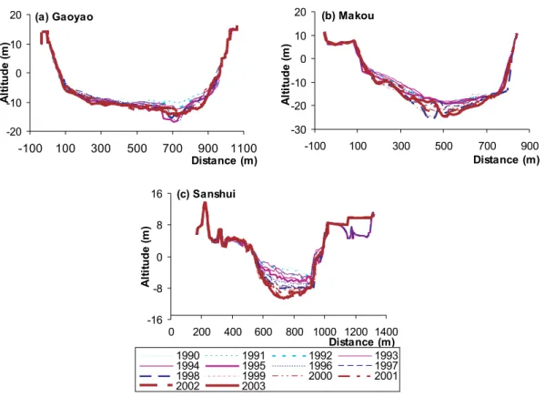
to 2003, especially after 1992 (Fig. 2). The deepest cut within the 14 years period was 6.3 m at Gaoyao in 1995, 5.8 m at Sanshui in 2003, and 7.1 m at Makou in 1998 (Fig. 2a). The down cuts at the measured sites were much faster and deeper than the documented cases of relative large rivers. For example, Po River in Italy incised 1– 6 m along all alluvial reaches during the period 1880–1930 (Rinaldi and Simon, 1998),
5
Rhone River in south France incised up to 4 m during 1952–1990 resulting in consider-able channel deepening entrenchment of low flow channel (Petit et al., 1996), and the Rhone Delta incised ranging from 1.1 m to 6.8 m during 1907–1991 (Arnaud-Fassetta, 2003).
River channel incision has caused a significant change in channel geometry. Notable
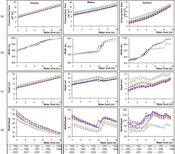
10
increases of the cross-section area have been observed accompanying the downcut-ting of river channels at all the three stations examined (Fig. 3a). For example, the cross-section areas when the water level was 0 m increased 22.6% at Gaoyao, 16.4% at Makou, and 170.3% at Shanshui from 1990 to 2003. No obvious changes of channel width were observed at Gaoyao and Makou in the lower Xijiang, while a narrowing of
15
150 m was recorded at Sanshui since 1998 for higher water levels (>5.0 m) (Fig. 3b). Depth continuously increased from 1990 to 2003 with an average rate of 13cm/year at Gaoyao, 16cm/year at Makou, and 26 cm/year at Sanshui (Fig. 3c). The average width/depth ratio of the channel for different water levels decreased significantly be-tween 1990 and 2003 from 78.2 to 66.9 at Gaoyao, from 46.5 to 40.2 at Makou, and
20
138.1 to 73.6 at Sanshui (Fig. 3d).
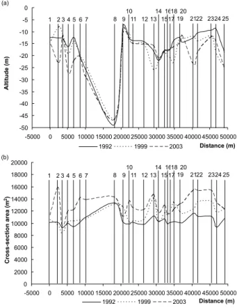
4.2 Channel geometry change along the longitudinal direction in the lower Xijiang
Channel geometric changes have taken place not only at the gauging stations but also along the whole lower Xijiang River. The thalweg line stretching 50 km from Gaoyao down to Makou shows down cuts from 1992 to 2003, though there were occasional
25
depositions (Fig. 4a). Between 1992 and 1999, over 40% of the stretch had down cut over 2 m with the deepest down cut 9.86 m nearby Makou. Between 1999 and 2003, the cross-sections near Gaoyao showed more significant downcutting with the
HESSD
4, 2205–2227, 2007
Channel incision of the lower Pearl River
(China) X. X. Lu et al. Title Page Abstract Introduction Conclusions References Tables Figures ◭ ◮ ◭ ◮ Back Close
Full Screen / Esc
Printer-friendly Version Interactive Discussion
EGU
deepest down cuts 14.98 m. Between 1992 and 2003, the rapid channel incision of the stretch between Gaoyao and Makou was observed with down cut ranging from 1.62 m to 11.29 m. Most of the severely incised cross-sections (>2 m) were located near Gaoyao or near Makou, and the incision showed an upstream trend in recent years. The cross-section areas increased corresponding to the downcutting of river
5
channels (Fig. 4b).
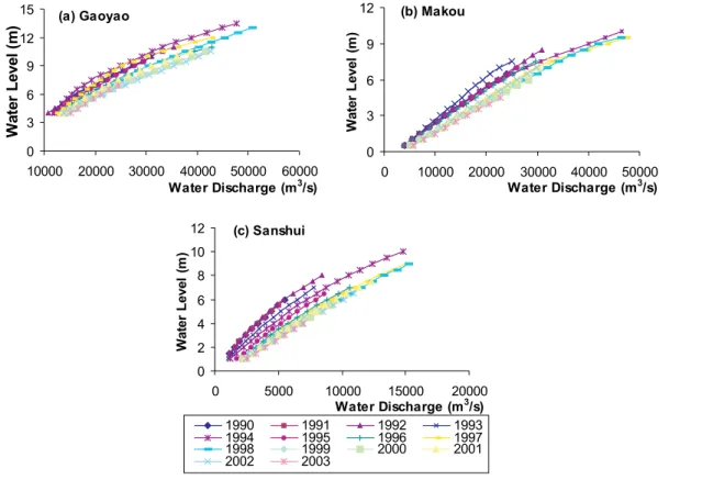
4.3 River hydraulics change: Stage-discharge relationship
The relations between water level and water discharge were changed at the three sites as a result of the rapid downcutting (Fig. 5). Since 1990, especially after 1994, water discharge increased at a given water level, with the increased depth and cross-section
10
area of the channel (Fig. 5). For example, when water level was 10 m, water discharge increased by 2900 (9.4%), 3400 (25.0%) and 6500 m3/s (15.0%) in 1999 as compared to 1988, at Gaoyao, Sanshui and Makou respectively. One the other hand, the water level decreased with a given discharge as a result of downcutting. For example, the water level between 1992 and 2002 was lowered by 2.0 m on average at Gaoyao,
15
1.5 m at Makou, and 3.0 m at Sanshui. At Gaoyao station, the lowering of flood water level had shown a gradually increasing tendency with the downcutting of river channel (Table 1). On average, the lowering of flood water level with different water discharges increased less than 1.5 m in the late 1990s and about 2.0 m in the 2000s compared with corresponding flood water levels pre-1990s. The observed lowering of water levels as
20
a result of the downcutting is dramatic, given the short period and the large drainage area compared to the documented rivers, such as the Wisloka River with a drainage area of 4096 km2, where the water level lowering was only <1.0 m over the period of about 30 years (Wy˙zga, 1997; 2001; Lach and Wy˙zga, 2002).
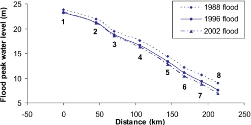
The impact of the rapid incision on the water level had reached further upstream. For
25
example, from Wuzhou down to Makou the flood water levels for a given discharge of 43 000 m3/s declined progressively, with 0.5 m decline at Wuzhou and 2.05 m decline at Makou in 2002 compared to 1988 (Fig. 6). As a result, the flood water surface had
HESSD
4, 2205–2227, 2007
Channel incision of the lower Pearl River
(China) X. X. Lu et al. Title Page Abstract Introduction Conclusions References Tables Figures ◭ ◮ ◭ ◮ Back Close
Full Screen / Esc
Printer-friendly Version Interactive Discussion
EGU
increased the gradient, potentially causing more damages. For example, from Wuzhou to Makou the flood water surface slope on average had an increase from 0.063‰ for the 1988 flood to 0.066‰ for the 1996 flood and to 0.070‰ for the 2002 flood. In addition to the increase in the flood damages, the increased water surface slope could increase the sediment transport capacity and accelerate channel incision further, which
5
could in turn modify the morphology of the river channel. 4.4 Water exchange between the Xijiang and the Beijiang
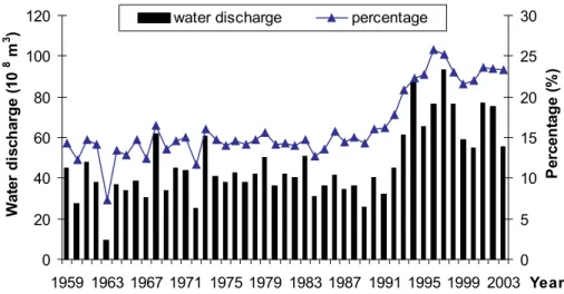
The channel incision also caused significant change in the water exchange between the Xijiang and the Beijiang through the Shixianyao waterway connection (Fig. 7). The Shixianyao waterway played an important role in regulating the water from the Beijiang
10
to the Xijiang before the occurrences of the massive channel incision. The channel bed at Sanshui (Beijiang) was around 10 m higher than at Makou (Xijiang), hence the water would flow from the Beijiang to the Xijiang under normal flood condition. Due to the fact that the Beijiang channel at Sanshui was more incised than the Xijiang at Makou after the 1990s, the Shixianyao waterway has began to play its opposite role in regulating
15
the water from the Xijiang to the Beijiang. As a result, the annual water discharge at Sanshui increased significantly since the 1990s (Fig. 7). The average percentage of the water discharge at Sanshui in terms of the sum of the water discharge at Sanshui and Makou increased from 14.4% to 23.1% from 1959–1992 to 1993–2003.
5 Discussions
20
River channel change like incision or deposition is a natural process for an alluvial river. However, increasing human activities such as sand mining, construction of reser-voirs and land use alterations have accelerated this geomorphological process (Surian, 1999; Rinaldi, 2003; Li et al., 2007). The causes of such rapid incision require an in-depth analysis on the water discharge and sediment flux changes as a result of various
HESSD
4, 2205–2227, 2007
Channel incision of the lower Pearl River
(China) X. X. Lu et al. Title Page Abstract Introduction Conclusions References Tables Figures ◭ ◮ ◭ ◮ Back Close
Full Screen / Esc
Printer-friendly Version Interactive Discussion
EGU
human activities and possible climate variations. Because of lack of data, this paper provides a very preliminary analysis only from the aspect of sediment depletion.
5.1 Impact of sand mining on channel incision
The intensive in-channel sand mining appears to be the principal factor causing the rapid channel incision in the lower Pearl River. During the period 1984–1999, the
av-5
eraged annual sediment extracted through mining from the Pearl River Delta was 46– 53×106m3(equivalent to 59.8–68.9 MT, which is almost the same as the total amount of annual sediment fluxes in the entire Pearl River), but the annual sediment deposited in the channel bed in the meantime was only 17.7 MT (Peng et al., 2003). The ex-tracted sediment principally comes from the coarse fraction of the bed material, so the
10
in-channel sand mining imposes direct impacts on river channel incision. The demand for sand as construction material has been extremely high since the economic reform in the late 1970s across the Pearl River Delta, one of the rapidly industrializing and im-portant agricultural areas in China. The total population in the Delta region (including Hong Kong and Macau) increased from 12.59 million to 50.0 million with the
urbaniza-15
tion rate of >70%. Some of the cities in the region were literally built from scratch. For example, Dongguan has been built from a tiny fishing village before 1978 to a city with a population of 6.5 million. As a result, sediment mining has been intensive in the large scale, and the rapid channel incision has been very common across the whole delta area. For example, it was reported that the channel was incised over 8 m from 1989 to
20
2001 in the channel of the river mouth to South China Sea (PRWRC, 2003).
5.2 Impact of sediment decline on channel incision
Apart from sediment mining, there may be other causes of river channel incision, such as sediment reduction due to climate change, and land use change in the drainage basin, e.g. reforestation/afforestation, damming and reservoir constructions. The
long-25
HESSD
4, 2205–2227, 2007
Channel incision of the lower Pearl River
(China) X. X. Lu et al. Title Page Abstract Introduction Conclusions References Tables Figures ◭ ◮ ◭ ◮ Back Close
Full Screen / Esc
Printer-friendly Version Interactive Discussion
EGU
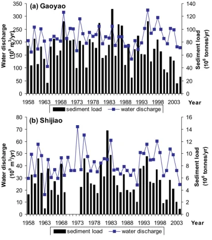
Beijiang (at Shijiao) (Fig. 8) indicates that slight increases of water discharge and signif-icant decreases of sediment load have taken place since the early 1990s in both rivers (Zhang et al., 2007a). The averaged annual water discharges were 214.9×10⁹m3 from 1958–1990 and 231.7×10⁹m3from 1991–2004 at Gaoyao, and 40.9×10⁹m3and 43.8×10⁹m3 at Shijiao for the above two periods respectively. The averaged annual
5
sediment load was 71.4 MT and 57.9 MT at Gaoyao, and 5.8 and 4.8 MT at Shijiao for the two periods respectively. The slightly increased water discharge and significantly decreased sediment load since the early 1990s could contribute to the channel incision to some extent.
6 Conclusions
10
A dramatic channel incision (>10 m in the deepest cut) has occurred since the 1990s in the lower Pearl River. The channel geometry and the river hydraulics have been dramatically changed due to the rapid downcutting. For example, the channel incision had caused lower water levels across the entire lower reaches of the river. The water exchange between the two major tributaries of the Pearl River, the Xijiang and Beijiang,
15
had also been significantly changed due to the channel incision. The rapid channel incision also contributes to the increasing salty water intrusion and subsequent water shortage in the Pearl River Delta region as a result of lower water levels. For example, the salt water intrusion from the end of 2005 to the beginning of 2006 caused a huge problem for the fresh water supply over one month for the cities of Macau, Zhuhai,
20
Zhongzhan and Fanyu etc. in the Delta region (Fig. 1). The salt content (Cl−) of the water supply areas was as high as 6415 mg/l (the national standard for drinking water is <250 mg/l). As a result the local authority had to divert extra water from over 10 large reservoirs upstream to increase water discharge and minimize the salt content for water supply to these cities during the dry period.
25
These channel changes can result in other environmental and social-economic con-sequences such as difficulties in navigation management, loss of riparian land and
HESSD
4, 2205–2227, 2007
Channel incision of the lower Pearl River
(China) X. X. Lu et al. Title Page Abstract Introduction Conclusions References Tables Figures ◭ ◮ ◭ ◮ Back Close
Full Screen / Esc
Printer-friendly Version Interactive Discussion
EGU
infrastructure, flood hazard and the alteration of aquatic and riparian ecosystems, but few studies have been conducted so far. Although the Chinese government has en-hanced the management of in-channel sand mining in the lower Pearl River since the end of the 1990s, the illegal mining activities are still rampant. Tighter restrictions on in-channel sand mining should be proposed in order to reduce or recover the channel
5
incision as well as its detrimental effects in the lower Pearl River.
The rapid channel incision was principally the result of extensive sand mining in the lower Pearl River and the delta region due to the booming economy in the Pearl Delta region, but an in-depth study is required to pin-point the exact reasons behind such rapid incision, and to develop quantitative relations between the incision and sediment
10
depletion. The observed dramatic river bed downcutting as a result of sediment reduc-tion has important implicareduc-tions for river management, as the large Chinese rivers have seen a dramatic depletion of sediment fluxes due to the combined effects of declining rainfall, dam constructions, water diversion, reforestation and afforestation, and sedi-ment mining over the recent decades. A better understanding of human impact on river
15
channels is of great importance for river engineering and environmental management.
Acknowledgements. This research was funded by the National University of Singapore (Grant
Number R-109-000-054-112).
References
Arnaud-Fassetta, G.: River channel changes in the Rhone Delta (France) since the end of the
20
Little Ice Age: geomorphological adjustment to hydroclimatic change and natural resource management, Catena, 51, 141–172, 2003.
Bravard, J. P., Amoros, C., Pautou, G. ,et al.: River incision in South-east France: morphological phenomena and ecological effects, Regulated Rivers: Research Management, 13, 75–90, 1997.
25
Bravard, J. P., Kondolf, G. M., and Pi ´egay, H.: in Incised River Channels: Processes, Forms, Engineering and Management, edited by Darby, S. E., and Simon, A., 303–341, Wiley, Chich-ester, 1999.
HESSD
4, 2205–2227, 2007
Channel incision of the lower Pearl River
(China) X. X. Lu et al. Title Page Abstract Introduction Conclusions References Tables Figures ◭ ◮ ◭ ◮ Back Close
Full Screen / Esc
Printer-friendly Version Interactive Discussion
EGU Chen, X. Q., Zhou Q. J., and Zhang E. F.: In-channel sand extraction from the mid-lower
Yangtze channels and its management: problems and challenges, J. Environ. Planning Man-age., 49, 309–320, 2006.
Collins, B. and Dunne, T.: Gravel transport, gravel harvesting and channel-bar degradation in rivers draining the Southern Olympic Mountains, Washington, USA, Environmental Geology
5
and Water Science, 13, 213–224, 1989.
Collins, B. and Dunne, T.: Fluvial geomorphology and river-gravel mining: a guide for plan-ners, case studies included, Special Publication 98, California Department of Conservation, Division of Mines and Geology, 1990.
Davis, J., Bird, J., Finlayson, B., and Scott, R.: The management of gravel extraction in alluvial
10
rivers: a case study from the Avon River, southeastern Australia, Physical Geography, 21, 133–154, 2000.
Gaillot, S. and Pi ´egay, H.: Impact of gravel mining on stream channel and coastal sediment supply: example of the Calvi Bay in Corsica (France), J. Coastal Res., 15, 774–788, 1999. Harvey, M. D. and Shumm, S. A.: in Erosion and Sedimentation in the Pacific Rim, edited
15
by: Beschta, R. L., Blinn, T., Grant, G. E., et al., 451–460, International Association of Hydrological Sciences, Wallingford, 1987.
Kondolf, G. M.: Environmental planning in the regulation and management of instream gravel mining in California, Landscape and Urban Planning, 29, 185–199, 1994.
Kondolf, G. M.: Environmental Management - Hungry water: Effects of dams and gravel mining
20
on river channels, Environ. Manage., 21, 533–551, 1997.
Kondolf, G. M. and Swanson, M. L.: Channel adjustments to reservoir construction and in-stream gravel mining, Stony Creek, California, Environmental Geology and Water Science 21, 256–269, 1993.
Lach, J. and Wy˙zga, B.: Channel incision and flow increase of the upper Wisloka River, south
25
Poland, subsequent to the reafforestation of its catchment, Earth Surface Processes and Landforms, 27, 445–462, 2002.
Li, L. Q., Lu, X. X., and Chen, Z.: River channel change during the last 50 years in the middle Yangtze River: an example of the Jianli reach, Geomorphology, 85, 185–196, 2007.
Milliman, J. D. and Meade, R. H.: World-wide delivery of river sediment to the oceans, J. Geol.
30
91, 1–21, 1983.
Ministry of Water Resources of China: Code for River Suspended Sediment Measurement (GB 50159-92), China Planning Press, Beijing, 1992.
HESSD
4, 2205–2227, 2007
Channel incision of the lower Pearl River
(China) X. X. Lu et al. Title Page Abstract Introduction Conclusions References Tables Figures ◭ ◮ ◭ ◮ Back Close
Full Screen / Esc
Printer-friendly Version Interactive Discussion
EGU Page, K. J. and Heerdegen, R. G.: Channel change on the lower Manawatu River, New Zealand
Geographer, 41, 35–38, 1985.
Peiry, J. L.: Channel degradation in the middle Arve river, France, Regulated Rivers: Research and Management, 1, 183–188, 1987.
Peng, J., He, S., Liao, W., and Zhang, S.: Large scale system simulation for flood and anti-flood
5
counter measures in Pearl River delta, Journal of Hydraulic Engineering (SHUILI XUEBAO), 11, 78–85, 2003 (in Chinese).
Petit, F. Poinsart, D., and Bravard, J. P.: Channel incision, gravel mining and bedload transport in the Rhone river upstream of Lyon, France, Catena, 26, 209–226, 1996.
Petts, G. E. and Amoros C.: Fluvial Hydrosystems, Chapman & Hall, London, 1996.
10
Rinaldi, M.: Recent channel adjustments in alluvial rivers of Tuscany, Central Italy, Earth Sur-face Processes and Landforms, 28, 587–608, 2003.
Rinaldi, M. and Simon, A.: Bed-level adjustments in the Arno River, Central Italy, Geomorphol-ogy, 22, 57–71, 1998.
Rinaldi, M., Wyzga, B., and Surian, N.: Sediment mining in alluvial channels: physical effects
15
and management perspectives, River Res. Applic., 21, 805–828, 2005.
Rovira, A., Batalla, R. J., and Sala, M.: Response of a river sediment budget after historical gravel mining (The lower Tordera, NE Spain), River Res. Applic., 21, 829–847, 2005. Sandecki, M. and Avila, C. C.: in Storm-Induced Geologic Hazards: Case Histories from the
1992–1993 Winter in Southern California and Arizona, edited by Larson, R. A. and Slosson,
20
J.E., pp. 39–48, Geological Society of America, Boulder, CO, USA, 1997.
Sear, D. and Archer, A. D.: in Gravel-Bed Rivers in the Environment, edited by Klingeman, P. C. et al., pp. 415–432, Water Resources Publications, LLC: Highlands Ranch, CO. USA, 1998. Surian, N.: Channel changes due to river regulation: the case of the Piave River, Italy, Earth
Surface Processes and Landforms, 24, 1135–1151, 1999.
25
Surian, N. and Rinaldi, M.: Morphological response to river engineering and management in alluvial channels in Italy, Geomorphology, 50, 307–326, 2003.
Pearl River Water Resources Committee (PRWRC): The Zhujiang Archive, Vol. 1, Guangdong Science and Technology Press, Guangzhou, 1991. (in Chinese).
Pearl River Water Resources Committee (PRWRC): Sediment Report.http://www.pearlwater.
30
gov.cn/index.jsp, 2003 (in Chinese).
Wang, H. J., Yang, Z. S., Saito, Y., Liu, J. P., Sun, X. X., and Wang, Y.: Stepwise decrease of the Hunaghe (Yellow River) sediment load (1950–2005): Impacts of climate change and
HESSD
4, 2205–2227, 2007
Channel incision of the lower Pearl River
(China) X. X. Lu et al. Title Page Abstract Introduction Conclusions References Tables Figures ◭ ◮ ◭ ◮ Back Close
Full Screen / Esc
Printer-friendly Version Interactive Discussion
EGU human activities, Global and Planetary Change, 57, 331–354, 2007.
Wy˙zga, B. A.: Methods for studying the response of flood flows to channel change, Journal of Hydrology, 198, 271–288, 1997.
Wy˙zga, B. A.: Geomorphologist’s criticism of the engineering approach to channelization of gravel-bed rivers: case study of the Raba River, Polish Carpathians, Environ. Manage., 28,
5
341–358, 2001.
Xu, J. X.: Sediment flux to the sea as influenced by Changing human activities and precipitation: example of the Yellow River, China, Environ. Manage., 31, 328–341, 2003.
Yang, Z., Wang, H., Saito, Y., Milliman, J. D., Xu, K., Qiao, S., and Shi, G.: Dam impacts on the Changjiang (Yangtze River) sediment discharge to the sea: the past 55 years and after the
10
Three Gorges Dam, Water Resour. Res., 42, W04407, doi:10.1029/2005WR003970, 2006. Yang, S. L., Zhang, J., Dai, S. B., Li, M., and Xu, X. Y.: Effect of deposition and erosion within
the main river channel and large lakes on sediment delivery to the estuary of the Yangtze River, J. Geophys. Res., 112, F02005, doi:10.1029/2006JF000484, 2007.
Zhang, S. R., Lu, X. X. Higgitt, D. L., Chen, C. T. A., Han, J, T. and Sun, H. G.: Recent changes
15
of water discharge and sediment load in the Zhujiang (Pearl River) Basin, China, Global and Planetary Change, in press, doi:10.1016/j.gloplacha.2007.04.003, 2007a.
Zhang, S. R., Lu, X. X., Higgitt, D. L., Chen, C. T. A., Sun, H. G., and Han, J. T.: Water chemistry of the Zhujiang (Pearl River): Natural processes and anthropogenic influences, J. Geophys. Res., 112, F01011, doi:10.1029/2006JF000493, 2007b.
HESSD
4, 2205–2227, 2007
Channel incision of the lower Pearl River
(China) X. X. Lu et al. Title Page Abstract Introduction Conclusions References Tables Figures ◭ ◮ ◭ ◮ Back Close
Full Screen / Esc
Printer-friendly Version Interactive Discussion
EGU
Table 1. The lowering of flood water level accompanying downcutting of river channel at Gaoyao station, under similar water discharge.
Date Water discharge (m3/s)
Water level (m)
Lowering of water level (m) 1979.08.26 1997.08.13 2001.07.19 31700 31800 31500 10.99 9.67 8.89 – 1.32 2.10 1983.06.26 1999.07.15 2000.06.14 2004.07.14 34400 35100 34500 37100 10.83 9.35 9.00 8.46 – 1.48 1.83 2.37 1988.09.06 1996.07.23 2002.06.20 44800 43500 42000 12.21 11.11 10.38 – 1.10 1.83
HESSD
4, 2205–2227, 2007
Channel incision of the lower Pearl River
(China) X. X. Lu et al. Title Page Abstract Introduction Conclusions References Tables Figures ◭ ◮ ◭ ◮ Back Close
Full Screen / Esc
Printer-friendly Version Interactive Discussion
EGU
Fig. 1. The lower Pearl River and its delta area showing the study sites (Gaoyao, Sanshui and Makou), and the stretch of the channel from Gaoyao to Makou.
HESSD
4, 2205–2227, 2007
Channel incision of the lower Pearl River
(China) X. X. Lu et al. Title Page Abstract Introduction Conclusions References Tables Figures ◭ ◮ ◭ ◮ Back Close
Full Screen / Esc
Printer-friendly Version Interactive Discussion EGU (a) Gaoyao -20 -10 0 10 20 -100 100 300 500 700 900 1100 Distance (m) A lti tu d e (m ) (b) Makou -30 -20 -10 0 10 20 -100 100 300 500 700 900 Distance (m) A lti tu d e (m ) (c) Sanshui -16 -8 0 8 16 0 200 400 600 800 1000 1200 1400 Distance (m) Al ti tu d e (m ) 1990 1991 1992 1993 1994 1995 1996 1997 1998 1999 2000 2001 2002 2003
Fig. 2. The cross-section channel profiles from 1990 to 2003 determined from the repeated field surveys at stations (a) Gaoyao, (b) Makou and (c) Sanshui.
HESSD
4, 2205–2227, 2007
Channel incision of the lower Pearl River
(China) X. X. Lu et al. Title Page Abstract Introduction Conclusions References Tables Figures ◭ ◮ ◭ ◮ Back Close
Full Screen / Esc
Printer-friendly Version Interactive Discussion EGU Gaoyao 0 4 8 12 16 20 0 2 4 6 8 10 Water level (m) C ro ss-sect io n A rea (1 0 3m 2) Makou 0 4 8 12 16 20 0 2 4 6 8 10 Water level (m) C ro ss-sect io n A rea (1 0 3m 2) Sanshui 0 2 4 6 8 10 0 2 4 6 8 10 Water level (m) C ro ss-sect io n A rea (1 0 3m 2) 800 850 900 950 1000 0 2 4 6 8 10 Water level (m) Wi d th (m ) 600 700 800 900 0 2 4 6 8 10 Water level (m) Wi d th (m ) 300 500 700 900 1100 0 2 4 6 8 10 Water level (m) Wi d th (m ) 0 4 8 12 16 20 0 2 4 6 8 10 Water level (m) De p th (m ) 0 4 8 12 16 20 24 0 2 4 6 8 10 Water level (m) De p th (m ) 0 2 4 6 8 10 0 2 4 6 8 10 Water level (m) De p th (m ) 50 60 70 80 90 100 110 0 2 4 6 8 10 Water level (m) W idt h/ D e pt h 1990 1991 1992 1993 1994 1995 1996 1997 1998 1999 2000 2001 2002 2003 30 40 50 60 0 2 4 6 8 10 Water level (m) W idt h/ D e pt h 1990 1991 1992 1993 1994 1995 1996 1997 1998 1999 2000 2001 2002 2003 30 60 90 120 150 180 0 2 4 6 8 10 Water level (m) W idt h/ D e pt h 1990 1991 1992 1993 1994 1995 1996 1997 1998 1999 2000 2001 2002 2003 (a) (b) (c) (d)
Fig. 3. The channel geometry change at stations Gaoyao, Makou and Sanshui from 1990 to 2003 (a) cross-section area (b) width (c) depth (d) width/depth ratio.
HESSD
4, 2205–2227, 2007
Channel incision of the lower Pearl River
(China) X. X. Lu et al. Title Page Abstract Introduction Conclusions References Tables Figures ◭ ◮ ◭ ◮ Back Close
Full Screen / Esc
Printer-friendly Version Interactive Discussion EGU -50 -45 -40 -35 -30 -25 -20 -15 -10 -5 0 -5000 0 5000 10000 15000 20000 25000 30000 35000 40000 45000 50000 Distance (m) Altitude (m) 1992 1999 2003 1 2 3 4 5 6 7 8 9 10 11 12 13 14 1517 1618 19 21 20 22 2324 25 (a) 0 2000 4000 6000 8000 10000 12000 14000 16000 18000 20000 -5000 0 5000 10000 15000 20000 25000 30000 35000 40000 45000 50000 Distance (m) Cross-section area (m 2) 1992 1999 2003 1 2 3 4 5 6 7 8 9 10 11 12 13 14 15 17 1618 19 21 20 22 2324 25 (b)
Fig. 4. The thalweg change of longitude profile of the reach between Gaoyao to Makou in 1992, 1999, and 2003 (a) altitude (b) cross-section area (25 cross-sections between Gaoyao and Makou, 1=Gaoyao, 25=Makou). Cross-sections in 1992 and 1999 were obtained based on the river channel topographic maps, and the cross-sections in 2003 were surveyed in the field.
HESSD
4, 2205–2227, 2007
Channel incision of the lower Pearl River
(China) X. X. Lu et al. Title Page Abstract Introduction Conclusions References Tables Figures ◭ ◮ ◭ ◮ Back Close
Full Screen / Esc
Printer-friendly Version Interactive Discussion EGU (a) Gaoyao 0 3 6 9 12 15 10000 20000 30000 40000 50000 60000 Water Discharge (m3/s) W at er L evel (m ) (b) Makou 0 3 6 9 12 0 10000 20000 30000 40000 50000 Water Discharge (m3/s) Wat e r L evel (m ) (c) Sanshui 0 2 4 6 8 10 12 0 5000 10000 15000 20000 Water Discharge (m3/s) Wat e r L evel (m ) 1990 1991 1992 1993 1994 1995 1996 1997 1998 1999 2000 2001 2002 2003
Fig. 5. The changes in the relations between water level and water discharge caused by chan-nel incision during the period 1990–2003 at stations (a) Gaoyao, (b) Makou and (c) Sanshui.
HESSD
4, 2205–2227, 2007
Channel incision of the lower Pearl River
(China) X. X. Lu et al. Title Page Abstract Introduction Conclusions References Tables Figures ◭ ◮ ◭ ◮ Back Close
Full Screen / Esc
Printer-friendly Version Interactive Discussion EGU 5 10 15 20 25 -50 0 50 100 150 200 250 Distance (km) F lo o d p eak w at er level (m ) 1988 flood 1996 flood 2002 flood 1 2 3 4 5 6 7 8
Fig. 6. Flood peak water level in 1988, 1996, and 2002 floods at a discharge of 43 000 m3/s along the stretch from Wuzhou to Makou. 1. Wuzhou; 2. Ducheng; 3. Deqing; 4. Liudu; 5. Shun-wei; 6. Gaoyao; 7. Guangli; 8. Makou.
HESSD
4, 2205–2227, 2007
Channel incision of the lower Pearl River
(China) X. X. Lu et al. Title Page Abstract Introduction Conclusions References Tables Figures ◭ ◮ ◭ ◮ Back Close
Full Screen / Esc
Printer-friendly Version Interactive Discussion EGU 0 20 40 60 80 100 120 1959 1963 1967 1971 1975 1979 1983 1987 1991 1995 1999 2003 Year Wat e r d is ch ar g e (1 0 8 m 3 ) 0 5 10 15 20 25 30 P e rc e n ta g e (% )
water discharge percentage
Fig. 7. The long-term variations of water discharge at Sanshui and the percentage of water discharge at Sanshui in terms of the sum of water discharge of Sanshui and Makou.
HESSD
4, 2205–2227, 2007
Channel incision of the lower Pearl River
(China) X. X. Lu et al. Title Page Abstract Introduction Conclusions References Tables Figures ◭ ◮ ◭ ◮ Back Close
Full Screen / Esc
Printer-friendly Version Interactive Discussion EGU (a) Gaoyao 0 50 100 150 200 250 300 350 1958 1963 1968 1973 1978 1983 1988 1993 1998 2003 Year Wat e r d isch ar g e (1 0 9m 3/y r) 0 20 40 60 80 100 120 140 S e di m e nt loa d (1 0 6to n n es/ yr )
sediment load water discharge (b) Shijiao 0 10 20 30 40 50 60 70 80 1958 1963 1968 1973 1978 1983 1988 1993 1998 2003 Year Wat e r d isch ar g e (1 0 9 m 3 /y r) 0 2 4 6 8 10 12 14 16 S e di m e nt loa d (1 0 6 to n n es/ yr )
sediment load water discharge
Fig. 8. The variations of water discharge and sediment load over the past decades in the Xijiang and Beijiang at stations (a) Gaoyao (b) Shijiao.